
Freshwater Mussel Survey for the Miramichi River Watershed
16
Freshwater Mussel Survey for the Miramichi River Watershed MREAC, 2008 Kara L. Baisley
Transcript of Freshwater Mussel Survey for the Miramichi River Watershed

Freshwater
Mussel Survey
for the
Miramichi
River
Watershed
MREAC, 2008
Kara L. Baisley

Freshwater Mussel Survey of the Miramichi River Watershed – MREAC, 2008
i
Table of Contents
List of Figures ................................................................................................................................. ii
List of Tables ................................................................................................................................... ii
1.0. Introduction .......................................................................................................................... 1
2.0. Methodology ........................................................................................................................ 2
3.0. Results and Observations ..................................................................................................... 5
4.0. Discussion ............................................................................................................................ 9
4.1. Eastern Pearlshell (Margaritifera margaritifera)............................................................... 9
4.2. Eastern Elliptio (Elliptio complanata) .............................................................................. 9
4.3. Eastern Floater (Pyganodon cataracta) .......................................................................... 10
5.0. Conclusion .......................................................................................................................... 11
6.0. References .......................................................................................................................... 12
Appendix A ................................................................................................................................... 13

Freshwater Mussel Survey of the Miramichi River Watershed – MREAC, 2008
ii
List of Figures
Figure 1. Map of Miramichi River watershed showing MREAC freshwater mussel survey site
locations for 2008.............................................................................................................. 4
Figure 2. Bar chart demonstrating the number of live mussels of three species found at each site
........................................................................................................................................................ .6
Figure 3. Species percentages of total live mussels recorded during summer of 2008 ................... 7
Figure 4. Map of the Miramichi River watershed showing site locations of major freshwater
mussel surveys completed within the last ten years: by MREAC in 2008 and Bredin in
2002 and 2006-07 (Bredin 2002, COSEWIC in press) .................................................... 8
List of Tables
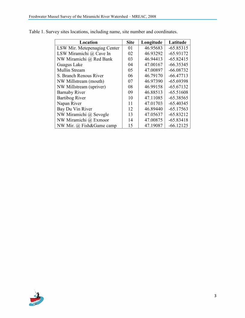
Table 1. Survey sites locations, including name, site number and coordinates. ............................. 3
Table 2. Number of live mussels recorded at survey sites .............................................................. 5

Freshwater Mussel Survey of the Miramichi River Watershed – MREAC, 2008
1
1.0. Introduction
The Miramichi River Environmental Assessment Committee (MREAC) undertook a freshwater
mussel surveys at a range of locations within the Miramichi River watershed during the summer
months of 2008. Freshwater mussels are evident in the Miramichi River and tributaries, but little
is known about the variety of species, distribution and population size. The Miramichi River is
world renowned for its Atlantic salmon, which is a host to the parasitic larval stage of some
freshwater mussel species. Water quality is generally very good throughout the Miramichi River
watershed as much of the land is uninhabited or crown land. However, some forestry, mining,
agriculture and other industrial activities are carried out within the watershed and may locally
impact water quality of a number of tributaries. As freshwater mussels can be good water quality
indicators, further understanding of the abundance and distribution of species throughout the
watershed is important to assessing and monitoring water quality conditions within the
Miramichi River and its many tributaries.
Prior to this project, only limited freshwater mussel surveys had been conducted in the
Miramichi River watershed, including surveys at a total of 19 sites by freshwater mussel
specialist, Kate Bredin, in 2002 and 2006. A sizeable population of a rare freshwater mussel
species, the Brook Floater (Alasmidonta varicosa), was discovered in the Southwest Miramichi
River in 2006. The Brook Floater is currently being assessed by the Committee on the Status of
Endangered Wildlife in Canada (COSEWIC) and has a National General Status Rank of “may be
at risk” in New Brunswick. The existence of this rare species in a tributary of the Miramichi
River makes freshwater mussel surveys of the watershed doubly important, to more fully
delineate this species’ population and range.
The main objective of this project was to conduct freshwater mussel surveys in the Miramichi
River watershed, focusing on the Northwest Miramichi and other areas not yet surveyed. The
second objective of the project was to search for additional records for Brook Floaters to assist
with the Status Report for this species for the COSEWIC.

Freshwater Mussel Survey of the Miramichi River Watershed – MREAC, 2008
2
2.0. Methodology
The field method used was similar to that described in the report “Inventaire des moules d’eau
donce dans les rivieres Kouchibouquac, Kouchibouguacsis et Black du Parc national
Kouchibouguac, �ouveau-Brunswick” published in December 2002 by Parks Canada (Beaudet,
et al., 2002). Field work began in June 2008 after staff training from Kate Bredin and ended in
September 2008 when water temperatures had cooled and mussels were less likely to be visible
at the surface. Surveyors consisted of MREAC staff: Kara Baisley, MREAC Biologist; Harry
Collins, MREAC Executive Director; and MREAC summer students, Melissa Price and Sandra
Ross. Volunteers Nelson Cloud and Nelson Poirier also assisted with surveying on occasion.
Sites were chosen based on 1) their location - either on the Northwest Miramichi, the main focus
of our study, or on other un-surveyed large tributaries; 2) accessibility; and, 3) public reports of
mussel sightings. Site locations and coordinates can be found in Table 1; Figure 1 maps the
survey sites within the Miramichi River watershed. Teams of 2-4 people searched at each site for
a cumulative total of four person-hours. Each surveyor used a Plexiglas-bottom viewing bucket
and searched different sections of the survey site, concentrating on the river edges so that
shorelines could also be inspected for empty shells. Waters deeper than 1.2 meters were not
surveyed, preventing coverage of the entire river width for larger, deeper rivers. Two metre long
poles with a mesh catch basket at the end were used to pick up mussels from the river bed in
deep water.
Surveyors removed visible mussels from the water for identification and then placed them back.
A laminated identification key was created to assist surveyors with on-site identification. Dead
mussels present on shore were also counted and some shells were collected as samples. Sightings
of the empty mussel shells helped identify key areas of the river where live mussels were likely
to be discovered. A tally of dead and live mussels was kept by the surveyor for all species found.
When the survey period ended, the numbers of mussels of each species found were totalled.
Water temperate and pH were also recorded, along with habitat observations and site photos.
Freshwater Mussel Survey of the Miramichi River Watershed – MREAC, 2008
3
Table 1. Survey sites locations, including name, site number and coordinates.
Location Site Longitude Latitude
LSW Mir. Metepenagiag Center 01 46.95683 -65.85315
LSW Miramichi @ Cave In 02 46.93292 -65.93172
NW Miramichi @ Red Bank 03 46.94413 -65.82415
Guagus Lake 04 47.00167 -66.35345
Mullin Stream 05 47.00897 -66.08732
S. Branch Renous River 06 46.79170 -66.47713
NW Millstream (mouth) 07 46.97390 -65.69398
NW Millstream (upriver) 08 46.99158 -65.67132
Barnaby River 09 46.88513 -65.51608
Bartibog River 10 47.11085 -65.38565
Napan River 11 47.01703 -65.40345
Bay Du Vin River 12 46.89440 -65.17563
NW Miramichi @ Sevogle 13 47.05637 -65.83212
NW Miramichi @ Exmoor 14 47.00875 -65.83418
NW Mir. @ Fish&Game camp 15 47.19087 -66.12125

Freshwater Mussel Survey of the Miramichi River Watershed – MREAC, 2008
4
Figure 1. Map of Miramichi River watershed showing MREAC freshwater mussel survey site
locations for 2008

Freshwater Mussel Survey of the Miramichi River Watershed – MREAC, 2008
5
3.0. Results and Observations
MREAC conducted freshwater mussel surveys at 15 sites within the Miramichi River watershed.
At three of the 15 sites surveyed no mussels were found, sites 01, 02 and 07. Three different
mussel species were identified from twelve sites, with a total count of 3162 mussels recorded.
Table 2 shows the total number of live mussels recorded at each site and Figure 2 demonstrates
the results in a bar graph.
Table 2. Number of live mussels recorded at survey sites
Location Site Eastern
Pearlshell Eastern Elliptio
Eastern Floater
LSW Mir. Metepenagiag Center 01 0 0 0
LSW Miramichi @ Cave In 02 0 0 0
NW Miramichi @ Red Bank 03 0 16 0
Guagus Lake 04 7 0 57
Mullin Stream 05 368 0 0
S. Branch Renous River 06 280 0 0
Northwest Millstream (mouth) 07 0 0 0
Northwest Millstream (upriver) 08 124 0 0
Barnaby River 09 0 500 0
Bartibog River (Fins&Feathers) 10 4 0 0
Napan River (Johnson's Bridge) 11 4 0 1
Bay Du Vin River (Rte.11 Bridge) 12 1005 0 0
NW Mir. River @ Sevogle 13 5 1 0
NW Mir. River @ Exmoor 14 33 1 0
NW Mir. River @ Fish&Game camp 15 756 0 0
Total 2586 518 58

Freshwater Mussel Survey of the Miramichi River Watershed – MREAC, 2008
6
Figure 2. Bar chart demonstrating the number of live mussels of three species found at each site
At eight of the 12 sites where mussels were present, only one mussel species was present; and
four of the sites two mussel species were present. The most abundant mussel in the Miramichi
watershed was the Eastern Pearlshell (Margaritifera margaritifera) with 2586 live individuals
recorded from 10 sites, equalling 82% of the live mussels recorded during this project. The 10
sites where this mussel was found were: sites 04, 05, 06, 08, 10-15. The largest count was at site
12 on the Bay Du Vin River, where 1005 live M. margaritifera were recorded.
The second most abundant mussel species found was the Eastern Elliptio (Elliptio complanata)
with 518 live E. elliptio found at 4 different sites, totalling 16% of the live mussels recorded.
Survey sites with E. elliptio included sites 03, 09, 13 and 14 with the highest number (500)
recorded at site 09, Barnaby River.
The third mussel species found during this project was the Easter Floater (Pyganodon cataracta),
which was found at two sites. The Eastern Floater is a slow water species and was found at
Guagus Lake and on a slow section of the Napan River. This species represented 2% of the total
live mussels recorded with a total of 58 mussels discovered. The percentages of live mussels for
each species discovered are represented in Figure 3. Figure 4 shows survey locations for the
three major freshwater mussel sampling efforts in the Miramichi River watershed within the last
ten years, including 15 sites sampled during this study, and surveys by Bredin in 2002 (Bredin

Freshwater Mussel Survey of the Miramichi River Watershed – MREAC, 2008
7
2002) and 2006-07 (COSEWIC in press), for a total of 34 freshwater survey sites in the
watershed. Water quality information and river habitat observations are presented in Appendix
A.
Figure 3. Species percentages of total live mussels recorded during summer of 2008

Freshwater Mussel Survey of the Miramichi River Watershed – MREAC, 2008
8
Figure 4. Map of the Miramichi River watershed showing site locations of major freshwater
mussel surveys completed within the last ten years: by MREAC in 2008 and Bredin in
2002 and 2006-07 (Bredin 2002, COSEWIC in press)

Freshwater Mussel Survey of the Miramichi River Watershed – MREAC, 2008
9
4.0. Discussion
Out of the 15 sites sampled during this 2008 project, only 12 resulted with the discovery of
freshwater mussels. Eastern Pearlshell, Eastern Elliptio and Eastern Floater were the mussels
discovered during this project, with a total of 3162 live mussels recorded. From the 12 sites
where mussels were discovered only two of the sites did not have Eastern Pearlshell, but instead
these sites were popular Eastern Elliptio sites.
The rare species, Brook Floater, was not encountered during this project. This suggests a scarcity
of this species and continued surveys in the Miramichi River watershed would be important to
accurately understand this species population size and species status.
4.1. Eastern Pearlshell (Margaritifera margaritifera)
Eastern Pearlshell are commonly found in cool streams and rivers that support salmonids (trout,
salmon) which are used as hosts to carry their glochidia (larva). These mussels prefer sand,
gravel and cobble substrate, with a range of flow conditions. They also have an amazing ability
to withstand fast flowing, rocky conditions due to their thick, durable shell which is unlike most
mussel species. They are also commonly found in soft-water (acidic) with low levels of calcium
(Nedeau, 2000).
The Eastern Pearlshell was the most common freshwater mussel found during this project, found
at the most number of sites (10) and having the highest live number of mussels recorded (2586).
Site conditions varied with sand, cobble and rock, to slow, moderate and fast water flow, all
favourable habitat conditions for this species.
Three of the four Northwest Miramichi River sites contained this species and it was the most
abundant species found at each of the sites. However, the Little Southwest Miramichi River as a
tributary of the Northwest Miramichi with two sites surveyed (01 and 02) did not produce any
mussels. The Little Southwest has been impacted in the past with clay sediment, and a river
alteration project that was completed in 2000 to remediate this problem.
4.2. Eastern Elliptio (Elliptio complanata)
The Eastern Elliptio has a wide array of habitats, ranging from small streams to large rivers to
lakes, and substrates of clay, sand, mud and cobble. These mussels do not favour semi-liquid silt

Freshwater Mussel Survey of the Miramichi River Watershed – MREAC, 2008
10
or rocky substrates or water that is too deep. They also have a high tolerance for disturbed or
polluted sites, “suggesting that it has a wide environmental tolerance and a capacity to quickly
colonize new habitats” (Nedeau, 2000).
This freshwater mussel species was the second most common species during this project and was
found at four sites with a total of 518 live mussels recorded. These mussels are similar in
appearance to the Eastern Pearlshell and can be difficult to identify. However, they have a
thinner shell and are less elongated, and not commonly found in fast flowing, rocky rivers like
the Eastern Pearlshell (Nedeau, 200).
Site 09 on the Barnaby River had the highest count of Eastern Elliptio with a total of 500
mussels. The water flow at this site was slow and the substrate was sandy on the bank of the river
bend where over 300 live mussels were recorded within only a few meters. The rest were found
along a riffle area. The other three sites where Eastern Elliptio was found were the Northwest
Miramichi River sites; all consisting of slow to moderate water flow and sandy or cobble
substrates.
4.3. Eastern Floater (Pyganodon cataracta)
The Eastern Floater is commonly found in small streams, rivers, ponds and lakes that have sandy
or muddy substrates and slow moving riverine environment. They have a thin, fragile shell that
allows the mussel to be light and “float” above soft substrates, such as the deep silt substrates
found in some ponds and rivers. Thus consequently, these mussels cannot survive in a rocky or
fast flowing area (Nedeau, 2000).
This mussel species was discovered at two of the survey sites, one site being Guagas Lake and
the other Napan River along a steady stretch of the river that resembled lake conditions. Guagus
Lake had the highest number of Eastern Floaters with 57, and one was found in the Napan River.

Freshwater Mussel Survey of the Miramichi River Watershed – MREAC, 2008
11
5.0. Conclusion
MREAC completed a freshwater mussel survey during the summer of 2008, surveying 15 sites
resulting with a total of 3162 mussels recorded of three different species. The rare species Brook
Floater was not discovered during this project. From the 15 sites, 12 resulted with at least one
mussel species and four resulted with two species present.
The cumulative number of survey sites completed for freshwater mussel surveys on the
Miramichi River, including MREAC’s and Ms. Bredin’s work, now total 34 sites. With the
Miramichi River watershed being over 13,400km2, continued surveys are required in order to
have a more complete and accurate representation of the freshwater mussel population and
distribution. In particular a more comprehensive search is required for the rare species, Brook
Floater.

Freshwater Mussel Survey of the Miramichi River Watershed – MREAC, 2008
12
6.0. References
Beaudet, Tremblay and Martel. 2002. Inventaire des moules d’eau donce dans les rivieres
Kouchibouquac, Kouchibouguacsis et Black du Parc national Kouchibouguac, �ouveau-
Brunswick. Kouchibouquac, NB: Parks Canada
Bredin, K. A. 2002. Freshwater mussel survey data. Unpublished data housed at Atlantic Canada
Conservation Data Centre (AC CDC), Sackville, NB.
Caisse, Caroline. 2005. Freshwater Mussel Inventories of the Chockpish, Bouctouche, Little
Bouctouche and Cocagne Watersheds, �ew Brunswick in 2003 and 2004. Kent
Watershed Coalition.
COSEWIC in press Interim Status Report on the Brook Floater, Alasmidonta varicosa.
Nedeau, McCollough, Swartz. 2000. The Freshwater Mussels of Maine. Augusta, Maine: Maine
Department of Inland Fisheries and Wildlife.
Freshwater Mussel Survey of the Miramichi River Watershed – MREAC, 2008
13
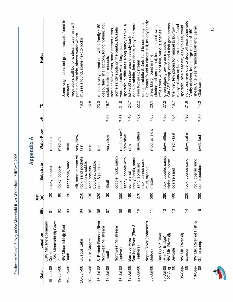
Ap
pe
nd
ix A
Date
Location
Site
Dist.
(m)
Substrate
Water Flow
pH
oC
Notes
19-Jun-08 LSW Mir. Metepenagiag
Center
01
120 rocky, cobble
medium
19-Jun-08 LSW Miramichi @ Cave
In
02
80 rocky, cobble
medium
19-Jun-08 NW Miramichi @ Red
Bank
03
20 sandstone, sand
slow
Some vegetation, eel grass, mussels found in
clusters
20-Jun-08 Guagus Lake
04
250 silt, sand, stream w/
rock, sand pockets
very slow,
fast
16.9
vegetation, soft bottom, stream was fast with
pools on the side, slower water where
mussels found, some next to rocks
20-Jun-08 Mullin Stream
05
130 boulders, cobble,
sand pockets
fast
16.8
16-Jul-08 S. Branch Renous River
06
320 boulders, cobble,
sand & pebbles
fast
23.3 mussels very spread out, with 1 family ~ 80
18-Jul-08 Northwest Millstream
(mouth)
07
30 Shall
very slow
7.66
19.7 deep, dark, shall bottom, found nothing, not
suitable site for mussels
18-Jul-08 Northwest Millstream
(upriver)
08
300 cobble, rock, sandy
pockets
medium-swift
7.68
21.8
some shallow areas, some deeper areas,
some sandy spots on the banks. Mussels
were sporadic with 1 large cluster
18-Jul-08 Barnaby River
09
180 sandy, cobble with
some shall
Very slow,
riffle
7.40
24.7 sporadic in riffle area along sandy banks, a
lot ~300 in slow area on sandy bank
22-Jul-08 Bartibog River (Fins &
Feathers)
10
270 rocky (shall), some
sand, some silt
slow, riffles
7.62
22.2 deep in middle, lots of shells, may find more
alive further upstream
30-Jul-08 Napan River (Johnson's
Bridge)
11
500
rock, coarse sand,
mud, organic
matter
mod. w/ slow
7.63
20.1
deep in middle & dark, hard to see, easy stir
up. Floater found in almost still, muddy/sandy
area. Margi found in riffle
30-Jul-08 Bay Du Vin River
(Rte.11 Bridge)
12
280 rock, cobble, sandy slow, riffles
7.80
27.2
cluster and spread out, found in shallower,
riffle areas. A lot of fish, various species,
green algae growing on mussels
27-Aug-
08 NW Mir. River @
Sevogle
13
400 slabs, rock, some
coarse sand
med. - fast
7.64
16.7 Old ASF camp, once had a fish gate across
the river, few places for mussel to burrow
05-Sep-
08 NW Mir. River @
Exmoor
14
220 rock, coarse sand
slow, calm
7.90
21.6
many mittons on banks, live mussels found
sporadic, nice clear day easy to see, could
not cross river due to drop off near other side
10-Sep-
08 NW Mir. River @ Fish &
Game camp
15
200 rock, coarse sand,
some boulders
swift, fast
7.80
14.2
Varity of sizes, found large mitton of 150
shells. Site was Miramichi Fish and Game
Club camp


![Mitigation Site Freshwater Mussels · [Freshwater Mussel Mitigation Site Report] [December 2010] 5 Potential Mussel Mitigation Opportunity Summary Table The following table summarizes](https://static.fdocuments.in/doc/165x107/601c682255c44875853dcff2/mitigation-site-freshwater-mussels-freshwater-mussel-mitigation-site-report-december.jpg)
