Assessment of Freshwater Mussel Communities of Small ...
63
Cleveland State University Cleveland State University EngagedScholarship@CSU EngagedScholarship@CSU ETD Archive 2013 Assessment of Freshwater Mussel Communities of Small Stream Assessment of Freshwater Mussel Communities of Small Stream Mouths Along Lake Erie Mouths Along Lake Erie Trevor J. Prescott Cleveland State University Follow this and additional works at: https://engagedscholarship.csuohio.edu/etdarchive Part of the Environmental Sciences Commons How does access to this work benefit you? Let us know! How does access to this work benefit you? Let us know! Recommended Citation Recommended Citation Prescott, Trevor J., "Assessment of Freshwater Mussel Communities of Small Stream Mouths Along Lake Erie" (2013). ETD Archive. 809. https://engagedscholarship.csuohio.edu/etdarchive/809 This Thesis is brought to you for free and open access by EngagedScholarship@CSU. It has been accepted for inclusion in ETD Archive by an authorized administrator of EngagedScholarship@CSU. For more information, please contact [email protected].
Transcript of Assessment of Freshwater Mussel Communities of Small ...

Cleveland State University Cleveland State University
EngagedScholarship@CSU EngagedScholarship@CSU
ETD Archive
2013
Assessment of Freshwater Mussel Communities of Small Stream Assessment of Freshwater Mussel Communities of Small Stream
Mouths Along Lake Erie Mouths Along Lake Erie
Trevor J. Prescott Cleveland State University
Follow this and additional works at: https://engagedscholarship.csuohio.edu/etdarchive
Part of the Environmental Sciences Commons
How does access to this work benefit you? Let us know! How does access to this work benefit you? Let us know!
Recommended Citation Recommended Citation Prescott, Trevor J., "Assessment of Freshwater Mussel Communities of Small Stream Mouths Along Lake Erie" (2013). ETD Archive. 809. https://engagedscholarship.csuohio.edu/etdarchive/809
This Thesis is brought to you for free and open access by EngagedScholarship@CSU. It has been accepted for inclusion in ETD Archive by an authorized administrator of EngagedScholarship@CSU. For more information, please contact [email protected].

ASSESSMENT OF FRESHWATER MUSSEL COMMUNITIES OF SMALL STREAM
MOUTHS ALONG LAKE ERIE
TREVOR J. PRESCOTT
Bachelor of Science in Biology
Baldwin Wallace University
May 2008
Submitted in partial fulfillment for requirements of the degree of
MASTER OF SCIENCE IN BIOLOGY
at the
CLEVELAND STATE UNIVERSITY
December 2013

We hereby approve this thesis of
Trevor J. Prescott
Candidate for the Master of Science in Biology degree for the
Department of Biological, Geological & Environmental Sciences
and the CLEVELAND STATE UNIVERSITY
College of Graduate Studies
______________________________________________________Date:_____________
Dr. Robert A. Krebs, BGES/CSU
Advisor
______________________________________________________Date:_____________
Dr. Wentworth B. Clapham BGES/CSU
Advisory Committee Member
______________________________________________________Date:_____________
Dr. F. Paul Doerder BGES/CSU
Advisory Committee Member
______________________________________________________Date:_____________
Dr. Fasong Yuan BGES/CSU
Advisory Committee Member
Student’s Date of Defense: December 2nd
, 2013

ACKNOWLEDGEMENTS
First and foremost, I would like to thank my committee for their input and
guidance throughout my time as a graduate student at Cleveland State University. Dr.
Robert Krebs exhibited an incredible amount of wisdom and patience while mentoring
and guiding me through the program. Dr. Pete Clapham helped me to solve countless
issues with the remote sensing portion of my research. Dr. Paul Doerder was a source of
invaluable advice regarding the graduate student experience, as well as life in general. Dr.
Fasong Yuan helped me to broaden my perspective on my project, thus opening my mind
to topics that had previously not occurred to me. I couldn’t have produced this project
without these professors.
I would like to express my appreciation to the Lake Erie Protection Fund for
providing financial support for the equipment and staff involved the river mouth surveys.
I would like to thank Dr. David Klarer and the staff at the Old Woman Creek State
Nature Preserve for chemically analyzing the water samples taken, as well as providing
lodging during the river mouth surveys.
Finally, I would like to thank the department of Biological, Geological, and
Environmental Sciences accepting me into the Masters of Science program and for
allowing me to be a teaching assistant. Being a graduate student is an incredible
experience and I believe that it encouraged me to become a better biologist.

iv
ASSESSMENT OF FRESHWATER MUSSEL COMMUNITIES OF SMALL STREAM
MOUTHS ALONG LAKE ERIE
TREVOR J. PRESCOTT
ABSTRACT
Invasion of lakes and rivers by dreissenid mussels pushed out native species,
particularly freshwater mussels in the Unionidae, across the northern hemisphere, and
perhaps most infamously, within the Laurentian Great Lakes. However, several coastal
areas along the shallowest of these lakes, Lake Erie, may be refugia for native species,
but the conditions under which native species persist are unknown. I surveyed river
mouths of small streams along the Lake Erie coastline and compared species abundance
to land use assessed by remote sensing techniques and to standard measures of water
chemistry. Sampling focused on stream zones influenced by lake-water levels for three
streams each in the western and central basins of Lake Erie and in Sandusky Bay. Eight
of the nine streams possessed mussels: Pyganodon grandis (7 streams), Toxolasma
parvum (5 streams), Quadrula quadrula (5 streams), Lasmigona complanata (5 streams),
Leptodea fragilis (4 streams), and Utterbackia imbecillus (2 streams), while Amblema
plicata, Obliquaria reflexa and Uniomerus tetralasmus were found each in only one
stream. Distinct bathymetric features did not affect diversity levels, although water
chemistry may have reduced abundance in some streams and unionid abundance was
positively correlated with turbidity. Regional land use altered species dominance, as
streams within physiographic regions containing higher amounts of silt were dominated
by Q. quadrula, while more mixed habitat was dominated by P. grandis. Because, river
mouths are refugia for unionid mussels, these areas must return to or come under

v
regulatory control to monitor habitat alteration, a process stopped in this region following
the belief that dreissenid mussels had eradicated all species of interest.

vi
TABLE OF CONTENTS
ABSTRACT…………………………………………………………………………...…iv
LIST OF TABLES……………………………………………………………………...viii
LIST OF FIGURES…………………………………………………………………........ix
CHAPTER
I. INTRODUCTION……….………………………………………….....…1
II. MATERIALS & METHODS……….……….…………………………..14
2.1 River Mouth Surveys....……...……………………………................15
2.2 Water Sampling…………………...………………………................16
2.3 Statistics………...……………….……………………………...........17
2.4 Imaging Methods …………………..…………………..……………18
III. RESULTS…………...………………….…………………………………....20
3.1 Western Basin of Lake Erie………………………………………….23
3.2 Sandusky Bay Region………..……………………………………....25
3.3 Central Basin…………………………………………………………27
3.4 Beach Surveys……..……………..…………………………………..30
3.5 Watershed Land Use/Cover Analysis……………….……………….30
3.6 Water Chemistry…….……………..………………………………...31
3.7 Statistics…………………………...…………………………………31
IV. DISCUSSION…………...……………………………………....…………...34
V. CONCLUSIONS…………….…………………………………….………….43
5.1 Western Basin Streams……………………………………………....43
5.2 Sandusky Bay Streams…………………………………....…………44

vii
5.3 Central Basin Streams………………………………………………..45
LITERATURE CITED………………………………………………………….……….47

viii
LIST OF TABLES
Table 1. Unionids historically found in western Lake Erie since 1930…………….……11
Table 2. Mussels found (live/shells) within the survey region from West to East….…...18
Table 3. Averaged water chemistry results………………………………………….…...19
Table 4. Summary of shells found on beach sites…………………………………….….26
Table 5. Results from ANOVA………………………………………………………….28
Table 6. Average Water Temperature of Lake Erie’s Western Basin by Month…….......38

ix
LIST OF FIGURES
Figure 1. Locations of nearshore sampling sites in Crail et al. 2011………………….…..9
Figure 2. Locations of open water sampling sites used in 1961, 1972, 1982, and 1991...12
Figure 3. Illustration depicting streams surveyed………………………………………..13
Figure 4. Mussel rakes…………………………………………………………………...14
Figure 5. A-C. Watershed maps and pie charts depicting land use……………….......…32

1
CHAPTER I
INTRODUCTION
Freshwater mussels in North America (Bivalvia : Unionidae) have been identified
as one of the most jeopardized taxa on the continent (Williams et al. 1993). The
Cumberland and Tennessee River systems in the American southeast, are historically
known habitats for diverse unionid assemblages and once supported upwards of 87
species of native freshwater mussels. By the early 1990’s 48 of those unionid species
were considered imperiled (Williams et al. 1993). Much of the decline in diversity and
abundance of freshwater biota, including mollusks, has been attributed to
anthropogenically induced factors such as overexploitation, water pollution, flow
modification, destruction and degradation of habitat, and the introduction of exotic
species (Dudgeon et al. 2006, Haag 2012). Elsewhere in North America on the northern
distributional fringe of unionids in the midwest, many of the species that formerly
inhabited Lake Erie have been extirpated (Schloesser and Nalepa 1994).

2
The life-cycle of unionid mussels as well as their ecological niche are each critical
starting points for understanding why this group of invertebrates is declining in
abundance, diversity, and distribution (Haag 2012). In their larval form, unionid mussels
are parasitic, while adult unionids are free-living, benthic dwelling filter feeders that
ingest water through siphons. Once ingested, the water is filtered for algae, bacteria, and
other organic particles. Conception of a unionid mussel begins with the release of
spermatozoa by males into the water column. After freely floating, and with some luck
the male gemetes will be taken in my female unionid’s incurrent siphon. In the female
unionid’s gills the spermatozoa will fertilize eggs in the gills. When matured into
glochidia, the next generation of mussels will be ejected through the excurrent siphon of
a female (Haag 2012). Once in the water column, larval unionids may meet several fates:
they may come into contact with a suitable host organism, be consumed by a predator, or
die from the lack of host attachment. Depending on the species, glochidia can survive
anywhere from hours to days before either attaching to a suitable host or perishing from
lack of nutrition input (Zimmerman and Neves 2002). For example, specific
glycoproteins such as fibrinogen are thought to be important macromolecules used during
glochidia maturation and are suspected to trigger the metamorphosis of the glochidia into
a cyst that remains attached to the host until as a juvenile mussel, it detaches from the
host (Henley and Neves 2001).
Most commonly unionids are obligate parasites using fish as their host organisms.
Some unionids accept a variety of fish hosts, while others are only able to use one. For
example, Toxolasma parvum (common name: lilliput) uses Lepomis cyanellus (common
name: green sunfish) as its only host (Graf 2002), while Quadrula cylindrica (common

3
name: rabbit’s foot) uses several species from the family Cyprinidae (Graf 2002). One
species attaches to amphibians instead of fish, Simpsonaias ambigua uses Necturus
maculosus (mudpuppy) as its host. To attaract these hosts, some adult unionids have
elaborate lures protruding from their mantle. These lures draw host-appropriate fish close
to the mussel to increase the likelihood of attachment by glochidia. Glochidia will attach
to a host based on its own morphology. Typically, hooked glochidia may attach to gills,
fins, or scales, while those without hooks will attach to gills (Bauer 1994). The
morphology of glochidia differs by sub-family. The Anodontinae produce glochidia with
hooks, while members of Ambleminae have no hooks (David and Fuller 1981).
Migration of unionids is largely, if not entirely, based on the movement of their
hosts. Fish commonly move up and down streams, as well as into and out of lakes via
river mouths; although movement may be limited (Borden 2009) due to lack physical
connectivity from anthropogenic means such as dams or impediments, or from natural
fragmentation caused by ephemeral river mouths that may be open or closed depending
on water level (Zwick 1992). As a result of the migratory behavior of fish hosts,
glochidia are able to “hitch a ride” against currents to later drop off of the host fish
upstream, where they will complete their life cycle as adult mussels. The “drop-off” point
for juvenile mussels is important for determining unionid distribution because adult
unionids are functionally sedentary. Adults have a limited capability to migrate
horizonitally and vertically within the benthos, but they do not cover great distances and
the stimulus for moving is commonly temperature during winter and summer in some
areas (Allen and Vaughn 2009). Substrate quality and nutrient availability around that
point are two of many possible factors that influence the likelihood of unionid

4
colonization. Using only a muscular foot, freshwater mussels are likely limited by the
substrate. Unionids generally inhabit areas with a soft substrate, one that is primarily sand
or silt.
The life histories and niches of two particular invasive species, or one exotic
genus, have greatly changed the distribution of unionid mussels. In the mid 1980’s,
Dreissena polymorpha (zebra mussel), and Dreissena bugensis (quagga mussel)
(Bivalvia : Dreissenidae) were introduced into the Great Lakes via the ballast of shipping
barges (Herbert et al, 1989). Dreissenids are filter-feeders in lentic environments, and
their larvae are veligers, which are free-living throughout this portion of their life-cycle.
They do not attach to a fish to move upstream, nor can they move against a current.
Dreissenid adult forms fit the strict definition of sedentary; they rarely move once
attached to a hard substrate using their byssal threads. There are a wide variety of
materials suitable for attachment. Dreissenids have been observed colonizing
allochthonous input such as wood, concrete, and discarded tires. They also attach to
biotic surfaces like the submerged portion of Phragmities australis, unionid mussels,
discarded unionid shells, and other dreissenids (Lancioni and Gaino 2006). Dreissenid
affinity for attaching to unionids is a leading cause for the extirpation of many native
mussel species from the lake. The lattermost substrate makes it possible for these
invasive mussels to colonize areas of soft substrate such as sand by stacking on top of
discarded and deceased dressenids. One individual may attach to a grain of sand, and on
top this one individual many more will attach.
Dreissenids have preferences for sites of attachment. Veliger larvae seem to prefer
horizontal surfaces, the underside of artificial substrates as opposed to sunlit upper

5
surface, and non-toxic elements thus avoiding copper, brass, and iron (Lancioni and
Gaino 2006). Dreissenid mussels will also not colonize silt, but will readily attach to the
shell of unionid mussels in a silty benthos. These exotic mussels were first detected in the
Great Lakes in 1986 and their impact was pronounced by the early to mid 1990’s due to
studies describing the loss of unionids in Lake Erie (Table 1) (Nalepa et al. 1991,
Schloesser and Nalepa 1994). As a result of these life-history qualities and substrate
preferences, dreissenids rely on anthropogenic means of movement and water current to
be dispersed through water bodies (Lancioni and Gaino 2006, Karatayev 1998).
At one time, Lake Erie supported millions of unionid mussels (Wood 1953) and
before the mid 1980’s, as many as 47 species once made this lake and its tributaries home
(Strayer and Jirka 1997, Graf 2002). Lake Erie possesses several traits that make it
excellent mussel habitat. This lake is eutrophic and the increased nutrient concentration,
along with the warm temperature in Lake Erie’s western basin may be the basis for the
diverse food web within that part of the lake, which includes many types of fish and algae
(Sprules 2008). Lake Erie’s substrate is generally very soft and silty with scattered sand
bars (Herdendorf 1987); this variation in substrates allows for suitable burrowing habitat
for many lotic species of unionid (Haag 2012).
In lentic and very slowly moving lotic habitats, dreissenid mussels found a niche
incorporating unionids as a substrate (Herbert et al 1989). Unionid shells provide a stable
and hard location for attachment, which aided the dreissenids in becoming established in
Lake Erie; much of the substrate away from the shoreline is very soft and unstable. Also,
dreissenid mussels were able to enhance their filter feeding, because in close proximity to
a dreissenid’s point of attachment lies the incurrent siphon of unionids, which constantly

6
draws in water. Dreissenids tap into the incurrent flow created by the “substrate unionid”
using their own incurrent siphon to more easily ingest particulate matter. Commonly,
many dreissenids attach to one unionid contributing to death by starvation for the
unionid. This almost parasitic behavior is thought to be the main factor that eliminated
many unionid species from Lake Erie (Baker and Levinton, 2003).
Unionids are an indicator of water quality due to their filter feeding behavior and
sensitivity to contaminants. Unionid mussels are for the most part at the mercy of their
surroundings in regard to nutrition and health. Water pollution is considered to be one of
the leading factors contributing to unionid decline (Strayer 2004), and although there is a
gradient for pollution tolerance within Mollusca (Ortman 1917); generally speaking no
unionids can survive in heavily polluted water. Living unionids are also proof of a
healthy stream; more diverse and larger mussel communities are usually indicative of
higher water quality in streams and lakes (Gangloff et al. 2009; Augspurger et al. 2003;
Pip 2006).
Unionids display a wide range of pollution tolerance depending on the species,
stage in the life-cycle, and type of pollutant. Glochidia and juvenile mussels may be more
susceptible to poisoning via pollution than adults, as adults are adept at sequestering
heavy metals (Waykar and Shine 2011), leading to the belief that current water quality
regulations may not protect the younger life-stages of unionids (Wang 2007, 2009). A
recent study in Ontario, Canada reported that chloride reaches levels that are acutely toxic
to Lampsilis faciola glochida (Gillis 2011). Glochida may also be more sensitive towards
monochloramine, a chemical formed when chloride and certain types of ammonia
interact, typically downstream from wastewater flows (Goudreau et al. 1993). Metals

7
such as lead, zinc, and copper are thought to reduce fitness of glochidia and are known to
increase mortality (Kovats et al. 2010).
Unionids themselves exert feedback on their habitat. They aid in nutrient cycling
(Newton at al. 2011). Many organisms rely on unionids for the release of nutrients into
the water column, as the availability of nutrients often triggers production across trophic
levels and increases the abundance of benthic invertebrates (Spooner 2006; Greenwood et
al. 2001). Unionids cycle nutrients in two ways. They break down organic compounds
filtered out from the water column as well as expel wastes that act as fertilizer (useful
ammonia, organic nitrogen) for aquatic macrophytes such as algae, and as food for
invertebrate scavengers (Davis, Christian and Berg 2000; Vaughn et al, 2008). Mussel
waste products commonly are bacterially active and contain substantial amounts of
useable carbon and phosphorus (Giles and Pilditch 2006). Unionids also physically
disturb the benthos when moving, which causes nutrients (silicon, nitrogen, phosphorus)
locked up in benthic sediment to be released into the water (Newton et al, 2011).
Furthermore, discarded unionid shells add to the benthos because they can be used as
shelter and perhaps even as a nesting area, as I observed for Neogobius melanostomus,
the invasive round goby. The ability to cycle nutrients depends on biomass; larger
mussels recycle more nutrients. The same idea applies to mussel community size; mussel
beds with more individuals will cycle more nutrients than those with few individuals
(Strayer 1991). If unionid abundance is declining across North America, it stands to
reason that freshwater communities and ecosystems with a historical unionid component
may deteriorate in diversity, and their ability to perform ecosystem services.

8
Land use and cover affect a stream by altering inputs and community structure
(Tong and Chen 2001). Such watershed attributes can be drivers of a healthy stream
ecosystem by regulating abundance and diversity of flora and fauna within that stream
(Schloesser 1991). Mussels are greatly affected by the composition and temperature of
surface water runoff; anthropogenic disturbance via pollution and change in land use
within a watershed can greatly disturb unionid communities (Brown and Daniel, 2010).
Runoff is usually warmed as it travels overland, especially in areas of low vegetation and
high impervious surface. Tiled agricultural fields may also have a similar effect in
warming runoff as they drain rapidly. Poole and Downing (2004) found that as the
percent of agricultural land use in Iowa watersheds increased, species richness decreased.
Rural areas typically add nutrients such as nitrogen and phosphorus containing
compounds as well as sediment, and these areas also may harbor a fish community
different than that of an urbanized area (Alexandre et al 2010; Arlinghaus et al. 2008;
Lewis et al. 2007). Rural and forest watersheds will possess cyprinids (minnows) and
other bethic-feeding species (Long and Shorr 2005). Urbanized areas are usually more
severely impacted than rural systems (Lyons et al. 2007) and are generally characterized
by the presence of centrarchids (sunfish) and other pollution tolerant taxa (Long and
Shorr 2005). Urbanized areas will tend to add heavy metals, sodium, chloride and sulfate;
impervious surface may also play a part in unionid distribution by allowing more of these
urban pollutants direct access to streams (Tong and Chen 2001). By consequence,
unionid extirpation rates in the southeastern United States (Gillis et al. 2011) as well as
around Lake Erie (Krebs et al. 2010) are highest around cities and suburbs.

9
Land use types with vegetation coverage can modify properties of the runoff such
as hydrologic cycle, chemistry and temperature. One example of a heavily vegetated land
use type is the riparian zone which has the ability to moderate many aspects of a stream
such as temperature, water composition and overall stream morphology (LeBlanc et al.
1997). A less vegetated land cover will decrease filtration rate and moisture retention of
the soil, as well as possibly increase sediment loads in-stream and concentration of
nitrogen and phosphorus based nutrients (Groffman et al. 2003). Unionids are also
affected by changes in stream morphology; they commonly aggregate in area of less
flooding and substrate scouring (Strayer 1999; Johnson and Brown 2000). Streams
characterized by incised channels and unstable sand or unconsolidated gravel substratum
will typically support few mussels (Brown and Curole 1997).

10
Figure 1. Locations of nearshore sampling sites in Crail et al. 2011. Squares denote sites
with fresh dead found, circles represent wetland sites where live specimens were
found, and Stars symbolize sites where live mussels were found in the lake.
Despite the abundance of research on mussel communities in lakes and rivers,
little information is available concerning the distribution of unionids within the interfaces
between rivers and lakes, often called (freshwater) estuaries, or drowned river mouths.
Although most species of unionids were extirpated from the open water portion of
western Lake Erie, several areas of coastal refuge were identified in the late 1990’s and
early 2000’s. In Ohio, Metzger’s Marsh and Crane Creek were two well documented
refuges (Nichols and Wilcox, 1997; Nichols and Amberg, 1999; Bowers and de Szalay,
2004), and coastal refuges were later discovered on Presque Isla, PA (Schloesser et. al.,
1997; Schloesser and Mateller, 1999) and in the St. Clair river delta (Zanatta et al., 2002).

11
Coastal area like these may be refugia for the remaining mussels (Crail et al 2011), and
the discovery of these coastal unionid refuges has spurred greater exploration into other
areas along the shore of Lake Erie. Without more information concerning the distribution
of unionids within river mouths and marshes, it is unknown whether such refuges are
isolated aberrations or are part of a greater pattern of unionid distribution.
Given this question, timed haphazard (semi-quantitative) surveys were conducted
in nine additional streams of northwest Ohio that had not been previously studied for
mussels. These streams encompassed six watersheds, and each watershed was assessed
using remote sensing software to classify and quantify land use and cover types within its
borders. These results were used along with water chemistry analysis collected twice over
two field seasons, in order to identify what physical features might support or limit
communities of unionids in flooded river mouths.

12
Table 1. Unionids historically found in western Lake Erie since 1930. X’s represent live
unionids collected. O’s represent no live specimen collected.
Species Open Water Sites Resampled Open Water Sites Nearshore Sites
1930-1982 1991 1996 - Present
Amblema plicata X O X
Elliptio dilatata X O X
Fusconaia flava X O X
Lampsilis cardium X O X
Lampsilis siliquoidea X O X
Lasmigona complanata O O X
Leptodea fragilis X O X
Ligumia nasuta X O O
Obliquaria reflexa X O X
Obovaria subrotunda X O X
Pleurobema sintoxia X O X
Potamilus alatus X O X
Pyganodon grandis X O X
Quadrula pustulosa X O X
Quadrula quadrula O O X
Strophitus undulates X O X
Toxolasma parvum O O X
Truncilla donaciformis X O X
Truncilla truncate X O X
Uniomerus tetralasmus O O X
Utterbackia imbecillis O O X
Records for this table were obtained from numerous past surveys of the western
basin of Lake Erie; 1930 (Wright 1955), 1951-52 (Wood 1963), 1961 (Carr and Hiltunen
1965), 1972 (Roth and Mozley unpublished), 1973-74 (Wood and Fink 1984), 1982
(Manny et al. unpublished). The 1991 data derived from Schloesser and Nalepa (1994).
Nearshore data are derived from more recent surveys Crane Creek in 2001 (Bowers and
De Szalay 2004), and in Metger’s Marsh in 1996 (Nichols and Wilcox 1997) and recent
shoreline studies (Crail et al. 2011).

13
Figure 2. Locations of open water sampling sites used in 1961, 1972, 1982, and
1991(From Nalepa et al. 1991). Data from these sites were used in Table 1.

14
CHAPTER II
MATERIALS & METHODS
The area of study consisted of three regions of Lake Erie along northwest Ohio’s
coast (Figure 3). The streams surveyed that drain into Lake Erie’s western basin were
Cedar Creek, Turtle Creek, and Toussaint Creek. Streams that drained into Sandusky Bay
were Yellow Swale, South Creek, and Raccoon Creek. Those draining into Lake Erie’s
central basin were Plum Brook, Cranberry Creek, and Chappel Creek. Beaches (Figure
3.) were surveyed in addition to the streams to assess whether the vouchers found on the
shore were similar to specimens present in near-bye river mouths.

15
Figure 3. Illustration depicting streams surveyed and the sites examined closest to the
lake. Stars signify streams while squares represent beaches surveyed.
2.1 River Mouth Survey Methods
Timed surveys were conducted between June and August of 2010 using mussel
rakes (Figure 4) for a minimum of 4 person hours per stream. These surveys were semi-
quantitative or “haphazard” in that individuals acting as surveyors did not follow any
particular pattern when raking the benthos, but often intensified searching within an area
once a live mussel was found. The haphazard technique was the most time-effective
strategy due to its ability to first locate mussel patches given the patchy nature common
to mussel distributions as well as the lack of any historical information concerning
unionid presence in these small streams. Rakes were advantageous compared to typical
tactile searches using hands and feet because they allowed for surveying in deeper water

16
without the use of breathing equipment. Also the rakes were able to collect small
individuals such as Toxolasma parvum, and juvenile unionids that could easily be missed
when employing a traditional tactile search. All mussels were identified to species on-
site. Live specimens were recorded and placed back into the stream, while voucher
specimens (empty shells and valves) were collected and catalogued at Cleveland State
University.
Figure 4. Mussel rakes made from standard bow rakes bought at a consumer hardware
store. The basket of the rake was made from 1 cm squared galvanized steel mesh
which was wrapped to form a basket. Side panels for the basket portion were cut
out using metal shears and all parts were assembled to the rake using 16 gauge
steel wire.
2.2 Water Sampling Methods
Each stream was sampled using an apparatus made from a 1 liter bottle with a
mouth diameter of 2 centimeters attached using duct tape to a 2.5 meter segment of iron
rebar. Sampling typically took place from a low hanging bridge that ran perpendicular to

17
the stream. In cases where sampling from a bridge was not possible, the sampling
apparatus was dipped from the bank of the stream. All samples were taken from the water
column approximately 50 centimeters below the surface. After being filled, each
sampling bottle was immediately screw-capped and stored in a cooler until they were
delivered to David Klarer at the Old Woman Creek National Estuarine Reserve. Streams
were sampled twice, once each in the summers of 2010 and 2011, and each sampling
took place during a period of drought in the region and low flow within the streams.
2.3 Statistical Methods
Shannon diversity (H) between regions among streams was assessed using PAST
ver 1.96 (Hammer et al. 2001) to conduct a pairwise t-test as well an ANOVA. Water
chemistry results were analyzed in SAS using both Pearson and Spearman rank
Correlation Coefficient tests as well as general linear regression models (GLM).
2.4 Imaging Methods
Data Sources & Software: Aerial orthophotographs (1 meter/pixel, CIR, MrSid
format) and LIDAR (1 meter/pixel, LAS format) tiles were derived in 2006 and supplied
by the Ohio Geographically References Information Program (OGRIP) and its Ohio
Statewide Imagery Program (OSIP). Shapefiles produced by the United State Department
of Agriculture’s (USDA) Natural Resource Conservation Service (NRCS) were used to
derive watershed maps. Software packages used during image processing included
ERDAS Imagine 2011 (Intergraph), eCognition 8 Developer (Trimble), and Quick
Terrain Modeler (Applied Imagery).

18
Orthophotos for all counties containing a portion of the watershed(s) of interest
were processed into a mosaic using the Mosaic Pro tool in ERDAS Imagine. A state-wide
shapefile of Ohio’s watersheds was then placed as the top layer over the mosaic aerial
image. Next, watersheds were subset from the mosaic aerial image. Watershed polygons
in a shapefile containing streams surveyed were selected within Imagine’s viewer and
copied. This process saved the shape (perimeter) of the watershed, and then using the
“paste from selected object” option created an area of interest (AOI). Each AOI
represented the outline of a watershed. Aerial photos of each watershed were clipped
from the mosaic aerial image by using the “subset” dialogue under the raster tab of
Imagine.
Lidar data were processed for all counties that contained a portion of any stream
surveyed in Quick Terrain Modeler (QT modeler.) This processing consisted of deriving
digital elevation models (DEM) and digital surface models (DSM). Subtracting the DEM
from the DSM created a normalized digital surface model (NDSM), as this can give the
height of an object above ground elevation. The NDSMs for each county were subset
with the previously mentioned aerial photograph watershed AOIs in order to yield NDSM
for each watershed. Using Imagine, the 3-band aerial orthophotograph, and the LIDAR
data for each watershed was loaded and layer-stacked in order to form one final image
per watershed (4 bands: near infrared, blue, green, and LIDAR).
Finally, each watershed image was classified using eCognition. This was done by
using the multispectral segmentation protocol, and classifications were based on samples
chosen for each type of land-use category. Image layers were weighted as follows: near

19
infrared 1, blue 1, green 1, and LiDAR 2. This action enabled LIDAR to be a greater
influence on the classifications than near infrared, blue, and green. Furthermore, the scale
parameter was set to 20, shape to 0.3, and compactness to 0.7. These settings allowed for
pixels of similar shape and color to be grouped together into objects, which allowed
classification to be less time consuming. Then, a spectral difference segmentation (set to
2) was run to group chromatically similar image objects.

20
CHAPTER III
RESULTS
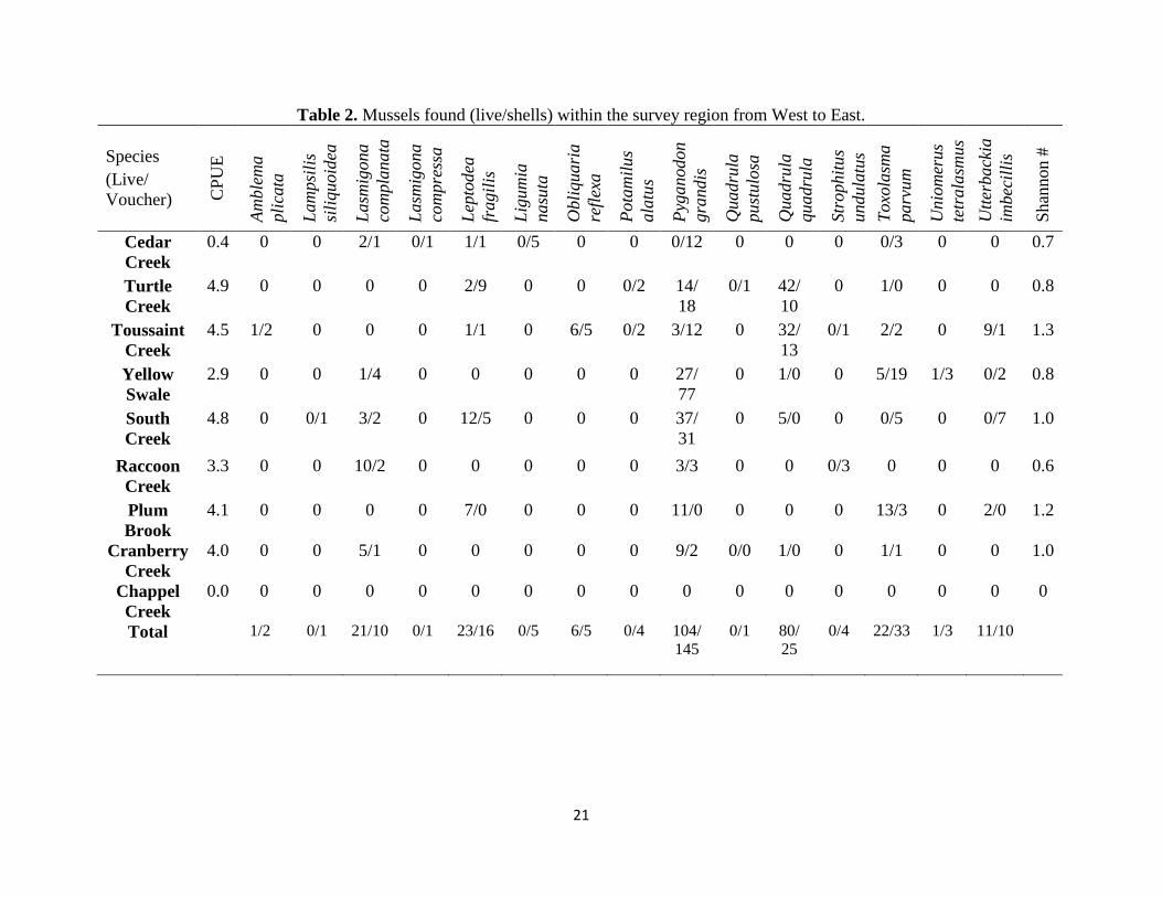
Nine unionid species were identified as living in eight streams (Table 2). In order
of abundance these species were Pyganodon grandis, Quadrula quadrula, Toxolasma
parvum, Leptodea fragilis, Lasmigona complanta, Utterbackia imbecillis, Obliquaria
reflexa, Uniomerus tetralasmus, and Amblema plicata. An additional five species were
only identified from shells: Lampsilis siliquoidea, Lasmigona compressa, Ligumia
nasuta, Potamilus alatus, and Strophitus undulatus.
21
Table 2. Mussels found (live/shells) within the survey region from West to East.
Species
(Live/
Voucher)
CP
UE
Am
ble
ma
pli
cata
Lam
psi
lis
sili
quoid
ea
Lasm
igona
com
pla
nata
Lasm
igona
com
pre
ssa
Lep
todea
fragil
is
Lig
um
ia
nasu
ta
Obli
quari
a
refl
exa
Pota
mil
us
ala
tus
Pyg
anodon
gra
ndis
Quadru
la
pust
ulo
sa
Quadru
la
quadru
la
Str
op
hit
us
undula
tus
Toxo
lasm
a
parv
um
Unio
mer
us
tetr
ala
smus
Utt
erback
ia
imbec
illi
s
Shan
non #
Cedar
Creek
0.4 0 0 2/1 0/1 1/1 0/5 0 0 0/12 0 0 0 0/3 0 0 0.7
Turtle
Creek
4.9 0 0 0 0 2/9 0 0 0/2 14/
18
0/1 42/
10
0 1/0 0 0 0.8
Toussaint
Creek
4.5 1/2 0 0 0 1/1 0 6/5 0/2 3/12 0 32/
13
0/1 2/2 0 9/1 1.3
Yellow
Swale
2.9 0 0 1/4 0 0 0 0 0 27/
77
0 1/0 0 5/19 1/3 0/2 0.8
South
Creek
4.8 0 0/1 3/2 0 12/5 0 0 0 37/
31
0 5/0 0 0/5 0 0/7 1.0
Raccoon
Creek
3.3 0 0 10/2 0 0 0 0 0 3/3 0 0 0/3 0 0 0 0.6
Plum
Brook
4.1 0 0 0 0 7/0 0 0 0 11/0 0 0 0 13/3 0 2/0 1.2
Cranberry
Creek
4.0 0 0 5/1 0 0 0 0 0 9/2 0/0 1/0 0 1/1 0 0 1.0
Chappel
Creek
0.0 0 0 0 0 0 0 0 0 0 0 0 0 0 0 0 0
Total 1/2 0/1 21/10 0/1 23/16 0/5 6/5 0/4 104/
145
0/1 80/
25
0/4 22/33 1/3 11/10

22
Table 3. Averaged water chemistry results taken during the summers of 2010 and 2011.
Site C
hlo
ride
Turb
idit
y
AL
K
NH
3-N
NO
2-N
NIT
RA
TE
Sil
icat
e
Sulf
ate
SR
- P
Ca
Mg
Na
K
Fe
ppm JTU ppm ppm ppb ppm ppm ppm ppb ppm ppm ppm ppm ppm
Cedar
Creek 100.7 13.5 197.8 0.01 2.3 0.57 6.4 62.5 54.4 72.3 21.7 59.5 4.0 0.3
Turtle
Creek 26.2 76.4 158.0 0.05 4.8 0.76 3.7 50.3 86.6 56.2 19.3 13.7 3.9 1.7
Toussaint
Creek 62.1 55.23 200.9 0.03 4.2 0.68 3.0 89.7 105.5 77.6 27.2 30.2 7.1 1.1
Yellow
Swale 43.0 44.8 227.6 0.07 2.6 1.3 5.3 51.3 60.9 77.8 23.9 25.1 4.7 1.2
South
Creek 44.1 37.5 208.8 0.0 0.97 1.5 3.9 688.1 30.9 257.9 53.2 27.9 4.9 2.6
Raccoon
Creek 86.6 12.4 197.8 0.01 12.45 5.5 2.9 498.1 73.9 209.8 28.3 109.4 14.3 0.4
Plum
Brook 66.9 13.12 160.3 0.01 71.70 1.3 1.9 72.9 32.6 65.5 18.2 44.1 3.5 0.4
Cranberry
Creek 40.4 14.6 147.7 0.01 25.38 5.9 2.7 42.9 635.0 59.4 17.0 24.6 10.8 0.5
Chappel
Creek 47.8 19.2 132.4 0.0 1.65 3.8 2.8 41.0 25.4 52.3 12.7 27.2 5.3 22.5
Average 57.5 31.9 181.3 0.0 14.0 2.4 3.6 177.4 122.8 103.2 24.6 40.2 6.5 3.4

23
3.1Western Basin of Lake Erie
The streams in this region all had a thin riparian zone and were most often
adjacent to farmland. Toussaint Creek and the Turtle Creek both had a similar substrate,
mainly comprised of silt. Quadrula quadrula was the most abundant species in this
region accounting for 65% of the live specimens. Each of these streams drained directly
into Lake Erie; the Cedar and the Turtle have marinas at their mouths.
Cedar Creek (41.6333, -83.3106)
The riparian zone around Cedar Creek was small. Generally a riparian zone would
stretch from about only 3 to 10 meters away from the banks of the Creek, which were
incised. This stream was also narrow, at approximately 4 meters bankfull width. Outside
of the small riparian zone lay agricultural fields. Within the stream, there were plenty of
examples of coarse particulate organic matter (CPOM) and much allochthonous input,
such as downed trees and garbage. The substrate mainly consisted of hard packed clay
and mud, along with cobble. Cedar Creek's depth when surveyed ranged from 0.66 m to
1.5 m deep.
Few mussels were present and the stream seemed degraded by erosion of the
banks. A couple of White Heelsplitters (L. complanata) and one Fragile Papershell
(Leptodea fragilis) were found well upstream from the mouth; each species is pollution
tolerant, especially the White Heelsplitter. Also 12 voucher specimens of Giant Floaters
(Pyganodon grandis) were found. The collection of 5 Ligumia nasuta shells, representing
an endangered species, led to an increased search effort, but no live individuals were
found.

24
Turtle Creek (41.6054, -83.1512)
The area surveyed was a typical flooded river mouth. This stream's surroundings
were categorized mainly as agricultural. Any riparian zone present was very thin, made
up of mostly shrubs and a few trees. However, the stream channel was very wide, much
more so than other streams surveyed, except Toussaint Creek, and the flow was slow.
The substrate was very soft and unstable.
The habitat supported a low diversity community near Lake Erie despite human
impacts. Quadrula quadrula (42) was common, followed by Pyganodon grandis (14).
Leptodea fragilis (2) and Toxolasma parvum (1) were also found.
Toussaint Creek (upstream site: 41.5783, -83.1485. downstream site: 41.5851, -
83.0681)
Surrounding land use varied from recovering riparian zone to residential and
agricultural. This river was wider than all others surveyed and the current was very slow
making the Toussaint appear like a classical flooded river mouth for several miles
upstream. Within the stream, patches of aquatic vegetation such as water lotus were
present. Different sites along this river had substrates that varied in degree of stability and
softness, and ranged from a very soft, mostly silt benthos that was approximately 30 cm
deep, to a much more stable mix consisting of less silt, but still soft with occasional
patches of sand mixed with gravel. The water depth ranged from 0.6 to 2m.
A diverse community was found in the Toussaint; seven species were found alive
and nine were found as shells. The dominant species found in soft substrates included
Quadrula quadrula (32) and Utterbackia inbecillis (9); Obliquaria reflexa (6) occurred in
one area of mixed sand and gravel.

25
3.2 Sandusky Bay Region
Several small streams enter Muddy Creek Bay which composes the western
portion of Sandusky Bay. Each is inhabited by mussels. As such, these streams near their
mouths fall within the lands protected by the Winous Point Marsh Conservancy, but the
areas surveyed which were upstream, were dominated by farmland and thin riparian
zones that may restrict habitat quality.
Yellow Swale (41.4231, -83.0338)
This stream had a wide established riparian zone consisting of older, large trees
and diverse vegetation. Outside the riparian zone were agricultural fields, wild low laying
vegetation such as wildflower fields, and residential properties. Yellow Swale's bankfull
width was less than that of Turtle Creek or Toussaint Creek, but was not incised. Flow in
this river was also slow where surveyed, 3-5 kilometers from the Sandusky River, which
then drains into Muddy Creek Bay. Yellow Swale looked like a typical flooded river
mouth influenced by lake water levels, despite entering the larger Sandusky River. This
stream has been dredged upstream of the original mouth to join the Sandusky River, and
further downstream there is a wetland which comprised the original mouth. The substrate
was soft, but not as soft as Toussaint Creek or Turtle Creek, as more sand was present in
the substrate. The water depth ranged from 0.67 m to 1.5 m where we surveyed. Yellow
Swale also possessed thick in-stream vegetation downstream.
Pyganodon grandis (27) was by far the most prevalent species found. Notably,
one live Uniomerus tetralasmus (Pondhorn) was found, along with several voucher
specimens (shells of fresh dead) of that species. One individual each of Lasmigona

26
complanata and Quadrula quadrula were found along with several Toxolasma parvum
(5).
South Creek (41.4147, -83.0083)
Despite appearing like a wide, shallow ditch, this stream had an established
healthy riparian zone downstream with residential areas outside of the riparian zone. The
substrate in-stream was muddy and soft, with perhaps a 50/50 sand/silt mix. Upstream
(south of the bridge used for access) the stream was surrounded with herbaceous
vegetation, cattails, reeds, and tall grass.
Pyganodon grandis was the prevalent species (37 live, 31 fresh dead), followed
by Leptodea fragilis (12 live, 5 dead), particularly in the upstream sandy portion of the
stream. Some Quadrula quadrula (5) were found downstream in the softer, more unstable
sediment along with Lasmigona complanata (3).
Raccoon Creek (41.4079, -82.9815)
This stream was similar to Cedar Creek in possessing incised banks, thick canopy
cover, a narrow bankful width, a substrate filled with decaying vegetation, cobble and
hard packed mud, and also abundant allochthonous input in the form of CPOM and
anthropogenic waste. This creek was surrounded by a riparian zone of varying width
ranging from several to tens of meters, to residential areas, and eventually to marsh land
towards the mouth. Unionids were found in only one spot near the route 6 bridge, in a
sandy area of deposition (70/30 mud/sand): Lasmigona complanata (10), Pyganodon
grandis (3), and as fresh dead, Strophitus undulatus.
Like Cedar Creek, the most prevalent species found was the pollution tolerant
Lasmigona complanata. Although the water in each of the areas where unionids were

27
found in Cedar and Raccoon was shallow, it appears that the larger L. complanata can
survive if the substrate is soft enough to allow burrowing and movement within sites.
3.3 Central Basin
In this region fewer unionid communities of any kind are known. Nearby, Old
Woman Creek, which is a protected preserve, has up to six species, but only Pyganodon
grandis and Utterbackia imbecillis were ever reported in many numbers. Another
protected area, Sheldon Marsh likewise has four species in low abundance (Crail et al.,
2011).
Plum Brook (41.4244, -82.6400)
Surveys in lower Plum Brook encompassed areas that are part of the Erie Co.
Metroparks. Plum Brook was wide and slow moving, much like South Creek and Yellow
Swale. Lower Plum Brook was surrounded by a large, thick, gradually sloping riparian
zone with residential properties outside of it. Plum Brook appeared to be a healthy
flooded river mouth or estuary possessing an abundant amount of aquatic vegetation
throughout the stream, and this vegetation became increasingly thicker downstream.
Plum Brook varied in substrate types: hard compact mud, soft vegetation covered mud,
and soft mud free of vegetation.
Plum Brook’s most abundant species was Toxolasma parvum (13 live individuals
and 40% of all live specimens found), followed by Pyganodon grandis (11), Leptodea
fragilis (7), and a pair of Utterbackia imbecillis. Shells were rare, and 96% of the animals
found in this stream were alive when collected. Most of these individuals, excluding T.
parvum, were juveniles.

28
Cranberry Creek (41.3813, -82.4730)
This stream was surveyed close to the lake, but on the south side of route 6 before
the stream is culverted and runs through a marina at the mouth. Surrounding types of land
use were residential and agricultural fields further upstream of the survey site and route 6.
Land fill was observed being dumped. Perhaps as a result, this stream’s substrate was
partially compact mud. The bankfull width was narrow, but wider than Raccoon or Cedar
Creeks, and the banks were slightly eroded but vegetated, mainly by small herbaceous
plants along with sparse adult trees.
Much of the collected fauna from Cranberry Creek was very young specimens of
Pyganodon grandis, Lasmigona complanata, and perhaps Leptodea fragilis. Due to the
small size of the juvenile individuals collected, identification was not conclusive.
Chappel Creek (41.3921, -82.4399)
Chappel Creek was the only stream where no unionids were found. The riparian
zone, when present, was very thin. Residential property lined the banks of the creek.
Upstream of the mouth, Chappel Creek ran adjacent to a parking lot and recreation area,
and generally, there was very little to no buffer zone to absorb and process run-off.
In-stream, Chappel Creek was unique in terms of depth and substrate, varying
greatly from several centimeters to 2 meters within a small distance (15 meters),
suggesting that this stream had been heavily altered by people in the past. The substrate
was a mixture of hard packed cobble, mud and a flaky orange silty deposition that did not
appear natural.

29
Table 4. Summary of shells found on beach sites.
Species
Lat
itude
&
Longit
ude
Am
ble
ma
pli
cata
Ell
ipti
o
dil
ata
ta
Fusc
onaia
flava
Lam
psi
lis
sili
quoid
ea
Lep
todea
fragil
is
Lig
um
ia
nasu
ta
Obli
quari
a
refl
exa
Pota
mil
us
ala
tus
Pyg
anodon
gra
ndis
Quadru
la
quadru
la
Tru
nci
lla
trunca
ta
Utt
erback
ia
imbec
illi
s
Reno
Beach
41.6
667,
-83.2
684 1 1 10 54 15 0 1 1 0 5 1 0
Potter’s
Pond
41.6
781,
-83.3
078 0 0 0 0 190 0 0 0 6 0 0 0
Turtle
Creek
41.6
152,
-83.1
314
0 0 0 0 48 0 0 0 1 1 0 1
Port
Clinton
41.5
152,
-82.9
344 3 4 0 3 98 1 1 1 0 5 1 0
Sheldon
Marsh
41.4
197,
-82.6
051 0 0 0 1 1 0 0 0 25 0 0 1
Total 4 5 10 58 352 1 2 2 32 11 2 2

30
3.4 Beach Surveys
Shells of 12 species were found during the beach surveys (Table 4): A. plicata,
Elliptio dilatata, Fuscanaia flava, L. siliquoidea, L. fragilis, L. nasuta, Obliquaria
reflexa, Potamilus alatus, P. grandis, Q. quadrula, Truncilla truncata, U imbecillis.
Beach results were mainly comprised of Leptodea fragilis (73% of fresh shells collected),
which is believed to still be in Lake Erie proper (Bryan et al. 2013). Other species were
found infrequently, and most often age could not be accurately determined due to
weathering. When a specimen was exposed to wind and surf the shell’s appearance can
degrade rapidly. Conversely, if a specimen was found buried in the sand, wind and
physical erosion of the periostracum could be hindered (Krebs and Begley 2013).
3.5Watershed Land Use/Cover Analysis
The total area for all watersheds combined was 208,340 hectares and the land
use/cover percentages across these watersheds were as follows: 72% agricultural use,
5.7% impervious surface, 14.6% natural vegetation, 0.8% water, and 7.0% of the total
area was unclassified. While all were similar, variation in land use/cover patterns existed
among watersheds (Figure 5). In comparison to the entire region, the land use and cover
for the western most watersheds (Cedar & Turtle Creeks, Toussaint Creek, Yellow
Swale, and South & Raccoon Creeks) were similar in terms of agricultural use and
naturally vegetated cover. These watersheds were composed of agricultural land use
ranging from 71% to 77%, and natural vegetation covering 9% - 14%. The two
watersheds east of Sandusky Bay that contain Plum Brook, Chappel Creek, and
Cranberry Creeks differed in their percentages of agricultural land use and naturally

31
vegetated cover: Plum Brook’s watershed was 69% farmland and 21% was naturally
vegetated, while the watershed containing Chappel Creek and Cranberry Creek used the
smallest percentage of land for agriculture (53%) and was covered by the highest
percentage natural vegetation (32%).
3.6 Water Chemistry
Water chemistry among all streams surveyed was similar with relatively few
outliers (Table 3). These observed may have impacted unionid diversity or abundance.
Cranberry Creek had an unusually high amount of soluble reactive phosphorus that was
over five times the average among all Creeks (635 ppb compared to 123 ppb). Surveys
here yielded juvenile unionids but a distinct lack of adult specimens. Several streams
were more turbid than average (31.9 JTU). These streams were Turtle Creek (76.4),
Toussaint Creek (55.23), Yellow Swale (44.8), and South Creek (37.5). Higher than
average amounts of sulfate and calcium were measured in South Creek (688.1 ppm, 257.9
ppm) and Raccoon Creek (498.1 ppm, 209.8 ppm). Chappel Creek, which yieled no
unionids during surveys, did not yield abnormal chemical results.
3.7 Statistical Results
The total number of live, whole individuals found alive in the the bethos during
surveys correlated significantly with turbidity (r=0.83, P<0.01), while other chemicals
such as nitrate could possibly have more subtle effects. A stepwise model produced an
equation as follows: Y(live) = -59.6 + 1.16 Turb + 1.14 Mg + 1.23 Fe + 0.58 NO2N +
0.21 Cl. (See table 5)

32
Table 5. Results from ANOVA
Variable Parameter
Estimate
Standard
Error
Type II SS F Value Pr > F
Intercept -59.58245 6.60227 540.31099 81.44 0.0029
Chrloride 0.21469 0.05600 97.49372 14.70 0.0313
Turbidity 1.15785 0.06442 2143.12132 323.04 0.0004
NO2-N 0.57832 0.05387 764.52781 115.24 0.0017
Magnesium 1.13927 0.08918 1082.69537 163.20 0.0010
Total Iron 1.22967 0.17049 345.11497 52.02 0.0055
A. Western Basin

33
B. Sandusky Bay
C. Central Basin
Figure 5. A-C. Color coded watershed maps and pie charts depicting land use from west
to east. Brown and Yellow were combined to form the yellow slice of each chart; each
color represents types of agricultural fields, barren and vegetated respectively. Gray roads
were also grouped with buildings to indicate impervious surface in red on the charts.

34
CHAPTER IV
DISCUSSION
Unionids use river mouths as refugia from dreissenid mussels. Quadrula quadrula
(common name : Mapleleaf) was the dominant species in Turtle Creek and Toussaint
Creek (Western basin). Each of these streams had a soft substrate mainly comprised of
silt, and were the most turbid streams sampled. Quadrula quadrula is more tolerant of
suspended solids than other unionids such as Lampsilis teres (Ellis 1936), further
enabling it to become established in a turbid, silty habitat. This type of lotic environment
is partially caused by the high proportion of agricultural land use now present to naturally
vegetated land cover in each stream’s watershed in the western basin region (Peacock et
al. 2005). Geologically, the streams that harbored greater numbers of Q. quadrula are
part of the Maumee Lake Plain, which consists mainly of silt, clay, and carbonate rock;
these three components combined with a shift to agricultural land use have helped to
create an ideal substrate for the Mapleleaf by increasing water turbidity, adding to the
unstable silt-based benthos, and buffering the pH.

35
In the Sandusky Bay and Central basin regions, Pyganodon grandis (common
name : Giant Floater) was the most commonly found species. Although the streams in the
Sandusky Bay’s region are still within the Maumee Lake Plains, the substrate in Raccoon
Creek, South Creek, and Yellow Swale contained less silt and more sand. These streams
are close to the Castalia Karst Plain (Brockman 1998) which consists of thinner layers of
silt and clay along with a greater amount of sandy deposits. This observed change in
substrate could possibly be due to a physiographic gradient between the Maumee plains
and the Castalian karst; physiographic gradients are known to affect soil properties and
vegetation (Campo-Bescós 2013) which affect stream morphology and chemistry
(LeBlanc et al. 1997). Perhaps the change in benthic composition is also partially due to
these watersheds having a higher proportion of land covered by natural vegetation. P.
grandis is a habitat generalist (Haag 2012) known to prefer small streams, lakes, soft
substrate, and also possesses a tolerance to pollution and sedimentation (Parmalee &
Bogan 1998). These traits enable Giant floaters to persist in Yellow Swale and South
Creek (third and fourth most turbid streams surveyed) because of their turbidity, sandier
benthos, and increased proportion of naturally vegetated area in their watersheds.
Pyganodon grandis was also found in Raccoon Creek (Sandusky Bay region),
which was high in chloride, magnesium, sodium, and several nitrogen containing
components. This stream contained ten Lasmigona complanataI. This species was also
found alive in other chemically disturbed streams across the survey area (Cedar Creek
and Cranberry Creek). All of the live individuals of either species were found in an area
of sandy deposition. Raccoon Creek is known to be chemically unstable and unhealthy
which may account for the low species diversity and abundance.

36
The Central Basin streams surveyed were split between two physiographic
regions, each with similar numbers of live Pyganodon grandis: Castalia Karst Plain and
Erie Lake Plain. Plum Brook lies in the karst plain, while Cranberry Creek and Chappel
Creek were part of the Erie Lake Plain region, which is comprised of silt, clay, sandstone,
and shale (Brockman 1998). Plum Brook can also be separated from the other two
streams in this region by amount of anthropogenic disturbance. Plum Brook is part of the
Erie County Metroparks and thus is surrounded by a comparably larger riparian zone; this
stream was habitat for P. grandis and a slightly greater number of Toxolasma parvum.
Cranberry Creek was channelized and culverted near the mouth, while the mouth of
Chappel Creek is now surrounded by anthropogenically sculptured land use such as
housing developments, a summer camp, and a popular public beach accompanied by
buildings. While all of the Central Basin creeks were within watersheds that consisted of
a lesser proportion of farmland to natural vegetation, chemically Plum Brook was
healthy. Cranberry Creek possessed a very large amount of soluble reactive phosphorus
(SRP), which is suspected to be the result of a manure pile upstream, and construction
equipment seen dumping landfill into the stream. Still it harbored P. grandis and L.
complanata. Oddly, no large adults of any species were found in Cranberry Creek and no
mussels were found in Chappel Creek at all, perhaps due to the disturbed stream
morphology, the high iron content of the water, hard gravel substrate, or a combination of
all three.
Furthermore, while there are no historical results for Chappel Creek to use as
comparison it is assumed that its nutrient loading is similar to near-bye Old Woman
Creek, which typically has high nutrient and sediment loads (OEPA 2005). Unlike Old

37
Woman Creek, Chappel Creek has been anthropogenically disturbed, including
movement of the mouth (David Klarer personal communication). This stream has been
impacted by crop production within the vicinity (OEPA 2005). Cedar and Raccoon
Creeks had substantially higher chloride levels than the other creeks surveyed. Raccoon
Creek has been known to harbor elevated nutrient levels downstream of Clyde, Ohio
(OEPA 2009) that would have impacted survey results. South Creek has also been
historically known for excess nutrient loading due to the access of livestock to the stream
as well as run-off from adjacent residential and agricultural areas (OEPA 2009), yet it
harbored a healthy mussel population.
Watershed geology plays a major part in composing a steam’s benthos and water
chemistry. Substrate composition relates to current velocity; a watershed showing rapid
change in elevation may face benthic scouring (Gordon et al. 1992). Physiography can
affect the composition of riparian zones near a stream, which in turn influences the
stability of the stream’s channel (Stalnaker et al. 1995). Together these features may
determine water chemistry (Web and Walling 1992; Allan 1995). Sedimentary rock such
as limestone, which is common around Lake Erie, will help to buffer the stream from
radical changes in pH. Conversely, streams upon metamorphic rock generally have
poorly buffered water and low pH. A stream can become more acidic by decaying
vegetation and other allochthonous input. As acidity rises, mussel diversity and
abundance decrease (Allan 1995). Extremely low pH is especially harmful for freshwater
bivalves. Calcium can bond with anions, and it is important for unionids to uptake
calcium ions in order to for shell growth and repair (Bogan 2001). For unionids, basic pH

38
along with moderately hard, to hard water is preferred if not essential (Zanatta et al.
unpublished)
Vegetation together with watershed size and annual rainfall will determine the
physical and hydrological stability of streams (Church 1992, Gordon et al. 1992). Some
species such as Quadrula quadrula were found in unstable sediment described as silty, in
a larger steam, with very little riparian zone area in either the Western Basin or in part of
a stream where particulate matter size is less. Toxolasma parvum was mostly found in a
stream with a stable substrate and a large riparian zone. Lowland rivers, or river mouths
containing silt and clay are usually more stable due to the bonding properties of these two
components, as oppose to sand (Krebs et al. 2010), and this may enable river mouths to
be a good habitat for generalist unionids (Church 1992; Allan 1995). However, some
sand may be beneficial to certain species like Pyganodon grandis, as it may allow for
easier burrowing; parts South Creek where many P. grandis were found exemplified the
positive aspect of sand in a mixed benthic environment.
Due to overland run-off, in addition to ground water, river mouths may exhibit
variability in flow and may be flashy. However an area with a low gradient elevation,
such as in northwest Ohio can slow run-off and become lentic. Historically, such streams
with turbid water were thought to harbor a lower abundance and diversity of mussels
(Coker 1915). However, rivers with high amounts of sediment can also harbor numerous
mussels as in Turtle Creek, Toussaint Creek, Yellow Swale, and South Creek. Size of
streams may matter less in terms of quality of mussel habitat due to the extensive
influence from the lake and watershed size (Krebs et al 2010, Crail et al. 2011).

39
Although, larger streams in agricultural areas may deposit more silt and that change coulf
shift species dominance from Pyganodon grandis to Quadrula quadrula.
There are a variety of tributaries draining into Lake Erie and the river mouths and
their connectivity to the lake has long been assumed to be providing corridors between
adjacent communities (patches) of mussels. However, thick wetlands (Yellow Swale,
Raccoon Creek, Plum Brook) or even marinas (Cedar, Turtle, Chappel, Cranberry) may
act as barriers to reduce or block dispersal for fish (Krebs et al. 2010). Even in small
streams, not all stream mouths are open all year round. Mouths can be open ephemerally,
such as at Old Woman Creek. This known mussel refuge, has a mouth that is periodically
closed off by sediment deposition until this river’s flow is strong enough to break
through. Other streams such as Plum Brook and Yellow Swale have mouths that become
highly vegetated, similar to wetlands, and fish movement may depend on periods of high
lake water levels. The mouth of South Creek leads to Muddy Creek Bay and was less
than 1 meter deep in 2011, a high-water year, but perhaps that is open enough. An
undisturbed, wide, non-vegetated, and slowly moving river mouth (South Creek,
Toussaint Creek) could allow for a greater amount of fish to enter and exit, bringing with
them more mussels.
At the shallowest levels, river mouths (in northwest Ohio) flow slowly and this
enabled lentic and riverine (lotic) species to be present in small river mouths of northwest
Ohio; Pyganodon grandis, Toxolasma parvum, and Utterbackia imbecillis were found, as
well as lotic species such as Unionmerus tetralasmus, which typically live in ponds and
slow moving streams, and Quadrula quadrula which is found in slow moving streams
with silty substrate. River mouths also make poor habitat for dreissenids: water level

40
fluctuation, ice scour, reed beds/wetlands (Bodamer and Bossenbrook 2008), and
predation by fish, crayfish, and turtles (Bowers and de Szalay 2005), can combine with
flow to oppose travel of veligers upstream.
Lake Erie exhibits great variation in terms of biotic and abiotic features, both in
the lake’s benthic and surrounding environments, possibly because it is the smallest of
the Laurentian Great Lakes in terms of maximum depth and volume (Lake Erie Lakewide
Management Plan: Annual Report 2011). Lake Erie offers a gradient in bathymetry. The
western basin is shallow, averaging approximately 10-15 meters deep, while the central
basin is slightly deeper at an average of 30 meters. The eastern basin of the lake is the
deepest portion ranging from 45 to 65 meter deep (NOAA publically available
bathymetric data: http://www.ngdc.noaa.gov/mgg/greatlakes/erie.html). This variety may
allow for a multitude of fauna, such as freshwater mussels and fish to inhabit different
depths, or underwater topography that may better suit the needs of individual species and
diverse communities.
The western basin of Lake Erie is unique in that it can be called a “riverine lake”,
meaning that it is shallow, very productive, and receives enough input from the Detroit
and Maumee Rivers to generate a slow flow (Fuller et al. 1995; Ludsin et al. 2001). The
Maumee River delivers silty substrate, which may be good habitat for some unionids,
where areas of substrate composed of a higher amount of gravel, cobble, or sand may
serve as habitat for different species. Dreissenids are also well adapted to temperatures
similar to those in Lake Erie. Dreissena polymorpha spawning and gamete development
are triggered by temperatures ranging from 4.3 degrees C (39 degrees F) to 13.4 degrees
C (57.7 degrees F) (Lancioni & Gaino 2006). Based on data collected by the Great Lakes

41
Forcasting System, from 2006 to 2011 (Table 6) Lake Erie’s western basin water
temperature at 3.3 meters below surface is usually within that temperature range for about
6 months of the year. Also, the presence of unionids within some of the deeper parts of
the lake may have provide substrate for dreissenids in cooler areas of the lake that would
normally have been barren mud flats; unionids deceased or living make an excellent
substrate for dreissenids.
Many species of unionids exhibit a variety of tolerance to both cooler and warmer
temperatures, and may possess different behaviors to cope with change in temperature
(Pandolfo et al. 2010). Adults of some species such as Pyganodon grandis, Toxolasma
parvum, and Unionmerus tetralasmus, all species found in northwest Ohio in small
streams, may move to deeper water, or burrow deeper into the substrate to avoid
overheating (Holland 1991; Johnson 2001). Certain glochidia species may be limited in
their ability to disperse due to water temperature; some species are more cold tolerant
such a P. grandis (Clark 1973), while the range of other species like Elliptio complanata
(a species native to the Northeast Atlantic slope) is more defined by a lack of tolerance to
warmer temperatures (Matteson 1955). Outside of the Lake Erie watershed, unionids
have become rare as they reach their northern range in Canada (Graf 2002).

42
Table 6. Average Water Temperature of Lake Erie’s Western Basin by Month.
Month Temperature (C)
January 0.7
February 0.3
March 2.56
April 7.6
May 14
June 20.5
July 24.1
August 25.1
September 21.8
October 15.4
November 9.11
December 2.5
(Data gathered National Oceanic and Atmospheric Administration’s Coastal Forecasting
System, specifically using the Great Lakes Observing System’s point query tool.
http://www.glerl.noaa.gov/res/glcfs/ and http://www.data.glos.us/glcfs/ )
Therefore, nearshore refuges may harbor remnant populations of unionids for
several reasons. Dreissena polymorpha and Dreissena bugensis apparently rarely
colonize river mouths or become established in large numbers at the lake/river interface.
Current exists, even if slow, and substrata in flooded small river mouths are soft,
unstable, and silt-based, which is a substrate that dreissenids cannot colonize easily. In
small river mouths, water temperatures can be too warm for dreissenid maturation
because of their shallow depths and high temperature of runoff which can warm these
small streams.

43
CHAPTER V
CONCLUSIONS
5.1 Western Basin Streams
The presence of shells of the Eastern Pondmussel (Ligumia nasuta) suggested
better conditions in the past in Cedar Creek. No access was available near the mouth due
to a narrow channelized portion of the stream seemingly used for irrigation and
agricultural runoff as well as a very active marina present at the mouth. Although Cedar
Creek may have once been more suitable habitat for unionids, that is no longer true as a
result of anthropogenic disturbance.
Turtle Creek also possessed an active marina at the mouth, but only a hundred
yards downstream, the flooded area opens into a wide wetland with emergent vegetation.
The substrate was amorphous, which as noted favors Quadrula quadrula, and the water is
deeper in mid-channel. The increased depth may be due to observed dredging as well as
natural scouring from storm events. This stream harbored many native mussels upstream
of the marina and areas of dredging, and possesses a habitat very well suited for Q.
quadrula.

44
Toussaint Creek possessed a diverse and abundant mussel community. The mouth
is regulated by the David Bessie Nuclear Powerplant, and numerous small marinas line
the shores. In some localities, the Ottawa National Wildlife Refuge has obtained
property, for example the marsh at Gaeth-Kurdy (Crail et al., 2011). The lower reaches
appear to be filling in as we surveyed in 1.5 to 2 meters of water within sight of the
entrance to the lake, which may lead to requests for dredging in the near future. The
course substrates composed a bar in the center of the river which is the habitat and
collection locality for the state threatened Threehorn Wartyback (Obliquaria reflexa) that
were found. A relatively diverse community of unionids were found in Toussaint Creek
and this stream should be treated as a known refuge for native mussels.
5.2 Sandusky Bay Streams
Yellow Swale possessed a state threatened Uniomerus tetralasmus, a true lentic
specialist. This stream, like others in the area, tends to fill in near the mouth, creating a
wetland blocking boat navigation with the lake, or in this case the flooded mouth of the
Sandusky River. Yellow Swale has not been greatly disturbed by human activity and as a
result, this stream is a good example of a small stream acting as a refuge for unionids.
South Creek is very shallow where it enters Muddy Creek Bay, but is possibly
open all the way upstream to survey sites. Pyganodon grandis was the most commonly
found species; almost 2/3 (65%) of the all live specimens found were Giant Floaters.
However, 12 Leptodea fragilis were found live (5 shells) and this is further evidence of
continuous connection to the lake. Here a Neogobius melanostomus or Round Goby, was
found, using a discarded mussel shell to brood its young. Connectivity with the lake
likely sustains community diversity of mussels. Much like Yellow Swale, South Creek

45
exemplified small creeks acting as refugia for native mussels, and should be protected as
such before anthropogenic disturbance renders this stream less suitable for mussels.
Although Raccoon Creek enters the Pickering State Bird Refuge Downstream,
degradation from farm runoff seems to have severely impacted the stream above this
preserve. The benthos for much of this creek is not suitable mussel habitat as it is hard
clay and mud, along with debris and a variety of allochthonous input. Further upstream
from the access point the creek narrows to approximately 1.5 meters where it serves as
drainage for surrounding agricultural fields. Most of Raccoon Creek is morphologically
not suited for unionids; the substrate is too hard and water chemistry may be another
limiting factor.
5.3 Central Basin Streams
Cranberry Creek and Chappel Creeks may typify human destruction of habitat.
All of the specimens found were either small adults, or juveniles which would further
suggest that this stream’s community is a sink population within water chemistry not
conducive for growth of mussels to adulthood. Neither of these streams represent
acceptable habitat for a sustainable assemblage of unionids as they both been heavily
modified for human use rather than that of native mussels.
Plum Brook was the site of a cesium spill about 30 years ago and seems to be a
recovering mussel habitat. More live specimens were found than voucher specimens,
suggesting that Plum Brook's unionid community may be young and increasing in
abundance. The data collected for this study provides further evidence that flooded river
mouths and estuaries act as refugia for unionid mussels given the absence of
anthropogenic disturbance, and that physiographic data along with land use/cover data

46
may help to determine why some species are using river mouths as refugia. Plum Brook
is another site that exhibits characteristics of unionid refugia; the native mussel
community included individuals in a range of ages, from juvenile to adults. The water
chemistry and land use in the watershed were among the most conducive for mussels out
of all streams surveyed.
Regarding all streams, most unionids were found in the soft, vegetation-free areas
of the stream. Areas of very thick vegetation were not surveyed as they restricted use of
the mussel rakes and the rakes easily damaged aquatic vegetation. Species found more
often included three habitat generalists: Pyganodon grandis, Toxolasma parvum, and
Lasmigona complanata. These species utilize a diverse set of host fish (Watters et al.
2009). Quadrula quadrula was found commonly in areas with fine sediment. Other
species such as Obliquaria reflexa and Uniomerus tetralasmus were found in one site;
each are state threatened and the latter has a great tolerance for ponds with poor water
quality (Haag 2012). Shells of Leptodea fragilis were found in large numbers. It should
be noted that it’s believed that L. fragilis can survive in Lake Erie because of its
opportunistic life cycle, justified by a high rate of fercundity and rapid growth (Haag
2012); it may simply be able to out-pace dreissenids and reproduce before the invasive
mussels can attach and starve them. L. fragilis was more common in larger streams closer
to the lake as its host fish is freshwater drum, a common lake fish (Lyons et al 2007).

47
LITERATURE CITED
Alexandre, C. V., Esteves, K. E., & Marcondes de Moura e Mello, M. A. 2010. Analysis
of fish communities along a rural-urban gradient in a neotropical stream (Piracicaba
River Basin, So Paulo, Brazil). Hydrobiologia. 641(1), 97-114.
Allen, D. C., & Vaughn, C. C. 2009. Burrowing behavior of freshwater mussels in
experimentally manipulated communities. Journal of the North American
Benthological Society. 28(1), 93-100.
Arlinghaus, R., Bork, M., & Fladung, E. 2008. Understanding the heterogeneity of
recreational anglers across an urban-rural gradient in a metropolitan area (Berlin,
Germany), with implications for fisheries management. Fisheries Research. 92(1),
53-62.
Augspurger, T., Keller A. E., Black M. C., Cope W. G., & Dwyer, F. J. 2003. Water
quality guidance for protection of freshwater mussels from ammonia exposure.
Environmental Toxicology and Chemistry. 22, 2569–2575.
Baker, S. M., & Levinton, J. S., 2003. Selective feeding by three native North American
freshwater mussels implies food competition with zebra mussels. Hydrobiologia.
505(1-3), 97-105.
Barnhart, M. C., Haag, W. R., & Roston, W. N., 2008. Adaptations to host infection and
larval parasitism in Unionoida. Journal of the North American Benthological
Society. 27(2), 370-394.
Bauer, G. 1994. The adaptive value of offspring size among fresh-water mussels. Journal
of Animal Ecology. 63(4), 933-944.
Bauer, G. 2001. Factors affecting naiad occurrence and abundance. Pages 151–161 in G.
Bauer and K. Wachtler. Ecology and evolution of the freshwater mussels Unionoida.
Ecological Studies. Volume 145.
Borden, C. W., & Krebs, R. A. 2009. Phylogeography and postglacial dispersal of
smallmouth bass (Micropterus dolomieu) into the Great Lakes. Canadian Journal of
Fisheries and Aquatic Sciences. 66(12), 2142-2156.
Bowers, R., & De Szalay, F. 2004. Effects of hydrology on unionids (Unionidae) and
zebra mussels (Dreissenidae) in a Lake Erie coastal wetland. American Midland
Naturalist. 151(2), 286-300.
Brockman, S., 1998. Physiographic Regions of Ohio. Division of Geological
Survey, Columbus, Ohio.

48
Brown, K. M., & Curole, J. 1997. Longitudinal changes in the mussels of the Amite
River: endangered species, effects of gravel mining, and shell morphology. In K.
S. Cummings, ed. Conservation and Management of Freshwater Mussels, Vol. 2,
Upper Mississippi River Conservation Committee, pp. 211-218.
Brown, K. M., George, G., & Daniel, W. 2010. Urbanization and a threatened freshwater
mussel: evidence from landscape scale studies. Hydrobiologia. 655(1), 189-196.
Bryan, N. J., Florence, C.V., Crail, T. D., & Moorhead, D. L. 2013. Freshwater mussel
community response to warm water discharge in western Lake Erie, Journal of
Great Lakes Research. Volume 39, Issue 3, Pages 449-454.
Campo-Bescós, M. A., Muñoz-Carpena, R., Kaplan, D. A., Southworth, J., Zhu, L., &
Waylen, P. R. 2013. Beyond precipitation: physiographic gradients dictate the
relative importance of environmental drivers on savanna vegetation. Plos
ONE. 8(8), 1-14.
Carr, J. F., & Hiltunen, J. K. 1965. Changes in the bottom fauna of western Lake Erie
from 1930 to 1961. Limnology and Oceanography. 10:551-569.
Crail, T. D., Krebs, R. A., & Zanatta, D. T. 2011. Unionid mussels from nearshore zones
of Lake Erie. Journal of Great Lakes Research. 37(1), 199-202.
Cooper, Ruetz, C. R., Uzarski, D. G., & Burton, T. M. 2007. Distribution of round gobies
in coastal areas of Lake Michigan: are wetlands resistant to invasion? Journal of
Great Lakes Research. 33(2), 303-313.
Davis, G., & Fuller, S. 1981. Genetic-relationships among recent Unionacea of North
America. Malacologia. 20(2), 217-253.
Dudgeon, D., Arthington, A. H., Gessner, M. O., Kawabata, Z., & Knowler, D. J. 2006.
Freshwater biodiversity: importance, threats, status and conservation challenges.
Biological Reviews. 81(2), 163-182.
Ellis, M. M. 1936. Erosion silt as a factor in aquatic environments. Ecology. 17:29–42
Gangloff, M., Siefferman, L., Seesock, W., & Webber, E. C. 2009. Influence of urban
tributaries on freshwater mussel populations in a biologically diverse piedmont
(USA) stream. Hydrobiologia. 636(1), 191-201.
Giles, H., & Pilditch, C. A. 2006. Effects of mussel (Perna canaliculus) biodeposit
decomposition on benthic respiration and nutrient fluxes. Marine Biology. 150(2),
261-271.

49
Gillis, P. L. 2011. Assessing the toxicity of sodium chloride to the glochidia of freshwater
mussels: Implications for salinization of surface waters. Environmental Pollution.
159(6), 1702-1708.
Gillis, P. L., & Mackie, G. 1994. Impact of the zebra mussel, Dreissena polymorpha, on
populations of Unionidae in Lake St Clair. Canadian Journal of Zoology. 72(7),
1260-1271.
Goudreau, S. E., Neves, R., & Sheehan, R. 1993. Effects of waste-water treatment-plant
effluents on fresh-water mollusks in the upper Clinch River, Virginia, USA.
Hydrobiologia. 252(3), 211-230.
Graf, D. L. 2002. Historical biogeographic and late glacial origin of the freshwater pearly
mussel faunas of Lake Erie, North America. Occasional Papers on Mollusks. 6: 175-
211.
Greenwood, K. S., Thorp, J., Summers, R., & Guelda, D. 2001. Effects of an exotic
bivalve mollusc on benthic invertebrates and food quality in the Ohio River.
Hydrobiologia. 462, 169-172.
Groffman, P. M., & Crawford, M. 2003. Denitrification potential in urban riparian zones.
Journal of Environmental Quality. 32(3), 1144-1149.
Haag, W. R. 2012. North American freshwater mussels: natural history, ecology, and
conservation. Cambridge University Press, Cambridge, UK.
Hammer, Ø., Harper, D. A., & Ryan, P. D., 2001. PAST:
paleontological statistics software package for education
and data analysis.
Herbert, P. D., Muncaster, B. W., & Mackie, G. L. 1989. Ecological and genetic studies
on Dreissena polymorpha: a new mullusc in the great lakes. Canadian Journal of
Fisheries and Aquatic Science. 46:1587-1591.
Herdendorf, C.E. 1987. The ecology of the coastal marshes of western Lake Erie: A
community profile. U.S. Wildlife Service, Biological Report 85 (7.9), Washington,
D.C. 171 pp.
Henley, W. F., & Neves, R. J. 2001. Behavioral responses of glochidia of freshwater
mussels to chemical cues of fish. American Malacological Bulletin 16(1/2): 131-
135.
Johnson, P. D., & Brown, K. M. 2000. Factors affecting the distribution of the threatened
Louisiana pearl shell, Margaritifera hembeli. Canadian Journal of Zoology. 78:271-
277.

50
Karatayev, A., Burlakova, L., & Padilla, D. 1998. Physical factors that limit the
distribution and abundance of Dreissena polymorpha. Journal of Shellfish Research.
17(4), 1219-1235.
Kovats, N., Abdel-Hameid, N. A., Kovacs, K., & Paulovits, G. 2010. Sensitivity of three
unionid glochidia to elevated levels of copper, zinc and lead. Knowledge and
Management of Aquatic Ecosystems. 399, 04.
Krebs, R. A., Borden, W. C., Steiner, E. R., Lyons, M. S., & Zawiski, W. 2010.
Determinants of mussel diversity in Lake Erie tributaries. Journal of the North
American Benthological Society. 29(2), 506-520.
Lancioni, T., & Gaino, E. 2006. The invasive zebra mussel dreissena polymorpha in Lake
Trasimeno (Italy): distribution and reproduction. Italian Journal of Zoology. 73(4),
335-346.
LeBlanc, R. T., Brown, R., & FitzGibbon, J. 1997. Modeling the effects of land use
change on the water temperature in unregulated urban streams. Journal of
Environmental Management. 49(4), 445-469.
Long, J., & Schorr, M. 2005. Effects of watershed urban land use on environmental
conditions and fish assemblages in Chattanooga area streams (Tennessee-Georgia).
Journal of Freshwater Ecology. 20(3), 527-537.
Lyons, M., Krebs, R. A., Holt, J. P., Rundo, L. J., & Zawiski, W. 2007. Assessing causes
of change in the freshwater mussels in the Black River, Ohio. American Midland
Naturalist. 158(1), 1-15.
Matteson, M. 1955. Studies on the Natural History of the Unionidae. American Midland
Naturalist, 53: 126-145.
Nalepa, T. F., Manny, B., Roth, J., Mozley, S., & Schloesser, D. 1991. Long-term ecline
in fresh-water mussels of the western basin of Lake Erie. Journal of Great Lakes
Research. 17(2), 214-219
Newton, T., Zigler, S. J., Rogala, J. T., Gray, B. R., & Davis, M. 2011. Population
assessment and potential functional roles of native mussels in the upper Mississippi
river. Aquatic Conservation-Marine and Freshwater Ecosystems. 21(2), 122-131.
Nichols, S. J., Amberg, J. 1999. Co-existence of zebra mussels and freshwater unionids:
population dynamics of Leptodea fragilis in a coastal wetland infested with zebra
mussels. Canadian Journal of Zoology. 77, 423–432.
Nichols, S. J., Wilcox, D. A. 1997. Burrowing saves Lake Erie clams. Nature 389, 921

51
OEPA (Ohio Environmental Protection Agency). 2005. Total maximum daily loads for
the Old Woman Creek and Chappel Creek watersheds. final report. Division of
Surface Water, Ohio Environmental Protection Agency, Columbus, Ohio.
OEPA (Ohio Environmental Protection Agency). 2009. Biological and water quality
study of the Sandusky Bay tributaries. Ohio EPA Technical Report EAS/2010-4-6.
Division of Surface Water, Ohio Environmental Protection Agency, Columbus,
Ohio.
Ortmann, A. E. 1919. A monograph of the naiades of pennsylvania. part III: systematic
account of the genera and species. Memoirs of the Carnegie Museum. 8:1–384.
Pandolfo, T. J., Cope, W. G., Arellano, C., Bringolf, R. B., Barnhart, M. C., & Hammer,
E. 2010. Upper thermal tolerances of early life stages of freshwater mussels. Journal
of the North American Benthological Society. 29(3), 959-969.
Parmalee, P. W., & Bogan, A. E., 1998. The freshwater mussels of Tennessee. The
University of Tennessee Press, Knoxville, TN. 328pp.
Peacock, E., Haag, W. R., &Warren, M. L. 2005. Prehistoric decline in freshwater
mussels coincident with the advent of maize agriculture. Conservation Biology.
19: 547–551.
Pip, E. 2006. Littoral mollusc communities and water quality in southerd lake winnipeg,
manitoba, canada. Biodiversity and Conservation. 15(11), 3637-3652.
Poole, K. E., & Downing, J. 2004. Relationship of declining mussel biodiversity to
stream-reach and watershed characteristics in an agricultural landscape. Journal of
the North American Benthological Society. 23(1), 114-125.
Schloesser, D., Mateller, E. C., 1999. Mortality of unionid bivalves associate with
dreissenid mussels (Dreissena polymorpha and D. bugensis) in Presque Isle Bay,
Lake Erie. Northeastern Naturalist. 6, 341–352.
Schloesser, D., Metcalfe-Smith, J., Kovalak, W., Longton, G., & Smithee, R. 2006.
Extirpation of freshwater mussels following the invasion of dreissenid mussels in an
interconnecting river of the laurentian great lakes. American Midland Naturalist.
155(2), 307-320.
Schloesser, D., & Nalepa, T. 1994. Dramatic decline of unionid bivalves in offshore
waters of western Lake Erie after infestation by the zebra mussel, Dreissena
polymorpha. Canadia Journal of Fisheries and Aquatic Aciences. 51(10), 2234-
2242.
Spooner, D. E., & Vaughn, C. 2006. Context-dependent effects of freshwater mussels on
stream benthic communities. Freshwater Biology. 51(6), 1016-1024.

52
Sprules, W. G. 2008. Ecological change in Great Lakes communities - a matter of
perspective. Canadian Journal of Fisheries and Aquatic Sciences. 65(1), 1-9.
Strayer, D. L., Downing, J., Haag, W. R., King, T., & Layzer, J. 2004. Changing
perspectives on pearly mussels, North America's most imperiled animals.
Bioscience. 54(5), 429-439.
Strayer, D, L., & Fetterman, A. 1999. Changes in the distribution of freshwater mussels
(Unionidae) in the upper Susquehanna River basin, 1955-1965 to 1996-1997.
American Midland Naturalist. 142(2), 328-339.
Tong, S. T. Y., & Chen, W. 2002. Modeling the relationship between land use and
surface water quality. Journal of Environmental Management. 66(4), 377-393.
Vaughn, C. C., Nichols, S. J., & Spooner, D. E. (2008). Community and foodweb
ecology of freshwater mussels. Journal of the North American Benthological
society. 27(2), 409-423.
Wang, N., Augspurger, T., Barnhart, M. C., Bidwell, J. R., & Cope, W. G. 2007. Intra-
and interlaboratory variability in acute toxicity tests with glochidia and juveniles of
freshwater mussels (Unionidae). Environmental Toxicology and Chemistry. 26(10),
2029-2035.
Wang, N., Mebane, C. A., Kunz, J. L., Ingersoll, C. G., & May, T. W. 2009. Evaluation
of acute copper toxicity to juvenile freshwater mussels (fatmucket, Lampsilis
siliquoidea) in natural and reconstituted waters. Environmental Toxicology and
Chemistry. 28(11), 2367-2377.
Waykar, B., & Deshmukh, G. 2012. Evaluation of bivalves as bioindicators of metal
pollution in freshwater. Bulletin of Environmental Contamination and Toxicology.
88(1), 48-53.
Waykar, B., & Shinde, S. M. 2011. Assessment of the metal bioaccumulation in three
species of freshwater bivalves. Bulletin of Environmental Contamination and
Toxicology. 87(3), 267-271.
Williams, J. 1993. Conservation status of fresh-water mussels of the United States and
Canada. Fisheries. 18(10), 54-54.
Wood, K. G. 1953. Distribution and Ecology of Certain Bottom-Living Invertebrates of
the Western Basin of Lake Erie (doctoral dissertation). In Univ. Michigan Great
Lakes Res. Div. Ann Arbor, Michigan.
Wood, K. G. 1963. The bottom fauna of western Lake Erie. In Univ. Michigan Great
Lakes Res. Div. Publ. No. 10, pp. 258-265. Ann Arbor, Michigan.

53
Wood, K. G., & Fink, T. J. 1984. Ecological succession of macrobenthos in deep- and
shallow-water environments of western Lake Erie: 1930-1974. In Proc. 4th
Internat.
Conj. Ephemeroptera, eds. V. Landa et al., pp. 263-279.
Wright, S. 1955. Limnological survey of western Lake Erie. U.S. Fish Wildt. Ser. Spec.
Sci. Rept. Fisheries No. 139, Washington, D.C.
Zanatta, D. T., Mackie, G., Metcalfe-Smith, J., & Woolnough, D. 2002. A refuge for
native freshwater mussels from impacts of the exotic zebra mussel (Dreissena
polymorpha) in Lake St. Clair. Journal of Great Lakes Research. 28(3), 479-489.
Zimmerman, L., & Neves, R. 2002. Effects of temperature on duration of viability for
glochidia of freshwater mussels. American Malacological Bulletin. 17(1-2), 31-35.
Zwick, P. 1992. Stream habitat fragmentation - a threat to biodiversity. Biodiversity and
Conservation, 1(2), 80-97.