FRAMEWORK AND CONTEXT - Home - Montgomery … · 3 Staff has also attended over a dozen civic...
50
Transcript of FRAMEWORK AND CONTEXT - Home - Montgomery … · 3 Staff has also attended over a dozen civic...

2
Introduction The Planning Board approved a scope of work for the East County Science Center Master Plan in February 2011. The Plan name was subsequently changed to the White Oak Science Gateway Master Plan due to broad interest in a name that is more geographically descriptive of the Plan area. In addition to establishing the Master Plan boundaries, the scope also delineated a study area boundary to provide a larger context for data collection and analysis. The study area boundary is roughly I-495 on the south, Northwest Branch and Paint Branch on the west, the Intercounty Connector (ICC) on the north, and I-95 on the east. Staff has worked with a Citizens Advisory Committee (CAC) as well as the larger community in developing a set of preliminary recommendations for this Master Plan. With input from stakeholders, staff prepared a land use alternative for possible future development and conducted traffic modeling to analyze potential impacts on the local road network. Staff presented the traffic modeling results and analysis to the CAC on May 22 and to the Planning Board on May 31. After receiving the Board’s guidance on the preliminary recommendations, staff will proceed with preparation of the Staff Draft Master Plan. The next steps in the Master Plan process are as follows: November Planning Board reviews the Staff Draft, approves it as the Public Hearing Draft, and sets a public hearing date January 2013 Planning Board Public Hearing February – May Planning Board worksessions July 2013 Transmit Planning Board Draft to County Executive and County Council
FRAMEWORK AND CONTEXT Community Outreach As part of the overall outreach strategy for the WOSG Master Plan, the scope of work recommended that a CAC be formed to work with staff in developing the Plan. On March 31, 2011, the Board appointed a 23-member CAC and the first meeting was held on April 26, 2011. Twelve CAC meetings were held over 15 months with about 70 percent attendance by appointed members and roughly 20 additional attendees per meeting. Staff has also held four community forums to provide information and solicit input from the broader community and these meetings have averaged 70 participants each. At CAC meetings on June 19 and July 17, and at a community forum on June 26, staff presented and received feedback on the preliminary recommendations contained in this staff report. Staff has coordinated with public sector stakeholders, including the Department of Transportation, the Department of Economic Development, and Montgomery County Public Schools. Staff has held interagency meetings focused on transportation that included Prince George’s County and the Maryland State Highway Administration.

3
Staff has also attended over a dozen civic association meetings and presented information and answered questions about the Master Plan. Staff created an e-mail distribution list of over 500 contacts that receive notices about all meetings. The web page for the WOSG Master Plan (www.montgomeryplanning.org/community/wosg/) contains extensive information, including PowerPoint presentations from CAC meetings. In addition, staff created a questionnaire to get additional input about the White Oak area from community members and there have been over 150 responses. The questionnaire is available on-line and has been distributed in hard copy at Master Plan meetings as well as the White Oak Library and Martin Luther King, Jr. Swim Center. Study Area Demographics Demographic Snapshot:
Population is 35,655 persons in 14,195 households
Average age of population is 37.5 years; average age of household head is 51 years
64 percent of area households are owner-occupied; 36 percent of households are rental
31 percent of households are single-person
57 percent of residences are single-family; 43 percent are multi-family
Median household income was $75,400 in 2007
39 percent of residents are African-American, 36 percent are white, 14 percent are Hispanic, and 9 percent are Asian
64 percent of adults ages 25 and up have earned at least a Bachelor’s degree
75 percent of employed residents commute to work by car alone Previous Master Plans In the 1990s, four eastern County master plans were prepared simultaneously: Four Corners, White Oak, Fairland, and Cloverly. All of the WOSG Master Plan area was previously part of the 1997 White Oak Master Plan except for the portion north of the Paint Branch stream valley park and south of Cherry Hill Road, which was in the 1997 Fairland Master Plan and was referred to as the US 29/Cherry Hill Road Employment Area. The Master Plan that preceded the 1997 Plans was the 1981 Eastern Montgomery County Planning Area: Cloverly, Fairland, White Oak, which devised a “transit serviceability” concept of concentrating development where it could be served by transit (buses). The 1997 White Oak and Fairland plans discounted the transit serviceability concept as no longer appropriate, deeming it more limited and problematic than envisioned in the 1981 Plan. The 1997 Plans also acknowledged the area’s limited road connections, the inherent conflict between local and through traffic, the regional nature of traffic problems, and stated that balance would be achieved by the Plan’s zoning recommendations (producing fewer trips than the 1981 Plan in some areas) and building the grade-separated interchanges on US 29. Development Activity since the 1997 Master Plans Development activity is more fully described below in the sections on each center, but is summarized here. The most significant new development has been the consolidation of the

4
Food and Drug Administration (FDA) Headquarters at the Federal Research Center (FRC) at White Oak. A new office building was completed in Hillandale (10001 New Hampshire Avenue) in 2010 and is leased by the FDA. New residential developments include three townhouse communities built in the 2000s – Gatestone and Whitehall Square off Stewart Lane and Seaton Square off Lockwood Drive. In North White Oak/Cherry Hill, the “big box” Orchard Center retail on Cherry Hill Road opened in the late 1990s, the restaurant-oriented Westech Village Corner on Tech Road opened in 2006, and there are two new hotels, Marriott Residence Inn and Hilton Garden Inn. Two office buildings were built on Plum Orchard Drive in the Westech Business Park in the 2000s.

5
The newly opened White Oak Recreation Center (recommended in the 1997 White Oak Master Plan), located at 1700 April Lane, includes a 33,000 square foot facility with a gymnasium, exercise room, community meeting rooms, as well as an outdoor skate spot and a small athletic field. The 1997 Fairland Plan recommended two parcels for acquisition on Old Columbia Pike to create a small park; the 4.4-acre Stonehedge Local Park includes two playgrounds, a basketball court and a small multi-use field. Just outside the Master Plan boundary, on the northeast quadrant of the New Hampshire Avenue/US 29 interchange, the Third District Police Station is under construction. The new station will replace the current facility at 801 Sligo Avenue in downtown Silver Spring. Located on Milestone Drive, the new station is scheduled to open in 2013. Constraints and Challenges
Traffic congestion, including a substantial amount of regional, through trips
Lack of street connectivity and limited options to enhance the road network and improve local circulation due to physical constraints of existing development, the FRC, and Paint Branch stream valley park
Limited retail options and “destination” services and uses
Lack of reinvestment in existing commercial centers; economic challenges with redeveloping older centers; potentially weak market demand
Local and regional competition for high quality employment opportunities
Uncertainty regarding the future of large sites, including Washington Adventist Hospital’s proposed relocation and the sale of the National Labor College
Uncertainty regarding feasibility, funding, and implementation of major transportation infrastructure projects, including the proposed Bus Rapid Transit (BRT) system and road improvements such as the US 29 interchanges
Aging housing stock
Aging, yet relatively well leased, retail commercial buildings
Strengths and Opportunities
Convenient location with access to major transportation routes
Federal Research Center at White Oak, which includes the Food and Drug Administration, may attract new businesses to the area
Established residential neighborhoods that are relatively affordable
Diversity of housing types
Single ownership of large commercial properties
Proximity to natural resources and recreational opportunities
Strong civic organizations and community involvement

6
Vision This Plan sets the stage for a future that takes optimal advantage of White Oak’s strong assets, provides for the possibility to remake existing centers, and plans for development of a significant new mixed-use community in the North White Oak/Cherry Hill Road area. One of this area’s greatest strengths is the consolidated headquarters of the FDA at the White Oak Federal Research Center. FDA brings thousands of employees and visitors to its state-of-the art campus, presenting synergistic opportunities to reimagine and rethink the possibilities for surrounding communities. FDA will hopefully serve as a gateway to attract companies to the area that offer high quality employment in fields such as health care, pharmaceuticals, life sciences, and advanced technology. This Plan envisions White Oak’s major centers – Hillandale, White Oak, and North White Oak/Cherry Hill -- evolving from conventional, auto-dependent suburban locales into vibrant, mixed-use, transit-served nodes. Redevelopment and new development of the centers must be carefully integrated with the existing residential neighborhoods and designed to enhance the entire area’s quality of life, appearance, walkability, and sense of place. Existing residential neighborhoods will be maintained and enhanced within a physical environment that meets the community’s needs and aspirations. This Plan provides a blueprint to transform White Oak’s centers into dynamic mixed-use districts that are interconnected with one another and the broader region through a rapid transit system. An open space, trail, and bikeway network will enhance connections and incorporate the area’s natural environmental features into a larger system providing opportunities for a range of outdoor experiences. Reimagining existing centers – and providing a framework for reinvestment -- is vital to the longevity of this area. This Plan seeks to leverage the area’s assets and establish the foundation upon which White Oak can evolve into a community that offers more opportunities to live-work-play locally.
PRELIMINARY RECOMMENDATIONS FOR THE CENTERS The White Oak area’s physical fabric represents a quintessential suburban development pattern where land uses -- residential, retail, and employment -- are separated rather than integrated and mobility is highly reliant on the automobile. Located along major roads and intersections, today’s existing commercial centers at White Oak, Hillandale, and Burnt Mills provide convenience retail services in grocery-store anchored shopping centers primarily serving the surrounding residential communities. The White Oak and Hillandale shopping centers and adjacent commercial uses along New Hampshire Avenue are essentially unchanged for several decades, although the tenant mix has shifted through the years. The North White Oak/Cherry Hill Road Center includes offices, service industry uses (automotive, contractors), public facilities, and some retail. This area also includes the 300-acre Percontee/Site 2 parcels that are proposed for significant new development.

7
This Plan encompasses nearly 3,000 acres with three major activity centers: White Oak/FDA Center
FDA Headquarters at the Federal Research Center at White Oak
White Oak Shopping Center
Commercial Properties at Lockwood Drive & New Hampshire Avenue
Residential Communities Hillandale Community
Hillandale Shopping Center & Elton Road Commercial Properties
New Hampshire Avenue Commercial Properties
National Labor College Site
Hillandale Residential Community North White Oak/Cherry Hill Road Center
Percontee and Site 2 Properties
Potential Washington Adventist Hospital Site
Montgomery Industrial Park
North White Oak/Westech Business Park
Paint Branch Residential Community The vision for this Master Plan reflects a shift toward a future White Oak that does not necessarily maintain the status quo, but seeks to selectively change and transform the area’s commercial centers, with the support of a future transit system. Many community members share a perspective that the area’s centers are lacking and should be refurbished with updated retail amenities and services. There is also a desire for more jobs in the area so that local residents do not have to travel to jobs elsewhere as well as an interest in enhanced mobility and connectivity options. Reshaping and redeveloping today’s suburbs into tomorrow’s sustainable communities is both challenging and necessary. Smart growth and mixed-use developments encourage the combination of commercial, residential, and retail uses within centers that bring employment, housing, and shopping opportunities together. What factors lead to reinvestment or redevelopment? What incentives are necessary to encourage these actions? The issues are complex and involve real estate finance, location, tenancy and leases, market forces, demographics, timing, access and circulation, traffic, and ownership patterns. The main way that a Master Plan influences real estate development is through zoning and, where necessary, proposing potential solutions to circulation problems, including recommended infrastructure.

8
Plan Development Overview Discussion of potential future land uses for the 185-acre Percontee property and the adjacent, County-owned 115-acre Site 2 (in the North White Oak/Cherry Hill Center) started well before this Master Plan update was initiated. Percontee representatives began meeting with community groups in 2006 to discuss their concept of a “LifeSci Village” -- a mixed-use center with a focus on bioscience/biotech jobs -- that would take advantage of the site’s unique location proximate to the consolidated headquarters of the FDA. In 2008, the County issued a request for proposals seeking a qualified development team to develop Site 2 into a “World Class Bio/Life Sciences, Education and Research Community.” In December 2011, the County chose Percontee as its Site 2 development partner. Once the Master Plan was underway, the outreach and plan development process was a collaborative effort involving many stakeholders (see “Community Outreach” section above). To envision the future, planners engaged participants in visioning exercises, focusing on how

9
White Oak’s major activity centers could possibly change over time. The commercial property owners were integral to these discussions, providing the necessary perspective and experience from the developer’s viewpoint as well as future development possibilities for their properties. The Master Plan development scenario (that was tested for traffic implications) is based on the expressed desires of what local residents want for their community in the future as well as specific options provided by commercial property owners. The total amount of theoretical, potential future density that was modeled was 25 million square feet of commercial and 15,688 dwelling units (see table in staging section). Future development is predicated on the implementation of a transit system, as discussed throughout this report. This Plan proposes to rezone most commercial properties to either the Commercial/Residential (CR) Zone or the Commercial/Residential Town (CRT) Zone. The CR zones are designed to encourage a mix of uses, which this Plan supports at the centers. The Countywide zoning rewrite project is ongoing and, therefore, this Plan will not be able to utilize new zones that are still under consideration in advance of final approval of a new County Zoning Ordinance. For commercial properties that are not likely to redevelop in the near term, the Plan proposes CR zoning designations that are as comparable to the existing zoning as possible. Residentially zoned properties are generally recommended to retain their current zoning. Properties zoned and existing as single-family dwellings (in the R-90, RE-1, and RE-2 zones) and properties with townhouse (RT-6, RT-8, RT-10, RT-12.5) and multi-family (R-20 and R-H) zoning will retain the current zoning, but will ultimately be rezoned pursuant to the Countywide zoning rewrite project. Generally, the standards for all of these residential zoning categories will be the same as the existing zoning. Planning for a Transit-Served Future The Planning Department is preparing a Countywide Transit Corridors Functional Master Plan. The Bus Rapid Transit (BRT) corridors discussed in this Master Plan are being considered as part of the Countywide Plan, although modifications to specific proposed routes could occur. This Plan’s goal is for future growth in this area to be supported by a BRT system -- with possible routes on US 29, New Hampshire Avenue, and Randolph/Cherry Hill Road -- that will serve the local area while connecting it to other major destinations and to the existing transit services in the region. A BRT system with proposed stations at the activity nodes identified in this Plan could spur reinvestment and redevelopment as well as support new growth by providing a transit alternative to an area that is currently underserved by high quality transit. To better serve the entire area, it is anticipated that enhanced local bus service, perhaps a circulator bus loop, would link the communities of White Oak to the BRT stations. The US 29 route is proposed between the Silver Spring Transit Center and Burtonsville. The New Hampshire Avenue route may initially run between Colesville Road and University Boulevard (and connect with the proposed Purple Line station at Takoma/Langley) and ultimately could extend from the ICC to the Fort Totten Metrorail Station. This Plan recommends a transit station at the White Oak/FDA Center that could serve as a transfer hub between the BRT routes

10
on US 29 and New Hampshire Avenue. Along New Hampshire Avenue, the Plan recommends BRT stations at FDA’s main entrance and at Hillandale. (See BRT graphic on page 29.) A BRT along Randolph Road and Cherry Hill Road, connecting White Oak with Glenmont and White Flint/Rockville Pike, is also under consideration. A portion of this proposed corridor would likely be served by limited stop express service enhanced by traffic signal priority and intersection improvements, rather than lanes dedicated exclusively to BRT due to limited right-of-way and lack of density (existing or planned) east of Fairland Road to US 29. White Oak/FDA Center The White Oak/FDA Center is located at New Hampshire Avenue and Lockwood Drive and includes the Food and Drug Administration (FDA) campus. Existing developments include retail uses at the White Oak Shopping Center, which is anchored by Giant and Sears, several office buildings, ancillary retail, and two self-storage facilities. There are over 4,300 multi-family housing units in this area, including the high-rise Enclave Apartments (three 20-story buildings, built in 1966) and White Oak Towers (built in 1981) as well as many garden apartment complexes along Stewart and April Lanes. Over 90 percent of the multi-family units are at least 25 years old. New housing built in the area in the 2000s includes two townhouse communities along Stewart Lane (Gatestone and Whitehall Square). In the midst of this dense residential area, the White Oak Recreation Center, with indoor and outdoor facilities, opened in June 2012 on April Lane.
The Federal Research Center and the Food and Drug Administration The most significant new development activity in this area in the past decade has been the consolidation of the U.S. Food and Drug Administration headquarters at the Federal Research Center (FRC). The 662-acre FRC was the site of the former Naval Surface Warfare Center, of which 622 acres are in Montgomery County and 40 acres are in Prince George’s County. The U.S. Navy acquired the property in 1944 when World War II prompted an increased demand for weapons research, development, and testing beyond the capacity of the Washington Navy Yard in southeast Washington, D.C. Adjacent to the FRC, and straddling the two Counties, is the U.S. Army Adelphi Laboratory Center, Army Research Laboratory at 2800 Powder Mill Road.
In 1995, the Defense Department’s Base Closure and Realignment Commission (BRAC) recommended that the Naval Surface Warfare Center be closed and its personnel, equipment, and operations transferred elsewhere. The site was transferred to the General Services Administration in 1996 and renamed the Federal Research Center at White Oak. Congress mandated 130 acres of the western portion of the FRC for consolidation of the regionally dispersed facilities of the FDA into a secured campus headquarters with state-of-the-art laboratories, offices, support facilities, and amenities. The main entrance of the FDA campus, at 10903 New Hampshire Avenue, retains the stately setting of the former use with a large open space (former golf course), linear drive, and renovation and integration of the original Naval Ordnance Administration Building into the new FDA headquarters. Under construction since 2001, the FDA currently has 4.5 million square feet and is planned for a total of nearly six

11
million square feet. About 5,500 employees are working at the new campus and nearly 9,000 will work there when it is completed in 2014, contingent on Congressional appropriations.
Commercial Properties The total amount of existing commercial development in this center (excluding FDA) is about 1,000,000 square feet, of which nearly half is the White Oak Shopping Center (477,155). Built in the early 1960s, the 28-acre shopping center is in single ownership and is the largest commercial property in this node. On the same side of New Hampshire Avenue as the shopping center, south side of Lockwood Drive, there is one office building (White Oak Professional Building, built in 1965) and a series of ancillary retail uses (gas station, 7-Eleven, automotive shop, health club, two self-storage facilities, one of which is vacant). These uses are on 13 parcels with nine property owners and total about 13 acres. The shopping center and Lockwood Drive uses are currently zoned C-2. On the west side of New Hampshire Avenue, south of Lockwood Drive are townhouse-style offices as well as an office building, an Office Depot store, and a gas station in the C-2 and C-O Zones. This center also includes several commercial uses at US 29/Old Columbia Pike and Stewart Lane, including the Dow Jones (I-3 Zone) building and a bank (C-O Zone). The 72,850-square foot Dow Jones building was built in 1963 and sits on a 10.8-acre site. The building is partially unoccupied, but the Wall Street Journal newspaper is distributed from the site. The 1997 White Oak Master Plan rezoned nearly 25 acres of the Dow Jones property from I-3 to RT-6 where the Gatestone townhouses were built. The 1997 White Oak Master Plan encouraged a “main street” form of development (a mix of uses in low-rise buildings oriented to the sidewalk to create a storefront shopping experience) along the south side of Lockwood Drive when redevelopment occurs. If the White Oak Shopping Center were to redevelop, the Plan suggested a network of internal streets to improve traffic circulation and pedestrian safety. No redevelopment or reinvestment has occurred. The 1997 Plan recommended a “transit center” within the White Oak Shopping Center to improve access and provide a convenient bus transfer location. The transit center could not be accommodated on the shopping center site and the County upgraded bus stops and streetscape along Lockwood Drive, including new sidewalk pavers, landscaping, and pedestrian safety measures. Redevelopment potential appears to exist in this node, particularly on the east side of New Hampshire Avenue, including the shopping center and the uses on the south side of Lockwood Drive adjacent to the FRC property. Given that this area is the closest commercial node to the FDA campus, this Plan envisions and encourages redevelopment of this quadrant to take advantage of this location, including a possible connection to FDA. The owners of the shopping center have indicated general interest, but have no specific or near-term plans for the 28-acre
12
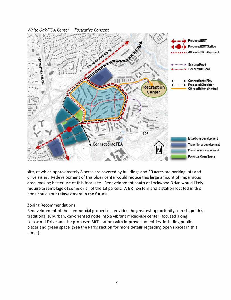
White Oak/FDA Center – Illustrative Concept
site, of which approximately 8 acres are covered by buildings and 20 acres are parking lots and drive aisles. Redevelopment of this older center could reduce this large amount of impervious area, making better use of this focal site. Redevelopment south of Lockwood Drive would likely require assemblage of some or all of the 13 parcels. A BRT system and a station located in this node could spur reinvestment in the future. Zoning Recommendations Redevelopment of the commercial properties provides the greatest opportunity to reshape this traditional suburban, car-oriented node into a vibrant mixed-use center (focused along Lockwood Drive and the proposed BRT station) with improved amenities, including public plazas and green space. (See the Parks section for more details regarding open spaces in this node.)

13

14
This Plan recommends rezoning the 41 acres of C-2 properties on the east side of New Hampshire Avenue to CR-2.5, C-1.5, R-1.5, H-200 (see number 1 on proposed zoning map). This Zone will allow more uses than current zoning, particularly housing. The proposed CR Zone requires a mix of commercial and residential uses in order to achieve the full 2.5 FAR. Improved connections to the surrounding residential community could include a circular loop trail from Lockwood Drive along Stewart Lane to Old Columbia Pike (see the off-road hiker-biker trail loop on the Illustrative Concept graphic). For commercial properties west of New Hampshire Avenue and south of Lockwood Drive, the Plan recommends rezoning the C-2 and C-O properties to CRT-1.5, C-1.0, R-0.75, H-50 (see number 2 on the proposed zoning map). The overall density and height of this proposed CRT designation is comparable to what is allowed under current zoning, but encourages a mix of commercial and residential should the site redevelop. The Dow Jones and Bank of America properties at US 29/Old Columbia Pike and Stewart Lane are recommended to be rezoned from I-3 and C-O to CR-1.0, C-1.0, R-0.75, H-65 (see number 3 on the proposed zoning map). Hillandale Community The Hillandale community, located north of I-495 along New Hampshire Avenue, includes established single-family neighborhoods, commercial uses, and the National Labor College. Our Savior Episcopal Church is a prominent local landmark at New Hampshire Avenue and Powder Mill Road. The Hillandale Shopping Center, built in the early 1960s, is anchored by a Safeway, a Value Village thrift store, and several restaurants. There are four office buildings along Elton Road, as well as a Coca Cola distribution facility. Ancillary retail uses and an office building are on New Hampshire Avenue north of Powder Mill Road. Much of the commercial area is in single ownership, including the shopping center and the three office buildings on the south side of Elton Drive adjacent to I-495. The office building at 10001 New Hampshire Avenue was completed in 2010 and is currently occupied by FDA employees. The other four office buildings in Hillandale were built between 1977-1986.

15

16
The National Labor College is located on a 46-acre site on the west side of New Hampshire Avenue at Powder Mill Road. The Labor College has operated at this site since 1971, succeeding Xaverian College, which operated there from 1931 to 1971 (see Historic Resources section). The property is currently for sale. Holly Hall, a 96-unit senior residence owned by the Housing Opportunities Commission, is located adjacent to the Labor College. Holly Hall is in the R-20 Zone and the Labor College is in the R-90 Zone (with a special exception for a private educational institution). Hillandale’s single-family residential neighborhoods are along both sides of New Hampshire Avenue with homes that border the Northwest Branch Park on the west and ones that border the FRC on the east. Cresthaven Elementary School and Francis Scott Key Middle School are located on the west side of New Hampshire Avenue and Hillandale Local Park and Hillandale Fire Station are on the east side. There are two private swim clubs in the neighborhood. Hillandale includes a number of potentially historic buildings as well as two clusters of single-family homes (the 1930-40s Hillandale homes and the 1960s Crest Park modernist homes) that may be evaluated in the future for historic significance (see the Historic Resources section).
The proposed Countywide BRT network includes a route on New Hampshire Avenue that initially could run between the proposed BRT station at the White Oak/FDA Center and the proposed Takoma-Langley Purple line station. Eventually, the New Hampshire Avenue BRT could extend from the ICC to the Fort Totten Metrorail Station (5.3 miles of this segment south of Elton Road/I-495 requires coordination with Prince George’s County and Washington, D.C.). Hillandale Community – Illustrative Concept

17
Zoning Recommendations To encourage redevelopment and reinvestment in this area, this Plan recommends that properties zoned C-1 and O-M (on the east side of New Hampshire Avenue) and the R-20 parcel (on the west side of New Hampshire Avenue) be rezoned to CRT-1.5, C-1.0, R-1.0, H-75 (see number 5 on the proposed zoning map). The goal for any redevelopment of the Hillandale Shopping Center site would be to concentrate density toward New Hampshire Avenue. The Plan will include language that, should redevelopment occur, adequate buffering must be provided between the commercially zoned properties and the adjoining single-family residential lots on Green Forest Drive. The Plan recommends that the I-1, C-O, and C-T properties (on Elton Road, east side of New Hampshire Avenue) be rezoned CRT-1.0, C-0.75, R-0.75, H-45 (see number 6 on the propose zoning map).
The Plan recommends that the eastern portion of the National Labor College site be rezoned from R-90 to CRT-1.5, C-1.0, R-1.0, H-75 (number 5 on map) and that the western, undeveloped portion remain in the R-90 Zone. The Plan recommends that the C-1 and C-T properties (on the west side of New Hampshire Avenue) and the C-1 properties (on the east side of New Hampshire Avenue, north of Powder Mill Road) be rezoned CRN-1.0, C-0.75, R-0.75, H-45 to address compatibility due to adjacent single-family lots on Overlook Drive (see number 7 on the proposed zoning map).
North White Oak/Cherry Hill Road Center This 800-acre area is bounded by US 29, Cherry Hill Road, the FRC property line, and the Paint Branch stream valley park. The 1997 Fairland Master Plan referred to this area as the US 29/Cherry Hill Road Employment Area and identified four sub areas — Montgomery Industrial Park, West Farm Technology Park, Site 2, and the Percontee sand and gravel facility – and considered the Paint Branch residential community separately. This Master Plan refers to this area as the North White Oak/Cherry Hill Road Center and includes the Paint Branch residential community. A 1997 Plan recommendation to acquire several parcels adjacent to the residential area for a park was implemented to create Stonehedge Local Park, located on Old Columbia Pike. The North White Oak/Cherry Hill Road Center has been home to light industrial and service uses, “back offices”, public sector facilities, and heavy industrial. Montgomery Industrial Park is the older section (developed between the late 1960s to the early 1980s) with buildings along Tech Road and Industrial Parkway. A six-acre site with a building formerly occupied by the American Postal Workers Union at Old Columbia Pike and Industrial Parkway is vacant. West Farm is the newer section (mostly developed in the late 1980s) with office buildings along Broadbirch Drive and Bournefield Way. This area includes a Home Depot and DarCars auto sales and repair center. Recent development includes the restaurant-oriented Westech Village Corner (at Tech Road and Broadbirch Drive), an adjacent Hilton Garden Inn hotel (on Broadbirch Drive), and a Marriott Residence Inn hotel (at Cherry Hill Road and Plum Orchard Drive). (See map below.)

18
North White Oak/Cherry Hill Road Center
In 2006, Adventist HealthCare (AHC) located its world headquarters on a 21-acre site at the southwest corner of US 29 and Randolph Road (outside the Master Plan area). With 600 employees, it is one of the area’s largest employers. AHC also owns 21 acres adjacent to the headquarters site, the Adventist Book Store located in the Orchard Center, and several area churches. In addition, AHC assembled five parcels totaling 48 acres along Plum Orchard Drive, where it has planned to relocate Washington Adventist Hospital from Takoma Park and build a new hospital and several medical office buildings. The Hospital received development approval from the Planning Board in 2008. A certificate of need is pending approval with the State of Maryland, with a decision expected this fall.

19
Existing Public Uses The North White Oak Center includes over 60 acres of publically owned land and facilities. The State of Maryland has a vehicle emissions station and a full service Maryland Vehicle Administration office as well as a National Guard Armory and State Highway Administration (SHA) maintenance facility. A United States Post Office distribution center is adjacent to the SHA facility on Plum Orchard Drive. WSSC has offices and a lab facility on Tech Road on a 10-acre site formerly owned by the Washington Post Company. Montgomery County Public Schools’ West Farm Bus Depot sits on a 15-acre site on Bournefield Way. M-NCPPC’s Stonehedge Local Park is located on Old Columbia Pike, and the Paint Branch stream valley park sits between the North White Oak and White Oak centers. Existing Industrial Uses The heavy industrial uses in this area (I-2 zoning) occurred at the former WSSC waste composting facility, referred to as Site 2, and continue today at the 185-acre Percontee sand and gravel operation. The gravel and sand deposits of the Coastal Plain portion of eastern Montgomery County have been commercially mined and extracted for their mineral resource value for years. Montgomery County’s decision to permit construction of the sludge composting facility at Site 2 in 1982 had significant land use implications for this area. As part of the Blue Plains Intermunicipal Agreement, Montgomery County was required to dispose of sewage sludge from the regional wastewater treatment plant at Blue Plains in Washington, D.C. A court order directed WSSC to construct a facility to process sewer sludge into compost, which was sold commercially under the brand name “ComPro.” After consideration of 14 sites, the County chose to locate the WSSC facility on Site 2 and operations began in 1983. Soon thereafter, residents and businesses complained of strong, noxious odors that were being emitted from the facility. Technological improvements failed to control the odors to consistently acceptable levels. The facility was eventually shut down due to community opposition and its negative economic consequences on the local area, which included reduced viability of the adjacent industrial/office park as tenants left and new businesses were difficult to attract. Percontee/Site 2 After closing the Site 2 facility, the County began to consider the 115-acre site for a public/private partnership to develop an East County Science and Technology Center to take advantage of the proximate location of the FDA headquarters. The County issued a Request for Proposals in 2008 for a development partner to create a “World Class Bio/Life Sciences, Education, and Research Community where the brightest and best regulators, researchers, professors, students and medical professionals can meet and share ideas, research and information that will lead to continuing technological, scientific and medical advancements.” In December 2011, the County chose Percontee as its Site 2 development partner. The Percontee property and Site 2 total 300 acres and the developer’s proposed development program includes over 7 million square feet of commercial space and 5,360 residential dwelling units in a “LifeSci Village.” If residential development were to occur at these proposed

20
amounts, staff at Montgomery County Public Schools has determined that an elementary school could be needed in the future. The Plan recommends that an adequate and appropriate site for an elementary school be provided on the Percontee property. 1997 Zoning The area’s zoning (I-1, I-2, and I-3) and the land use guidance from the 1981 Master Plan created the light industrial/office park development that exists today. These industrial zones allow limited uses and preclude retail and housing. The 1997 Fairland Master Plan recognized the limitations to these zones and recommended the US 29/Cherry Hill Road Employment Area Overlay Zone, which retained the underlying I-1, I-2, and I-3 Zones but added certain uses and eliminated others. The flexibility afforded by the overlay zone has helped create a more diversified and self-sufficient employment center while providing additional retail options for surrounding communities, most notably the Westech Village Corner development (built in 2006) that includes restaurants, a bank, and ancillary retail. The overlay zone was amended in 2005 to permit certain uses for properties in the I-2 Zone (Percontee and Site 2), including research, development, laboratories, health services, high technology, and related activities. In addition to the overlay zone, the 1997 Fairland Plan rezoned 42 acres of I-3 land on Cherry Hill Road to the C-6 Zone, a new zone the Plan recommended for low-intensity, regional commercial uses. Completed in 1998, this property was developed as the “big box” Orchard Center, bringing a significant amount of new retail to the area. Transit The Plan envisions the North White Oak/Cherry Hill Road Center as the focal point of a BRT network serving the Plan area. Two of the three corridors under study (US 29 and Randolph Road) could potentially serve this area with stations located near or at Percontee/Site 2 and the proposed Washington Adventist Hospital. Two additional BRT corridors, largely in Prince George’s County – one serving Konterra/Muirkirk MARC via Powder Mill Road and the other serving the Greenbelt Metrorail Station, are also envisioned as part of an eventual Countywide network. A key supporting or complementary feature of these BRT corridors could be one or more internal circulator bus routes connecting key points within this center and also connecting this center with the other areas – White Oak/FDA, Hillandale, and Burnt Mills. (See “proposed circulator” on Illustrative Concept graphic.) Zoning Recommendations As with the other commercial centers, the Plan recommends CR Zones for most properties in the North White Oak/Cherry Hill Road Center to encourage redevelopment and provide zones with land use flexibility. The Plan recommends that Site 2 be rezoned from I-2 to CR-1.25, C-1.0, R-0.25, H-200 (see number 10 on the proposed zoning map) with the intent of concentrating density for the proposed development in this area, hopefully with a proposed BRT station. The Plan recommends rezoning the Percontee property from I-2 to CR-0.75, C-0.5, R-0.5, H-75 (see number 9 on the proposed zoning map). The remainder of this node is

21
North White Oak/Cherry Hill Road Center - Illustrative Concept
recommended to be rezoned from I-1, I-3, C-6, and C-1 to CR-0.75, C-0.75, R-0.25, H-75 (see number 8 on the proposed zoning map). The five parcels that are owned by AHC (and proposed for Washington Adventist Hospital), currently zoned I-1 and I-3, are recommended for the Life Sciences Center Zone, which is intended “to promote research, academic and clinical facilities that advance the life sciences, health care services and applied technologies” (Section 59-C-5.47). The LSC Zone (and CR Zone) allows hospitals by right. The LSC Zone has been successfully used by Shady Grove Adventist Hospital, located in the Great Seneca Science Corridor Master Plan area. This zoning recommendation will be revisited if the hospital does not receive a Certificate of Need (CON) from the State. At this point, the proposed hospital has regulatory land use approvals (including a Special Exception under current zoning), but not a CON. Burnt Mills Community The Burnt Mills community is largely residential and includes the Burnt Mills Hills subdivision of large lots and estate type homes in a natural setting. The Burnt Mills Hills Historic District has been determined National Register eligible by the Maryland Historical Trust and may be evaluated in the future for inclusion on the County’s Master Plan for Historic Preservation.

22
After years of sitting vacant, a former furniture store was redeveloped in 2005 as the Shoppes of Burnt Mills, anchored by Trader Joe’s. The small commercial area on the southeast corner of US 29 and Lockwood Drive also includes the Colewood Centre medical office building, a self-storage facility, an automotive shop, and several ancillary retail uses. In 2005, new townhomes were built off Lockwood Drive near Oak Leaf Drive. The BRT Functional Master Plan is studying a conceptual alignment for the US 29 BRT to run on Lockwood Drive (rather than along US 29 between Lockwood Drive and Stewart Lane). The proposed Lockwood Drive alignment provides the opportunity for BRT stops to be considered at the Burnt Mills shopping center and at Oak Leaf Drive. (See the BRT graphic.) Zoning Recommendations This Plan does not anticipate additional redevelopment or new development in the Burnt Mills area given the relatively new retail and lack of available land. The Plan recommends rezoning the commercial properties from C-4, C-T, and C-O to CRT-0.75, C-0.5, R-0.25, H-45 (see number 4 on the proposed zoning map).
AREAWIDE PRELIMINARY RECOMMENDATIONS This section provides an overview of areawide preliminary recommendations on the following:
Mobility and Connectivity
Parks, Open Spaces, and Recreation
Natural Environment
Historic Resources
Implementation and Staging MOBILITY AND CONNECTIVITY The Master Plan area is near a number of major, regional transportation facilities, which serve both local and regional traffic. Two major highways – US 29 and New Hampshire Avenue – intersect (at an interchange) in the Plan area and connect the communities of White Oak to each other and to the surrounding region. US 29, the major north-south transportation facility in the eastern County, is the most critical roadway for this Plan due to its potential impacts—both positive and negative—on the Plan and the area’s future. Interstate 95, the major north-south interstate highway serving the eastern United States, parallels US 29 two and a half miles to the east in Prince George’s County. I-495 forms the southern boundary of the Plan area, with an interchange at New Hampshire Avenue. The 18-mile Intercounty Connector (ICC/MD 200) connects the Plan area with I-95 and I-270 via full interchanges at US 29 (between Fairland and Briggs Chaney Roads) and New Hampshire Avenue and a partial interchange at Briggs Chaney Road (entrance only for westbound traffic).

23
Like many suburban locales, the White Oak area has relatively limited options for new vehicular connections. Residential streets wind through the neighborhoods with few through streets to interconnect communities, which forces local traffic onto the major highways. Physical constraints limit opportunities to improve local and through circulation. The large Federal Research Center property does not allow through public streets and there are no options for additional crossings of the Paint Branch, Northwest Branch, and I-495. Traffic Modeling Analysis Staff conducted a traffic modeling analysis of three different scenarios to determine the adequacy of the current roadway network and to identify potential improvements to support the level of development to achieve the vision of the Plan.
1. Existing Conditions: What is built plus what is in the pipeline (approved but not built yet)
2. 2040 Round 8.0 COG Forecast Scenario included the forecast of the most likely
development projections based on the current zoning and the 1997 Master Plans, with no significant change in market conditions or the regulatory environment. It included Konterra as well as other existing and proposed development within Prince George’s County, the proposed relocation of Washington Adventist Hospital, FDA expansion and completion, and other approved and/or reasonably expected development in and around the Plan area. It did not include the proposed BRT network or the land use associated with the Plan vision for the three primary activity centers at White Oak, Hillandale, and North White Oak/Cherry Hill.
This scenario included grade-separated interchanges along US 29 at Stewart Lane, Industrial Parkway/Tech Road (within the Plan area) and at Musgrove Road, Fairland Road, Greencastle Road and Blackburn Road (outside the Plan area). These interchanges, with the exception of US 29 at Industrial Parkway/Tech Road, are currently in the State’s FY 12-16 Consolidated Transportation Program. This scenario also included an extension of the existing FDA Boulevard in the North White Oak/Cherry Hill Road Center, connecting through Site 2 to Industrial Parkway.
3. The Master Plan Scenario assumed a significantly higher level of development, as
envisioned by stakeholders in the planning process, and to support the proposed BRT network. It included all of the grade-separated interchanges and road improvements assumed in the 2040 scenario. In addition, it assumed rebuilding the Old Columbia Pike bridge over the Paint Branch stream valley park, which has been closed to vehicular traffic for over 30 years.
The Master Plan scenario also assumed the following BRT network:
US 29 – Silver Spring Transit Center to Burtonsville Park-and-Ride
New Hampshire Avenue - White Oak Transit Center (on Lockwood Drive) to Takoma Langley Transit Center

24
Greenbelt Metrorail Station via I-495 Express Bus – Hillandale Station at/near Powder Mill Road to Greenbelt Metrorail Station
Muirkirk MARC/Konterra via Powder Mill/Ammendale Roads – Site 2 Station vicinity (near US 29 and Tech Road) to Muirkirk MARC
Randolph Road/Cherry Hill Road – Twinbrook Metrorail Station to Site 2 Station vicinity The three scenarios are summarized in the following table:
Existing Development (including pipeline)
2040 (Round 8.0 COG Forecast)
Master Plan Scenario
Commercial (sf) 12,000,000 15,854,000 25,434,850
Single-Family DUs Multi-Family DUs Total DUs
2,260 4,858 7,118
2,404 5,194 7,598
2,785 12,903 15,688
Jobs 31,168 40,063 70,312
For the 2040 Scenario, the traffic modeling showed that the following at-grade intersections would likely exceed the existing 1475 CLV standard established by the Subdivision Staging Policy for the Fairland/White Oak policy area (Derwood and Aspen Hill are the other policy areas with a 1475 CLV):
Inside the Master Plan area Outside the Master Plan area, within the study area
Less than 10% over CLV standard
New Hampshire Avenue & Lockwood Drive (PM only) Cherry Hill Road and Plum Orchard Drive (PM only)
Between 10% and 20% over CLV standard
New Hampshire Avenue and Powder Mill Road (PM only)
US 29 and University Boulevard – North bound US 29 and University Boulevard – South bound (AM Only)
More than 20% above CLV standard
US 29 and University Boulevard – South bound (PM Only)
For intersections located within Prince George’s County (the Prince George’s County’s CLV standard for these intersections is 1450), the 2040 Scenario indicated the following forecasted CLVs (AM/PM): • Fairland Road and Briggs Chaney Road - 1725/1275 • Powder Mill Road and Cherry Hill Road - 2236/2035 • Powder Mill Road and Beltsville Road – 1732/1661 • Powder Mill Road and Riggs Road – 1925/2025

25
For the Master Plan Scenario, the traffic modeling showed that the following at-grade intersections would likely exceed both the current 1475 CLV standard for the policy area as well as a 1600 CLV standard:
Inside the Master Plan area Outside the Master Plan area, within the study area
Between 10% and 20% over CLV standard
New Hampshire Avenue and Mahan Road/Schindler Drive Cherry Hill Road and FDA Boulevard
More than 20% above CLV standard
New Hampshire Avenue & Powder Mill Road Cherry Hill Road and Broadbirch Drive/ Calverton Boulevard Cherry Hill Road and Plum Orchard Drive/ Clover Patch Drive
US 29 and University Boulevard – northbound US 29 and University Boulevard – southbound
For intersections located within Prince George’s County, the Master Plan Scenario indicated the following forecasted CLVs (AM/PM):
Fairland Road and Briggs Chaney Road - 1775/1275
Powder Mill Road and Cherry Hill Road - 2239/2115
Powder Mill Road and Beltsville Road – 1782/1761
Powder Mill Road and Riggs Road – 1475/1875 A comparison between the 2040 COG and the Master Plan scenarios reveals that the impact of the higher land use assumed in the Master Plan scenario is largely limited to intersections within the Plan area. Due largely to through traffic resulting from planned regional development, the intersections examined that are outside of the Plan area (including those in Prince George’s County) are likely to experience traffic volumes exceeding the CLV standard independent of the scale and location of development envisioned in the Plan. An example of this phenomenon is the projected traffic conditions at the intersection of US 29 and University Boulevard (Four Corners), approximately 1.5 miles south of the White Oak. Assuming the 2040 COG scenario, the projected CLVs at this location are between 1800 and 1841 during the morning peak hour and 1778 to 1976 during the evening peak hour. Assuming the Master Plan scenario, which reflects significantly higher development densities in the Plan area relative to the 2040 COG levels, the projected CLVs at this location are between 1815 and 1865 during the morning peak hour and 1793 to 2000 during the evening peak hour. The Policy Area Mobility Review (PAMR) analysis for 2040 indicates that while the area remains “out of balance” for both the 2040 scenario and the Master Plan scenario, the concept BRT network for the area does improve the overall network performance within the policy area. Summary of Road Network Recommendations The Plan recommends the following roadway improvements to help support the proposed level of development modeled in the Master Plan Scenario.

26
Roadway improvements within the Master Plan boundaries:
Old Columbia Pike bridge over the Paint Branch rebuilt and open to vehicular traffic
Grade-separated interchange at US 29 and Stewart Lane
Grade-separated interchange at US 29 and Industrial Parkway/Tech Road
Roadway improvements outside the Master Plan boundaries:
Grade-separated interchange at US 29 and Musgrove Road
Grade-separated interchange at US 29 and Fairland Road
Grade-separated interchange at US 29 and Greencastle Road
Grade-separated interchange at US 29 and Blackburn Road Internal Road Network within Activity Center:
A Business District Street within the North White Oak/Cherry Hill Road Center connecting Industrial Parkway (from its current terminus at the Site 2 property line) to FDA Boulevard (see “Proposed Street” on the Existing and Proposed Street Network map below).
Transit This Plan relies on an efficient and attractive transit network to achieve the vision of transforming this area into a vibrant, jobs and mixed-use center as described in this report. The type and level of growth needed to achieve this vision cannot be supported by road improvements alone; there must be a robust transit network that connects the area to the rest of the eastern County and the region’s transit and highways. In order to answer some big picture questions, staff worked with a consultant through a grant from COG and the Transportation Planning Board’s Transportation Land Use Connection (TLC) technical assistance program early in the process. This work included a broad, sketch level analysis that examined the potential development required to support various forms of fixed guideway transit service in the Plan area. The study found that:
a. Metrorail was cost prohibitive and would require a significant amount of additional development (exceeding 100 million gross square feet) that would likely overwhelm the remaining infrastructure.
b. BRT and LRT offered the most compatible match between transit and land use with BRT being preferable from a cost and timing standpoint.
c. Current land use (reflecting current zoning) suggests the New Hampshire Avenue corridor would initially have higher ridership than US 29.
d. Extensions to serve Konterra and the Muirkirk MARC station would be as cost effective as the other corridors and should be considered.

27
Based on the results of this study, staff focused on the BRT option as a potentially feasible transit solution to address the traffic congestion in this area. While staff was conducting this sketch level analysis for the Master Plan, the Montgomery County Department of Transportation (MCDOT) completed a feasibility study (in July 2011) of a network of BRT corridors that included US 29 and New Hampshire Avenue. This study also included a route on Randolph Road from the White Flint Metrorail Station to the Glenmont Metrorail Station. (The study initially examined a route on Randolph Road/Cherry Hill Road that

28
extended east of the Glenmont Metrorail Station to the Prince George’s County line, but the segment east of Glenmont was not carried forward to the final set of routes because the future estimates of population and employment densities were lower in the eastern County than other areas). The DOT study found that a BRT network of corridors was feasible, with estimated weekday ridership between 165,000 and 207,000 by 2040. The overall average BRT travel speed was 17.4 mph. The study assumed no additional right-of-way beyond the existing right-of-way, and assumed that buses would generally travel in mixed traffic along segments where there was no room for exclusive lanes, but exclusive lanes could be provided over some segments in the peak direction. In anticipation of MCDOT’s study, the County Executive appointed a Rapid Transit Task Force in February 2011 to follow up on the work and eventual recommendations of the Countywide BRT Study. The Task Force developed a preliminary Concept Plan that included additional detail on the possible attributes or features of selected BRT corridors. This Plan was largely (but not entirely) limited to what could be accomplished within the existing right-of-way. There was a general acknowledgment that additional right-of-way would be needed to accommodate some station locations and at some of the major intersections where dedicated left turn lanes or a queue jump should be provided. The Task Force’s Concept Plan included recommendations related to three corridors within the Plan area – US 29, New Hampshire Avenue, and the Randolph Road/Cherry Hill Road corridor, which extends east of Glenmont to FDA Boulevard. The Planning Department is currently conducting an update of the Countywide Master Plan of Highways (the Countywide Transit Corridors Functional Master Plan), which will focus on identifying the minimum master plan right-of-way necessary to implement a Countywide BRT in selected corridors. The draft recommendations for the Countywide Transit Corridors Functional Master Plan are currently scheduled to be presented to the Planning Board this fall and transmittal of the Planning Board Draft Plan to the County Council is scheduled for April 2013. The Planning Board Draft of the WOSG Master Plan is scheduled to be transmitted to the County Council in July 2013.

29

30
Staff believes that the Countywide Transit Corridors Functional Master Plan will address the right-of-way requirements of all BRT corridors in the County, including the WOSG Plan. The same type of scheduling issues exist with the Glenmont Sector Plan, where there are two potential BRT corridors (Georgia Avenue and the same Randolph Road/Cherry Hill Road corridor that is in this Plan). There are three primary technical papers related to the Countywide Transit Functional Master Plan that can inform the preliminary recommendations on BRT for the WOSG Plan: • Network and Methodology Report (December 2011) • BRT Corridor Function Assessment (DRAFT) (March 29, 2012) • BRT Typical Sections – Update (Final Draft) (April 18, 2012) These technical reports, along with the prior studies noted above, form the basis for arriving at the preliminary BRT recommendations for this Master Plan. More specifically, the prior work helps identify the individual corridor characteristics and constraints, and also helps in arriving at a “default” minimum right-of-way section of 120 feet that is required to provide the exclusive or dedicated transit lane for roadways with three existing travel lanes in each direction. Summary of BRT Network Recommendations The preliminary recommendations for the proposed BRT network to serve the WOSG Plan area consist of the following corridors within Montgomery County:
US 29
New Hampshire Avenue
Randolph Road Two other possible BRT corridors within Prince George’s County are:
North White Oak/Cherry Hill Road Center to Konterra/Muirkirk MARC Station via Powder Mill Road/Ammendale Road
Hillandale Center to Greenbelt Metro via I-495 Fairland/White Oak Policy Area Review (PAMR and TPAR) The traffic modeling analysis also included a review of the relative arterial mobility for the Fairland/White Oak Policy Area using the Policy Area Mobility Review (PAMR) methodology. This analysis assumed the Round 8.0 Cooperative Forecast Land Use and the regional roadway network as contained in the Constrained Long Range Plan - with the addition of the previously noted planned interchanges and the BRT network. Under PAMR, the relative arterial mobility of a policy area is the ratio of the average congested arterial auto travel speed to the free flow arterial auto travel speed. County policy is that a master plan can be determined to be in balance if the average congested arterial auto speed is forecasted to be no less 40% of the free flow speed (essentially equivalent to Level of Service D). The analysis indicated the average arterial congested auto travel speed would be around 34% of the free flow speed, and therefore less than the County criteria established by policy. The Planning Board recently considered changes to PAMR and has forwarded recommendations to the County Council on the introduction of a different methodology, the

31
Transportation Policy Area Review (TPAR). The TPAR approach also considers the Fairland/ White Oak Policy Area to be below the adopted standard – essentially below an average Level of Service D for the arterials within the Policy Area when considering a horizon year of 2040 with the Round 8.0 Cooperative Forecast land use. US 29 functions, in part, as a limited access facility between the County line and New Hampshire Avenue. Traffic forecasts indicate that while the current intersection performance is acceptable within the Plan area, it will worsen in the future without the construction of the unbuilt, planned interchanges under any land use scenario. The corridor is also only one of three (I-495 and I-270 being the others) in the County that has seen an overall increase in Average Annual Daily Traffic (AADT) during the past seven years. This suggests that the corridor functions in a manner similar to I-495 and I-270 in that it has a higher percentage of through trips with longer than average trip length for the segment within the Fairland/White Oak area. The Planning Board’s recommendations on TPAR also noted that the WOSG Plan process should address whether the US 29 corridor should be considered a limited access highway when evaluating the network performance within the Policy Area. This approach is based on the fact that, with the implementation of all the planned grade-separated interchanges on US 29 between MD 650 and MD 198, this roadway would function as a limited access highway through much of the policy area, rather than as a conventional major highway. When analyzing whether a policy area is in balance, County policy does not explicitly include consideration of peak hour speeds on limited access highways such as I-495 and I-270. There is support for treating US 29 in this manner – essentially excluding US 29 from any analyses of the average congested auto travel speed for arterials in Fairland/White Oak. Whether adopting this approach would result in the Policy Area being “in balance” needs further analysis. It should be noted that if US 29 is considered a limited access highway in the context of Policy Area Review, Local Area Transportation Review would still be applicable and would have to be addressed by development proposals. Bikeway and Pedestrian Network It is important that the increased emphasis on transit and connectivity be complemented by bikeway and pedestrian networks that also support the overall goal of reducing trips by single occupant auto drivers. Well-designed, safe, and interconnected bike and pedestrian facilities reinforce the commitment to travel options and visually communicate that the area is transitioning to a place where you can get from one activity to another without necessarily depending upon auto travel for every trip.
The preliminary recommendations include the following new bike facilities:
Shared Use Path on FDA Boulevard (off road)
Bike Lanes on Prosperity Drive (on road)
Bike Lanes on Powder Mill Road (on road)
Bike Lanes on Plum Orchard Drive (on road)
Bike Lanes on Industrial Parkway (on road)

32
Signed Shared Roadway on Broadbirch Drive (on road) On-Going Additional Analysis Staff is continuing to analyze and coordinate on several issues related to the preliminary recommendations and the findings of the transportation analysis to date. These issues are discussed below. Potential Intersection Improvements Additional analysis needs to be conducted on the potential for physical improvements that would address the intersection capacity issues at the following intersections within the Plan area:
New Hampshire Avenue and Powder Mill Road
Cherry Hill Road and Broadbirch Drive/Calverton Boulevard
Cherry Hill Road and Plum Orchard Drive/Clover Patch Drive Mode Split The transportation analysis and resulting recommendations are based upon an assumption that 14 percent of the commuters will arrive to jobs within the Plan area by some mode other than auto – 25 percent if they are headed to jobs in one of the activity centers. By comparison, the commuter mode share assumptions used in support of the 2010 Great Seneca Science Corridor (GSSC) Master Plan and the 2010 White Flint Sector Plan were 30 percent and 50 percent, respectively. The 30 percent commuter mode share assumption for the GSSC Master Plan was determined to be appropriate given the planned Corridor Cities Transitway through that area. The 50 percent commuter mode share assumption for White Flint was determined to be appropriate given the availability of the Red Line Metrorail service in that area. Raising this percentage to 30 percent in the context of the WOSG Plan would not be expected to make a significant difference in the CLV results. Raising this percentage above 30 percent for the purpose of this analysis is problematic given that a transition from auto to a more transit-oriented, mixed-use setting, while highly desirable, is still aspirational at this point in time. The introduction of a Transportation Management District that would include the three major activity centers (which include the FDA) is recommended.
33
PARKS, OPEN SPACES, AND RECREATION
Parks, Recreation, and Open Space (PROS) Plan The 2012 PROS Plan, approved by the Planning Board in July 2012, established new guidelines for urban parks. Recognizing that the pattern of open space systems in areas of increasing density should support vibrant mixed-use centers, PROS recommends open spaces that will be comfortable, attractive, easily accessible, and provide a range of experiences, up to, and including festival and outdoor event spaces. The system of parks and open spaces for each master plan or sector plan area should be provided through a combination of public and private efforts. Those open spaces that rise to the level of serving as a focal point of community life for the Plan area are typically recommended to be publicly owned and operated parks, while those open spaces serving districts, nodes, or neighborhoods are often recommended as public use spaces to be provided by the private sector. Attributes of the County’s parks and open system include active recreation, social interaction, access to green space, relaxation and stress relief, public accessibility, educational value, walkability, connectivity, flexibility, and activating uses. PROS established six new categories of urban parks in a revised Park Classification System, including: Civic Green Urban Park, Countywide Urban Recreational Park, Urban Greenway, Neighborhood Green, Urban Buffer Park, and Community Use Recreational Park. Several of these park types are recommended for the centers in this Plan. In order to achieve a system of parks, trails, and open spaces, PROS recommends the following hierarchy for all new master plans and sector plans:
For the Master Plan Area:
o recreation destinations located within or near the plan area, including courts, playgrounds, and lawn areas large enough for pick up soccer, relaxing on the lawn, festivals or events, etc.
o a central Civic Green Urban Park, ranging in size from 1/2 to 2 acres, depending on projected densities, located in close proximity to a public transit hub, next to activating uses, with a combination of hard and soft surfaces including a central lawn area for events
o an interconnected system of sidewalks and trails to connect parks and open spaces to one another and to the surrounding community
o wooded areas that will provide a sense of contact with nature
For each Urban Neighborhood: a Neighborhood Green, Urban Buffer Park, or Community Use Urban Recreational Park
For each Block: an urban square, plaza or green area
For each Building: outdoor recreation space
For each Residence: private outdoor space

34
For the East County, which includes this Master Plan area, the 2005 Land Preservation, Parks and Recreation Plan/Park, Recreation and Open Space Plan (LPPRP/PROS) estimated an unmet need for five adult rectangular fields and one youth rectangular field. The 2012 PROS Plan did not update the estimates, but directed Parks staff to complete a future Athletic Field Study. Since 2005, two adult fields have been constructed, one at Cross Creek Local Park and one at April Lane Local Park, as well as one youth field at Stonehedge Local Park, leaving an estimated unmet need of three adult sized rectangular fields. The Vision 2030 Strategic Plan, approved by the Planning Board in 2011, indicated the most important facilities to improve and expand are: recreation centers, aquatic facilities, health and fitness facilities, trails, natural areas, playgrounds, athletic fields, dog parks, and community gardens. Vision 2030 also recommends strategic location of skate parks and volleyball courts. Of these facilities, the WOSG Master Plan area is currently well-served for indoor recreation, health and fitness facilities, community meeting rooms, and skate parks. If future new development or redevelopment occurs within the Master Plan area, additional parks and open spaces should be provided, as outlined below. Summary of Parks Recommendations The recommendations for parks, open spaces, and trails aim to provide space for unmet needs per the guidance from PROS and Vision 2030 Strategic Plan while organizing spaces into an interconnected system of parks and open spaces within and between each of the Plan’s potential redevelopment areas. Since there is uncertainty about what new development and redevelopment may ultimately occur in this area, the numbers and sizes of recommended facilities may need to be adjusted after the approval of the Staff Draft by the Planning Board. Area-wide recommendations are listed, followed by recommendations for each center. Expansion of Maintenance Facilities When redevelopment and new development occurs within this area, several new parks and facilities may be built that will require a higher level of maintenance and policing than a typical local park. To accommodate planned growth of parks, this Plan recommends expanded maintenance facilities within or near the Master Plan area. Staff is analyzing possible sites, including potential co-location with other publicly owned parcels within or near the Master Plan area. Dog Parks The Department of Parks currently has five off-leash dog parks, all of which are located in regional or recreational parks across the County; yet, there is an increasing demand for them in the higher density areas of the County. Off-leash dog parks will likely be in demand in the Plan area since it includes many multi-family residences with no open space for dogs to run freely today and in the future. Dog parks require a higher level of management than many other park facilities. If they become overcrowded, conflicts between dogs and owners may require attention from Park Police. If they are small, regular replacing of the surfacing is needed. Privately owned and operated dog “spots” in public use areas or within the private outdoor space of high density residential buildings are encouraged. In the Plan area’s proposed new

35
parks, as well as in existing parks to be renovated, new models of dog parks with increased levels of maintenance and security will be explored. Parkland Acquisition Opportunities
This Master Plan recommends that opportunities for acquisition of additional parkland to meet identified goals (such as stewardship, trail connectivity, or recreational needs) should be pursued by the Parks Department. Specific opportunities and recommendations for new parkland are discussed below for each center within the Master Plan. In addition, private swim club properties or other larger assemblages of properties that become available should be considered for acquisition.
Parks Recommendations for Centers White Oak/FDA Center As discussed above, there is potential for mixed-use redevelopment of the White Oak Shopping Center (at the southeast quadrant of New Hampshire Avenue and Colesville Road) and potentially the commercial uses along the south side of Lockwood Drive.
Issue: Poor connectivity for walkers and bicyclists given the barriers of major roads and the lack of public access onto the Federal Research Center (FRC) property.
Opportunity/Recommendations: o New streets and/or pedestrian paths to provide connections to the FDA
campus so that employees can better access community retail and services, and so that the existing apartments to the northeast would have better access/connections to this commercial center.
o A recreation loop, consisting of sidewalks and bikeways that connects the core of activity to the existing residential area to the east.
o Connections for pedestrians and bicyclists to local destinations such as the White Oak Recreation Center, the North White Oak/Cherry Hill Area via Old Columbia Pike bridge, the bikeway on New Hampshire Avenue, and to regional trails and bikeways.
o Designate 130 acres of forest along the main stem of the Paint Branch through the FRC as a Legacy Open Space (LOS) Natural Resource site. If these high quality, sensitive environmental resource areas on the FRC site should become available through the surplus process, the Legacy Open Space designation would provide a means to pursue acquisition as parkland and provide key stewardship for parkland and trail linkages in the Master Plan area. The core area of FRC forest is a very high quality natural resource, representing a key gap in public access to the Paint Branch Stream Valley and includes mature century-old (or older) forest supporting forest interior dwelling species. The recommended LOS Natural Resource area excludes known structures and improvements.

36
Issue: Need for parks and open spaces in the White Oak Center, particularly areas of open lawn for a variety of activities, trees for shade and a sense of contact with nature, and areas for gathering.
Opportunity/Recommendations: o An urban plaza, approximately ¾ acre in size, owned and managed by the
private sector, in the core of a redeveloped White Oak shopping center to serve as a public gathering place near a transit stop and a focus of commercial activity.
o A Neighborhood Green Urban Park, approximately two acres in size, to serve as a green community open space for a variety of activities including picnicking, pick-up sports, and relaxing on the lawn. If future site selection studies by the Department of Parks indicate a need, the park could include other local amenities such as community gardens and a dog park. It would be owned and managed by the Department of Parks, and located at the eastern edge of the Center nearest the existing multi-family residences.
o Improve connectivity for walking and cycling to the nearby White Oak Recreation Center to the east via bike paths, and Martin Luther King Recreational Park to the north, and Hillandale Local Park to the south via a shared use bike path on New Hampshire Avenue.
Hillandale Community The Hillandale Shopping Center and Hillandale Local Park are on the east side of New Hampshire Avenue and the National Labor College is on the west side of New Hampshire Avenue. East Side:
Issue: If the shopping center redevelops, an urban plaza for gathering in the retail areas will be needed by the expanded population.
Opportunities/Recommendations: o Provide an urban plaza, approximately ½ acre in size, owned and managed by
the private sector, to create an attractive and relaxing environment for people who live, work, and visit the redeveloped center.
Issue: The existing Hillandale Local Park is in need of renovation and reconfiguration. The play area is hidden from view, the parking and vehicular circulation is disjointed, and the Park Activity Building is underutilized.
Opportunities/Recommendations: o Remove the Park Activity Building (upon approval by the Planning Board as part of a
Parks Department agenda item), to allow for repurposing of parkland with facilities that are in demand, such as community open space, reconfigured play areas, etc. (Final program and park design to be determined through the currently funded Facility Plan.)

37
North White Oak/Cherry Hill Road Center This Center, bounded by Colesville Road, Cherry Hill Road, and the Paint Branch Stream Valley Park, includes the 185-acre Percontee parcel and the 115-acre Site 2 parcel that are planned for new mixed-use development, including retail, residential, and offices. Other new development planned in the area includes a 49-acre property on Plum Orchard Drive that is owned by Adventist Healthcare, Inc. and has regulatory approval for a new Washington Adventist Hospital.
Issue: Parks, open spaces, and trails are needed for the future population of residents, workers, and visitors, including places for formal and informal gatherings, active recreation, spontaneous play, contact with nature, as well as connections within this center and beyond to other destinations. The existing 4.4-acre Stonehedge Local Park, which contains two playgrounds, basketball court, and a small multi-use field, is inadequate to meet the needs of a new high-density, mixed-use center.
Issue: The 300-acre Percontee/Site 2 property should provide extensive open space opportunities and new development should be sensitive to the adjacent Paint Branch Stream Valley Park.
Opportunity/Recommendations: o A Civic Green Urban Park, approximately 1 acre in size, to serve as a gathering
space for community events, meeting friends, and as a focal point in the highest density cluster of retail and residential uses that may equate to a “town center.” The Civic Green should be a formally planned, flexible, programmable open space.
o An active Local Park with a large adult-sized rectangular athletic field and other popular amenities such as a community garden, dog park, basketball courts, and community open space, urban wooded areas, and play areas. Provide on-street parking to the extent possible and assume a reduction from the typical local park parking standards since many park users could walk or take transit. For the athletic fields, consider synthetic turf and lighting to provide longer hours of use and higher overall capacity. To maximize efficiencies of parking and community use, co-locate with a proposed elementary school, which will be needed if planned residential densities are achieved.
o Privately owned and managed public use spaces similar to Neighborhood Green Urban Parks for each district in the 300-acre development with open lawn areas, shaded seating, play structures, community gardens, and dog spots or similar neighborhood recreation facilities.
o A trailhead on parkland with picnic tables, interpretive signage, and a natural surface trail to the stream along the old roadbed, at the eastern edge of the Paint Branch Stream Valley Park. Dedication of additional land may be needed to accomplish this.
o An integrated trail and bikeway system that connects perimeter trails to destinations throughout the development. All trails and park facilities, except for a carefully sited natural surface trail to the river along the old roadbed,

38
should remain outside of sensitive areas. Accordingly, a perimeter trail, whether a bikeway along a road right-of-way, or a hard surface trail on expanded parkland, should be located adjacent to the top of the stream valley, thereby offering visual access into the stream valley park throughout its length, and physical access only by the natural surface trail. To reinforce public access to the edge of the stream valley, there should be no private lots backing up to the stream valley park.
o A trail connecting to the proposed walking path around the regional storm water pond on the proposed Washington Adventist Hospital site.
o Designate 20 acres of steeply sloped, mature forest at the edge of development along the Paint Branch Stream Valley Park as a Legacy Open Space Natural Resource site. At time of regulatory review, determine whether this forest resource should be preserved through easement and/or dedication to Parks.
o Ensure that adequate publicly accessible space (50-100 feet) beyond the regulatory stream buffers is provided in easement or dedication to Parks for trails and bikeways in some areas.
o A sustainably designed and aligned multi-use natural surface trail connecting the Plan area to Martin Luther King Recreational Park. The 1997 White Oak Master Plan and the 1997 Fairland Master Plan recommended extension of the hard surface Paint Branch trail from Martin Luther King Recreational Park south to Old Columbia Pike (if a sustainable design could be developed) to improve the regional hiking and bikeway network by providing passage underneath US 29, which otherwise forms a barrier to recreational bicycle and pedestrian travel. Sustainable trail design involves low impact to environmentally sensitive areas and low operating and long-term maintenance costs. A trail connection is highly desirable between the existing and future residents in the White Oak area south of Colesville Road and the MLK Recreational Park north of Colesville Road; alternative bicycle and pedestrian routes along existing streets are unavailable or overly circuitous. A park trail in the stream valley is the most efficient way to connect the recreational park with the White Oak area. The 1997 Plan recommendations for a hard surface trail were made prior to the availability of detailed mapping of sensitive resources in the park system. As part of both this Plan update and the Countywide Park Trails Plan (CWPTP), issues were explored including environmental constraints, steep slopes, projected demand for trail use, current and future population densities, availability of alternative routes along public streets, likely construction costs, and long term operational/maintenance costs. Based on this analysis, a hard surface trail is not recommended because it adversely impacts sensitive resources, entails significant topographic challenges (connecting to Old Columbia Pike), and requires long stretches of boardwalk in a floodplain which is expensive to install and maintain.

39
Burnt Mills o Activate the Robert Morse Filtration Plant Buildings (built in 1936 and formerly
known as the WSSC buildings) through a “directed partnership,” investing in the adaptive reuse of the structures and in improvements to environmental conditions at Northwest Branch. Coordinate with the Historic Preservation Commission since the buildings are designated on the Master Plan for Historic Preservation and with the Maryland Department of the Environment due to the dam and potential stream restoration.
NATURAL ENVIRONMENT Overall Goal The overall environmental goal for the WOSG Master Plan area is to allow development at higher densities without compromising the environmental quality of this unique area. Development should respond to, and incorporate, the natural environment, including topography. Resource Protection and Preservation
Avoid impacts to natural resources as much as possible when altering or adding to the transportation network.
Where possible, use required forest and tree planting to enhance and expand existing resources, especially in stream valley buffers.
Minimize grading and preserve areas of steep slopes and highly erodible soils. Water Quality
Preserve and restore stream valley buffers in forest.
Minimize imperviousness through compact development.
Implement restoration projects as detailed in the Anacostia River Watershed Restoration Plan through the redevelopment process.
Minimize erosion by restricting development on steep slopes.
Incorporate stormwater management into the interior of development projects to maximize infiltration as a treatment “train” effect.
Minimize stormwater management outfalls on steep slopes, particularly in stream valley buffers.
Maintain tree canopy coverage in the Master Plan area and increase tree canopy of redeveloped properties and new development to a minimum of 30 percent.
o Increase canopy coverage over parking areas. o Restore unforested stream valley buffers. o Incorporate trees into stormwater management facilities whenever practicable.
Build new streets and retrofit existing roads as green streets, with stormwater management facilities in the right-of-way.

40
Air Quality/Climate Protection
Create opportunities for new and re-development that take advantage of existing infrastructure and adaptive re-use of existing structures where appropriate.
Develop compact, mixed-use neighborhoods that are walkable.
Minimize urban heat island effect by: o Maximizing tree cover over parking lots. o Using vegetated roofs or cool roofs. o Minimizing new surface parking and promote the sharing of existing parking lots.
Maximize use of renewable energy systems to supply a portion or all of a building’s energy demand. Alternative energy systems may include:
o Solar power o Wind power o Geothermal
Encourage local energy production on large properties to minimize power loss through the distribution process.
Protection of Biological Diversity
Minimize fragmentation of forest to preserve interior habitats.
Maximize invasive plant removal to maintain plant diversity.
Use native plants wherever possible to maximize habitat.
Minimize encroachment into the Paint Branch biodiversity area. Health and Wellness
Provide safe, accessible walkways and bicycle trails to promote walking, jogging and biking within and between communities.
Provide open spaces and usable green roofs within communities to promote exercise within neighborhoods.
Community gardens. Specific Property Recommendations Percontee
Use existing stream crossings to develop circulation system.
Restore and protect streams and buffers, while still allowing non-motorized access and visibility.
Work with WSSC to ensure adequate sewer capacity at time of development. o Minimize disturbance in Paint Branch and investigate option of extending the
sewer line in Cherry Hill Road.
Preserve and plant forest that is adjoining areas of forest which is preserved on adjacent properties.
Work with adjacent property owners to create a trail system to take advantage of natural features.
Integrate stormwater management as urban design features.
41
Orient new development to maximize exposure to the natural environment while minimizing disturbance of buffers and retaining forest.
Investigate options for on-site power generation. Site 2
Intensive investigation of subsurface conditions may be required at time of development.
Stream and buffer restoration efforts should coincide with any cleanup and removal of contaminated materials, if necessary. The actual extent and location of groundwater is not easily apparent on this site due to the amount of fill on this site.
Development should be oriented to maximize exposure to the natural environment while minimizing disturbance of buffers and retaining forest.
Integrate stormwater management as urban design features.
Any trails must be located outside of areas of steep slopes and environmental buffers. White Oak Shopping Center
Minimize surface parking and impervious cover through shared and/or structured parking.
Encourage 30 percent tree cover on this site.
Integrate stormwater management into redevelopment.
National Labor College
Investigate options for daylighting and restoring stream running through the property.
Maximize and enhance forest retention as a buffer to surrounding single-family communities.
Pulte Property (next to Dow Jones)
Protect stream buffer.
Align conservation easements with adjacent properties. Westfarm Tech Park Area
Restore streams and buffers.
Ensure pollutant clean up from areas of previous contamination.

42
HISTORIC RESOURCES Existing Site on the Master Plan for Historic Preservation Robert B. Morse Water Filtration Site (#33/22), 10700 and 10701 Colesville Road Site Recommended to be added to the Locational Atlas and Designated on the Master Plan for Historic Preservation Naval Ordnance Laboratory Administration Building (#33-25), 10903 New Hampshire Avenue
Recommended by the Historic Preservation Commission (HPC), with defined environmental setting of approximately 10.5 acres, including Administration Building, traffic circle and axial entrance drive, open space to either side of the drive, and commemorative installation along the southeast façade featuring former entry steps to the building.
Part of the Naval Ordnance Laboratory Historic District was determined eligible for the National Register of Historic Places by the Maryland Historical Trust in 1997.
Eggers and Higgins, architects.
Federal site, not subject to County HPC review, but designation recognizes historic significance as with other federal sites including Bethesda Naval Hospital and National Park Service sites.
Potential Historic Resources for Future Evaluation In addition to the specific resources mentioned below, other mid-Century resources may be identified through a comprehensive study of buildings constructed during the middle of the 20th century.
1. Burnt Mills Hills Historic District (1934-1968) Determined National Register eligible by the Maryland Historical Trust Burnt Mills Hills is a residential subdivision characterized by large lots with farmhouse and estate type houses in a natural setting, and is highly representative of a planned suburban development of the modern period.
The development plan reflects the farming origins of the tract, with roads following earlier farm lanes, preservation of the c1858 Smith-Waters House, and retention of natural rolling hills and streams.
Architect designed houses include regional farmhouse types and colonial reproductions suitable for a country setting. Houses were sited to take advantage of natural features, often banked into hillsides, and built of durable materials.
Residents included a Who’s Who of elected and government officials, high-level military officers, news and sports commentators, a Fortune 500 company executive, and builders and architects active in the region.
Large lots took advantage of a rural landscape where residents boarded horses, kept chickens, and tended vegetable and flower gardens.
The period of significance, 1934 to 1968, extends from the year of developer Roberts Latimer’s first plat of the Burnt Mills Hills subdivision to the year of his death.

43
2. White Oak Professional Building (1965), 11161 New Hampshire Avenue
Modernist office building featuring banner-like vertical aggregate stone panels with peach-brown tones.
Stewart Bainum, developer; Vincent A. DeGutis, architect.
3. PEPCO Building (c1940s), 11020 New Hampshire Avenue
Utility Building designed for compatibility with residential neighbors.
Colonial Revival.
4. Sears White Oak Store (1966), White Oak Shopping Center, 11225 New Hampshire Avenue
Largest Sears store in the DC area when it opened.
Space age store, opened with laser-operated ribbon cutting.
Included community meeting room with 500-person capacity.
Modernist retail building with very good integrity.
5. Paint Branch Bridge, Old Columbia Pike (1930)
Three-span concrete arch bridge.
Maryland Historical Trust has determined the bridge is eligible for listing in the National Register of Historic Places.
6. Dow Jones Building (1963), 11501 Old Columbia Pike
Modernist office complex.
One owner building with high level of integrity.
7. Stewart Lane community (c1900-1960)
African American community represented by Ross Washington Houses, vernacular houses built by Perry Smith c1940, 11309 and 11311 Stewart Lane.
Stewart Lane Chapel site (tax parcel 05-03401002), Old Columbia Pike west of Treetop Terrace; could be commemorated by historic marker.
8. Devil’s Den, Paint Branch Gorge within the Federal Research Center at White Oak
Tunnel-like cave of Wissahickon Schist of uncertain origins and purpose, written about as early as 1914.
Possibly designed as mill race for a turbine-driven mill.
May have historical association with African American community.
9. Hillandale Historic District (1930s-1940s)
1935-1952, ½ acre to 1 acre lots.
Merritt Lockwood, Developer.
Primarily Colonial Revival and Tudor Revival houses.
Close relationship with Naval Ordnance Lab, including residents who worked at Lab, once including access to the grounds.

44
10. Hillandale Fire Station (1945), 10617 New Hampshire Avenue
Represents an early public facility for growing World War II era population.
May have compromised integrity.
11. Hillandale Recreation Center (c1945; c1952), Hillandale Local Park, 10615 New Hampshire Avenue (also referred to as the Park Activity Building)
Represents World War II era recreation building constructed by the Parks Department.
Includes a temporary military building that was surplused by adjacent Naval Ordnance Lab and converted for park use.
May have compromised integrity.
12. Hillandale offices, Parks Department (c1975), 10611 New Hampshire Avenue
Modernist office building.
13. Crest Park Historic District (1961)
Concentration of Modernist houses.
Charles Goodman architect; Patterson & Worland architects.
14. West Hillandale Pool House, Cresthaven (1962), 915 Schindler Drive
Gitlin and Cantor, architects.
Contemporary design with plywood folded plate roof and concrete solar screen.
15. Xaverian College (1931-1971), 10000 New Hampshire Avenue
Site occupied by the National Labor College; currently for sale.
One of Montgomery County’s earliest religiously affiliated college campuses.
Representative example of the area’s Catholic heritage.
Irregular campus plan subtly reflects the College’s farmstead origins. Xaverian buildings were located to supplement existent estate buildings. The banked, Romanesque Revival-style Edmund Hall is located on the site of the original bank barn. The original farm entrance drive is retained in today’s approach to the Labor College campus. The open space on the west end of campus is the site of the former golf course and farm fields and is representative of those historic uses.
Use of the Colonial Revival style from 1938 to mid-1960s - (Isidore Hall, Osmund Hall, Chapel, and southern residence hall) links the College to Montgomery County’s preferred style of public and civic architecture and reflects the persistence of tradition.
The minimal traditional house (now Building 10) links the College to the suburbs that were developing around it.
16. Unitarian Church (1955), 10309 New Hampshire Avenue
Contemporary design.
One of earliest examples of Unitarian churches in the area.

45
17. Our Savior Episcopal Church (1958), 1700 Powder Mill Road
Gothic Revival church with prominent site on Powder Mill Road.
18. Coca Cola Plant (1969), 1710 Elton Road
Modernist design.
Industrial building constructed for bottling plant.
One owner and use for lifetime of building.

46
IMPLEMENTATION AND STAGING
Staging Growth and change must be managed and timed with the delivery of the infrastructure necessary to support it. Transforming the White Oak area requires a transit and road network that will support increased densities and changes to the built environment and mix of uses over a long period of time. Experience shows that all density allowed by zoning is rarely built and certainly not all at once. Market demand and absorption rates are one of the limiting factors. The maximum potential development of the zoning proposed in this Master Plan is more density than will be used over the life of the Plan. Keeping track of the actual development will be particularly important to assess how the area is developing, the need for infrastructure delivery, and whether the vision is being achieved. Master Plan staging addresses the timing of development vis-a-vis the infrastructure needed to support it. Staging helps achieve the desired level of growth and ensures that the transportation network is sufficient to accommodate the next phases of growth. This Plan provides stages and amounts of development that are tied to infrastructure and transportation management improvements. The adequacy of public facilities needed to support individual projects is addressed as part of the subdivision process.
Existing and Potential Development
Existing Existing & Approved
2040 COG (adjusted)
2012 Master Plan Scenario
Commercial (sf) 11,187,298 12,000,000 15,854,064 25,434,851
Single-Family DUs Multi-Family DUs Total Dwelling Units
2,260 4,858 7,118
2,260 4,858 7,118
2,404 5,194 7,598
2,785 12,903 15,688
Jobs 27,688 31,168 40,063 70,312
MP J/H ratio 3.8/1 4.3/1 5.2/1 4.4/1
SA J/H ratio 1.6/1
Staging Requirements Stage 1 There is currently about 12 million square feet of existing and approved commercial development and 7,118 dwelling units within the Master Plan area. Stage 1 allows for approval of an additional 4 million square feet of commercial or residential development. 12 million square feet existing and approved (pipeline) commercial development 4 million square feet of additional new development 16 million square feet Total Stage 1 development

47
Allocating development to each of the “nodes” recognizes the importance of the White Oak center, Hillandale center, and North White Oak/Cherry Hill Road Center to successful achievement of this Plan’s vision. In Hillandale and White Oak, the ability to add housing in places now exclusively devoted to commercial activity offers a [potentially] significant redevelopment incentive. In North White Oak/Cherry Hill, where the redevelopment incentive has already been established as an important County public policy, focusing redevelopment’s initial stages on non-residential development appropriately supports that policy. The 4 million square feet of approved new development available in Stage 1 will be geographically allocated to each of three areas (with new development density allocated at the time a building permit is issued) as follows: White Oak Center will have up to 1.5 million square feet for either commercial or residential development or a mix of commercial and residential uses per the recommended CR Zones or the underlying zoning that is not currently recommended for change. Hillandale Center will have up to 1.5 million square feet for either commercial or residential development or a mix of commercial and residential uses per the recommended CR zones. North White Oak/Cherry Hill Road Center will have up to 3 million square feet of commercial or a combination of commercial and residential development with residential development limited to a maximum of 1 million square feet. Development projects will be required to demonstrate how the overall Master Plan vision is being addressed and how the Plan’s design guidelines for the particular center are being achieved. In Stage 1, the maximum total development in any two, or all three Centers, will be limited to an overall total for the Master Plan/Policy Area of 4 million new square feet. While the three centers are allocated a total of 6 million square feet, no more than 4 million square feet may be developed in the Master Plan area in Stage 1. For example, if the White Oak and Hillandale centers receive building permits with 500,000 square feet of new development in each area, there would be 3 million square feet available in the North White Oak/Cherry Hill Road Center during Stage 1. Or, if the White Oak and Hillandale centers receive building permits totaling 750,000 square feet in each center, there would be 2.5 million square feet available in the North White Oak/Cherry Hill Road Center during Stage 1. The Planning Board will have the discretion to review and revise the Stage 1 Master Plan allocations attributed to each Center, if needed, based on how development activity proceeds as applications are submitted to the Planning Department for regulatory approval and based on the subsequent issuance of building permits. If a Preliminary Plan (that is existing and valid at the time the Master Plan is approved) expires during the course of Stage 1, the development capacity associated with it becomes available to the activity center it is in (i.e., White Oak, Hillandale, North White Oak/Cherry Hill Road).

48
Before Stage 1 begins, all of the following must occur:
Approval and adoption of the Sectional Map Amendment (SMA).
Document the baseline non-auto driver mode share (NADMS) through monitoring and traffic counts.
Create a new Policy Area (a subset of the Fairland/White Oak Policy Area) using the boundaries of the WOSG Master Plan area, but retain the CLV congestion standard for the new Policy Area at 1475.
Develop a transportation approval mechanism and monitoring program within 12 months of adopting the sectional map amendment. The Planning Board must develop a biennial monitoring program that includes
periodic assessment of development approvals, public facilities and amenities, the status of new facilities, and the CIP and Growth Policy as they relate to the White Oak area. The program must include a Local Area Transportation Review (or comparable analysis) that will identify and recommend for Council approval and action specific projects and services necessary to promote adequate transportation service. The program should conduct a regular assessment of the staging plan and determine if any modifications are necessary. The biennial monitoring report must be submitted to the Council and Executive prior to the development of the biennial CIP.
The Planning Board must establish an advisory committee of property owners, residents and interested groups that are stakeholders in the redevelopment of the Master Plan area, as well as representatives from the Executive Branch, to evaluate the assumptions made regarding congestion levels and transit use. The committee’s responsibilities should include monitoring the Plan recommendations, identifying new projects for the Amenity Fund, monitoring the CIP and Growth Policy, and recommending action by the Planning Board and County Council to address issues that may arise.
Remove the Trip Reduction restrictions that were placed on certain properties in the North White Oak area through the 1990 Trip Reduction Amendment to the 1981 Eastern Montgomery County Master Plan. Property owners who executed voluntary trip reduction agreements with the Planning Board may take action to have these restrictions removed from the land records.
Stage 2 16 million square feet Stage 1 commercial development 5 million square feet Stage 2 additional new development 21 million square feet Total Stage 2 commercial development 2000 - Total Stage 2 additional residential dwelling units Before Stage 2 begins, mobility enhancements must be achieved and must include implementation of one of the following infrastructure improvements that provides the greatest transportation capacity increase:

49
BRT on US 29 from the Silver Spring Transit Center to the Burtonsville Park and Ride must be fully funded for implementation and construction within the first six years of the County’s CIP or the State’s Consolidated Transportation Program (CTP). OR
BRT on New Hampshire Avenue from the Intercounty Connector (ICC) to the Takoma/Langley Purple Line Transit Center must be fully funded for implementation and construction within the first six years of the County’s CIP or the State’s Consolidated Transportation Program (CTP). OR
Program for completion within six years any needed master-planned transportation improvements identified as needed by the most recent biennial monitoring review.
Before Stage 2 begins, the following must occur:
Increase the CLV congestion standard for the new Policy Area (that was created in Stage 1) to 1600 (which is the current standard in Bethesda/Chevy Chase, Kensington/Wheaton, Silver Spring/Takoma Park and the Germantown Town Center).
Establish a White Oak Transportation Management District. Stage 3 21 million square feet Stage 2 commercial development 4 million square feet Stage 3 additional new development 25 million square feet Total Stage 3 commercial development Residential dwelling units: Any additional amount allowed by zoning. Before Stage 3 begins, all of the following must occur:
BRT on US 29 must be operating from the Silver Spring Transit Center to Burtonsville (alone or in combination with New Hampshire Avenue BRT).
If BRT on New Hampshire Avenue from the Intercounty Connector (ICC) to the Takoma/Langley Purple Line Transit Center has not yet been programmed, it must be fully funded for implementation and construction within the first six years of the County’s CIP or the State CTP.
Program for completion within six years any needed master-planned transportation improvements identified by the most recent biennial monitoring review to be needed at this time.
Attain a minimum 30 percent non-auto driver mode share (NADMS).

50
S T A G I N G P L A N S U M M A R Y Stage 1 4 million SF commercial or residential development
Stage 2 5 million SF commercial 2000 dwelling units
Stage 3 4 million SF commercial DUs allowed by zoning
P R E R E Q U I S I T E S T O E A C H S T A G E
Approve SMA Develop monitoring program Expire Remaining Trip Reduction Agreements Create new Policy Area Document NADMS
Fund US 29 BRT OR Fund New Hampshire Avenue BRT OR Program Needed Transportation Improvements Raise Policy Area CLV Establish White Oak TMD
US 29 BRT is operational Fund New Hampshire Avenue BRT if this did not occur in stage 2 Program Needed Transportation Improvements
Attain 30% NADMS
Implementation As in the White Flint Sector Plan area, development capacity in each stage will be allocated at building permit (rather than at preliminary plan) through a Staging Allocation Request (SAR). For a single building, an applicant must receive core and shell building permit approval from the Department of Permitting Services (DPS) within 90 days after Planning Board SAR approval. A staging allocation approval is valid for two years from the date of the Planning Board’s Resolution granting the staging allocation. Any applicant whose building permits are not issued within the 2-year validity period loses any allocated but unused capacity. For multiple buildings, an applicant must receive core and shell building permit approval from DPS within 180 days after the Planning Board SAR approval. The validity period is three years. The biennial monitoring report (produced during the spring of odd-numbered years), a prerequisite of Stage 1, will include a section describing any recommended amendments to existing Project Description Forms (PDF) in the CIP or new PDFs to be added to the subsequent biennial CIP (developed for public hearing in the spring of even-numbered years). This section will also describe whether any changes to the Subdivision Staging Policy are needed, a particularly important element considering that the development of the Subdivision Staging Policy and this Master Plan in 2012 cannot anticipate the full range of circumstances that will arise. The Planning Board may consider changes to the Subdivision Staging Policy at any time (they need not wait for a biennial review), but must consider the performance of the Subdivision Staging Policy at the time of the biennial review.
Mechanisms may need to be pursued subsequent to the approval of this Plan to explore possible funding sources for infrastructure improvements, including a special tax district. Urban Design Guidelines will be prepared that address building relationships, compatibility, and public spaces and these will be presented to the Planning Board with the Staff Draft.