Found in the Mountains of Urartu (Ararat)
24
- 1 - Found in the Mountains of Urartu (Ararat) in Eastern Turkey Distributed by Golden Sheaves P.O. Box 1411 Clifton, CO 81520
Transcript of Found in the Mountains of Urartu (Ararat)

- 1 -
Found in the Mountains of Urartu (Ararat)
in Eastern Turkey
Distributed by Golden Sheaves
P.O. Box 1411
Clifton, CO 81520

- 2 -
A Tour of Mount Ararat and Vicinity
Mount Ararat is located at Agri in eastern Turkey near the Russian (Armenian) and Iranian borders. As the crow
flies, it is about 250 kilometers east of Erzurum, 130 kilometers southeast of Kars, and 160 kilometers north of Van.
The main road between Turkey and Iran goes from Erzurum through Dogubayazit (just south of Ararat) to Tabriz.
The summit of Mt. Ararat is 5,165 meters above sea level. It is higher than any mountain in the continental United
States except for Alaska or in Europe outside the Caucasus.
Ararat is a dormant volcano; the last eruption was on June 2, 1840. At present the upper third of the mountain is
covered with snow all the time; the last hundred meters of snow at the top have turned to ice. Below the snow the
slopes are covered with great blocks of black basalt rock, some as large as village houses.
A view of Mount Ararat and Little Ararat from the Armenian side looking west-southwesterly. The saddle between
peaks is at the 8,800 foot elevation. The snowline shown here extends down to about the 7,500 foot level. The
Ahora Gorge, with a cloud within it, angles down from the higher summit toward the right.
- 3 -
Mount Ararat is the highest location in the ancient kingdom of Urartu, a region which covered thousands of square
miles. Ararat is the bastardized name of Urartu from the Hebrew Torah written by Moses (c. 1450 BC) which only
included the consonants "rrt". However, the translators of the Bible replaced the "rrt" with the later name, "Ararat."
The Assyrians wrote about battles against the Urartian tribes from the thirteenth century BC until the sixth century
BC when Urartu was destroyed by the Medes. The name Urartu then vanished from history and was replaced by
Ararat and Armenia in the vicinity as well as in Bible translations in English, etc. As history went on in the first and
second millenia AD, the mountain became known as Ararat and the region as Armenia. Many people believe that
Mount Ararat is the place where Noah's Ark landed but the Bible does not state this. It simply says that the boat
landed in the Urartian mountains, of which there are hundreds, although Ararat is the highest. Since Mount Ararat is
the highest location in Urartu, some people throughout history have jumped to the unproven conclusion that it was
the landing place and promoted that concept as a regional tradition.
Mount Ararat may be the largest single-mass or volume mountain in the world as it is huge (one really has to see it in
person to appreciate its immensity) and rises to nearly 17,000 feet from the 2,000-3,000 feet plains which surround it,
while most other large mountains are in a mountain range with less differential and base circumference. Ararat has
only a few native trees growing on it in Ahora village and several small forests on Little Ararat. Views differ as to
whether Ararat formed much of its size after the flood (post-flood) (or during the flood as some geologists like
Seventh Day Adventist Clifford Burdick Ph.D. have claimed to find pillow lava (lava spewed into water) around the
14,000-foot level). Some geologists claim that cylindrical mountains like Little Ararat show that it is a post-flood
mountain. There are also claims of fossils and sedimentary layers on Greater Ararat but these claims have not been
backed up with evidence as of this date although there are fossils near Ararat. From 14,000 feet to 17,000 feet, much
of the lava is covered by an ice cap which is about 17 square miles in size and is up to 300 feet deep. The
coordinates that cover the ice cap area on Mount Ararat are N 39 degrees 41' to N 39 degrees 44', E 44 degrees 15'
30" to E 44 degrees 19' 30". The area of this rectangle is about 31.6 square kilometers.
Since the upper reaches of this volcanic mountain are covered with broken lava rock everywhere and are currently
extremely difficult to ascend or descend, its present state makes it a poor location for Noah's Ark to land and for
all the animals to easily descend. Yet, Mount Ararat has the bulk of the purported eyewitnesses of the boat-like
structure, especially since 1850. These "alleged" eyewitnesses are the only explanation why the search continues on
this mountain. Scientific probability would not.
Given the extensive research which has taken place on Mount Ararat, it seems fair to say that if Noah's Ark ever
survived into modern times and is somewhere on Ararat, there are few new places remaining on the mountain to
search. There have been many expeditions, accounts, alleged sightings, anomalies, and claims of discovery involving
Mount Ararat. What is lacking is any scientific evidence or photo that shows that Noah's Ark exists today. However,
one should not discount the possibility that Noah's Ark landed on Mount Ararat and was subsequently destroyed.
Given all the ground and aerial expeditions (and one with sophisticated mapping capabilities), one should surmise
that if the remains of Noah's Ark are indeed on Mount Ararat, they are not in plain view; if the boat is there, it must
be buried. There have been 2 attempts that used sub-surface Radar (Ground Penetrating Radar - GPR) technology on
Mount Ararat to look under the ice. The 1988 Willis expedition and the 1989 Aaron/Garbe/Corbin expedition used
GPR. The 1988 Willis expedition successfully surveyed the eastern summit plateau and the saddle area between the
two peaks, concluding there were no Ark remains under the ice. The 1989 expedition was not as successful as the
preceding year, where a less-capable GPR system was used in temperate (melting) ice cap conditions on the western
plateau of Mount Ararat. However, they were able to determine the ice depth on the western plateau.
If the remains of Noah's Ark were in moving ice on Mount Ararat (there is only one legitimate glacier, the Black
Glacier, though there are other moving ice flows like the so-called Parrot Glacier), the Ark would have been ground
to bits. Some people such as the alleged eyewitnesses contended that the Ararat ice cap contains the remains of
Noah's Ark since about 90% of the supposed eyewitnesses claim that the boat was sticking out of the ice even though
the explorers over the past 50 years did not see the same boat-like structure. But those who favor ice entombment
are between a rock and a hard place in that the great elevation needed to sustain permanent ice is too high to have
been a logical depth for the 50 percent recession that the Bible says had occurred by the time the Ark set upon firm
ground.
- 4 -
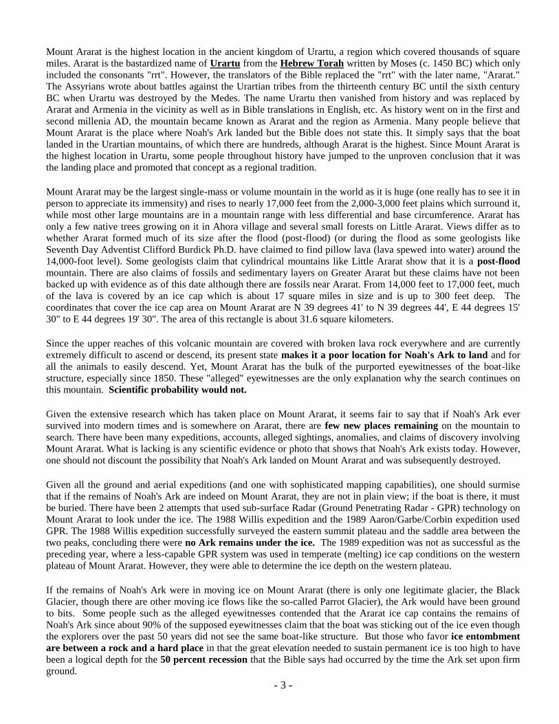
Mount Ararat (16,940 feet, 5165 m) is the largest volcano in Turkey. Although not currently active, its formation was
probably within the last 10,000 years. It is located in extreme northeastern Turkey, near the borders with Iran and
Armenia. Southeast of the main peak some 7 miles lies Little Ararat (12,877 feet, 3896 m). Ahora Gorge is a
northeast-trending chasm dropping 6000 feet from the top of the mountain and was the focus of a major earthquake
(and eruption) in 1840. A number of claims by different explorers of having found remnants of Noah‟s Ark on Mt.
Ararat have led to continuing expeditions to the mountain, many of which have focused their searches on the gorge
area and its overhanging glacier above the 14,000 foot level. The snow shown here is at and above the 2,600 meter
level. (8,500 feet). Only the upper cone of Mount Ararat supports permanent snow.
This extraordinary aerial view, looking northeasterly, is taken in late winter or early spring. Both volcanic peaks are
clearly visible, as are several volcanic vents common in the area. The main peak itself is in the center and Little
Ararat to the right, southeast of the main peak. Both are volcanoes. On the north-northwest flank, we see two other
more recent vents. Straight above Ararat‟s summit is a gash extending toward the top of the view, which is the
Ahora Gorge, formed by an 1840 Mount St.Helens scale eruption which blew out the side of the cinder-cone. The
townsite from which the gorge got its name once stood where the thousands of feet deep gorge is now located.
What is particularly noteworthy in this view are those two obvious half-mile wide places where the volcanic ash has
slumped. In the ashmounds around the two vents on Ararat‟s north face we see two separate dishes where the ash,
formed from these two vents, became saturated to the point where they slumped downward, sending massive slides
of material out into the valley. These demonstrate the same phenomenon that (at the Durupinar Site) carried the Ark
down valley several hundred vertical feet from the place where it originally landed, burying it until exposed by an
earthquake in May of 1948. A similar volcanic ash deposit around the Ark, formed after its landing, but while it was
still structurally sound, the ash became saturated and then when agitated by an earthquake, slumped like wet
concrete, creating a mudflow that carried the Ark remains more than a mile laterally and some 1,200 feet vertically.
The Durupunar Ark Site, where much interest has been focused since its aerial photo discovery in 1959, is out of the
frame, across the valley towards the bottom.

- 5 -
A view into the Ahora Gorge from the Armenian side, looking south-southwesterly.
At the Durupinar Site near the Ark Visitor‟s Center we see the Ark form in an early spring morning. The pointed
„bow‟ is higher than the collapsed „stern‟. Note the smooth cinder cone just above the center of the ship in this view.

- 6 -
A similar view to the previous one, but with different lighting conditions and from slightly higher in elevation, allows
us to note the slide path the Ark followed in its descent to where it became impaled on a narrow limestone rock
outcropping. The original landing site was up against the low cliffs in the grassy area at the base of the higher cliffs
in the top center of the photo, just above the smooth mound. An impression of the ship remains at that upper site
along with remains of slag ballast and evidences of wood torn from the underside of the hull. From the top center of
the photo, the Ark slid to the left, around the small mound, then towards us, then again slightly to the left. Erosion
has scarred what used to be a smooth grassy hillside prior to the 1948 earthquakes that also caused the soils around
the hull to slump, where that inside of it didn‟t.
This location is known as the Durupinar Site which is also recognized by the Turkish Government and where the
Noah‟s Ark Visitor Center is located, near the village known today as Uzengili, but prior to the 1940‟s was known as
Nasar (Nisir). The ridgeline is the mountain known as Cudi Dagi, or Al Judi. Though unsubstantiated, other than by
traditional accounts, the Durupinar Site is reported to be the actual Mount Cudi. One substantiating clue is the 13th
century French Knights Templar who claimed to have known of the Ark Site, and who commissioned a painting of a
location they called Mount Cordu, a scene bearing striking similarity to the ridgeline in this view of the Ark
impression. This site lies across the valley from Mount Ararat, lying some 15 miles to the west of it.
What is notable about this ship-like formation is its perfect symmetry and proportion. This is best seen in the straight
down shots such as in the 1959 negative image. That symmetry is broken only by a spear of rock extending into the
right side of the impression, buckling open the vertical timbering as would a moving boat shaped structure being
impaled upon a rock and twisting, as apparently happened.
Another characteristic, better seen from straight down, when shadows are right, which they were when the high level
photo was taken in 1959, is the image of a crowned figure lying in repose turned slightly to the right. See the inset in
the frame on page 13 and on page 19.

- 7 -
Another view similar to the previous two, but late-day in early summer with different lighting which better shows the
long straight „spear‟ of limestone which penetrates into the hull shape to a point just short of its longitudinal center-
line. Not only is the envelope symmetrical, but within the shape the ground is mounded symmetrically and possesses
a ridgeline longitudinally down the center. In later earthquakes, about 1979, this ridgeline cracked and split along its
near full length, suggesting there is or was an internal structure forming a plane of weakness, being almost 90 degrees
perpendicular to the impaling limestone outcrop.
As the straight down photos show, and to some degree visible from this hillside, an image is apparent which appears
like a crowned figure lying in a casket, turned slightly to his right. This image may account for the name change of
the nearby village of Nasar to Uzengili, which loosely translated means „Little Boogeyman‟. At the point of the
outcropping, just left of center, is a protrusion of rock resembling a heart. This protrusion is exactly where a heart
would be in the human figure.
Numerous ancient historic narratives, including the Epic of Gilgamesh and Josephus, describe habitable cities whose
primary function was that of a necropolis (burial cities). Researcher David Deal located both of these cities, one
above and the other down at the Durupinar site. Naxuan above and Seron below. Further excavation discovered
ossuary jars containing bones of ancient burials, suggesting they had been brought there from some distance away
and at some later date. We should keep in mind that Noah lived another 350 years after the flood. He died shortly
before Abram was born, and his son Shem died 150 years after Abram was born and 50 years after Isaac was born!
Post flood generations regarded the patriarch Noah as „an immortal‟, looking to him as a world „spiritual leader‟.
Resentment of this apparent situation is what precipitated the mutilation we read of in Genesis 9:24 on the part of
Ham‟s son, Canaan.
Visit these websites for additional information: www.noahsark-naxuan,com and www.noahsarksearch.com
- 8 -
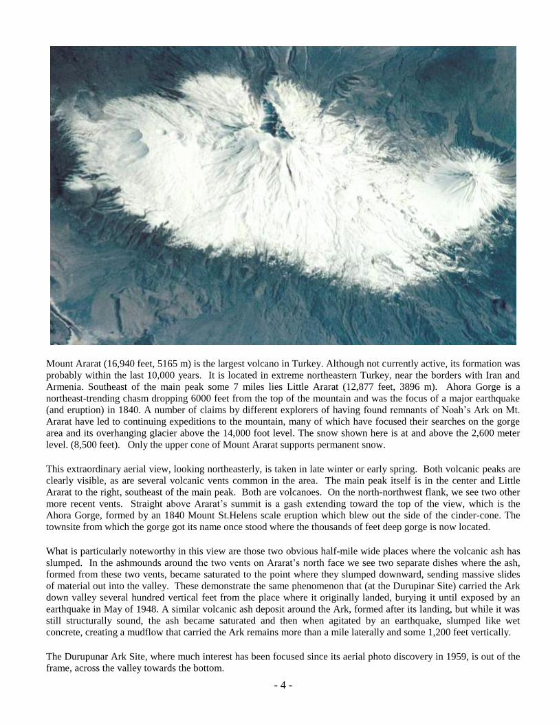
Tying the Durupinar Ark Site to its proximity to Mount Ararat, this view taken from the pointed bow of the ship form
looking toward the north-northeast viewing both greater Ararat and Little Ararat lying southeast of it. A man stands
on the right hand side, giving some scale to the picture. At our feet, we see the converging lines of the pointed bow.
Just beyond in the near foreground is the „crown‟ and the „head‟. A more prominent „chest‟ mound rises beyond that,
with the top of the „heart shaped rock‟ protruding above the surface, and the rock spear extending toward it from the
left. A flared section of the vertical hull wall is visible beyond the spear, where the twisting motion of its impale-
ment caused it to buckle. A trace of the centerline crack, referred to with the previous picture, is visible in the lower
center of the frame. The three previous views were taken from various vantage points on the hillside to the left. The
Government‟s Noah‟s Ark Visitors Center is on the hillside out of view to the left with the road winding around to it.
This view of Mt. Ararat corresponds
to the view above, but is taken from
a more southerly location near the
Iranian border. Mt. Ararat is a 7,000
foot high cinder cone atop a 10,000
foot mountain ridge.
The valley floor is at the 3,000 foot
elevation leaving this mountain with
nearly 14,000 feet of vertical expos-
ure, more than most other mountains
of comparable height.
- 9 -
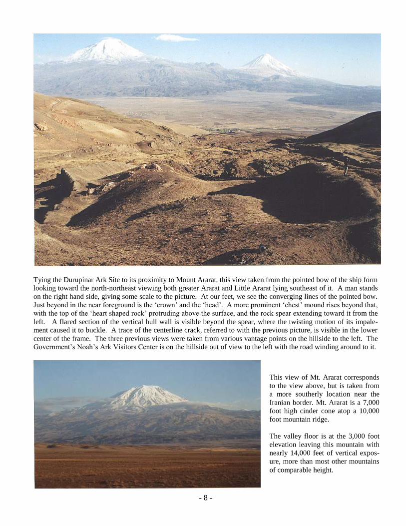
In this view, the photographer is standing at the very foot of the boat shaped formation, the exact reverse direction of
the upper view on the previous page. The „stern‟ falls-off and its substructure is somewhat folded under, which
would be very logical if the form had at some time slid down the valley in this direction. This view illustrates the
unusual symmetry of the longitudinal mound within the hull form. The near vertical nature of the surrounding hull
form is also clearly evident. The photo below illustrates the unmistakable regularity of vertical hull timbers. This is
not natural! As evident in 1959 photos, the left rim used to be as perfect as the right side.
This photo of the exposed side of the hull
very distinctly shows the coloration the
decayed (semi-petrified) rib timbers left in
the soil. These are not wood today, nor
would it be logical to expect wood to be still
present after 4300 years. Those who use the
presence of wood as the determining factor in
deciding any Ark find consign themselves to
never finding anything authentic, as wood in
the ground, exposed to moisture and oxygen
would‟ve decayed away completely long ago.
Note here the faint image of structural cross-
bracing on the surface. Diagonal timbers
would more logically have been placed inside
these hull ribs, and thus would have been less
distinct than these at the surface. Another
brace cuts in from the upper left corner!

- 10 -
From the previous page‟s upper photo, we are now up inside the hull area on the left side of the center mound,
showing the continuing symmetry of the mound. The absence of erosion within the hull, where there is considerable
erosion all around the exterior is curious. It would suggest that the internal contents are granular and more porous
than the surrounding soils. Had the hull filled with granular ash when it was higher up at the original landing
location, bringing its contents down with it when it slid in the mudflow, it would be consistent with other evidence.
The hull appears to be tilted slightly, with the left side elevated from the right. We see a jagged skyline on the left
where the remains of the hull timbers weathered away. (They were there in 1959.) On the right, they are more even.
Referring back to the previous photo, it is possible to visualize where the tops of timbers would once have been.
The left rear portion of the Ark
still bears evidence of vertical
ribs. One rib remains intact where
the sides have eroded away. This
area is just off the left of the upper
photo on page 9.
On the opposite (west) side of the
hull these same ribs are evident as
regular colorations in the face of
the hull „wall‟. (See the lower
photo on page 9)
The direction of slide would‟ve
created a more compacted soil
condition on the opposite side,
explaining less erosion there.
- 11 -
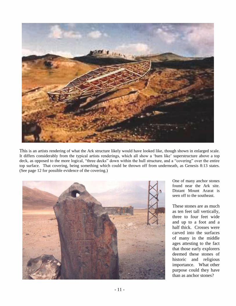
This is an artists rendering of what the Ark structure likely would have looked like, though shown in enlarged scale.
It differs considerably from the typical artists renderings, which all show a „barn like‟ superstructure above a top
deck, as opposed to the more logical, “three decks” down within the hull structure, and a “covering” over the entire
top surface. That covering, being something which could be thrown off from underneath, as Genesis 8:13 states.
(See page 12 for possible evidence of the covering.)
One of many anchor stones
found near the Ark site.
Distant Mount Ararat is
seen off to the southeast.
These stones are as much
as ten feet tall vertically,
three to four feet wide
and up to a foot and a
half thick. Crosses were
carved into the surfaces
of many in the middle
ages attesting to the fact
that those early explorers
deemed these stones of
historic and religious
importance. What other
purpose could they have
than as anchor stones?

12
Another noteworthy oddity found in the Ararat region is this unusual formation. Observers, noting its flat „bark-like‟
texture, speculate that it may be part of the “covering” removed from the Ark by Noah toward the end of the
recession period. One possibility is that the covering was formed by sticks tied as lath to the roof structure and
covered with multiple layers of coarse cloth saturated with and covered with „pitch‟, not unlike built-up roofing on
modern flat roofed buildings. Such a covering would be light weight, and could be removed from the underside. A
slab of such covering, settling into and covered by silt, then petrifying, could have created this formation. Note how
the striations end abruptly at certain points, which stick lath would be expected to do.
Another view of the „bark-like slab shows uniform parallel striations, but with a faint „Byzantine cruciform‟ carved
into the surface, as was done on the faces of the several local „anchor stones‟, suggesting explorers in the Crusader
era recognized the religious significance of this object. It may be they who inverted it!
13
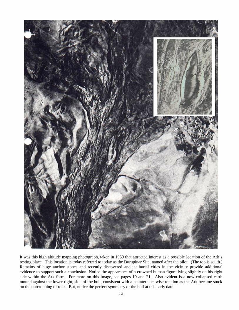
It was this high altitude mapping photograph, taken in 1959 that attracted interest as a possible location of the Ark‟s
resting place. This location is today referred to today as the Durupinar Site, named after the pilot. (The top is south.)
Remains of huge anchor stones and recently discovered ancient burial cities in the vicinity provide additional
evidence to support such a conclusion. Notice the appearance of a crowned human figure lying slightly on his right
side within the Ark form. For more on this image, see pages 19 and 21. Also evident is a now collapsed earth
mound against the lower right, side of the hull, consistent with a counterclockwise rotation as the Ark became stuck
on the outcropping of rock. But, notice the perfect symmetry of the hull at this early date.
14
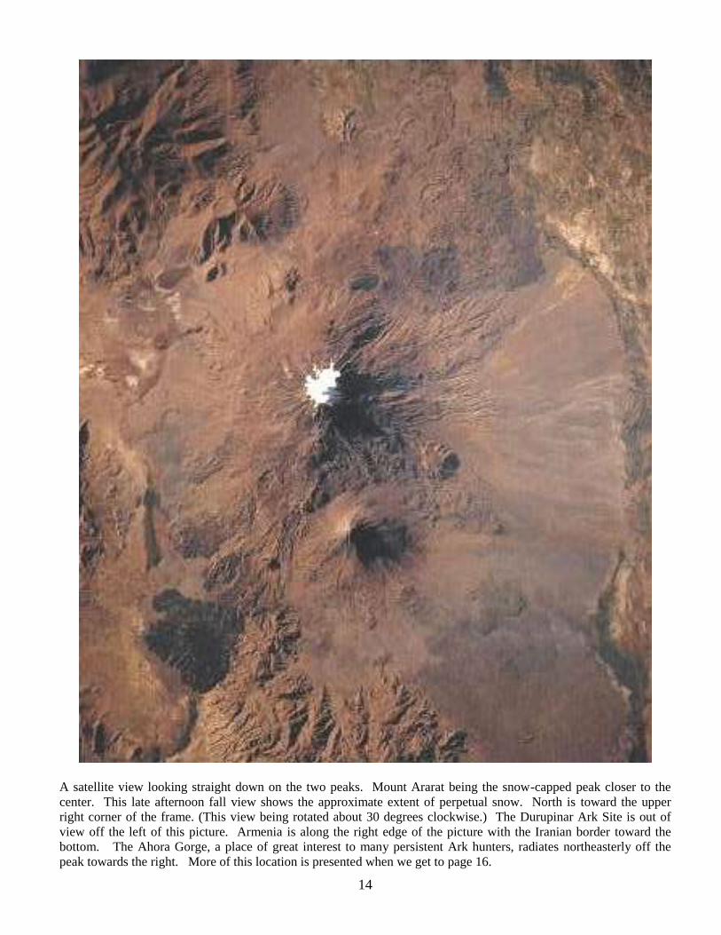
A satellite view looking straight down on the two peaks. Mount Ararat being the snow-capped peak closer to the
center. This late afternoon fall view shows the approximate extent of perpetual snow. North is toward the upper
right corner of the frame. (This view being rotated about 30 degrees clockwise.) The Durupinar Ark Site is out of
view off the left of this picture. Armenia is along the right edge of the picture with the Iranian border toward the
bottom. The Ahora Gorge, a place of great interest to many persistent Ark hunters, radiates northeasterly off the
peak towards the right. More of this location is presented when we get to page 16.
15
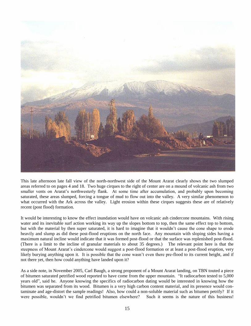
This late afternoon late fall view of the north-northwest side of the Mount Ararat clearly shows the two slumped
areas referred to on pages 4 and 18. Two huge cirques to the right of center are on a mound of volcanic ash from two
smaller vents on Ararat‟s northwesterly flank. At some time after accumulation, and probably upon becoming
saturated, these areas slumped, forcing a tongue of mud to flow out into the valley. A very similar phenomenon to
what occurred with the Ark across the valley. Light erosion within these cirques suggests these are of relatively
recent (post flood) formation.
It would be interesting to know the effect inundation would have on volcanic ash cindercone mountains. With rising
water and its inevitable surf action working its way up the slopes bottom to top, then the same effect top to bottom,
but with the material by then super saturated, it is hard to imagine that it wouldn‟t cause the cone shape to erode
heavily and slump as did these post-flood eruptions on the north face. Any mountain with sloping sides having a
maximum natural incline would indicate that it was formed post-flood or that the surface was replenished post-flood.
(There is a limit to the incline of granular materials to about 35 degrees.) The relevant point here is that the
steepness of Mount Ararat‟s cindercone would suggest a post-flood formation or at least a post-flood eruption, very
likely burying anything upon it. It is possible that the cone wasn‟t even there pre-flood to its current height, and if
not there yet, then how could anything have landed upon it?
As a side note, in November 2005, Carl Baugh, a strong proponent of a Mount Ararat landing, on TBN touted a piece
of bitumen saturated petrified wood reported to have come from the upper mountain. “It radiocarbon tested to 5,000
years old”, said he. Anyone knowing the specifics of radiocarbon dating would be interested in knowing how the
bitumen was separated from its wood. Bitumen is a very high carbon content material, and its presence would con-
taminate and age-distort the sample readings! Also, how could a non-soluble material such as bitumen petrify? If it
were possible, wouldn‟t we find petrified bitumen elsewhere? Such it seems is the nature of this business!
16
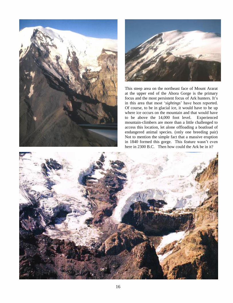
This steep area on the northeast face of Mount Ararat
at the upper end of the Ahora Gorge is the primary
focus and the most persistent focus of Ark hunters. It‟s
in this area that most „sightings‟ have been reported.
Of course, to be in glacial ice, it would have to be up
where ice occurs on the mountain and that would have
to be above the 14,000 foot level. Experienced
mountain-climbers are more than a little challenged to
access this location, let alone offloading a boatload of
endangered animal species. (only one breeding pair)
Not to mention the simple fact that a massive eruption
in 1840 formed this gorge. This feature wasn‟t even
here in 2300 B.C. Then how could the Ark be in it?

17
Based on reported sightings, artists produced this drawing of the Ark encased in glacial ice. Why it is that peoples‟
cameras never worked, or that experienced mountain climbers never thought to bring a camera, especially when their
intention for climbing was to locate the Ark, defies logical explanation.
Of course, none of the eyewitnesses could ever see more than just a small section protruding from the ice, so this
artist took liberty to draw the rectangular barge shape popular with most people. (At least, the artist broke away from
the stereotypical rendering by showing three decks down inside the hull, not above a top deck.) Such a square-end,
rectangular shape for any ship on open seas would have been self destructive. Without a rounded bottom and without
pointed ends, the structure would have been subjected to massive racking forces on any but perfectly calm waters.
Just the idea of the Ark in such a location still being intact is ludicrous. Anyone knowing the dynamics of glacial
formation will realize that they must continually move, or else they‟d accumulate to massive depths. Massive depth
alone would force the ice to move. Any glacier on an incline will move! These proposed locations are all on very
steeply inclining planes. What causes glacier formation is when annual snowfall exceeds annual melting. The
remainder builds over time and when thick enough, will exert pressure, causing the mass to flow downward like a
slow-moving river where the lowest extremities will melt. Being replenished annually on top with new snowfall, the
glacier will build to a relatively constant depth. Even though appearing stationary, glaciers are still in motion
internally. A perfect example is the mysterious disappearance of the flight of the Stardust in 1947, which fifty years
later began disgorging plane bits out of the bottom of a „stationary‟ glacier. The plane apparently struck a snow
cornice just above a glacier in the Andes, burying itself, and then was processed thru the glacier internally. (This
story was featured on NOVA on PBS. Go to www.pbs.org/wgbh/ nova/transcripts/2802vanished.html )
Snow cover, in the process of becoming glacial ice, compresses to less than an eighth of its original depth, subjecting
anything within it to enormous crushing forces. To suggest that a wooden structure with open interior spaces could
be anything less than squashed flat after forty three centuries in a glacier defies scientific fact. In addition, to suggest
that wood could still exist, being near enough to the surface to be seen in occasional years, without long ago decaying
away or being ground up within the glacier, also defies logic. We‟re talking about a wood structure older than the
pyramids!

18
This is an enlargement of the air view on page 4 of the summit and north side of Mount Ararat showing three
calderas. The one at the summit and two to the north (left) of the summit, the lower two formed in a smooth mound
of volcanic ash which they very probably created. What is revealing about these calderas is their obvious roundness
and the evenness of their perimeters. If the ¾ mile wide caldera at the summit were to have been flooded above its
top, as the water rose to the summit, the rim would have begun to erode at the lowest point on the rim as water rushed
in to fill it. When the water receded it would have spilled out through that same low point in the rim causing it to
erode like a dam breaking, eroding the rim even further in the process of the caldera emptying.
The absence of evidence of this happening, not on the high caldera and not the two lower ones, is evidence that these
cones had to have been formed after the recession. This tells us that there were significant eruptions after the flood.
That being the case, if the Ark were to have landed on the upper portion of Mount Ararat, it most likely would have
been buried by ash or lava from one of these eruptions. (There is even a good possibility that the upper cindercone of
Ararat wasn‟t even there when the water receded!) This burial is what appears to have happened across the valley at
the Durupinar Site. Ashfall from the nearby Tendurek formation covered the area, then liquefying, probably during
an earthquake, it collapsed and slurried down the slopes, carrying the Ark with it.
Being that the ash mound on the north side of Ararat was formed after the flood, we can know that the ground
saturation that caused the two landslides on the north side of the mound are also post-flood occurrences. Now, as to
the stories of sightings of the Ark remains being in ice, which is the most prevalent tale, to be in ice, it would have to
be on the north or eastern face, where due to sun shadow, is the side where glacial ice is able to be perpetual. With
the volcanic activity of the summit caldera and the two to the north, had the Ark landed there, it would have been
subject to ash burial, earthquakes and that massive explosive eruption of 1840 that created the gorge on the northeast
side visible in the upper right. Amazingly, this gorge area remains a prime area of focus of most Ark Hunters today!
19
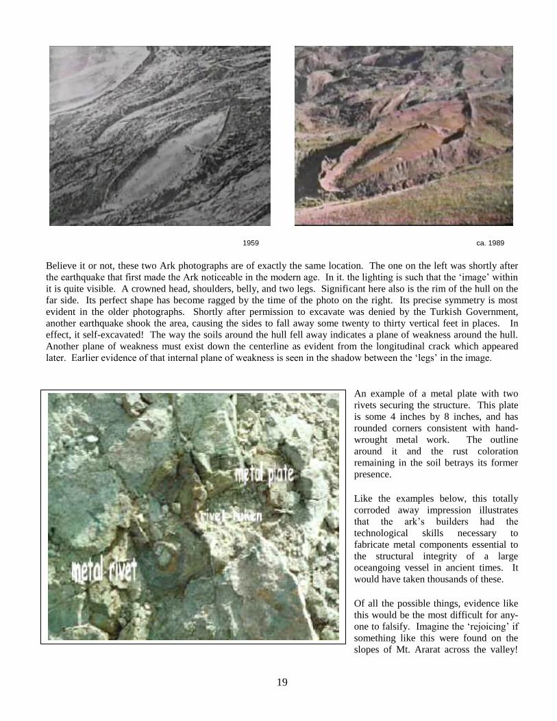
1959 ca. 1989
Believe it or not, these two Ark photographs are of exactly the same location. The one on the left was shortly after
the earthquake that first made the Ark noticeable in the modern age. In it. the lighting is such that the „image‟ within
it is quite visible. A crowned head, shoulders, belly, and two legs. Significant here also is the rim of the hull on the
far side. Its perfect shape has become ragged by the time of the photo on the right. Its precise symmetry is most
evident in the older photographs. Shortly after permission to excavate was denied by the Turkish Government,
another earthquake shook the area, causing the sides to fall away some twenty to thirty vertical feet in places. In
effect, it self-excavated! The way the soils around the hull fell away indicates a plane of weakness around the hull.
Another plane of weakness must exist down the centerline as evident from the longitudinal crack which appeared
later. Earlier evidence of that internal plane of weakness is seen in the shadow between the „legs‟ in the image.
An example of a metal plate with two
rivets securing the structure. This plate
is some 4 inches by 8 inches, and has
rounded corners consistent with hand-
wrought metal work. The outline
around it and the rust coloration
remaining in the soil betrays its former
presence.
Like the examples below, this totally
corroded away impression illustrates
that the ark‟s builders had the
technological skills necessary to
fabricate metal components essential to
the structural integrity of a large
oceangoing vessel in ancient times. It
would have taken thousands of these.
Of all the possible things, evidence like
this would be the most difficult for any-
one to falsify. Imagine the „rejoicing‟ if
something like this were found on the
slopes of Mt. Ararat across the valley!

20
Recent finds such as these metal fittings found within the Ark should prove to the skeptics the
authenticity of the Durupinar Ark find. Only those hardened religious opinionates who continue
to insist that only their long-held presumption of the Ark being up on Mount Ararat itself, up in
the ice on its upper cinder-cone, is correct, seem to be compelled to discount everything posed as
evidence. It is their persistent and adamant ‘faithful-to-their-narrowed-beliefs’ approach that may
end up doing more to harm their professed cause of verifying the scriptural account than anything
could. If their version of proving the Bible rests with an authentic ‘locate’ only on their preferred
mountain, and if in fact the Ark isn’t there (and science and logic says it couldn’t be), what else
could it do but undermine belief, both of the religiously inclined and also any the secular world
might be persuaded to have regarding this matter?
This startling find, of a 3-1/2 inch diameter
petrified iron rivet and washer should by itself
provoke great interest in the site. We can
clearly see the 1-1/4 inch rod peened over onto
the washer, but then the washer being peened
back into the shaft illustrates even more
incredible workmanship!
The metal plate shown above, still in place in
the hull with similar hammer work as this rivet
and washer is equally spectacular. Though it’s
more likely that the shape of the plate is
rounded at the corners rather than angular as
the overlay indicates, more consistent with
hand wrought work, this and other evidence of
metal fittings used to connect timbers in the
construction of the Ark is hard to dismiss.
21
Considering a Curious Postnote
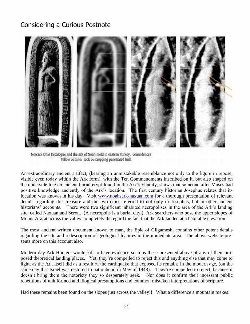
An extraordinary ancient artifact, (bearing an unmistakable resemblance not only to the figure in repose,
visible even today within the Ark form), with the Ten Commandments inscribed on it, but also shaped on
the underside like an ancient burial crypt found in the Ark‟s vicinity, shows that someone after Moses had
positive knowledge anciently of the Ark‟s location. The first century historian Josephus relates that its
location was known in his day. Visit www.noahsark-naxuan.com for a thorough presentation of relevant
details regarding this treasure and the two cities referred to not only in Josephus, but in other ancient
historians‟ accounts. There were two significant inhabited necropolises in the area of the Ark‟s landing
site, called Naxuan and Seron. (A necropolis is a burial city.) Ark searchers who pose the upper slopes of
Mount Ararat across the valley completely disregard the fact that the Ark landed at a habitable elevation.
The most ancient written document known to man, the Epic of Gilgamesh, contains other potent details
regarding the site and a description of geological features in the immediate area. The above website pre-
sents more on this account also.
Modern day Ark Hunters would kill to have evidence such as these presented above of any of their pro-
posed theoretical landing places. Yet, they‟re compelled to reject this and anything else that may come to
light, as the Ark itself did as a result of the earthquake that exposed its remains in the modern age, (on the
same day that Israel was restored to nationhood in May of 1948). They‟re compelled to reject, because it
doesn‟t bring them the notoriety they so desperately seek. Nor does it confirm their incessant public
repetitions of uninformed and illogical presumptions and common mistaken interpretations of scripture.
Had these remains been found on the slopes just across the valley!! What a difference a mountain makes!
22
The History Channel Special on Noah’s Ark and Mount Ararat.
On occasion, the History Channel will re-present their hour-long documentary on the Ararat Region,
focusing primarily on the religious ark-hunters favorite locale, the Ahora Gorge area. Based largely on the
claims of a Mr. Hagopian, who claimed, as a child, to have been taken up to the ark site by his grandfather,
these „ark-researchers‟ (who have discounted more pertinent facts and information than perhaps any other
„science‟ so called), have placed great stock in these reported sightings. Never mind that absolutely NO
photographic evidence has ever been brought back from that location, nor is it commonly reported that the
Ahora Gorge is a very recent formation. A town of the same name was located where the gorge now
exists. Researchers get giddy if a piece of wood is found in their favored vicinity, disregarding the fact that
the area should be littered with two centuries-old wood, the wreckage of the townsite‟s buildings from the
1840 explosion that blew out the northeastern flank of the mountain.
The History Channel special makes brief mention of the Durupinar Site, but largely disregards its
evidence, conveniently failing to mention that the government of Turkey, convinced of the authenticity of
the findings and evidence there, maintains a „Noah‟s Ark‟ National Park at the location, since the late
1980‟s. Conveniently not mentioned also is the ancient writings which identify the location and the fact that
there were inhabited cities at the landing site. Something impossible at the 14,000 foot level necessary for
glacial ice entombment. The History Channel didn‟t even regard the physical dimensions of the Durupinar
hull to be worthy of mention, it being correct for the ark based on the Egyptian cubit, which would have
been appropriate, as that‟s what Moses was familiar with, the Hebrew cubit not having come into use that
early. Nor did they mention the evidence of ancient habitation found in the Durupinar vicinity.
What piques the interest of some ark researchers is the presence of „secret‟ spy photo evidence held in the
CIA Archives of what is called „the Ararat Anomaly‟, but located on a different facet of the mountain.
Without noting the fact, that IF true, this barge shaped mass, perched high on a precipice, with glacial ice
built-up behind and above it, completely trash-cans the Hagopian claims, (without much reaction) which
have kept their hopes in a dead horse alive for so long. And, for some unexplainable reason, it hasn‟t been
possible to get near enough to this „anomaly‟ to determine whether it is a „boat‟ or just a natural rock
outcropping, though it‟s in plain sight, and an easier climb than is the Ahora Gorge area.
A puzzle that needs explanation is why Noah would drop so many of his anchor stones, acknowledged in
the documentary, at an elevation of 7000 feet, when the Ark supposedly landed at 14,000 feet. (To be in
„glacial‟ ice. That would mean there was 7,000 feet of water below the Ark when they were dropped! (If
the proposed landing sites are correct.) Usually, anchor stones would be cut loose when they became
grounded and there was desire to drift toward a landing site. Also, the anchors are on the opposite side of
the mountain (up and over a 10,000 foot ridge) from the proposed landing sites on Ararat: either Ahora
Gorge or the so-called Anomaly.
Perhaps, under the onset of the effects of „Global Warming‟, with glaciers receding everywhere, we will
soon have the „evidence‟ laid bare that so many have sought for regarding answers on this mountain.
23
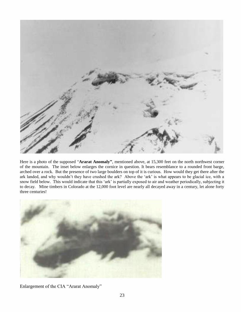
Here is a photo of the supposed “Ararat Anomaly”, mentioned above, at 15,300 feet on the north northwest corner
of the mountain. The inset below enlarges the cornice in question. It bears resemblance to a rounded front barge,
arched over a rock. But the presence of two large boulders on top of it is curious. How would they get there after the
ark landed, and why wouldn‟t they have crushed the ark? Above the „ark‟ is what appears to be glacial ice, with a
snow field below. This would indicate that this „ark‟ is partially exposed to air and weather periodically, subjecting it
to decay. Mine timbers in Colorado at the 12,000 foot level are nearly all decayed away in a century, let alone forty
three centuries!
Enlargement of the CIA “Ararat Anomaly”
24
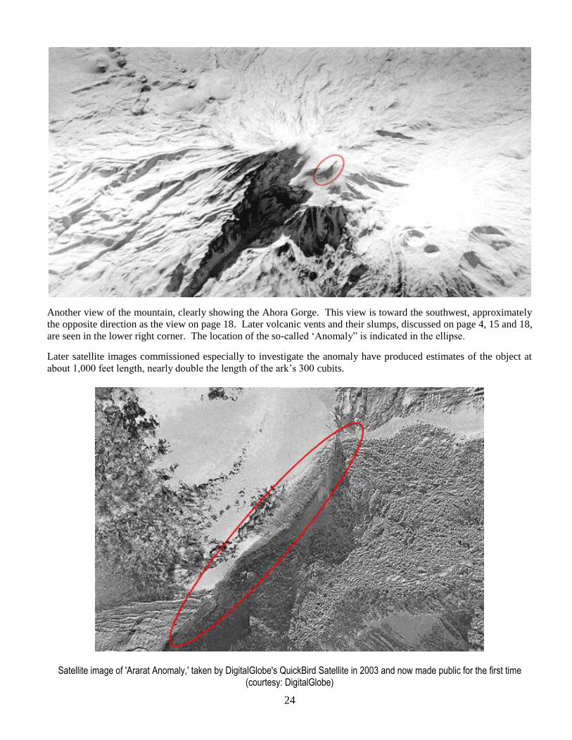
Another view of the mountain, clearly showing the Ahora Gorge. This view is toward the southwest, approximately
the opposite direction as the view on page 18. Later volcanic vents and their slumps, discussed on page 4, 15 and 18,
are seen in the lower right corner. The location of the so-called „Anomaly” is indicated in the ellipse.
Later satellite images commissioned especially to investigate the anomaly have produced estimates of the object at
about 1,000 feet length, nearly double the length of the ark‟s 300 cubits.
Satellite image of 'Ararat Anomaly,' taken by DigitalGlobe's QuickBird Satellite in 2003 and now made public for the first time (courtesy: DigitalGlobe)


![THE BOUNDARIES OF URARTU/ARARAT - Noah’s Ark Search · 2009. 11. 22. · designation, Armenia, [the] more modern designation -- They can’t be precise. There is not a boundary](https://static.fdocuments.in/doc/165x107/61268c1cddc1a56bc9720800/the-boundaries-of-urartuararat-noahas-ark-search-2009-11-22-designation.jpg)