Forest Management to Minimize Landslide Risk
17
- 271 - XVI. FOREST MANAGEMENT TO MINIMIZE LANDSLIDE RISK by Raymond M. Rice 1/ Pacific Southwest Forest and Range Experiment Station 1. INTRODUCTION 1.1 Magnitude of Landslide Erosion Mass wasting is the dominant erosional process in most steep-sloped catchments. And the major mechanism in this process is the landslide (2, 6, 8, 19, 24, 25, 29). In this paper, unless explicitly stated to the contrary, the term "landslide" will be used in reference to debris avalanches and other forms of shallow failures. One of the consequences of landslides is the increase in sedimentation estimated as accounting for 25 percent of sediment load of the Eel and Mad River Basins (26), but may be as high as 50 percent. Why the uncertainty? The principal obstacle to the study of landslides is that, although the amount of material eroded may be large, storms that produce landslides occur only infrequently - in the order of only once every 6 or more years. A short-term experiment, therefore, is unlikely to measure landslide erosion together with other types of erosion. Typically, a landslide-producing storm imposes itself upon another experiment. And the investigator measures its effect in this experiment. The data from such studies demonstrate that landslides can produce substantial amounts of erosion. After a large storm, Dyrness (6) found about 0.75 landslides per km 2 i n a 61 km 2 drainage in Oregon. That represented erosion rate of about 1 000 metric tons per km 2 . As high as that rate may have been, the rate was five times greater in a 101-ha experimental basin within the drainage, which had 24.7 ha of recent small clearcuts and 6.3 ha of roads (7). 1.2 Types of Landslides Each of the various types of landslides is influenced to some degree by vegetation manipulation (27). Shallow slides, such as debris avalanches, however, are the ones most likely to be triggered by logging or destruction of the forest cover. They are the ones over which the forest manager can exert the most control (29). Less subject to control are deep-seated failures. Roads or tractor trails built for timber harvesting can trigger such failures when improperly placed on unstable terrain. 1 / Author is Principal Research Hydrologist at the Pacific Southwest Forest and Range Experiment Station (U.S. Forest Service, U.S.D.A.), Arcata, California, U.S.A.
Transcript of Forest Management to Minimize Landslide Risk

- 271 -
XVI.
FOREST MANAGEMENT TO MINIMIZE LANDSLIDE RISK
by Raymond M. Rice 1/
Pacific Southwest Forest and Range Experiment Station
1. INTRODUCTION
1.1 Magnitude of Landslide Erosion
Mass wasting is the dominant erosional process in most steep-sloped catchments. And the major mechanism in this process is the landslide (2, 6, 8, 19, 24, 25, 29). In this paper, unless explicitly stated to the contrary, the term "landslide" will be used in reference to debris avalanches and other forms of shallow failures.
One of the consequences of landslides is the increase in sedimentation estimated as accounting for 25 percent of sediment load of the Eel and Mad River Basins (26), but may be as high as 50 percent. Why the uncertainty? The principal obstacle to the study of landslides is that, although the amount of material eroded may be large, storms that produce landslides occur only infrequently - in the order of only once every 6 or more years. A short-term experiment, therefore, is unlikely to measure landslide erosion together with other types of erosion. Typically, a landslide-producing storm imposes itself upon another experiment. And the investigator measures its effect in this experiment. The data from such studies demonstrate that landslides can produce substantial amounts of erosion. After a large storm, Dyrness (6) found about 0.75 landslides per km2 in a 61 km2 drainage in
Oregon. That represented erosion rate of about 1 000 metric tons per km2. As high as that rate may have been, the rate was five times greater in a 101-ha experimental basin within the drainage, which had 24.7 ha of recent small clearcuts and 6.3 ha of roads (7).
1.2 Types of Landslides
Each of the various types of landslides is influenced to some degree by vegetation manipulation (27). Shallow slides, such as debris avalanches, however, are the ones most likely to be triggered by logging or destruction of the forest cover. They are the ones over which the forest manager can exert the most control (29). Less subject to control are deep-seated failures. Roads or tractor trails built for timber harvesting can trigger such failures when improperly placed on unstable terrain.
1/ Author is Principal Research Hydrologist at the Pacific Southwest Forest and Range Experiment Station (U.S. Forest Service, U.S.D.A.), Arcata, California, U.S.A.

- 272 -
Fig. 1. Stability of a slope is determined by slope angle, geology and moisture conditions. The slope angle (S) determines the partitioning of the force of gravity (G) into a downslope component (E) that promotes failure and a component (F) that promotes stability
Fig. 2. Landslides often occur at the head of drainageways. These took place on a clearcut block in the Klamath Mountains, California.

- 273 -
1.3 Factors Related to Occurrence of Landslides
The factors that affect soil holding a single tree on a steep slope are many (Fig. 1). The slope angle S determines the partitioning of the force of gravity G into a downslope component E that promotes failure and a normal component F that promotes stability (through its effect on the frictional resistance to sliding along CD).The resistance to sliding at CD is governed by the soil, geology, and moisture conditions at that surface. If the potential failure is at the interface between the soil and parent material, the gross roughness due to stratigraphy or jointing of the parent material surface will also affect frictional resistance.
Cohesion of the soil tends to prevent movement. Generally, cohesion increases as the soils become more finely textured. Counteracting this tendency the cohesion of fine textured soils is greatly reduced as the soil moisture increases. Soil saturation will also, by creation of high pore water pressures, "float" the potential failure block (ABCD) on the surface (CD). If this zone of saturation is confined below an impermeable stratum, such as a B horizon, very high pore water pressure can result. The tree growing on ABCD promotes stability in two ways. It decreases soil water by transpiration, and its roots mechanically tie the potential failure block ABCD to stable portions of the slope. The lateral anchoring to the sides and upslope ABCD probably adds more to stability than roots tying it to the parent material beneath. It is principally this connection between slope , stability and tree roots that associates landslide occurrence to root decay following logging.
Slope is probably the key factor related to the occurrence of landslides. Slides can only occur when slopes are steep enough for some other factors to combine and produce a stress that exceeds the resistance of the soil or rock material making up the slope.
Other factors related to the occurrence of landslides are physiography, soil and geology, climate; vegetation, and disturbances. Since some disturbance is an inevitable part of forest management activities, it is usually safe to assume that they will increase landslide risk.
2. APPRAISAL OF LANDSLIDE RISKS
2.1 Physiography
2.1.1 Slope
Analyses on granitic terrane have shown that slope "explained" from 44 to 77 percent of the influence of site on the occurrence of landslides (21). Mudflows have been reported on slopes as flat as 3º (4) and debris avalanches have occurred on slopes as steep as 60º (25 ). Slopes between 30º and 40º seem to be the most frequent sites for landslides. Neglecting the effect of stratigraphy, for the moment, the slope at which landslides occur increases as soil texture becomes coarser. Therefore, the critical slope (the slope above which nearly all landslides occur) is much steeper on granitic terrane which typically has a coarse textured soil than where the parent material is basalt, which typically developes finely textured soil.
2.1.2 Position in relation to drainages
Since excess moisture is almost always associated with landslides, most failures occur in drainages or adjacent to stream channels. A variable indicating whether the contours were convex or concave (in plan view) accounted for about 20 percent of the variability of occurrence of landslides (21). In profile, the most frequent site for landslides seems to be just below a convex break in slope at the head. of a small drainage (Fig. 2). This coincidence of landslides and drainage pattern indicates that the subsurface drainage is generally parallel to surface drainage, but there is evidence to suggest that this is not
- 274 -
necessarily the case. In site appraisal, consideration should be given to the areas where it is expected that subsurface water will concentrate rather than relying solely on surface contours.
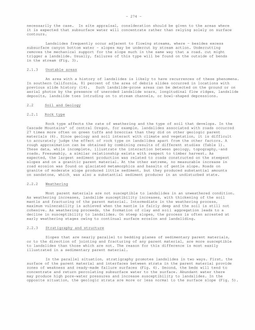
Landslides frequently occur adjacent to flowing streams, where - besides excess subsurface canyon bottom water - slopes may be undercut by stream action. Undercutting removes the mechanical support for the slope much in the same way that a road. cut might trigger a landslide. Usually, failures of this type will be found on the outside of bends in the stream (Fig. 3).
2.1.3 Unstable areas
An area with a history of landslides is likely to have recurrences of these phenomena. In southern California, 81 percent of the area of debris slides occurred in locations with previous slide history (14). Such landslide-prone areas can be detected on the ground or on aerial photos by the presence of uneroded landslide scars, longitudinal flow ridges, landslide deposits, landslide toes intruding on to stream channels, or bowl-shaped depressions.
2.2 Soil and Geology
2.2.1 Rock type
Rock type affects the rate of weathering and the type of soil that develops. In the Cascade Mountains" of central Oregon, for example, landslides associated with roads occurred 27 times more often on green tuffs and breccias than they did on other geologic parent materials (6). Since geology and soil interact with climate and vegetation, it is difficult to accurately judge the effect of rock type on landslides apart from the other factors. A rough approximation can be obtained by combining results of different studies (Table 1). These data, while incomplete, illustrate the interaction between geology, topography,-and roads. Presumably, a similar relationship exists with respect to timber harvest. As expected, the largest sediment production was related to roads constructed on the steepest slopes and on a granitic parent material. At the other extreme, no measurable increase in road erosion was found on glaciated metamorphics and basalts of gentle slope. Roads on granite of moderate slope produced little sediment, but they produced substantial amounts on sandstone, which. was also a substantial sediment producer in an undisturbed state.
2.2.2 Weathering
Most parent materials are not susceptible to landslides in an unweathered condition. As weathering increases, landslide susceptibility increases, with thickening of the soil mantle and fracturing of the parent material. Intermediate in the weathering process, maximum vulnerability is achieved when the mantle is fairly deep and the soil is still not cohesive. As weathering proceeds, the formation of clay and soil aggregation leads to a decline in susceptibility to landslides. On steep slopes, the process is often arrested at early weathering stages owing to continual surface erosion and landsliding.
2.2.3 Stratigraphy and structure
Slopes that are nearly parallel to bedding planes of sedimentary parent materials, or to the direction of jointing and fracturing of any parent material, are more susceptible to landslides than those which are not. The reason for this difference is most easily illustrated in a sedimentary parent material.
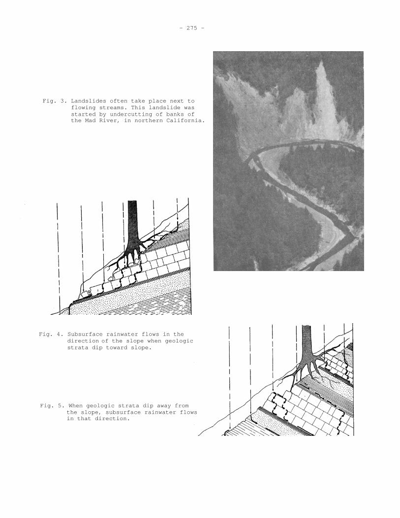
In the parallel situation, stratigraphy promotes landslides in two ways. First, the surface of the parent material and interfaces between strata in the parent material provide zones of weakness and ready-made failure surfaces (Fig. 4). Second, the beds will tend to concentrate and return percolating subsurface water to the surface. Abundant water there may produce high pore-water pressures and increase susceptibility to landslides. In the opposite situation, the geologic strata are more or less normal to the surface slope (Fig. 5).
- 275 -
Fig. 3. Landslides often take place next to flowing streams. This landslide was started by undercutting of banks of the Mad River, in northern California.
Fig. 4. Subsurface rainwater flows in the direction of the slope when geologic strata dip toward slope.
Fig. 5. When geologic strata dip away from the slope, subsurface rainwater flows in that direction.

Location
Soil parent material
Slope
Type of vegetation
Sedimentation on Deposition
Years Sampled
Average amount of materialremoved for the period Undisturbed Disturbed
Ratio Disturbed/ Undisturbed
Refer- ence
Pct. Metric tons/sq. km./yr.
Idaho Granite 70 Pinus ponderosa
6
8.8 396 45.2 (16) Deposition in dams in small ephemeral drainages
Oregon Sandstone 20-50 Psuedotsugamenziesii
1 Approx. 42 94 2.2 ( 5) Suspended sedi- ment from watersheds
Colorado 30-40 10-14 2.2 (2/)
0.0 (15)
Glaciated Metamorphics
Pinus Contorta Abie lasiocarpa
Deposition in dams in perennial drainages
Idaho Granite 35-55 4-5 0.0 1.2 -- (10) Pinus ponderosa
Deposition in sediment dams in ephemeral and perennial stream
Oregon 20-30 4 (3/) -- (4/)
Glaciated basalts
Psuedotsuga menziesii
Average <10 ppm
Suspended sedi- ment at gaging station
Oregon Tuffs and 55 Psuedotsuga
menziesii 2 25.6 56 2.2 ( 7)
breccias
Suspended sedi- ment and bedloads from watersheds
1/
-276-
Source: (22) 1/Assumed sediment volume weight of 70 pounds per cubic foot 2/Slight increases traced to roads but not significant 3/No change except slight increase during road construction 4/Unpublished data on file at Pacific Northwest Forest and Range Experiment Station, Corvallis, Oregon.
Table 1. Erosion and Sedimentation from Logging Roads in the Western United States, by Location, Soil, Slope, Vegetation Type

- 277 -
Because weaknesses in the bedding planes of the geologic formation are normal to the direction of failure, they contribute little to failures. Such slopes are also more stable because the strata tend to direct water away from the surface rather than concentrating it there.
2.3 Climate
Climate determines the type of storm that will be required to trigger a landslide. In humid climates, the soil mantle may be in a barely stable condition throughout much of the year. In such situations, only a relatively short period of above-normal rainfall is necessary to trigger failures. For example, diurnal rainfall of 50 mm was sufficient to release earthslides in the Torentrask-Narvik area of northern Norway and Sweden (19). At the other extreme, in southern California, Bailey (1) places a rainfall threshold at about 460 mm in 12 days on coarse-textured soils that were rarely above field capacity.. The storm in Norway would occur about once every 6 years; the storms in California, once every 8 years.
Just what is the critical climatic event will depend on two factors: the rainfall regime, and how rapidly moisture can drain from the soil. The more slowly moisture can drain from the soil, the more susceptible slopes will be because they will carry over from storm to storm. Except for permafrost environment the temperature regime has little to do with the relative importance of landslides as an erosional process. Landslides can be as important an erosional process in a sub-arctic environment (19) as in tropical areas (24).
2.4 Vegetation
Although vegetation may increase susceptibility to landslides (25), most evidence suggests that the more vegetation on a site the lower is its susceptibility to landslides. An example of this condition, although not in a forest type, shows landslide occurrence inversely correlated with size and density of vegetation (Table 2) (3). The only deviation from that trend was in the riparian zone; where, in spite of heavy vegetation, the disturbing influence of the stream caused more landslides than in other less dense parts of the chaparral. Another exception to this inverse correlation between landslides and vegetation was found in a freshly burned area (Table 3), which had only 62 percent of the landslide erosion measured in the area that had not burned for 49 years. Apparently, a freshly burned area is spared some landslide erosion because low infiltration rates prevent sufficient water from entering the soil to trigger landslides. At the same time, soil in such an area is fully supported by the roots of the former vegetation.
Table 2: Percent of Area of Vegetation Types that Slipped on the Bell Canyon Watershed San Dimas Experimental Forest, California (1966-1967) 1/
Vegetation Type Area in Slips
Sage and barren 23.9
Perennial grass 11.9
Annual grass 6.5
Riparian woodland 5.3
Chamise chaparral 3.3
Oak chaparral 2.6
Broadleaf chaparral 1.2
Source: (3)
1/ Average slope of study areas ranged from 55 to 59 percent

- 278 -
Table 3: Effect of Fire and Type Conversion on Landslides during 1969 Storms, San Gabriel Mountains, California 1/
Landslides Vegetative Cover Year Burned m3/ ha
Grass 2/ 1960 844
Chaparral 1960 298
Chaparral 1919 16
Chaparral 1968 10
Source: (20)
1/ Average slope of study areas ranged from 55 to 59 percent 2/ Converted after fire
Within a given size of plants, species may be an indicator of the likelihood of landsliding. Bailey (2) has found that Populus tremuloidies was an indicator of instability. This species favoured wet sites and could propagate itself by layering if its roots were torn by movement. These two characteristics gave it a competitive advantage over other species and caused it to dominate areas which were creeping or susceptible to landslides.
Pioneer species of all types may indicate landslides since they would be the first to invade landslide scars or deposits. Creep often precedes landslide failures, therefore, tilted trees may indicate prior movement - especially if the tilts are in differing directions.
One common landslide indicator - but of doubtful value - is curved tree trunks. In the deciduous forests of the eastern United States, no evidence has yet been found to substantiate the contention that curved tree trunks indicates soil creep (18). A curved tree trunk could indicate soil creep, a landslide, or the potential for a landslide, but on steep slopes most of the forces against the trunk are downslope.
3. EFFECT OF CUTTING TREES
3.1 Changes in Evapotranspiration
A mature forest depletes soil moisture at a near maximum rate. After a timber harvest, therefore, the soil moisture regime will be greatly altered. During most of the year, soil on cutover lands will have higher moisture content than that on forested lands (Fig. 6). Generally, the drier the climate, the more important will be the role played by differences in soil moisture depletion between forested and cutover lands. If both a forested and a clearcut area are near field capacity during most of the year, the effect of the timber harvest may be negligible.
As far as landslides are concerned, it is the amount and duration of the deficit which are important. If the period of deficit does not extend into the portion of the rainy season when landslide producing storms are most likely to occur (Fig. 7), then differences in soil moisture may be of little practical consequence. If deficit period coincides with the period of maximum landslide stress (Fig. 8), then the soil moisture depletion effect of the timber harvest may be crucial and lead to substantially more landslides in a clearcut area. As regrowth occurs, the soil moisture depletion effect

Fig. 6. Idealized representation of soil moisture cycle in forested and clearcut areas. (9)
Fig. 7. Idealized soil moisture deficit which does not coincide with period of landslide producing storms.
Fig. 8. Idealized soil moisture deficit which coincides with landslide producing storms.

- 280 -
diminishes. Its duration will depend upon the vigour and density of the vegetation that follows the timber harvest.
3.2 Root Decay
Under most circumstances, most of the increase in landslides after timber harvest can be attributed to decrease in the strength of the slope resulting from root decay. Kitamura and Namba (12, 13) indexed the contribution of tree roots to slope strength by the force required to uproot stumps and trees. The force required to uproot a stump declined rapidly after harvest, but there were species differences - presumably related to decay resistance of the roots (Fig. 9). Cryptomeria japonica was the best for the prevention of landslides; Larix leptolepsis was intermediate, and Pinus thunbergii was the least effective species.
3.3 Regrowth of Vegetation
3.3.1 Seedlings
The uprooting resistance of seedlings and young trees that develop after a timber harvest vary only slightly among species - especially in the early years (Fig. 9) (12, 13). This finding seems reasonable since the mechanical differences between species would not become apparent until root systems were nearly completely developed and substantial amounts of heartwood had been created.
3.3.2 Sprouts
In a sprouting species, it seems likely that the pattern just described would be altered. In addition to a decline in strength from the stumps which die after harvest and an increase in strength from seedling reproduction, there would be added a strength regime of stumps which coppiced. These stumps presumably would enter into a brief period of decline while the root systems atrophied in response to the cutting. A period of rapid recovery of strength would follow as sprouts develop. Just how much effect sprouting might have on total slope strength would depend on the proportion of stumps which sprouted.
3.4 Net Slope Strength
Uprooting resistance does not necessarily equal the contribution of roots to slope strength, but presumably the two are closely correlated. To estimate the net trend of slope strength by adding resistance curves from both stumps and reproduction would probably be an oversimplification. Nonetheless, it would be instructive to do so because it highlights even more markedly the differences in slope strength due to differing species and cutting systems (Fig. 10).
Whether the greater vulnerability of one species over another is of practical importance depends upon where a critical resistance threshold appears on the ordinate. If landslides are very unlikely unless the net uprooting resistance drops below two, then the difference between species would be of little importance. If, on the other hand, the critical value were four we would find for example, that P. thunbergii was vulnerable to landsliding after harvest but C. japonica was not (Fig. 10). If the threshold were at six, both species would have a period of vulnerability but that of C. japonica would be shorter. Storms that can produce stresses equal to the lower resistance values are more frequent than those that can overcome the higher resistance values. This phenomenon tends to accentuate the importance of differences among tree species (Fig. 10).

- 281 -
Fig. 10. Inferred net strength of slopes supporting different tree species.
Fig. 9. Inferred forest contribution to slope strength related to species and time since harvest. (17)
Fig. 12. Hypothetical trends in slope strength under shelterwood management and selection management.
Fig. 11. Inferred effect of a 5-year delay in regenerating a Pinus thunbergii clearcut.

- 282 -
4. EFFECT OF SILVICULTURE SYSTEM
4.1 Clearcutting
As far as landslides are concerned, clearcutting is the least desirable silvicultural system because strength is reduced simultaneously over the whole harvest area. In an extensive inventory covering over 12 000 km2 in Japan, more than 10 000 individual landslides were tallied. The volume of soil moved was nearly 2.5 times greater on the areas supporting even-aged plantations than it was on areas supporting natural forests or mixed forests (17). These findings support the admonition that even-aged, single-species management should be avoided on potentially unstable slopes.
Another reason for avoiding clearcutting where landslide risk exists is the effect on slope strength of any delay in achieving prompt regeneration. A 5-year delay in securing regeneration P. thunbergii illustrates this point (Fig. 11). Not only is the period of vulnerability extended but also the minimum strength is reduced.
4.2 Shelterwood System
Landslide risks resulting from even-aged management can be reduced by turning from a clearcutting system to a shelterwood system. Hypothetical curves show net slope strength when the first harvest of a non-sprouting species removes a volume equivalent to half of the forest's contribution to slope strength and second cutting, 10-years later, removes the remaining volume (Fig. 12). This cutting system achieves two desirable objectives: (a) increasing the minimum strength, and (b) reducing the duration of vulnerability for any resistance threshold.
4.3 Selection System
If we assume five evenly spaced cuts over the rotation age of the forest, we find that a selection system will weaken in slope strength only slightly (Fig. 12). Clearly it is the best system for potentially unstable areas if there are no other adverse considera-tions. If a selection system required the use of tractors for yarding, it could have greater adverse effect on slope stability than could even-aged management with yarding accomplished by cable systems.
4.4 Coppice Management
With any silvicultural system, a species which will sprout can probably maintain slope strength at a high enough level so that the removal of trees during the harvest will cause only a trivial increase in landslide risk. This would be true only if management of the stand is prudent and maintains high levels of growing stock. In the inventory study in Japan (17), among the various forest conditions, the most, landslides were found in the "poor coppice forest."
5. EFFECT OF OTHER FOREST MANAGEMENT ACTIVITIES
5.1 Roads
In most circumstances, roads more frequently cause landslides than do timber harvests. Roads gouge deeply into subsoil and parent material; logging disturbance is generally restricted to the soil surface. Road cuts can remove downslope support that was buttressing potentially unstable areas. Roadfill material may be deposited on slopes barely strong enough to support the weight of the existing mantle. Roadcuts intercept subsurface water and may channel it to areas which are unable to cope with the additional flow. For these reasons we find frequent references to the importance of roads.

- 283 -
During the 1964-65 floods, 72 percent of the landslides on an experimental forest in Oregon were associated with roads (6) - although roads occupied only 1.8 percent of the area. This intensity of landsliding was 315 times greater than that found in undisturbed portions of the experimental forest. Landsliding in the logged portion was only 10 times greater than undisturbed conditions.
Similar results have been reported for forests elsewhere. Roads were involved in 60 percent of the damage to National Forests of Washington and Oregon after the 1964-1965 floods (23). In southern Idaho, 90 percent of the failures studied were associated with roads (11). In Oregon, a single road failure produced 40 percent of the total sediment yield for the year from a 303-ha drainage containing 4 km of roads constructed to permit clearcut logging of about 25 percent of the watershed (5). In all these cases roads had been constructed on steep slopes.
One of the most important ways that forest management can minimize landslide risk is to minimize road mileage and to the fullest extent possible, locate necessary roads on the more stable portions of the landscape.
5.2 Fire
The likely immediate effect of a fire is to reduce landslide risk (Table 3). As time passes, however, the roots of the former vegetation decay, and new vegetation restores infiltration. A burned area then becomes much more vulnerable to landsliding (Table 3). In total, the effect of a fire on landslide occurrence is quite like that of a clearcut timber harvest.
5.3 Conversion
The conversion of an area from woody vegetation to grass is the most hazardous vegetative manipulation that managers can undertake. If the terrain has an appreciable slope, it is safe to assume that some portion of its stability was due to the stabilizing effect of the roots of the woody vegetation. Consequently, increased erosion and increased landsliding are often associated with conversion (9, 21, 28). Conversions are especially hazardous because the herbaceous vegetation promotes rapid infiltration without lending appreciable mechanical support to the slope that was formerly dependent upon it. A conversion is like a clearcut with no regeneration (Fig. 9).
6. PREPARING MANAGEMENT PRESCRIPTIONS
6.1 Critical Slopes
In analysing landslide problems associated with a timber harvest, first prepare a slope map of the harvest area. Next, determine what is the lowest slope upon which landslides have occurred in the past. Group all slopes flatter than its lowest one into a single slope class that presumably presents no landslide risk. In actuality, some landslides will occur in this area. Because smoothing necessarily accompanies the mapping process, small steep facets will be incorporated in areas that have much flatter slope on maps. In a 1969 study (21), 2 percent of the landslides occurred in areas mapped as having slopes less than 28º - even though all slides measured were on slopes steeper than 31º .
If there are sufficient data about slopes on which landslides have been occurring, another slope class could be created. This class would include all areas steeper than those which experienced landslides. Normally, such areas will be found to be rock outcrops or to contain a different, more stable geologic formation. If adequate data are not available to define this slope, however, it is better to assume that landslide risk increases with slope. Finally, subdivide the slopes considered susceptible to landsliding into two or more slope classes. The number of classes will depend upon how much of the harvest area is susceptible to landslides and variation in susceptibility. These critical slope classes will then be the focus of further attention in attempts to minimize landslide losses.

- 284 -
6.2 Soil and Stratigraphic Considerations
In areas where soil surveys or intensive geologic mapping has been done, the data compiled can be used to supplement slope information in appraising relative landslide hazard. But before final plans are made, all susceptible areas should be inspected on the ground.
Undoubtedly, circumstances will arise that will make it necessary to cross steep slopes with new roads used for the harvest. If this can be done on soils which are characteristically stable or on areas where the bedding planes are nearly normal to the surface, losses from landslides may be reduced. Even within a geologic formation, there may be subunits exceeding average stability. To the extent that distrubance can be concentrated on those units and reduced on others, the adverse effects of the harvest can be minimized.
6.3 Expected Stress
If data on the types of storms that have led to landsliding are available, they should be used to estimate the recurrence interval of those storms. This information could be useful in predicting the likelihood of a storm during the vulnerable period after a timber harvest. If such information is lacking, a return period between 5 and 10 years should be assumed, using lower values for humid climates and higher ones for more arid climates.
6.4 Potential Losses
6.4.1 Loss of productivity
For each landslide-producing event, between 2 and 6 percent of a harvest area will likely be bared by landslides (6, 7, 21). From data on tree rings, Fujiwara (8) estimated that from 10 to 15 years were required for vegetation to cover landslide scars in Japan. He found that north and east facing slopes recovered almost twice as rapidly as dry south and west slopes.
To appraise the total loss in productivity, the manager should base his estimate on the product of the expected number of landslide-producing storms, the damage expected from each storm, and the loss of growth from the landslide area until they revegetate. In most cases, landslide scars, even after revegetating, will not be as productive as undisturbed soil.
6.4.2 Damage to other values
Related amenities are often as important as the timber resources. Questions to be considered are: Will accelerated landslides from the timber harvest block transportation routes or increase their maintenance costs? Will sediment entering streams damage a valuable fisheries resource? Will wildlife values be damaged? Will the appearance of the area be so degraded as to create political pressures which will inhibit the effective operation of the managing agency?
6.5 Resources Gains from Management
Normally, an area would not be considered for harvest unless it contained valuable wood products. These are usually the most important benefits derived from forest harvesting operations. Other benefits might be the financing of a transportation system needed for other management purposes, the enhancement of wildlife values by creating more open and diverse cover, or increases in streamflow.

- 285 -
6.6 Balancing Gains and Losses
Attempts to appraise the danger of landslides in an area are fraught with uncertainty because of the random nature of storms. This would be true even if the forest manager knew with a high degree of certainty the several parameters that affect landslide risks. His role is to balance potential losses against potential gains. In so doing, he gains a number of benefits. One is a form of self-discipline that helps insure that the desirability of a timber harvest is examined objectively. In such an examination, the ratio of benefits to costs must be considered. Another benefit is that a forest manager who has a firm techno-logical base is in a better position to withstand political pressures that are often brought to bear on management decisions. And he is better equipped to arrive at sound decisions about what can or should be done to minimize landslide risks.
7. REFERENCES
(1) Bailey, R.G. Soil slips on the San Dimas Experimental Forest. M.A. thesis on file 1967 at San Fernando State College, Northridge, California.
(2) Bailey, R.G. Landslide hazards related to land use planning in Teton National 1971 Forest, northwest Wyoming. USDA Forest Service, Intermountain
Region. 131 pp.
(3) Bailey, R.G., and Rice, R.M. Soil slippage: an indicator of slope instability on 1969 chaparral watershed of southern California. Prof. Geog. 21(3): 172-177.
(4) Beaty, C.B. Landslides and slope exposure. J. Geol. 64: 70-74. 1956
(5) Brown, George W., and James T. Krygier. Clearcut logging and sediment production in 1971 Oregon Coast Range. Water Resources Research 7(5): 1189-1198.
(6) Dyrness, C.T. Mass soil movement in the H.J. Andrews Experimental Forest. USDA 1967 Forest Service Research Paper PNW-42, 12 p. Pacific Northwest Forest
and Range Experiment Station, Portland, Oregon.
(7) Fredriksen, R.L. Erosion and sedimentation following road construction and timber 1970 harvest on unstable soils in three small western Oregon watersheds.
USDA Forest Service Research Paper PNW-104, 15 p. Pacific Northwest Forest and Range Experiment Station, Portland, Oregon.
(8) Fujiwara, Koichiro. A study of the landslides by aerial photographs. Hokkaido 1970 University, College Exp. Forests, Research Bull. 27(2): 343-345.
(9) Gray, Donald H., and R. Peter Brenner. The hydrology and stability of cutover 1971 slopes. Proc. Symp. on Interdisciplinary aspects of watershed
management, Bozeman, Montana Aug. 1970: 295-326.
(10) Haupt, H.F., and W.J. Kidd. Good logging practices reduce sedimentation in central 1965 Idaho, J. Forestry 63:664-670.
(11) Jenson, F., and G. F. Cole. Unpublished report on file at the Payette National 1965 Forest, McCall, Idaho.
(12) Kitamura, Toshikazu, and Senshi Namba. A field experiment on the uprooting resistance 1966 of tree roots (I). Proc. 77th Meeting of the Japanese Forestry
Society. 1966:568-570.

- 286 -
(13) Kitamura, Yoshikazu, and Senshi Namba. A field experiment on the uprooting resistance 1968 of tree roots (II). Proc. 79th Meeting of the Japanese Forestry
Society. 1968: 360-361.
(14) Kojan, Eugene, G.T. Foggin III, and R. M. Rice. Prediction and analysis of debris 1972 slide incidence by photogrammetry, Santa Ynez-San Rafael Mountains,
California. Proc. 24th International Geological Congress, Montreal, Canada. 1972, Sec. 13: 124-131.
(15) Leaf, C.F. Sediment yields from high mountain watersheds, central Colorado. USDA 1966 Forest Service Research Paper RM-23, 15 p., Rocky Mountain Forest and Range Experiment Station, Fort Collins, Colorado.
(16) Megahan, W.R., and W.J. Kidd. Effects of logging and logging roads on erosion and 1972 sediment deposition from steep terrain. J. Forestry 70(3): 136-141.
(17) Nakano, Hidenori. Soil and water conservation functions of forest and mountainous 1971 lands, the research at Government Forest Experiment Station. Forest
Influences Division (Japanese) Government Forest Experiment Station, 14. 66 p.
(18) Phipps, R.L. The soil creep - curved tree fallacy. J. Research U.S. Geol. Survey 1974 2(3): 371-377.
(19) Rapp, A. Recent development of mountain slopes in Karkevagge and surroundings, 1960 northern Scandinavia. Geografiska Annaler 42:65-200.
(20) Rice, R.M. The hydrology of chaparral watersheds. Proc. Symp. on Living with the 1974 Chaparral, Riverside, California 1973:27-34.
(21) Rice, R.M., and G.T. Foggin. Effect of high intensity storms on soil slippage on 1971 mountainous watersheds in southern California. Water Resources
Research 7(6): 1485-1496.
(22) Rice, R.M., J.S. Rothacher and W.S. Magahan. Erosional consequences of timber 1972 harvesting: an appraisal. Proc. National Symp. on Watersheds in
Transition, Fort Collins, Colorado, 1972: 321-329.
(23) Rothacher, J.S., and T.B. Glazebrook. Flood damage in the National Forests of 1968 Region 6. USDA Forest Service Pacific Northwest Forest and Range
Experiment Station, Portland, Oregon. 20 p.
(24) Simonett, David S. Landslide distribution and earthquakes in the Bewani and 1967 Torricelli Mountains, New Guinea. Land form studies in Australia
and New Guinea, p.64-84. Australian National University Press.
(25) Swanston, Douglas N. Mass wasting in coastal Alaska. USDA Forest Service Research 1969 Paper PNW-83, 15 p. Pacific Northwest Forest and Range Experiment
Station, Portland, Oregon.
(26) U.S. Department of Agriculture. Water land, and related resources, north coastal 1970 area of California and portions of southern Oregon. Appendix No. 1
Sediment yield and land treatment, Eel and Mad River Basins. USDA- SCS, Portland, Oregon. 143 p.
(27) Varnes, D.J. Landslide types and processes. Special Report 29, Highway Research 1958 Board, Washington, D.C., p. 20-47.

- 287 -
(28) Wallis, J.R., and H.W. Anderson. An application of multivariate analysis to sediment 1965 network design. Int. Assoc. Sci. Hydrol. Publ. 67: 357-358.
(29) Zaruba, Quido, and Vojtech Mencl. Landslides and their control.205 p. New York; 1969 Elsevier Publ. Co.