FOREST FIRE VULNERABILITY ASSESSMENT STUDY · PDF fileForest Fire Vulnerability Assessment...
25
1 FOREST FIRE VULNERABILITY ASSESSMENT STUDY USING REMOTE SENSING AND GIS – A CASE STUDY IN TIRUPATTUR DIVISION DINKAR KUMAR, I.F.S. (District Forest Officer, Tirupattur, TAMILNADU - 635601) (E-mail: [email protected]) ABSTRACT Forest Fire has always remained a challenge for the forest managers. A no. of natural and manmade components decides the vulnerability of a forest area for fire. Often the field managers and the field staff, lack the basic information regarding fire occurrences, fire frequency, fire intensity, exact cause of fire and the vulnerable areas. The forest fire is dealt as and when it occurs and then forgotten. There is no fire vulnerability map to forecast or preparations done for future occurrences due to lack of scientific study in this regard. In this study, the MODIS satellite data which gives near real time data regarding forest fire along with other geographical data of the area in different layers in a Geographical Information System (GIS) platform is used to create fire vulnerability model and fire vulnerability map of an area. This map and the details therein give a fairly good idea of vulnerable areas and forest fire can be effectively managed by the use of this data. Use of Remote sensing technology and the knowledge of Geographical Information System facilitate combining different factors responsible for fire and creating maps showing vulnerable areas can be of immense help for the front line staff. KEY WORDS Forest fire, Remote sensing, Risk, Vulnerability, MODIS
Transcript of FOREST FIRE VULNERABILITY ASSESSMENT STUDY · PDF fileForest Fire Vulnerability Assessment...
1
FOREST FIRE VULNERABILITY ASSESSMENT STUDY USING
REMOTE SENSING AND GIS –
A CASE STUDY IN TIRUPATTUR DIVISION
DINKAR KUMAR, I.F.S.
(District Forest Officer, Tirupattur, TAMILNADU - 635601)
(E-mail: [email protected])
ABSTRACT
Forest Fire has always remained a challenge for the forest managers. A no. of natural and
manmade components decides the vulnerability of a forest area for fire. Often the field
managers and the field staff, lack the basic information regarding fire occurrences, fire
frequency, fire intensity, exact cause of fire and the vulnerable areas. The forest fire is
dealt as and when it occurs and then forgotten. There is no fire vulnerability map to
forecast or preparations done for future occurrences due to lack of scientific study in this
regard. In this study, the MODIS satellite data which gives near real time data regarding
forest fire along with other geographical data of the area in different layers in a
Geographical Information System (GIS) platform is used to create fire vulnerability
model and fire vulnerability map of an area. This map and the details therein give a fairly
good idea of vulnerable areas and forest fire can be effectively managed by the use of this
data. Use of Remote sensing technology and the knowledge of Geographical Information
System facilitate combining different factors responsible for fire and creating maps
showing vulnerable areas can be of immense help for the front line staff.
KEY WORDS
Forest fire, Remote sensing, Risk, Vulnerability, MODIS
Forest Fire Vulnerability Assessment Study using Remote Sensing And GIS – A Case Study in Tirupattur Division
2
INTRODUCTION
Forest fires are a ubiquitous phenomenon in Indian forests, and they probably date back
to the first arrival of people on the Indian subcontinent. Humans have long used fire as a
forest management tool, whether for hunting, to clear land for agriculture, to promote the
growth of fodder for grazing livestock, or to facilitate their collection of non-timber forest
products (NTFP). Forest fires cause major damage to the environment, human health and
property, and endanger life. It has long been held that such fires have been inseparably
connected with the development of woody vegetation and grasslands in India. However,
there is also recent evidence to suggest that natural fires in conjunction with grasslands
pre-dated human caused fires on the Indian subcontinent. Fires continue to be a
significant influence on Indian forests even today. At the end of the 19th century Dietrich
Brandis, the then Director General of the Indian Forest Service, had observed that half to
three quarters of mature trees in the plains and lower hills of India were hollow, and he
attributed this to fire. The government estimates were that 35 million ha of Indian forests
(~54%) are affected by fire annually. Forest fires are considered as a major and
permanent threat for the forests in Tamilnadu. Every year, forest fires cause enormous
and irreparable damage to forest ecosystems and in some cases threaten residential
regions. Forest fires can be ignited by a variety of reasons. The cause may be natural or
manmade, intentional or unintentional. There are many factors that contribute to an
increased fire risk, such as high temperatures and prolonged drought periods, the strong
winds, the configuration of the ground and the extremely flammable vegetation. Once a
forest fire has started, many factors contribute to its spread and intensity. Fuel – such as
leaves, needles, grass, branches, and logs, Weather, including temperature, humidity,
precipitation, and wind, Topography, or landscape of the area, as steep slopes offer
greater potential for increased fire intensity and more obstacles for fire fighting. Forest
fire causes imbalances in nature and endangers biodiversity. The menace has been
aggravated with rising human and cattle population and the consequent increase in
demand for Forest products by individuals and communities. Despite the widespread
occurrence of fires in Indian forests, we still lack precise information regarding fire
occurrence, fire frequency, fire intensity, and the exact causes of fire. Even though most
fires today are likely to be human-caused, the reasons could be manifold. By and large,
forest fires are linked to the benefits that people obtain from forests. To a lesser extent,
forest fires are linked to people’s religious beliefs or cultural practices. People have also

3
Forest Fire Vulnerability Assessment Study using Remote Sensing And GIS – A Case Study in Tirupattur Division
been known to use fires as a form of protest against restrictive forest policies. In addition,
forest managers use fire as a habitat management tool, for instance, to maintain
grasslands for herbivores. The Tamilnadu Forest Act of 1882 specifies setting of fire as a
punishable offence and it is mandatory for all forest dwellers to assist in the prevention of
fire. The National Forest Policy of 1988 has the same spirit although it lays greater
emphasis on the use of modern fire prevention tools while continuing to stress the
involvement of local communities in the prevention of fires. The essential goal has
remained the same over almost a century: to have forests free of the influence of fire.
Forest vulnerability to fire is defined in this study as the combination of the susceptibility
of a given area to natural and human-induced ignition, and the ease in which fire spreads
through an area once present. This working definition of forest fire vulnerability builds
off the work of Gonzalez et al. (2007) who identified natural variables such as slope,
aspect, vegetation type, and presence of surface water as significantly influencing
vulnerability. Anthropogenic variables such as increased proximity to roads and
recreational areas have also been identified as increasing the risk of forest fire ignition
(Sowmya and Somashekar, 2010). Other, more stochastic variables, such as lightening
strikes, wind patterns, and precipitation have also been found to significantly influence
forest fire vulnerability (Arienti et al., 2006). The variables identified above all
experience spatial variability in such a way that different forest landscapes exhibit unique
degrees of fire vulnerability. Therefore, the ability to successfully combine multiple
variables that influence forest fire vulnerability can be of assistance to forest managers as
well as any other stakeholder which is interested in the impacts of forest fire. For
effective Forest fire management early detection, monitoring and assessment is very
necessary. It depends on the terrain, aspect, available dry material and anthropogenic
pressure. All these variables may differ for different place and the degrees fire
vulnerability may also differ. The analysis of multiple variables in Geographical
Information Systems (GIS) environment is crucial for developing a model in evaluating
forests’ vulnerability to fire. GIS has the capacity to use these variables for evaluation
over wide geographical areas. The study of forest fire mapping is made easier by the
advent of MODIS data and active fire maps. The MODIS Active Fire Map provides a
near real-time geospatial overview of the current forest fire situation at regional and
national scales. Locations of current fires and the extent of previous fire activity are
ascertained using satellite imagery acquired by the MODIS sensor. These fire data are

Forest Fire Vulnerability Assessment Study using Remote Sensing And GIS – A Case Study in Tirupattur Division
4
integrated with various sources of contextual spatial data and information in a suite of
geospatial data and mapping products. The data and products provided by the program are
valuable for numerous fire-related applications. This information is utilized by fire
managers to assess the current fire situation and serves as a decision support tool in
strategic decisions regarding fire suppression resource allocation.
MATERIALS AND METHODS
Study Area
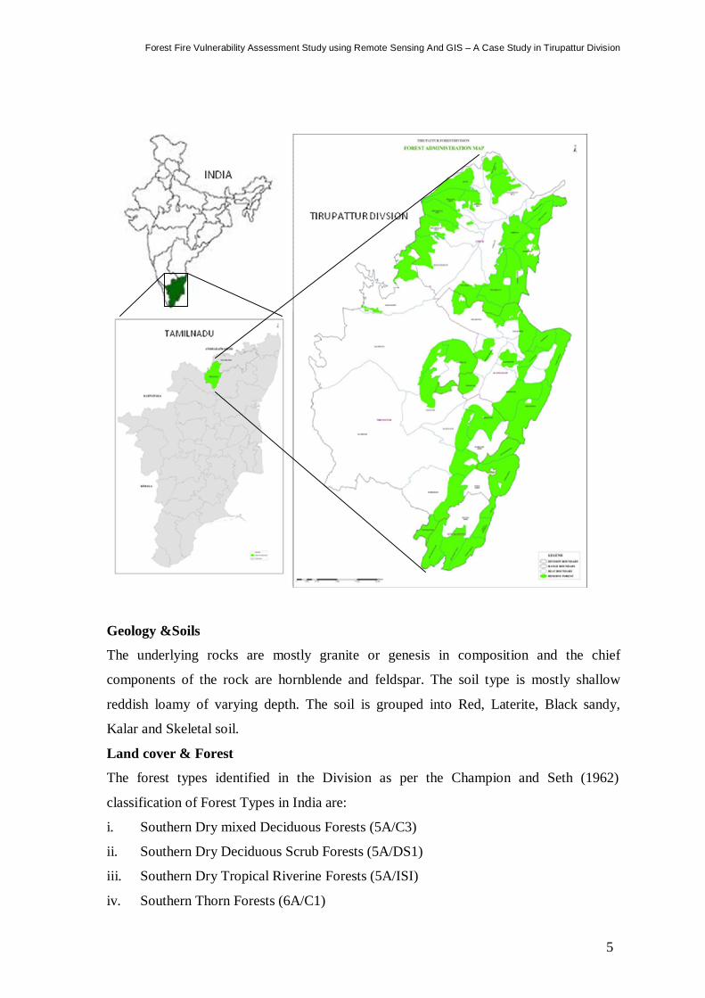
Tirupattur Forest Division is a territorial forest division in Tamilnadu, which is in the
southern part of Vellore district. This division is surrounded by Vellore forest division on
the North, Hosur forest divisions on the South, Tiruvannamalai North forest division on
the East and borders with Andhra Pradesh state on the west. The tract covered by this
division lies between North latitudes 12˚ 15’ 13” to 12˚ 55’ 25” and 78˚ 24’ 18” to 78˚
51’ 43” East longitudes. The tract is mainly grouped under two categories viz., the plains
and the hills. The plains are out ranges of Mysore plateau. The hills are divided into two
main blocks viz., the Javadhi hills and the Yelagiri hills. The Javadhi hills are steeply
forming an undulating plateau on the top about 800M above mean sea level. These are the
principal mountains of this division and runs from South West to North East with an area
of 570 Sq. Km. Yelagiri hills is a compact block with an area of 72 Sq. Km. The total
Reserved Forest (RF) area is 69233.15 ha and 3956.05 ha of Reserved Land (RL).
Drainage
Palar, Pambar and Malatar are the three rivers traversing in this division. The rain water
mainly drains into Palar and to Cheyar river which is a major tributary to Palar River. A
part of water drains into Pambar which is a major tributary to Ponnaiar River. These
rivers are not perennial.
Climate & Rainfall
There is a distinct variation in the climate between the Javadhi hills and plain land in the
division. The climate is little cooler on the western side and progressively warmer
towards East. During March – May it is very hot and gets cold after few summer showers.
On the hills the climate is milder and pleasant. The average temperate varies from 19º to
36˚C. The rainfall in this Division is evenly distributed. The average rainfall is 850mm to
900mm.
5
Forest Fire Vulnerability Assessment Study using Remote Sensing And GIS – A Case Study in Tirupattur Division
Geology &Soils
The underlying rocks are mostly granite or genesis in composition and the chief
components of the rock are hornblende and feldspar. The soil type is mostly shallow
reddish loamy of varying depth. The soil is grouped into Red, Laterite, Black sandy,
Kalar and Skeletal soil.
Land cover & Forest
The forest types identified in the Division as per the Champion and Seth (1962)
classification of Forest Types in India are:
i. Southern Dry mixed Deciduous Forests (5A/C3)
ii. Southern Dry Deciduous Scrub Forests (5A/DS1)
iii. Southern Dry Tropical Riverine Forests (5A/ISI)
iv. Southern Thorn Forests (6A/C1)
Forest Fire Vulnerability Assessment Study using Remote Sensing And GIS – A Case Study in Tirupattur Division
6
v. Southern Thorn Scrub Forests (6A/DS1)
vi. Tropical Dry Evergreen Forest-Carnatic Evergreen Forests(G7/C1)
vii. Tropical Dry Evergreen Forests – Hill Evergreen Forests (not classified)
viii. Tropical Dry Evergreen Scrub Forests (G7/DS1)
ix. Tropical Dry Semi Evergreen Forests – Plains Semi Evergreen Forests
x. (Not classified)Man made Forests (Plantation)
7
Forest Fire Vulnerability Assessment Study using Remote Sensing And GIS – A Case Study in Tirupattur Division
Objective
The objectives of this study are
1. To identify ‘fire sensitive area’ for Tirupattur Forest Division based on the fire
burnt area as assessed using Satellite Images, Past fire occurrences as reported
by field staff and MODIS fire data.
2. To map ‘fire vulnerable areas’ for Tirupattur Forest Division is based on spatial
distribution of past fire occurrences, Terrain, Vegetation type and
anthropogenic pressure.
Data used
Forest Administrative Layer (vector, polygon feature)
Forest fire data (2001 to 2011 except 2003) (raster)
Past fire occurrences as reported by field staff
Road Network (vector, Line feature)
Forest enclosures/settlements (vector, polygon feature)
Location of Villages (vector, point data)
Forest Type Map (raster)
MODIS fire data (geo coordinates)
DEM of Shuttle Radar Topography Mission (SRTM) data (raster)
Software used
ArcGIS
ERDAS Imagine
Approach
The approach for the study involves the following steps
Generation of required data from original data
Data processing
Data analysis and Map generation
Results and Discussions
Introduction to the Forest Fire Vulnerability Model
A Geographical Information Systems (GIS) and Remote Sensing technology based multi-
variable evaluation will be used to map fire vulnerable areas for Tirupattur Forest
Division. Terrain, vegetation type and human influence variables will be used to generate
Forest Fire Vulnerability Assessment Study using Remote Sensing And GIS – A Case Study in Tirupattur Division
8
a fire vulnerability map for the Reserved forests and Reserved lands of Tirupattur forest
division.
Landscape Variables
The landscape in a region can have several different impacts on a forest fire that may
increase or decrease the likelihood of ignition or spread. The landscape variables
considered in our study are slope, aspect, vegetation and proximity to road.
Aspect: Aspect is a key factor for forest fire ignition in a study area. For instance, in the
northern hemisphere a slope that faces south has a much higher vulnerability to fire than a
north facing slope. This is because the south facing slope is exposed to more sun radiation
throughout the day and thus these slopes are drier than north facing slopes. Therefore the
most vulnerable slopes are those that face south-west and the least vulnerable slopes are
those that face north-east. The aspect also affects the vegetation type that grows in the
area. The drier conditions of a southern facing slope generally provide more favourable
conditions for more vulnerable plant species to grow.
Slope: The slope is a factor in forest fire vulnerability analysis because as a slope
increases in steepness, the chance of fire spread is decreased and thus decreases
vulnerability. However, when slopes have a small inclination rate or there is no slope (the
land is flat) this increases the rate of spread and increases the fire vulnerability in the area
(Morvan, Dupuy, Porterie, & Larini, 2000). Slope also has strong correlation with the
direction of the fire. For instance, if a fire is moving up a slope it will spread much faster
than if the fire was travelling down slope. However, the rate of spread up and down
slopes will not be considered in our model. The slope will only be analysed in our model
to compare with level ground rates of spread.
Vegetation Cover i.e. Forest types: Vegetation is also a key factor in forest fire
vulnerability and spread. The fire ignition factor and the sustaining of fire in different
forest types are different. The dry grassland will be more vulnerable to fire than a moist
deciduous forest.
Proximity to Roads: Roads play both a positive and negative role in forest fire
vulnerability. When considering forest fire spread vulnerability, roads can actually aid in
containing the fire because roads can act as a fire break Another way roads can aid forest
fire spread is that they increase accessibility to the forested area, allowing fire control
staff easier access to it .Thus, forests in close proximity to roads will have a lower risk of
forest fire spread, but forests that are not in close proximity to roads have an increased
9
Forest Fire Vulnerability Assessment Study using Remote Sensing And GIS – A Case Study in Tirupattur Division
risk of forest fire spread (Arienti et al., 2006). When considering forest fire ignition
vulnerability roads play the opposite role and increase the risk of fire ignition because
they offer more human access to forested areas. This increased access to people, often
leads to more accidental ignition.
DATA PROCESSING AND MAP GENERATION
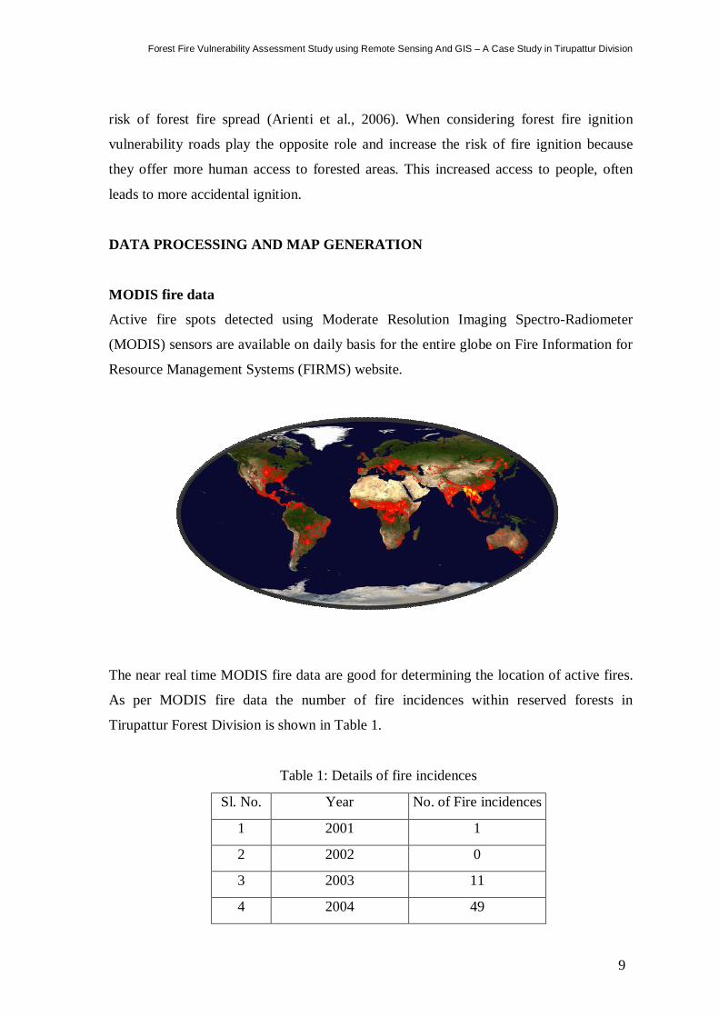
MODIS fire data
Active fire spots detected using Moderate Resolution Imaging Spectro-Radiometer
(MODIS) sensors are available on daily basis for the entire globe on Fire Information for
Resource Management Systems (FIRMS) website.
The near real time MODIS fire data are good for determining the location of active fires.
As per MODIS fire data the number of fire incidences within reserved forests in
Tirupattur Forest Division is shown in Table 1.
Table 1: Details of fire incidences
Sl. No. Year No. of Fire incidences
1 2001 1
2 2002 0
3 2003 11
4 2004 49
Forest Fire Vulnerability Assessment Study using Remote Sensing And GIS – A Case Study in Tirupattur Division
10
5 2005 44
6 2006 8
7 2007 15
8 2008 1
9 2009 4
10 2010 4
11 2011 9
Forest Fire field data
From the Forest fire field data, the forest fire burnt area in Tirupattur Forest Division for
the past 10 years is as shown in Table 2.
Table 2: Forest fire burnt area (year wise)
Sl. No. Year Burnt Area (in Ha)
1 2001 789.52
2 2002 367.32
3 2003 0
4 2004 0
5 2005 543.47
6 2006 674.24
7 2007 1315.81
8 2008 0
9 2009 74.46
10 2010 80.01
11 2011 70.21
Fire recurrence analysis is the first step towards fire control planning.
Using ERDAS Imagine software, the 10-year forest fire spatial data is aggregated and
analyzed to generate Fire Recurrence map as shown in Table 3.
11
Forest Fire Vulnerability Assessment Study using Remote Sensing And GIS – A Case Study in Tirupattur Division
Table 3: Details of fire recurrence
Sl. No Recurrence Area (in Ha)
1 Once 3202.73
2 Twice 343.29
3 Thrice 7.09
4 Four Times 1.79
Forest Fire incidents reported by Field staff
As per fire occurrences as reported by field staff, the number of fire incidences within RF
areas in Tirupattur Forest Division shown in Table 4.
Table 4: Actual fire occurrence
Sl. No. Year No of occurrence
1 2006 21
2 2007 8
3 2008 6
4 2009 20
5 2010 17
6 2011 15
Total 87
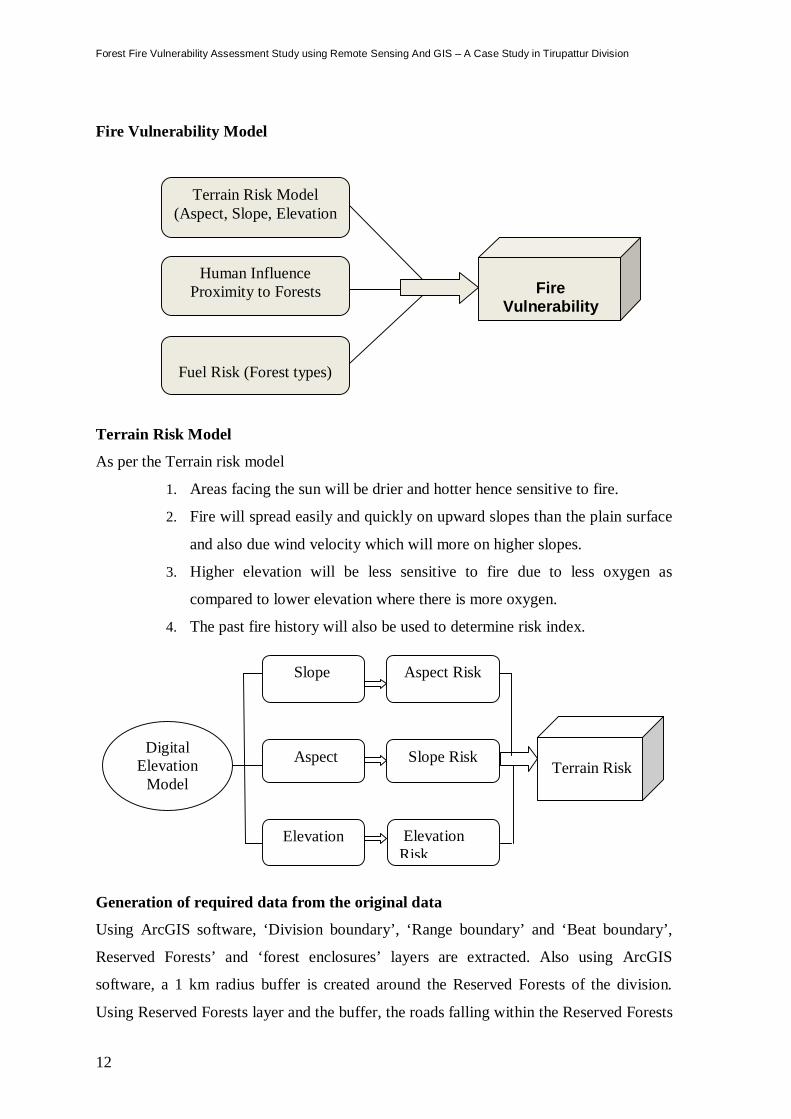
Forest Fire Vulnerability Model
The fire model is divided into three sub models namely Terrain Risk model, Human
Influence Model and Fuel Risk Model. The variables, the data layers chosen for the
creation of such models are comprehensively determining factors in Forest Fire. The
variables of every sub model are given quantitative fire risk values depending upon their
capacity to promote fire hazard. The terrain risk sub model has Aspect, Slope and
Elevation and past five histories as its components. Human influence risk has roads and
village location as its components. Fuel risk model has Forest Type as its components.
These models are combined to get the Fire Vulnerability Model.
Forest Fire Vulnerability Assessment Study using Remote Sensing And GIS – A Case Study in Tirupattur Division
12
Fire Vulnerability Model
Terrain Risk Model
As per the Terrain risk model
1. Areas facing the sun will be drier and hotter hence sensitive to fire.
2. Fire will spread easily and quickly on upward slopes than the plain surface
and also due wind velocity which will more on higher slopes.
3. Higher elevation will be less sensitive to fire due to less oxygen as
compared to lower elevation where there is more oxygen.
4. The past fire history will also be used to determine risk index.
Generation of required data from the original data
Using ArcGIS software, ‘Division boundary’, ‘Range boundary’ and ‘Beat boundary’,
Reserved Forests’ and ‘forest enclosures’ layers are extracted. Also using ArcGIS
software, a 1 km radius buffer is created around the Reserved Forests of the division.
Using Reserved Forests layer and the buffer, the roads falling within the Reserved Forests
Digital Elevation
Model (DEM
Aspect
Slope
Elevation
Aspect Risk
Slope Risk
Elevation Risk
Terrain Risk
Fire
Vulnerability Model
Terrain Risk Model (Aspect, Slope, Elevation
Human Influence Proximity to Forests
Fuel Risk (Forest types)

13
Forest Fire Vulnerability Assessment Study using Remote Sensing And GIS – A Case Study in Tirupattur Division
and around the Reserved Forests within 1 km distance are extracted from Divisional
‘Road Network’ layer to generate ‘forest roads’ layer. Using Reserved Forests layer and
its 1 km radius buffer, the villages falling within the Reserved Forests and around the
Reserved Forests within 1 km distance are extracted from Divisional ‘Location of
Villages’ layer to generate ‘forest villages’ layer. The MODIS fire data gives only point
location of centre of pixel in which fire occurred. It will not give the extent of fire burnt
area. Using Reserved Forests layer, location of fire spots falling within the Reserved
Forests are extracted from MODIS fire data to generate MODIS fire layer for each year.
Using ERADAS Imagine software, Aspect, Elevation and Slope maps for Tirupattur
Forest Division are generated using SRTM data. in raster format The forest enclosures,
forest roads, forest villages, division fire & MODIS fire layers are in vector format. These
maps/layers are the input data for vulnerability analysis. The 10 year forest fire data and
MODIS fire data are over-layed on Aspect, Elevation and Slope maps to assess and
identify fire sensitive aspects, elevation zones and slope zones. Dry matter availability is
one of the reasons for fire spreading. Forest type map is used to assess and identify fire
sensitive zones based on dry matter availability. In India, 99% of forest fire occurrence is
anthropogenic in nature. Public movement are generally more around forest enclosures,
forest villages and along forest roads. Buffer zones are created around forest enclosures,
forest villages and forest roads to assess and identify fire sensitive zones. To have proper
balance of effect of different factor which are causes of fire, weights are given after
dividing it into different fire sensitive zones like High, Moderate and Low.
Slope Risk:
Topographical factors have a large effect on the spreading speed of fire. The
steepness of slope has a great influence on the spreading of fire. The 11 year forest fire
data is over-layed on Slope Zone and fire occurrence on each Slope zone is studied.
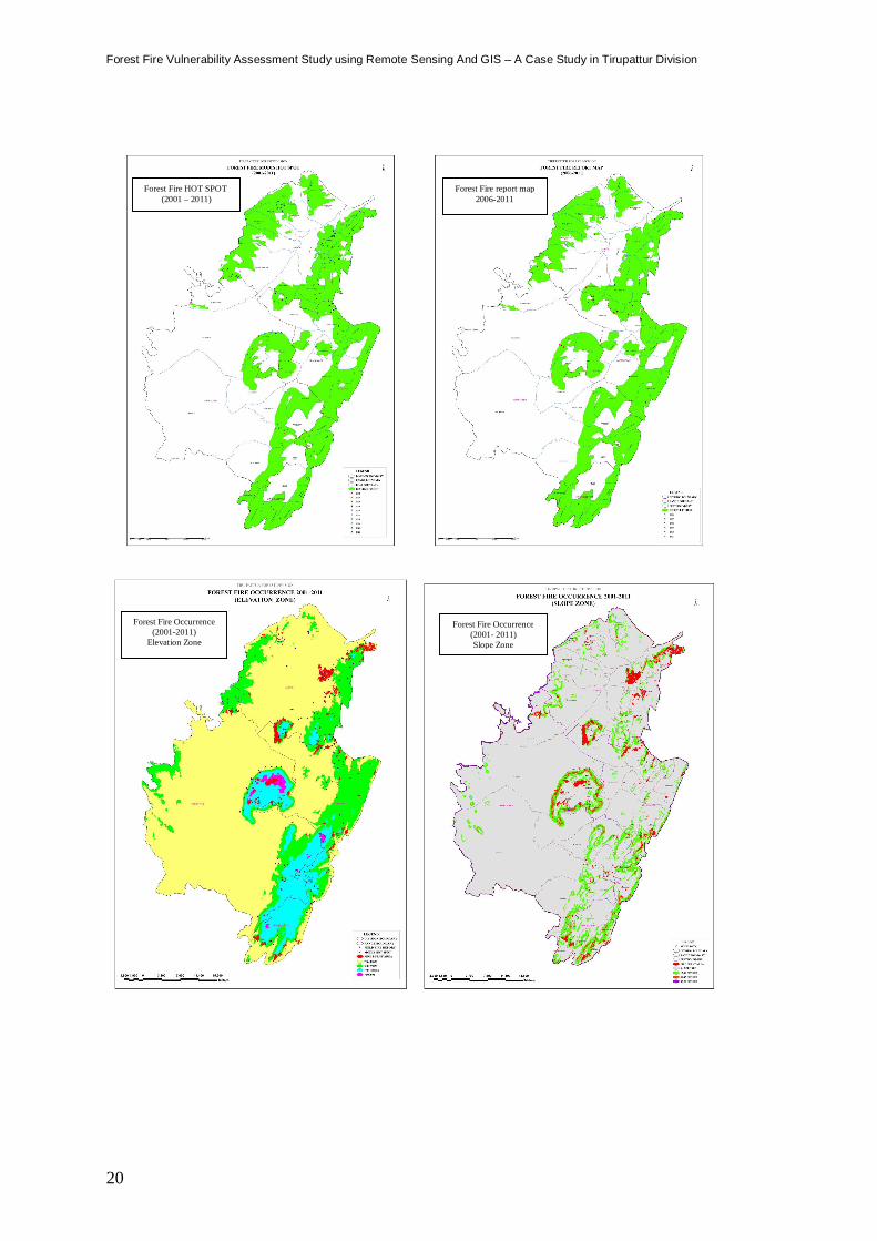
According to area burnt in each slope zone, the weightage for slope is given as in Table5.
Table 5: Slope weightage
Sl. No Slope Zone
(in Degree)
Burnt Area
(in Ha) Weightage
1 0 – 15 1945.09 4
2 15 – 30 1368.52 5
3 30 – 45 202.12 3
Forest Fire Vulnerability Assessment Study using Remote Sensing And GIS – A Case Study in Tirupattur Division
14
4 45 – 90 37.38 2
Aspect Risk:
Aspect is the direction in which slope faces. The 11 year Fire data and MODIS
data are over layed on Aspect and the intensity of fire was studied. According to fire
occurrence the weightage is given to each aspect is as in Table 6.
Table 6: Aspect weightage
Sl. No Aspect Burnt Area
(in Ha) Weightage
1 North 237.08 3
2 North Eastern 283.33 3
3 East 429.18 4
4 South East 681.93 5
5 South 428.141 4
6 South West 402.51 5
7 West 615.74 5
8 North West 469.21 4
Elevation Risk:
Elevation of an area above the sea level influences fire risk for the fact that fire
spreads quicker uphill than downhill. Availability of fuel like grasslands in higher
elevation also influences fire risk. The 11 year fire data and MODIS data are over layed
to assess the weightage for different elevation zones as in Table 7.
Table 7: Elevation weightage
Sl. No Elevation Zone (in Meters) Burnt Area Weightage
1 0-200 1498.12 4
2 200-500 1424.45 5
3 500-1000 344.909 3
4 > 1000 285.64 2
15
Forest Fire Vulnerability Assessment Study using Remote Sensing And GIS – A Case Study in Tirupattur Division
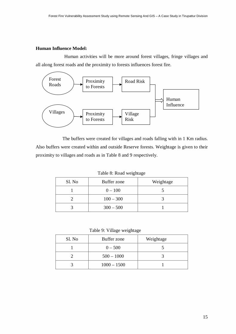
Human Influence Model:
Human activities will be more around forest villages, fringe villages and
all along forest roads and the proximity to forests influences forest fire.
The buffers were created for villages and roads falling with in 1 Km radius.
Also buffers were created within and outside Reserve forests. Weightage is given to their
proximity to villages and roads as in Table 8 and 9 respectively.
Table 8: Road weightage
Sl. No Buffer zone Weightage
1 0 – 100 5
2 100 – 300 3
3 300 – 500 1
Table 9: Village weightage
Sl. No Buffer zone Weightage
1 0 – 500 5
2 500 – 1000 3
3 1000 – 1500 1
Forest Roads
Proximity to Forests
Road Risk
Villages Proximity to Forests
Village Risk
Human Influence
Forest Fire Vulnerability Assessment Study using Remote Sensing And GIS – A Case Study in Tirupattur Division
16
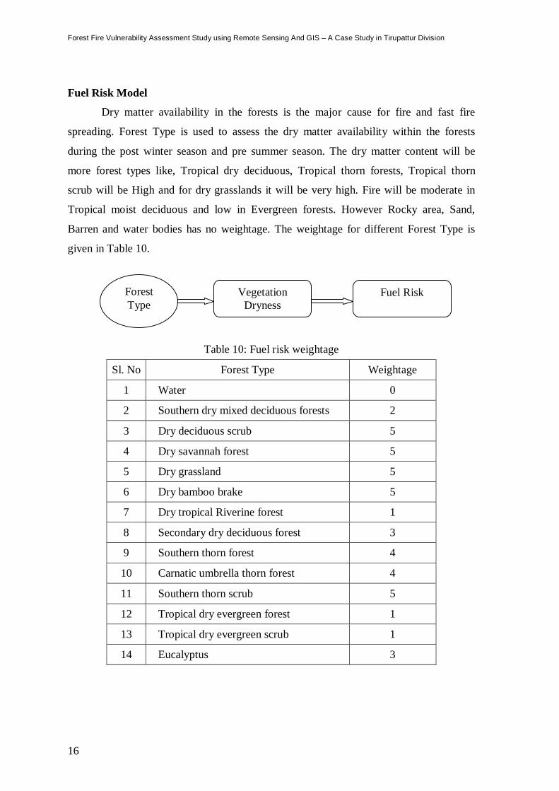
Fuel Risk Model
Dry matter availability in the forests is the major cause for fire and fast fire
spreading. Forest Type is used to assess the dry matter availability within the forests
during the post winter season and pre summer season. The dry matter content will be
more forest types like, Tropical dry deciduous, Tropical thorn forests, Tropical thorn
scrub will be High and for dry grasslands it will be very high. Fire will be moderate in
Tropical moist deciduous and low in Evergreen forests. However Rocky area, Sand,
Barren and water bodies has no weightage. The weightage for different Forest Type is
given in Table 10.
Table 10: Fuel risk weightage
Sl. No Forest Type Weightage
1 Water 0
2 Southern dry mixed deciduous forests 2
3 Dry deciduous scrub 5
4 Dry savannah forest 5
5 Dry grassland 5
6 Dry bamboo brake 5
7 Dry tropical Riverine forest 1
8 Secondary dry deciduous forest 3
9 Southern thorn forest 4
10 Carnatic umbrella thorn forest 4
11 Southern thorn scrub 5
12 Tropical dry evergreen forest 1
13 Tropical dry evergreen scrub 1
14 Eucalyptus 3
Forest Type
Vegetation Dryness
Fuel Risk
17
Forest Fire Vulnerability Assessment Study using Remote Sensing And GIS – A Case Study in Tirupattur Division
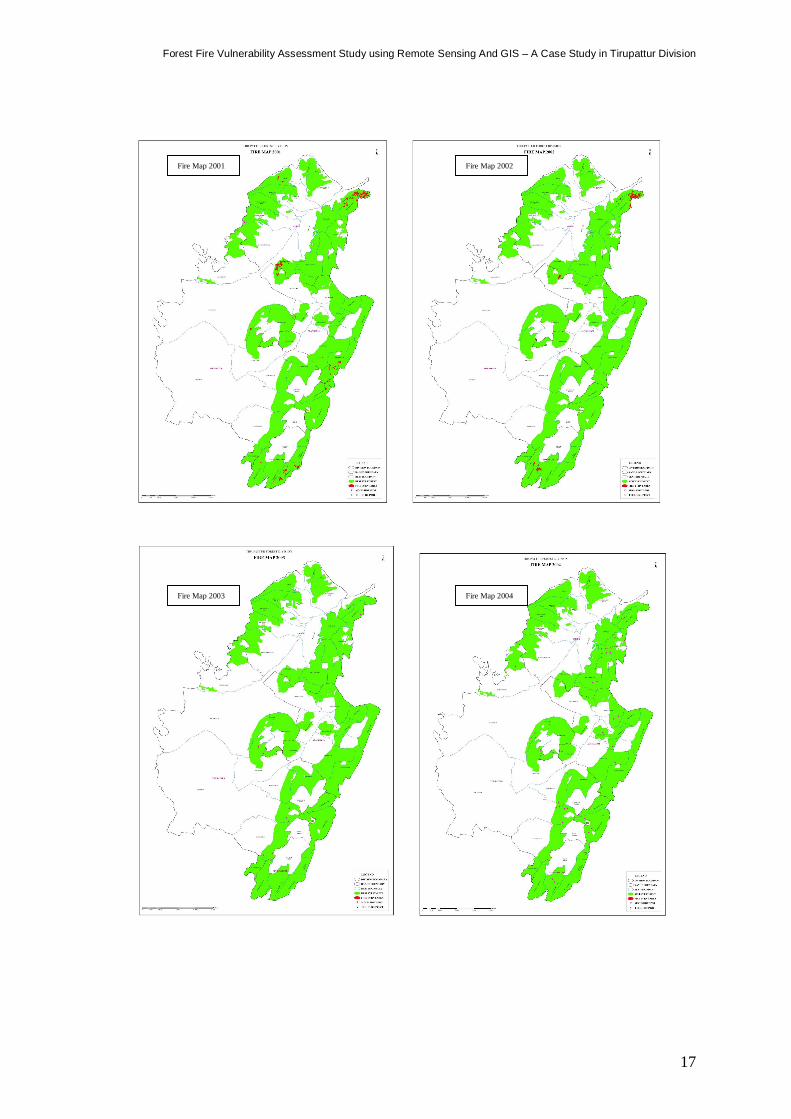
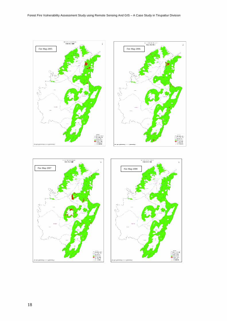
Fire Map 2001 Fire Map 2002
Fire Map 2004 Fire Map 2003
Forest Fire Vulnerability Assessment Study using Remote Sensing And GIS – A Case Study in Tirupattur Division
18
Fire Map 2005 Fire Map 2006
Fire Map 2007 Fire Map 2008
19
Forest Fire Vulnerability Assessment Study using Remote Sensing And GIS – A Case Study in Tirupattur Division
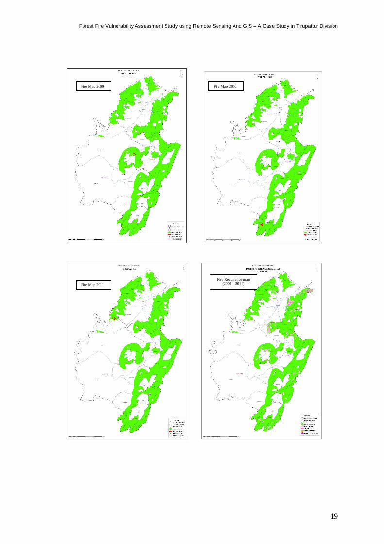
Fire Map 2009 Fire Map 2010
Fire Map 2011 Fire Recurrence map
(2001 – 2011)
Forest Fire Vulnerability Assessment Study using Remote Sensing And GIS – A Case Study in Tirupattur Division
20
Forest Fire HOT SPOT (2001 – 2011)
Forest Fire report map 2006-2011
Forest Fire Occurrence (2001-2011)
Elevation Zone
Forest Fire Occurrence (2001- 2011) Slope Zone
21
Forest Fire Vulnerability Assessment Study using Remote Sensing And GIS – A Case Study in Tirupattur Division
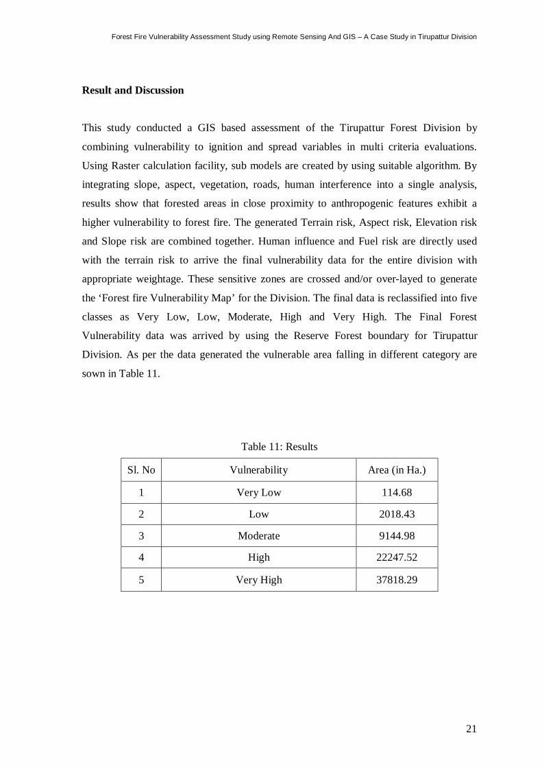
Result and Discussion
This study conducted a GIS based assessment of the Tirupattur Forest Division by
combining vulnerability to ignition and spread variables in multi criteria evaluations.
Using Raster calculation facility, sub models are created by using suitable algorithm. By
integrating slope, aspect, vegetation, roads, human interference into a single analysis,
results show that forested areas in close proximity to anthropogenic features exhibit a
higher vulnerability to forest fire. The generated Terrain risk, Aspect risk, Elevation risk
and Slope risk are combined together. Human influence and Fuel risk are directly used
with the terrain risk to arrive the final vulnerability data for the entire division with
appropriate weightage. These sensitive zones are crossed and/or over-layed to generate
the ‘Forest fire Vulnerability Map’ for the Division. The final data is reclassified into five
classes as Very Low, Low, Moderate, High and Very High. The Final Forest
Vulnerability data was arrived by using the Reserve Forest boundary for Tirupattur
Division. As per the data generated the vulnerable area falling in different category are
sown in Table 11.
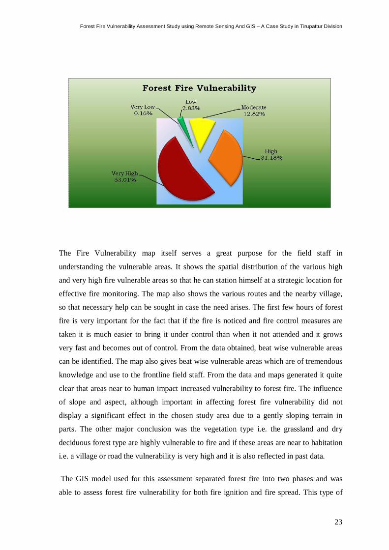
Table 11: Results
Sl. No Vulnerability Area (in Ha.)
1 Very Low 114.68
2 Low 2018.43
3 Moderate 9144.98
4 High 22247.52
5 Very High 37818.29

Forest Fire Vulnerability Assessment Study using Remote Sensing And GIS – A Case Study in Tirupattur Division
22
23
Forest Fire Vulnerability Assessment Study using Remote Sensing And GIS – A Case Study in Tirupattur Division
The Fire Vulnerability map itself serves a great purpose for the field staff in
understanding the vulnerable areas. It shows the spatial distribution of the various high
and very high fire vulnerable areas so that he can station himself at a strategic location for
effective fire monitoring. The map also shows the various routes and the nearby village,
so that necessary help can be sought in case the need arises. The first few hours of forest
fire is very important for the fact that if the fire is noticed and fire control measures are
taken it is much easier to bring it under control than when it not attended and it grows
very fast and becomes out of control. From the data obtained, beat wise vulnerable areas
can be identified. The map also gives beat wise vulnerable areas which are of tremendous
knowledge and use to the frontline field staff. From the data and maps generated it quite
clear that areas near to human impact increased vulnerability to forest fire. The influence
of slope and aspect, although important in affecting forest fire vulnerability did not
display a significant effect in the chosen study area due to a gently sloping terrain in
parts. The other major conclusion was the vegetation type i.e. the grassland and dry
deciduous forest type are highly vulnerable to fire and if these areas are near to habitation
i.e. a village or road the vulnerability is very high and it is also reflected in past data.
The GIS model used for this assessment separated forest fire into two phases and was
able to assess forest fire vulnerability for both fire ignition and fire spread. This type of
Forest Fire Vulnerability Assessment Study using Remote Sensing And GIS – A Case Study in Tirupattur Division
24
model allows for factors that influence fire in different ways to be incorporated in a way
that accurately reflects the way forest fire is influenced. This model was able to depict the
areas of high, medium and low risk areas and matches with the past history of fire
occurrences. The development of the high, medium and low vulnerability levels allows
for a complete understanding of potential in forest fire in Tirupattur Division. It also helps
in identification of suitable sites for positioning the fire watchers and construction of Fire
watch towers. Strengths of the GIS model include the ability to integrate multiple
variables into a single model, the potential for simple alteration to fit changing needs, and
the potential to apply this model in other areas where data access is adequate. Limitations
of this GIS approach include the absence of variables such as tree species and direct soil
moisture data, as well as the lack of accounting for temperature and precipitation data
which changes over short time periods. The results provide a greater understanding of
forest fire vulnerability and provide a base for forest fire prevention and management
policies.
25
Forest Fire Vulnerability Assessment Study using Remote Sensing And GIS – A Case Study in Tirupattur Division
References
1. Working plan for Tirupattur Forest Division
2. Tegan Buckingham, Daniel Felicetti and James Stephens, A GIS-Based MCE
Forest Fire Vulnerability Model for the City of Greater Sudbury, Ontario.
http://www.uoguelph.ca/geography/research/geog4480_w2011/Group07/index.sht
ml
3. http://forestfireindia.org/urls/fires_india.html
4. https://earthdata.nasa.gov/data/near-real-time-data/firms/active-fire-data
5. http://activefiremaps.fs.fed.us/gisdata.php
6. Morvan, D., Dupuy, J. L., Porterie, B., & Larini, M. Multiphase Formulation
Applied to the Modelling of Fire Spread Through A Forest Fuel Bed. Proceedings
of the Combustion Institute, 28, 2803-2809, 2000.
7. Sowmya, S. V., & Somashekar, R. K. . . Application of Remote Sensing and
geographical information system in mapping forest fire risk zone at Bhadra
wildlife sanctuary, India. Journal of Environmental Biology , 31 (6), 969-974,
2010
8. Gonzalez, J. R., Kolehmainen, O., & Pukkala, T. Using expert Knowledge to
Model Forest Stand Vulnerability to Fire. Computers and Electronics in
Agriculture , 107-114, 2007
9. Arienti, M. C., Cumming, S. G., & Boutin, S. Empirical models of forest fire
initial attack success probabilities: the effects of fuels, anthropogenic linear
features, fire weather, and management. Canadian Journal of Forest Research , 36,
3155-3166, 2006