For hydrocarbons. OPEN ROUND COLOMBIA 2010 URABA AREA January, 2010.
18
for hydrocarbons
-
Upload
ashley-nichols -
Category
Documents
-
view
214 -
download
2
Transcript of For hydrocarbons. OPEN ROUND COLOMBIA 2010 URABA AREA January, 2010.

for hydrocarbons

OPEN ROUND COLOMBIA 2010
URABA AREA
January, 2010

Total Hectares994.895
Seismic Lines WellsTotal Km Total206 3.874 5
Urabá Area
Urabá Blocks
Basin data
BLOCKS AREA (Ha)
URA 1 220693
URA 2 444198

Regional Tectonic Framework
1629-1X
Necocli-1
Apartado-1
Chigorodo-1

Apartado -1 Well Chigorodo -1 Well
AGENCIA NACIONAL DE HIDROCARBUROS
OverviewUrabá Basin

General Surface Geology
Faults and structural lineaments by accumulated number rose diagram
Uraba Basin suggested geologic column. Modified from Fllinch (in Bertolini et al, 2003) based on the description provided by ECOPETROL, 1982a.
Necoclí -1
Apartadó -1
Chigorodó-1

Reservoir RockReservoir Rock Source RockSource Rock Seal RockSeal Rock
Petroleum GeologyStratigraphic Columns
Apartadó-1 WellApartadó-1 WellChigorodó-1 WellChigorodó-1 Well

Wells and Seismic Lines Uraba Basin
Necoclí -1
Apartadó -1
Chigorodó -1
LEGEND
Wells___ Seismic line
Urabá-1
Turbo-1
1629-1X

Bouguer Anomaly Map
LEGEND
___ Contour Interval (20 mGal)

Seismic line 79-18
Representative Seismic Urabá Basin
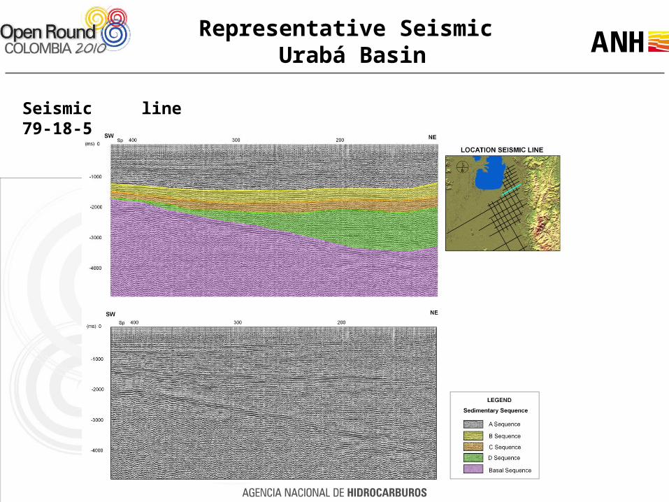
Seismic line 79-18-5
Representative Seismic Urabá Basin

Representative SeismicUrabá Basin
Seismic line 13-5

Seismic Structural Interpretation
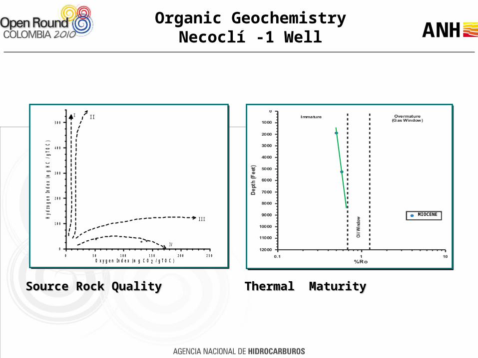
Organic GeochemistryNecoclí -1 Well
MIOCENE
0 50 100 150 200 250
Oxygen Index (m g CO2 / gTOC)
0
100
200
300
400
500
Hyd
rog
en In
dex
(m
g H
C /
gT
OC
)
I II
III
IV
Source Rock QualitySource Rock Quality Thermal MaturityThermal Maturity
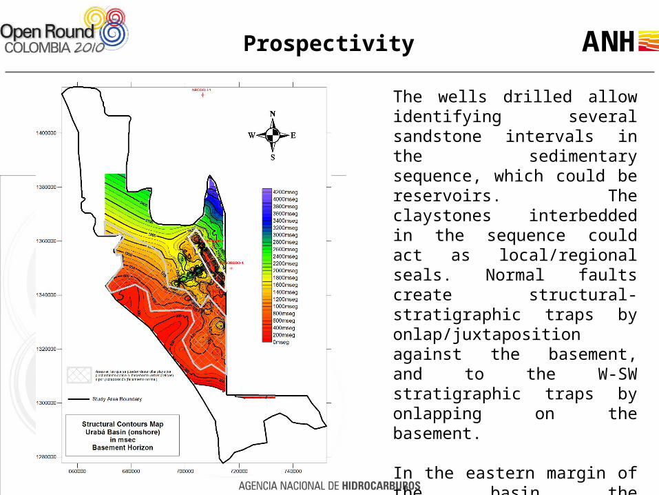
Prospectivity
The wells drilled allow identifying several sandstone intervals in the sedimentary sequence, which could be reservoirs. The claystones interbedded in the sequence could act as local/regional seals. Normal faults create structural-stratigraphic traps by onlap/juxtaposition against the basement, and to the W-SW stratigraphic traps by onlapping on the basement.
In the eastern margin of the basin the development of compressional folds close to the Uramita Fault are observed.

• The geochemical information (Necocli-1 well) is insufficient to corroborate or rule out the existence of proper conditions for hydrocarbons generation in the basin. It is also not possible to characterize any of the informal stratigraphic units as potential source rock.
• Regarding the reservoirs, the wells information shows the deposit of sandstones interbedded with claystones and siltstones along all the drilled sequence in the Apartado-1 and Chigorodo-1 wells. This implies that practically all the units in the basin could be potential reservoirs.
• Regarding the plays in the area, the seismic information indicates that the basin is tilted to the northeast and has flexural geometry. This flexure causes the development of normal faults that generate structural highs against which the sediments in the basin are truncated/onlapped, especially the deepest units (Units C and D). Due to the progressive basement’s shallowing towards the southwest; the more recent sediments overlap or pinch out against the basement in that direction creating potential stratigraphic traps.
Conclusions

Germán Vargas CuervoMsc - Ph. D.
Project Manager
Luis Castillo lópezMsc - Ph. D.
Roberto AguileraConsultant Geologist
Diana M. JiménezANH Supervisor
Universidad Nacional de ColombiaWork Team