
Flood Mitigation Plan - USDA · Flood Mitigation Plan Township of Franklin ... FEMA Flood Insurance...
183
New Jersey State-owned Muletenders Barracks, Griggstown on September 17, 1999 Flood Mitigation Plan Township of Franklin Somerset County, New Jersey February 2004 Prepared with assistance from USDA Natural Resources Conservation Service 220 Davidson Avenue, 4 th Floor Somerset, NJ 08873 732- 537-6040
Transcript of Flood Mitigation Plan - USDA · Flood Mitigation Plan Township of Franklin ... FEMA Flood Insurance...

New Jersey State-owned Muletenders Barracks, Griggstown on September 17, 1999
Flood Mitigation Plan
Township of Franklin Somerset County, New Jersey
February 2004
Prepared with assistance from USDA Natural Resources Conservation Service
220 Davidson Avenue, 4th Floor Somerset, NJ 08873
732- 537-6040


i
Table of Contents
List of Tables ................................................................................................................................................................... iv
List of Figures................................................................................................................................................................. iv
List of Photos................................................................................................................................................................... iv
List of Maps ..................................................................................................................................................................... iv
Acknowledgements ..........................................................................................................................................................v
Preface...............................................................................................................................................................................1
Section A - Community Organization .........................................................................................................................2
Section B - Public Involvement......................................................................................................................................2
Initial Public Meeting ...............................................................................................................................................2 Public Meeting on Draft Plan..................................................................................................................................2 Public Information Activities ...................................................................................................................................2 Questionnaires............................................................................................................................................................3 Solicitation of Comments..........................................................................................................................................3 Planning Process, Planning Committee Meetings...............................................................................................3
Section C - Coordination with Other Agencies .........................................................................................................3
Initial Contact with Agencies, Comments..............................................................................................................3 Meetings with Agencies.............................................................................................................................................4 Review of Community Needs, Goals, Plans for the Area .....................................................................................4 Agencies’ Comments on Draft Action Plan............................................................................................................6
Section D - Assessing the Hazard................................................................................................................................7
Background Information: Record of Past Floods...............................................................................................7 FEMA Flood Insurance Study............................................................................................................................. 9 Peak Discharges ................................................................................................................................................... 10
Flood Prone Areas...................................................................................................................................................12 Flood prone areas map ........................................................................................................................................ 12 Description of Other Natural Hazards............................................................................................................... 12

ii
Section E - Assessing the Problem............................................................................................................................12
Repetitive Flood Losses...........................................................................................................................................12 Affected Structures....................................................................................................................................................13 September 17, 1999 Flood Photos........................................................................................................................14 Description and Impact of Flooding.....................................................................................................................26 Critical Facilities in Plan Area.............................................................................................................................26 Impact of Flooding...................................................................................................................................................30 Existing Flood Protection Measures....................................................................................................................30
Section F – Set Goals ....................................................................................................................................................31
Section G - Review of Possible Activities ..................................................................................................................31
Community Rating System......................................................................................................................................31 Regulatory Activities: Existing Flood Plain Regulations and Recommendations for Change................32 Stormwater Management Regulations: Non-regulatory Activities and Nonstructural Management Practices.....................................................................................................................................................................32
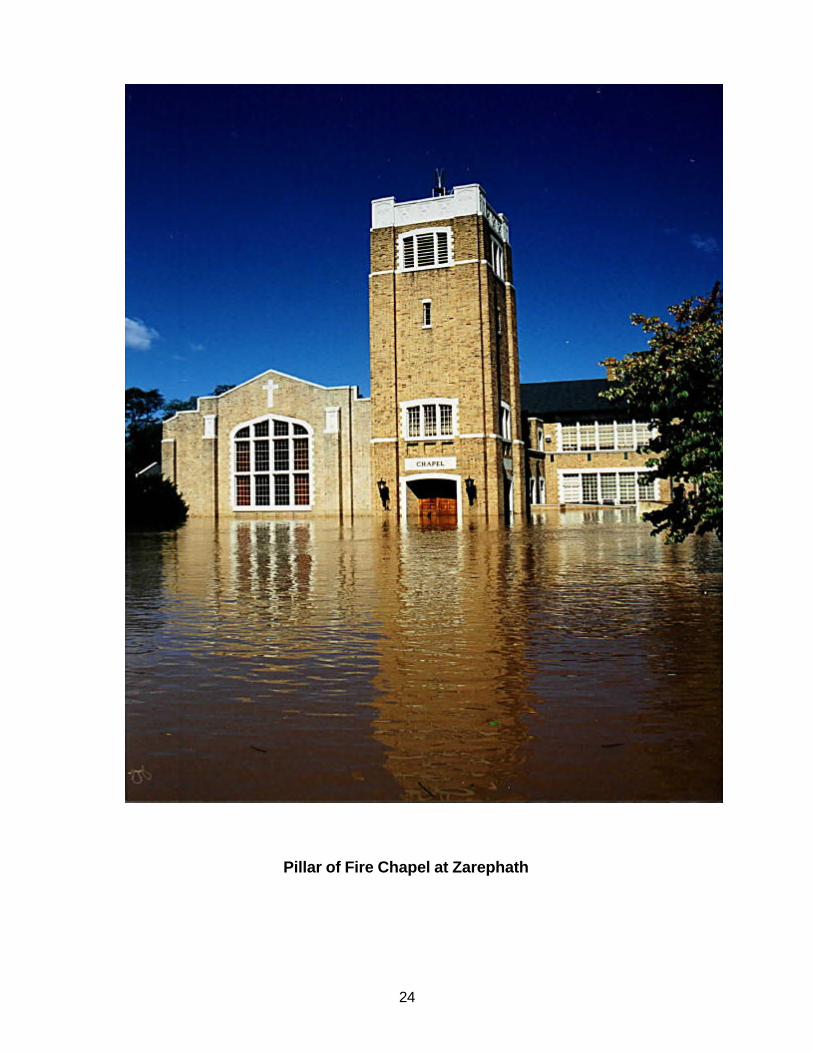
Buffer zones .......................................................................................................................................................... 33 Setbacks................................................................................................................................................................. 33 Minimum Natural Area ........................................................................................................................................ 33 Landscaping and Tree Protection...................................................................................................................... 33 Geo-notification (Reverse 911)........................................................................................................................... 34 Nonstructural Measures ..................................................................................................................................... 34 Purchase of Repetitive Loss Structures............................................................................................................ 34 Reconstruction of South Middlebush Road.................................................................................................... 35 Establis hment of Emergency Access to Route 287......................................................................................... 35 Pillar of Fire at Zarephath.................................................................................................................................... 35 State-Owned Historic Structures in the Flood Plain ....................................................................................... 35
Section H - Implementation of an Action Plan..........................................................................................................37
I. Evacuation Route Enhancement .......................................................................................................................37 1. Action Needed by Township ........................................................................................................................ 37
Posting of Flood Evacuation Route Signage .............................................................................................. 37 2. Action Needed by State and Somerset County.......................................................................................... 37
Traffic gates for Canal Road Vicinity Due to Closed River Crossings and Closed South Middlebush Road Stream Crossings................................................................................................................................... 37 3. Removal of Evacuation Route Deficiencies............................................................................................ 37
II. Public Participation .........................................................................................................................................38 1. Geo-notification............................................................................................................................................... 38 2. Public Information........................................................................................................................................... 38 3. Community Rating System............................................................................................................................. 38
III. Incorporation of Flood Mitigation Planning into Local Ordinances and Master Planning.............40 1. Revision of Flood Damage Prevention Ordinance..................................................................................... 40 2. Incorporation of Disaster Mitigation Planning in Master Plan................................................................ 40
IV. Public Property, Institutional and Critical Facility Flood Mitigation.................................................40 1. Critical Facilities............................................................................................................................................... 40

iii
2. Pillar of Fire at Zarephath............................................................................................................................... 40 3. State-Owned Historic Structures in the Flood Plain .................................................................................. 40
V. Private Property Flood Mitigation.................................................................................................................41 1. Property Owner Survey to Determine Interest in Flood Mitigation ........................................................ 41 2. Identification of Funding Sources ................................................................................................................ 41 3. Individual Property Structure Analysis ....................................................................................................... 41 4. Individual Property Flood Audits................................................................................................................. 41 5. Implement Flood Mitigation Measures........................................................................................................ 41 a. Elevation........................................................................................................................................................... 42 b. Floodproofing.................................................................................................................................................. 42 c. Relocation......................................................................................................................................................... 42 d. Acquisition and Demolition .......................................................................................................................... 42
Section I – Plan Adoption.............................................................................................................................................43
Section J - Plan Monitoring and Evaluation .............................................................................................................43
Bibliography...................................................................................................................................................................45
Appendix..........................................................................................................................................................................49
Resolution Appointing Franklin Township Flood Mitigation Planning Committee .................................51 Letter to Prospective Flood Mitigation Planning Committee Members........................................................55 Letter to Property Owners Regarding September 24th Public Hearing and Survey Questionnaire .........59 Property Owner Survey Questionnaire ................................................................................................................63 Letter to Neighboring Municipalities, State and County Agencies ...............................................................67 September 24, 2002 Public Hearing Minutes .....................................................................................................71 October 2, 2002 Flood Mitigation Planning Committee Minutes..................................................................77 October 22, 2002 Flood Mitigation Planning Committee Minutes ...............................................................83 November 13, 2002 Flood Mitigation Planning Committee Minutes............................................................89 December 11, 2002 Public Hearing......................................................................................................................95 February 27, 2003 Flood Mitigation Planning Committee Minutes .............................................................99 Agency Comments on Final Draft Flood Mitigation Plan ............................................................................ 103 Preliminary Damage Assessment Report for Hurricane Floyd Damages in Franklin Township........... 111 Structure Elevations and Flood Water Depths under Various Flood Events (Table 2) .......................... 121 Franklin Township Flood Damage Prevention Ordinance .......................................................................... 125 Suggested Changes to Existing Flood Damage Prevention Ordinance..................................................... 145 Copy of Resolution Approving Flood Mitigation Plan ................................................................................. 151 Federal Emergency Management Agency Flood Mitigation Plan Approval ............................................ 155

iv
List of Tables TABLE 1 – SUMMARY OF DISCHARGES....................................................................................................................... 11 TABLE 2 – FRANKLIN TOWNSHIP STRUCTURE ELEVATION AND FLOOD WATER DEPTHS UNDER VARIOUS
FLOOD EVENTS................................................................................................................................................... 121 TABLE 3 - FRANKLIN TOWNSHIP STRUCTURES WITH FIRST FLOOR FLOODING ALONG MILLSTONE RIVER26 TABLE 4 - FRANKLIN TOWNSHIP CRITICAL FACILITIES IN OR NEAR THE 100 YEAR FLOOD PLAIN.............. 27 TABLE 5 - FLOODING IMPACTS ON RIVER AND STREAM CROSSINGS.................................................................... 27 TABLE 6 - WATERSHED DEGRADATION BASED ON IMPERVIOUS COVER............................................................ 33 TABLE 7 – ACTION PLAN TIMETABLE ...................................................................................................................... 39
List of Figures FIGURE 1 PEAK STREAMGAGE HEIGHT BY YEAR FOR MILLSTONE RIVER AT BLACKWELLS MILLS YEARS
1921 THROUGH 2000............................................................................................................................................... 8 FIGURE 2 FRANKLIN TOWNSHIP CRITICAL HABITAT MAP................................................................................... 29
List of Photos (SEPTEMBER 17, 1999)
1076 CANAL ROAD, GRIGGSTOWN............................................................................................................................... 14 CANAL ROAD AND GRIGGSTOWN CAUSEWAY LOOKING AT 1079 CANAL ROAD, GRIGGSTOWN..................... 15 CANAL ROAD LOOKING NORTH FROM REFORMED CHURCH, GRIGGSTOWN....................................................... 16 D&R CANAL STATE PARK SUPERINTENDENT’S OFFICE ....................................................................................... 17 BRIDGETENDER’S HOUSE, BLACKWELLS MILLS AND CANAL ROADS.................................................................. 18 LOOKING WEST ACROSS CANAL ROAD TOWARD BLACKWELLS MILLS CANAL HOUSE.................................. 19 EAST MILLSTONE FIRST AID SQUAD BUILDING AND HISTORIC BRIDGETENDER’S HOUSE .......................... 19 FRANKLIN INN, EAST MILLSTONE.............................................................................................................................. 20 EAST MILLSTONE FIRST AID SQUAD BUILDING AND FRANKLIN INN ................................................................. 21 EAST MILLSTONE FIRST AID SQUAD BUILDING, FRANKLIN INN AND ONKA BUILDING................................. 22 EAST MILLSTONE BRIDGETENDER’S HOUSE ............................................................................................................ 23 PILLAR OF FIRE CHAPEL AT ZAREPHATH................................................................................................................ 24 VIEW OF MILLSTONE RIVER (BACKGROUND) AND PILLAR OF FIRE AT ZAREPHATH ...................................... 25
List of Maps DETAIL MAP INDEX WITH EVACUATION ROUTES AND STRUCTURE FLOOD VULNERABILITY DETAIL
MAPS.................................................................................................................................................................... 159 DETAIL MAP 1 ............................................................................................................................................................. 161 DETAIL MAP 2 ............................................................................................................................................................. 163 DETAIL MAP 3 ............................................................................................................................................................. 165 DETAIL MAP 4 ............................................................................................................................................................. 167 DETAIL MAP 5 ............................................................................................................................................................. 169 DETAIL MAP 6 ............................................................................................................................................................. 171 DETAIL MAP 7 ............................................................................................................................................................. 173 DETAIL MAP 8 ............................................................................................................................................................. 175

v
Acknowledgements I would like to acknowledge the excellent assistance of the Franklin Township Flood Mitigation Committee, including J. Gary Howarth, Township Emergency Management Coordinator; Theodore Chase, Township Planning Board and Environmental Commission member; Joe Russo, Township Engineer; Scott Thomas, Township Senior Engineer; Jeff Olszyk, Pillar of Fire Community at Zarephath; Susan Herron, D&R Canal State Park; Anton Lemli, affected property owner; Pat Bacon, East Millstone First Aid Squad; Jim Amon, D&R Canal Commission and Grants Coordinator Bonnie von Ohlen. Also, I would like to acknowledge the assistance of Tom Tiner of Civil Solutions, for his work on the maps. I would like to thank Tim Dunne, NRCS Wildlife Biologist, and Gary Casabona, GIS Specialist, for developing the Beneficial Functions Section. In addition, I would like to acknowledge the assistance of the members of the NRCS Watershed Planning Team: Carl DuPoldt, Planning Engineer; Kent Hardmeyer, Economist; Gary Casabona and ShayMaria Silvestri, GIS Specialist as well as my supervisor, Dr. David Smart, who provided reviews of the document as it was developed. Also, I would like to thank Barbara Phillips, NRCS Public Affairs Specialist, for her assistance in organizing the document and Linda Jump and Carol Yurkovic for their help in publication of the document. I would also like to thank a number of people who came forward to provide pictures of past flooding including Jeff Olszyk (Zarephath), Susan Herron (D&R Canal State Park Superintendent’s Office), Linda Barth (Griggstown muletenders barracks), Pat Bacon (East Millstone bridgetenders house, Franklin Inn and East Millstone First Aid Squad building), and Tom Kulik (Griggstown area buildings). Greg Westfall Water Resource Planner


1
Preface Setting The Township of Franklin is located in the southeastern part of Somerset County, adjacent to New Brunswick, in north-central New Jersey. It is bordered on the west by Princeton, Montgomery and Hillsborough Townships and Rocky Hill, Millstone and Manville Boroughs, on the north, Bridgewater Township and South Bound Brook Borough, on the northeast, Piscataway Township; on the east, New Brunswick City and North and South Brunswick Townships (See Location Map in Appendix). Historic and projected Township population is shown below: Year 1960 1970 1980 1990 2000 2020 Population 19,858 30,389 31,358 42,780 50,903 66,590 Source: US Bureau of Census (Actual Population) NJ Office of State Planning (Projected Population) Major routes include Interstate Route 287 in the northwestern portion of the Township, Route 514 (Amwell Road), Route 518, Route 527 (Easton Avenue), Route 27, Canal Road and South Middlebush Road. The Millstone River forms the western corporate limits of Franklin. Many of the streams in Franklin Township are tributaries to the Millstone River. Simonson Brook, Ten Mile Run and Six Mile Run are major tributaries flowing into the Millstone River. The Delaware and Raritan Canal in Franklin Township parallels the east bank of the Millstone River. Several of the smaller tributaries flowing west toward the Millstone River have been diverted into the Delaware and Raritan Canal. The topography of Franklin varies from approximately 320 feet above sea level in the southern part of the Township to approximately 10 feet along the Raritan River in the northeastern part of the Township. The Township consists of gently rolling hills with flat floodplains (up to 2000 feet wide), along the Millstone and Raritan Rivers. The average annual precipitation at New Brunswick is approximately 43 inches. The Township also lies within the Raritan River watershed and Millstone River watershed. Although this Plan limits its focus to the Millstone River watershed, many of the recommendations for flood mitigation measures are appropriate for the Raritan River watershed as well. There are several areas of the Township which lie in areas designated as flood plain. These areas are where repetitive flood losses have occurred. Repetitive flood losses is defined as those structures, which participate in the National Flood Insurance Program, which that have made damage claims under two or more flood events.

2
Section A - Community Organization Franklin Township received notification from the State Office of Emergency Management (OEM) that they had received a grant to develop this Flood Mitigation Plan on May 22, 2002. The Franklin Township Council approved a resolution to fund an agreement with the USDA Natural Resources Conservation Service on July 9, 2002. A Flood Mitigation Planning Committee was organized by the Franklin Township Council on September 9, 2002. A copy of the letter mailed to the prospective Committee members is in the Appendix. The following people agreed to accept their appointment to the committee:
Bonnie von Ohlen, Franklin Township Grants Coordinator Joseph Russo, Franklin Township Engineer Scott M. Thomas, Senior Engineer Gary Howarth- FT Office of Emergency Management Steven Androsko - Business owner - Canoe rentals - Police Department Theodore Chase – Environmental Commission/Planning Board James C. Amon - D & R Canal Commission Sue Herron - D & R Canal State Park Jeff Olszyk - Pillar of Fire
Other interested participants included Anton Lemli, property owner, and Pat Bacon, East Millstone First Aid Squad. This plan was prepared with the assistance of Gregory Westfall, Water Resource Planner, with the USDA Natural Resources Conservation Service.
Section B - Public Involvement
Initial Public Meeting
A public meeting was held on September 24, 2002 at the Franklin Township Municipal Building. The purpose of this meeting was to notify the local residents of the intention to prepare a Flood Mitigation Plan and to seek public input for flood problems and possible solutions. A copy of the public meeting minutes appears in the Appendix.
Public Meeting on Draft Plan
A second public meeting was held on December 11, 2002 at the Franklin Township Municipal Building. The purpose of this meeting was to discuss the draft Flood Mitigation Plan. Comments were received from the Township Committee and the public and were incorporated into the Plan.
Public Information Activities
Franklin Township distributed in their Township newsletter a notice of their intent to prepare the Flood Mitigation Plan and requesting the input of over 100 Township property owners. The Township notified the residents of the public meetings to discuss flooding and the preparation of the Flood Mitigation Plan.

3
Questionnaires
In addition, the Township distributed a questionnaire to all Township residents known to be in the Millstone River flood prone areas. A total of 100 surveys were mailed to property owners in or adjacent to the floodplain. A total of 23 responses were received. Period of property ownership ranged from approximately 2 years to 49 years. Eight of the respondents had had flood damages from Hurricane Floyd (1999). Two respondents had flood damages in Hurricane Doria (1971). Flood damages reported ranged from less than $100 to over $40,000. No solutions were proposed other than “stopping development upstream” in numerous cases. A copy of the questionnaire is in the Appendix.
Solicitation of Comments
Comments were solicited from the general public at the Initial Public Meeting on September 24, 2002 and at the Draft Plan Public Meeting on December 11, 2002.
Planning Process, Planning Committee Meetings
The Franklin Township Flood Mitigation Planning Committee met on October 2nd, October 22nd, November 13th and February 27th to develop and review the Flood Mitigation Plan. A copy of the minutes for each of these meetings is in the Appendix.
Section C - Coordination with Other Agencies
Initial Contact with Agencies, Comments
Prior to the start of planning, the Township was in contact with the State of New Jersey Office of Emergency Management and the New Jersey Department of Environmental Protection. At the start of the planning process, a letter (See Appendix) was sent to several municipalities and state and county agencies, notifying them of the Township’s intent to develop a flood mitigation plan. Contacted agencies were: FEMA Region II NJDEP, Flood Plain Management Section
Borough of Manville NJDEP, Historic Preservation Office
Borough of Millstone NJDEP, Division of Parks and Forestry
Borough of Rocky Hill Delaware and Raritan Canal Commission
Borough of South Bound Brook Township of Bridgewater
City of New Brunswick Township of Hillsborough
NJ Water Supply Authority Township of Montgomery
County of Somerset, Michael Amorosa, County Engineer Township of Piscataway
Somerset-Union Soil Conservation District Township of Princeton
NJ State Police, Division of Emergency Management Township of North Brunswick
Township of South Brunswick

4
Meetings with Agencies
Many municipalities and counties are participating as part of the Millstone River Watershed Steering Committee. This Committee formed in February 2000 as a result of resolutions of support from five counties including Hunterdon, Mercer, Middlesex, Monmouth and Somerset Counties and 12 of the 26 watershed municipalities including Franklin Township. The resolutions of support were approved for the development of a PL-566 (Watershed Protection and Flood Prevention) Plan. In June of 2000 the Committee identified seven goals and objectives for development of a watershed plan to address watershed concerns. Flood mitigation is the primary objective. Many other organizations and agencies participate in Steering Committee activities including the New Jersey Department of Environmental Protection, New Jersey Water Supply Authority, Federal Emergency Management Agency, Corps of Engineers and USDA Natural Resources Conservation Service. There were no comments from other agencies or the twelve neighboring municipalities at the beginning of the planning process. None of these groups attended either public hearing.
Review of Community Needs, Goals, Plans for the Area
There are several plans, done by both private and public entities, which could influence development and redevelopment in the flood plain in Franklin Township. The 1999 Master Plan identifies the following goals under the Land Use Plan Element: • Maintain the diversity of housing, but encourage in-fill and stabilization of current
residential areas rather than continuing sprawl patterns of development • Encourage commercial and industrial development in areas with access to
major regional highways (I-287) and in established areas • Differentiate between neighborhood commercial nodes and regional
commercial development • Maintain the character of the existing villages of Kingston, Griggstown, Franklin
Park, Middlebush and East Millstone • Encourage the continuation of farming as a viable land use • Support the redevelopment of declining areas within the Township • Create more effective design standards

5
The 1999 Master Plan identifies the following goal under the Conservation Plan Element: • Conserve open space, rural character, scenic vistas, sensitive environmental
areas and farmland The Master Plan also states:
Flooding in Franklin Township is limited to relatively narrow corridors along the rivers and streams (e.g. South Middlebush Road at Six Mile Run). Development applications for properties greater than 1 acre in area that drain into the D&R Canal are required to submit stormwater detention plans to the D&R Canal Commission, which reviews applications in terms of impacts on the Canal and neighboring towns. Franklin has implemented a Stream Corridor Preservation Ordinance that seeks to preserve stream corridors and floodplain through development regulations and dedications of easements, in addition to NJDEP regulations, so that storm events will be naturally attenuated. The Delaware and Raritan Canal State Park Development Plan (D&R Canal Commission, 2002) identifies the following actions which occur in or adjacent to the flood plain: • Restore and preserve the cluster of houses at Griggstown Causeway • Increase parking capacity at Griggstown and Blackwells Mills • Establish link to Six Mile Run Reservoir trails • Restore and use the East Millstone and Weston Canal houses • Establish a link to Colonial Park A review of the draft Delaware and Raritan Canal State Park Development Plan shows that restoration and preservation of the cluster of historic structures (Griggstown) at the intersection of the Griggstown Causeway and the D&R Canal is a priority. It is noted that these structures are flood prone but none of the listed tasks makes mention of the need to incorporate flood mitigation planning and implementation into the concept, construction and implementation plans. A need for data on the frequency of flooding is identified for the East Millstone house but no mention on the need to incorporate flood mitigation techniques into its restoration. The restoration and use of the East Millstone and Weston Canal houses should be done in a manner that recognizes their vulnerability to flooding. Every effort should be made to reduce the vulnerability of both their structure and contents within appropriate historic preservation and restoration. The use of the first floor of these structures should be avoided for the housing of any contents that could be lost during a flood.

6
The Pillar of Fire Zarephath East Long Range Plan (Deardorff, 2002). An update of its plan, in response to the Hurricane Floyd event of September 1999, is intended to provide a guide for both short and long term site development for the campus. An apparent decision has been made to site future development of the Pillar of Fire development to the east of Weston Canal Road. The Plan notes that the existing community is “in close proximity to the Canal and within the flood plain. Careful planning must be done not to increase the volume of buildings or fill within the flood plain.” Another concern is the extensive Pillar of Fire property in the Island Farm vicinity between the D&R Canal and Millstone River along the Weston Canal Causeway to Manville. This area is mapped by FEMA as either in the 100 year or 500 year flood zone. Current plans are to avoid either its development or its sale for development (Olszyk, 2003). The D&R Canal Area Redevelopment Study (Heyer, Gruel & Associates, 2003) is now being considered by Franklin Township. This study looks at three distinct areas along the D&R Canal. These areas include: • Stavola Study Area that consists two flood-prone structures at the intersection of
Canal and Georgetown Road • Laurie Rubber Study Area which consists of the former site of a rubber factory
located in the floodplain of the Canal • Onka Bus-Franklin Inn Study Area which consists of a working bus depot and
historic inn, which is currently rented as a used bookstore. The Study notes that the Stavola Study area location is adjacent to the Canal and within the Griggstown and Rocky Hill historic districts. The Study Area provides an important opportunity for historic reuse but, as a result of conditions such as steep slopes and flooding that inhibit development, their historic significance is not being properly utilized. Redevelopment opportunities at the other Study Areas are inhibited by site contamination, narrow streets and small lot sizes relative to the current zoning. The Study does not mention the potential for flood damages.
Agencies’ Comments on Draft Action Plan
Comments on the Final Draft Plan were received from Somerset County Engineering Division and the State Office of Emergency Management (See Appendix). Comments received from Somerset County were focused on the wording of action items for County action under the Evacuation Route Enhancement on the South Middlebush Road improvements and the installation of traffic gates and electronic warning sign as well as references to the redesign of the Griggstown Causeway. All County comments were addressed and revisions to the Plan made. Comments received from the State Office of Emergency Management referred to Public Involvement, Coordination with Other Agencies, Assessing the Hazards,

7
Assessing the Problem, Review of Possible Activities, Implementation of an Action Plan and Plan Adoption. Revisions to the Plan have been made to reflect the comments.
Section D - Assessing the Hazard
Background Information: Record of Past Floods
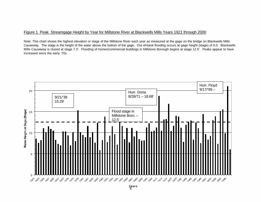
The Millstone River and several of its tributaries have had a long history of flooding. The worst floods recorded by Gurin (1962)on the Rocky Brook subwatershed at Hightstown were in (ranked from worst first): 1906, 1934, 1944, 1938-1915, 1923, 1955, 1882, 1960, 1962, 1948. Additional flooding in 1966 and 1967 were identified by Farlekas (1969). According to Bettendorf (1966) found few records of floods on the Stony Brook and the Millstone River immediately above Carnegie Lake. The greatest flood at Lake Carnegie at Princeton and at Millstone River near Kingston up to Bettendorf’s time occurred September 21, 1938 (Bettendorf, 1966). However, since that time successively greater floods occurred on August 28, 1971 (Hurricane Doria) and September 17, 1999 (Hurricane Floyd). Table 1 shows the peak streamflow at Blackwells Mills on the Millstone River.
8
Figure 1 Peak Streamgage Height by Year for Millstone River at Blackwells Mills Years 1921 through 2000 Note: This chart shows the highest elevation or stage of the Millstone River each year as measured at the gage on the bridge on Blackwells Mills Causeway. The stage is the height of the water above the bottom of the gage. Out-of-bank flooding occurs at gage height (stage) of 6.0. Blackwells Mills Causeway is closed at stage 7.3’. Flooding of homes/commercial buildings in Millstone Borough begins at stage 12.5’. Peaks appear to have increased since the early ‘70s.
0
5
10
15
20
Years
Hurr. Floyd 9/17/’99 – 21.01’ Hurr. Doria
8/28/71 – 18.68’ 9/21/’38 15.29’
Flood stage in Millstone Boro. – 12.5’
9
The lower Millstone River, from Kingston and Rocky Hill through Franklin, Montgomery and Hillsborough Townships including Millstone Borough, has had a long history of flooding. USGS hydrologic data indicate that major floods occurred in 1936, 1938, 1948, 1955, 1960, 1961,1971, January 1996, October 1996, September 1999. The three largest floods on the Millstone River prior to 1921, when the Blackwell Mills gage station records begin, were 1810, 1882 and 1896 (Ross, 1969). Historical accounts (1896 State Geologist Annual Report) show that the flood of 1882 was the largest known flood to have occurred prior to 1962 (Thomas, 1962). The storm of record occurred in 1999 (Hurricane Floyd) and was considered to range in terms of its frequency as follows: The Millstone River up at Carnegie Lake, the peak discharge from Floyd was about a 50-year flood and was 0.3 feet lower than Doria in 1971. The Millstone River at Blackwells Mills, the peak discharge from Floyd was about a 150-year flood and was 2.3 feet higher than Doria in 1971. The Millstone River at Manville, the peak discharge from Floyd was probably greater than a 150-year flood and was 3.6 feet higher than Doria in 1971. Flooding on the lower portion of the Millstone River can be greatly affected by flooding on the Raritan River. The peak stage on the Millstone River at Manville might have been even a 500-year flood. In this case the recurrence interval of the peak stage was probably greater than that of the peak flow. (Schopp, 2002). Flood depths around the Muletenders Barracks on Griggstown Causeway in excess of 12 feet (approximately second floor elevation) were recorded during the event. The previous storm of record occurred on August 28, 1971 (Hurricane Doria) when the USGS gage at Blackwell Mills was at 45.65 feet (gage height of 18.68 plus the elevation of the gaging station of 26.97 ft above sea level (1929 datum) which was more than 3 feet higher than the previous peak of record for the period from 1921 to 1970 (FEMA, 1989). The Township of Franklin, Somerset County, New Jersey, is located entirely in the Raritan River Basin. A Flood Insurance Study (FIS) for the Township was completed under the provisions of the National Flood Insurance Act of 1968. FEMA Flood Insurance Study The following information is abstracted from the March 16, 1989 FEMA Flood Insurance Study (FIS) report for Franklin Township: Principal Flood Problems The Millstone River has extensive, flat floodplains in Franklin. The towpath of the Delaware and Raritan Canal along the Millstone River somewhat limits flooding until the towpath is overtopped. The floodplain of the Raritan River, is narrower than that of the Millstone River, also borders the Delaware and Raritan Canal, which restricts flood flows until the towpath is overtopped (FEMA, 1989). The D&R Canal protective effect is only on the Franklin Township side of the Millstone and Raritan flood plains.
10
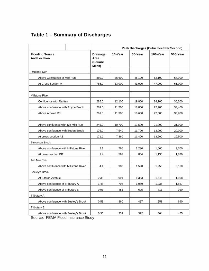
Peak Discharges The Flood Insurance Study includes Table 2 showing a summary of peak discharges for Millstone River watershed waterways in the Township. The 100 year discharge (21,200 cfs) for above Amwell Road can be roughly compared to the discharge at Blackwells Mills shown in Table 1. Note that the Hurricane Doria (August 29, 1971) discharge and Hurricane Floyd (September 17, 1999) discharge shown in Table 1 both nearly equal or exceed the 100 year frequency discharge shown in Table 2. The FIS provides a description of the community, principal flood problems and flood protection measures. The FIS report also describes prior studies and certain corrections to flood levels determined in such studies. FEMA has indicated that, for the purposes of this Flood Mitigation Plan, the NRCS HEC-2 model should be used (Duell, 2002). This model shows the 100 year (1%) flood elevation to be approximately one half foot higher than that shown in the FIS.
11
Table 1 – Summary of Discharges
Peak Discharges (Cubic Feet Per Second)
Flooding Source And Location
Drainage Area (Square Miles)
10-Year 50-Year 100-Year 500-Year
Raritan River
Above Confluence of Mile Run 880.0 36,600 45,100 52,100 67,000
At Cross Section M 785.0 33,000 41,000 47,000 61,000
Millstone River
Confluence with Raritan 285.0 12,100 19,800 24,100 36,200
Above confluence with Royce Brook 269.0 11,500 18,800 22,900 34,400
Above Amwell Rd.
261.0 11,300 18,600 22,500 33,900
Above confluence with Six Mile Run 245.0 10,700 17,500 21,200 31,900
Above confluence with Beden Brook 176.0 7,540 11,700 13,900 20,000
At cross section AS 171.0 7,360 11,400 13,600 19,500
Simonson Brook
Above confluence with Millstone River 2.1 766 1,280 1,660 2,700
At cross section BB 1.4 562 864 1,130 1,830
Ten Mile Run
Above confluence with Millstone River 4.4 980 1,590 1,950 3,160
Seeley’s Brook
At Easton Avenue 2.38 994 1,363 1,546 1,968
Above confluence of Tr ibutary A 1.48 795 1,089 1,235 1,567
Above confluence of Tributary B 0.93 451 625 713 910
Tributary A
Above confluence with Seeley’s Brook 0.58 360 487 551 690
Tributary B
Above confluence with Seeley’s Brook 0.35 239 322 364 455
Source: FEMA Flood Insurance Study

12
Flood Prone Areas
Flood prone areas map The flood plain in Franklin Township is delineated on a set of maps that accompany the Flood Insurance Study. In this Plan, structure vulnerability maps for key areas along the Millstone River flood zone are in the Appendix. These maps show the FIS study 100 year and 500 year flood zone boundary overlaid on Somerset County air photos. NRCS, with FEMA approval, has used an NRCS HEC-2 100 year flood elevation (approximately 0.5 foot higher than the FEMA Flood Insurance Study 100 year elevation) to determine the number and type of structures impacted. This value was considered by FEMA to be on the conservative side in that it includes more properties than likely would be the case with the FEMA elevation developed in the 1970s. While FEMA has recommended that the NRCS model results be used for analyzing the number and frequency of flooding of structures for this Plan, this does not necessarily mean that FEMA is revising the official FEMA map (Duell, 2002). The FEMA National Flood Insurance Program flood claims database (of those people who participate in the National Flood Insurance Program) shows only one repetitive loss structure in Franklin Township, local information indicates that numerous structures have received damages on more than one occasion. Based upon available information from the National Flood Insurance Program flood claims database and experience of members of the Planning Committee, the frequent flood loss areas include Blackwells Mills, Griggstown and Zarephath. Other areas that have experienced flood damages include East Millstone and Griggstown Lock/Little Valley vicinity. Description of Other Natural Hazards Erosion and other natural hazards do not appear to be a significant hazard in the impact areas. The primary hazards are associated with flooding resulting from hurricane-related rainfall or rainfall on snow and/or frozen ground.
Section E - Assessing the Problem
Repetitive Flood Losses
Repetitive flood losses are those where two or more National Flood Insurance Program claims have been made for the same property during the 1977-1999 period. By this strict definition, one structure in Griggstown has been identified as having repetitive losses. However, it is important to note that several properties, including some in Blackwells Mills, East Millstone, Griggstown and Zarephath, that have not been National Flood Insurance Program participants, have experienced flood damages on more than one occasion. For example one structure in Blackwells Mills experienced 18 inches and four feet of water on its first floor, respectively, due to Hurricane Doria and Floyd. Due to a property ownership change, this structure had flood insurance coverage only during Hurricane Floyd. Many structures are historic and owned by the State of New Jersey.

13
Affected Structures
The Natural Resources Conservation Service surveyed the first floor, low opening and adjacent ground elevations for over 90 structures in Franklin Township in 2001 and Weston Canal/Zarephath vicinity in late 2002. Fifty-four of these structures are residential or commercial structures with the remainder being garages and outbuildings. Table 3 in the Appendix shows the flood elevation above or below (shown as + or -) the first floor for 2, 10, 50, 100 and 500 year storm events based on the NRCS HEC-2 hydraulics modeling along the Millstone River main stem. The surveyed structures and their first floor vulnerability in these various flood events are shown on structure flood vulnerability detail maps in the Appendix. Properties other than those shown as having first floor vulnerability that are shown to be in the 100 year flood fringe may have basement flooding. The area between the River and the FEMA 100 year flood fringe is the Floodway where the most frequent flooding occurs. The pictures shown on the cover and the following pages were taken on September 17, 1999 showing flooding during the Hurricane Floyd event. Generally speaking, the flood levels shown are lower than the actual peak of the flood water which was reported to have occurred during the early morning hours of September 17, 1999. While the scope of this Plan is focusing on the Millstone River corridor, significant flood damage occurred to structures in the Raritan River corridor during the Hurricane Floyd event. Easton Avenue from Route 287 to Landing Lane Bridge was impassable from Landing Lane Bridge to JFK Boulevard and in the vicinity of McAteer’s Restaurant. All low-lying properties on the Canal side of Easton Avenue, including the Willow Creek Rehabilitation Center (formerly King James Nursing Home where 168 patients had to be evacuated), were flooded. Other affected structures that experienced loss of contents included the Rutgers Preparatory School and the commercial strip between the intersection of JFK Boulevard and the Rehabilitation Center (NJ Office of Emergency Management, 1999). Unlike the Millstone River corridor where NRCS has acquired structure elevation and hydraulic modeling data under another planning effort, there is no readily available data of this type for the Raritan portion of the Township.

14
September 17, 1999 Flood Photos
1076 Canal Road, Griggstown

15
Canal Road and Griggstown Causeway Looking at 1079 Canal Road, Griggstown

16
Canal Road Looking North from Reformed Church, Griggstown

17
D&R Canal State Park Superintendent’s Office

18
Bridgetender’s House, Blackwells Mills and Canal Roads

19
Looking West Across Canal Road Toward Blackwells Mills Canal House
East Millstone First Aid Squad Building and Historic Bridgetender’s House

20
Franklin Inn, East Millstone

21
East Millstone First Aid Squad Building and Franklin Inn

22
East Millstone First Aid Squad Building, Franklin Inn and Onka Building

23
East Millstone Bridgetender’s House
24
Pillar of Fire Chapel at Zarephath

25
View of Millstone River (background) and Pillar of Fire at Zarephath

26
Table 3 presents a summary of the number and types of property that are vulnerable to flooding in the Millstone River corridor as defined by the 500, 100, 50, 10 and 2 year flood events under the HEC-2 model. FEMA has indicated that, for the purposes of this Flood Mitigation Plan, the NRCS HEC-2 model should be used (Duell, 2002).
Table 3 - Franklin Township Structures with First Floor Flooding along Millstone River
Number of Structures Having First Floor Flooding Under Various Flood Events Type of Structure 500 Yr. 100 Yr. 50 Yr. 10 Yr. 2 Yr.
Institutional 11 0 Commercial 7 1 Residential 25 10 6 Outbuilding 13 4 2 Historic/State Park 2 2 2 1 Total 58 17 10 1 0 Note: Flood depths are based on the Natural Resources Conservation Service HEC-2 hydraulic modeling.
Description and Impact of Flooding
Franklin Township is estimated to have a 94 percent participation rate in the National Flood Insurance Program. The rate of participation was derived by dividing the number of policies in force by the number of residential and commercial structures reported as being located in the Special Flood Hazard Area (SFHA) of the municipality. As of June 17, 2002, Franklin Township had 85 flood insurance policies in force, representing $14,289,200 in coverage (Rizzo, 2002). Since 1978, there have been 33 paid losses totaling $672,733 with seven substantial damage claims since 1978 (Rizzo, 2002). The National Flood Insurance Program (NFIP) claims filed between 1977 and 1999 show that Franklin Township had the third highest dollars of flood damage claims filed in the 26 municipalities in the Millstone River watershed. Most of the claims were made for properties in the lower Millstone River valley. Only Manville and Millstone Boroughs had greater dollars claimed in the 1977-1999 period.
Critical Facilities in Plan Area
Critical facilities are those facilities that are essential for community functions. These include schools, nursing homes, fire stations, sewer and water treatment facilities, post office and other essential structures. Table 4 lists these structures.

27
Table 4 - Franklin Township Critical Facilities in or near the 100 Year Flood Plain
Type Number Example School/College 2 Pillar of Fire (Somerset Christian College) at Zarephath*
Rutgers Preparatory School Nursing Home 1 Willow Creek Rehabilitation Center First Aid Squad 1 East Millstone First Aid Squad U.S. Post Office 1 East Millstone Post Office Sewage Pumping Facility 1 Franklin Township MUA Pumping Facility at Griggstown Water Treatment Facility 2 North Brunswick Water Treatment Facility
Elizabethtown Water Company Facility * Facility protected by earthen levee from flood events up to and including the 100 year flood
In addition to flooded structures, other flood damages occur here. These include historic structure flooding, lost recreational user days in the D&R Canal State Park, lost employee time due to closed business and road and bridge flooding. Road and bridge flooding can cause major changes in emergency fire and ambulance routes, lengthen worker commutes and add further congestion to other already congested roads. During Hurricane Floyd flooding all Millstone River crossings at Manville Borough upstream to and including Route 27 at Kingston were closed. Those wishing to cross the River had to cross at Princeton. These closings included Route 610 (Wihousky Street) in Manville Borough, Route 514 (Amwell Road) at Millstone Borough, Blackwells Mills Road, Griggstown Road and Route 518 (Washington Street) at Rocky Hill. Several of these River crossings, particularly Griggstown and Blackwells Mills, are relatively frequently closed due to flooding. A summary of the vehicular use and approximate number of annual closings is show in Table 5.
Table 5 - Flooding Impacts on River and Stream Crossings Vehicle Trips Number of Road Closures
Name of River or Stream Crossing
Peak Hourly Weekday Morning Traffic
Peak Hourly Weekday Afternoon Traffic
Average Daily Weekday Traffic
1971-1996
1999 2000 22001 2200222003
Weston Canal Road 1314 1145 7635
Millstone (Route 514) Causeway 1051 1294 7958
Blackwells Mill Road 485 343 3133 59 3 1 3 1 8
Griggstown Causeway 514 430 2891 59 7 4 6 5 13
South Middlebush Road at Six Mile Run and Middlebush Creek crossings
16,162
Vehicle Trip Source: Somerset County Engineering Office Vehicle Trips – Weston Canal Road and Millstone (Route 514) Causeway, March 2001 Vehicle Trips – Blackwells Mills and Griggstown, January 2001 Road Closings data from Somerset County Flood Information System Road Closing data is unavailable for the South Middlebush Road crossings of Six Mile Run and Middlebush Creek which carry 16,162 vehicle trips on an average weekday

28
Beneficial Function Areas Franklin Township includes many areas with important ecological functions, valuable to the community. Natural areas include undeveloped areas classified as woodlands or wetlands. The 100-year flood plain of Franklin Township includes about 822 acres of wetlands, over 650 acres of which are deciduous wooded wetlands (NJDEP Wetland GIS Coverage). The natural vegetative climax community of most areas in the township, if left undisturbed by man, would be a mature mixed hardwood forest that includes oak, hickory, tulip poplar, maple and other trees and a diverse array of shrubs and herbaceous vegetation on the forest floor. The species composition of the forest differs based upon soil moisture and landscape position. Forested areas and wetlands in watersheds improve water quality by intercepting rain water and reducing runoff, storing floodwaters for slower natural release, storing and cycling nutrients, removing potential pollutants in runoff, providing shade and more stable temperatures to aquatic systems and increasing the biological diversity and organic food base of waters downstream. Another significant beneficial natural resource in the township is the agricultural land. Agricultural areas, although generally not as ecologically valuable as forests and wetlands, can provide important ecological functions. Agricultural landscapes are aesthetic, can provide unique wildlife habitats and usually have reduced runoff when compared to developed areas. Figure 2 displays Critical Habitat information for Franklin Township. The source of the information is the NJ DEP “Landscape Project” (NJDEP, Division Fish & Wildlife, ENSP Landscape Project Database). The Landscape Project data combines rare species location information with land use/land cover classification data to produce accurate, reliable maps for habitat protection. While not all beneficial ecological functions are reflected in these habitat maps, the majority of the important ecological functions would occur in the areas depicted. Some smaller, less important wildlife habitats may be present in the township and not portrayed on this map. Landscape Project Data indicate over 4000 acres of critical grassland habitat in the township, primarily on farmlands in the central portion of the township and along the Millstone River. Over 900 acres of critical forest habitat is found primarily in the southern tip of the township. Over 600 acres of critical forested wetland habitat is scattered throughout the township, often associated with streams such as Six Mile Run and Simonsen Brook. About 200 acres of critical emergent wetland habitat is similarly scattered throughout the township, along streams. Most of the critical wildlife habitat defined by the Landscape Project database falls on lands outside of flood plains in the township. Only 691 acres (or about 17%) of this critical habitat falls on lands within the 100-year flood plain. Of that total, 316 acres are critical grassland wildlife habitat and 232 acres are critical forested wetland wildlife habitat. Only 83 acres of critical forested wildlife habitat and 60 acres of critical emergent wetland wildlife habitat are found within the 100-year flood plain in the township.

29
Figure 2 Franklin Township Critical Habitat Map

30
Impact of Flooding
The economic impact of flooding in Franklin Township has not been assessed previously. Recently, the USDA Natural Resources Conservation Service has analyzed flood damages with the period of record including the Hurricane Floyd flood event. Based on this assessment, average annual flood damages to structures and their contents, due to flood events up to and including the 100 year (1%) flood event amount to $56,948. In addition, damages due to closed river crossings amount to an estimated cost of $230,000 per day of road closure or estimated cost of $1 million per year for all four crossings. This does not include the impact of closure of South Middlebush Road at the Middlebush Creek and Six Mile Run crossings. According to Somerset County, there is a two way weekday volume of 16,162 vehicles on South Middlebush Road just north of Buffa Drive. An economic assessment of Hurricane Floyd damages was done for New Jersey with specific references to nearby Manville and Bound Brook (EDA/FEMA, 2000). However, a summary of the Preliminary Damage Assessment Report describing flood damages following Hurricane Floyd flooding is shown in the Appendix. No dollar estimates were available.
Existing Flood Protection Measures
The U.S. Army Corps of Engineers in August 1982 completed a Survey Report for Flood Control that, in part, covered the lower part of the Millstone River watershed. Levee enhancement was proposed to protect Zarephath (Alma White College) in Franklin Township. The report noted that at that time, following hydrologic, hydraulic and economic analyses, the proposed levee enhancement could not be economically justified. A flood levee was constructed (circa 1950)on the floodplain of the Millstone River to protect the Alma White (now Pillar of Fire) College buildings and grounds in Zarephath. FEMA specifies that all levees must have a minimum of 3 foot freeboard against 100-year flooding to be considered a safe flood protection structure. The top of the levee is at an approximate elevation of 39 feet. The levee was overtopped by the flood of August 28, 1971 (Hurricane Doria), approximately equal to the 100-year event. Recently Pillar of Fire at Zarephath has received approval from FEMA for a Letter of Map Amendment (LOMA) to amend the official floodway map. The purpose of the map amendment will be to re-define the official floodway so as to permit rehabilitation of an existing structure as well as make repairs to the existing levee which was damaged by the September 16 - 17, 1999 Hurricane Floyd flood. The State of New Jersey, as part of its Green Acres Project, has purchased land that makes up part of the Millstone River floodplain. In addition, the state has purchased approximately 3000 acres of land, which covers most of the floodplain along Six Mile Run and several of its tributaries, for a multipurpose reservoir. State regulations to control the use and development of the floodway of the Millstone and Raritan Rivers were enacted on June 2, 1975. The state regulations put severe restrictions on any activity in the designated floodway (FEMA, 1989).

31
Somerset County has established Spooky Brook Park, which almost entirely surrounds Spooky Brook, a small tributary to the Millstone River. Franklin Township has no specific flood warning devices. However, Somerset County Communications has the ability to receive flood information by warning devices located at East Millstone, Blackwells Mills and Griggstown. These locations are subject to flooding and can impact on communities within the Township. Information affecting these areas is referred to the Police Dispatchers, who notify the Emergency Management Coordinator. At present there is a computerized (Dialogic) telephone alert system (Howarth, 2002). Road crossings at Blackwells Mills and Griggstown have manual road closure gates for when flooding occurs in these areas.
Section F – Set Goals The goals of the Flood Mitigation Plan are to:
1. Protect human life and health 2. Identify and mitigate flood hazards 3. Reduce flood losses to existing buildings and contents 4. Prevent increases in flood damage from new construction 5. Reduce the risk of erosion damage 6. Protect natural and beneficial floodplain functions 7. Facilitate accurate insurance ratings 8. Promote the awareness of flood insurance
Section G - Review of Possible Activities
Community Rating System
Since 1968 the National Flood Insurance Program (NFIP) has provided federally backed flood insurance to encourage communities to enact and enforce flood plain regulations (FIA, 1990). The program has been very successful in helping flood victims get back on their feet. In order to be covered by a flood insurance policy, a property must be in a community that participates in the NFIP. To qualify, a community adopts and enforces a flood plain management ordinance (See Appendix) to regulate proposed development in flood hazard areas. The objective of the ordinance is to ensure that such development will not aggravate existing flooding condition and that new buildings will be protected from future flood damage. Since the early 1990s the Federal Insurance Administration has implemented the Community Rating System (CRS). The purpose of CRS is to recognize or encourage community activities to reduce flood damages to existing buildings, to manage development in areas not mapped by the NFIP, to protect new buildings beyond the minimum NFIP protection level, to help insurance agents obtain flood data, or to help people obtain flood insurance. Community application for CRS classification is voluntary.
32
Any community in full compliance with the rules and regulations of the NFIP may apply for a CRS classification. The applicant community submits documentation that it is implementing one or more of the activities recognized in the CRS Schedule. The Schedule identifies 18 creditable activities organized under four categories that include Public Information, Mapping and Regulations, Flood Damage Reduction, and Flood Preparedness. As a result of participation in the CRS activities, communities receive benefits including reduced flood insurance rates, increased public safety, reduction of damages to property and public infrastructure, avoidance of economic disruption and losses, reduction of human suffering, and protection of the environment. Public information activities which receive credit under CRS include elevation certificate, map determinations, outreach projects, hazard disclosure, flood protection library and flood protection assistance. Mapping and regulatory activities include additional flood data, open space preservation, higher regulatory standards, flood data maintenance, and stormwater management. Flood damage reduction activities include repetitive loss projects, acquisition and relocation, retrofitting, and drainage system maintenance. Flood preparedness activities include flood warning program, levee safety and dam safety.
Regulatory Activities: Existing Flood Plain Regulations and Recommendations for Change
Applications for development adjacent to the Canal must be submitted to and receive a favorable approval from the Delaware & Raritan Canal Commission. Also, no new structure may be located within 100 feet of the Canal, and all new structures and alterations within 1,000 feet of the Canal are subject to review by the Franklin Township Historic Preservation Commission. Significant portions of this area are in the Franklin Township Rural Residential (RR-5) and Canal Preservation (CP) zones. Both of these zoning classifications are intended to preserve the rural character of the least developed parts of the Township, with the RR-5 zone requiring minimum 5 acre lots and the CP zone requiring minimum 6 acre lots. The 1978 Flood Hazard Area Control Act requires strict environmental constraints regarding site discharges, ground disturbance, and loss of flood plain storage through the NJDEP’s Stream Encroachment Permit process. Franklin Township currently has a Flood Damage Prevention ordinance adopted on May 22, 1980 (See Appendix). The Township Engineer is responsible for implementation of this ordinance. A review of the existing Flood Damage Prevention ordinance and recommendations for change were made by DEP (Gilman, 2002) and are listed in the Appendix.
Stormwater Management Regulations: Non-regulatory Activities and Nonstructural Management Practices
While much of the flooding in Franklin Township results from stormwater runoff from municipalities far upstream of the Township on the River, significant areas of the Township can experience flooding along major tributaries to the Millstone River. These

33
tributaries include Six Mile Run, Ten Mile Run and Simonson Brook. While significant portions of the Six Mile Run and Ten Mile Run watersheds originate in relatively more developed North Brunswick and South Brunswick Townships, respectively; a significant portion of the contributing drainage area or watershed to these and other tributaries to the Millstone River occur within the Township. Imperviousness is the sum of roads, parking lots, sidewalks, rooftops, and other impermeable surfaces of the urban landscape. Impervious cover affects the hydrology, habitat structure, water quality and biodiversity of aquatic systems (Schueler, 1995). A watershed is the land area that drains into a particular stream, river or other water body. Schueler (1994) has classified urban watersheds into three categories based on their impervious cover. These categories are shown in the Table 6.
Table 6 - Watershed Degradation Based on Impervious Cover Stream Classification Percent of Watershed with
Impervious Cover Stressed 1 – 10 Impacted 11 – 25 Degraded 25 – 100
Many of the varied nonstructural management practices and source controls available are good examples of common sense and a stewardship ethic (Horner, et al., 1994). Many of the same principles used for planning for clean water will result in reduced runoff and downstream flooding (NJDEP, 1999). Buffer zones Land development codes often establish a minimum distance that the zone must extend from a sensitive feature, depending on a variety of site specific characteristics. Setbacks Discrete distances are established by state or local regulations and used to protect sensitive areas and meet environmental goals. Both setbacks and buffer zones can be protected through a variety of legal mechanisms including purchase, easements, or conservation easements. Minimum Natural Area Some local codes specify a minimum portion (e.g. 20 percent) to be maintained in its natural condition, unless the site is already degraded, to preserve critical features and reduce overall development impacts. Landscaping and Tree Protection Local codes often specify landscaping requirements (e.g. plant types and sizes) and protect certain trees, based on diameter and species, to reduce clearing. This protection reduces erosion, sediment and runoff problems. Minimizing impervious areas is the most effective way to preserve a site’s predevelopment runoff characteristics. Local codes may specify the maximum proportion of impervious cover allowed. Techniques include:

34
Reducing building setbacks, which reduces the lengths of driveways and entry walks. This technique is most applicable along low-use roads where traffic noise is not a problem. Geo-notification (Reverse 911) The purpose of this measure would be to personalize flood warning. Currently the Somerset County Flood Information and Warning System notifies municipal leaders of an impending flood. Geo-notification of individual structure owners and occupants can be accomplished using elevation data for each structure and known elevations of various storm events such as the 2, 10, 50, 100 and 500 year events. The System needs to be extended to the individual structure owners or occupant to be complete. In 2001 and 2002 NRCS completed an engineering survey of approximately 65 structures in the Millstone River flood zone in Franklin Township. Information shown in Table3 , in addition to a digital photo of the structure, is recommended for linkage to a geographic analysis system. Nonstructural Measures Nonstructural measures (as opposed to structural flood mitigation measures such as dams and levees) include those changes made to individual structures to minimize or eliminate flood loss. Nonstructural measures include elevating, relocating, removing or flood proofing a structure. Purchase of Repetitive Loss Structures One repetitive loss structure, with two or more claims under the National Flood Insurance Program (NFIP), has been identified by the Federal Emergency Management Agency in the Griggstown vicinity. There are many other structures that, while not covered by the NFIP, have suffered two or more incidents of flooding. Some of these structures were insured by the NFIP during the Hurricane Floyd flood. Others are still not insured by NFIP but rather under a State government self-insurance program that renders them ineligible for flood mitigation measures under this Plan.

35
Reconstruction of South Middlebush Road South Middlebush Road is an important north-south artery in the Township prone to flooding at Six Mile Run and Middlebush Creek. According to Somerset County (Andreassen, 2002) traffic surveys by the Township have been completed on several occasions during the last ten years. While there are no immediate County plans for major reconstruction and/or realignment of Middlebush Road, it is recommended that the road be raised above the 100 year flood elevation at the two above-named stream crossings and their approaches. An alternative measure may be to relocate South Middlebush Road outside the proposed boundary of the proposed Six Mile Run reservoir impoundment wherever there have been previous problems with flooding across it. Establishment of Emergency Access to Route 287 Franklin Township is working with neighboring municipalities, particularly South Bound Brook, to establish an emergency access entrance to Route 287 from Elizabeth Avenue. Elizabeth Avenue provides the only flood evacuation route for South Bound Brook. Pillar of Fire at Zarephath The Zarephath West Campus of Pillar of Fire represents a relatively unique situation as it relates to flood vulnerability in the Township. Currently there are numerous buildings which are located in the traditional flood plain of the Millstone River protected up to and including the 100 year flood event by an earthen levee built in about 1950. According to its recently approved Master Plan (Deardorff, 2002), the “overarching strategy of the Master Plan is to move expanding Pillar of Fire Ministries out of the flood plain to the south of Weston Canal Road. “ The Plan further states “the great benefit of this action will be to free up space to expand the ZBI Ministry without violating flood plain restrictions by adding more building volumes in the flood plain.” State-Owned Historic Structures in the Flood Plain A concern raised on several occasions by the Flood Mitigation Planning Committee has been the number of State-owned historic structures associated with the D&R Canal State Park which are flood vulnerable. At least two state officials had been invited to sit on the Township Flood Mitigation Planning Committee. Representation by the State at the three Flood Mitigation Planning Committee meetings was limited to one meeting where the Committee was informed by Sue Herron, State Park Superintendent that the State does not cover these structures under the National Flood Insurance Program but has a self-insurance policy for flooding. It was the Committee’s understanding that considerable funding has been spent and/or will be spent in the rehabilitation of many of these structures based on a plan developed by the Parks and Forestry.

36
Several inquiries to the State Parks and Forestry in Trenton for further information have produced little feedback, however, a response was received from Jim Amon of the D&R Canal Commission that: “The State has produced a sort of master plan for the Griggstown area but no details have been added to it. To the best of my knowledge the answer to all of your questions is that we have not progressed to the point where we have answers yet. “ Inquiries to the State Parks and Forestry in Trenton included the following unanswered questions: 1. Will flood mitigation strategies and technology be used in any rehabilitation of these structures? 2. Does the State anticipate obtaining its flood insurance through the National Flood Insurance Program so as to make itself eligible for project funding to avoid or reduce future flood losses?

37
Section H - Implementation of an Action Plan The Franklin Township Flood Mitigation Planning Committee recommends that Franklin Township and other entities, including State and County government, shall implement the activities as shown in the Table 7. Recommendations are prioritized by the number shown for the five major categories and actions are prioritized within each section. Funding will be sought from a variety of sources including FEMA Flood Mitigation Planning Project Grants (75 percent FEMA, 25 percent local funding) resulting from this Plan development.
I. Evacuation Route Enhancement
1. Action Needed by Township
Posting of Flood Evacuation Route Signage
The Township should formally post signage along the recommended flood evacuation routes as per the official flood evacuation route map in this Plan and the Emergency Operations Plan. 2. Action Needed by State and Somerset County
Traffic gates for Canal Road Vicinity Due to Closed River Crossings and Closed South Middlebush Road Stream Crossings
Franklin Township endorses the County investigating the feasibility of installing traffic gates and electronic warning signs in the Canal Road vicinity, so as to avoid the potential for loss of life and property as a result of motorist traffic. Motorists rerouted from the currently deficient flood evacuation route along South Middlebush Road and motorists attempting to cross at the River (at Blackwells Mills and Griggstown) could be deflected from entering the vicinity by electronic warning signs. These signs could be placed at the intersections of Jacques and South Middlebush Roads, Canal Road and Route 514, Blackwells Mills and South Middlebush Roads, Suydam and South Middlebush Roads and other critical intersections.
3. Removal of Evacuation Route Deficiencies
The State is working in finding acceptable access to Route 287 from Elizabeth Avenue to permit evacuation of residents from South Bound Brook Borough and Franklin Township. Franklin Township endorses Somerset County investigating the feasibility for providing acceptable access along the entire length of South Middlebush Road including its crossings of Middlebush Creek and Six Mile Run. The D&R Canal State Park Draft Development Plan recommends the closing the existing Griggstown causeway as “the long-term key to saving the historic character of this area…and work with Somerset County to seek an alternative crossing so that this one can be closed.” The Franklin Township Flood Mitigation Committee endorses the concept

38
of closing the existing Griggstown causeway if and when an alternative all-weather crossing is constructed. The Committee recommends that this be done only when appropriate traffic and other studies are completed.
II. Public Participation
1. Geo-notification The Township should refine their program to incorporate flood prone properties including Block and Lot, street address, digital photo, first floor and low opening elevations and other identifier information. The Somerset County Flood Information data will be used by the Township to provide flood warning information to individual property owner/occupants. The Township GIS Office will work with the Township Office of Emergency Management and Police Department to implement this system. 2. Public Information The Township should implement a program to inform their residents to the threats of flooding and the benefits of flood insurance and direct them to the appropriate sources for assistance in this matter. This will involve working with the area insurance agents to assure their input. The Office of Emergency Management and the Township Public Information Officer will perform this over the next 6 months. 3. Community Rating System The Township, working through the Flood Mitigation Committee in an ongoing manner, should implement measures to address one or more of the 18 activities in the Community Rating System to reduce or minimize property owner flood insurance premiums.

39
Table 7 – Action Plan Timetable
Activity 2004 2005 2006 2007 2008 Evacuation Route Enhancement
Posting of Flood Evacuation Route Signage
X
Traffic Gates and Electronic Warning Signage
X
Removal of Evacuation Route Deficiencies
X
Public Participation
Geo-notification X X X X X
Public Information X X X X X
Community Rating System X X
Incorporation of Flood Mitigation Planning into Local Ordinances And Master Planning
Revision of Flood Damage Prevention Ordinance
X
Incorporation of Disaster Mitigation Planning in Master Plan
X
Public Property, Institutional and Critical Facility Flood Mitigation
Critical Facilities X
Pillar of Fire at Zarephath X
State-Owned Historic Structures in the Flood Plain
X X X X
Private Property Flood Mitigation
Property Owner Survey X
Identification of Funding Sources X X X X
Individual Property Structure Analysis
X
Individual Property Flood Audits X
Implement Flood Mitigation Measures X

40
III. Incorporation of Flood Mitigation Planning into Local Ordinances and Master Planning
1. Revision of Flood Damage Prevention Ordinance The Township should revise its existing Flood Damage Prevention Ordinance to incorporate the suggested recommendations from the State Flood Plain Management Program. 2. Incorporation of Disaster Mitigation Planning in Master Plan The Township should include disaster mitigation planning as an element in its Master Plan. The Flood Mitigation Plan should be incorporated by reference into the Township Master Plan.
IV. Public Property, Institutional and Critical Facility Flood Mitigation
1. Critical Facilities The Township should work with individual critical facility owners to enhance their level of flood protection to the base flood elevation (1% or 100 year flood). 2. Pillar of Fire at Zarephath The Township should work with the Pillar of Fire to encourage the full implementation of their Master Plan to expand their physical plant outside of the flood plain. The Township should also work with Pillar of Fire to minimize or avoid future development of land planned for disposal in the 100 and 500 year flood plain. 3. State-Owned Historic Structures in the Flood Plain The Township should work with the various State agencies (including the New Jersey Department of Environmental Protection Parks and Forestry, Delaware and Raritan Canal Commission, and New Jersey Water Supply Authority) to assure that, during rehabilitation and restoration of the historic structures, all necessary measures are taken by the State of New Jersey to adequately minimize future structure and content losses due to flooding. Specifically, the State and Township should work for the adaptive re-use of the structures, with the placement of all important equipment (furnace, hot water heater, stove, refrigerator, etc.) on the second floor, so that the structures could undergo flooding of the first floor with minimal damages to contents. The first floors could contain only items easily moved up to the second floor when a flood was expected.

41
V. Private Property Flood Mitigation
1. Property Owner Survey to Determine Interest in Flood Mitigation The Township shall carry out a survey of flood-prone property owners in the Millstone River and Raritan River corridors to determine their level of interest in determining the feasibility and cost of various flood mitigation measures including acquisition and demolition, elevation, floodproofing, and relocation. Nonstructural measures (as opposed to structural flood mitigation measures such as dams and levees) include those changes made to individual structures to minimize or eliminate flood loss. 2. Identification of Funding Sources Federal programs for flood mitigation such as the Natural Resources Conservation Service PL83-566 Program and the Federal Emergency Management Agency Flood Mitigation Program will provide for up to 75 percent of the cost to implement nonstructural measures on the properties of owners who have an interest. The remaining portion of the implementation cost is covered under “local” funds. These local funds have traditionally come from State, County and local governments as well as from the individual property owners and loans obtained from the private sector. Franklin Township should identify and evaluate various funding sources at the Federal, State, County and local level as well as from the private sector that could individually or collectively provide the local share for funding flood mitigation measures. 3. Individual Property Structure Analysis The Township shall, with the permission of interested owners, conduct an engineering and architectural analysis to determine the feasibility and cost of various flood mitigation measures including acquisition and demolition, elevation, floodproofing and relocation. 4. Individual Property Flood Audits The Township shall, with the permission of interested owners, conduct individual property audits to determine the impact of flooding on the contents and structure of individual properties. Estimated cost per property would be $1000. An estimate of private property flood mitigation costs, time schedule development and capital budgeting for the local share of costs can take place after the private property owner survey, individual structure analysis and flood audits have been completed. 5. Implement Flood Mitigation Measures The Township shall, with the permission of interested owners, implement appropriate options for flood mitigation. Measures may include one of the following options. Appropriate measures will be determined on the basis of the cost of the option, the eligibility of the property for financial assistance based on its National Flood Insurance Program damage claim history, engineering feasibility, historic and environmental review, and property owner acceptability.

42
a. Elevation This option would entail the in-place elevation of existing flood-prone buildings and would require the construction of new, stronger foundations. This option is effective in minimizing flood-related damages. Elevated structures could still be eligible for listing in the National Register of Historic Places if elevation work included the re-creation of the original grading, landscaping, and other elements so that they approximate their original scale and setting. Elevation of structures which are currently subject to first floor flooding during flood events up to and including the 100 year (1%) flood is recommended where property owners have an interest. Elevation of a structure would involve the raising of the structure so that the first floor has one foot of freeboard (base flood elevation below the first floor joists) above the base flood elevation or 1% or 100 year flood. Estimated costs for elevation, including egress to high ground, range from $69,000 to $204,700 with typical costs being approximately $115,950 per structure (FEMA). b. Floodproofing This option would include the retrofitting of flood-prone structures. Potential methods of floodproofing might include the relocation and elevation of utilities, or, in the case of some commercial buildings, the structural retrofitting of buildings to make them watertight below a selected elevation. Floodproofing is the least intrusive means of preventing flood-related damages, but also the least effective if the floodwater exceeds the flood protection elevation. Estimated costs for measures such as filling basements, raising utilities, shields and other similar measures are $7,810 to $90,000 with typical costs being approximately $24,670 per structure (FEMA) c. Relocation This option would result in the relocation of flood-prone structures out of the floodplain. This option is highly effective in reducing potential harm from flooding. Relocation of structures is recommended where the property owner currently has property at a higher elevation to which the structure or structures can be moved. Participation by individual property owners, as with other nonstructural measures, would be voluntary. d. Acquisition and Demolition This option would include the demolition of flood-prone structures, leaving the property in “open space” usage. Demolition would remove affected properties completely out of the path of future flooding, eliminating future disaster costs. Purchase of structures is recommended where frequently flooding and flooding to depths that are not feasible for other nonstructural measures recommended where property owners have an interest. Purchased structures would be demolished and the property would become deed-restricted so that no future development could occur on the site.

43
Section I – Plan Adoption This Flood Mitigation Plan was formally adopted at the Franklin Township Committee meeting on May 13, 2003. Formal certification by the Federal Emergency Management Agency occurred in December, 2003.
Section J - Plan Monitoring and Evaluation The Franklin Township Flood Mitigation Planning Committee shall meet again in the spring of 2004 following the acceptance of the Flood Mitigation Plan by FEMA. The Committee will make recommendations for continued action including identifying applicable projects for possible grant funding. Furthermore, they shall monitor the implementation of the various recommendations including the Township Committee’s pursuance of resolutions and preparation of public information documentation. In the future the Township may make an application for a reduction in their community rating. Therefore the Township will endeavor to accomplish as much as possible to obtain as favorable a rating as possible. The Committee will continue to meet as needed on a semi-annual basis to assure the progress of the Flood Mitigation Plan.

44

45
Bibliography ASFPM (Association of State Flood Plain Managers). June, 2002. No Adverse Impact Status Report: Helping Communities Implement NAI. Produced by ECO Planning, Inc. and Synergy Ink, Ltd. 15pp. Andreassen, Carl. September 18, 2002. Oral Communication. Bettendorf, J.A. 1966. Extent and Frequency of Inundation of Flood Plain In Vicinity of Princeton, New Jersey. U.S. Geological Survey Open File Report. Prepared in cooperation with New Jersey Department of Conservation and Economic Development. Division of Water Policy and Supply. Trenton, NJ. 31pp. D&R Canal Commission. October 2002. Draft Delaware and Raritan Canal State Park Development Plan. Delaware and Raritan Canal Commission. 20pp. Deardorff, H. 2002. Pillar of Fire Zarephath East Long Range Plan. Deardorff Design Resources/inc. Ann Arbor, Michigan. 43pp. Duell, S. October 2002. Oral Communication. Economic Development Administration. March 2000. Economic Assessment of Hurricane Floyd for New Jersey. Prepared by Economic Development Administration for the Federal Emergency Management Agency. Philadelphia, PA.119pp plus appendices. Farlekas, G.M. February 1969. Extent and Frequency of Floods in Upper Millstone River Basin in the Vicinity of Hightstown, NJ U.S. Geological Survey Open File Report. Prepared in Cooperation with New Jersey Department of Conservation and Economic Development. Division of Water Policy and Supply. Trenton, NJ. 57pp. Federal Emergency Management Agency. March 16, 1989. Flood Insurance Study Township of Franklin, New Jersey Somerset County. Federal Emergency Management Agency. 24pp plus flood profiles. Federal Emergency Management Agency. 1990. National Flood Insurance Program. Community Rating System. Coordinator’s Manual. Federal Insurance Agency. Washington, DC. 255pp plus appendices. Franklin Township. 1999. Township of Franklin Emergency Operating Plan. Franklin Township, New Jersey. Gilman, C. November 12, 2002. Written communication.

46
Bibliography (Continued) Gurtin, D. 1962. Flood Studies in the Upper Millstone Watershed. A Pennjerdel Project for Stony Brook-Millstone Watershed Association. 6 pp. plus appendices. Heyer, Gruel & Associates, PA. December 1, 1999. 1999 Master Plan Franklin Township Somerset County, New Jersey. Prepared by Heyer, Gruel & Associates, PA. Church Street, New Brunswick, NJ. Heyer, Gruel & Associates, P.A. March 4, 2003. D&R Canal Area Redevelopment Study. Franklin Township, Somerset County, New Jersey. Stavola Study Area, Laurie Rubber Study Area and Franklin Inn-Onka Bus Study Area. 34pp. Horner, R.R.; J.J. Skupien; E.H. Livingston and H.E. Shaver. 1994. Fundamentals of Urban Runoff Management: Technical and Institutional Issues. Produced by Terrene Institute, Washington D.C. in cooperation with U.S. Environmental Protection Agency. 302pp. Howarth, J.G. October 22, 2002. Oral Communication. New Jersey Department of Environmental Protection. 1999. Planning for Clean Water : The Municipal Guide. Prepared by USDA Natural Resources Conservation Service for New Jersey Department of Environmental Protection. 64pp. New Jersey Office of Emergency Management. 1999. Preliminary Damage Assessment Report. Hurricane Floyd. Franklin Township, Somerset County, NJ. Olszyk, Jeff. February 27, 2003. Oral Communication. Rizzo, Kim. June 17, 2002. Written Communication. Ross, T.G. June 1969. Extent and Frequency of Floods in the Beden Brook Brook Basin in Somerset and Mercer Counties, New Jersey. U.S.G.S. Open-file Report. Prepared in cooperation with the New Jersey Department of Conservation and Economic Development. Division of Water Policy and Supply. Trenton, NJ 51pp. plus maps. Schueler, T. 1994. The importance of imperviousness. Watershed Protection Techniques. 1 (3):100-111. Schueler, T. 1995. Environmental Land Planning Series: Site Planning for Urban Stream Protection. Published by the Metropolitan Washington Council of Governments and the Center for Watershed Protection. 232pp. Schopp, R. October 29, 2002. Written Communication.

47
Bibliography (Continued) Thomas, D.M. February 1962. Extent and Frequency of Inundation of Millstone River Flood Plain in Somerset County, New Jersey. U.S.G.S. Open-file Report 62-133. Prepared in cooperation with New Jersey Department of Conservation and Economic Development Division of Water Policy and Supply. Trenton, NJ 19pp. U.S.D.A. Natural Resources Conservation Service. 2002. Millstone River Watershed Preliminary Data. USDA Natural Resources Conservation Service. Somerset, New Jersey.

48

49
Appendix

50

51
Resolution Appointing Franklin Township Flood Mitigation Planning Committee

52

53
SEPTEMBER 9, 2002
RESOLUTION - APPOINTMENTS - FLOOD MITIGATION PLANNING COMMITTEE WHEREAS, the Township will be developing a flood mitigation plan with the help of the US Department of Agriculture Natural resource Conservation Service (NCRS); and
WHEREAS, part of the required planning process is to establish a planning committee for participation in the plan; NOW, THEREFORE BE IT RESOLVED by the Township Council of the Township of Franklin in the County of Somerset, State of New Jersey that the following persons be appointed to serve as the Township’s Flood Mitigation Planning Committee: Township Engineer Franklin Township OEM Joseph Russo (or designee) Gary Howarth 475 DeMott Lane 495 DeMott Lane Somerset NJ 08873 Somerset NJ 08873 Environmental Commission/Planning Board Member D & R Canal Commission Theodore Chase James C. Amon, Exec. Dir. 159 Old Georgetown Road PO Box 539 Princeton NJ 08540 Stockton NJ 08559 D & R Canal State Park Pillar of Fire Sue Herron, Superintendent Jeff Olszyk, Facilities Mgr. 625 Canal Road Canal Road Somerset, NJ 08873 Zarephath NJ 08890 Resident Business Owner/Canoe rentals) Bartley Hoebel Steven Adnrosko 207 Hartley Avenue 1076 Canal Road Princeton NJ 08540 Princeton NJ 08540
I HEREBY CERTIFY THAT THE FOREGOING IS A TRUE COPY OF A RESOLUTION ADOPTED BY THE TOWNSHIP COUNCIL OF THE TOWNSHIP OF FRANKLIN, COUNTY OF SOMERSET AND STATE OF NEW JERSEY AT A REGULAR MEETING HELD ON SEPTEMBER 9, 2002.
________________________________________________ JEAN C. PELLICANE, RMC, TOWNSHIP CLERK
02-419

54

55
Letter to Prospective Flood Mitigation Planning Committee Members

56

57
Mr. Joseph Russo Township Engineer Franklin Township 475 DeMott Lane Somerset, NJ 08873 Dear Mr. Russo: Please accept the Franklin Township Council appointment to participate in the Township’s Flood Mitigation Planning Committee. The NJ Department of Law and Public Safety, Division of State Police, Office of Emergency Management has awarded a $22,000 Planning Grant to the Township for the development of a Flood Mitigation Plan for the Millstone River Watershed. The plan is a requirement for future FEMA (Federal Emergency Management Agency) funding for flood mitigation activities such as acquisition, relocation and elevation of structures. The planning process requires a committee representative of those interests affected by flooding. Your knowledge and perspectives on flood mitigation on the area will be a valuable contribution to the planning document. This only requires a short term commitment. The committee will meet approximately 3-4 times over the next couple of months. Two public hearings are required for the Plan--one in the beginning and one at the end. The initial public hearing will be before the Council Meeting on 9/24 at 7:00. The Natural Resources Conservation Service (NRCS) has contracted with the Township to prepare the plan and facilitate the process. The Committee’s first meeting will be October 2, 2002 at 7 P.M. in the Large Conference Room at the Municipal Building, 475 DeMott Lane, Somerset. We hope you will accept the appointment and attend the meeting. Please contact Greg Westfall, USDA Natural Resources Conservation Service if you have any questions. He can be reached at [email protected] or 732-246-1171 X165. Sincerely, Bonnie von Ohlen Grants Coordinator

58

59
Letter to Property Owners Regarding September 24th Public Hearing and Survey Questionnaire

60

61
Letter to Residents
August 26, 2002 Franklin Township Property Owner: Your property has been identified as one that has had or potentially could have flood damages. Historic flood damages include those which have occurred during Hurricane Doria (1971), Hurricane Floyd (1999) and/or other significant floods. Franklin Township has a history of flood damages in the Millstone River watershed. Between 1978 and 1999, the National Flood Insurance Program, administered by the Federal Emergency Management Agency (FEMA) had claims for nearly $700,000 from property owners in the Township due to flood damage. As a result, the Township has applied for and received a State Office of Emergency Management grant to fund the development of a Flood Mitigation Plan. The flood mitigation plan will improve the opportunities to receive Federal Emergency Management Agency funding to help property owners avoid or reduce future flood damages. The USDA Natural Resources Conservation Service will be assisting the Township in the development of the Plan. A public hearing will be held on Tuesday, September 24th at 7 p.m. at the Franklin Township Municipal Building to receive your input for the development of the flood mitigation plan. A Township Planning Committee, which will include representatives of the flooded property owners, Township Engineering and Office of Emergency Management and others, will be formed to guide the Plan development. Please complete the attached brief questionnaire to assist the Township’s Planning Committee to develop a Flood Mitigation Plan. We encourage you to bring the completed questionnaire with you and to share your concerns and ideas at this meeting. If you cannot attend the meeting, please return this questionnaire by September 23, 2002 to Ms. Bonnie von Ohlen by fax to 732-873-1059 to her attention or by mail to Ms. Bonnie von Ohlen, Franklin Township, 475 DeMott Lane, Somerset, New Jersey 08873-6704. Thank you for your participation in this critical initiative. Sincerely, Kenneth W. Daly Township Manager Enclosure

62

63
Property Owner Survey Questionnaire

64
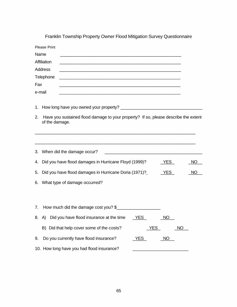
65
Franklin Township Property Owner Flood Mitigation Survey Questionnaire
Please Print
Name ____________________________________________________
Affiliation ____________________________________________________
Address ____________________________________________________
Telephone ____________________________________________________
Fax ____________________________________________________
e-mail ____________________________________________________
1. How long have you owned your property? 2. Have you sustained flood damage to your property? If so, please describe the extent
of the damage. _____________________________________________________________________ _____________________________________________________________________ 3. When did the damage occur? 4. Did you have flood damages in Hurricane Floyd (1999)? �YES �NO 5. Did you have flood damages in Hurricane Doria (1971)? �YES �NO 6. What type of damage occurred? 7. How much did the damage cost you? $ 8. A) Did you have flood insurance at the time �YES �NO
B) Did that help cover some of the costs? �YES �NO
9. Do you currently have flood insurance? �YES �NO 10. How long have you had flood insurance?

66
11. What suggestions do you have to reduce flood damages in the future*? 12. What incentives do you think that Franklin Township, the Federal Emergency Management Agency and others should offer to reduce flood damages?* 13. Additional comments - *Please continue on back of this sheet if necessary. Please return this questionnaire by September 23, 2002 to Ms. Bonnie von Ohlen by fax to 732-873-1059 to her attention or by mail to Ms. Bonnie von Ohlen, Franklin Township, 475 DeMott Lane, P.O. Box 6704, Somerset, New Jersey 08873-6704. Thank you for your participation in this critical initiative.

67
Letter to Neighboring Municipalities, State and County Agencies

68

69
September 3, 2002 RE: Township of Franklin Millstone River Flood Mitigation Project Dear Sir: This is to advise you that the Township of Franklin is in the process of developing a Flood Mitigation Plan funded by the grant from the Federal Emergency Management Agency (FEMA) through the State Office of Emergency Management . We are providing this notification so as not to duplicate or interfere with other flood plain management activities nearby and ask that you advise us of any activity, either proposed or in place, which may impact on our Plan and its implementation. Please reply to this request to Greg Westfall, USDA Natural Resources Conservation Service, by no later than September 30, 2002. He can be reached at [email protected] or 732-246-1171 X165. Thank you for your anticipated cooperation. Kenneth Daly Township Manager cc: file Distribution List

70

71
September 24, 2002 Public Hearing Minutes

72

73
2. PUBLIC HEARING – FLOOD PLAN
Bonnie Von Ohlen, Grant Coordinator, noted that the Township has received a FEMA Administrative Grant for preparation of a flood mitigation plan for the Millstone River. A contract has been authorized with the USDA, Natural Resources Conservation Service to prepare the Plan. Part of the Plan preparation required in order to receive future FEMA grants is community outreach. Notices have been sent to 100 property owners living in areas believed to be affected by the Millstone River. This public hearing has been scheduled to present to the Council and the affected property owners what the plan will include and receive comments from the public.
Greg Westfall of the USDA made the following presentation:
FRANKLIN TOWNSHIP FLOOD MITIGATION PLAN
USDA Natural Resources Conservation Service In cooperation with Franklin Township
New Jersey State Office of Emergency Management Federal Emergency Management Agency
September 24, 2002
INTRODUCTION
I. Purpose – To provide a flood mitigation plan to permit future
FEMA or other federal or state funding to perform various mitigation activities such as acquisition, elevation and relocation of flood-prone structures by interested homeowners and business owners.
PROPOSED SCOPE OF WORK
Community Organization I. Planning through a locally-led Township Flood Mitigation
Planning Committee made up of the following representatives: A. Township Engineer B. Office of Emergency Management C. Environmental Commission D. Planning Board E. Historic flood victims
Public Involvement
I. Public meeting to obtain public input on flood problems and possible solutions
II. Public meeting to obtain public input on the draft plan III. Public outreach through letters, surveys and news
releases/legal notices

74
Coordination with Other Agencies I. Contact others including neighboring communities and local,
regional, state and federal agencies that implement floodplain management activities
II. Draft flood mitigation plan is sent to others (as shown above) for their comments
Assessing the Hazard I. A description of past flooding will be developed along with
inclusion of the Flood Insurance Rate Map and repetitive loss areas where flood damages have occurred two or more times
Assessing the Problem
I. Identification of repetitive loss structures as defined by the National Flood Insurance program
II. Identify the number and types of buildings subject to flooding III. Provide a description of the impact that past or predicted
flooding has on buildings, infrastructure, public health and safety IV. Provide a description of the need and procedures for warning
and evacuating residents and visitors V. Identify critical facilities such as fire stations, first aid squad,
etc., as well as institutions with vulnerable populations such as colleges, nursing homes, etc.
Set Goals I. Identify the Township‘s goals for floodplain management
Review of Possible Activities I. Identify where in the Township plans such as the storm water
management plan, open space inventory and Master Plan the following items are addressed:
A. Floodplain and storm water management regulations and their current regulatory effectiveness
B. Retrofitting, acquisition, flood proofing and insurance C. Other
Implementation of An Action Plan I. Identify recommendations for actions appropriate to the
Township’s resources, flood hazard and vulnerable properties showing who does what, when it will be done and how it will be financed
Plan Adoption I. Flood Mitigation Plan and later amendments are officially
adopted by the Township’s governing body

75
Plan Monitoring and Evaluation I. An annual evaluation report monitoring implementation,
reviewing progress, and recommending revisions to the plan will be prepared by the Township Flood Mitigation Planning Committee. Report to be submitted to the governing body, released to the media and made available to the public
A map on display indicates the 184,000-acre watershed that drains into the
Millstone River. Mr. Westfall noted that damming and other methods of controlling flood waters have been considered, but it was determined that the cost of these methods exceeded any potential loss of property. Therefore, mitigation has been selected as the appropriate course of action.
Deputy Mayor Grippo questioned if the Flood Mitigation Plan includes an Evacuation Plan, Shelters Plan, etc. Mr. Westfall responded that the current plan does not include these items. Township Manager Daly noted that the Township has such plans which were updated about a year ago.
This Plan concerns what the Township can do to mitigate the impact of flooding
on existing buildings and to insure buildings such as the East Millstone First Aid Squad are able to function during flood conditions.
Mr. Mazzola noted that the Township suffers significant, repetitive flooding involving residents and businesses along the northern border from Raritan River. Should both rivers flood at the same time, evacuation routes from one river could make evacuation routes from the other river impassable. Upon a motion made, seconded and agreed, the meeting was opened for public comment on the Flood Mitigation Plan.
Anton Lemli, 621 Canal Road, encouraged the Council to do everything to mitigate flood damage. His dwelling suffered substantial damage during flooding caused by Floyd, and flooding will continue to worsen as more land is developed.
Upon a motion made, seconded and agreed, the meeting was closed for public comment on the Flood Mitigation Plan.

76

77
October 2, 2002 Flood Mitigation Planning Committee Minutes

78

79
Franklin Township Flood Mitigation Planning Committee Meeting Minutes October 2, 2002
Welcome and Introductions Members attending were Bonnie von Ohlen, Township Grants Coordinator; Gary Howarth, Township Emergency Management Coordinator; Scott Thomas, Township Engineer’s Office; Pat Bacon, East Millstone First Aid Squad; Jeff Olszyk, Zarephath; Theodore Chase, Jr., Township Planning Board and Environmental Commission; Anton Lemli, flooded property owner and Greg Westfall, Water Resource Planner, USDA Natural Resources Conservation Service. Background of Flood Mitigation Planning Grant Bonnie von Ohlen reviewed the history behind the flood mitigation planning grant. The Township applied for the grant in November, 2002. The Township was notified of the approval of the grant in early June. Work on this project was delayed because the summer months were not conducive to a good public turnout in terms of public participation. Public hearing was held on September 24th to receive public inputs. Another public hearing is required following the completion of the draft Flood Mitigation Plan. The State OEM has given the Township a deadline of October 31st for completion of the draft Flood Mitigation Plan. State Office of Emergency Management/FEMA Flood Mitigation Program Features Greg Westfall reviewed the features of the Program as presented by Scott Duell, FEMA Region II at the September 27th Millstone River Watershed Steering Committee meeting as follows: Scott Duell of FEMA, Region II, covered the features of the Flood Mitigation Program. The Flood Mitigation Program (FMA) is a non-disaster-related program which provides an annual allocation to New Jersey of approximately $700,000. There are three parts of funding totaling $700,000 to New Jersey in the Program. One grant ($50,000) is for technical assistance to the State, in New Jersey’s case, the State Office of Emergency Management (OEM) at the New Jersey State Police. Another grant is for planning ($100,000) which is awarded to the Sate or subgrantee to create a plan which identifies risk to flooding and solutions. Plan must be adopted by the community and approved by FEMA. The third part is for project grants ($550,000) are provided through the State OEM to implement measures identified in the Flood Mitigation Plan. Measures must be environmental sound, technically feasible, and economically cost effective. Scott noted that a good rule of thumb is that the first floor is at or below the 10 year flood elevation. He also noted that historic values are considered but more as further justification for a project that is cost effective. In addition, eligible structures must be insured under the National Flood Insurance Program. Measures may include elevating, retrofitting (floodproofing), and acquisition. He noted that North Branch in Branchburg Township, Somerset County, is receiving both Flood Mitigation Program and Hazard Mitigation Grant Program (HMGP) funding.

80
Association of State Flood Plain Managers Flood Mitigation Planning (Video) Greg Westfall presented a video on flood mitigation planning. The video gave examples of several communities and what they have done with flood mitigation planning. The video was produced by the Association of State Flood Plain Managers. Flood Mitigation Plan Requirements Greg presented the flood mitigation plan requirements or steps. They are as follows: 1. Committee Organization 2. Public Involvement (throughout the entire process) 3. Coordination with Other Agencies 4. Assessing the Hazard 5. Evaluate the Problem 6. Set Goals 7. Review of Possible Activities 8. Draft Action Plan 9. Plan Adoption 10. Plan Monitoring and Evaluation Franklin Township Flood Mitigation Plan Map Needs Greg reviewed a list of needed maps for the Plan. 1. Franklin Township Location Map 2. Franklin Township Map showing the Millstone River watershed 3. FEMA Flood Insurance Study map for Franklin Township reduced (to fit on 11” x 17” or some other size page) that can be part of the Flood Mitigation Plan. 4. Air photo base map (using the newly available Somerset County 2000 air photo
base) showing individual structures, roads, etc in flood prone areas within the Millstone River watershed (Millstone River corridor and tributaries in Franklin Twp.) as follows:
FEMA Flood Plain Boundary NJDEP Special Flood Hazard Area Boundary NRCS HEC-2 Flood Plain Boundary Identification of repetitive loss structures Identification of the critical facilities (schools - e.g. Pillar of Fire at Zarephath, first aid squads - e.g. East Millstone First Aid Squad, North Brunswick Water Treatment Facility, Griggstown Sewage Pump Plant, Willow Creek Rehabilitation Center (formerly King James Nursing Home, etc.) Color coding of flood prone structures (buildings, roads, etc) based on the base flood elevation relative to the first floor, e.g., red for those where the elevation is six feet or more, orange where it is three to six feet and yellow where it is three feet or less. Base flood elevations used should be based on the NRCS developed (NJDEP and Somerset County Reviewed) HEC-2 model results.

81
Results of Public Survey on Flood Damages Bonnie von Ohlen reviewed the survey results. Over 100 surveys were sent to those people in the flood zone based on the lot and block address information obtained by NRCS and FEMA data sources. To date, 23 responses were received. Approximately 15-20 of the surveys were returned due to addressee moved, inadequate address, etc. The period of property ownership ranged from approximately 2 years to 49 years. Flood damages due to Hurricane Floyd flooding reported by twelve respondents. Four respondents also reported damages due to Hurricane Doria. Sixteen of the 23 (69%) respondents now have flood insurance for flood damages when the next flood occurs. Damages due to Hurricane Floyd flooding ranged from $200 to over $4,000,000 per property reporting. Total damages reported due to Hurricane Floyd flooding were $1.6 million. Open Discussion Pat Bacon reported that the East Millstone First Aid Squad has flood insurance through the VFIS (Volunteer Fireman Insurance Society). Gary Howarth noted that he had taken a Flood Mitigation Home Study Course and would copy pertinent parts of the course material and provide them to the Committee. There was considerable discussion regarding the high vulnerability and number of State-owned, historic structures. The group wondered whether the State currently has these structures covered by the National Flood Insurance Program. Also, the group asked whether these structures would be eligible for measures under this Flood Mitigation program. There was considerable discussion regarding road closure procedures during a flood emergency. During Hurricane Floyd flooding, Pat Bacon reported numerous instances of large trucks and cars on road such as Canal Road and South Middlebush Road which were trapped by rising waters of the Millstone River and Six Mile Run, respectively. Gary Howarth reported that there was a lack of barriers to stop people from proceeding down flood-vulnerable roadways. Pat Bacon suggested that there should be a gate installed on the south end of Canal Road at Route 518 near Rocky Hill. Similarly, a gate would be effective on South Middlebush Road. Greg reported that he had contacted the Somerset County engineering department regarding reconstruction of South Middlebush Road. He was informed that the road will likely be resurfaced and have intersection improvements but no realignment or raising of the road out of the two major flood-vulnerable areas. Ted Chase suggested that the Committee prioritize the structures in the Flood Mitigation Plan so that the limited dollars would have the greatest effect. He suggested that individual structures be shown for different flood levels. Greg noted that the intention would be to show the number and locations of structures affected under the 10, 50 and 100 year flood events. Ted recommended that any maps developed be retained in the Planning Board files so that, at the time of development application, the Board would be able to review the work.

82
Greg noted that he would like to have a copy of the various Township ordinances as they relate to flooding including but not limited to the flood plain ordinance, stormwater management ordinance, etc. Ted suggested that Bonnie provide Greg with contact information for Ellen Ritchie, Township Planner. Ted Chase noted that the Environmental Commission is looking at rerouting roof runoff water into the ground rather than allowing it to runoff to the streets. Pat Bacon asked whether there could be a multi-jurisdictional Flood Mitigation Plan for the Millstone River corridor. Greg noted that FEMA National Flood Insurance Program and the Flood Mitigation Program are apparently set up on a municipal basis. There was discussion regarding the flood damages which occurred in the Raritan River corridor during the Hurricane Floyd event. Over $4 million of damage occurred at the Willow Creek Rehabilitation Center, formerly King James Nursing Home, located on Easton Avenue alone. Also, flood damages occurred in the commercial district between the Center and Somerset Diner as the flooding completely covered Easton Avenue. Greg noted that NRCS does not currently have elevations for structures in this area as it does in the Millstone River watershed portion of the Township. Bonnie noted that the scope of the grant does not cover this area. The next meeting was scheduled for Tuesday, October 22, 2002 at 6 p.m.

83
October 22, 2002 Flood Mitigation Planning Committee Minutes

84

85
Franklin Township Flood Mitigation Planning Committee Meeting Minutes October 22, 2002
6 p.m. Welcome and Introductions Members attending were Bonnie vonOhlen, Franklin Township Grants Coordinator; Susan Herron, Superintendent of D&R Canal State Park; J. Gary Howarth, Franklin Township OEM; Pat Bacon, East Millstone First Aid Squad, Scott Thomas and Joe Russo, Franklin Township Engineering Department; Ted Chase, Franklin Township Planning Board and Environmental Commission and Greg Westfall, USDA Natural Resources Conservation Service. Minutes Review The minutes of the October 2, 2002 meeting were reviewed. First Draft Flood Mitigation Plan There was group consensus that photos need to be incorporated in the Flood Mitigation Plan. Pat Bacon and Sue Herron (and possibly Jeff Olszyk of Pillar of Fire at Zarephath) will be providing Greg Westfall with pictures. Greg distributed a summary of the number and types of structures, by municipality in the Millstone River corridor, affected by flooding. He will provide a Franklin Township summary of the number and types of structures affected by flooding in the Plan. Comments received: Page 6 - change Franklin Township Committee to Franklin Township Council Page 6 - drop Marisa Wieczorek and add Pat Bacon, East Millstone First Aid Squad change spelling of J. Gary Haworth to J. Gary Howarth Page 21 - a comment was made regarding date of Hurricane Floyd as shown in Table 1. It was agreed that either September 16 or 17th, 1999 would be accurate. Page 22 - there was also a comment received questioning whether Hurricane Floyd flooding was significantly greater than the 100 year event. Greg will follow-up with Bob Schopp of USGS. Page 25 - A comment was received that there was no Table 2. This will be remedied in the final draft plan. Page 27 - Gary Howarth indicated there now is a computerized (Dial-Logic) telephone alert system.

86
Page 31 - There was some discussion regarding the lack of any section on the Raritan River corridor flooding in the Plan. Gary noted that the VanWickel House, King James Nursing Home, the commercial strip along the north side of Easton Avenue and the Rutgers Preparatory School had been flooded during Hurricane Floyd. Greg noted that, unlike the Millstone River portion of the Township, NRCS does not have much information on the relative elevations of the various structures there and that if this was desired it would require additional NRCS time than was originally agreed to for this project. He noted that NRCS could include a short narrative on the past flooding that has occurred there. Page 32 - Reference to the specific location of the repetitive loss structure will be deleted. Page 32 - “twn” years change to ten years under reconstruction of Middlebush Road Page 35 - Franklin Township reference, drop the word “Basic” , should read Township of Franklin Emergency Operating Plan. Greg noted that the final plan will be desktop published by NRCS. First Draft Flood Mitigation Plan Maps It was the consensus of the group that the reference to specific addresses on maps included in the Plan was unnecessary. It was agreed that individual structures be identified on the 2000 DVRPC orthophoto maps from Somerset County showing those affected by the 10, 50 and 100 year flood events. J. Gary Howarth noted that there are evacuation plans for critical facilities (schools, nursing homes, etc). However, no flood evacuation route map exists. He will provide a proposed flood evacuation route map for inclusion in the next iteration of the maps. Other Discussion Greg noted that he had been in contact with Scott Duell, FEMA Region II regarding the possibility of a multi-jurisdictional flood mitigation plan as was suggested by Pat Bacon at the October 2nd meeting. FEMA would not have a problem with such an approach. It would require the notification, coordination and commitment of several other municipalities. Additional elevations are needed for the Weston Canal House as well as the buildings at Zarephath in terms of their relative vulnerability under various flood events.
87
There was discussion of the amount of impact of flooding on state-owned historic structures in the Millstone River corridor. Susan Herron noted that $110,000 had already been spent on the muletenders’ barracks at Griggstown and that another $25,000 had been spent on the Blackwells Mills Canal House (stone house) as a result of the Hurricane Floyd flooding. It was felt that any State spending to rehabilitate these structures should also include appropriate flood mitigation measures or else the investment would be wasteful long term. Susan referred Greg to Paul Sedor at NJDEP for further information on the plans for the historic structures. Susan Herron will contact the State Historic Preservation Office and provide a list of the State-owned historic structures and request values. Pat Bacon will contact the Meadows Foundation regarding the Franklin Inn. Recent costs for elevation of structures under the FEMA Flood Mitigation Program in North Branch were discussed. It was noted that these structures were located in a National and State Historic District. Concern was expressed regarding the altering of historic structures. Susan Herron noted that Rockingham has been relocated three times since the original events occurred. Public Hearing Date Set A public hearing for review of the draft flood mitigation plan was set for Tuesday, November 19, 2002 at 6:30 p.m. Next Meeting Date The next meeting date for the Flood Mitigation Planning Committee was set for Wednesday, November 13, 2002 at 6:00 p.m.

88

89
November 13, 2002 Flood Mitigation Planning Committee Minutes

90

91
Franklin Township Flood Mitigation Planning Committee Meeting Minutes
November 13, 2002 Welcome and Introduction Bonnie von Ohlen, Township Grants Coordinator opened the meeting. Others in attendance included Mayor Shirley Eberle; Joe Russo, Township Engineer; Scott Thomas, Township Senior Engineer; Gary Howarth, Township OEM Coordinator; Anton Lemi, property owner; Jeff Olszyk, Pillar of Fire; Ted Chase, Township Planning Board; Environmental Commission; Steve Goodman, East Millstone First Aid Squad; and Greg Westfall, Natural Resources Conservation Service. Flood Mitigation Plan Comments Members reviewed the latest revision of the Plan. Ted Chase noted that the State Park historic buildings are the most vulnerable to flooding. It was noted that none of the State-owned buildings are covered by the National Flood Insurance Program but are covered under a State self-insurance program. It was also noted that at the October 22nd meeting a request was made to determine whether the State is incorporating appropriate flood mitigation technology in plans for the State Park historic structure rehabilitation. Greg reported that, as suggested by Susan Herron, D&R Canal State Park Superintendent, he had attempted to contact Paul Sedor both by phone and e-mail and had not yet received a response. Greg will follow up with Susan. Ted also noted that the Franklin Inn is another Township concern due to its historic nature. It is currently used by the Meadows Foundation who leases it for a book store. Joe Russo suggested that Route 527 (Easton Avenue) be added to page 5 and that we may want to change Hurricane Floyd to more technically correct Tropical Storm Floyd. Joe also suggested that the Preliminary Damage Assessment Report, done following the Hurricane Floyd event, be included in the Plan Appendix. Greg will follow-up with this. Anton Lemli asked whether there would be structure-specific information in the Plan. Greg noted that individual structure analyses were not within the scope of the project. A table, without addresses or lot and block numbers to maintain property owners’ confidentiality, showing the first floor flood depth under various flood event scenarios will be included in the Plan. A summary table showing the category (commercial, institutional, historic, residential) and number of structures in each

92
category vulnerable to these various flood events will also be incorporated. Anton suggested that there be a table to categorize structures by the type of treatment. There was a recommendation that there be a section under recommendations to cover the special problem with historic structures noting that not only historic structure integrity but also structure location, particularly for the highly vulnerable muletenders’ barracks, is critical. Since flood proofing, elevating, relocating or demolishing these structures is not feasible in terms of historic preservation, it was suggested that the utilities be moved out of the basements and, in some cases, out of the first floor to an upper level. Further it was suggested that, where first floors are vulnerable, all valuable contents should be moved to the upper floor. Ted Chase noted that the Blackwells Mills Canal House currently has a Meadows Foundation meeting room on the first floor and a residence on the second floor. The Committee asked Greg to incorporate a recommendation in the Plan that the State of New Jersey obtain National Flood Insurance Program flood insurance coverage so that it would be eligible for Flood Mitigation implementation funding under this Plan. It was suggested that there be a section about the traffic interruptions posed by flooding at the Route 514 (Amwell Road), Blackwells Mills Road, Griggstown and, at times, the Route 27 crossings of the Millstone River. Section will incorporate the number of vehicles using the crossings and the length of time that the crossing is closed due to flooding. Comments on Maps It was recommended that the existing Flood Mitigation Plan Map have the scale shown to 1”=2000’. Anton Lemli noted that for areas not covered by the Somerset County topographic map showing structure locations, there is a State Park map sowing the location of houses on the Canal. He suggested that contact be made with Susan Herron or Jim Amon to share this information with Tom Tiner of Civil Solutions for incorporation into the Plan maps. He offered to share his copy if it is unavailable from these sources. Status of Evacuation Route Map Gary Howarth discussed a flood evacuation route map that he had developed. This map will be provided to Tom Tiner, Civil Solutions for entering into a GIS environment. There was considerable discussion regarding development of emergency access to Route 287 off of Elizabeth Avenue. It was noted that Elizabeth Avenue is the only access/evacuation route out of South Bound Brook in the event of a flood. Joe Russo reported that he will be attending a meeting regarding Route 287 interchanges and that this issue will be discussed. Photos for Flood Mitigation Plan

93
It was noted that at the October 22nd meeting offers to provide flood photos were made by Pat Bacon and Susan Herron. Steve Goodman suggested that contact be made with the local newspapers and possibly with the television networks for the aerial videos/pictures taken during Hurricane Floyd. Jeff Olszyk, Pillar of Fire, offered to share photos of past flooding at Pillar of Fire, Zarephath. Other Flood Damage Prevention Ordinance and Overlay Flood Zoning Greg noted that the Franklin Township Flood Damage Prevention Ordinance is included in the Appendix. He also requested and received a review of the ordinance by Clark Gilman of the Flood Plain Management Section, NJDEP. Gilman recommended several changes particularly in the definitions portion and one change in the variance section of the ordinance. These recommendations are also shown in the Appendix. Greg noted that Anthony Mangeri, State OEM, had suggested at the Millstone River Steering Committee meeting on October 31st, that flood vulnerable communities should consider adding an overlay flood zone to their zoning map. Scott Thomas noted that the flood zone is shown on the tax map. Ted Chase noted an overlay zone would raise the visibility of the flood zone. He also noted that the Planning Board can not preclude building from a stream more than 50 feet (NJDEP regulation). He stated that it is possible for building to occur within the flood zone and still be 50 feet or more from the stream. Next Meeting Date There was no future meeting date set. Greg asked that comments be made on the Plan and maps no later than Wednesday, December 4th. Public Hearing Date Bonnie asked the group regarding the best dates for a final public hearing to review and comment on the final draft plan. Greg noted that he anticipates having a desktop published draft plan by early December. Members chose Wednesday, December 11th at 7 p.m. as the date. Hearing will take place in the Township Council meeting chambers. Bonnie noted that she would be sending letters to the approximately 100 property owners invited to the first public hearing. Ted Chase suggested that the renters of the State Park historic properties also be added to the list. Bonnie will contact Susan Herron, D&R Canal State Park, for this information.

94
Ted asked Greg what NRCS expected to do during the public hearing and suggested a Power Point presentation minimizing discussion of the process and emphasizing the recommendations. Greg noted that a Power Point presentation plus hard copies of the draft plan will be made available. There was discussion regarding possible questions on the Raritan River flooding. Greg noted that he and Bonnie had incorporated the several paragraphs describing the flooding in that location and the recommendations would cover this area as well. He noted that, unlike the Millstone River corridor where NRCS has acquired structure elevation and hydraulic modeling data, there is no readily available data of this type for the Raritan portion of the Township.

95
December 11, 2002 Public Hearing

96

97
December 11, 2002 Public Hearing Welcome and Introduction Greg Westfall, Water Resource Planner, with the USDA Natural Resources Conservation Service (NRCS) opening the hearing by welcoming attendees and asking members of the Franklin Township Flood Mitigation Committee to introduce themselves. Members of the Flood Mitigation Committee attending included J. Gary Howarth, Municipal Emergency Management Coordinator; Jeff Olszyk, Pillar of Fire Community; Joe Russo, Township Engineer; Scott Thomas, Township Senior Engineer; Ted Chase, Planning Board and Environmental Commissioner; and Bonnie von Ohlen, Township Grants Coordinator. Members of the public in attendance included John H. Walker, 63 Claremont Road; John and Kathleen Petrowski, 1020 Canal Road, Griggstown; Bruce J. Allen, 1097 Canal Road, Griggstown; and Tom Kulik, 1079 Canal Road, Griggstown and Winston G. Belmar, 69 Dahmer Road, Somerset. Power Point Handout Greg reviewed the Power Point handout (attached). Greg reviewed slides on public participation, the Plan elements and recommendations for public information, private property flood mitigation, evacuation route enhancement, incorporation of flood mitigation planning into local ordinances and master planning, and public property, institutional and critical facility flood mitigation. Discussion John Walker asked whether NRCS used the FEMA Flood Insurance Study 100-year flood elevation for its analysis of which structures were flooded to the first floor. Westfall responded, that NRCS, with FEMA approval, had used an NRCS 100 year flood elevation (approximately 0.5 foot higher than the FEMA 100 year elevation) to determine the number and type of structures impacted. This value was considered by the FEMA people to be on the conservative side in that it includes more properties than likely would be the case with the FEMA elevation developed in the 1970s. While FEMA has recommended that the NRCS model results be used for analyzing the number and frequency of flooding of structures for this Plan, this does not necessarily mean that FEMA is revising the official FEMA map. Bruce Allen asked whether a recommendation of the Plan will be to include an all-weather crossing of the Millstone River. Ted Chase, Flood Mitigation Planning Committee member, noted that this is a subject on which there has not been very much recent discussion. Greg noted that Ted had provided him with a copy of the draft D&R Canal State Park Development Plan that shows that the State would be interested in closing the Griggstown causeway. John Petrowski asked when the individual flood audits and structure surveys could be done. Greg responded that this would be dependent on Township action following an approved Plan.

98
Several comments were received from participants regarding the location of the FEMA 100 year flood zone and the fact that it was not shown all the way to the River. It was suggested that this be changed to reflect the entire 100 year flood zone. Also, the location of critical facilities, including sewer and water treatment plants, schools, nursing homes, first aide squad, etc. needs to be shown on the maps. Weston Canal Road should be changed to Weston Causeway. Wrap up Greg noted that the Committee hoped to have comments back from the public in a week. The draft will be sent out to neighboring municipalities, county, state and federal agencies for their review and comment during the next month.

99
February 27, 2003 Flood Mitigation Planning Committee Minutes

100
101
Franklin Township Flood Mitigation Planning Committee Meeting Minutes February 27, 2003
6 p.m. Members attending were Anton Lemli, Theodore Chase, Scott Thomas and Bonnie Von Ohlen. Meeting began at 6 p.m. Purpose of the meeting was to review comments received from the State Office of Emergency Management and Somerset County Engineering. It was noted by Ted Chase that the page numbers appeared in two different series and that this needs to corrected. Under the Review of Community Needs, Goals and Plans it was suggested that NRCS incorporate/summarize the Pillar of Fire Long Range Plan, the Delaware and Raritan Canal State Park Development Plan, the East Millstone Redevelopment Plan as well as pulling from the 1999 Master Plan. There was considerable discussion regarding the strict definition of repetitive losses. Greg noted that the FEMA definition would only allow one structure in the entire Township. It was noted that a number of structures have suffered multiple occurrences of flood damage. These structures are both privately and publicly (State-owned). Anton Lemli noted a Blackwells Mills structure where first floor flooding to 18 inches and four feet has occurred due to Hurricane Doria in 1971 and Hurricane Floyd in 1999, respectively. Greg will revise accordingly. There was some discussion of a rumor that the East Millstone First Aid Squad may be considering relocating their facility. It was agreed that this type of information should be incorporated in the Plan so that the First Aid Squad may be able to receive FEMA Flood Mitigation Plan implementation funding. Greg will follow up with member Pat Bacon. Greg noted that a Beneficial Functions section has been developed and a Franklin Township Critical Habitat Map is included. Ted Chase noted that the map does not show flood plain forest. Greg responded that the map uses the best available information from the NJDEP Landscape Project database. There was discussion regarding any development or redevelopment in the flood plain. Greg noted that there are significant areas that could be developed including the Island Farm area along Weston Causeway owned by Pillar of Fire. Ted Chase noted that Township zoning is for six acres along the River and Canal. He noted that the Canal Walk development, currently under construction, is the closest place to this area. Greg discussed his phone conversation with

102
Jeff Olszyk. There are a number of options that Pillar of Fire is considering including the idea of wetland mitigation banking. There was considerable discussion regarding whether or not to leave the recommendation for incorporating a flood zone overlay into the Township zoning map. Scott Thomas felt that the accuracy of the flood zone delineations was not dependable. He noted that the flood zone is currently shown on the tax map. He also noted that the Township will be soon receiving delivery on 100 foot scale, 2 foot contour topographic maps. Ted Chase felt that it was important that developers show the 100 year flood zone on their plans. The Committee decided to remove the incorporation of the flood zone overlay from the recommendations. The Committee also changed the timetable under Private Property Flood Mitigation to show identification of funding sources to include 2004 to 2007, individual property structure analysis and individual property flood audits in 2005 instead of 2004 and implement flood mitigation measures in 2006 instead of 2005. The Committee discussed the comment from Somerset County suggesting that it is acceptable to place a mobile home in the floodway if it is within an existing mobile home park. Joe Russo, Scott Thomas and Ted Chase indicated that there currently are no existing mobile home parks in the Millstone River flood zone and that the Township development regulations would not permit a mobile home park to be sited there. Meeting ended at 8 p.m.

103
Agency Comments on Final Draft Flood Mitigation Plan

104
105
State Office of Emergency Management Review of the Township of Franklin’s Draft Flood Mitigation Plan
1. Under Section “B”, Public Involvement, a copy of the questionnaire was included
on page 47. Please provide details on the responses received and note whether solutions were considered.
2. Under Section “C”, Coordination With Other Agencies, provide the following
information: a. Discuss contact with other agencies at the beginning of the planning process and the input received. b. Discuss the results of any meetings held with representatives of agencies to review common problems, development policies, mitigation strategies, inconsistencies and conflicts in policies, plans, programs and regulations. c. Discuss the responses received from the other agencies that have reviewed the draft flood mitigation plan and whether this information may change the plan. 3. Under Section “D”, Assessing the Hazard, provide a map of the known flood
hazards in the area. “Known Flood Hazards” means the floodplain shown on the Flood Insurance Rate Map (FIRM), repetitive loss areas, areas not mapped on the FIRM that have flooded in the past, and surface flooding identified in existing studies.
4. Under Section “E”, Assessing the Problem, provide the following information: a. Describe areas that provide natural and beneficial functions, such
as wetlands, riparian areas, sensitive areas, and habitat for rare or endangered species.
b. Provide a description of any development, redevelopment,
population trends, and a discussion of possible future development and redevelopment in the floodplain, watershed, and natural resource areas.
c. Provide more detail of the impact of flooding on the community. If
possible, provide a dollar amount for the preliminary damage assessment shown in the appendix to illustrate the impact of flooding on the economy and its tax base.
5. Under Section “G”, Review of Possible Activities, the plan must describe those
activities that were considered and note why they were or were not recommended. If an activity is currently being implemented, the plan must note whether it should be modified. Provide this information for the activities mentioned.
6. Under Section “H”, Implementation of an Action Plan, identify for each activity who will do what, when it will be done, and how it will be financed. Prioritize the

106
activities in order of importance. Also address post-disaster mitigation policies and procedures. Provide details on these specifics.
7. Under Section “I”, Plan Adoption, provide proof of adoption of the flood mitigation
plan by the community’s governing body.

107
Comments from Somerset County Engineering
February 4, 2003 Bonnie VonOhlen Grants Coordinator Township of Franklin 475 DeMott Lane Somerset, NJ 08873-6704 Re: Draft Flood Mitigation Plan Dear Ms. VonOhlen; Thank you for forwarding the Franklin Township Draft Flood Mitigation Plan to Somerset County for review. As we discussed during our telephone conversation on Friday, January 31, 2003, we are forwarding the following comments:
1. On page 22, the reference to the current re-design of the Griggstown Causeway should include information on the Agency doing the work, as well as the purpose of the re-design.
2. On Pages 12 and 92, there is reference to FEMA recommending the use of the NRCS hydraulic model for the Plan. Does this also indicate that FEMA is revising its mapping to adopt the NRCS study as the official FEMA delineation? This should be clarified.
3. The purpose of the subsection entitled Additional Techniques and Methods Used under Regulatory Activities: Existing Flood Plain Regulations and Recommendations for Change on Page 23 and 24 is unclear. Are these recommended revisions or changes to the existing NJDEP Flood Hazard Area Control Act, or to the Franklin Township Flood Damage Prevention Ordinance? Many of these items are unclear and potentially misleading, and should be clarified.
4. The “Action Needed by State and Somerset County”, on Page 31, can be interpreted as if the County has already investigated the feasibility of installing traffic gates and electronic warning signs, and has agreed to major changes to Middlebush Road. This is not the case. The paragraphs should be revised to include wording to the effect that the Franklin Township Flood Mitigation Committee is endorsing the concept of pursuing these options.
5. Section 135-17 (Floodways) of the Franklin Township Flood Damage Prevention Ordinance (page 117) indicates that it is acceptable to place a mobile home in the floodway if it is within an existing mobile home park. This should be clarified.
6. The paragraph “Geo-notification” on Page 29 is misleading and should be clarified. It is unclear as to how and by whom the information obtained by Franklin Township will be incorporated with the Somerset County Flood Information System. The Agency having the GIS Office should also be specified. Also note that the name Somerset County Flood Information and Warning System should be changed to Somerset County Flood Information System (SCFIS).

108
If you have any questions or require any additional information, please call me at 908-203-6026. Yours truly, Carl Andreassen Principal Hydraulic Engineer Cc: Mike Amorosa

109
EXCERPT FROM MINUTES – 1/7/03 WORKSESSION: 13. DRAFT FLOOD MITIGATION PLAN
Township Manager Daly noted that the draft plan is well done but there is concern that plan makes recommendations that can be very costly. The plan does not provide cost estimates, action timetable, or funding timetable, and he has communicated to the committee that, before the plan is finalized, they must address these practical issues.
Mr. Mettler noted that recommendations to move historic structures out of flood areas would not make sense in cases such as the bridge tender’s house. Other methods need to be considered and recommended.

110

111
Preliminary Damage Assessment Report for Hurricane Floyd Damages in Franklin Township

112

113
1. Tree down in the D.&R. Canal between 518 Canal Road and Coppermine Road. 2. Across from 1319 Canal Road, debris needs to be cleaned from culvert and channel. 3. South of 1213 Canal Road the guide rail is down and the culvert and channel need to be cleared of debris. 4. Between 1175 & 1179 Canal Road the small drainage ditch and culvert need to be cleared of debris. 5. 1170 Canal road (State Property @ Canal Lock) appears to have been inundated to
between 3 ½ to 4 feet above the road surface. Probable flooding of basements of structures up to the first floor. Mud and silt in parking areas.
6. Coppermine Road, at the bend near Jablonski’s property and up the hill in front of
133 there is evidence of failure of the edge of pavement due to undermining by fast flowing water in the road side ditches.
7. 1082 Canal Road shows probable water damage to contents. 8. Griggstown Causeway and Canal Road indicates flooding of the basements and
first floors of all State owned buildings (Historic). 9. Griggstown Park was inundated and the receding flood waters deposited piles of
vegetative debris and two portable toilets against the trees near the parking area. 10. Griggstown Causeway Bridge has debris piled up against the center pier and some debris wedged into the superstructure. The County Bridge Engineer has advised that there was no structural damage. 11. The white corner house on Canal Road at the Causeway (private) suffered flood
damage to the contents of the basement and first floor. A wood frame shed structure, perhaps 10 feet x 20 feet collapsed.
12. 1069 Canal Road (Nash Residence) had water 2 ½ feet above the first floor which may be 10 to 12 feet above Simonson’s Brook. There was no structural damage. Loss of contents in the basement and first floor. Oak flooring buckled. Electrical system appears to have survived but the condition of the furnace, hot water heater, etc. is not yet known. One large tree which has already been removed fell next to the driveway. The post and rail fencing has been washed out. The septic tank was probably under 12 to 14 feet of water. Conditions relative to the septic tank and system are not known.

114
13. Griggstown Reformed Church had a flooded basement to about 2 or 3 feet and some damage to their pipe organ. 14. 1036 Canal Road, the Thompson residence indicates possible flooding of the garage and shed. The house did not appear to have been flood to any great degree. 15. The Bunkerhill Road Environmental Center has about 100 feet of a combination paved and stone road washed out on the approach side of the secondary access wood bridge. The small bridge is undamaged. 16. The Bunkerhill Environmental Center primary entrance bridge has major wash out along the northwest wing wall. There are wash outs through the deck and parapet. Portions of the southeast parapet appear to have broken away. The design and permitting for the replacement of this bridge has been completed. Construction is awaiting funding. 17. New One Lane Canal Road Bridge (Timber Bridge with old iron trusses), north of Butler Road., has debris on the abutments and in the upstream channel. 18. The headwalls of two Canal Road stream crossings, north of Jacques Lane are broken. They may have been hit by vehicles. It is not clear if the damage is storm related. 19. The State Park offices, at Blackwells Mills, may have had water in the basement but there does not appear to be any serious damage. 20. The Lemli residence, circa 1823), on the southeast comer of Canal Road and Blackwells Mills Road had 4 to 5 feet of water for a period of about 15 hours. All major appliances were lost as well as all small kitchen appliances. Brick floors in the kitchen and pantry are okay. The original pine plank flooring may be warped. All drawers m the kitchen cabinets are warped and will probably have to be replaced. The entry door is swollen to the point where it can not be closed. The Lemlis are presently staying in their barn (garage) which is up slope from the dwelling and was not flooded. They have insurance but I was not able to find out what type of insurance. They had already done a major clean-up and were attempting to slowly dry out the wood floors with fans and low heat. 21. The art shop directly across from Lemli as well as the "Canal House", on the opposite comer, had about 4 feet or water above the first floor with resultant loss of contents. 22. The barn (garage) on Canal Road, for #611, had 4 feet of water above the grade level
floor and the exterior wood frame walls were wet to the same height. It appears that the two passenger vehicles, in the garage, had been moved prior to the flooding and therefore were not damaged.
23. The first culvert, north of Blackwells Mills Road, dated 1929, near 506 Canal Road has major erosion along the head wall closest to the D, & R. Canal.

115
24. The "Earth House" had 3 feet of water in the barn and basement of the office with some loss of contents. The Main house was okay and used as a refuge during the height of the flooding. The brook and road crossing south of # 517 Canal Road as well as between the main house and the barn and office is full of debris. 25. East Millstone First Aid Squad building was flooded to 2 1/2 feet above the apparatus room floor with a minor loss of contents. There is some evidence of possible foundation settlement to the weakening of the sub-soils by the flood waters. The lower southeast comer has what appear to be structural cracks in the masonry .The East and West walls have vertical masonry cracks and the South wall exhibits a series of random cracks. There is no immediate danger of structural collapse but the cause of the wall distress and a remedy should be determined. 26. Franklin Inn (Meadows Foundation) had basement flooding and about 2 1/2 feet of water above the first floor. Since this historic building was used as a library a substantial number of old books and documents were lost. 27. Building on the East side of Market Street, in East Millstone had water up to the top of the front stoops 3 Market Street had basement flooding and loss of contents occurred but the first floor level did not appear to be effected. 28. Onka Bus Garage had about the same amount of water, 2 1/2 feet or so, but there did not appear to be any major loss of contents. I have no information relative to fuel or automotive storage product storage. 29. Zarephath (Pillar of Fire) -refer to separate sheets attached. 30. Private dwelling at the entrance to Zarephath flooded to first floor level. Appears to be limited to loss of content. 31. 561 Canal Road had about 3 1/2 feet of water in the basement and garage. Appears to be loss of contents. 32. NJ Water Supply Authority Building flooded to first floor. 33. Randolph Brook crossing at Canal Road flood 2 to 2 1/2 feet above roadway.

116
34. FTSA Pump Station was probably inundated filling both wet and dry wells. Sewerage Authority Personnel on scene.
35. Easton Avenue from 287 to Landing Lane Bridge was impassable from Landing
Bridge to JFK Boulevard and in the vicinity of Lakeside Avenue near McAteer’s Restaurant. All low lying properties on the Canal side of Easton Avenue were inundated to a greater or lesser degree. Most experienced some loss of contents. It did not appear that there were structural problems.
36. The Willow Creek Rehabilitation Center, formerly King James Nursing Home, located on Easton Avenue to the west of the Unclaimed Freight had to have 168 patients evacuated to shelters and/or other medical facilities. It does not appear that the buildings sustained structural damage but there was damage to mechanical, electrical and medical equipment. There was a loss of bedding materials, kitchen equipment, supplies, etc.

117
Zarephath (Pillar of Fire Community) Vehicles: The listed vehicles were completed submerged in mud, silt and water while trying to be moved out of harms way. There were no injuries to persons. Van Plate No. 198-FZS Mini-Van Plate No. K2-38C Mini-Van Plate No. ACR-1874 Mini-Van Plate No. None Van Plate No. CRN-69C Van Plate No. YIC-325B Pick-Up Truck Plate No. XE-47GY Pick-Up Truck Plate No. VR-277A Station Wagon Plate No. HWZ-89L Passenger Car Plate No. JBS-94X “ Plate No. KG-292N “ Plate No. NN-918S “ Plate No. HVO-38H “ Plate No. SRS-6 “ Plate No. JV-303V “ Plate No. GHJ-39J “ Plate No. YA-586B “ Plate No. KN-915E “ Plate No. AAT-6004 “ Plate No. YA 608C “ Plate No. DORYCE In addition there were two semi-trailers and one flat bed truck (no cabs) which exhibited mud lines about 18 inches above their beds. Probable loss of contents and damage to brakes, wheels, bearings, etc. 51 persons were made homeless and are being sheltered elsewhere. Buildings Chapel - Flooded to 4 inches above the first floor. Floors in hallways buckled. Radio station on the second floor was off the air for 24 hours but did not sustain any damage.

118
1 Family Residence – Flooded to 7 feet above first floor. Contents in basement and first floor lost. Exterior deck, with furniture and plants, floated away as a unit. When the water receded, it cam to rest about 300 feet away at the rear of the Gym. Dam & Culvert - The small earth dam and culvert, between the upper and lower ponds, behind the meeting hall burst. Meeting Hall - Appears to be okay. 16 Weston Causeway - Slab on grade 1 ½ story single family residence had about 13 inches of water on the floor. Some contents and carpet lost. 18 Weston Causeway - Three story residence, once known as the Millwoods, had 12 inches of water on the first floor and a flooded basement. Basement contents and certain items on the first floor are lost. 5 Manville Causeway - Flooded into second floor. Structure appears to be intact. Lost all Furnishings and contents. High School - 4 inches on the first floor. Minimum damage. 1 Family Dwelling - Owned by the Pillar of Fire, had 4 inches of water on the first floor. Damage appears minimal. Gym - 5 ½ to 6 feet of water above grade. Basement flooded. Floor Seems to have to be okay. Contents lost. Library - Flooded to 4th shelf of book stalls. 1000’s of books lost. Main Building - Basement flooded. Water 5 ½ feet above the first floor. Office furniture, computers, commercial kitchen, dining room furniture, files, etc. destroyed and dining room floor buckled. Mechanical and Electrical equipment may need replacement. Student/Staff Housing - Water 18 inches above the porch. Basement and first floor flooded. Lost 2 complete apartments. Contents and furnishings. Other apartments okay. 2 Family Duplex – 2 ½ to 3 feet of water above first floor. Basement flooded. All contents and furnishings lost. 1 Family Bungalow - Water to underside of the roof soffit. Interior finishes, equipment and contents a complete loss.

119
Five Bay Garage - Complete loss of contents. Administration Building - Water 7 to 8 feet above grade. First floor bookstore and offices a complete loss. Ray White Chapel - Water to 10 feet. Carpeting and contents a complete loss. Old Dorm - 10 feet of water. This, circa 1910, building was not in use. Power House - 10 feet of water. Condition of boiler not yet determined. Maintenance equipment, stored in the building, probably a partial loss. Twelve Bay Garage - 12 feet of water. Loss of contents and possible loss of maintenance and automotive service equipment. 3 Family Residence - Flooded to 7 feet above first floor. Contents a complete loss. 1 Family Residence - Flooded to 7 feet above first floor. Contents a complete loss.

120

121
Table 2 – Franklin Township Structure Elevation and Flood Water Depths under Various Flood Events
Structure Elevations and Flood Water Depths under Various Flood Events (Table 2)

122
Table 2 - Franklin Township Structure Elevations and Flood Water Depths under Various Flood Events Description Structure
Category* Depth of Flood Water Above or Below (-) First Floor
structure elevations 1st Flr Low
Opng grnd 500 yr 100 yr 50 yr 10 yr 2 yr
5 car garage O 36.6 36.6 36.6 8.4 Note: The dike at Zarephath is 41.6 ft. at its lowest elevation. This height provides protection against all floods up to and including the 100 year event.
1 story residential no/bsmst
R 39.2 39.2 39.2 5.8
2 story residential w/bsmt R 42.5 37.5 40.1 2.6 Publishing Bldg no/bsmt I 38.4 35.2 35.2 6.7 Ray White Chapel I 36.7 33.8 35.1 8.4 unoccupied 4 stry bldg I 38.1 38.1 36.5 7.0 firehouse I 36.6 36.6 36.6 8.5 powerhouse I 37.6 37.6 37.6 7.5 Columbia Hall I 43.1 37.4 38.8 2.0 Main Bldg I 39.1 36.2 39.1 6.0 Library I 41.1 41.1 40.6 4.0 Main Chapel I 41.3 37.8 37.8 3.8 Wilson Gym I 38.9 32.2 32.2 6.2 7 bays/maintenance garage
O 38.7 38.7 38.7 6.5
2 story hse w/bsmt R 37.9 35.8 35.3 7.3 garage O 35.0 35.0 35.0 10.2 two story hse w/bsmt R 38.4 31.4 35.5 6.8 two story hse w/bsmt R 38.0 35.7 36.3 7.2 storage O 35.4 35.4 35.4 9.8 1 story hse w/bsmst R 38.4 36.5 36.5 6.8 3.0 1.2 -0.9 -2.9 3 story hse w/bsmt R 43.9 40.7 407 1.3 -2.5 -4.3 -6.4 -8.4 2 story hse w/o bsmt R 44.1 44.1 43 1.1 -2.7 -4.5 -6.6 -8.6 detached garage G 42.9 42.9 42.9 2.3 -1.5 -3.3 -5.4 -7.4 2 story hse w/o bsmt R 40.0 38.5 38.5 5.2 1.4 -0.4 -2.5 -4.5 commercial C 46.5 46.5 43.4 1.4 -2.3 -3.7 -6.1 -8.8 commercial C 43.4 43.4 43.4 4.5 0.8 -0.6 -3.0 -5.7 2 story commercial C 44.6 44.0 44.0 3.3 -0.4 -1.8 -4.2 -6.9 2 stry hse w/o bsmt R 43.3 43.3 43.3 4.6 0.9 -0.5 -2.9 -5.6 2 stry comm w/o bsmt C 46.0 46.0 46.0 1.9 -1.8 -3.2 -5.6 -8.3 2 stry hse w/bsmt R 46.8 44.8 44.8 1.1 -2.6 -4.0 -6.4 -9.1 2 story comm w/bsmt C 47.3 45.9 45.9 0.6 -3.1 -4.5 -6.9 -9.6 first aide squad I 44.6 44.6 44.6 3.3 -0.4 -1.8 -4.2 -6.9 2 stry hse w/bsmt R 48.7 46.5 46.5 -0.8 -4.5 -5.9 -8.3 -11.0 2 stry hse w/bsmt R 48.0 45.4 45.4 -0.1 -3.8 -5.2 -7.6 -10.3 post office I 49.2 46.9 46.9 -1.3 -5.0 -6.4 -8.8 -11.5 2 stry hse w/o bsmt R 48.2 48.2 47.8 -0.3 -4.0 -5.4 -7.8 -10.5 2 stry hse w/bsmt R 51.2 49.0 49.0 -3.3 -7.0 -8.4 -10.8 -13.5 1 story commercial C 51.4 50.0 50.0 -3.5 -7.2 -8.6 -11.0 -13.7 2 stry hse w/bsmt R 55.0 50.3 50.3 -7.1 -10.8 -12.2 -14.6 -17.3 barn O 44.8 44.8 44.8 4.1 0.4 -1.2 -3.9 -6.8 2 story hse w/bsmt R 55.6 48.6 48.6 -6.1 -9.8 -11.3 -14.1 -17.2 1 story studio R 44.1 44.1 44.1 5.4 1.7 0.2 -2.6 -5.7 shed O 44.8 44.8 44.8 4.7 1.0 -0.5 -3.3 -6.4 2 story w/o bsmt R 44.4 44.4 44.0 5.1 1.4 -0.1 -2.9 -6.0 2 story w/ basmt R 45.0 44.8 44.8 4.5 0.8 -0.7 -3.5 -6.6 small-historic bldg H 43.6 43.6 43.6 5.9 2.2 0.7 -2.1 -5.2

123
Table 2 - Franklin Township Structure Elevations and Flood Water Depths under Various Flood Events (Continued)
Description Structure Category*
Depth of Flood Water Above or Below (-) First Floor
structure elevations 1st Flr Low
Opng grnd 500 yr 100 yr 50 yr 10 yr 2 yr
2 story house w/basement
R 48.0 40.3 46.0 1.5 -2.2 -3.7 -6.5 -9.6
2 story house w/basement
R 48.7 44.1 47..7 0.8 -2.9 -4.4 -7.2 -10.3
2 story wdn gar/brn O 49.7 49.7 49.7 -0.2 -3.9 -5.4 -8.2 -11.3 1 stry garage O 49.7 49.7 49.7 -0.2 -3.9 -5.4 -8.2 -11.3 2 story hse w/o bsmt R 50.5 50.5 49.9 1.0 -2.7 -4.2 -7.2 -10.5 2 story hse w/bsmt R 55.0 49.8 49.8 -3.5 -7.2 -8.7 -11.7 -15.0 2 story hse w/bsmt R 54.5 52.9 52.9 -3.0 -6.7 -8.2 -11.2 -14.5 outbuilding O 49.9 49.9 49.9 1.6 -2.1 -3.6 -6.6 -9.9 1 story hse w/o bsmt R 52.0 52.0 50.8 -0.5 -4.2 -5.7 -8.7 -12.0 2 story hse w/o bsmt R 51.1 47.6 47.6 0.4 -3.3 -4.8 -7.8 -11.1 outbuilding O 45.8 45.8 n/a 5.7 2.0 0.5 -2.5 -5.8 2 story hse w/bsmt R 58.0 55.8 55.8 -6.5 -10.2 -11.7 -14.7 -18.0 2 story hse w/ bsmt R 56.0 48.3 48.3 -4.5 -8.2 -9.7 -12.7 -16.0 2 story hse w/obsmt R 54.2 54.2 50.5 -2.7 -6.4 -7.9 -10.9 -14.2 2 story hse w/bsmt R 53.9 51.5 50.6 -2.4 -6.1 -7.6 -10.6 -13.9 Reformed Chruch I 53.7 48.9 48.9 -2.2 -5.9 -7.4 -10.4 -13.7 2 story hse w/bsmt R 48.8 45.3 45.3 2.7 -1.0 -2.5 -5.5 -8.8 outbuilding O 43.7 43.7 n/a 7.8 4.1 2.6 -0.4 -3.7 muletenders house w/bsmt
H 42.5 40.0 40.5 9.4 5.7 4.3 1.3 -1.8
2 story hse w/obsmt R 44.1 44.1 47.6 7.8 4.1 2.7 -0.3 -3.4 1 story hse w/bsmt R 45.8 44.5 42.0 6.1 2.4 1.0 -2.0 -5.1 2 story hse w/bsmt R 50.8 48.7 49.3 1.1 -2.6 -4.0 -7.0 -10.1 1 story hse w/o bsmt R 52.4 52.4 49.2 -0.5 -4.2 -5.6 -8.6 -11.7 2 story hse w/bsmt R 46.8 38.8 38.8 5.1 1.4 0.0 -3.0 -6.1 2 story hse w/o bsmt R 44.5 41.5 41.2 7.4 3.7 2.3 -0.7 -3.8 2 story hse w/bsmt R 57.1 53.9 53.9 -5.2 -8.9 -10.3 -13.3 -16.4 2 story hse w/bsmt R 56.9 54.8 54.3 -4.9 -8.5 -10.0 -12.9 -16.1 2 story hse w/bsmt R 54.4 47.6 50.6 -2.4 -6.0 -7.5 -10.4 -13.6 2 car garage O 48.7 48.7 48.7 3.3 -0.3 -1.8 -4.7 -7.9 shed O 51.0 51.0 51.0 1.0 -2.6 -4.1 -7.0 -10.2 2 story hse w/bsmt R 53.0 49.6 49.8 -1.0 -4.6 -6.1 -9.0 -12.2 2 story hse w/bsmt R 58.9 50.9 52.0 -6.9 -10.5 -12.0 -14.9 -18.1 2 story hse w/bsmt R 59.0 56.8 55.0 -7.0 -10.6 -12.1 -15.0 -18.2 2 story hse w/o bsmt R 54.4 52.1 50.0 -0.5 -4.1 -5.5 -8.5 -11.6 2 story hse w/bsmt R 56.5 54.3 56.1 -2.6 -6.2 -7.6 -10.6 -13.7 3 story hse w/bsmt R 52.9 50.5 49.3 1.0 -2.6 -4.0 -7.0 -10.1 2 car garage O 52.5 52.5 51.8 1.4 -2.2 -3.6 -6.6 -9.7 cottage R 54.3 54.3 54.1 -0.4 -4.0 -5.4 -8.4 -11.5 red barn (stable) O 57.4 57.4 56.3 -3.5 -7.1 -8.5 -11.5 -14.6 white shed -2 stall O 57.4 57.4 55.8 -3.5 -7.1 -8.5 -11.5 -14.6 residential/commercial C 52.6 52.6 52.1 1.9 -1.7 -3.1 -6.0 -9.2 residential/commercial C 52.0 52.0 52.0 2.5 -1.1 -2.5 -5.4 -8.6 split level R 59.6 57.1 55.6 -5.1 -8.7 -10.1 -13.0 -16.2 C- Commercial H – Historic I - Institutional (First Aid Squad, Fire Station, School, etc. R – Residential O - Outbuilding (Garage, shed, etc.)

124

125
Franklin Township Flood Damage Prevention Ordinance

126

127
FLOOD DAMAGE PREVENTION
Chapter 135
FLOOD DAMAGE PREVENTION
ARTICLE 1 Purpose and Methods
135-1. Statutory authorization. 135-2. Findings of fact. 135-3. Statement of purpose. 135-4. Methods of reducing flood losses.
ARTICLE II Definitions
135-5. Word usage and definitions.
ARTICLE III General Provisions
135-6. Applicability. 135-7. Basis for establishing areas of special flood hazard. 135-8. Violations and penalties. 135-9. Abrogation and greater restrictions. 135-10.Warning and disclaimer of liability.
ARTICLE IV Administration
135-11.Development permit. 135-12. Designation of local administrator; powers and duties. 135-13. Appeals.

128
135-14. Conditions for variances.
ARTICLE V Provisions for Flood Hazard Reduction
135-15. General standards. 135-16. Specific standards. 135-17. Floodways. (HISTORY: Adopted by the Township Council of the Township of Franklin 5-22-80 as Ord. No. 994. Amendments noted where applicable.)
GENERAL REFERENCES Uniform construction codes - See Ch. 105 Development regulations - See Ch. 112. Quarrying and blasting - See Ch. 185. Soil removal - See Ch. 206.
ARTICLE 1 Purpose and Methods
135-1. Statutory authorization. The Legislature of the State of New Jersey has, in N.J.R.S. 40:48-2, delegated the responsibility to local governmental units to adopt regulations designed to promote the public health, safety and general welfare of its citizenry. Therefore, the Township Council of the Township of Franklin, New Jersey, does ordain as follows: 135-2. Findings of fact. A. The flood hazard areas of the Township of Franklin are subject to periodic inundation, which results in loss of life and property, health and safety hazards, disruption of commerce and governmental services, extraordinary public expenditures for flood protection and relief and impairment of the tax base, all of which adversely affect the public health, safety and general welfare.

129
B. These flood losses are caused by the cumulative effect of obstructions in areas of special flood hazard which increase flood heights and velocities, and, when inadequately anchored, damage uses in other areas. Uses that are inadequately floodproofed, elevated or otherwise protection from flood damage also contribute to the flood loss. 135-3. Statement of purpose. It is the purpose of this chapter to promote the public health, safety and general welfare and to minimize public and private losses due to flood conditions in specific areas by provisions designed to: A. Protect human life and health. B. Minimize expenditure of public money for costly flood-control projects. C. Minimize the need for rescue and relief efforts associated with flooding and generally undertaken at the expense of the general public. D. Minimize prolonged business interruptions. E. Minimize damage to public facilities and utilities, such as water and gas mains; electric, telephone and sewer lines; and streets and bridges located in areas of special flood hazard. F. Help maintain a stable tax base by providing for the sound use and development of areas of special flood hazard so as to minimize future flood blight areas. (Amended 4-11-1989 by Ord. No. 1476) G. Ensure that potential buyers are notified that property is in an area of special flood hazard. H. Ensure that those who occupy the areas of special flood hazard assume responsibility for their actions.

130
135-4. Methods of reducing flood losses. In order to accomplish its purposes, this chapter includes methods and provisions for: A. Restricting or prohibiting uses which are dangerous to health, safety and property due to water or erosion hazards or which result in damages increases in erosion or in flood heights or velocities. B. Requiring that uses vulnerable to floods, including facilities which serve such uses, are protected against flood damage at the time of initial construction. C. Controlling the alteration of natural floodplains, stream channels and natural protective barriers, which help accommodate or channel floodwaters. D. Controlling filling, grading, dredging and other development which may increase flood damage. E. Preventing or regulating the construction of flood barriers which will unnaturally divert floodwaters or which may increase flood hazards in other areas.
ARTICLE II Definitions
135-5. Word usage and definitions. A. Unless specifically defined below, words or phrases used in this chapter shall be interpreted so as to give them the meanings they have in common usage and to give this chapter its most reasonable application. B. As used in this chapter, the following terms shall have the meanings indicated: APPEAL - A request for a review of the Township Engineer’s interpretation of any provision of this chapter or a request for a variance.

131
AREA OF SHALLOW FLOODING - A designated AO Zone on the Flood Insurance Rate Map (FIRM). The base flood depths range from one (1) to three (3) feet, a clearly defined channel does not exist, the path of flooding is unpredictable and indeterminate; and velocity flow may be evident. AREA OF SPECIAL FLOOD HAZARD - The land in the floodplain within a community subject to a one-percent or greater chance of flooding in any given year. BASE FLOOD - The flood having a one-percent chance of being equaled or exceeded in any given year. BASEMENT - Any area of a building having its floor subgrade (below ground level) on all sides .(Added 9-8-87 by Ord. No. 1356) BREAKAWAY WALL - A wall that is not part of the structural support of the building and is intended, through its design and construction, to collapse under specific lateral loading forces without causing damage to the elevated portion of the building or supporting foundation system. (Added 9-8-87 by Ord. No. 1356) DEVELOPMENT - Any man-made change to improved or unimproved real estate, including but not limited to buildings or other structures, mining, dredging, filling, grading, paving, excavation or drilling operations located within the areas of special flood hazard. ELEVATED BUILDING - A nonbasement building built, in the case of a building in an area of special flood hazard, to have the top of the elevated floor above the ground level by means of piling, columns (posts and piers) or shear walls parallel to the flow of the water and adequately anchored so as not to impair the structural integrity of the building during a flood of up to the magnitude of the base flood. In an area of special flood hazard, “elevated building” also includes a building elevated by means of fill or solid foundation perimeter walls with openings sufficient to facilitate the unimpeded movement of floodwaters. In areas of coastal high hazard, “elevated building” includes a building otherwise meeting the definition of “elevated building” even though the lower area is enclosed by means of breakaway walls (Added 9-8-87 by Ord. No. 1356)

132
EXISTING MOBILE HOME PARK OR MOBILE HOME SUBDIVISION - A parcel or contiguous parcels of land divided into two (2) or more mobile home lots for rent or sale for which the construction of facilities for servicing the lot on which the mobile home is to be affixed, including, at a minimum, the installation of utilities, either final site grading or the pouring of concrete pads, and the construction of streets, is completed before the effective date of this chapter. EXPANSION TO AN EXISTING MOBILE HOME PARK OR MOBILE HOME SUBDIVISION - The preparation of additional sites by the construction of facilities for servicing lots on which the mobile homes are to be affixed, including the installation of utilities, either final site grading or pouring of concrete, or the construction of streets. FLOOD or FLOODING - A general and temporary condition of partial or complete inundation of normally dry land areas from:
(1) The overflow of inland or tidal waters; and/or
(2) The unusual and rapid accumulation or runoff of surface waters from any source. FLOOD INSURANCE RATE MAP (FIRM) - The official map on which the Federal Insurance Administration has delineated both the areas of special flood hazard and the risk-premium zones applicable to the community. FLOOD INSURANCE STUDY - The official report provided in which the Federal Insurance Administration has provide flood profiles, as well as the Flood Boundary - Floodway Map and the water surface elevation of the base flood. FLOODWAY - The channel of a river or other watercourse and the adjacent land areas that must be reserved in order to discharge the base flood without cumulatively increasing the water surface elevation more than two (0.2) foot. HABITABLE FLOOR - Any floor usable for living purposes, which includes working, sleeping, eating, cooking or recreation or a combination thereof. A floor used only for storage purposes is not a “habitable floor.”

133
LOWEST FLOOR - The lowest floor of the lowest enclosed area, including a basement. An unfinished or flood-resistant enclosure, usable solely for the parking of vehicles, building access or storage in an area other than a basement, is not considered a building’s “lowest floor,” provided that such enclosure is not built so as to render the structure in violation of other applicable non-elevation design requirements. (Added 9-8087 by Ord. No. 1356). MANUFACTURED HOME - A structure, transportable in one (1) or more sections, which is built on a permanent chassis and is designed for use with or without a permanent foundation when connected to the required utilities. For floodplain management purposes, the term “manufactured home” also includes park trailers, travel trailers and other similar vehicles placed on a site for greater than one hundred eighty (180) consecutive days. For insurance purposes, the term “manufactured home” does not include park trailers, travel trailers and other similar vehicles (Added 9-8-87 by Ord. No. 1356) MANUFACTURED HOME PARK OR MANUFACTURED HOME SUBDIVISION - A parcel or contiguous parcels of land divided into two (2) or more manufactured home lots for rent or sale. (Added 9-8-87 by Ord. No. 1356). MOBILE HOME - A structure that is transportable in one (1) or more sections, built on a permanent chassis and designed to be used with or without a permanent foundation when connected to the required utilities. It does not include recreational vehicles or travel trailers. NEW CONSTRUCTION -Structures for which the start of construction commenced on or after the effective date of this chapter. NEW MOBILE HOME PARK OR MOBILE HOME SUBDIVISION - A parcel or contiguous parcels of land divided into two (2) or more mobile home lots for rent or sale which the construction of facilities for servicing the lot, including, at a minimum, the installation of utilities, either final site grading or the pouring of concrete pads, and the construction of streets, is completed on or after the effective date of this chapter.

134
START OF CONSTRUCTION - For other than new construction or substantial improvements under the Coastal Barrier Resources Act (P.L. 97-348), includes substantial improvement and means the date the building permit was issued, provided that the actual start of construction, repair, reconstruction, placement or other improvement was within one hundred eighty (180) days of the permit date. The “actual start” means either the first placement of permanent construction of a structure on a site, such as the pouring of the a slab or footings, the installation of piles, the construction of columns or any work beyond the stage of excavation, or the placement of a manufactured home on a foundation. Permanent construction does not include land preparation, such as clearing, grading and filling; nor does it include excavation for a basement, footings, piers or foundations or the erection of temporary forms; nor does it include the installation on the property of accessory buildings, such as garages or sheds not occupied as dwelling units or not part of the main structure (Amended 9-8-87 by Ord. No. 1356). STRUCTURE - A walled and roofed building, a mobile home or a gas or liquid storage tank that is principally above ground. SUBSTANTIAL IMPROVEMENT - Any repair, reconstruction or improvement of a structure, the cost of which equals or exceeds fifty percent (50%) of the market value of the structure, either before the improvement or repair is started or, if the structure has been damaged and is being restored, before the damage occurred. For the purposes of this definition, “substantial improvement” is considered to occur when the first alteration of any wall, ceiling, floor or other structural part of the building commences, whether or not that alteration affects the external dimensions of the structure. The term does not, however, include either: (1) Any project or improvement of a structure to comply with existing state or local health, sanitary or safety code specifications which are solely necessary to assure safe living conditions; or (2) Any alteration of a structure listed on the National Register of Historic Places or a State Inventory of Historic Places.
135
VARIANCES - A grant of relief from the requirements of this chapter which permits construction in a manner that would otherwise be prohibited by this chapter.
ARTICLE III General Provisions
135-6. Applicability This chapter shall apply to all areas of special flood hazard within the jurisdiction of the Township of Franklin.
135-7. Basis for establishing areas of special flood hazard. The areas of special flood hazard identified by the Federal Insurance Administration in a scientific and engineering report entitled the “Flood Insurance Study for the Township of Franklin,” date November 1979, with accompanying Flood Insurance Rate Maps and Flood Boundary-Floodway Maps, are hereby adopted by reference and declared to be a part of this chapter. The Flood Insurance Study is on file at 475 DeMott Lane, Somerset, New Jersey 08873.
135-8. Violations and penalties. No structure or land shall hereafter be constructed, located, extended, converted or altered without full compliance with the terms of this chapter and other applicable regulations. Violation of the provisions of this chapter by failure to comply with any of its requirements, including violations of conditions and safeguards established in connection with conditions shall constitute a misdemeanor. Any person who violates this chapter or fails to comply with any of its requirements shall, upon conviction thereof, be fined not more than ($200) or imprisoned for not more than ninety (90) days, or both, for each violation, and, in addition, shall pay all costs and expenses involved in the case. Nothing herein contained shall prevent the Township of Franklin from taking such other lawful action as is necessary to prevent or remedy any violation.

136
135-9. Abrogation and greater restrictions.
A. This chapter is not intended to repeal, abrogate or impair any existing easements, covenants, or deed restrictions. However, where this chapter and other ordinance, easement, covenant or deed restriction conflict or overlap, whichever imposes the more stringent restrictions shall prevail. B. In the interpretation and application of this chapter, all provisions shall be:
(1) Considered as minimum requirements. (2) Liberally construed in favor of the governing body. (3) Deemed neither to limit nor repeal any other powers granted under state statutes.
135-10 Warning and disclaimer of liability. The degree of flood protection required by this chapter is considered reasonable for regulatory purposes and is based on scientific and engineering considerations. Larger floods can and will occur on rare occasions. Flood heights may be increased by man-made or natural causes. This chapter does not imply that land outside the areas of the special flood hazard or uses permitted within such areas will be free from flooding or flood damages. This chapter shall not create liability on the part of the Township of Franklin any officer or employee thereof or the Federal Insurance Administration for any flood damages that result from reliance on this chapter or any administrative decision lawfully made thereunder.
ARTICLE IV Administration
135-11. Development Permit.
A. A development permit shall be obtained before construction or development begins within any area of special flood hazard established in
135-7. Application for a development permit shall be made on forms furnished by the Township Engineer and may include but not be limited to plans, in duplicated, drawn to scale, showing the nature, location dimensions and elevations of the area in question, existing or proposed structures, fill, storage of materials, drainage facilities and the location of the foregoing.
B. Specifically, the following information is required: (1) The elevation, in relation to mean sea level, of the lowest floor, including a basement, of all structures. (2) The elevation, in relation to mean sea level, to which any structure has been floodproofed. (3) Certification by a registered professional engineer or architect that the floodproofing methods for any nonresidential structure meet the

137
floodproofing criteria in 135-16B. (4) A description of the extent to which any watercourse will be altered or relocated as a result of a proposed development.
135-12. Designation of local administrator, powers and duties.
A. The Township Engineer is hereby appointed to administer and implement this chapter by granting or denying development permit applications in accordance with its provisions. B. Duties of the Township Engineer shall include but not be limited to:
(1) Permit review. The Township Engineer shall: (a) Review all development permits to determine that the permit requirements of this chapter have been satisfied. (b) Review all development permits to determine that all necessary permits have been obtained from those federal, state or local government agencies from which prior approval is required. ( c) Review all development permits to determine if the proposed development is located in the floodway; if located in the floodway, assure that the encroachment provisions of 135-17A are met.
(2) Use of other base flood data. When base flood elevation and floodway data has not been provided in accordance with 135-7, basis for establishing areas of special flood hazard,

138
the Township Engineer shall obtain, review and reasonably utilize any base flood elevation and floodway data available from a federal, state or other source in order to administer 135-16A. Specific standards, Residential construction, and 135-16B, Specific standards, nonresidential construction. (Amended 9-8-87 by Ord. No. 1356) (3) Information to be obtained and maintained. The Township Engineer shall:
(a) Obtain and record the actual elevation, in relation to mean sea level, of the lowest habitable floor, including a basement, of all new or substantially improved structures and whether or not the structure contains a basement. (b) For all new substantially improved floodproofed structures:
(1) Verify and record the actual elevation, in relation to mean sea level. (2) Maintain the floodproofing certifications required in 135-11B(3).
( c) Maintain for public inspection all records pertaining to the provisions of this chapter.
(4) Alteration of watercourses. The Township Engineer shall:
(a) Notify adjacent communities and the state coordinating agency prior to any alteration or relocation of a watercourse and submit evidence of such notification to the Federal Insurance Administration. (b) Require that maintenance is provide within the altered or relocated portion of said watercourse so that the flood-carrying capacity is not diminished.
(5) Interpretation of FIRM boundaries. The Township Engineer shall make interpretations, where needed, as to the exact location of the boundaries of the areas of the special flood hazard (for example, where there appears to be a conflict between a mapped boundary and actual field conditions). The person contesting the location of the boundary shall be given a reasonable opportunity to appeal the interpretation as provided by 135-13 and 135-14.

139
135-13. Appeals A. The Board of Adjustment, as established by the Township of Franklin, shall hear and decide appeals and requests for variances from the requirements of this chapter. B. The Board of Adjustment shall hear and decide appeals when it is alleged that there is an error in any requirement, decision or determination made by the Township Engineer in the enforcement or administration of this chapter. C. Those aggrieved by the decision of the Board of Adjustment, or any taxpayer, may appeal such decision to the Superior Court, Law Division. D. In passing upon such applications, the Board of Adjustment shall consider all technical evaluations, all relevant factors, standards specified in other sections of this chapter and :
(1) The danger that materials may be swept onto other lands to the injury of others. (2) The danger to life and property due to flooding or erosion damage. (3) The susceptibility of the proposed facility to flooding or erosion damage. (4) The importance of the services by the proposed facility to the community. (5) The necessity to the facility of a waterfront location, where applicable. (6) The availability of alternative locations for the proposed use which are not
subject to flooding or erosion damage. (7) The compatibility of the proposed use with existing and anticipated
development. (8) The relationship of the proposed use to the Comprehensive Plan and
floodplain management program of that area. (9) The safety of access to the property in times of flood for ordinary and
emergency vehicles. (10) The expected heights, velocity during, rate of rise and sediment transport of the floodwaters and the effects of wave action, if applicable, expected at the site. (11) The costs of providing governmental services during and after flood conditions, including maintenance and repair of public utilities and facilities, such as sewer, gas, electrical and water systems and streets and bridges.
E. Upon consideration of the factors of Subsection D and the purposes of this chapter, the Board of Adjustment may attached such conditions to the granting of variances as it deems necessary to further the purposes of this chapter. F. The Township Engineer shall maintain the records of all appeal actions, including technical information, and report any variances to the Federal Insurance Administration upon request.

140
135-14. Conditions for variances.
A. Generally, variances may be issued for new construction and substantial improvements to be erected on a lot of one-half (1/2) acre or less in size contiguous to and surrounded by lots with existing structures constructed below the base flood level, provide that the items in 135- 13D(1) through (11) have been fully considered. As the lot size increases beyond the one-half (1/2) acre, the technical justification required for issuing the variance increases. B. Variances may be issued for the reconstruction, rehabilitation or restoration
of structures listed on the National Register of Historic Places or the State Inventory of Historic Places without regard to the procedures set forth in the remainder of this section.
C. Variances shall not be issued within any designated floodway if any increase in flood levels during the base flood discharge would result.
D. Variances shall only be issued upon a determination that the variance is the minimum necessary, considering the flood hazard, to afford relief.
E. Variances shall only be issued upon:
(1) A showing of good and sufficient cause.

141
(2) A determination that failure to grant the variance would result in
exceptional hardship to the applicant, and (3) A determination that the granting of a variance will not result in
increased flood heights, additional threats to public safety or extraordinary public expense, create nuisances, cause fraud on or victimization of the public as identified in 135-13D, or conflict with local laws and ordinances.
F. Any applicant to who a variance is granted shall be given written notice that
the structure will be permitted to be built with a lowest floor elevation below the base flood elevation and the cost of flood insurance will be commensurate with the increased risk resulting from the reduce lowest floor elevation.
ARTICLE V Provisions for Flood Hazard Reduction
135-15. General standards. In all areas of special flood hazard, the following standards are required:
A. Anchoring
(1) All new construction and substantial improvements shall be anchored to prevent flotation, collapse or lateral movement of the structure. (2) All manufactured homes shall be anchored to resist flotation, collapse, or lateral movement. Methods of anchoring may include but are not to be limited to use of the over-the-top or frame ties to ground anchors. This requirement is in addition to applicable state and local anchoring requirements for resisting wind forces. (Amended 9-8-87 by Ord. No. 1356)
B. Construction materials and methods.
(1) All new construction and substantial improvements shall be constructed with materials and utility equipment resistant to flood damage.

142
(2) All new construction and substantial improvements shall be constructed using methods and practices that minimize flood damage.
C. Utilities. (1) All new and replacement water supply systems shall be designed to minimize and eliminate infiltration of floodwaters into the system. (2) New and replacement sanitary sewage systems shall be designed to minimize or eliminated infiltration of floodwaters into the systems and discharge from the systems into floodwaters. (3) On-site waste disposal systems shall be located to avoid impairment to them or contamination from them during flooding. (4) Electrical, heating, ventilation, plumbing and air-conditioning equipment and other service facilities shall be designed and/or located so as to prevent water from entering or accumulating within the components during conditions of flooding. (Added 9-8-87 by Ord. No. 1356)
D. Subdivision proposals. (1) All subdivision proposals shall be consistent with the need to minimize flood damage. (2) All subdivision proposals shall have public utilities and facilities, such as sewer, gas, electrical and water systems, located and constructed to minimize flood damage. (3) All subdivision proposals shall have adequate drainage provided to reduce exposure to flood damage. (4) Base flood elevation data shall be provide for subdivision proposals and other proposed development which contain at least fifty (50) lots or five (5) acres, whichever is less.
E. (Added 9-8-87 by Ord. No. 1356) For all new construction and substantial improvements, fully enclosed areas below the lowest floor that are subject to flooding shall be designed to automatically equalize hydrostatic flood forces on exterior walls by allowing for the entry and exit of floodwaters. Designs for meeting this requirement must either be certified by a registered professional engineer or architect or must meet or exceed the following minimum criteria:
(1) A minimum of two (2) openings having a total net area of not less than one (1) square inch for every square foot of enclosed area subject to flooding shall be provided. (2) The bottom of all opening shall be no higher than one (1) foot above grade. (3) Openings may be equipped with screens, louvers or other coverings or devices, provided that they permit the automatic entry and exit of floodwaters.

143
135-16. Specific standards. In all areas of special flood hazard where base flood elevation data has been provided as set forth in 135-7, Basis for establishing areas of special flood hazard, or in 135-12B(2), Use of other base flood data, the following standards are required:
A. Residential construction. New construction and substantial improvement of any residential structure shall have the lowest floor, including a basement, elevated to or above the base flood elevation. B. Nonresidential construction. New construction and substantial improvement of any commercial, industrial or other nonresidential structure shall either have the lowest floor, including a basement, elevated to the level of the base flood elevation or, together with attendant utility and sanitary facilities, shall:
(1) Be floodproofed so that below the base flood level the structure is watertight, with walls substantially impermeable to the passage of water; (2) Have structural components capable of resisting hydrostatic and hydrodynamic loads and effects of buoyancy, and (3) Be certified by a registered professional engineer or architect that the design and methods of construction are in accordance with accepted standards of practice for meeting the applicable provisions of this subsection. Such certification shall be provided to the official as set forth in 135-12B(3)(b). (Amended 9-8-87 by Ord. No. 1356)

144
C. Mobile homes.
(1) Mobile homes shall be anchored in accordance with 135-15A(2). (2) All manufactured homes to be placed or substantially improved within a
area of special flood hazard shall be elevated on a permanent foundation such that the top of the lowest floor is at or above the base flood elevation. (Amended 9-8-87 by Ord. No. 1356)
135-17. Floodways. Located within areas of special flood hazard established in 135-7 are areas designated as “floodways.” Since the floodway is an extremely hazardous area due to the velocity of floodwaters which carry debris and potential projectiles and erosion potential, the following provisions apply:
A. Encroachments are prohibited, including fill, new construction, substantial improvements and other development, unless a technical evaluation demonstrates that encroachments shall not result in any increase in flood levels during the occurrence of the base flood discharge. B. If Subsection A is satisfied, all new construction and substantial improvements shall comply with all applicable flood hazard reduction provisions of this Article. C. The placement of any mobile homes is prohibited, except in an existing mobile home park or existing mobile home subdivision.

145
Suggested Changes to Existing Flood Damage Prevention Ordinance

146

147
Definitions: Development - add “or storage of equipment or materials.” Add Flood plain management regulations - means zoning ordinances, subdivision regulations, building codes, health regulations, special purpose ordinances (such as a flood plain ordinance, grading ordinance and erosion control ordinance) and other applications of police power. The term describes such State or local regulations, in any combination thereof, which provide standards for the purpose of flood damage prevention or reduction. Add: Historic Structure means any structure that is:
(a) Listed individually in the National Register of Historic Places, a listing maintained by the Department of the Interior or preliminary determined by the Secretary of the Interior as meeting the requirements for individual listing on the National Register; (b) Certified or preliminarily determined by the Secretary of the Interior as contributing to the historical significance of a registered historic district preliminarily determined by the Secretary to qualify as a registered historic district; ( c) Individually listed on a State inventory of historic places in States with historic preservation programs which have been approved by the Secretary of the Interior; or (d) Individually listed on a local inventory of historic places in communities with historic preservation programs that have been certified either:
(1) By an approved State program as determined by the Secretary of the Interior; or (2) Directly by the Secretary of the Interior in States without approved programs.
Add: Manufactured home means a structure, transportable in one or more sections, which is built on a permanent chassis and is designed for use with or without a permanent foundation when attached to the required utilities. The term “manufactured home” does not include a “recreational vehicle.” Revise: Start of Construction (for other than new construction or substantial improvements under the Coastal Barrier Resources Act (P.L. No. 97-348) includes substantial improvements and means the

148
date the building permit was issued, provided the actual start of construction, repair, reconstruction, rehabilitation, addition, placement, or other improvement was within 180 days of the permit date. The actual start means either the first placement of permanent construction of a structure on a site such as the pouring of a slab or footings, the installation of piles, the construction of columns, or any work beyond the stage of excavation, or the placement of a manufactured home on a foundation or permanent placement of a manufactured home on a foundation. Permanent construction does not include land preparation, such as clearing, grading and filling nor does it include excavation for a basement, footings or piers, or foundations or the erection of temporary footings or piers, or foundations or the erection of temporary forms, nor does it include the installation on the property of accessory buildings, such as garages or sheds not occupied as dwelling units or not part of the main structure. For substantial improvement, the actual start of construction means the first alteration of any wall, ceiling, floor, or other structural part of a building, whether or not that alteration effects the external dimensions of the building. Add: Substantial Damage means damage of any origin sustained by a structure whereby the cost of restoring the structure to its before damaged condition would equal or exceed 50 percent of the market value of the structure before the damage occurred. Revise: Substantial Improvement means any reconstruction, rehabilitation, addition, or other improvement of a structure, the cost of which exceeds 50 percent of the market value of the structure before the “start of construction” of the improvement. This term includes structures which have incurred “substantial damage”, regardless of the actual repair work performed. The term does not, however, include either:
(1) Any project for improvement of a structure to correct existing violations of State or local health, sanitary or safety code specifications which have been identified by the local code enforcement officer and which are the minimum necessary to assure safe living conditions; or (2) Any alteration of a “historic structure”, provided that the alteration will not preclude the structure’s continued designation as a “historic structure.”

149
Under Section 135-14. Conditions for Variances revise B to read as follows: Variances may be issued for the repair or rehabilitation of historic structures upon a determination that the proposed repair or rehabilitation will not preclude the structure’s continued designation as a historic structure and the variance is the minimum necessary to preserve the historic character and design of the structure.

150

151
Copy of Resolution Approving Flood Mitigation Plan

152
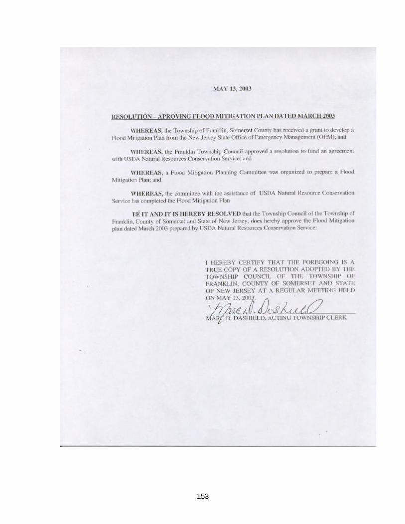
153

154

155
Federal Emergency Management Agency Flood Mitigation Plan Approval

156

157

158

159
Detail Map Index with Evacuation Routes and Structure Flood Vulnerability Detail Maps

160

161
Detail Map 1

162

163
Detail Map 2

164

165
Detail Map 3

166

167
Detail Map 4

168

169
Detail Map 5

170

171
Detail Map 6

172

173
Detail Map 7

174

175
Detail Map 8