Flood Investigation Report - cumbria.gov.uk · Flood Authority under Section 19 of the Flood and...
82
Millom and Haverigg Flood Investigation Report 30 th September 2017
-
Upload
nguyenhanh -
Category
Documents
-
view
217 -
download
0
Transcript of Flood Investigation Report - cumbria.gov.uk · Flood Authority under Section 19 of the Flood and...

Millom and Haverigg
Flood Investigation Report
30th
September 2017
Cumbria County Council
2 Serving the people of Cumbria
This flood investigation report has been produced by Cumbria County Council as a Lead Local
Flood Authority under Section 19 of the Flood and Water Management Act 2010.
Version
Undertaken by
Reviewed by
Approved by
Date
Draft
Helen Renyard /
Gavin Murray
Making Space for
Water Group
Doug Coyle
January 2018
Final
Helen Renyard /
Gavin Murray
Making Space for
Water Group
Doug Coyle
June 2018

cumbria.gov.uk 3
Executive Summary
Cumbria County Council as Lead Local Flood Authority (LLFA) has prepared this report with the
assistance of other Flood Risk Management Authorities as it considers necessary to do so
under Section 19 of the Flood and Water Management Act 2010.
Millom and Haverigg are situated on the west Cumbrian coastline in the south of the county with
Duddon estuary directly to the east. Many watercourses discharge into the estuary with Duddon
River as the primary source.
On 30th September 2017 an intense rainfall event occurred over Millom and Haverigg. The rain
soon overwhelmed the drainage systems and surface water began to rise, flooding an
estimated 255 residential properties including commercial.
As part of the investigations the LLFA has gathered information from affected residents by
means of site visits and a flood forum where members of the public provided information. Many
surveys of various assets in the area have been carried out including highway drainage
systems, public sewers including pumping stations and the performance of associated
watercourses.
From the information gathered it was identified that the cause of the flooding was due to the
intense rainfall event overwhelming the drainage assets, however, in some locations it may
have been compounded by faults on some of the drainage systems. Work has already begun
to repair identified faults.
The report also identifies recommended actions to reduce the risk of flooding for the future.
These actions are categorised as Community Resilience, Upstream Management, Maintenance
and Strengthening Defences.

Cumbria County Council
4 Serving the people of Cumbria
Contents Executive Summary .................................................................................................................................................... 3
Introduction ................................................................................................................................................................. 5
Scope of this Report ..................................................................................................................................................... 5
Event Background ...................................................................................................................................................... 6
Flooding Incident .......................................................................................................................................................... 6
Number of properties affected in Millom ....................................................................................................................... 7
Number of properties affected in Haverigg ................................................................................................................... 8
Investigation ................................................................................................................................................................ 9
Existing Flood Mapping ................................................................................................................................................ 9
Rainfall Event .............................................................................................................................................................. 13
Tides ........................................................................................................................................................................... 19
Asset Performance for Millom and Haverigg .............................................................................................................. 20
King Street Pumping Station - Millom ................................................................................................................ 22
Highway drainage and Cumbria County Council Assets ................................................................................... 24
Millom – Flood Affected Areas ........................................................................................................................... 25
Haverigg – Flood Affected Areas ....................................................................................................................... 38
Likely Causes of Flooding ........................................................................................................................................... 41
Flooding History .......................................................................................................................................................... 42
Recommended Actions ............................................................................................................................................ 44
Next Steps – Community & Catchment Action Plan ............................................................................................. 47
Appendices ............................................................................................................................................................... 49
Appendix 1: Glossary .................................................................................................................................................. 50
Appendix 2: Summary of Relevant Legislation and Flood Risk Management Authorities ......................................... 51
Appendix 3: UU Historic Works/Routine Maintenance/ Pumping Station Operation .................................................. 53
Desilting Programme .......................................................................................................................................... 56
Pumping Stations and Treatment works ............................................................................................................ 56
King Street Pumping Station Operation During Event ....................................................................................... 58
Appendix 4: LLFA Investigations ................................................................................................................................ 63
Crook Pool watercourse assessment ................................................................................................................ 63
Damaged Highway Drainage Assets ................................................................................................................. 69
Programme of Gully Emptying for Copeland ..................................................................................................... 71
Surveyed Highway Drainage Assets, including piped watercourses ................................................................. 72
Appendix 5: Environment Agency............................................................................................................................... 73
Appendix 6: Network Rail ........................................................................................................................................... 76
Appendix 7: Feedback from Residents and draft report ............................................................................................. 77
Appendix 8: Useful contacts and links ........................................................................................................................ 79

cumbria.gov.uk 5
Introduction
Under Section 19 of the Flood and Water Management Act (2010) Cumbria County Council, as Lead Local Flood Authority (LLFA), has a statutory duty to produce Flood Investigation Reports for areas affected by flooding. Section 19 of the Flood and Water Management Act states: (1) On becoming aware of a flood in its area, a lead local flood authority must, to the extent that it
considers it necessary or appropriate, investigate: (a) which risk management authorities have relevant flood risk management functions, and (b) whether each of those risk management authorities has exercised, or is proposing to
exercise, those functions in response to the flood. (2) Where an authority carries out an investigation under subsection (1) it must —
(a) publish the results of its investigation, and (b) notify any relevant risk management authorities.
This section of the Act leaves the determination of the extent of flood investigation to the LLFA. It is not practical or realistic for Cumbria County Council to carry out a detailed investigation into every flood incident that occurs in the County, but every incident, together with basic details will be recorded by the LLFA. Only those with 5 or more properties/businesses involved will have investigations published. An investigation will be carried out, and a report prepared and published by the LLFA when the flooding impacts meet the following criteria:
where there is ambiguity surrounding the source or responsibility of flood incident,
internal flooding of one property that has been experienced on more than one occasion,
internal flooding of five properties has been experienced during one single flood incident and
there is a risk to life as a result of flooding. .
Scope of this Report
This Flood Investigation Report is:
an investigation on the what, when, why, and how the flooding took place resulting from the 30th September 2017 flooding event and
a means of identifying potential recommendations for actions to minimise the risk or impact of future flooding.
This Flood Investigation Report does not:
interpret observations and measurements resulting from this flooding event. Interpretation will be undertaken as part of the subsequent appraisals,
provide a complete description of what happens next. The Flood Investigation Report outlines recommendations and actions that various organisations and authorities can do to minimise flood risk in affected areas. Once agreed, the reports can be used by communities and agencies as the basis for developing future plans to help make areas more resilient to flooding in the future. For further information on the S19 process, including a timetable of Flood Forum events and associated documentation, please visit the County Council website at:
http://www.cumbria.gov.uk/planning-environment/flooding/default.asp
To provide feedback on the report please email [email protected].

Cumbria County Council
6 Serving the people of Cumbria
Event Background
This section describes the location of the flood incident and identifies the properties that were
flooded.
Flooding Incident
Millom and Haverigg are located approximately 7 miles north of Barrow-in-Furness in the
southwest part of Cumbria as indicated in figure 1.
The parish of Millom currently has a population of approximately 7800 people which is divided
over three district council wards: Holborn Hill, Newton and Haverigg and two county divisional
wards, Millom and Millom Without.
Millom is a town which is located on the north shore of the Duddon Estuary and began as a new
town in the 1860s incorporating the existing Holborn Hill area. Holborn Hill originated as an
important place for travellers crossing the Duddon Estuary to access the west Cumbrian coast
with the railway station being opened in 1850.
Millom developed to support the local mining and ironworks in the area. However, these works
were closed at the end of the 1960s but the infrastructure constructed to accommodate these
works, such as the culverts remain and carry watercourses to this day.
Haverigg village is located along
the Cumbrian coast southwest of
Millom town. Areas of Haverigg
were used during the Second World
War as an airfield which later
became the site of HM Prison
Haverigg.
During 30th September 2017 Millom
and Haverigg were affected by a
band of torrential rainfall that
overwhelmed drainage systems in
the area of both Millom and
Haverigg. There were no weather
warnings in force at the time of the
event.
Millom
Haverigg
Figure 1: Location Plan

cumbria.gov.uk 7
Street Name External
flooding
Internal
flooding Total
Albert Street 2 27 29
Bowness Road 5 9 14
Crown Street 1 1
Cumberland Close 6 1 7
Derwentwater Close 2 2 4
Devonshire Road 1 1
Egremont Street 2 2
Earl Street 1 1
Finch Street 5 5
Haverigg Road 3 3
Holborn Hill 8 8
Kingsland Road 1 1
King St Garage 1 1
Lapstone Road 3 3
Lonsdale Road 3 6 9
Lowther Road 7 2 9
Mainsgate Road 3 14 17
Market Street 4 36 40
Moor Park 8 2 10
Moor Road 6 1 7
Palmers Lane 1 1
Nelson Street 1 5 6
Newton Street 4 4 8
Old Hope Street 1 1
Oxford Street 1 11 12
Palmers Lane 1 1 2
Pannatt Hill 1 2 3
Richmond Street 2 1 3
Rottington Cottages 4 4
Salthouse Road 1 1
Settle Street 3 3
St Georges Road 1 1
Surrey Street 1 17 18
Victoria Street 1 1 2
Wasdale Road 15 1 16
Wellington St 1 1
Windermere Gardens 1 1
Grand Total 78 177 255
Number of
properties affected
in Millom
A total of 255 properties were
affected by the flooding in
Millom.
243 of these were residential
and 12 were commercial
properties.
176 experienced internal
flooding and a further 79
experienced flooding to their
gardens/external sheds/out
buildings.
This list details the number of
properties per street.
Table 1: Numbers of
residential property flooding
listed by street in Millom

Cumbria County Council
8 Serving the people of Cumbria
Number of properties affected in Haverigg
Street name External
flooding
Internal
flooding Total
Bank End - 2 2
Green Street 1 1 2
Castle Terrace 1 - 1
Moor Moss - 1 1
Floyd Street 2 - 2
St Lukes Road 1 - 1
Wilson Avenue 1 - 1
Whiteriggs Close 2 2
Grand Total 8 4 12
Table 2: Numbers of property flooding listed by
street in Haverigg
In Haverigg 12 residential
properties were affected by the
flooding with 4 experiencing
internal flooding and a further 8
experiencing external flooding.
In addition to this 7
commercial properties were
affected by the flooding.

cumbria.gov.uk 9
Investigation
This section provides details of the authorities who have contributed to this
investigation, details of the rainfall event, likely causes of flooding and any previous
flood history of the area.
Information has been received from the United Utilities, Copeland Borough Council,
Environment Agency and the Highway Authority in order to assist with the compilation of this
report. In addition to this information provided by many of the residents at the first flood forum
has also been summarised within the report.
Existing Flood Mapping
The following information demonstrates the areas considered to be at risk from flooding based
on the flood risk maps produced by the Environment Agency. These maps are available to the
public and can be viewed via https://flood-warning-information.service.gov.uk/long-term-
flood-risk/map.
The following plan indicates the areas at risk of flooding from rivers or the sea. It can be seen
that the north-eastern side of Millom, including Huddleston Road and Millom Road have a low
risk of flooding from river or the sea.
Figure 2: Plan indicating flood risk from rivers and sea for Millom

Cumbria County Council
10 Serving the people of Cumbria
The following plan indicates the areas at risk of flooding from rivers or the sea for Haverigg and
it can be seen that there are various areas within Haverigg that are at risk from rivers or the sea.
Figure 3: Plan indicating flood risk from rivers and sea for Haverigg
The Environment Agency also provide plans for surface water flooding and it is these that
demonstrate the most significant flood risk for the majority of properties in Millom and Haverigg.
Not all areas of Millom and Haverigg are covered by the following plans but the main areas that
were affected by the flooding in September are.
Figure 4: Plan indicating flood risk from surface water for North Millom (Millom Road /
Albert Street etc.)

cumbria.gov.uk 11
Figure 5: Plan indicating flood risk from surface water for North Millom (Holborn Hill etc.)
Figure 6: Plan indicating flood risk from surface water for North Millom (Mainsgate Road /
Richmond Street etc.)
Indicates surface
water flood risk in
the Holborn Hill
area
Indicates surface
water flood risk in
Bowness Road /
Mainsgate Road
areas Indicates
surface water
flood risk in
Surrey Street /
Oxford Street
areas
Cumbria County Council
12 Serving the people of Cumbria
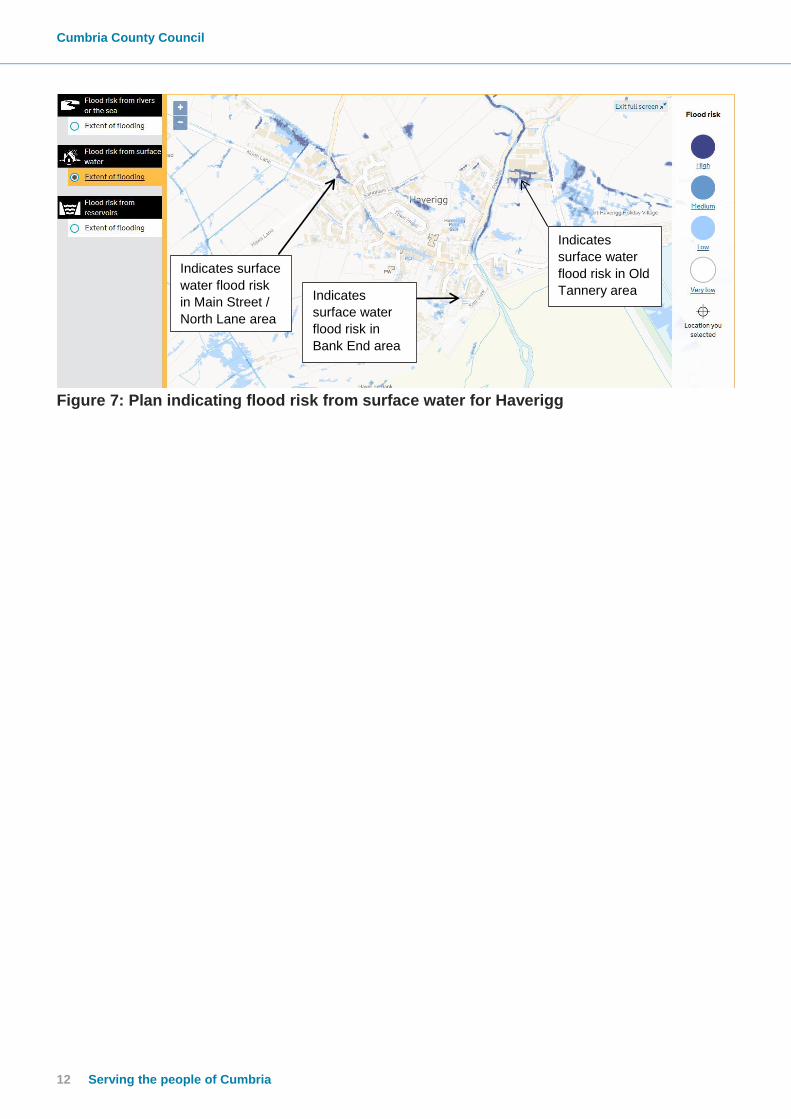
Figure 7: Plan indicating flood risk from surface water for Haverigg
Indicates surface
water flood risk
in Main Street /
North Lane area
Indicates
surface water
flood risk in
Bank End area
Indicates
surface water
flood risk in Old
Tannery area

cumbria.gov.uk 13
Rainfall Event
The event that affected Millom and Haverigg was caused by a narrow band of very heavy
rainfall which swept in on Saturday morning 30th September 2017 and affected parts of the
south of Cumbria which was roughly 15 miles wide. Stretching from the Duddon Estuary /
Millom area on the coast north-eastwards towards the Windermere / Ambleside area causing
some surface water flooding and affecting a number of properties on the Saturday morning.
There were no rainfall or weather warnings issued by the Met Office for the event, although a
weather warning had been issued for Sunday 1st October 2017.
Rainfall information has been collected from several sources and these are detailed as follows –
Metdesk rainfall data
The first source, Metdesk, is provided by the Metrological company used by CCC. The
information provided is taken from information provided by radar images.
The following information provides information on the rainfall that fell during the 30th September
2017 and also indicates average rainfall amounts for the area.
Figure 8: Rainfall volumes taken from radar
Cumbria County Council
14 Serving the people of Cumbria
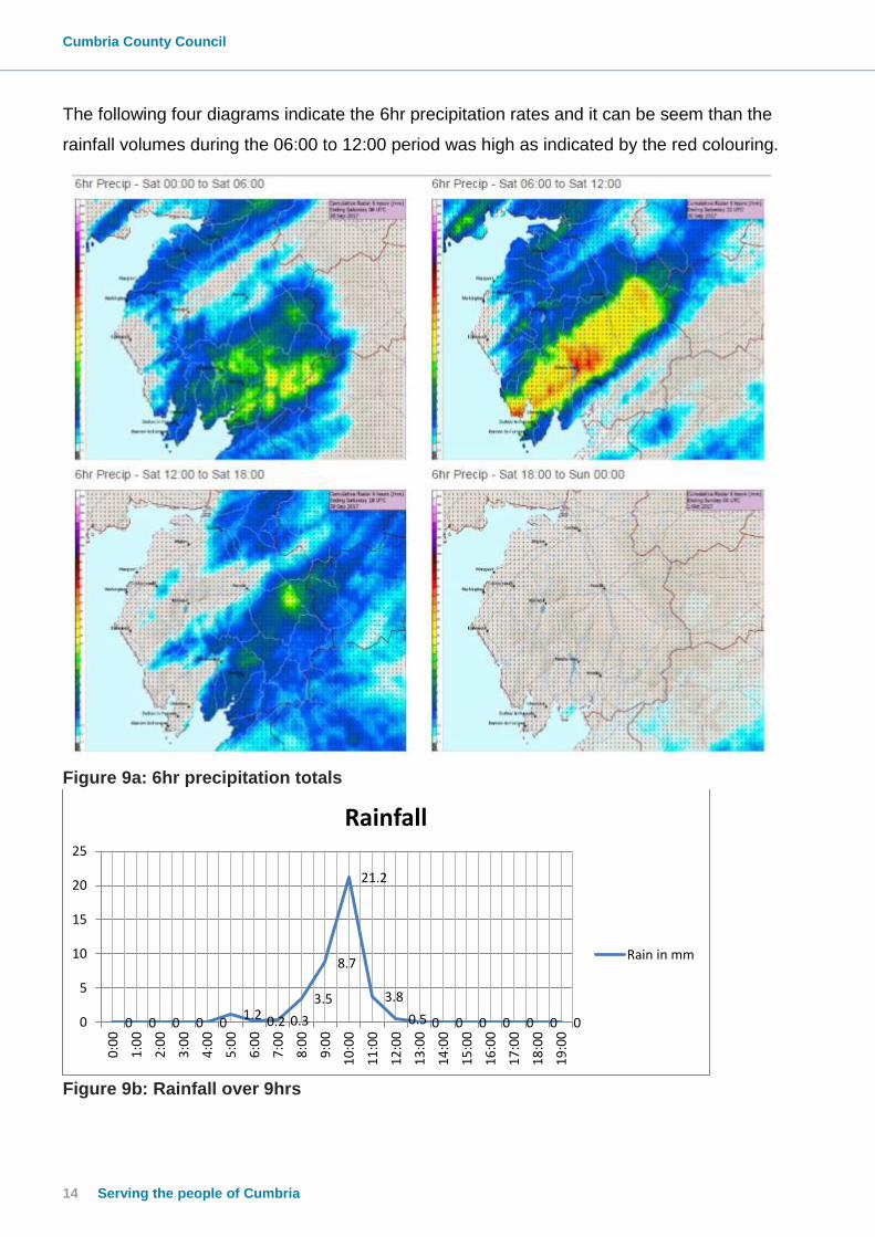
The following four diagrams indicate the 6hr precipitation rates and it can be seem than the
rainfall volumes during the 06:00 to 12:00 period was high as indicated by the red colouring.
Figure 9a: 6hr precipitation totals
Figure 9b: Rainfall over 9hrs
0 0 0 0 0 1.2 0.2 0.3
3.5
8.7
21.2
3.8
0.5 0 0 0 0 0 0 0 0
5
10
15
20
25
0:0
0
1:0
0
2:0
0
3:0
0
4:0
0
5:0
0
6:0
0
7:0
0
8:0
0
9:0
0
10
:00
11
:00
12
:00
13
:00
14
:00
15
:00
16
:00
17
:00
18
:00
19
:00
Rainfall
Rain in mm
cumbria.gov.uk 15
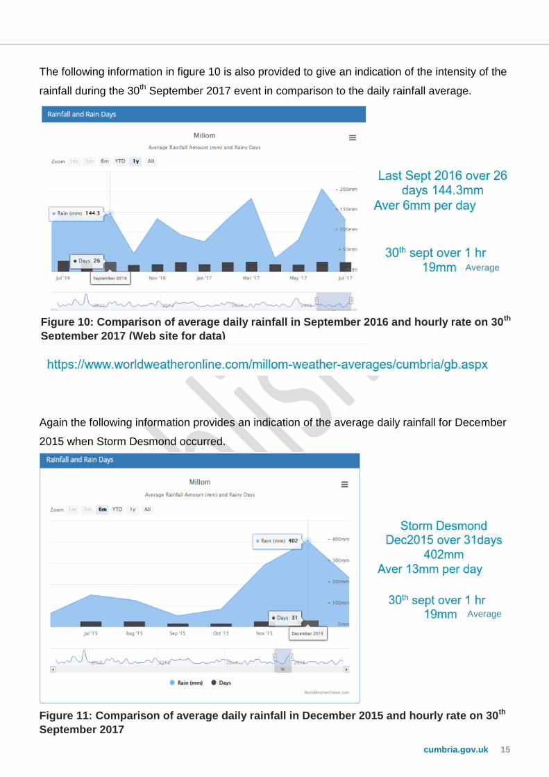
The following information in figure 10 is also provided to give an indication of the intensity of the
rainfall during the 30th September 2017 event in comparison to the daily rainfall average.
Again the following information provides an indication of the average daily rainfall for December
2015 when Storm Desmond occurred.
Figure 11: Comparison of average daily rainfall in December 2015 and hourly rate on 30th
September 2017
Figure 10: Comparison of average daily rainfall in September 2016 and hourly rate on 30th
September 2017 (Web site for data)
Average
Average

Cumbria County Council
16 Serving the people of Cumbria
The following information has also been obtained from the MetDesk’s Radar Analysis Tool
which is available to Cumbria County Council and indicates that on Mainsgate Road the hourly
rainfall total at 10am on 30th September 2017 was 21mm.
Figure 12: Information from MetDesk – hourly rainfall totals
With a peak rainfall of 19-21mm of rainfall within an hour it can be concluded that this was a
significant rainfall event.
Wunderground website (https://www.wunderground.com)
This website provides access to private rain gauges and there are 2 within the Millom and
Haverigg area that have provided a useful indication of rainfall during the event on the 30th
September 2017.
The first station is located on Lowther Road in Millom and the rainfall details are shown in the
graph below.
Figure 13: Wunderground rain gauge Lowther Road, Millom

cumbria.gov.uk 17
The rain gauge information from this site indicates that approximately 67mm of rainfall fell
between 7am and 10.30am with peak intensity of 97.3mm.
The rain gauge in Haverigg is located near to Richmond Gardens and the detail of this station is
below.
Figure 14: Wunderground rain gauge Richmond Gardens, Haverigg
The raingauge information from this site indicates that approximately 58mm of rainfall fell
between 7am and 10.30am with peak intensity of 63mm.
There is no information to determine if the data provided is calibrated on the Wunderground
website but the information is useful to demonstrate that this was a significant event.
Environment Agency rainfall data The nearest EA rain gauge is located approximately 5km from Millom at Lanthwaite. The information from the EA is detailed below for 30th September 2017.
Figure 15: Rainfall recorded at Lanthwaite rain gauge on 30th September 2017
This information shows significantly lower rainfall than appears to have been experienced in Millom and Haverigg. The following diagram helps to demonstrate why there was a significant difference between the EA raingauge and the other information gathered during this investigation.
0
1
2
3
4
5
6
00:00 03:00 06:00 09:00 12:00 15:00 18:00 21:00 00:00
Rai
nfa
ll m
m/1
5m
ins
Time
Rainfall recorded at Lanthwaite raingauge on 30th September 2017

Cumbria County Council
18 Serving the people of Cumbria
Figure 16: Location of Lanthwaite raingauge and rainfall radar data at 09:50 30/09/2017 The above radar information from Metdesk helps to show how there can be a significant difference in a short distance with regard to rainfall.
Millom Haverigg

cumbria.gov.uk 19
Tides
The information on tides has also been considered during the preparation of this report in order
to determine if there was also any unusual high tide at the time of the event which may have
impacted on the discharge of watercourses through the tidal flaps.
There is a tide monitoring station at Duddon Bar at the following location.
Figure 17: Duddon Bar information for day of event
Information on tides can be located from the following website -
https://www.tidetimes.org.uk/duddon-bar-tide-times.
From this it was determined that high tide occurred at 06:38 on the day of the event with low
tide at 13:11. There was no indication that there was any unusual high tide during this event
and it could be seen that the high tide on the 30th September was approximately 2.5m less in
height to those on 4th and 5th of October 2017 and therefore it was concluded that the tides did
not have an impact on the flooding during 30th September 2017.
Figure 18: Tide heights verses rainfall
0 0 0 0 0 1.2
0.2 0.3
3.5
8.7
21.2
3.8
0.5 0 0 0 0 0 0 0 0
5
10
15
20
25
0:0
0
1:0
0
2:0
0
3:0
0
4:0
0
5:0
0
6:0
0
7:0
0
8:0
0
9:0
0
10
:00
11
:00
12
:00
13
:00
14
:00
15
:00
16
:00
17
:00
18
:00
19
:00
Rain In MM
Tide
Cumbria County Council
20 Serving the people of Cumbria
Asset Performance for Millom and Haverigg
Public Sewers and United Utilities Assets
Public sewers are the statutory responsibility of United Utilities in both Millom and
Haverigg.
Millom and Haverigg are served by a public sewerage system that carries both foul and
surface water from properties, known as a combined system. This makes up
approximately two thirds of the network at Millom and Haverigg. The later housing
developments in the areas are served by a separate sewer and surface water system,
such as those on Lowther Road, Millom.
A common trait of older properties is for foul water and surface water, including highway
drainage to flow in a one piped system beneath the street. The properties built after the 1970s
have their foul water and surface water draining to separate systems and where possible
surface water is discharged direct to a nearby watercourse.
The main area that incorporates separate sewers is the development that incorporates
Bowness Road, Cumberland Close, Lowther Road etc., in this location much of the surface
water is discharged direct to a watercourse known as Crook Pool however this type of separate
system is uncommon in Millom.
New public sewers are built to a minimum national standard to accommodate a 1 in 30 year
design storm and any network improvements would also be designed to ensure the same
standard is met.
Two pumping stations make up part of the overall sewer system and assist with the transfer of
sewage to the wastewater treatment works. These pumping stations are located King Street,
Millom and to the east of Haverigg pool, Haverigg. See figure 18 on the following page.
It should be noted that the Millom and Haverigg systems work independently to one another,
however during periods of prolonged, heavy rain the station at Millom assists with additional
flows from Haverigg.

cumbria.gov.uk 21
The following diagram summarises the UU operational systems within Millom and Haverigg.
More detailed plans of the sewerage networks can be located within Appendix 3.
Figure 19: Summary of the main public sewer assets
The pumping station at King Street has been in existence for some considerable time but major
refurbishment of the station took place during 2013 to improve the quality of any discharge
direct to the Duddon Channel and forward treatment of greater capacity to the Waste Water
Treatment Works. Further UU detail is provided in at Appendix 3.
During the investigation and discussions with many of the residents it is often commented that
the pumps at the pumping station in King Street may not have been working during the event.
However, UU have provided information that demonstrates that the pumps were working to their
full capacity during the event. The following information provides details on the King Street
pumping station –
Haverigg Pumping Station
750mm Storm overflow to
Haverigg Pool
225mm rising main to
sewerage system in Millom
Sewage from
Haverigg enters the
Millom system in
this location
750mm sewer
into pumping
station
1200mm sewer into
pumping station
King Street pumping station
2000l/s Storm overflow to Sea
200mm and 500mm rising main to
wastewater treatment works
Wastewater
treatment works
Cumbria County Council
22 Serving the people of Cumbria
0 120
20 30
350
870
380
50 0 0 0 0 0 0 0 0 0
500
1000
1500
2000
2500
rain
Pump 1 l/s (200)
Pump 2 l/s (500)
Pump 1 to sea l/s (1000)
Pump 2 to sea l/s (1000)
Rainfall is superimposed on pump detail for timing only
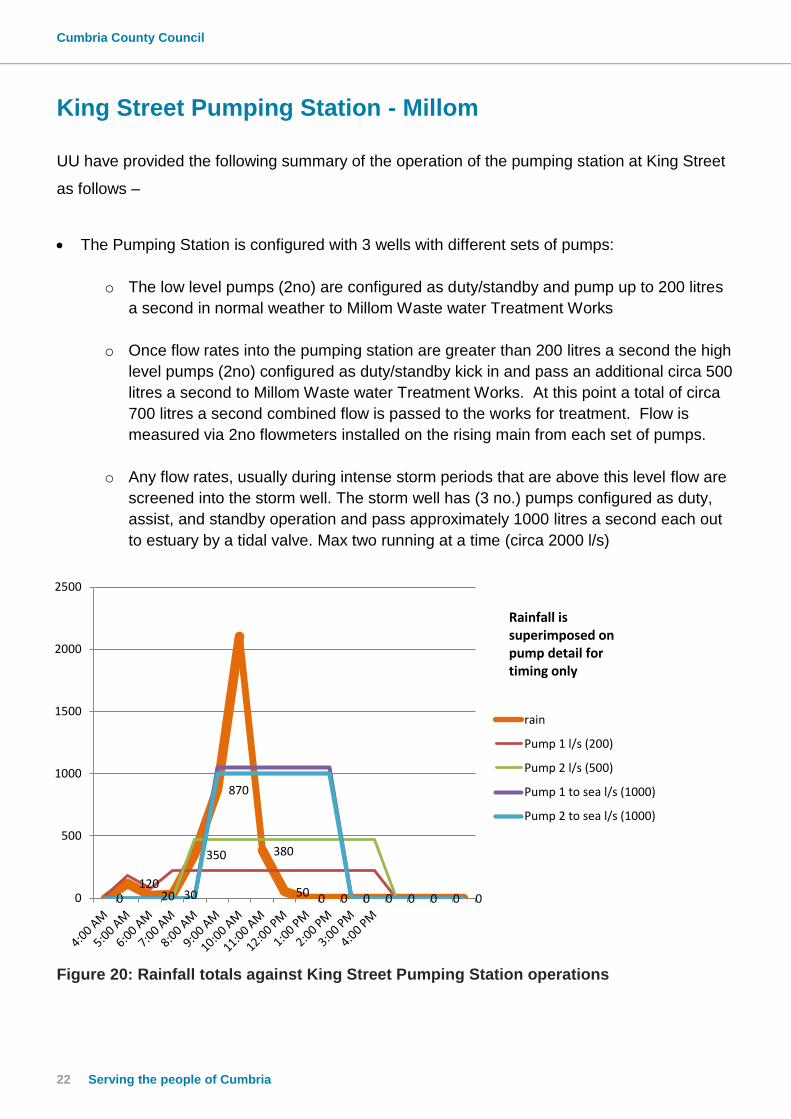
King Street Pumping Station - Millom
UU have provided the following summary of the operation of the pumping station at King Street
as follows –
The Pumping Station is configured with 3 wells with different sets of pumps:
o The low level pumps (2no) are configured as duty/standby and pump up to 200 litres
a second in normal weather to Millom Waste water Treatment Works
o Once flow rates into the pumping station are greater than 200 litres a second the high
level pumps (2no) configured as duty/standby kick in and pass an additional circa 500
litres a second to Millom Waste water Treatment Works. At this point a total of circa
700 litres a second combined flow is passed to the works for treatment. Flow is
measured via 2no flowmeters installed on the rising main from each set of pumps.
o Any flow rates, usually during intense storm periods that are above this level flow are
screened into the storm well. The storm well has (3 no.) pumps configured as duty,
assist, and standby operation and pass approximately 1000 litres a second each out
to estuary by a tidal valve. Max two running at a time (circa 2000 l/s)
Figure 20: Rainfall totals against King Street Pumping Station operations

cumbria.gov.uk 23
The following photograph shows the tidal valve at the discharge point from the King Street
Pumping Station. This is known as a duckbill check valve and allows water to flow in one
direction only. This does not restrict the volume of water that can escape from the pumping
station but serves to protect the pumping station from tidal flows.
Several residents refer to this valve as a tidal gate and were concerned that it was not open
during the event. The graph under figure 20, demonstrates this was not the case.
Photograph 1: Duckbill valve at King Street Pumping Station
As previously mentioned, any new systems are designed to accommodate up to 1 in 30 year
flood events. The historic combined sewer system throughout Millom may even be designed for
less. The event experienced on 30th September 2017 is believed to be beyond a 1 in 30 year
event and overwhelmed the system.
This is true for Cumbria County Council Assets; they too mostly rely on the historic combined
sewer system for drainage.

24 Serving the people of Cumbria
Highway drainage and Cumbria County Council Assets
Cumbria County Council are responsible for public highway drainage and maintenance
of gullies within the Millom and Haverigg areas.
Historically the majority of the highway gullies within Millom and Haverigg discharge direct to
the combined public sewerage system. More recent developments, such as Bowness Road
discharge highway runoff into a separate surface water system in addition to water from roofs
and other impervious areas such as driveways and patios. These then discharge directly to a
watercourse if possible, in this instance directly to Crook Pool.
Gullies are cleaned by CCC on an annual basis and the last cleaning of the gullies in Millom
and Haverigg prior to the event took place during July 2017. See schedule for 2017 at
Appendix 4
During the event many gullies were overwhelmed by the volume of rainfall experienced and
were not able to drain the surface water runoff away from the area as quickly as required as
the rainfall intensity was above the design capacity of gullies.
Following the event gullies in the flooded areas were checked and cleaned by CCC. An
extensive CCTV survey of drainage systems where it was considered there were issues has
taken place. These areas included the Bowness Road / Mainsgate Road area, and in
Haverigg, the Tannery Industrial Estate area, the Bank End / Sea View area and Main Street /
North Lane area. In these areas faults were found on some of the systems. These faults have
been identified in the section on flow routes and other relevant information.

cumbria.gov.uk 25
Millom – Flood Affected Areas
As the flooding covered such a large area the details of the flooded areas have been
broken down into smaller areas so that adequate detail can be provided for each area of
flooding.
Mainsgate Road / Bowness Road / Cumberland Close / Lowther Road
This area was significantly affected with 26 properties being affected with internal flooding and
20 properties affected by external flooding.
The following figures show details of the Networks recorded on United Utilities database
Mainsgate Road / Bowness Road /
Cumberland Close / Lowther Road
Surrey Street / Oxford Street /
Richmond Street / Wasdale Road
Lonsdale Road / Market Street /
Albert Street / Newton Street etc.
area
Finch Street / Settle Street
Holborn Hill / Victoria Street
Pannatt Hill Area
Figure 21: Flood Affected Areas - Millom

26 Serving the people of Cumbria
Figure 22: Plan of public sewer records
Combined Sewer
Foul Sewer
Surface Water Public
Sewer
Highways
Culverted Ordinary
Watercourse

cumbria.gov.uk 27
Figure 23: Location of issues on the surface water drainage systems in Mainsgate Road
and Bowness Road
During the investigations as detailed in Figure 23 several issues were found on the drainage
systems which are summarised as follows –
Seized flap valve – now removed
Collapse on the watercourse from Cumberland Close – to be programmed for repair in
the near future
Collapse on the culvert through the grounds of the factory – now repaired by United
Utilities
Badly damaged highway drain connection – now repaired by Cumbria County Council
4no damaged drains due to service installation – 1no gas and 3no electricity have now
been repaired, see photograph 2.
Crushed pipe rear of Bowness Road – the pipe is still operating but camera is unable to
progress – it has been established that this transfers surface water from fields to the
rear, to the public surface water system.
Issue due to
seized flap
valve Issue on highway
drain due to
electricity service
through drain
Collapsed
privately owned
box culvert –
repaired by UU
Collapse on
watercourse
leading to
the rear of
Cumberland
Close
Drain
connection in
poor condition
but not blocked
Issues with gully
connections due
to services – 2no
electricity and
1no gas
Crook Pool
watercourse
Unable to complete
survey due to
crushed pipe

28 Serving the people of Cumbria
As part of the investigations it was also noted that water levels in Crook Pool were at a high
level against the outfall from the surface water system from Mainsgate Road and as such the
LLFA also carried out a survey of the watercourse downstream to identify levels of the various
downstream watercourse crossings and culverts. The information from this survey is included
in this report as Appendix 4. Some issues were identified following this survey such as some
of the invert levels of the watercourse crossings are set at a high level which may impede flow
from the area. A minor collapse was also found on one of the crossings. The LLFA will be
working to address these issues with the relevant landowners. It is worth noting that these
crossings have been in existence for a considerable length of time.
Several of the properties on Mainsgate Road / Bowness Road have finished floor levels
approximately 250mm below the highway level. As a result surface water has no positive
discharge point and pools. It is understood the fire service pumped flood water out of gardens
to ease the flooding, confirming these findings.
To summarise there are several
factors that were likely to have
influenced the flooding within the
Mainsgate Road and Bowness
Road area including; the
topography of the ground, the
issues identified on the drainage
systems and the surface water
runoff from surrounding areas
particularly from the footpath / New
Hall Farm area. However the
fundamental cause is believed to be
the overwhelming amount of rain
experienced over a short period of
time.
Photographs of the flooding in this area are included on the following page.
Photograph 2: Highway drainage reinstated on
Mainsgate Road. Photo courtesy of Electricity North
West

cumbria.gov.uk 29
Photographs 3: Photographs of the flooding in the Bowness Road area
Photographs 4: Photographs of the flooding in the Mainsgate Road area

30 Serving the people of Cumbria
Surrey Street / Oxford Street / Richmond Street / Wasdale Road
This area was significantly affected with 29 properties being affected with internal flooding and
19 properties affected by external flooding.
This area can be divided in to distinct areas of drainage with parts of the area, Surrey Street,
Oxford Street and Richmond Street being of older construction (pre -1900) and, therefore, the
surface water from this area discharges direct to the combined public sewer system. These
are the streets in this area that were most affected by internal flooding. The properties consist
of terraced housing with threshold levels very close to the level of the highway.
Figure 24: Surrey Street / Oxford Street / Richmond Street / Wasdale Road
It is also noted that downspouts from the roofs of these properties discharge direct to the
footway and into the highway drainage system. Due to the age of the properties it is unclear
what design standards the gully system will have been designed to and it is unlikely that it
would have been designed to accommodate a rainfall event such as this. It can also be noted
that the surface water that did drain through the gully system also overloaded the combined
public sewer system contributing to the capacity issues and surcharging from the public
combined sewer.

cumbria.gov.uk 31
From information gathered regarding this area it is concluded that the likely cause of the
flooding is the extreme rainfall event exceeding the design capacity of the drainage systems
available.
Photographs 5: Photographs of flooding in Wasdale Road, Cook Road and Park Road

32 Serving the people of Cumbria
Lonsdale Road / Market Street / Albert Street / Newton Street etc. area
This area was the worst affected
area of the flooding within Millom
with in excess of 79 properties
affected by internal flooding and
14 properties affected by external
flooding.
The housing in this area is of
older construction (pre 1900) and,
therefore, the surface water from
this area discharges direct to the
combined public sewer system.
The properties consist of terraced housing with threshold levels very close to or below the level
of the highway. It is also noted that downspouts from the roofs of these properties discharge
direct to the footway and then to the highway drainage system. Due to the age of the
properties it is unclear what design standards the gully system and public sewer system will
have been designed to and it is unlikely that it would have been designed to accommodate a
rainfall event such as this.
The feedback information from the residents do not suggest that there were problems with the
flushing of toilets during this event and information from UU suggested that there appeared to
be limited sewage within the flood water which suggested that the flooding was likely to be
caused by inability of the heavy rainfall to enter the highway and combined sewer system.
Photographs 6: Photographs of
flooding in Albert Street
Figure 25: Lonsdale Road/ Market St / Albert St etc.

cumbria.gov.uk 33
Photographs 7: Photographs of flooding in Lancashire Street

34 Serving the people of Cumbria
Photographs 8: Photographs of flooding at Market Street

cumbria.gov.uk 35
Holborn Hill / Victoria Street / Pannatt Hill
This area was significantly affected
with 32 internally flooding and 19
externally.
The combined sewer has been
visually inspected, surveyed by
CCTV and dye tested where
necessary. The system runs
effectively during downpours
however there was one area of
damage which blocked a single
highway gully on the corner of
Finch St/Holborn Hill, see below for more detail. The cause of flooding in this area was due to
vast quantities of surface water, once the drainage system was at capacity any precipitation
ran from the surrounding high ground and pooled at the low point of Holborn Hill. Once the
drainage system ‘caught up’ the surface water cleared.
The photograph below shows a block of
concrete restricting the size of the pipe. It
should be noted that this is a single arm
connecting only to a gully; however this does
cause an area of the highway to flood during
downpours.
Figure 27: Standing water in damaged
highway gully
Victoria Street
Holborn Hill
Pannatt Hill
Figure 26: Holborn Hill / Victoria St / Pannatt Hill

36 Serving the people of Cumbria
Photographs 10: Photographs of flooding in Holborn Hill area
cumbria.gov.uk 37
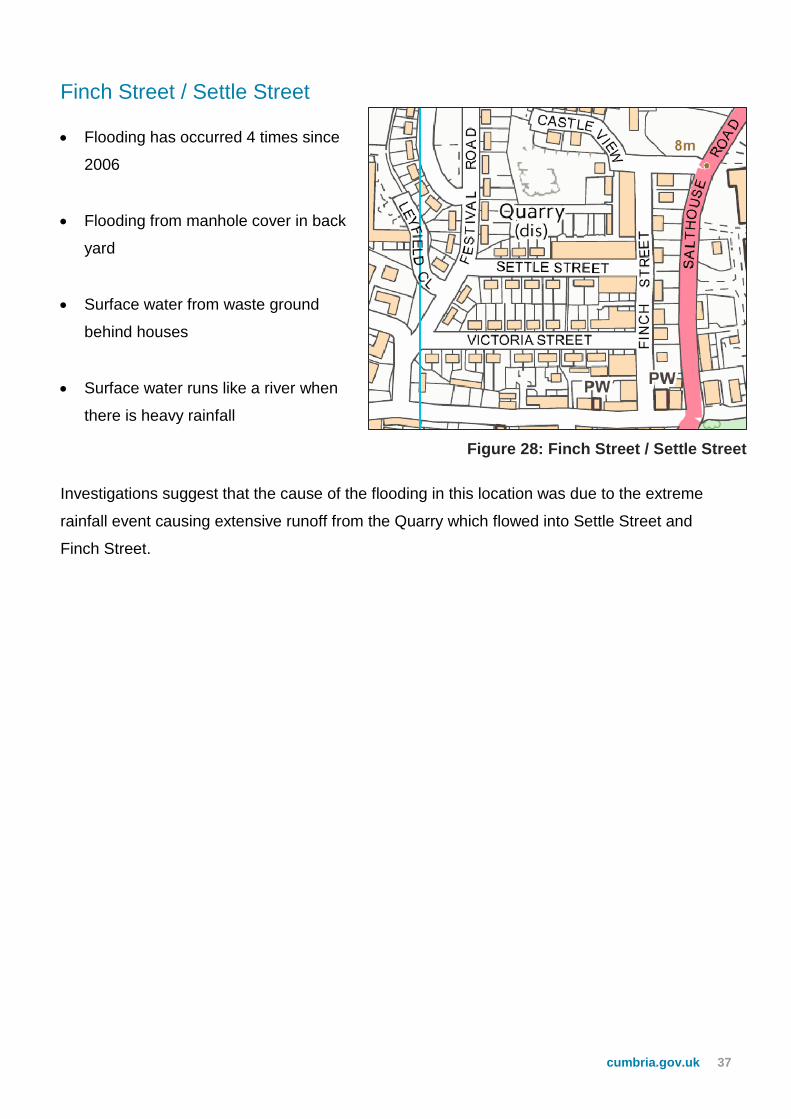
Finch Street / Settle Street
Flooding has occurred 4 times since
2006
Flooding from manhole cover in back
yard
Surface water from waste ground
behind houses
Surface water runs like a river when
there is heavy rainfall
Investigations suggest that the cause of the flooding in this location was due to the extreme
rainfall event causing extensive runoff from the Quarry which flowed into Settle Street and
Finch Street.
Figure 28: Finch Street / Settle Street
38 Serving the people of Cumbria
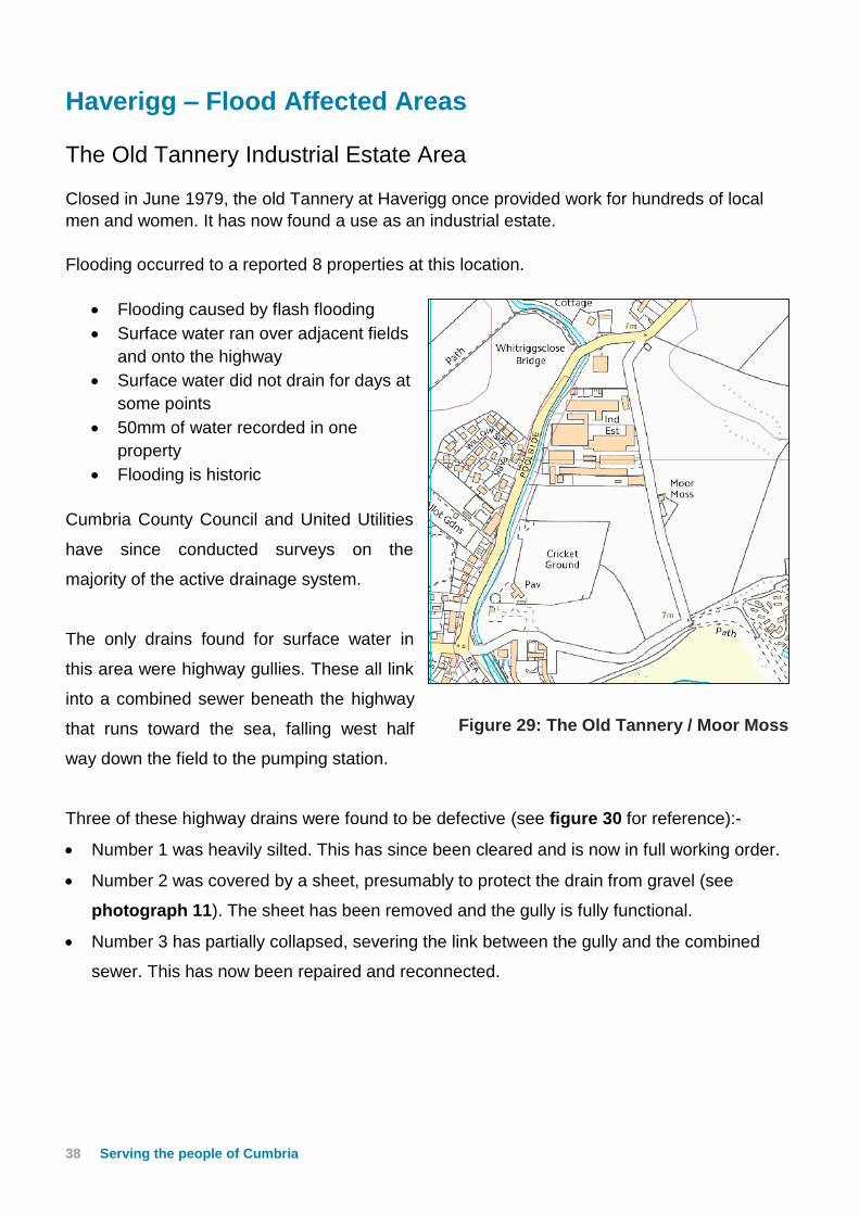
Haverigg – Flood Affected Areas
The Old Tannery Industrial Estate Area
Closed in June 1979, the old Tannery at Haverigg once provided work for hundreds of local
men and women. It has now found a use as an industrial estate.
Flooding occurred to a reported 8 properties at this location.
Flooding caused by flash flooding
Surface water ran over adjacent fields
and onto the highway
Surface water did not drain for days at
some points
50mm of water recorded in one
property
Flooding is historic
Cumbria County Council and United Utilities
have since conducted surveys on the
majority of the active drainage system.
The only drains found for surface water in
this area were highway gullies. These all link
into a combined sewer beneath the highway
that runs toward the sea, falling west half
way down the field to the pumping station.
Three of these highway drains were found to be defective (see figure 30 for reference):-
Number 1 was heavily silted. This has since been cleared and is now in full working order.
Number 2 was covered by a sheet, presumably to protect the drain from gravel (see
photograph 11). The sheet has been removed and the gully is fully functional.
Number 3 has partially collapsed, severing the link between the gully and the combined
sewer. This has now been repaired and reconnected.
Figure 29: The Old Tannery / Moor Moss

cumbria.gov.uk 39
Figure 30: Obstructed Highway Gullies
Photograph 11 (left): Standing water on collapsed chamber
Photograph 12 (right): Metal sheet over highway gully
1
2
3

40 Serving the people of Cumbria
Bank End / Sea View
One property was reported as flooded at Bank
End with an approximate depth of 60mm, this
was caused by flow from surrounding
properties and the highway.
The flooding is historic, having flooded
previously in 2012 and 2014.
It is believed that the flooding is caused due to
the properties location at low point in the land.
The only drainage we were able to locate was
the combined system, however during the
event this exceeded its design capacity and
ultimately caused flooding at the low point.
Cumbria County Council has since surveyed the highway gully systems and confirmed by dye
testing that many gullies discharge direct to the public sewer system. However, on Sea View
the highway system discharges direct to Haverigg Pool where a partial collapse had been
located and repaired.
Main Street / North Lane
Five properties were reported as internally
flooded at this point. Since the event
Cumbria county Council has conducted
surveys in and around the area in an
attempt to determine the cause. Similar to
Millom the surface water around this area
all falls into highway drains which are
subsequently linked to the combined
sewer system.
It was discovered that the highway system
is in full working order, as is the combined
sewer. It is therefore believed that the
design capacity for the system reached its
limit due to the event.
Figure 32: Main Street / North Lane
ain Street / North Lane
Approximate
location of
partial collapse
Approximate
location of the
flooding
Figure 31: Bank End area

cumbria.gov.uk 41
Likely Causes of Flooding
From the evidence gathered the most significant cause of the flooding was the extreme rainfall
event that occurred on the 30th September 2017. The rainfall was very intense over a very
short timescale with a peak rainfall of approximately 19-21mm. This is above any design
capacities of both highway drainage systems and the combined public sewer in both locations.
The anecdotal evidence from residents that the flood waters in most locations quickly
dissipated once the rainfall ceased would also suggest that systems were on the whole
working at an adequate capacity for their design.
However, investigations and surveys of drainage systems have identified some faults on the
drainage systems which have been detailed earlier within the report and these may also have
had some impact on the flooding severity.

42 Serving the people of Cumbria
Flooding History
Millom
CCC is aware of previous flooding (from the residents) as follows:–
Settle Street / Finch Street – October 2012 – internal flooding of 1 property caused by
surface water runoff from fields at the rear of the property
Mainsgate Road / Bowness Road – 4th October 2012 – several properties affected with both
internal and external flooding – surface water runoff appears to have been the cause and some
clearing of the downstream watercourse was carried out following the flooding.
Haverigg
Bank End / Sea View - Reports of previous flooding in 2012 and 2014 – Cause unknown.
The Old Tannery - There have been several instances of flooding recorded on a recurring
basis however the information of these events is limited.
In addition to the above United Utilities has also provided a plan detailing flooding incident
density within Millom and Haverigg (Figure 29).

cumbria.gov.uk 43
Figure 33: Flooding Incident Density in Millom and Haverigg

44 Serving the people of Cumbria
Recommended Actions
The following table details recommended actions for various organisations and
members of the public to consider using the Cumbria Strategic Floods Partnerships 5
Themes: Community Resilience, Upstream Management, Strengthening Defences,
Maintenance and Internal Drainage Boards (IDB’s). Some of these recommendations
may have already been carried out or are ongoing.
Cumbria
Flood
Partnership
Theme
Action by Recommended Action Timescale
Co
mm
un
ity
Re
sil
ien
ce
Cumbria Local Resilience Forum* Review and update
community plans to enable
homes and businesses to
be better prepared for
flooding and reduce the
impacts of any flooding
Ongoing
Residents and businesses To ensure where possible
reinstatement works to
properties following the
flooding allow for resilience
for any further extreme
flooding events.
Ongoing
Cumbria Planning Group,
Copeland Borough Council,
Cumbria County Council and
Environment Agency
Continue to review Local
Development Plans and
Strategic Flood risk
Assessment to reflect
current understanding of
flooding
Currently ongoing
update with JBA
consultants
Up
str
ea
m M
an
ag
em
en
t
Cumbria County Council To investigate any
opportunities to reduce the
runoff from the disused
Quarry between Settle
Street and Castle View
To be carried out
as part of the
Millom study
works when
funding has been
secured via a
funding bids to the
Regional Flood
and Coastal
Committee
Cumbria County Council / United
Utilities
To investigate opportunities
to reduce the runoff from
the footpath / New Hall
Farm into Bowness Road
As above

cumbria.gov.uk 45
Ma
inte
na
nce
United Utilities Continue with annual
sewer cleaning regime
On-going
Cumbria County Council /
Copeland Borough Council
Work to collaborate gully
cleaning and street
sweeping to coordinate
with United Utilities sewer
cleaning regime.
Ongoing
Cumbria County Council
(Electric North West)
(Network Gas)
Liaise with services to
remove cables and pipes
that have obstructed
highway drainage
systems in Mainsgate
Road
Completed
Cumbria County Council Excavate on blockage on
watercourse on
Mainsgate Road from
rear of 1970s properties
to determine extent and
condition of watercourse
to the properties behind
Mainsgate Road
Ongoing
Cumbria County Council Repair highway drainage
system at the following
locations –
Completed
Sea View,
Haverigg
Mainsgate Road,
Millom
Ongoing
Salthouse Road,
Millom
Holborn Hill
Completed /
Ongoing as
indicated
Cumbria County Council Remove flap valve at the
end of the culverted
water course into Crook
Pool
Completed
Copeland Borough Council Inspect flap valves at
Crook Pool exit / old
ironworks
Ongoing
Cumbria County Council/United
Utilities
Investigate replacement
drain system at Bank End
Haverigg
Completed

46 Serving the people of Cumbria
Str
en
gth
en
ing
Defe
nc
es
United Utilities / Cumbria County
Council
Review network capacity
of drainage systems and
consider where
improvements can be
made.
Some review of
public sewer
system has been
carried out. Further
review to be carried
out as part of the
Millom study works
when funding has
been secured via a
funding bids to the
Regional Flood and
Coastal Committee
Cumbria County Council Review effect of the
Crook Pool watercourse
access crossings on the
drainage outfall from
Mainsgate Road
Level survey
completed. Further
review to be carried
out as part of the
Millom study works
when funding has
been secured via a
funding bids to the
Regional Flood and
Coastal Committee
Cumbria County Council/United
Utilities
Review highway drainage
system at Old Tannery,
Haverigg
Initial investigations
complete. Further
review to be carried
out as part of the
Millom study works
when funding has
been secured via a
funding bids to the
Regional Flood and
Coastal Committee
Cumbria County Council/United
Utilities
Investigate areas where
surface water can be
drained separately from
the current combined
system e.g. Holborn Hill,
Market St, Albert St etc.
Further review to be
carried out as part
of the Millom study
works when funding
has been secured
via a funding bids to
the Regional Flood
and Coastal
Committee
* The Cumbria Local Resilience Forum includes emergency services, local authorities,
Cumbria County Council, Environment Agency, Maritime Coastguard Agency and health
agencies along with voluntary and private agencies. Under the Civil Contingencies Act (2004)
every part of the United Kingdom is required to establish a resilience forum.

cumbria.gov.uk 47
Next Steps – Community & Catchment Action Plan
The Cumbria Floods Partnership has brought together a wide range of community representatives and
stakeholders from a variety of sectors to plan and take action to reduce flood risk. The Cumbria Floods
Partnership, led by the Environment Agency, is producing a 25 year flood action plan for the Cumbrian
catchments worst affected by the December 2015 flooding, including Carlisle. The plan will consider
options to reduce flood risk across the whole length of a river catchment including upstream land
management, strengthening flood defences, reviewing maintenance of banks and channels,
considering water level management boards and increasing property resilience. The Cumbria Floods
Partnership structure below is now a reality working across Cumbria.
The diagrams below helps demonstrate how the two partnerships have now come together:

48 Serving the people of Cumbria
Communities working together across Cumbria
Appendices
Appendix 1 Glossary
Appendix 2 Summary of Relevant Legislation and Flood
Risk Management Authorities
Appendix 3 UU Historic Works/Routine Maintenance/
Pumping Station Operation
Appendix 4 LLFA Investigations
Appendix 5 Environment Agency
Appendix 6 Network Rail
Appendix 7 Feedback from Residents and draft report
Appendix 8 Useful contacts and links

Cumbria County Council
50 Serving the people of Cumbria
Appendix 1: Glossary Acronyms EA Environment Agency CCC Cumbria County Council UU United Utilities LLFA Lead Local Flood Authority LFRM Local Flood Risk Management MSfWG Making Space for Water Group FAG Flood Action Group FWMA Flood and Water Management Act 2010 LDA Land Drainage Act 1991 WRA Water Resources Act 1991

cumbria.gov.uk 51
Appendix 2: Summary of Relevant Legislation and Flood
Risk Management Authorities
The Flood Risk Regulations 1999 and the Flood and Water Management Act 2010 (the Act) have established Cumbria County Council (CCC) as the Lead Local Flood Authority (LLFA) for Cumbria. This has placed various responsibilities on CCC including Section 19 of the Act which states: Section 19 (1) On becoming aware of a flood in its area, a lead local flood authority must, to the extent
that it considers it necessary or appropriate, investigate— (a) which risk management authorities have relevant flood risk management functions,
and (b) whether each of those risk management authorities has exercised, or is proposing to
exercise, those functions in response to the flood. (2) Where an authority carries out an investigation under subsection (1) it must—
(a) publish the results of its investigation, and (b) notify any relevant risk management authorities.
A ‘Risk Management Authority’ (RMA) means:
(a) the Environment Agency, (b) a lead local flood authority, (c) a district council for an area for which there is no unitary authority, (d) an internal drainage board, (e) a water company, and (f) a highway authority.
The table below summarises the relevant Risk Management Authority and details the various local source of flooding that they will take a lead on.
Flood Source
Environment Agency
Lead Local Flood Authority
District Council
Water Company
Highway Authority
RIVERS
Main river
Ordinary watercourse
SURFACE RUNOFF
Surface water
Surface water on the highway
OTHER
Sewer flooding
The sea
Groundwater
Reservoirs

Cumbria County Council
52 Serving the people of Cumbria
The following information provides a summary of each Risk Management Authority’s roles and responsibilities in relation to flood reporting and investigation. Government – Defra develop national policies to form the basis of the Environment Agency’s and Cumbria County Council’s work relating to flood risk. Environment Agency has a strategic overview of all sources of flooding and coastal erosion as defined in the Act. As part of its role concerning flood investigations this requires providing evidence and advice to support other risk management authorities. The EA also collates and reviews assessments, maps and plans for local flood risk management (normally undertaken by LLFA). Lead Local Flood Authorities (LLFAs) – Cumbria County Council is the LLFA for Cumbria. Part of their role requires them to investigate significant local flooding incidents and publish the results of such investigations. LLFAs have a duty to determine which risk management authority has relevant powers to investigate flood incidents to help understand how they happened, and whether those authorities have or intend to exercise their powers. LLFAs work in partnership with communities and flood risk management authorities to maximise knowledge of flood risk to all involved. This function is carried out at CCC by the Local Flood Risk Management Team. District and Borough Councils – These organisations perform a significant amount of work relating to flood risk management including providing advice to communities and gathering information on flooding. Water and Sewerage Companies manage the risk of flooding to water supply and sewerage facilities and the risk to others from the failure of their infrastructure. They make sure their systems have the appropriate level of resilience to flooding and where frequent and severe flooding occurs they are required to address this through their capital investment plans. It should also be noted that following the Transfer of Private Sewers Regulations 2011 water and sewerage companies are responsible for a larger number of sewers than prior to the regulation. Highway Authorities have the lead responsibility for providing and managing highway drainage and certain roadside ditches that they have created under the Highways Act 1980. The owners of land adjoining a highway also have a common-law duty to maintain ditches to prevent them causing a nuisance to road users. Flood risk in Cumbria is managed through the Making Space for Water process which involves the cooperation and regular meeting of the Environment Agency, United Utilities, District/Borough Councils and CCC’s Highway and LFRM Teams to develop processes and schemes to minimise flood risk. Where minor works or quick win schemes can be identified, these will be prioritised and subject to available funding and resources will be carried out as soon as possible. Any major works requiring capital investment will be considered through the Environment Agency’s Medium Term Plan or a partners own capital investment process. Flood Action Groups are usually formed by local residents who wish to work together to resolve flooding in their area. The FAGs are often supported by either CCC or the EA and provide a useful mechanism for residents to forward information to the MSfWG.
cumbria.gov.uk 53
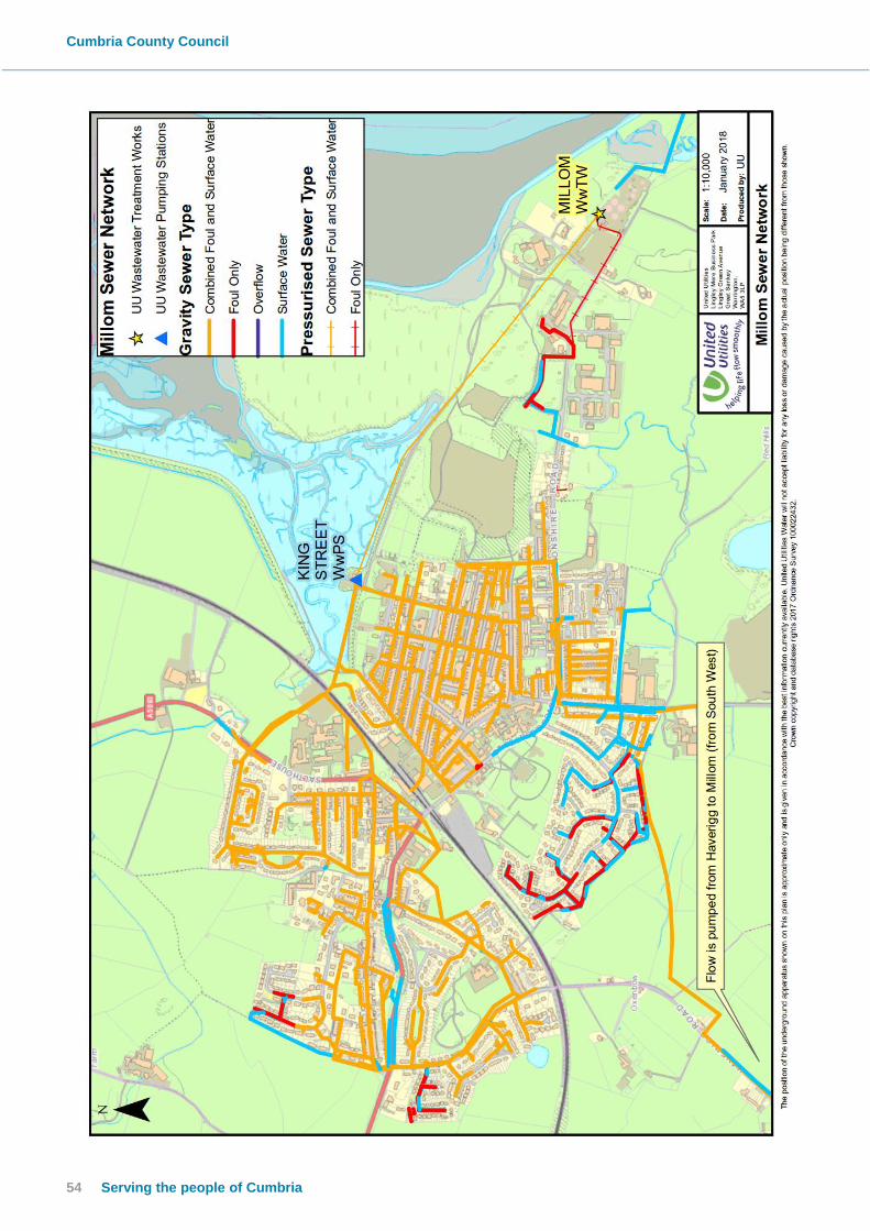
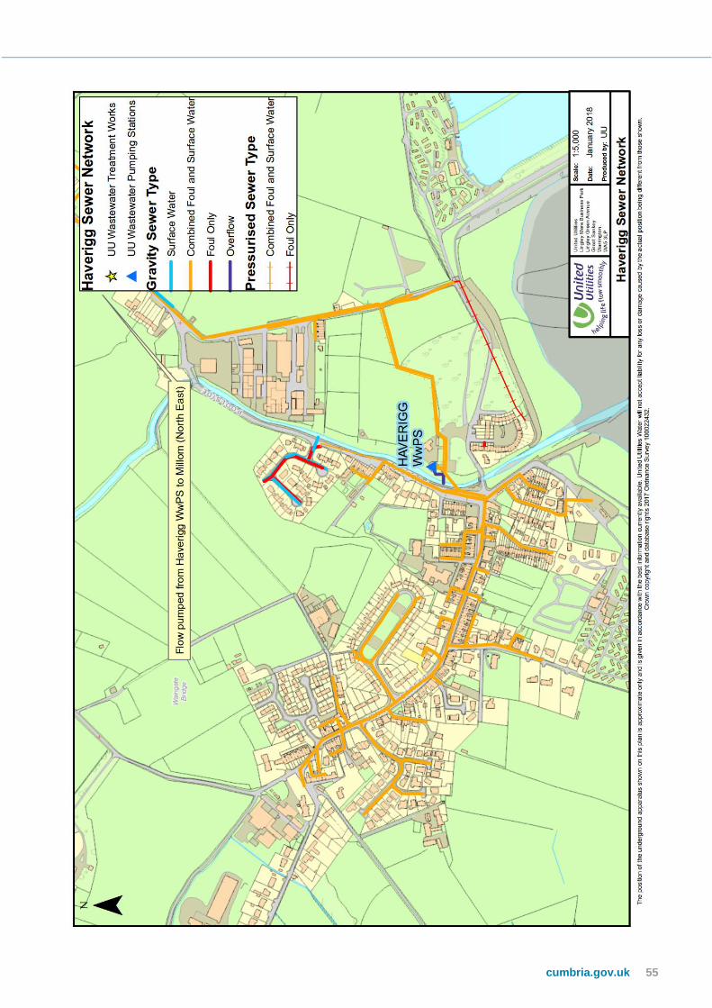
Appendix 3: UU Historic Works/Routine Maintenance/
Pumping Station Operation
The following plans detail the sewer network within Millom and Haverigg.
Cumbria County Council
54 Serving the people of Cumbria
cumbria.gov.uk 55

Cumbria County Council
56 Serving the people of Cumbria
Desilting Programme
United Utilities have provided the following information on their planned desilting works:
• The planned cleaning programme covers the areas of Millom where we have issues
with silt in the sewer due to poor gradient.
• The sites/manholes included are mostly in and around the town centre.
• This programme is carried out annually prior to the start of winter.
• The programme is reviewed following its conclusion to identify if there is a need to
increase the frequency of cleaning. This is done through our liaison with a UU
representative known as the area Strategic work planner (SWP) who plans the work and
to ensure it’s carried out.
• The programme ensures the sewers are at maximum capacity before winter
commences (with typically more persistent rainfall periods).
Pumping Stations and Treatment works
Millom WwTW Storm Overflow/King Street Pumping Station (COP0049) AMP5 Unsatisfactory Intermittent Discharge (UID) Project
In AMP3 (2000-2005) storm discharges from two overflows within the Millom catchment, WwTW storm tanks overflow and King Street Pumping Station storm overflow, were designated as unsatisfactory, impacting on the Duddon Channel, as a result of bathing water/shellfish and aesthetic criteria.
A project was to meet the design criteria of 3 spills per bathing season for bathing waters and 10 spills per annum or equivalent for shellfish requirements. The aesthetic criteria was met by designing screens to 6mm in two directions to screen flows up to a 1 in 5 year event.
The purpose for this project was not related to flood protection. However it had to demonstrate ‘no detriment’ to the existing levels of service in the network upstream.

cumbria.gov.uk 57
King Street Pumping Station
The proposed solution for King Street pumping station was based on upgrading and reconfiguring the existing pumping station and laying an additional rising main to Millom WwTW.
The scheme involved the delivery of:
Up-grade to existing pumps to increase the pass forward flows up to a peak of 700 l/s to the WwTW.
A new 500mm dia. rising main laid parallel to the existing rising main.
New storm overflow screen to ensure all spills up to a 1 in 5 year design event are screened to 6mm in two directions.
The existing high level overflow was retained to protect the station from tidal ingress while affording a relief in the event of an emergency.
The operation of the pumping station with the four interconnecting wet wells and the three storm pumps, operating in duty/assist/standby mode remain the same.
Millom WwTW Storm Tanks
The proposed solution for Millom WwTW storm tanks was based on increasing the Flow to Full Treatment (FTFT) from 61 l/s to 100 l/s and providing Ultra-Violet treatment to all storm spills discharged when the existing storm tanks are full. Storm Tank no.1 acts as blind tank capturing the first flush of the storm, which is returned for treatment. There is no overflow to the Duddon Channel from this tank. When the blind tank is full (Storm Tank no.1), storm flows back-up in Storm Tank no.2, then weir over and spill to the Storm UV plant for treatment. The Storm UV treatment achieves a 2 log reduction in bacteria across the overflow. This treatment is equivalent to a reduction in spill frequency to less than 10x per annum.
The scheme was to provide the delivery of:
Refurbishment of the existing inlet screens and increasing screening capacity from 305 l/s to 700 l/s; providing 6mm screening in two directions.
Modification to storm tank overflow to feed the new Storm UV plant; existing Storm Storage 1,850m3.
New Storm UV plant to accommodate for flows over 100 l/s when the existing storm tanks are full, up to a maximum 600 l/s.
Refurbishment work and new process units was provided to accommodate the increase in FTFT from 61 l/s to 100 l/s. This included:
Refurbishment of Primary Settlement Tank
New secondary SAF plant
New Final Humus tank
New Final effluent UV plant
New Tidal pumping station for storm outfall
New WwTW and Storm Outfall pipeline at a new location

Kin
g S
tree
t P
um
pin
g S
tati
on
Op
era
tio
n D
uri
ng
Eve
nt


Cumbria County Council
60 Serving the people of Cumbria
Haverigg Pumping Station
Haverigg Waste water pumping station is a combined sewer waste water network
pumping station that directs all flows to the Millom wastewater network system
Site has a pass forward flow in the permit of 43.5 L/S
The tank has 950 cubic meters of storage
Permitted discharges are via a 750mm pipe to Haverigg pool, NATIONAL GRID
REFERENCE SD 1608 7876 spill through a 6mm static Copa wave screen
Site is a wet well submersible site with a Duty/ Standby auto rotation
Sewer layout
To Millom

cumbria.gov.uk 61

Cumbria County Council
62 Serving the people of Cumbria
Haverigg pumping station wet well level 30th September 2017
Summary of Telemetry Data 30th September 2017
• 07:16 Pump no 2 starts running
• 07:32 Wet well from normal to high
• 08:54 Wet well goes from high to high high
• 09:04 Wet well reaches back up pump control so pump 2 stops and pump 1 starts
• 09:10 CSO Starts to spill into watercourse
• 10:33 Pump no 1 trips and Pump no 2 starts running right away
• 14:16 Pump no 1 is reset by controller and starts running right away and Pump no 2
stops
On the 30th of September 2017 the catchment received a large amount of rainfall causing high
flows into the site wet well. During the day the well level rose dramatically causing pumps on
site to run continually for over 40 hours. The site was spilling as permitted to do so for 30 hours
stopping the local network from flooding. The site was monitored for any issues by the ICC that
were passed within the correct timeframes and managed.
Other Works of Note
LLFA records mentions a UU scheme to upsize the sewers in Finch Street to reduce the risk of
flooding to properties in the Finch St / Settle St area that was completed around 2012/13.

cumbria.gov.uk 63
0
0.5
1
1.5
2
2.5
3
3.5
4
Watercourse Levels
Level
Inlet 1
Outfall
Diff 1.14 m
Appendix 4: LLFA Investigations Crook Pool watercourse assessment
Graph of Crook Pool Levels from Outfall of surface water systems to sea
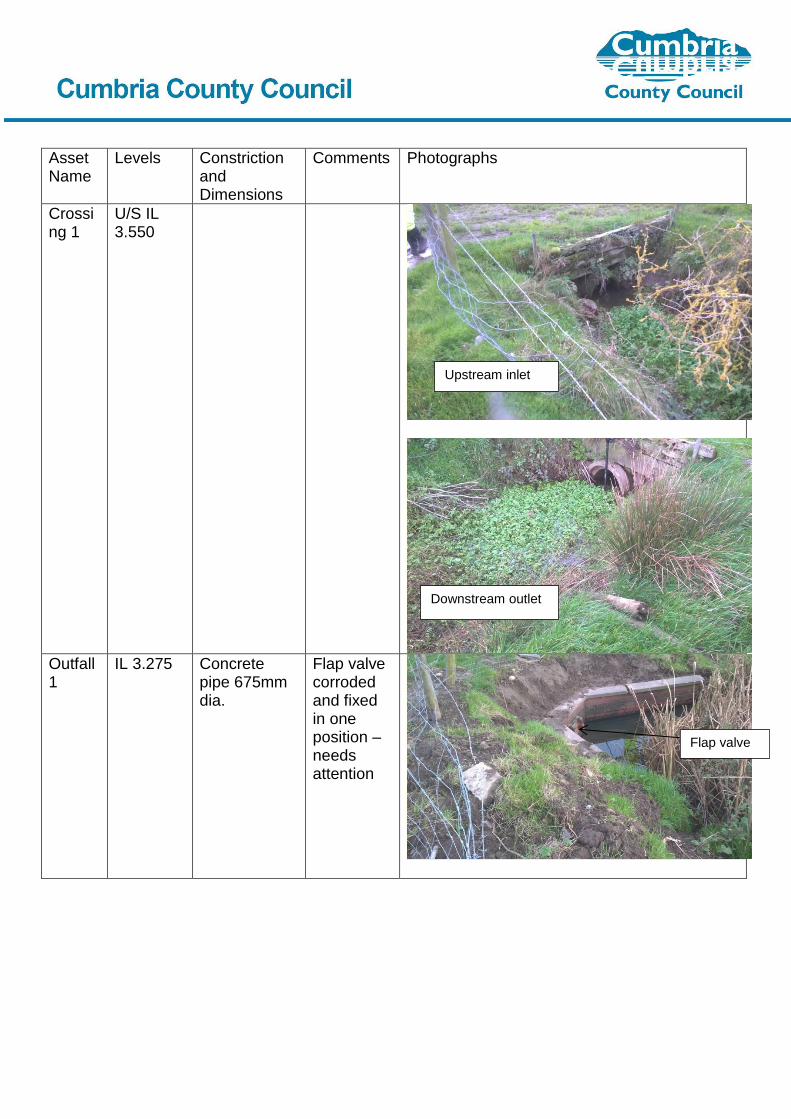
Asset Name
Levels Constriction and Dimensions
Comments Photographs
Crossing 1
U/S IL 3.550
Outfall 1
IL 3.275
Concrete pipe 675mm dia.
Flap valve corroded and fixed in one position – needs attention
Upstream inlet
Downstream outlet
Flap valve

cumbria.gov.uk 65
Crossing 2
U/S IL 3.351 D/S IL 3.362
Concrete pipe 1100mm dia.
Crossing 3
U/S IL 3.209 D/S IL 3.485
U/S Stone culvert 950mm high x 850mm wide D/S concrete pipe 1000mm dia.
Position of change of construction unknown
Upstream
inlet
Downstream
outlet
Upstream inlet
Reeds in
watercourse
next to outfall

Cumbria County Council
66 Serving the people of Cumbria
Crossing 4
U/S IL 3.024 D/S IL 3.217
Stone culvert U/S 800mm high x 800mm wide D/S 800mm high x 550mm wide
Crossing 5
U/S IL 2.859 D/S IL 2.837
Stone culvert U/S 600mm high x 950mm wide D/S 650mm high x 550mm wide
Minor collapse at side of culvert – preliminary discussion with landowner regarding repair during inspection
Crossing 6
U/S IL 2.478 D/S IL 2.184
Stone culvert U/S 850mm high x 850mm wide D/S 900mm high x 800mm wide
Crossing 7
U/S IL 2.264 D/S IL 2.134
Stone culvert U/S 1100mm high x 1000mm wide D/S 1200mm high x 900mm wide
Upstream
inlet
Upstream inlet
Downstream
outlet

cumbria.gov.uk 67
Inlet 1 IL 2.212 (this is approximate as it was not possible to access the invert due to the grid)
Concrete pipe with sluice gate and grid Inlet approach 2000mm wide culvert approx. 1300mm dia but unable to measure accurately
Outfall 2
IL 1.023
Concrete pipe 1500mm
Inlet 2 IL 1.113
Concrete pipe 1700mm dia
Some stones at entrance – would benefit from removal
Inlet behind
trash screen

Cumbria County Council
68 Serving the people of Cumbria
Outfall 3
IL 0.671
Concrete pipe 1550mm dia.

cumbria.gov.uk 69
Damaged Highway Drainage Assets
Damaged Highway Drainage in Mainsgate Road by ENW cabling work from no 1 to 63

Cumbria County Council
70 Serving the people of Cumbria
Damaged Highway Drainage in Mainsgate Road by ENW cabling work next to CPG Factory
cumbria.gov.uk 71
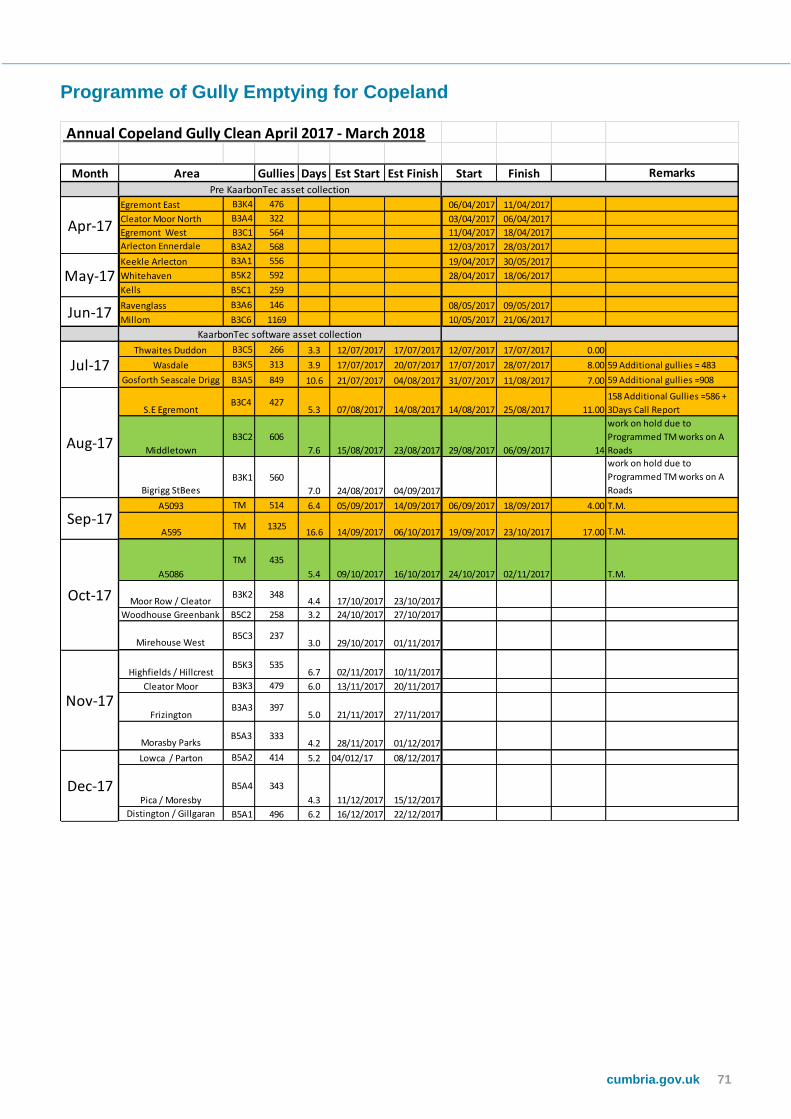
Programme of Gully Emptying for Copeland
Annual Copeland Gully Clean April 2017 - March 2018
Month Gullies Days Est Start Est Finish Start Finish Remarks
Egremont East B3K4 476 06/04/2017 11/04/2017
Cleator Moor North B3A4 322 03/04/2017 06/04/2017
Egremont West B3C1 564 11/04/2017 18/04/2017
Arlecton Ennerdale B3A2 568 12/03/2017 28/03/2017
Keekle Arlecton B3A1 556 19/04/2017 30/05/2017
Whitehaven B5K2 592 28/04/2017 18/06/2017
Kells B5C1 259
Ravenglass B3A6 146 08/05/2017 09/05/2017
Millom B3C6 1169 10/05/2017 21/06/2017
Thwaites Duddon B3C5 266 3.3 12/07/2017 17/07/2017 12/07/2017 17/07/2017 0.00
Wasdale B3K5 313 3.9 17/07/2017 20/07/2017 17/07/2017 28/07/2017 8.00 59 Additional gullies = 483
Gosforth Seascale Drigg B3A5 849 10.6 21/07/2017 04/08/2017 31/07/2017 11/08/2017 7.00 59 Additional gullies =908
S.E Egremont B3C4 427
5.3 07/08/2017 14/08/2017 14/08/2017 25/08/2017 11.00
158 Additional Gullies =586 +
3Days Call Report
Middletown
B3C2 606
7.6 15/08/2017 23/08/2017 29/08/2017 06/09/2017 14
work on hold due to
Programmed TM works on A
Roads
Bigrigg StBees
B3K1 560
7.0 24/08/2017 04/09/2017
work on hold due to
Programmed TM works on A
Roads
A5093 TM 514 6.4 05/09/2017 14/09/2017 06/09/2017 18/09/2017 4.00 T.M.
A595TM 1325
16.6 14/09/2017 06/10/2017 19/09/2017 23/10/2017 17.00 T.M.
A5086
TM 435
5.4 09/10/2017 16/10/2017 24/10/2017 02/11/2017 T.M.
Moor Row / Cleator B3K2 348
4.4 17/10/2017 23/10/2017
Woodhouse Greenbank B5C2 258 3.2 24/10/2017 27/10/2017
Mirehouse West B5C3 237
3.0 29/10/2017 01/11/2017
Highfields / Hillcrest B5K3 535
6.7 02/11/2017 10/11/2017
Cleator Moor B3K3 479 6.0 13/11/2017 20/11/2017
Frizington B3A3 397
5.0 21/11/2017 27/11/2017
Morasby Parks B5A3 333
4.2 28/11/2017 01/12/2017
Lowca / Parton B5A2 414 5.2 04/012/17 08/12/2017
Pica / Moresby
B5A4 343
4.3 11/12/2017 15/12/2017
Distington / Gillgaran B5A1 496 6.2 16/12/2017 22/12/2017
Area
Aug-17
Sep-17
Oct-17
Nov-17
Jul-17
Apr-17
May-17
Jun-17KaarbonTec software asset collection
Pre KaarbonTec asset collection
Dec-17

Cumbria County Council
72 Serving the people of Cumbria
Surveyed Highway Drainage Assets, including piped watercourses
Ordinary
Watercourse
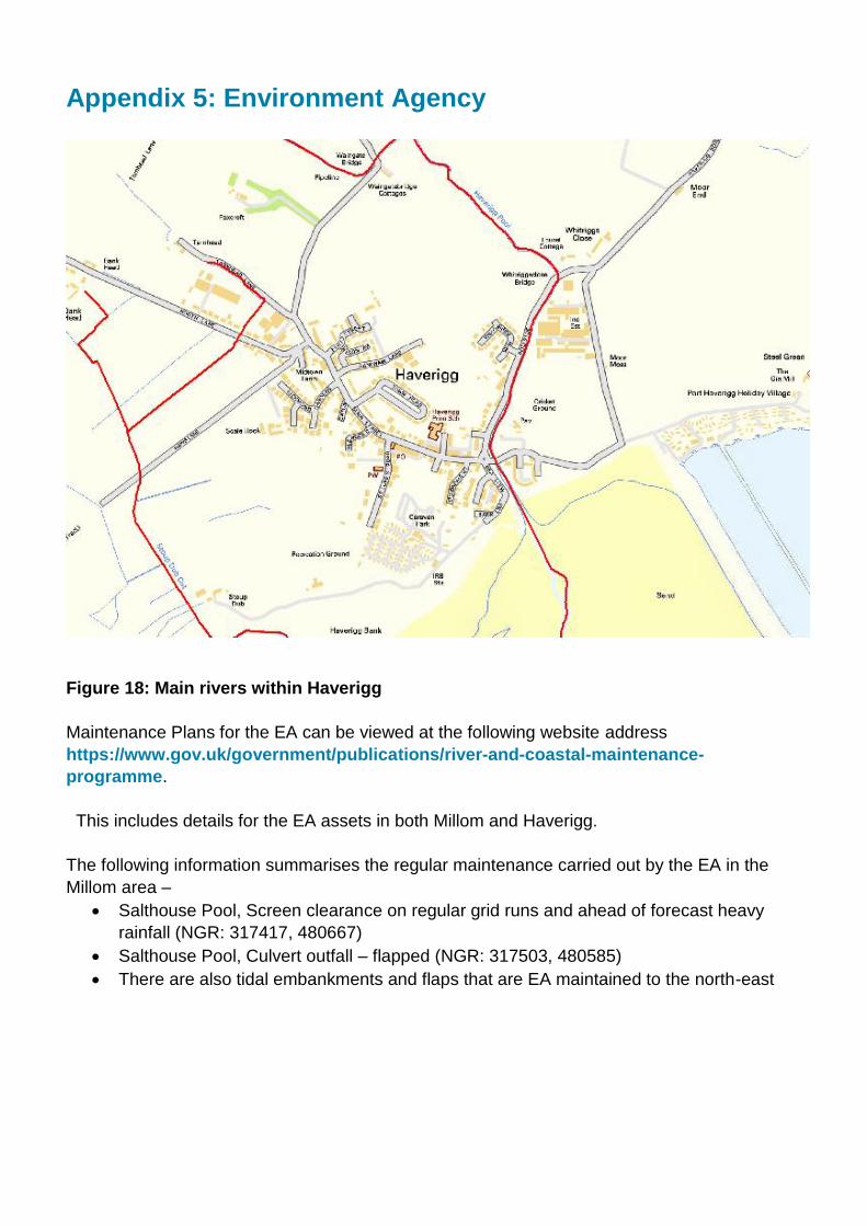
Appendix 5: Environment Agency
Figure 18: Main rivers within Haverigg
Maintenance Plans for the EA can be viewed at the following website address
https://www.gov.uk/government/publications/river-and-coastal-maintenance-
programme.
This includes details for the EA assets in both Millom and Haverigg.
The following information summarises the regular maintenance carried out by the EA in the
Millom area –
Salthouse Pool, Screen clearance on regular grid runs and ahead of forecast heavy
rainfall (NGR: 317417, 480667)
Salthouse Pool, Culvert outfall – flapped (NGR: 317503, 480585)
There are also tidal embankments and flaps that are EA maintained to the north-east

74 Serving the people of Cumbria
Figure 19: Assets maintained by EA in Millom
In Haverigg the EA maintain the following assets –
Stoup Dub Cut, Haverigg Bank, screen clearance on regular grid runs and ahead of
forecast heavy rainfall (NGR: 315548, 478204)
Haverigg Pool, right bank upstream of Whitriggsclose Bridge, raised embankment
(NGR: 316194, 479226)
Haverigg Pool, Raised Floodwalls both banks and tidal flap valves, from Whitriggsclose
Bridge to Harbour Hotel Bridge
Haverigg Pool, Raised Floodwalls right bank and tidal flap valves, along Sea View
Figure 20: Assets maintained by EA in Haverigg

It is considered that the EA assets performed well during the event and there have not been any reports of any back flow from the sea side of the defences during the event. It is therefore considered that the main rivers within both the Millom and Haverigg catchments did not have an impact on the flood event.
76 Serving the people of Cumbria
Appendix 6: Network Rail
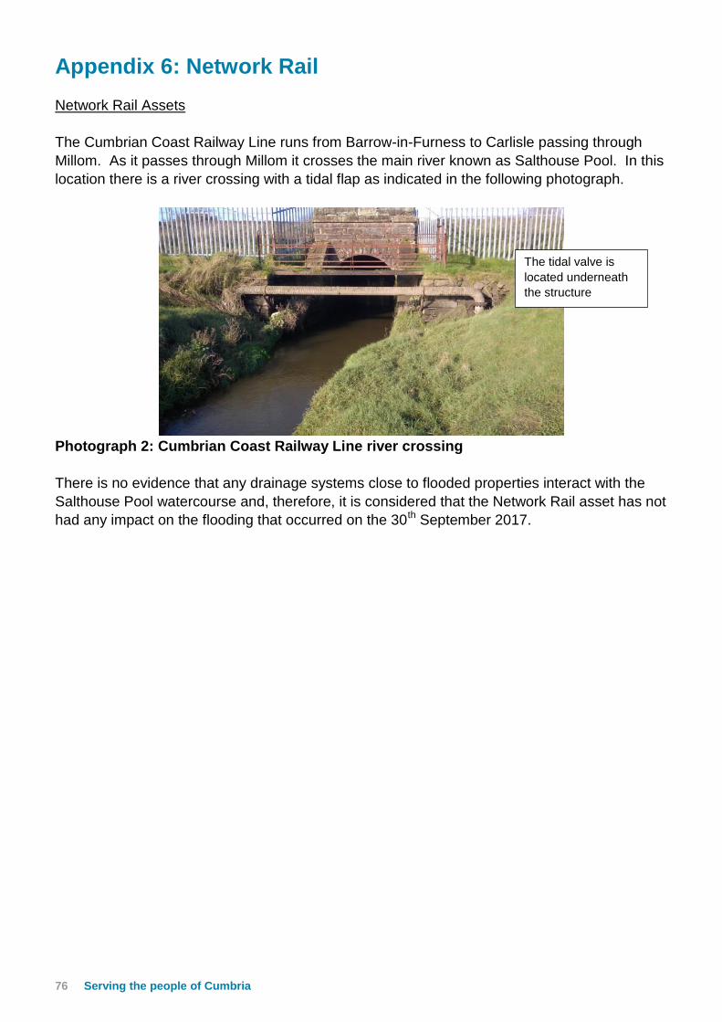
Network Rail Assets
The Cumbrian Coast Railway Line runs from Barrow-in-Furness to Carlisle passing through
Millom. As it passes through Millom it crosses the main river known as Salthouse Pool. In this
location there is a river crossing with a tidal flap as indicated in the following photograph.
Photograph 2: Cumbrian Coast Railway Line river crossing
There is no evidence that any drainage systems close to flooded properties interact with the
Salthouse Pool watercourse and, therefore, it is considered that the Network Rail asset has not
had any impact on the flooding that occurred on the 30th September 2017.
The tidal valve is
located underneath
the structure

Appendix 7: Feedback from Residents and draft report
The following comments were received from residents after the information gathering flood
forum on 12th October 2017:-
Mainsgate Road / Bowness Road / Cumberland Close / Lowther Road
Surface water often collects on the highway in front of 1 & 3 Bowness Road and this
build-up of water was one of the sources of the flooding. This is often an issue during
heavy rainfall.
How often is the drainage system maintained and cleaned
How has an electricity cable been allowed to run through a surface water drain
When was the road last swept
Were the pumps working and can details of this be included in the report
Footway at the rear of Bowness Road used to be a watercourse but has become filled
up over the years
Water started to recede about 13:30 with manhole Bowness Road / Mainsgate Road
was draining and making loud noises
Surface water was running off from the field behind Bowness Road
Drains surcharging including toilet backing up
Mainsgate Road – toilet slow to flush at 08:45 with surcharging from manhole in the
garden about 09:30
Surrey Street / Oxford Street / Richmond Street / Wasdale Road
Heavy downpour approximately 09:50
Back street flooded about 09:30 with water gone by 12:30
Water went down really fast in approx. 1 hour
Water entered both back and front for some with surcharging from combined manhole
Rainfall exceeded drain capacity and surcharging from toilet
Lonsdale Road / Market Street / Albert Street / Newton Street etc. area
Some flooding from surcharged drain in back lane of Lonsdale Road
Flooding began about 10:00 and started to abate between 11:30 – 13:00
Water was to front step on one property but flooding in from the back
Gully in back lane covered with soil and weeds

78 Serving the people of Cumbria
Who is responsible for cleaning back lanes
Heavy rainfall from 06:00
Rainwater on roof looked like a river
Flooding from back and front in Market Street
Some of the back lanes appear to be sinking – could this cause a problem
Earl Street drainage also seemed to impact on the flooding in Market Street
Were the pumps working
Flooding also increased by cars driving through the flood water
Problem with parked cars when gully cleaning
Leaves and general debris blocking gullies
How are watercourses managed – never seen any clearing or dredging
Pannatt Hill
Drains backed up and house flooded at approx. 09:50 then disappeared 13:00
Drains on the footpath to the rear of no’s 43-45 etc. are blocked
Holborn Hill / Victoria Street
Flooding caused by flash flooding
Previous flooding in October 2006 and October 2010
Surface water noticed running down Festival Road
Surface water runs past drains
Often bus company park over drains so notification required before cleaning of gullies
Surface water rushed down footway between Victoria Street and Holborn Hill
The following table details comments received by Cumbria County Council
Comments Cumbria County Council response
Appears to be lack of gully maintenance At the draft report meeting Doug Coyle of
Cumbria County Council accepted that
Cumbria County Council could do more to
ensure the gullies were more consistently
cleaned and explained that new systems
(Kaarbontech) were being introduced to
enable to carry out maintenance in a more
efficient way. Also in future there would be
better collaboration between United Utilities
and Cumbria County Council to ensure a
more consistent cleaning approach to both
gullies and sewers.
Concerns were raised regarding the rainfall
recorded at Lanthwaite rain gauge and the
flooding that occurred
Further investigations have been carried out
and additional information has been obtained
regarding the rainfall event – this has been
updated within the report.

Appendix 8: Useful contacts and links
Cumbria County Council (Local Flood Risk Management):
[email protected], www.cumbria.gov.uk, tel: 01228 221330
Cumbria County Council (Highways):
www.cumbria.gov.uk/highways-pavements/reporting-problem-on-a-highway/
or contact the Highways Hotline on 0300 303 2992
Out of hours emergencies should be reported via the Police on 101
United Utilities: www.unitedutilities.com, tel: 0845 746 2200
Copeland Borough Council’s Building Control team can offer assistance to Millom
residents affected by flooding that are concerned about the condition of their property.
Assistance can be sought by uninsured residents who believe their property may have been
damaged as a result of flood water entering or laying underneath properties (in basements
etc.). If you are a home owner, don’t have buildings insurance and would like expert advice
around the structural condition of your property, contact the Building Control team on
Flood Re
We're also aware that some people are finding it difficult to get insurance that covers flooding,
or are facing large increases in premiums when their policies come up for renewal.
It's worth taking a look at Flood Re, a national scheme established in the last couple of years to
ensure people living in flood risk areas have access to affordable home insurance:
https://www.floodre.co.uk/Recycled furniture – information can be found here
http://www.recycleforcumbria.org/recycling/reuseorganisations.asp
Lancaster University have resources on flooding and children, that do a good job of
explaining what the impacts are on children although this is more aimed at staff/professionals
than families:
http://wp.lancs.ac.uk/cyp-floodrecovery/
And page of reports/resources:
http://wp.lancs.ac.uk/cyp-floodrecovery/what-weve-produced/
The Flood Advisory Service provide a step by step guide for homeowners to help them to
understand their flood risk and advise how to make homes more resilient. There will be copies
available in Millom library from Monday or those people who don’t have access to the internet.
This is the link to the webpage Managing your Flood Risk
Grant support available for flood affected households: Individuals and families affected by the recent flooding in Millom and South Cumbria are
eligible to apply for financial support from Cumbria Community Foundation’s Cumbria Disaster
Fund; priority will be given to uninsured households with low income. More details are available
on the CCF website: https://www.cumbriafoundation.org/fund/cumbria-disaster-relief-
fund/
Advice Re: Cleaning & Salvaging Flood Damaged Items:

80 Serving the people of Cumbria
‘Protecting Precious Memories Toolkit’- developed by York Archaeological Trust it give advice
on cleaning & salvaging objects. It is available here
http://www.cumbria.gov.uk/emergencyplanning/supportingpages/floodingadvice.asp
Flood and Water Management Act 2010:
http://www.legislation.gov.uk/ukpga/2010/29/contents
Water Resources Act 1991:
http://www.legislation.gov.uk/all?title=water%20resources%20act
Land Drainage Act:
http://www.legislation.gov.uk/all?title=land%20drainage%20act
Highways Act 1980:
http://www.legislation.gov.uk/all?title=highways%20act
EA – ‘Living on the Edge’ a guide to the rights and responsibilities of riverside occupation:
http://www.environment-agency.gov.uk/homeandleisure/floods/31626.aspx
EA – ‘Prepare your property for flooding’ how to reduce flood damage including flood
protection products and services:
http://www.environment-agency.gov.uk/homeandleisure/floods/31644.aspx

82 Serving the people of Cumbria
cumbria.gov.uk