15. Dunnerdale and Broughton Low Fells - cumbria.gov.uk · 15. Dunnerdale and Broughton Low Fells...
69
A Guide to the Cumbria Historic Landscape Characterisation Programme Version 1 July 2009 57 15. Dunnerdale and Broughton Low Fells Bounded by Coniston Water to the east, and the Central Fells to the north and west, this character area is bisected by the Lake District National Park boundary. It is dominated by the valley running from the Duddon estuary up to Coniston Water, with Coniston village at the north end and the market village of Broughton-in-Furness at the centre and the industrial town of Millom at the south. The topographical context of the character area is the same either side of the park boundary and all the area shares a similar history of woodland industries and minerals extraction and processing. The valleys were important communications routes for the slate and metal ore extractive industries around Coniston, Torver and the Langdale Valleys. Past industries including medieval iron smelting, post-medieval copper mining, 18 th - 20 th century textiles manufacture and 19 th and 20 th century iron works have all left their mark and are a major characteristic of the area. The western part of the character area, outside the park, experienced more development from the later 19 th century, however, especially at Millom. The exclusion of the southern part of the character area from the park has exacerbated difference in recent years with a concentration of quarrying and the development of wind farms as on Kirkby Moor. Like the Allithwaite and Underbarrow Low Fells, this area is characterised by low hills that were previously common waste and which were subject to planned enclosure in the late 18 th and 19 th centuries. Like the Furness Fells, this was an area of woodland industry, and the ancient woodland produced coppiced wood for craft industries such as the making of swill baskets and tool handles. Whilst there are areas of ancient woodland running along the valley sides of the Duddon and significant blocks of coniferous plantation woodland, often in areas of planned enclosure, the area is nothing like as well wooded as the neighbouring Furness Fells character area. The eastern half of the area is dominated by open low fell, farmed in common and now largely infested with bracken. Settlement is largely restricted to the valleys, and aside from the large nucleations at Broughton, Coniston and Millom, is mainly dispersed in nature consisting of discrete settlements and small nucleations. Some small nucleations developed as industrial hamlets in the post-medieval period as at Hallthwaites and the Hill. Settlements are surrounded by ancient enclosures and there is little evidence of former arable common fields. The former medieval deer park to Millom Castle remains a recognisable feature. Legacy: A mixed pattern of modern and older settlements and field enclosure with strong legibility of landscape elements of medieval origin, strong survival of pre-19 th century industrial features. Landscape designation and status: Northern portion of area within the Lake District National Park. Planning authorities: LDNPA, Barrow Borough Council, Copeland Borough Council and South Lakeland District Council. 16. Eastern Lake District Fells The Eastern Fells lie largely within the Lake District National Park, to the north of the Crosthwaite and Underbarrow Low Fells and the Windermere, and the Rothay and Brathay Valleys. The park boundary forms the south-eastern edge of the character area, though a tongue extends south-eastwards out of the park encompassing Birkbeck, Bretherdale and Whinfell commons. The character is defined by expanses of post medieval enclosures, both intakes and 19 th century planned enclosures which extend onto the high moorland. The enclosures are large, and irregular in shape, defined mainly by topography, and in many places enclosure boundaries have not
Transcript of 15. Dunnerdale and Broughton Low Fells - cumbria.gov.uk · 15. Dunnerdale and Broughton Low Fells...
A Guide to the Cumbria Historic Landscape Characterisation Programme Version 1 July 2009
57
15. Dunnerdale and Broughton Low Fells
Bounded by Coniston Water to the east, and the Central Fells to the north and west, this character area is bisected by the Lake District National Park boundary. It is dominated by the valley running from the Duddon estuary up to Coniston Water, with Coniston village at the north end and the market village of Broughton-in-Furness at the centre and the industrial town of Millom at the south. The topographical context of the character area is the same either side of the park boundary and all the area shares a similar history of woodland industries and minerals extraction and processing. The valleys were important communications routes for the slate and metal ore extractive industries around Coniston, Torver and the Langdale Valleys. Past industries including medieval iron smelting, post-medieval copper mining, 18th-20th century textiles manufacture and 19th and 20th century iron works have all left their mark and are a major characteristic of the area. The western part of the character area, outside the park, experienced more development from the later 19th century, however, especially at Millom. The exclusion of the southern part of the character area from the park has exacerbated difference in recent years with a concentration of quarrying and the development of wind farms as on Kirkby Moor.
Like the Allithwaite and Underbarrow Low Fells, this area is characterised by low hills that were previously common waste and which were subject to planned enclosure in the late 18th and 19th centuries. Like the Furness Fells, this was an area of woodland industry, and the ancient woodland produced coppiced wood for craft industries such as the making of swill baskets and tool handles. Whilst there are areas of ancient woodland running along the valley sides of the Duddon and significant blocks of coniferous plantation woodland, often in areas of planned enclosure, the area is nothing like as well wooded as the neighbouring Furness Fells character area. The eastern half of the area is dominated by open low fell, farmed in common and now largely infested with bracken.
Settlement is largely restricted to the valleys, and aside from the large nucleations at Broughton, Coniston and Millom, is mainly dispersed in nature consisting of discrete settlements and small nucleations. Some small nucleations developed as industrial hamlets in the post-medieval period as at Hallthwaites and the Hill. Settlements are surrounded by ancient enclosures and there is little evidence of former arable common fields. The former medieval deer park to Millom Castle remains a recognisable feature.
Legacy: A mixed pattern of modern and older settlements and field enclosure with strong legibility of landscape elements of medieval origin, strong survival of pre-19th century industrial features.
Landscape designation and status: Northern portion of area within the Lake District National Park.
Planning authorities: LDNPA, Barrow Borough Council, Copeland Borough Council and South Lakeland District Council.
16. Eastern Lake District Fells
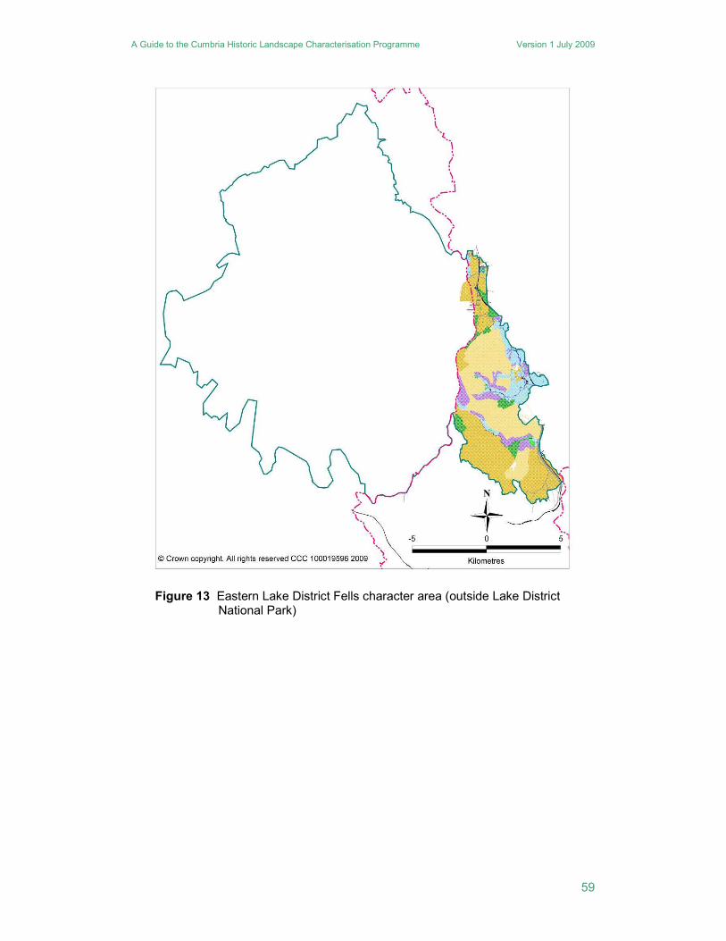
The Eastern Fells lie largely within the Lake District National Park, to the north of the Crosthwaite and Underbarrow Low Fells and the Windermere, and the Rothay and Brathay Valleys. The park boundary forms the south-eastern edge of the character area, though a tongue extends south-eastwards out of the park encompassing Birkbeck, Bretherdale and Whinfell commons. The character is defined by expanses of post medieval enclosures, both intakes and 19th century planned enclosures which extend onto the high moorland. The enclosures are large, and irregular in shape, defined mainly by topography, and in many places enclosure boundaries have not
A Guide to the Cumbria Historic Landscape Characterisation Programme Version 1 July 2009
58
been maintained and the character is reverting back to open moor. On the moorland, most enclosure boundaries comprise dry stone walls. Penetrating into the moorland are a number of narrow valleys. The main valleys are Troutbeck, Kentmere Longsleddale Borrowdale and Wetsleddale. A characteristic of this area is the use of some of the valleys for reservoirs and the associated use of the fells as water gathering grounds, which has influenced their other land uses since the earlier 20th century. The valleys contain almost all of the woodland within this character area, with concentrations of ancient woodland in Patterdale and Longsleddale. The western valleys of Patterdale, Troutbeck and Kentmere, have a more nucleated settlement pattern, and more extensive former common arable fields, though both the settlements and the fields lack the regularity of nucleated settlements in the Eden Valley or Solway Coast. In Kentmere, parts of the common arable fields were not enclosed until the 19th century. Longsleddale, and the other smaller valleys, are dominated by dispersed settlement and ancient closes, with only limited areas of former common arable fields.
Legacy: The valleys are generally pre-modern landscapes in which most settlements and enclosures originated before the late 18th century but the fells are characterised by 19th century enclosure, strong legibility of landscape elements of medieval origin, strong survival of archaeological features of all periods.
Landscape designation and status: Largely within the Lake District National Park.
Planning authorities: LDNPA, Eden District Council and South Lakeland District Council.
A Guide to the Cumbria Historic Landscape Characterisation Programme Version 1 July 2009
59
Figure 13 Eastern Lake District Fells character area (outside Lake District National Park)
A Guide to the Cumbria Historic Landscape Characterisation Programme Version 1 July 2009
60
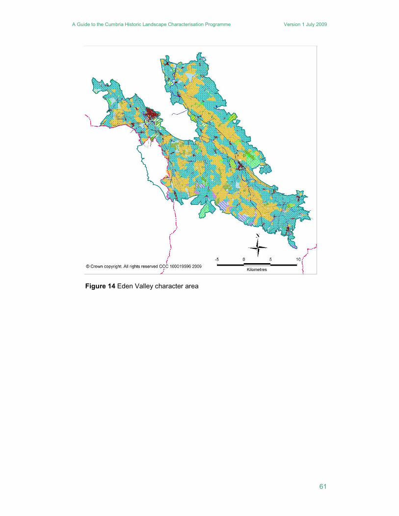
17. Eden Valley
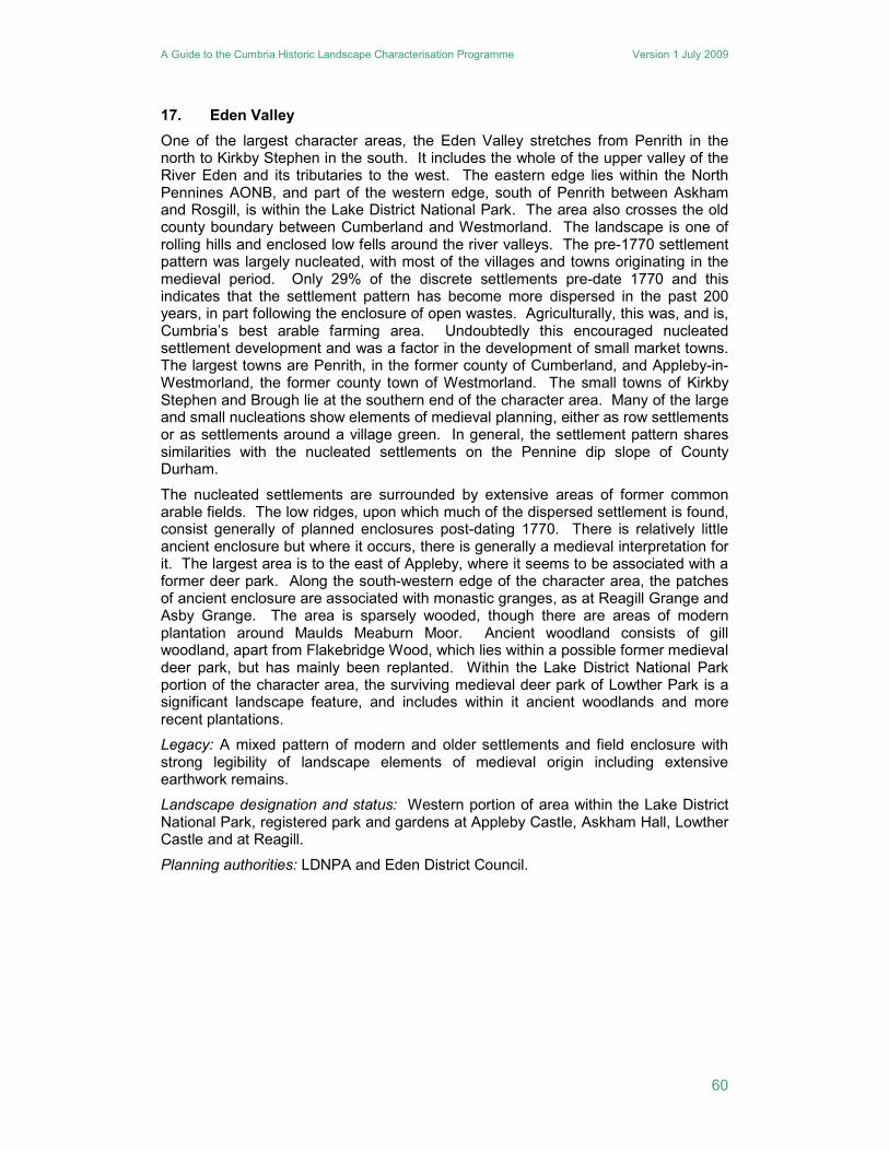
One of the largest character areas, the Eden Valley stretches from Penrith in the north to Kirkby Stephen in the south. It includes the whole of the upper valley of the River Eden and its tributaries to the west. The eastern edge lies within the North Pennines AONB, and part of the western edge, south of Penrith between Askham and Rosgill, is within the Lake District National Park. The area also crosses the old county boundary between Cumberland and Westmorland. The landscape is one of rolling hills and enclosed low fells around the river valleys. The pre-1770 settlement pattern was largely nucleated, with most of the villages and towns originating in the medieval period. Only 29% of the discrete settlements pre-date 1770 and this indicates that the settlement pattern has become more dispersed in the past 200 years, in part following the enclosure of open wastes. Agriculturally, this was, and is, Cumbria’s best arable farming area. Undoubtedly this encouraged nucleated settlement development and was a factor in the development of small market towns. The largest towns are Penrith, in the former county of Cumberland, and Appleby-in-Westmorland, the former county town of Westmorland. The small towns of Kirkby Stephen and Brough lie at the southern end of the character area. Many of the large and small nucleations show elements of medieval planning, either as row settlements or as settlements around a village green. In general, the settlement pattern shares similarities with the nucleated settlements on the Pennine dip slope of County Durham.
The nucleated settlements are surrounded by extensive areas of former common arable fields. The low ridges, upon which much of the dispersed settlement is found, consist generally of planned enclosures post-dating 1770. There is relatively little ancient enclosure but where it occurs, there is generally a medieval interpretation for it. The largest area is to the east of Appleby, where it seems to be associated with a former deer park. Along the south-western edge of the character area, the patches of ancient enclosure are associated with monastic granges, as at Reagill Grange and Asby Grange. The area is sparsely wooded, though there are areas of modern plantation around Maulds Meaburn Moor. Ancient woodland consists of gill woodland, apart from Flakebridge Wood, which lies within a possible former medieval deer park, but has mainly been replanted. Within the Lake District National Park portion of the character area, the surviving medieval deer park of Lowther Park is a significant landscape feature, and includes within it ancient woodlands and more recent plantations.
Legacy: A mixed pattern of modern and older settlements and field enclosure with strong legibility of landscape elements of medieval origin including extensive earthwork remains.
Landscape designation and status: Western portion of area within the Lake District National Park, registered park and gardens at Appleby Castle, Askham Hall, Lowther Castle and at Reagill.
Planning authorities: LDNPA and Eden District Council.
A Guide to the Cumbria Historic Landscape Characterisation Programme Version 1 July 2009
61
Figure 14 Eden Valley character area
A Guide to the Cumbria Historic Landscape Characterisation Programme Version 1 July 2009
62
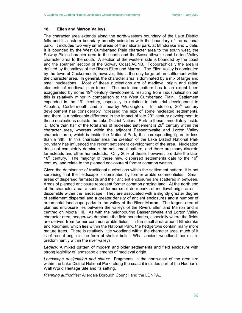
18. Ellen and Marron Valleys
The character area extends along the north-western boundary of the Lake District fells and its eastern boundary broadly coincides with the boundary of the national park. It includes two very small areas of the national park, at Blindcrake and Uldale. It is bounded by the West Cumberland Plain character area to the south west, the Solway Plain character area to the north and the Bassenthwaite and Lorton Valley character area to the south. A section of the western side is bounded by the coast and the southern section of the Solway Coast AONB. Topographically the area is defined by the valleys of the Rivers Ellen and Marron. The Ellen Valley is dominated by the town of Cockermouth, however, this is the only large urban settlement within the character area. In general, the character area is dominated by a mix of large and small nucleations. Most of these nucleations are of medieval origin and retain elements of medieval plan forms. The nucleated pattern has to an extent been exaggerated by some 19th century development, resulting from industrialisation but this is relatively minor in comparison to the West Cumberland Plain. Settlement expanded in the 19th century, especially in relation to industrial development in Aspatria, Cockermouth and in nearby Workington. In addition, 20th century development has considerably increased the size of some nucleated settlements, and there is a noticeable difference in the impact of late 20th century development to those nucleations outside the Lake District National Park to those immediately inside it. More than half of the total area of nucleated settlement is 20th century within the character area, whereas within the adjacent Bassenthwaite and Lorton Valley character area, which is inside the National Park, the corresponding figure is less than a fifth. In this character area the creation of the Lake District National Park boundary has influenced the recent settlement development of the area. Nucleation does not completely dominate the settlement pattern, and there are many discrete farmsteads and other homesteads. Only 26% of these, however, pre-date the late-18th century. The majority of these new, dispersed settlements date to the 19th century, and relate to the planned enclosure of former common wastes.
Given the dominance of traditional nucleations within the settlement pattern, it is not surprising that the fieldscape is dominated by former arable commonfields. Small areas of dispersed farmsteads and their ancient enclosures are scattered in between. Areas of planned enclosure represent former common grazing land. At the north end of the character area, a series of former small deer parks of medieval origin are still discernible within the landscape. They are associated with a slightly greater degree of settlement dispersal and a greater density of ancient enclosures and a number of ornamental landscape parks in the valley of the River Marron. The largest area of planned enclosure lies between the valleys of the Rivers Ellen and Marron and is centred on Moota Hill. As with the neighbouring Bassenthwaite and Lorton Valley character area, hedgerows dominate the field boundaries, especially where the fields are derived from former common arable fields. In the small area around Blindcrake and Redmain, which lies within the National Park, the hedgerows contain many more mature trees. There is relatively little woodland within the character area, much of it is of recent origin in the form of shelter belts. What ancient woodland there is, is predominantly within the river valleys.
Legacy: A mixed pattern of modern and older settlements and field enclosure with strong legibility of landscape elements of medieval origin.
Landscape designation and status: Fragments in the north-east of the area are within the Lake District National Park, along the coast it includes part of the Hadrian’s Wall World Heritage Site and its setting.
Planning authorities: Allerdale Borough Council and the LDNPA..
A Guide to the Cumbria Historic Landscape Characterisation Programme Version 1 July 2009
63
Figure 15 Ellen and Marron Valleys character area (outside the Lake District National Park)
A Guide to the Cumbria Historic Landscape Characterisation Programme Version 1 July 2009
64
19. Ennerdale
North of the Western Lake District Fell Edge, and south of the Bassenthwaite and Lorton Valley character area is Ennerdale. Its eastern boundary is shared with the Central Fells, and its character is defined by upland topography. The southern part comprises Ennerdale Water and its valley, whilst to the north are the Loweswater Fells. This area is sparsely populated and characterised by planned enclosure and plantation woodland. Most of the area was enclosed in the 19th century, with very large irregular stone-walled enclosures, typical of the higher fells. In many areas, these enclosures have not been maintained, and much of the area around Ennerdale is reverting back to open moorland. The large areas of coniferous woodland were planted by the Forestry Commission in the 20th century. Ennerdale is the subject of a rewilding scheme, and large areas of former plantation will be managed to allow the regeneration of native plant species.
Legacy: Largely 19th and 20th century landscape, moderate legibility of landscape elements of medieval origin, strong survival of medieval and earlier archaeological remains.
Landscape designation and status: Wholly within the Lake District National Park.
Planning authority: LDNPA.
20. Furness Fells
The Furness Fells character area lies almost wholly within but on the southern boundary of the Lake District National Park, south of Grizedale Forest. Its western boundary has been drawn along the River Crake, the eastern bank of which is heavily wooded. Part of the eastern boundary includes the southern section of Lake Windermere. The character of this area is distinguished by large areas of ancient woodland, much of which was coppiced to serve various woodland industries, such as iron processing, gunpowder manufacture and bobbin making. Ancient woodland occurs across the area, but the greatest concentration is in the eastern half, between the Rusland Valley and Lake Windermere. The settlement pattern is a mix of discrete settlements and small nucleations with a dominance of small nucleations along the Leven Valley, around Haverthwaite and Backbarrow, where iron and gunpowder industries developed. The Rusland Valley is an area of planned enclosure of reclaimed wetland, and the less well-wooded areas in the eastern half is anciently enclosed land, with some intakes. The field boundaries are a mix of stone walls, generally in the more upland and anciently enclosed areas, and hedgerows, in the low-lying areas of planned and ancient enclosure.
Legacy: A mixed pattern of modern and older settlements and field enclosure with moderate legibility of landscape elements of medieval origin, strong survival of industrial features.
Landscape designation and status: Almost wholly within the Lake District National Park.
Planning authority: LDNPA and South Lakeland District Council.
A Guide to the Cumbria Historic Landscape Characterisation Programme Version 1 July 2009
65
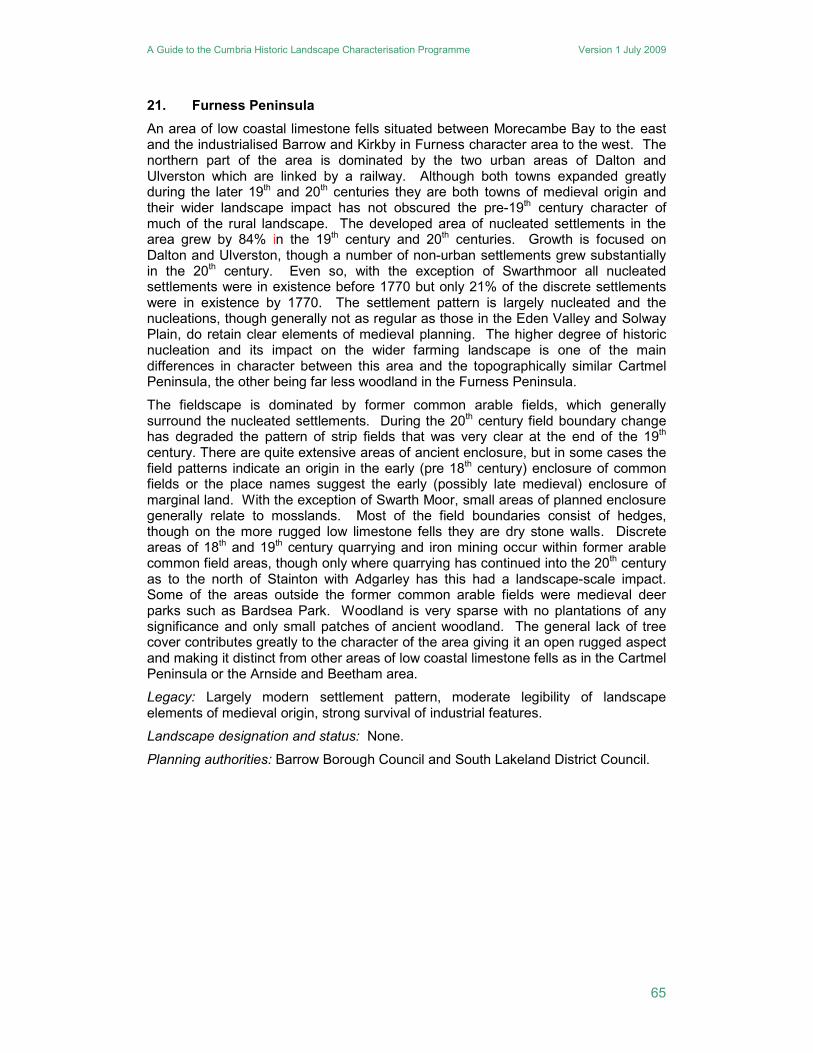
21. Furness Peninsula
An area of low coastal limestone fells situated between Morecambe Bay to the east and the industrialised Barrow and Kirkby in Furness character area to the west. The northern part of the area is dominated by the two urban areas of Dalton and Ulverston which are linked by a railway. Although both towns expanded greatly during the later 19th and 20th centuries they are both towns of medieval origin and their wider landscape impact has not obscured the pre-19th century character of much of the rural landscape. The developed area of nucleated settlements in the area grew by 84% in the 19th century and 20th centuries. Growth is focused on Dalton and Ulverston, though a number of non-urban settlements grew substantially in the 20th century. Even so, with the exception of Swarthmoor all nucleated settlements were in existence before 1770 but only 21% of the discrete settlements were in existence by 1770. The settlement pattern is largely nucleated and the nucleations, though generally not as regular as those in the Eden Valley and Solway Plain, do retain clear elements of medieval planning. The higher degree of historic nucleation and its impact on the wider farming landscape is one of the main differences in character between this area and the topographically similar Cartmel Peninsula, the other being far less woodland in the Furness Peninsula.
The fieldscape is dominated by former common arable fields, which generally surround the nucleated settlements. During the 20th century field boundary change has degraded the pattern of strip fields that was very clear at the end of the 19th century. There are quite extensive areas of ancient enclosure, but in some cases the field patterns indicate an origin in the early (pre 18th century) enclosure of common fields or the place names suggest the early (possibly late medieval) enclosure of marginal land. With the exception of Swarth Moor, small areas of planned enclosure generally relate to mosslands. Most of the field boundaries consist of hedges, though on the more rugged low limestone fells they are dry stone walls. Discrete areas of 18th and 19th century quarrying and iron mining occur within former arable common field areas, though only where quarrying has continued into the 20th century as to the north of Stainton with Adgarley has this had a landscape-scale impact. Some of the areas outside the former common arable fields were medieval deer parks such as Bardsea Park. Woodland is very sparse with no plantations of any significance and only small patches of ancient woodland. The general lack of tree cover contributes greatly to the character of the area giving it an open rugged aspect and making it distinct from other areas of low coastal limestone fells as in the Cartmel Peninsula or the Arnside and Beetham area.
Legacy: Largely modern settlement pattern, moderate legibility of landscape elements of medieval origin, strong survival of industrial features.
Landscape designation and status: None.
Planning authorities: Barrow Borough Council and South Lakeland District Council.
A Guide to the Cumbria Historic Landscape Characterisation Programme Version 1 July 2009
66
Figure 16 Furness Peninsula character area
A Guide to the Cumbria Historic Landscape Characterisation Programme Version 1 July 2009
67
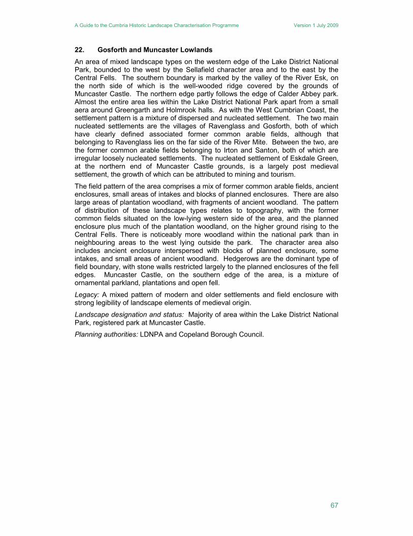
22. Gosforth and Muncaster Lowlands
An area of mixed landscape types on the western edge of the Lake District National Park, bounded to the west by the Sellafield character area and to the east by the Central Fells. The southern boundary is marked by the valley of the River Esk, on the north side of which is the well-wooded ridge covered by the grounds of Muncaster Castle. The northern edge partly follows the edge of Calder Abbey park. Almost the entire area lies within the Lake District National Park apart from a small aera around Greengarth and Holmrook halls. As with the West Cumbrian Coast, the settlement pattern is a mixture of dispersed and nucleated settlement. The two main nucleated settlements are the villages of Ravenglass and Gosforth, both of which have clearly defined associated former common arable fields, although that belonging to Ravenglass lies on the far side of the River Mite. Between the two, are the former common arable fields belonging to Irton and Santon, both of which are irregular loosely nucleated settlements. The nucleated settlement of Eskdale Green, at the northern end of Muncaster Castle grounds, is a largely post medieval settlement, the growth of which can be attributed to mining and tourism.
The field pattern of the area comprises a mix of former common arable fields, ancient enclosures, small areas of intakes and blocks of planned enclosures. There are also large areas of plantation woodland, with fragments of ancient woodland. The pattern of distribution of these landscape types relates to topography, with the former common fields situated on the low-lying western side of the area, and the planned enclosure plus much of the plantation woodland, on the higher ground rising to the Central Fells. There is noticeably more woodland within the national park than in neighbouring areas to the west lying outside the park. The character area also includes ancient enclosure interspersed with blocks of planned enclosure, some intakes, and small areas of ancient woodland. Hedgerows are the dominant type of field boundary, with stone walls restricted largely to the planned enclosures of the fell edges. Muncaster Castle, on the southern edge of the area, is a mixture of ornamental parkland, plantations and open fell.
Legacy: A mixed pattern of modern and older settlements and field enclosure with strong legibility of landscape elements of medieval origin.
Landscape designation and status: Majority of area within the Lake District National Park, registered park at Muncaster Castle.
Planning authorities: LDNPA and Copeland Borough Council.
A Guide to the Cumbria Historic Landscape Characterisation Programme Version 1 July 2009
68
Figure 17 Gosforth and Muncaster Lowlands character area (outside the Lake District National Park)
A Guide to the Cumbria Historic Landscape Characterisation Programme Version 1 July 2009
69
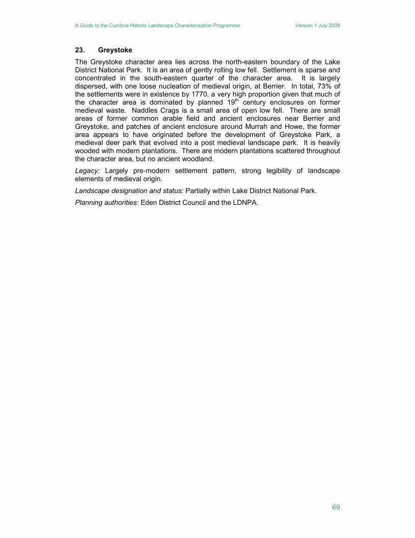
23. Greystoke
The Greystoke character area lies across the north-eastern boundary of the Lake District National Park. It is an area of gently rolling low fell. Settlement is sparse and concentrated in the south-eastern quarter of the character area. It is largely dispersed, with one loose nucleation of medieval origin, at Berrier. In total, 73% of the settlements were in existence by 1770, a very high proportion given that much of the character area is dominated by planned 19th century enclosures on former medieval waste. Naddles Crags is a small area of open low fell. There are small areas of former common arable field and ancient enclosures near Berrier and Greystoke, and patches of ancient enclosure around Murrah and Howe, the former area appears to have originated before the development of Greystoke Park, a medieval deer park that evolved into a post medieval landscape park. It is heavily wooded with modern plantations. There are modern plantations scattered throughout the character area, but no ancient woodland.
Legacy: Largely pre-modern settlement pattern, strong legibility of landscape elements of medieval origin.
Landscape designation and status: Partially within Lake District National Park.
Planning authorities: Eden District Council and the LDNPA.
A Guide to the Cumbria Historic Landscape Characterisation Programme Version 1 July 2009
70
Figure 18 Greystoke character area (outside the Lake District National Park)
A Guide to the Cumbria Historic Landscape Characterisation Programme Version 1 July 2009
71
24. Grizedale Forest
Grizedale Forest lies between Coniston Water and Lake Windermere. To the south it is bounded by the Furness Fells, and to the north by the Central Fells. The whole of Coniston Water and the northern half of Lake Windermere are included within the character area, which also includes Esthwaite Water. It is dominanted by large areas of woodland plantation, much of which is contained within Grizedale Forest Park. The woodland was planted from the late eighteenth century onwards in areas of intaking and planned enclosure, and much of it is still coniferous. There is a small area of open fell, Bethecar Moor, on the southern edge, overlooking Coniston Water. The valleys and lower lying ground, mostly in the northern half, are less wooded, and comprise areas of former open field in the valleys, around which are ancient enclosures, with intakes on the higher ground. The woodland in this area is more fragmentary, and is probably a mix of ornamental and commercial planting in the nineteenth and early twentieth centuries, for example at Wray Castle. The northern limits of the area are defined by the valley of the River Brathay, where the landscape comprises more of a patchwork of ancient enclosures and irregular plantation woodland. Field boundaries are a mix of hedgerows and stone walls, with hedgerows dominating the areas of ancient enclosure. The settlement pattern, too, is mixed, with dispersed farms and small nucleations, often associated with industry.
Legacy: A largely 19th and 20th century landscape dominated by woodland, moderate legibility of landscape elements of medieval origin, moderate survival of industrial features.
Landscape designation and status: Wholly within the Lake District National Park.
Planning authority: LDNPA.
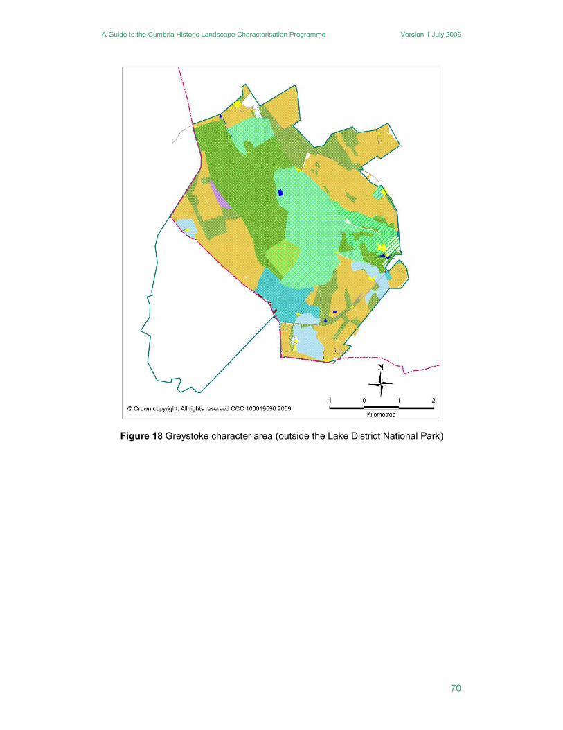
25. Howgills
This character area consists largely of unenclosed upland, forming the northern part of the Howgill Hills. The character area clearly extends to the south into the Yorkshire Dales National Park, which was the subject of a separate HLC programme. Settlement is almost wholly discrete and is concentrated in four valleys. On the western edge is the Lune Gorge, and on the eastern edge is the Mallerstang, formed by the upper reaches of the River Eden. Towards the centre of the area are two valleys which form a pass through the Howgills. The valley of the Scandal Beck flows north into the Lune catchment, and to the south the Sally Beck flows into the River Rawthey. Of the discrete settlements within these valleys, 53% pre-date 1770, some originating as medieval assarts, and the remainder date to the early 19th century. The vast majority of the area is unenclosed fell and moorland. The enclosures within the valleys are largely ancient fields including intakes, and there are only small patches of 19th century planned enclosure. Parts of the anciently enclosed landscapes of Mallerstang were altered when they were turned into deer parks at Pendragon and Wharton, the latter dating to the mid-16th century. There is very little woodland, and most is ancient gill woodland, with the most significant area lying to the south of Adamthwaite.
Legacy: A mixed pattern of modern and older settlements and field enclosure, strong legibility of landscape elements of medieval origin with extensive earthwork remains.
Landscape designation and status: None but area is identical to adjacent area that is included within the Yorkshire Dales National Park.
Planning authority: Eden District Council.
A Guide to the Cumbria Historic Landscape Characterisation Programme Version 1 July 2009
72
Figure 19 Howgills character area
A Guide to the Cumbria Historic Landscape Characterisation Programme Version 1 July 2009
73
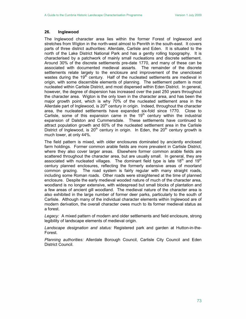
26. Inglewood
The Inglewood character area lies within the former Forest of Inglewood and stretches from Wigton in the north-west almost to Penrith in the south-east. It covers parts of three district authorities: Allerdale, Carlisle and Eden. It is situated to the north of the Lake District National Park and has a gently rolling topography. It is characterised by a patchwork of mainly small nucleations and discrete settlement. Around 30% of the discrete settlements pre-date 1770, and many of these can be associated with documented medieval assarts. The remainder of the discrete settlements relate largely to the enclosure and improvement of the unenclosed wastes during the 19th century. Half of the nucleated settlements are medieval in origin, with some discernible elements of planning. The settlement pattern is most nucleated within Carlisle District, and most dispersed within Eden District. In general, however, the degree of dispersion has increased over the past 250 years throughout the character area. Wigton is the only town in the character area, and has been the major growth point, which is why 70% of the nucleated settlement area in the Allerdale part of Inglewood, is 20th century in origin. Indeed, throughout the character area, the nucleated settlements have expanded six-fold since 1770. Close to Carlisle, some of this expansion came in the 19th century within the industrial expansion of Dalston and Cummersdale. These settlements have continued to attract population growth and 60% of the nucleated settlement area in the Carlisle District of Inglewood, is 20th century in origin. In Eden, the 20th century growth is much lower, at only 44%.
The field pattern is mixed, with older enclosures dominated by anciently enclosed farm holdings. Former common arable fields are more prevalent in Carlisle District, where they also cover larger areas. Elsewhere former common arable fields are scattered throughout the character area, but are usually small. In general, they are associated with nucleated villages. The dominant field type is late 18th and 19th century planned enclosures, reflecting the formerly extensive areas of moorland common grazing. The road system is fairly regular with many straight roads, including some Roman roads. Other roads were straightened at the time of planned enclosure. Despite the early medieval wooded nature of much of the character area, woodland is no longer extensive, with widespread but small blocks of plantation and a few areas of ancient gill woodland. The medieval nature of the character area is also exhibited in the large number of former deer parks, particularly to the south of Carlisle. Although many of the individual character elements within Inglewood are of modern derivation, the overall character owes much to its former medieval status as a forest.
Legacy: A mixed pattern of modern and older settlements and field enclosure, strong legibility of landscape elements of medieval origin.
Landscape designation and status: Registered park and garden at Hutton-in-the-Forest.
Planning authorities: Allerdale Borough Council, Carlisle City Council and Eden District Council.
A Guide to the Cumbria Historic Landscape Characterisation Programme Version 1 July 2009
74
Figure 20 Inglewood character area
A Guide to the Cumbria Historic Landscape Characterisation Programme Version 1 July 2009
75
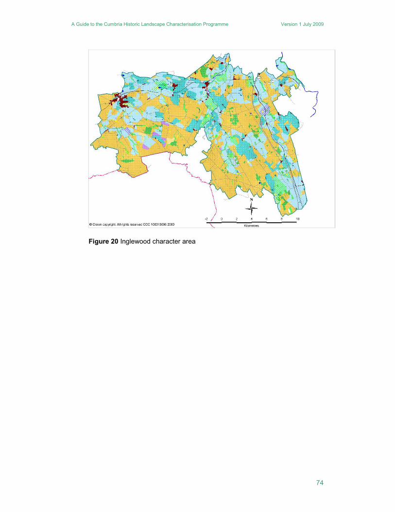
27. Irthing Valley
The River Irthing and its tributaries are the main topographical features of this character area. Much of the character area is within the Hadrian’s Wall World Heritage site visual impact zone. The line of the Wall runs to the north of the River Irthing, and for part of its length forms a discernible feature within the local fieldscape. Aside from Brampton, a medieval market town, there are relatively few nucleations and most are small. Around half of all nucleated settlements have origins which pre-date 1770, but there is little evidence of medieval planning other than at Talkin. The settlement pattern is predominantly dispersed, with 39% of the discrete settlements pre-dating 1770, and 47% are of 19th century origin. Many of the discrete settlements are around the edge of former common waste, and some of the discrete and nucleated 19th century settlements relate to small-scale rural industry, including coal mining.
Although much of the settlement pattern appears to be of relatively recent origin, the field systems have much older roots. The character area is dominated by ancient enclosures with former common arable areas associated with the principal older nucleations, such as Walton, Brampton, Farlam and Talkin. Planned enclosures are largely confined to low moorlands. The area is reasonably well wooded, with Miltonrigg Wood, to the east of Brampton, forming quite an extensive area of ancient woodland. The remainder of the ancient woodland is confined to the valleys of the River Irthing, Cam Beck, King Water and River Gelt. Plantation woodlands within the character area are of two principal types: mixed, usually small woodlands within both ancient and planned enclosure areas, and plantations within landscape parks. The most significant of the latter are the mixed woodlands in Naworth Park, the ornamental grounds surrounding Naworth Castle.
Legacy: A mixed pattern of modern and older settlements and field enclosure, moderate legibility of landscape elements of medieval origin.
Landscape designation and status: Includes part of the Hadrian’s Wall World Heritage Site and its setting.
Planning authority: Carlisle City Council.
A Guide to the Cumbria Historic Landscape Characterisation Programme Version 1 July 2009
76
Figure 21 Irthing Valley character area
A Guide to the Cumbria Historic Landscape Characterisation Programme Version 1 July 2009
77
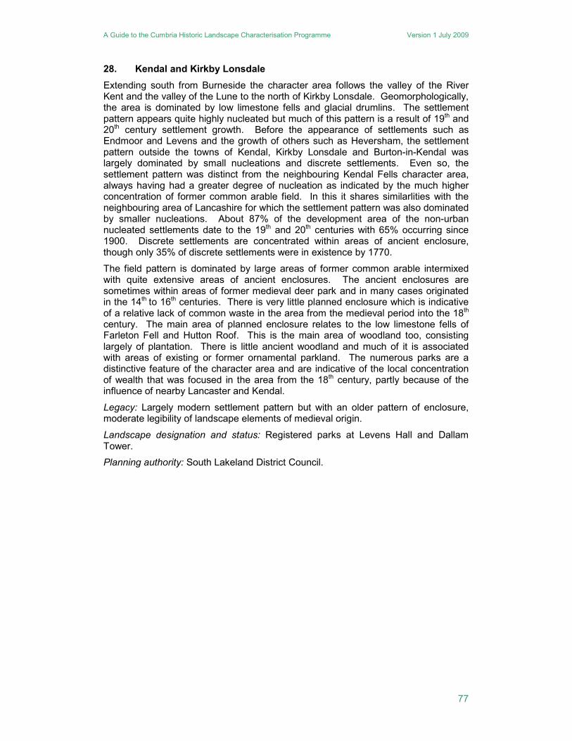
28. Kendal and Kirkby Lonsdale
Extending south from Burneside the character area follows the valley of the River Kent and the valley of the Lune to the north of Kirkby Lonsdale. Geomorphologically, the area is dominated by low limestone fells and glacial drumlins. The settlement pattern appears quite highly nucleated but much of this pattern is a result of 19th and 20th century settlement growth. Before the appearance of settlements such as Endmoor and Levens and the growth of others such as Heversham, the settlement pattern outside the towns of Kendal, Kirkby Lonsdale and Burton-in-Kendal was largely dominated by small nucleations and discrete settlements. Even so, the settlement pattern was distinct from the neighbouring Kendal Fells character area, always having had a greater degree of nucleation as indicated by the much higher concentration of former common arable field. In this it shares similarlities with the neighbouring area of Lancashire for which the settlement pattern was also dominated by smaller nucleations. About 87% of the development area of the non-urban nucleated settlements date to the 19th and 20th centuries with 65% occurring since 1900. Discrete settlements are concentrated within areas of ancient enclosure, though only 35% of discrete settlements were in existence by 1770.
The field pattern is dominated by large areas of former common arable intermixed with quite extensive areas of ancient enclosures. The ancient enclosures are sometimes within areas of former medieval deer park and in many cases originated in the 14th to 16th centuries. There is very little planned enclosure which is indicative of a relative lack of common waste in the area from the medieval period into the 18th century. The main area of planned enclosure relates to the low limestone fells of Farleton Fell and Hutton Roof. This is the main area of woodland too, consisting largely of plantation. There is little ancient woodland and much of it is associated with areas of existing or former ornamental parkland. The numerous parks are a distinctive feature of the character area and are indicative of the local concentration of wealth that was focused in the area from the 18th century, partly because of the influence of nearby Lancaster and Kendal.
Legacy: Largely modern settlement pattern but with an older pattern of enclosure, moderate legibility of landscape elements of medieval origin.
Landscape designation and status: Registered parks at Levens Hall and Dallam Tower.
Planning authority: South Lakeland District Council.
A Guide to the Cumbria Historic Landscape Characterisation Programme Version 1 July 2009
78
Figure 22 Kendal and Kirkby Lonsdale character area
A Guide to the Cumbria Historic Landscape Characterisation Programme Version 1 July 2009
79
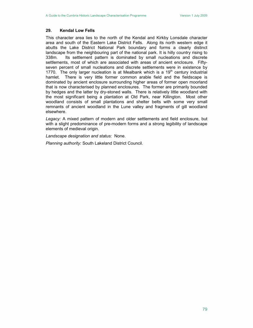
29. Kendal Low Fells
This character area lies to the north of the Kendal and Kirkby Lonsdale character area and south of the Eastern Lake District Fells. Along its north western edge it abutts the Lake District National Park boundary and forms a clearly distinct landscape from the neighbouring part of the national park. It is hilly country rising to 338m. Its settlement pattern is dominated by small nucleations and discrete settlements, most of which are associated with areas of ancient enclosure. Fifty-seven percent of small nucleations and discrete settlements were in existence by 1770. The only larger nucleation is at Mealbank which is a 19th century industrial hamlet. There is very little former common arable field and the fieldscape is dominated by ancient enclosure surrounding higher areas of former open moorland that is now characterised by planned enclosures. The former are primarily bounded by hedges and the latter by dry-stoned walls. There is relatively little woodland with the most significant being a plantation at Old Park, near Killington. Most other woodland consists of small plantations and shelter belts with some very small remnants of ancient woodland in the Lune valley and fragments of gill woodland elsewhere.
Legacy: A mixed pattern of modern and older settlements and field enclosure, but with a slight predominance of pre-modern forms and a strong legibility of landscape elements of medieval origin.
Landscape designation and status: None.
Planning authority: South Lakeland District Council.
A Guide to the Cumbria Historic Landscape Characterisation Programme Version 1 July 2009
80
Figure 23 Kendal Low Fells character area
A Guide to the Cumbria Historic Landscape Characterisation Programme Version 1 July 2009
81
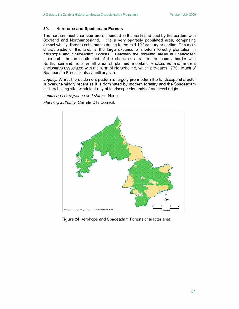
30. Kershope and Spadeadam Forests
The northernmost character area, bounded to the north and east by the borders with Scotland and Northumberland. It is a very sparsely populated area, comprising almost wholly discrete settlements dating to the mid-19th century or earlier. The main characteristic of this area is the large expanse of modern forestry plantation in Kershope and Spadeadam Forests. Between the forested areas is unenclosed moorland. In the south east of the character area, on the county border with Northumberland, is a small area of planned moorland enclosures and ancient enclosures associated with the farm of Horseholme, which pre-dates 1770. Much of Spadeadam Forest is also a military site.
Legacy: Whilst the settlement pattern is largely pre-modern the landscape character is overwhelmingly recent as it is dominated by modern forestry and the Spadeadam military testing site, weak legibility of landscape elements of medieval origin.
Landscape designation and status: None.
Planning authority: Carlisle City Council.
Figure 24 Kershope and Spadeadam Forests character area
A Guide to the Cumbria Historic Landscape Characterisation Programme Version 1 July 2009
82
31. Keswick and Derwent Water
South of the Skiddaw Range, and north of the Central Fells, is the area around Derwent Water and the town of Keswick. Like the Windermere area, this is one of the key destinations for visitors to the Lake District National Park, and its character partly reflects this, taking in Keswick and the lake, and the approaches to it from the east. The area around Derwent Water is largely wooded, with plantations but also significant areas of ancient woodland. West of Keswick is an area of ancient enclosures, and south of Derwent Water is the head of Borrowdale with its former open field. Immediately north of Keswick is a large area of intakes, at Latrigg and Ormathwaite, with areas of plantation and ancient woodland, which formed an important part in the itinerary of the eighteenth and nineteenth century traveller interested in the Picturesque. The landscape of the valley to the east of Keswick is based around the village of Threlkeld, and its small former open field, and comprises mostly ancient enclosures with some intakes. This approach to Keswick from the east is now dominated by the A66 trunk road and the bypass to the north of Keswick. Although the eastern part of this area is not well wooded, the Greta Valley has ancient woodland, and the field boundaries comprise hedgerows with numerous standard trees. In addition, there have been substantial programmes of ornamental planting, designed to enhance the Picturesque view, around Derwent Water and the lower fells north of Keswick.
Legacy: A mixed pattern of modern and older settlements and field enclosure, strong legibility of landscape elements associated with 18th and 19th century aesthetics, moderate legibility of landscape elements of medieval origin.
Landscape designation and status: Wholly within the Lake District National Park.
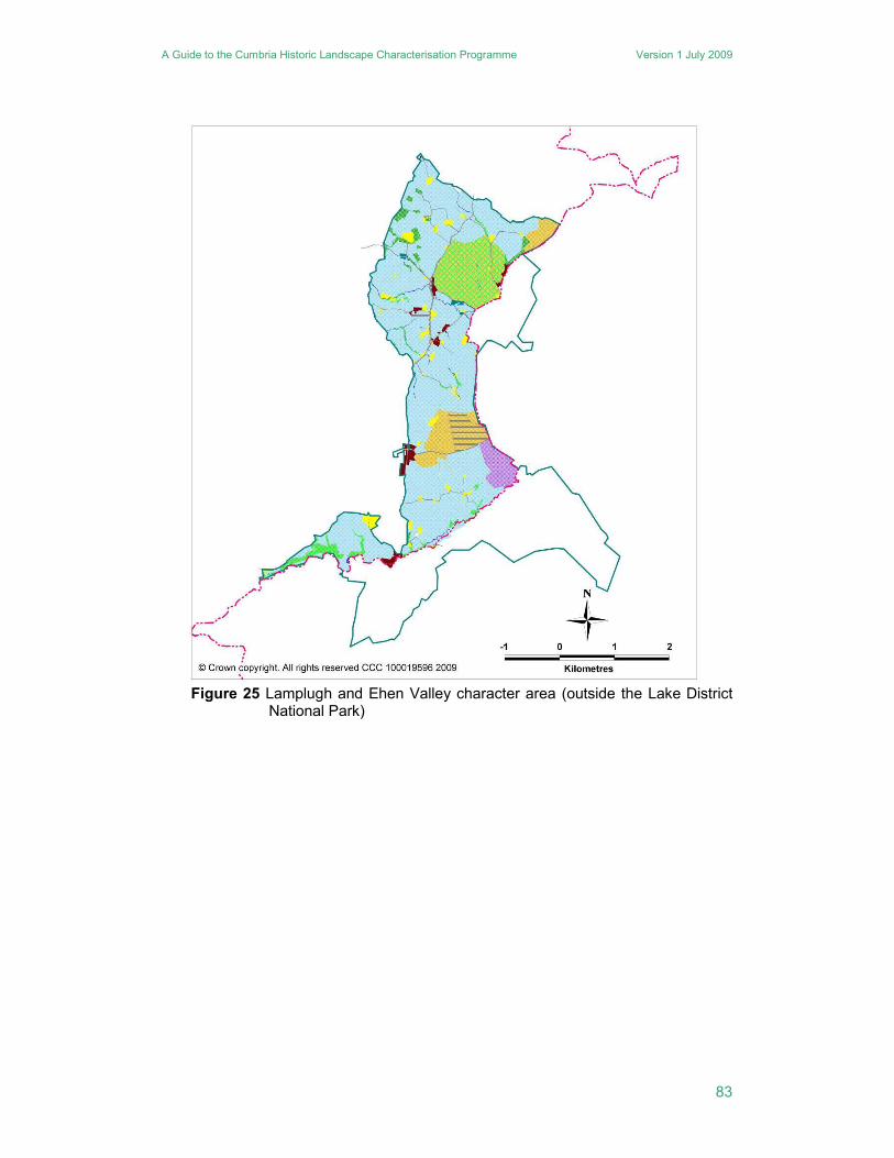
32. Lamplugh and Ehen Valley
An area of rolling landscape rising towards the Lake District fells this character area straddles the Lake District National Park boundary to the east of Frizington. There is no obvious distinction in terms of historic landscape character between the areas within and without the park. It is characterised primarily by the extensive area of ancient enclosure. Unlike the Whillimore and Dean Common character area to the west, the settlement pattern within the ancient enclosures does not only consist of discrete settlements but also includes small nucleations, such as Asby, Kirkland, Croasdale and Ennerdale Bridge. Exactly two thirds of all the settlements pre-date 1770. Other than a few small areas of planned enclosure, the field pattern entirely consists of ancient enclosures with no former common arable fields. Woodland is sparse but there are small patches of ancient gill woodland and small blocks of plantation in the north of the area. Overall the landscape appears to retain many pre-19th century characteristics.
Legacy: A clearly older and traditional landscape both with regard to settlement pattern and the nature of the fieldscape, strong legibility of landscape elements of medieval origin.
Landscape designation and status: Small parts of the eastern half of the character area are within the Lake District National Park.
Planning authority: Copeland Borough Council and LDNPA.
A Guide to the Cumbria Historic Landscape Characterisation Programme Version 1 July 2009
83
Figure 25 Lamplugh and Ehen Valley character area (outside the Lake District
National Park)
A Guide to the Cumbria Historic Landscape Characterisation Programme Version 1 July 2009
84
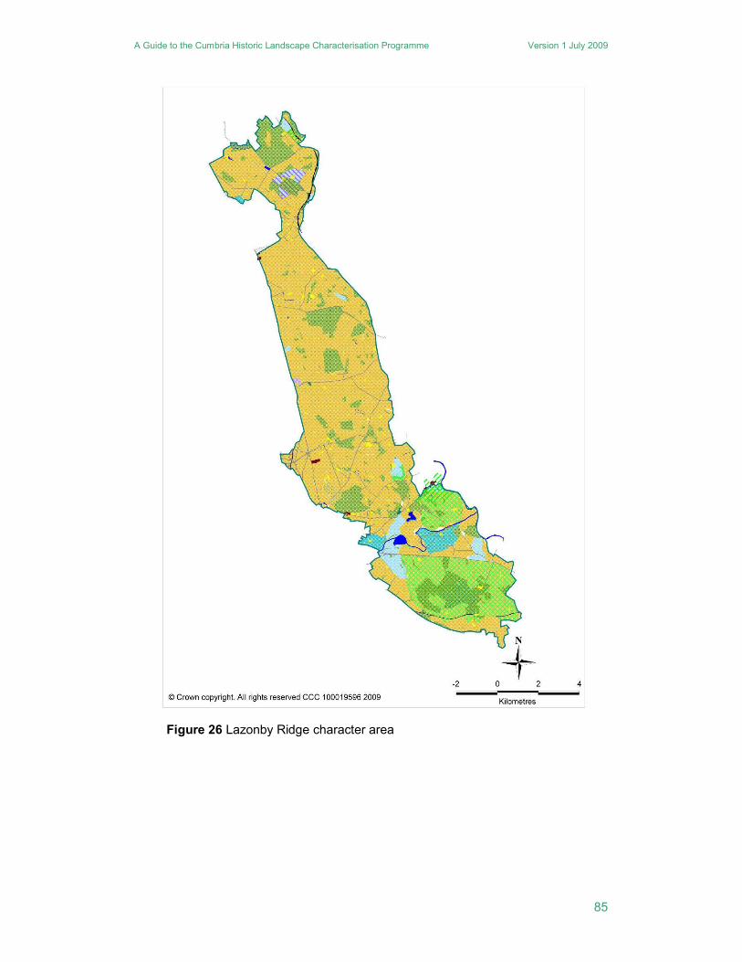
33. Lazonby Ridge
This is an area of low fell stretching from Cumwhitton in the north, in Carlisle District, to Cliburn in the south, in Eden District. Formerly the area to the north of Penrith was in Inglewood Forest, whilst the smaller area to the south was part of Whinfell Forest, the two separated by the valley of the River Eamont. Outside the Eamont valley, the majority of the area remained open and unenclosed until the 19th century. Consequently, only 8% of the settlements pre-date 1770. Settlement is generally sparse and largely dispersed. Throughout the area, 88% of the settlements are discrete holdings.
The area is dominated strongly by planned enclosures of post-1770 date. Within the Eamont valley, however, there are small areas of ancient enclosure, associated with discrete holdings and small nucleations. There are very few areas of surviving ancient woodland, although some areas of woodland surviving into the 19th century, have been replanted with modern plantation, such as on Whinfell. The area is quite well-wooded, though this predominantly comprises modern forestry plantation. Whilst the settlement pattern and field pattern are of relatively modern origin, their development, and the generally sparsely populated nature of the area, is a consequence of the area’s use as medieval hunting preserves, either forests or, as at Edenhall, deer parks.
Legacy: Largely modern settlement pattern and the landscape character is overwhelmingly recent as it is dominated by modern forestry, weak legibility of landscape elements of medieval origin.
Landscape designation and status: None.
Planning authority: Eden District Council.
A Guide to the Cumbria Historic Landscape Characterisation Programme Version 1 July 2009
85
Figure 26 Lazonby Ridge character area
A Guide to the Cumbria Historic Landscape Characterisation Programme Version 1 July 2009
86
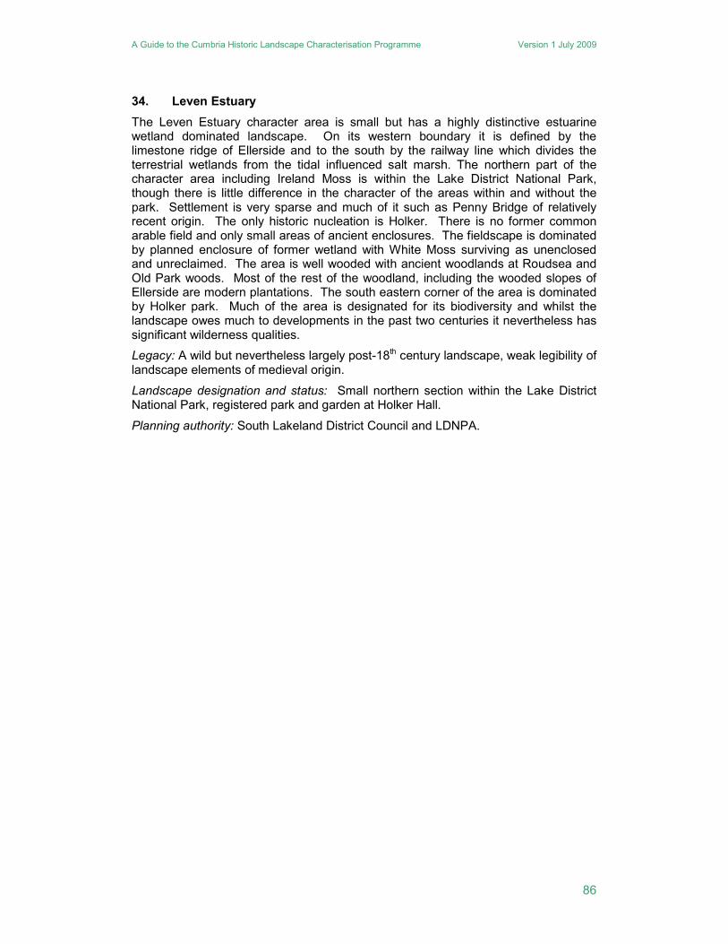
34. Leven Estuary
The Leven Estuary character area is small but has a highly distinctive estuarine wetland dominated landscape. On its western boundary it is defined by the limestone ridge of Ellerside and to the south by the railway line which divides the terrestrial wetlands from the tidal influenced salt marsh. The northern part of the character area including Ireland Moss is within the Lake District National Park, though there is little difference in the character of the areas within and without the park. Settlement is very sparse and much of it such as Penny Bridge of relatively recent origin. The only historic nucleation is Holker. There is no former common arable field and only small areas of ancient enclosures. The fieldscape is dominated by planned enclosure of former wetland with White Moss surviving as unenclosed and unreclaimed. The area is well wooded with ancient woodlands at Roudsea and Old Park woods. Most of the rest of the woodland, including the wooded slopes of Ellerside are modern plantations. The south eastern corner of the area is dominated by Holker park. Much of the area is designated for its biodiversity and whilst the landscape owes much to developments in the past two centuries it nevertheless has significant wilderness qualities.
Legacy: A wild but nevertheless largely post-18th century landscape, weak legibility of landscape elements of medieval origin.
Landscape designation and status: Small northern section within the Lake District National Park, registered park and garden at Holker Hall.
Planning authority: South Lakeland District Council and LDNPA.
A Guide to the Cumbria Historic Landscape Characterisation Programme Version 1 July 2009
87
Figure 27 Leven Estuary character area
A Guide to the Cumbria Historic Landscape Characterisation Programme Version 1 July 2009
88
35. Matterdale and Ullswater
In the north eastern quadrant of the Lake District National Park, is an area of lowlands extending from Ullswater to the National Park boundary. The character of the area is similar to that of the Bassenthwaite and Lorton valley character area, and is a patchwork of enclosure types, with comparatively large areas of former common arable fields, ancient enclosures and planned enclosure. There are few intakes, mostly around the fell edges. The settlement pattern is generally dispersed but with some significant nucleations such as Pooley Bridge, Dacre and Penruddock. The number of discrete settlements has increased since the late 18th century with 44% originating after 1770. It has country houses and ornamental parks, such as Glencoyne and Dalemain. Around the shores of Ullswater are a number of 19th century villas. Ornamental tree planting features both in the parks and around the northern shores of Ullswater. Elsewhere coniferous plantation has been carried out in areas of planned enclosure on former common waste, around Great Mell Fell. As with many of the other low lying areas, hedgerows predominate as field boundaries, with stone walls on the higher areas of planned enclosure, but also with some fencing on low lying lands.
Legacy: A mixed pattern of modern and older settlements and field enclosure, but with a slight predominance of pre-modern forms, strong legibility of landscape elements associated with 18th and 19th century aesthetics, moderate legibility of landscape elements of medieval origin.
Landscape designation and status: Wholly within the Lake District National Park, registered park and garden at Dalemain.
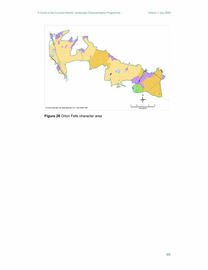
36. Orton Fells
The Orton Fells is an upland character area situated between the Eden Valley and the upper Lune Valley, that links the Lake District and Pennine uplands. Its principal character is defined by its limestone karst scenery, with extensive limestone pavements. Its land use was dominated by settlements in the Eden and Lune valleys, whilst it is very sparsely settled. It has no nucleated settlements, and only two discrete settlements which pre-date 1770. Both of these, Mazon Wath and Beck Head, appear to have originated as medieval assarts. The remaining eight discrete settlements date to the first half of the 19th century, and are situated either within planned enclosures or on the edge of assarts. The field systems are a mix largely of unenclosed fell, planned enclosures and intakes. The earliest enclosures are associated with the assarts and the former Ravenstonedale medieval deer park. The former deer park is one of the main places for plantation woodland within the character area. Woodlands in general are few and small, and there is very little ancient woodland, the main area being Smardale Gill.
Legacy: A largely uninhabited upland landscape of mainly pre-modern origins, strong legibility of landscape elements of medieval origin with well preserved archaeological remains of all periods.
Landscape designation and status: None.
Planning authority: Eden District Council.
A Guide to the Cumbria Historic Landscape Characterisation Programme Version 1 July 2009
89
Figure 28 Orton Fells character area
A Guide to the Cumbria Historic Landscape Characterisation Programme Version 1 July 2009
90
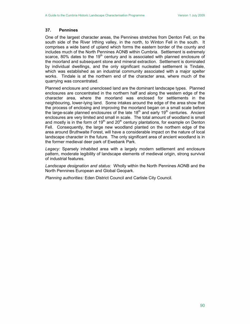
37. Pennines
One of the largest character areas, the Pennines stretches from Denton Fell, on the south side of the River Irthing valley, in the north, to Winton Fell in the south. It comprises a wide band of upland which forms the eastern border of the county and includes much of the North Pennines AONB within Cumbria. Settlement is extremely scarce, 80% dates to the 19th century and is associated with planned enclosure of the moorland and subsequent stone and mineral extraction. Settlement is dominated by individual dwellings, and the only significant nucleated settlement is Tindale, which was established as an industrial community associated with a major spelter works. Tindale is at the northern end of the character area, where much of the quarrying was concentrated.
Planned enclosure and unenclosed land are the dominant landscape types. Planned enclosures are concentrated in the northern half and along the western edge of the character area, where the moorland was enclosed for settlements in the neighbouring, lower-lying land. Some intakes around the edge of the area show that the process of enclosing and improving the moorland began on a small scale before the large-scale planned enclosures of the late 18th and early 19th centuries. Ancient enclosures are very limited and small in scale. The total amount of woodland is small and mostly is in the form of 19th and 20th century plantations, for example on Denton Fell. Consequently, the large new woodland planted on the northern edge of the area around Bruthwaite Forest, will have a considerable impact on the nature of local landscape character in the future. The only significant area of ancient woodland is in the former medieval deer park of Ewebank Park.
Legacy: Sparsely inhabited area with a largely modern settlement and enclosure pattern, moderate legibility of landscape elements of medieval origin, strong survival of industrial features.
Landscape designation and status: Wholly within the North Pennines AONB and the North Pennines European and Global Geopark.
Planning authorities: Eden District Council and Carlisle City Council.
A Guide to the Cumbria Historic Landscape Characterisation Programme Version 1 July 2009
91
Figure 29 Pennines character area
A Guide to the Cumbria Historic Landscape Characterisation Programme Version 1 July 2009
92
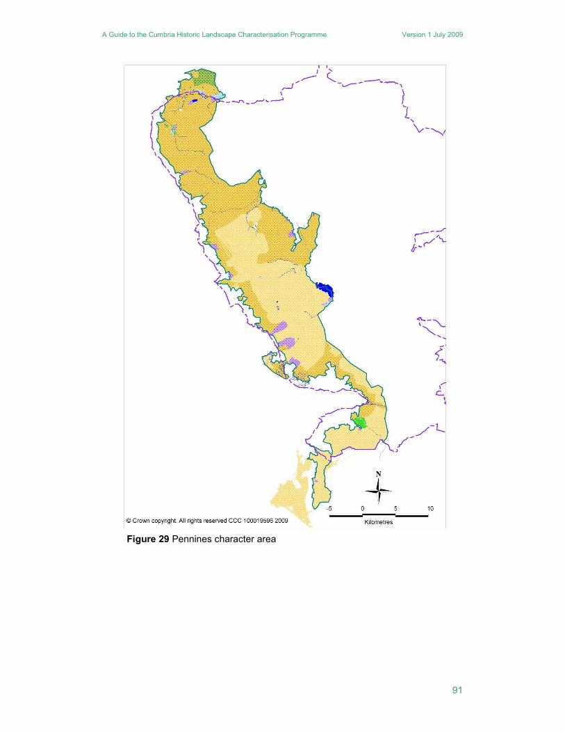
38. Sellafield
A small character area dominated totally by the modern industrial infrastructure associated with the former nuclear power stations and existing nuclear industries of Sellafield. The nucleated settlement of Seascale consists largely of modern housing estates established to accommodate Sellafield’s workforce. The only historic nucleation is Calder Bridge. The remainder of the settlement pattern consists of discrete settlements largely set within ancient enclosures though only 44% of these settlements were in existence by 1770. There are areas of planned enclosure within former common wastes as at Green Moor, Burnt Moor and Hallsenna Moor. The only significant area of woodland is the plantation at Lingbank, most other woodland takes the form of planted shelter belts. There are no areas of ancient woodland.
Legacy: A mixed pattern of modern and older settlements with a largely pre-modern enclosure pattern but in part overlain and dominated by developments of very recent origin, weak legibility of landscape elements of medieval origin.
Landscape designation and status: None.
Planning authority: Copeland District Council.
Figure 30 Sellafield character area
A Guide to the Cumbria Historic Landscape Characterisation Programme Version 1 July 2009
93
39. Skiddaw Range
An area of high, open fell surrounded by lowland, with Keswick and the Greta Valley to the south, wholly within the Lake District National Park. The area is made up of unenclosed land almost in its entirety, apart from a small area of intakes around Lonscale Fell in the south and the narrow Mosedale Valley to the east. The range includes two of the Lake District’s highest fells; Skiddaw and Blencathra, and the area was known for its copper and tungsten mines. In particular, the Carrock Fell Tungsten Mine is considered to be of national importance and is a scheduled ancient monument. The mines, which were distributed around the southern and western flanks of the range, are of limited extent in themselves, but their remains can be seen along a number of routes into the fells, and thus have a dramatic impact on the landscape.
Legacy: A largely uninhabited upland landscape of mainly pre-modern origins in which most settlements and enclosures originated before the late 18th century, strong legibility of landscape elements of medieval origin, strong survival of industrial remains.
Landscape designation and status: Wholly within the Lake District National Park.
Planning authority: LDNPA.
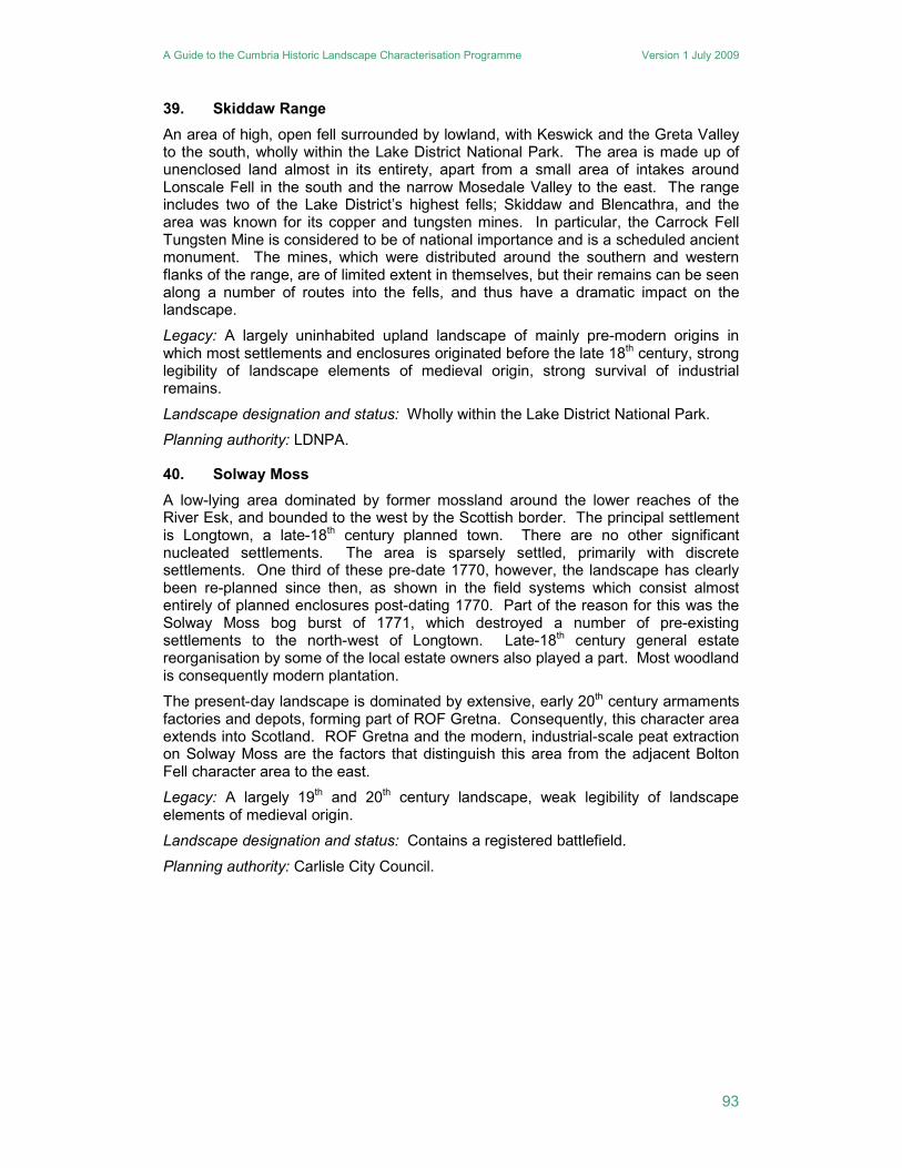
40. Solway Moss
A low-lying area dominated by former mossland around the lower reaches of the River Esk, and bounded to the west by the Scottish border. The principal settlement is Longtown, a late-18th century planned town. There are no other significant nucleated settlements. The area is sparsely settled, primarily with discrete settlements. One third of these pre-date 1770, however, the landscape has clearly been re-planned since then, as shown in the field systems which consist almost entirely of planned enclosures post-dating 1770. Part of the reason for this was the Solway Moss bog burst of 1771, which destroyed a number of pre-existing settlements to the north-west of Longtown. Late-18th century general estate reorganisation by some of the local estate owners also played a part. Most woodland is consequently modern plantation.
The present-day landscape is dominated by extensive, early 20th century armaments factories and depots, forming part of ROF Gretna. Consequently, this character area extends into Scotland. ROF Gretna and the modern, industrial-scale peat extraction on Solway Moss are the factors that distinguish this area from the adjacent Bolton Fell character area to the east.
Legacy: A largely 19th and 20th century landscape, weak legibility of landscape elements of medieval origin.
Landscape designation and status: Contains a registered battlefield.
Planning authority: Carlisle City Council.
A Guide to the Cumbria Historic Landscape Characterisation Programme Version 1 July 2009
94
Figure 31 Solway Moss character area
A Guide to the Cumbria Historic Landscape Characterisation Programme Version 1 July 2009
95
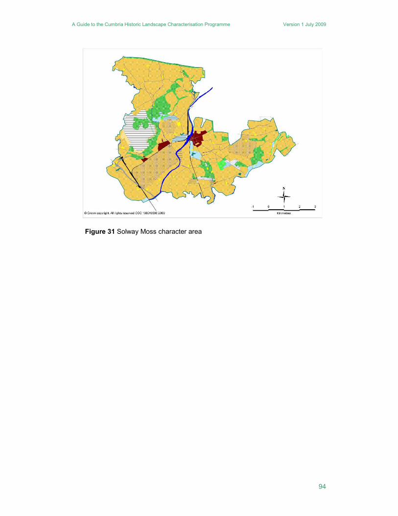
41. Solway Plain
A low lying area bounded by the coast to the north and west with extensive areas of sand, shingle, saltmarsh and mudflats. Much of the coastal zone lies within the Solway Coast AONB, apart from a small area around the town of Silloth. In terms of historic landscape character, the Solway Coast AONB is not distinct from the remainder of the Solway Plain character area. The area of the AONB broadly co-incides with the visual impact zone for the Hadrian’s Wall World Heritage Site. Hadrian’s Wall has some impact on the character of the area, as most of the Roman forts were later sites for medieval settlement. The settlement pattern is varied, with large and small nucleated settlements intermixed with many discrete farms scattered across the landscape. Two thirds of the discrete farms, however, post-date 1770, and many are related to the improvement and enclosure of the wastes. In contrast, most of the nucleated settlements are of medieval origin. One exception is Silloth, a 19th century planned settlement, which is the area’s only town. The older settlements are distributed within and around the edge of former common arable fields. Three quarters of the developed areas of nucleated settlements were in existence before 1770, and only 19% of the developed areas post-date 1900. Consequently, the settlement pattern is relatively traditional in comparison to some other character areas, it has a good degree of time depth and has been little altered by post-19th century development. In general, the character area retains a considerable discernible legacy from the Middle Ages in both its settlement pattern and field systems.
The area is dominated by former common arable fields, with extensive areas of 19th century planned enclosures in between. The planned enclosure is mainly in areas of drained mosslands, which is one of the key features of the area. Small patches of unimproved mossland survive, especially around Wedholme Flow. In recent times, peat cutting was a significant industry around Kirkbride, on Wedholme Flow and Bowness Common, and evidence of moss rooms survive. There are small areas of anciently enclosed land, mostly belonging to individual farms. This mix of older and 19th century planned enclosures is reflected in the road system, with numerous meandering lanes amongst the former common arable fields, and fewer, straighter roads across areas of planned fields. A key characteristic of more recent development is a number of former military airfields, at Cardunnock, Kirkbride, Silloth and Wiggonby. There is very little woodland, although field boundaries usually comprise hedgerows, both for more ancient and 19th century enclosures.
Legacy: A very traditional settlement pattern that largely pre-dates the 19th century with mixed enclosures of modern and earlier date, strong legibility of landscape elements of medieval origin.
Landscape designation and status: Northern coastal portion is mainly within the Solway Coast AONB, much of the same area includes part of the Hadrian’s Wall World Heritage Site and its setting.
Planning authorities: Allerdale Borough Council and Carlisle City Council.
A Guide to the Cumbria Historic Landscape Characterisation Programme Version 1 July 2009
96
Figure 32 Solway Plain character area
A Guide to the Cumbria Historic Landscape Characterisation Programme Version 1 July 2009
97
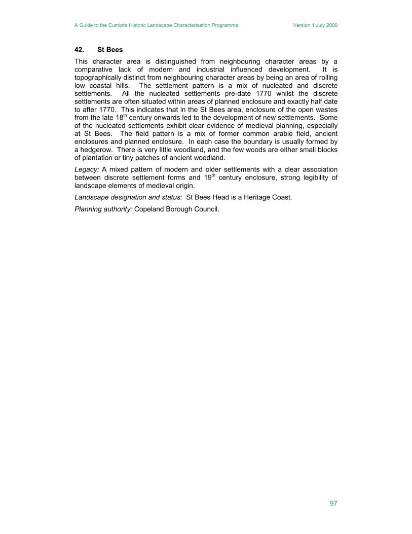
42. St Bees
This character area is distinguished from neighbouring character areas by a comparative lack of modern and industrial influenced development. It is topographically distinct from neighbouring character areas by being an area of rolling low coastal hills. The settlement pattern is a mix of nucleated and discrete settlements. All the nucleated settlements pre-date 1770 whilst the discrete settlements are often situated within areas of planned enclosure and exactly half date to after 1770. This indicates that in the St Bees area, enclosure of the open wastes from the late 18th century onwards led to the development of new settlements. Some of the nucleated settlements exhibit clear evidence of medieval planning, especially at St Bees. The field pattern is a mix of former common arable field, ancient enclosures and planned enclosure. In each case the boundary is usually formed by a hedgerow. There is very little woodland, and the few woods are either small blocks of plantation or tiny patches of ancient woodland.
Legacy: A mixed pattern of modern and older settlements with a clear association between discrete settlement forms and 19th century enclosure, strong legibility of landscape elements of medieval origin.
Landscape designation and status: St Bees Head is a Heritage Coast.
Planning authority: Copeland Borough Council.
A Guide to the Cumbria Historic Landscape Characterisation Programme Version 1 July 2009
98
Figure 33 St Bees character area
A Guide to the Cumbria Historic Landscape Characterisation Programme Version 1 July 2009
99
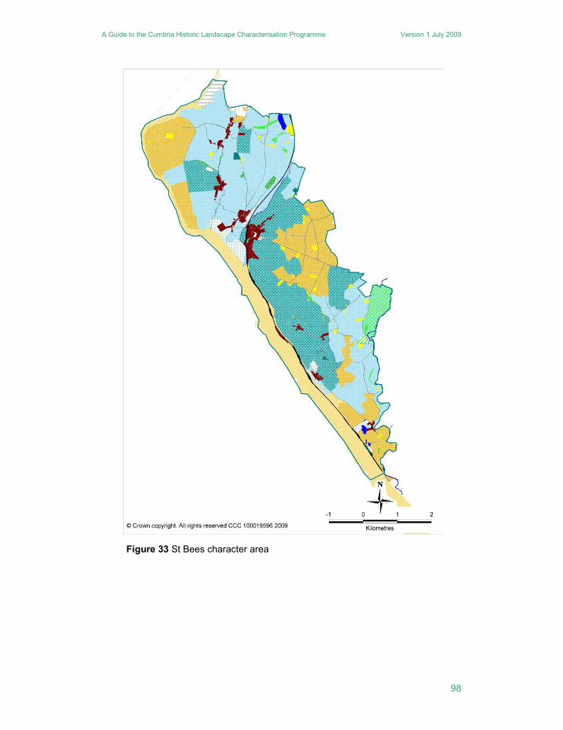
43. Stainmore
This is a small character area that gradually rises from the Eden Valley to the Pennine edge. It is dominated by the catchments of the River Belah and the Swindale Beck. Its settlement pattern is in marked contrast to the neighbouring Eden Valley, as it is almost exclusively dispersed with just a few small nucleations. Of the dispersed settlements, only 24% pre-date 1770, with the vast majority dating to the 19th century. Some of this is associated with enclosure of the common wastes, but much seems to relate to a general intensification of settlement in a quite sparsely settled area. The lack of nucleations goes hand in hand with a total lack of former common arable fields. The field systems are a mix of anciently enclosed land, including many intakes, and smaller patches of planned enclosures. In the Warcop area some of the settlements and field systems have been abandoned as they have been incorporated into a military training area. Most woodland is either ancient woodland, or replanted ancient woodland. There are some patches of fellside ancient woodland, such as Hellbeck Wood, but the majority is gill woodland which forms a significant component within the local landscape. Another characteristic local feature is extensive quarrying remains, much of which is now redundant, though the large Hartley quarry is still active.
Legacy: Largely modern settlement pattern but a mixed enclosure pattern, strong legibility of landscape elements of medieval origin with well preserved earthwork remains.
Landscape designation and status: Partly within the North Pennines AONB and the North Pennines European and Global Geopark.
Planning authority: Eden District Council.
A Guide to the Cumbria Historic Landscape Characterisation Programme Version 1 July 2009
100
Figure 34 Stainmore character area
A Guide to the Cumbria Historic Landscape Characterisation Programme Version 1 July 2009
101
44. Thirlmere
The area of Thirlmere forms a small but distinct character area, defined by the reservoir and its surrounding woodland. There are few settlements and all are discrete. One of these Legburthwaite, at the northern end of the reservoir, is a likely medieval assart in origin and is surrounded by a small area of ancient enclosures, which includes limited areas of ancient woodland. At the southern end of the reservoir a further area of ancient enclosures clusters around Wythburn, where the fields can clearly be seen to have been partially lost to the waters of the reservoir. Before the construction of the reservoir in the 1890s, Thirlmere comprised two small tarns, linked by a narrow neck of water. Around its shores was a narrow band of enclosures, with scattered farmsteads. Following the enlargement of the lake, large expanses of coniferous woodland were planted on the slopes surrounding it, to act as a filter for water running onto the lake. Most of the settlements were removed for the reservoir and the subsequent forestry. The Manchester Corporation, who were behind the construction of the reservoir in the late 19th century, attracted a great deal of criticism for the large expanses of coniferous plantation, which was considered gloomy and dark. The areas of original planting still survive, and indeed, have been extended, though are now subject to a programme of thinning and replacement with deciduous native species.
Legacy: A largely 19th and 20th century landscape dominated by forestry plantation and the reservoir, moderate legibility of landscape elements of medieval origin.
Landscape designation and status: Wholly within the Lake District National Park.
Planning authority: Lake District National Park.
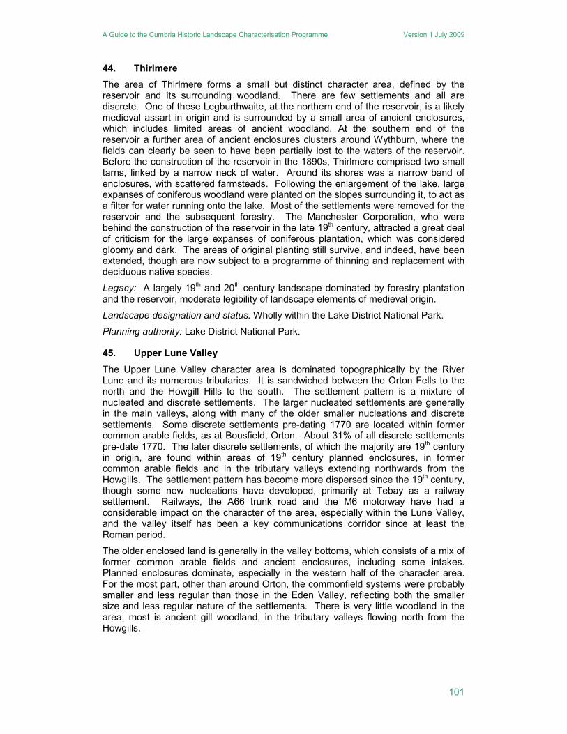
45. Upper Lune Valley
The Upper Lune Valley character area is dominated topographically by the River Lune and its numerous tributaries. It is sandwiched between the Orton Fells to the north and the Howgill Hills to the south. The settlement pattern is a mixture of nucleated and discrete settlements. The larger nucleated settlements are generally in the main valleys, along with many of the older smaller nucleations and discrete settlements. Some discrete settlements pre-dating 1770 are located within former common arable fields, as at Bousfield, Orton. About 31% of all discrete settlements pre-date 1770. The later discrete settlements, of which the majority are 19th century in origin, are found within areas of 19th century planned enclosures, in former common arable fields and in the tributary valleys extending northwards from the Howgills. The settlement pattern has become more dispersed since the 19th century, though some new nucleations have developed, primarily at Tebay as a railway settlement. Railways, the A66 trunk road and the M6 motorway have had a considerable impact on the character of the area, especially within the Lune Valley, and the valley itself has been a key communications corridor since at least the Roman period.
The older enclosed land is generally in the valley bottoms, which consists of a mix of former common arable fields and ancient enclosures, including some intakes. Planned enclosures dominate, especially in the western half of the character area. For the most part, other than around Orton, the commonfield systems were probably smaller and less regular than those in the Eden Valley, reflecting both the smaller size and less regular nature of the settlements. There is very little woodland in the area, most is ancient gill woodland, in the tributary valleys flowing north from the Howgills.
A Guide to the Cumbria Historic Landscape Characterisation Programme Version 1 July 2009
102
Legacy: A mixed pattern of modern and older settlements and field enclosure, but with a slight predominance of modern forms, strong legibility of landscape elements of medieval origin.
Landscape designation and status: None.
Planning authority: Eden District Council
Figure 35 Upper Lune Valley character area
A Guide to the Cumbria Historic Landscape Characterisation Programme Version 1 July 2009
103
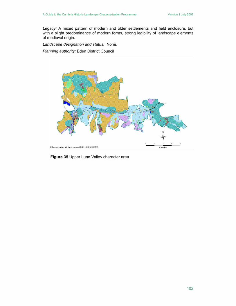
46. Walney Island
As an island, Walney forms its own character area and the smallest character area in Cumbria. It is connected via a bridge to Barrow and its development has been strongly influenced by the growth of Barrow. Its landscape is dominated by the urban sprawl of Vickerstown and North Walney which grew in the 20th century mainly; in part as a resort but primarily as accommodation for the workforce of Vickers on Barrow Island. This settlement and the construction to its north of Walney Airport and a golf course ensure that the landscape character of the northern part of the island is essentially modern. The southern half of the island is less influenced by modern developments and contains one nucleated settlement of medieval origin, Biggar. This was one of three nucleated settlements on Walney with the other two having been engulfed by urban development. The enclosed farmland is all enclosed former common arable. There is no woodland on Walney and indeed very few trees.
Legacy: A predominately modern settlement pattern with older elements of field enclosure, moderate legibility of landscape elements of medieval origin.
Landscape designation and status: None.
Planning authority: Barrow Borough Council.
A Guide to the Cumbria Historic Landscape Characterisation Programme Version 1 July 2009
104
Figure 36 Walney Island character area
A Guide to the Cumbria Historic Landscape Characterisation Programme Version 1 July 2009
105
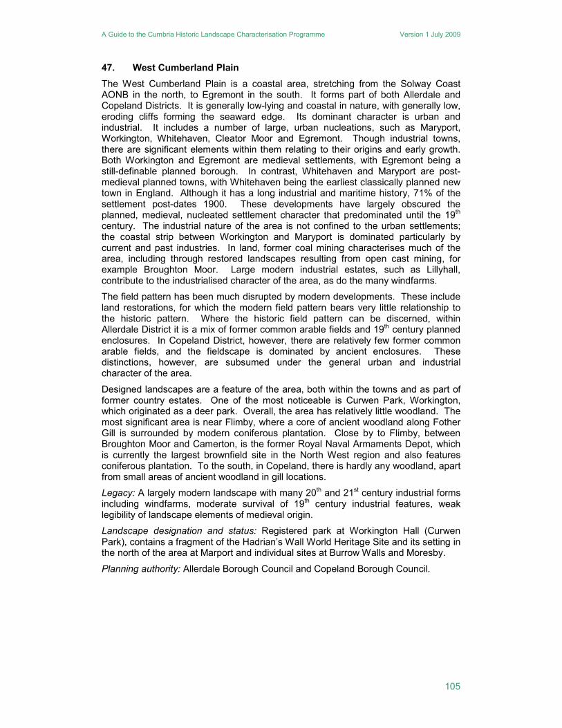
47. West Cumberland Plain
The West Cumberland Plain is a coastal area, stretching from the Solway Coast AONB in the north, to Egremont in the south. It forms part of both Allerdale and Copeland Districts. It is generally low-lying and coastal in nature, with generally low, eroding cliffs forming the seaward edge. Its dominant character is urban and industrial. It includes a number of large, urban nucleations, such as Maryport, Workington, Whitehaven, Cleator Moor and Egremont. Though industrial towns, there are significant elements within them relating to their origins and early growth. Both Workington and Egremont are medieval settlements, with Egremont being a still-definable planned borough. In contrast, Whitehaven and Maryport are post-medieval planned towns, with Whitehaven being the earliest classically planned new town in England. Although it has a long industrial and maritime history, 71% of the settlement post-dates 1900. These developments have largely obscured the planned, medieval, nucleated settlement character that predominated until the 19th century. The industrial nature of the area is not confined to the urban settlements; the coastal strip between Workington and Maryport is dominated particularly by current and past industries. In land, former coal mining characterises much of the area, including through restored landscapes resulting from open cast mining, for example Broughton Moor. Large modern industrial estates, such as Lillyhall, contribute to the industrialised character of the area, as do the many windfarms.
The field pattern has been much disrupted by modern developments. These include land restorations, for which the modern field pattern bears very little relationship to the historic pattern. Where the historic field pattern can be discerned, within Allerdale District it is a mix of former common arable fields and 19th century planned enclosures. In Copeland District, however, there are relatively few former common arable fields, and the fieldscape is dominated by ancient enclosures. These distinctions, however, are subsumed under the general urban and industrial character of the area.
Designed landscapes are a feature of the area, both within the towns and as part of former country estates. One of the most noticeable is Curwen Park, Workington, which originated as a deer park. Overall, the area has relatively little woodland. The most significant area is near Flimby, where a core of ancient woodland along Fother Gill is surrounded by modern coniferous plantation. Close by to Flimby, between Broughton Moor and Camerton, is the former Royal Naval Armaments Depot, which is currently the largest brownfield site in the North West region and also features coniferous plantation. To the south, in Copeland, there is hardly any woodland, apart from small areas of ancient woodland in gill locations.
Legacy: A largely modern landscape with many 20th and 21st century industrial forms including windfarms, moderate survival of 19th century industrial features, weak legibility of landscape elements of medieval origin.
Landscape designation and status: Registered park at Workington Hall (Curwen Park), contains a fragment of the Hadrian’s Wall World Heritage Site and its setting in the north of the area at Marport and individual sites at Burrow Walls and Moresby.
Planning authority: Allerdale Borough Council and Copeland Borough Council.
A Guide to the Cumbria Historic Landscape Characterisation Programme Version 1 July 2009
106
Figure 37 West Cumberland Plain character area
A Guide to the Cumbria Historic Landscape Characterisation Programme Version 1 July 2009
107
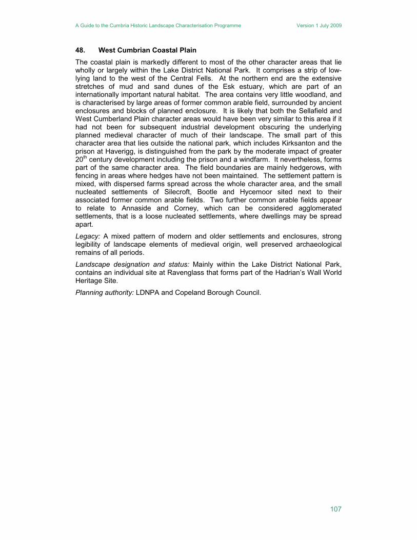
48. West Cumbrian Coastal Plain
The coastal plain is markedly different to most of the other character areas that lie wholly or largely within the Lake District National Park. It comprises a strip of low-lying land to the west of the Central Fells. At the northern end are the extensive stretches of mud and sand dunes of the Esk estuary, which are part of an internationally important natural habitat. The area contains very little woodland, and is characterised by large areas of former common arable field, surrounded by ancient enclosures and blocks of planned enclosure. It is likely that both the Sellafield and West Cumberland Plain character areas would have been very similar to this area if it had not been for subsequent industrial development obscuring the underlying planned medieval character of much of their landscape. The small part of this character area that lies outside the national park, which includes Kirksanton and the prison at Haverigg, is distinguished from the park by the moderate impact of greater 20th century development including the prison and a windfarm. It nevertheless, forms part of the same character area. The field boundaries are mainly hedgerows, with fencing in areas where hedges have not been maintained. The settlement pattern is mixed, with dispersed farms spread across the whole character area, and the small nucleated settlements of Silecroft, Bootle and Hycemoor sited next to their associated former common arable fields. Two further common arable fields appear to relate to Annaside and Corney, which can be considered agglomerated settlements, that is a loose nucleated settlements, where dwellings may be spread apart.
Legacy: A mixed pattern of modern and older settlements and enclosures, strong legibility of landscape elements of medieval origin, well preserved archaeological remains of all periods.
Landscape designation and status: Mainly within the Lake District National Park, contains an individual site at Ravenglass that forms part of the Hadrian’s Wall World Heritage Site.
Planning authority: LDNPA and Copeland Borough Council.
A Guide to the Cumbria Historic Landscape Characterisation Programme Version 1 July 2009
108
Figure 38 West Cumbria Coastal Plain character area (outside the Lake
District National Park)
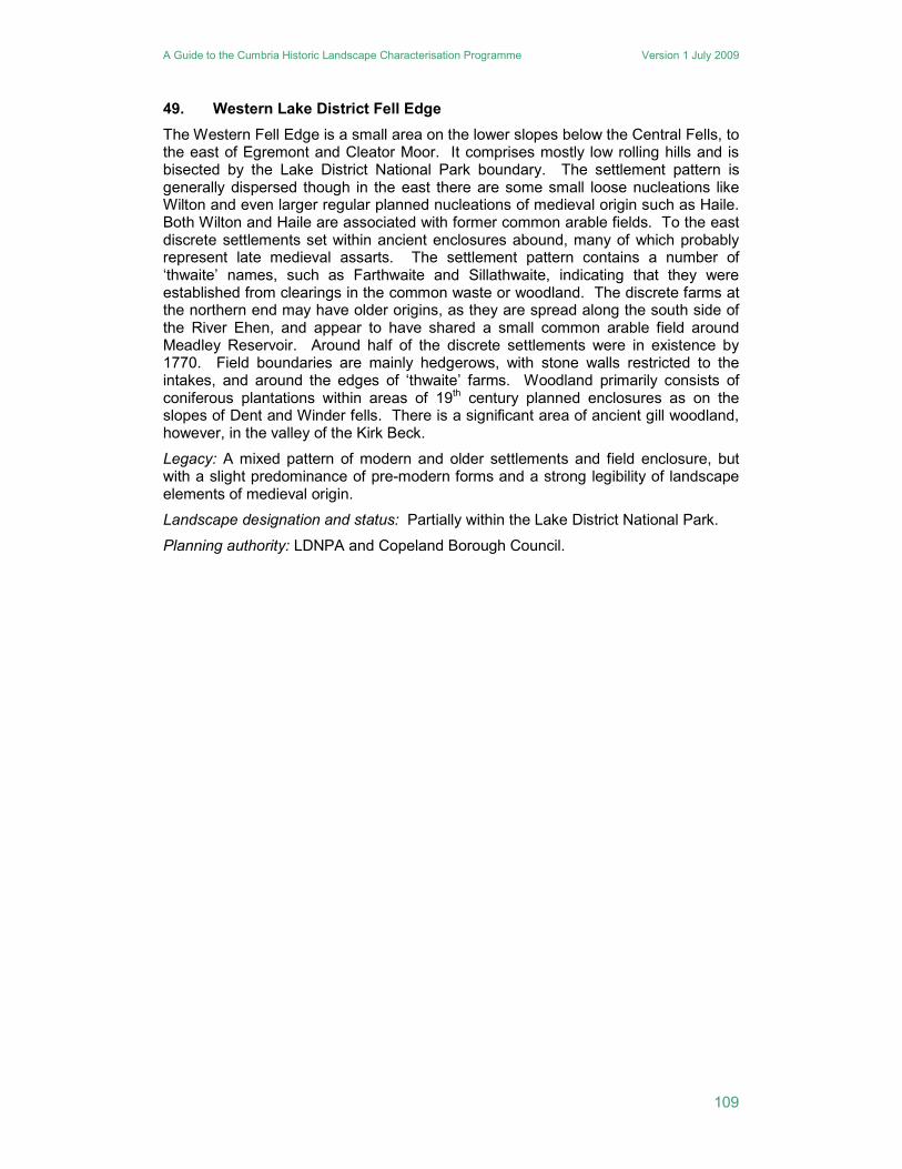
A Guide to the Cumbria Historic Landscape Characterisation Programme Version 1 July 2009
109
49. Western Lake District Fell Edge
The Western Fell Edge is a small area on the lower slopes below the Central Fells, to the east of Egremont and Cleator Moor. It comprises mostly low rolling hills and is bisected by the Lake District National Park boundary. The settlement pattern is generally dispersed though in the east there are some small loose nucleations like Wilton and even larger regular planned nucleations of medieval origin such as Haile. Both Wilton and Haile are associated with former common arable fields. To the east discrete settlements set within ancient enclosures abound, many of which probably represent late medieval assarts. The settlement pattern contains a number of ‘thwaite’ names, such as Farthwaite and Sillathwaite, indicating that they were established from clearings in the common waste or woodland. The discrete farms at the northern end may have older origins, as they are spread along the south side of the River Ehen, and appear to have shared a small common arable field around Meadley Reservoir. Around half of the discrete settlements were in existence by 1770. Field boundaries are mainly hedgerows, with stone walls restricted to the intakes, and around the edges of ‘thwaite’ farms. Woodland primarily consists of coniferous plantations within areas of 19th century planned enclosures as on the slopes of Dent and Winder fells. There is a significant area of ancient gill woodland, however, in the valley of the Kirk Beck.
Legacy: A mixed pattern of modern and older settlements and field enclosure, but with a slight predominance of pre-modern forms and a strong legibility of landscape elements of medieval origin.
Landscape designation and status: Partially within the Lake District National Park.
Planning authority: LDNPA and Copeland Borough Council.
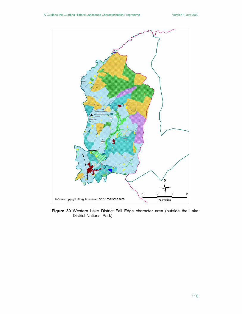
A Guide to the Cumbria Historic Landscape Characterisation Programme Version 1 July 2009
110
Figure 39 Western Lake District Fell Edge character area (outside the Lake District National Park)
A Guide to the Cumbria Historic Landscape Characterisation Programme Version 1 July 2009
111
50. Westlinton
To the north of Carlisle, this area of gently rolling, low-lying topography is quite sparsely populated, and is superficially similar to the Inglewood character area. It includes the course of the Hadrian’s Wall World Heritage Site, but this has no discernible impact on the character of the landscape. It has a patchwork mix of field systems and settlement types. The dominant settlement form is discrete, and most nucleations are small. Around 34% of the discrete settlements pre-date 1770. The remainder of the discrete settlements (45% of the total) relate largely to the enclosure and improvement of the unenclosed wastes in the 19th century. Around a third of all the nucleated and small nucleated settlements pre-date 1770 in origin, but only Irthington exhibits any evidence of medieval planning. The remainder of the settlements originated in the 19th century. Despite the relatively recent origin of much of the nucleated settlement pattern, only 29% of the total area of all nucleation post dates 1900.
The field pattern is dominated by a combination of planned enclosures and ancient enclosures. Former common arable fields are scattered throughout, but are generally small. The planned enclosures are concentrated in areas of former low moorland and moss, but around the Brampton to Longtown road there are planned enclosures associated with pre-1770 discrete settlements. Woodland is largely modern plantation, and focused in the areas of planned enclosure on former mossland, for example at Scaleby Moss and Todhills. The only ancient woodland within the character area is along the Hether Burn in the north-eastern corner of the character area. Despite the area’s proximity to Carlisle, and the inclusion within it of Carlisle Airport, the area is overwhelmingly rural in character.
Legacy: A mixed pattern of modern and older settlements and field enclosure, but with a slight predominance of 19th century forms, moderate legibility of landscape elements of medieval origin.
Landscape designation and status: Contains part of the Hadrian’s Wall World Heritage Site and its setting.
Planning authority: Carlisle City Council.
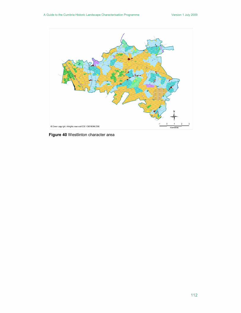
A Guide to the Cumbria Historic Landscape Characterisation Programme Version 1 July 2009
112
Figure 40 Westlinton character area
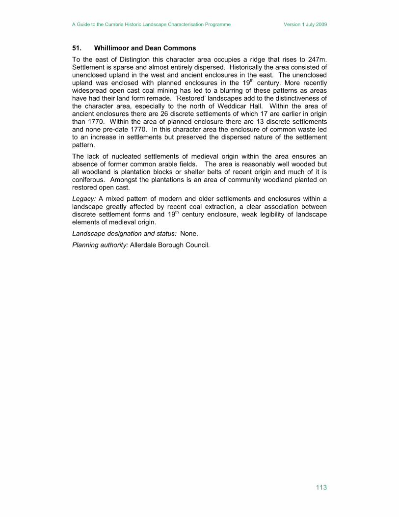
A Guide to the Cumbria Historic Landscape Characterisation Programme Version 1 July 2009
113
51. Whillimoor and Dean Commons
To the east of Distington this character area occupies a ridge that rises to 247m. Settlement is sparse and almost entirely dispersed. Historically the area consisted of unenclosed upland in the west and ancient enclosures in the east. The unenclosed upland was enclosed with planned enclosures in the 19th century. More recently widespread open cast coal mining has led to a blurring of these patterns as areas have had their land form remade. ‘Restored’ landscapes add to the distinctiveness of the character area, especially to the north of Weddicar Hall. Within the area of ancient enclosures there are 26 discrete settlements of which 17 are earlier in origin than 1770. Within the area of planned enclosure there are 13 discrete settlements and none pre-date 1770. In this character area the enclosure of common waste led to an increase in settlements but preserved the dispersed nature of the settlement pattern.
The lack of nucleated settlements of medieval origin within the area ensures an absence of former common arable fields. The area is reasonably well wooded but all woodland is plantation blocks or shelter belts of recent origin and much of it is coniferous. Amongst the plantations is an area of community woodland planted on restored open cast.
Legacy: A mixed pattern of modern and older settlements and enclosures within a landscape greatly affected by recent coal extraction, a clear association between discrete settlement forms and 19th century enclosure, weak legibility of landscape elements of medieval origin.
Landscape designation and status: None.
Planning authority: Allerdale Borough Council.
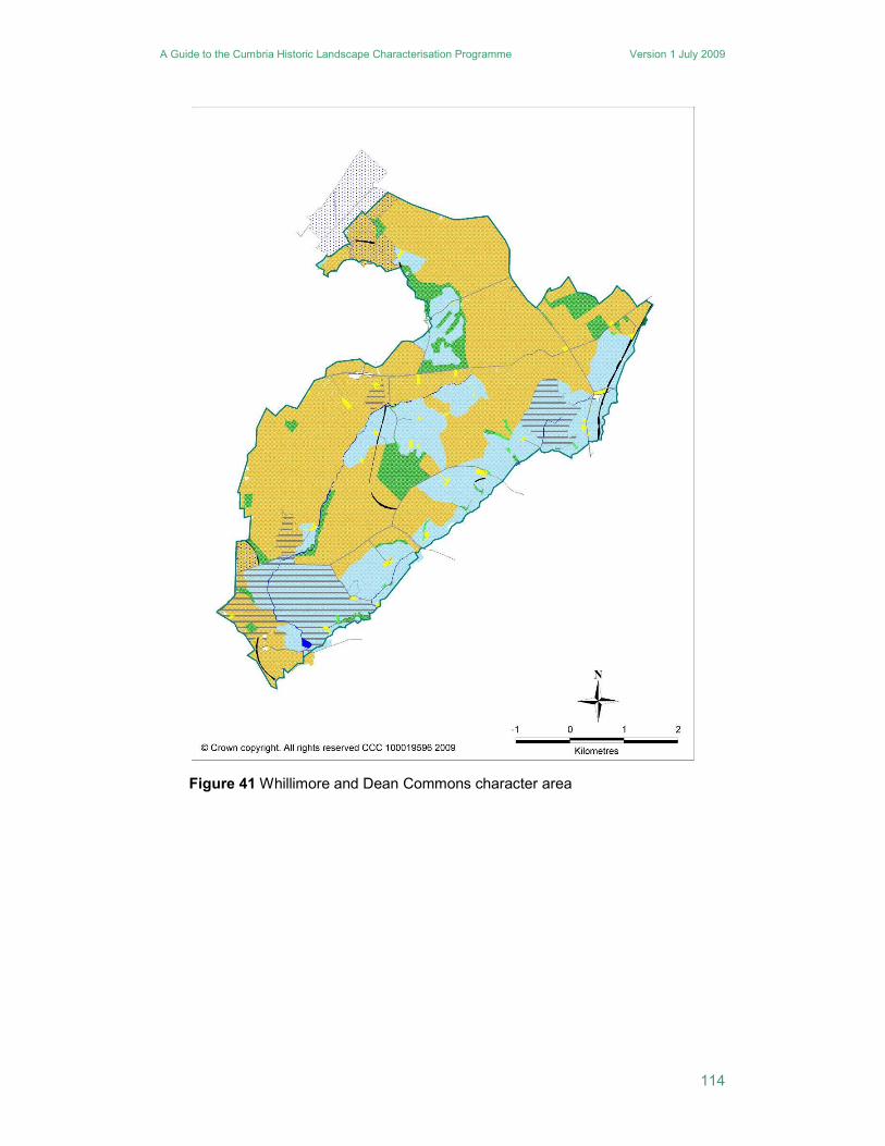
A Guide to the Cumbria Historic Landscape Characterisation Programme Version 1 July 2009
114
Figure 41 Whillimore and Dean Commons character area
A Guide to the Cumbria Historic Landscape Characterisation Programme Version 1 July 2009
115
52. Windermere, and the Rothay and Brathay Valleys
This long, narrow character area follows the valleys of the Rivers Rothay and Brathay, and extends down the eastern shore of Lake Windermere. It contains the largest area of urban development, including Bowness, Windermere, Ambleside and Grasmere. The built-up character is a reflection of this area’s status as one of the key destinations for visitors to the Lake District, and it contains a number of hotels, holiday cottages and other places to stay. Both within the urban areas, and along the A590 Kendal to Keswick road which runs through the area, are a large number of villas and country houses, many with extensive landscaped gardens. It is well wooded, and many of the trees are exotic species, introduced for the landscape value. The northern part of the area is less developed, and north of Ambleside the landscape is more rural in character. Even here, however, there are popular visitor attractions, such as the village of Grasmere, and Wordsworth’s homes at Dove Cottage and Rydal Mount, as well as the smaller water bodies of Rydal Water and Grasmere.
Legacy: A predominantly modern settlement structure with a mixed pattern of enclosure and woodland, weak legibility of landscape elements of medieval origin, strong influence of 18th and 19th century landscape aesthetics.
Landscape designation and status: Wholly within the Lake District National Park, registered park and gardens at Belle Isle, Blackwell, Brockhole, Rydal Hall and Rydal Mount.
Planning authority: LDNPA.
53. Wythop and Thornthwaite Forest
South of the North Western Lowlands, and north of the Central Fells is a small area of upland which would have formed the common waste to the low lands of Bassenthwaite and Lorton Vale. This area was enclosed systematically in the late eighteenth or early nineteenth century, although it also contains small areas of intakes. There is also a small area of lower lying land around Wythop Mill, which is anciently enclosed. One of its main characteristics, however, is the large area of coniferous woodland plantation, which was begun in the 19th century, but greatly extended by the Forestry Commission in the 20th century. Like Grizedale, this is now a forest park with large areas accessible to the public. . The areas of unwooded fell are divided by stone walls into very large, irregular enclosures.
Legacy: A largely 19th and 20th century landscape dominated by forestry plantation, weak legibility of landscape elements of medieval origin.
Landscape designation and status: Wholly within the Lake District National Park.
Planning authority: LDNPA.

A Guide to the Cumbria Historic Landscape Characterisation Programme Version 1 July 2009
116
A Guide to the Cumbria Historic Landscape Characterisation Database Version 1 July 2009
117
APPENDIX 4: A GUIDE TO PLANNING POLICY AND GUIDANCE RELEVANT TO THE HISTORIC LANDSCAPE
A useful summary of relevant guidance linked to all the relevant documents is available at http://www.naturalengland.org.uk/ourwork/landscape/englands/character/regulations.aspx . Only those aspects of guidance and policy are noted that relate directly to the historic landscape or have had or are likely to have a profound influence upon its future evolution.
PPG 15 Planning and the Historic Environment 1994
Explains the role of the planning system in the protection of historic buildings, conservation areas and other aspects of the historic environment. A number of important concepts are articulated in this guidance:
• that the historic environment does not consist of a collection of individual sites and monuments but is all-pervasive and hence cannot remain unchanging
• that it contributes strongly to local character and thus a sense of place
• that as part of sustainable development the value of the historic environment to present and future generations needs to be given due weight in the planning process
• that the special and valued aspects of the local character of the historic environment need to be identified and the historic environment’s capacity for change needs to be assessed through the spatial planning system.
The role of development plans in maintaining the overall historic character of the landscape is emphasised, it is stressed that specific policies for World Heritage Sites should be incorporated into development plans and the idea of Registered Parks and Gardens and Registered Battlefields is highlighted.
PPG 16 Archaeology and Planning 1990
Explains how archaeological remains, including monuments within the landscape, should be preserved or recorded both in an urban setting and in the countryside. It provides advice on the handling of archaeological remains through the planning process, including on the weight to be given to them in planning decisions and on the use of planning conditions. Although largely site- rather than landscape-based, there is an understanding that archaeological remains contribute to the character of the landscape. The desirability of preserving ancient monuments within their settings is highlighted as a material consideration in determining planning applications, irrespective of whether the monument is scheduled or unscheduled.
PPS 1 Delivering Sustainable Development 2005
Sets out the Government's overarching planning policies on the delivery of sustainable development through the planning system. Regional planning bodies and local planning authorities should ensure that development plans promote outcomes in which environmental, economic and social objectives are achieved together over time. This includes a commitment to protect and enhance the quality of the historic environment. It advises that development plan policies should take account of the protection of the wider countryside and the impact of development on landscape quality and the preservation and enhancement of the built and archaeological heritage. Consequently, it promotes the view that within the planning process where design fails to take the opportunities available for improving the character and quality of an area such design should not be accepted. PPS: Planning and Climate Change - Supplement to PPS 1 2007
Recognises the planning system as having a key role in helping to tackle the impacts of climate change, including through:
• shaping sustainable communities so that they are resilient to climate change
• conserving and enhancing biodiversity by recognising the impact of climate change on habitat distribution.

A Guide to the Cumbria Historic Landscape Characterisation Database Version 1 July 2009
118
PPS 7 Sustainable Development in Rural Areas 2004
Sets out the Government's planning policies for rural areas, including country towns and villages and the wider, largely undeveloped countryside up to the fringes of larger urban areas. Objectives include raising the quality of the rural environment through the promotion of;
• the sustainability of local environments and neighbourhoods
• good quality, sustainable development that respects and, where possible, enhances local distinctiveness and the intrinsic qualities of the countryside
• continued protection of the open countryside for the benefit of all, with the highest level of protection for our most valued landscapes.
It seeks to achieve these objectives by focusing most development in, or next to, existing towns and villages; by preventing urban sprawl and discouraging the development of 'greenfield' land. It also seeks to promote sustainable, diverse and adaptable agriculture sectors where valued landscapes and biodiversity are managed through farming.
PPS 9 Biological and Geological Conservation 2005
Sets out planning policies on geological conservation and for the protection of biodiversity through the planning system. The importance of ancient woodland is noted, whether or not the woodland has statutory protection, and encouragement is given to use the planning system to avoid loss or deterioration. Of particular note is the recommendation that Local Development Frameworks should include appropriate policies to encourage the restoration or creation of new priority habitats and should identify areas or sites for restoration or creation.
PPS 22 Renewable Energy 2004
Presents national policies for those aspects of land use planning in England that relate to the development of on-shore renewable energy. The key principles include:
• a commitment that renewable energy developments should be accommodated throughout England in locations where the technology is viable and environmental, economic, and social impacts can be addressed satisfactorily.
• a requirement that development proposals should demonstrate how any environmental impacts have been minimised through careful consideration of location, scale, design and other measures.
The landscape and visual effects of particular renewable energy developments are recognised as a cause for concern and it is noted that they will vary on a case by case basis according to the type of development, its location and the landscape setting of the proposed development. It is recommended that impacts are minimised through appropriate siting, design and landscaping schemes, depending on the size and type of development proposed. It is noted that of all renewable technologies, wind turbines are likely to have the greatest visual and landscape effects. Even so, local authorities are urged to recognise that the impact of turbines on the landscape varies according to the size and number of turbines and the type of landscape involved, and that such impacts are temporary if conditions are attached to planning permissions which require the future decommissioning of turbines. Planning authorities are also required to take account of the cumulative impact of wind generation projects in particular areas.
Areas of landscape protected by international and national designations are not exempt from potential renewable energy developments. Planning permission for renewable energy developments affecting a site of international importance for nature and/or heritage conservation should only be granted where the integrity of the site would not be adversely affected, unless a case can be made that there is no alternative solution and there are imperative reasons of overriding public interest. In sites with nationally recognised designations planning permission for renewable energy projects should only be granted where it can be demonstrated that the objectives of designation of the area will not be compromised by the development. Where there are significant adverse effects on the qualities for which the area has been designated permission can only be granted where these are clearly outweighed by the environmental, social and economic benefits. It is recommended that small-scale developments
A Guide to the Cumbria Historic Landscape Characterisation Database Version 1 July 2009
119
should be permitted within areas such as National Parks, Areas of Outstanding Natural Beauty and Heritage Coasts provided that there is no significant environmental detriment to the area concerned.
Good Practice Guide on Planning for Tourism 2007
Highlights tourism, in all its forms, as being of crucial importance to economic, social and
environmental well-being. The environment is noted as being a key asset to encourage
tourism. At the same time the economic benefits of tourism in particular are recognised as
being able to help sustain and improve both the natural and built physical environment. It
recognises that visitors to historic buildings, archaeological sites and landscapes can provide
income or voluntary efforts which help maintain and conserve such assets. It further notes that
in devising good policies for tourism, planners need to understand and often reconcile a number
of important factors including environmental impacts upon historic settings and landscape
quality.
North West Regional Spatial Strategy 2007
Policy EM1 advocates that where development proposals affect the landscape, natural or historic environment or woodland assets, developers and planning authorities should first seek to avoid loss or damage to such assets. Policy EM1 (A) states that plans, strategies, proposals and schemes should identify, protect, maintain, and enhance natural, historic and other distinctive features that contribute to the character of landscapes. Policy EM1 (C) states that plans, strategies, proposals and schemes should protect, conserve and enhance the historic environment and seek to exploit the regeneration potential of Cumbria’s rural villages and market towns and of the Lake District’s cultural landscape. Policy EM1 (D) advocates that plans, strategies, proposals and schemes should identify and protect ancient semi-natural woodland.

A Guide to the Cumbria Historic Landscape Characterisation Database Version 1 July 2009
120
A Guide to the Cumbria Historic Landscape Characterisation Database Version 1 July 2009
121
APPENDIX 5: A GUIDE TO LEGISLATION AND SITE DESIGNATIONS RELEVANT TO THE HISTORIC LANDSCAPE
The European Landscape Convention
The European Landscape Convention - also known as the Florence Convention, after the city where the convention was adopted in 2000 - promotes the protection, management and planning of European landscapes and organises European co-operation on landscape issues. It is the first international treaty to be exclusively concerned with all dimensions of European landscape and views the landscape as a shared living natural and cultural heritage. The European Landscape Convention introduced the concept of "landscape quality objectives" into the protection, management and planning of geographical areas.
Ramsar Convention
The Ramsar Convention adopted in Ramsar (Iran) in 1971 is more fully known as the Convention on Wetlands of International Importance. It is a worldwide intergovernmental treaty which provides the framework for local and national action and international cooperation for the conservation and wise use of wetlands and their resources, as a contribution towards achieving sustainable development.
National Parks and Access to the Countryside Act 1949
Provided the framework for the creation of National Parks and Areas of Outstanding Natural Beauty in England and Wales, and also addressed public rights of way and access to open land. It further conferred new powers on local authorities for preserving and enhancing natural beauty. Subsequently substantially amended through the CROW Act 2000.
Commons Registration Act 1965
Established the registration of all common land, town and village greens, the ownerships of common land and rights of commons as a statutory duty for appropriate public bodies. It defined common land as not only land subject to rights of common but also being the waste land of a manor not subject to rights of common. As yet has not been superseded by the 2006 Act in all its provisions.
Countryside Act 1968
Conferred further powers on local authorities to preserve and enhance natural beauty over and above those defined under the 1949 act. Its emphases, however was less on conservation and more on recreation and access and provided an impetus to the opening up of land in public ownership. Public bodies were enjoined to have regard to the desirability of conserving the countryside’s natural beauty and amenity value, along with having due regard for resource production, economic and social issues within rural areas. Subsequently substantially amended through the Wildlife and Countryside Act 1981, CROW Act 2000 and NERC Act 2006.
Ancient Monuments and Archaeological Areas Act 1979 (as amended 2002)
Replaced previous legislation relating to the definition and protection of scheduled ancient monuments. Damage to a scheduled ancient monument is a criminal offence and any works taking place within one requires Scheduled Monument Consent from the Secretary of State. The Act introduced the concept of Areas of Archaeological Interest. Only five such areas were ever subsequently designated and the designation was not regarded as successful or useful and is no longer considered a valid means of heritage protection.
Wildlife and Countryside Act 1981
Addressed the issue of conserving biodiversity and geodiversity throughout the countryside. Provided national protection for SSSIs and introduced the use of Limestone Pavement Orders
A Guide to the Cumbria Historic Landscape Characterisation Database Version 1 July 2009
122
to protect areas of limestone pavement. Subsequently amended through the CROW Act 2000 and the NERC Act 2006.
Planning (Listed Buildings and Conservation Areas) Act 1990 (as amended 2008) Largely consolidated pre-existing legislation relating to buildings or areas of special architectural interest and strengthened local authority powers to safeguard conservation areas. Under the act a local planning authority is required to determine from time to time which parts of their district are locations of special architectural or historic interest, the character or appearance of which it is desirable to preserve or enhance, and to designate those locations as conservation areas.
Town and Country Planning Act 1990
Largely consolidated pre-existing legislation relating to town and country planning. Section 106 of the Act, in conjunction with DoE Circular 5/05, allows for local planning authorities and persons interested in land to agree, arrangements, restrictions or contributions as ‘planning agreements’ or ‘obligations’, that must be met should a planning application progress. They are usually undertaken to meet local planning requirements or priorities.
Hedgerow Regulations 1997
Enabled the protection of hedgerows for both their historical and ecological value. Any landowner who wishes to remove a hedgerow, if it is not exempt must serve a Hedgerow Removal Notice in writing on their local planning authority. Within an agreed period the authority must determine whether or not the hedge is considered 'important' under the regulations, and if so, whether or not to issue a Hedgerow Retention Notice or impose mitigatory conditions. An important hedgerow in terms of the historic landscape is one which marks the boundary of a historic parish or township existing before 1850, marks the boundary of or lies within a pre-1600 manorial demesne or estate, contains or is part of an archaeological feature noted on the Historic Environment Record or is a part of or associated with a field system predating the Inclosure Acts.
Countryside and Rights of Way Act 2000
Provided a new right of access on foot to areas of open land comprising mountain (land over 600 metres), moorland, heath, downland and Registered common land. Local authorities were given a duty to have regard to the purpose of conserving and enhancing the natural beauty of AONBs and those local authorities in whose areas AONBs are located were required to prepare and publish a management plan for the area.
Commons Act 2006
Part 1 of the Commons Act 2006 provides for the review, updating and future maintenance of the commons registers. As part of this process, applications to register land as common that failed under the 1965 Commons Registration Act may in certain cases be reconsidered. The overall purpose of the 2006 Act, however, is to protect all commons for the benefit of future generations, ensuring that they are managed sustainably to produce benefits for farming, public access and biodiversity. .Still in the process of gradual implementation.
Natural Environment and Rural Communities Act 2006
Places a duty on all local authorities to conserve wider biodiversity beyond those certain sites and species afforded statutory protection. Conserving biodiversity is considered to include habitat restoration or enhancement.
Circular on the Protection of World Heritage Sites 2009
The circular advises that local planning authorities must consider how to reflect international and national policies for protecting World Heritage Sites in their strategies and have special
A Guide to the Cumbria Historic Landscape Characterisation Database Version 1 July 2009
123
regard for them when devising site-specific proposals that impact upon a World Heritage Site and its setting including any buffer zone. Local planning authorities are expected to protect a World Heritage Site and its setting from inappropriate development and even from minor changes if they are likely to have a cumulative effect.
Town and Country Planning (Consultation) (England) Direction 2009
This circular and direction introduced a new requirement on local planning authorities to refer applications where they are minded to grant planning permission in circumstances where English Heritage have objected because the proposed development could have an adverse impact on the outstanding universal value, integrity, authenticity and significance of a World Heritage Site. The requirement covers the setting of a World Heritage Site, including any buffer zone or its equivalent.
Registered Common Land
Registered common land relates to all the land which was registered under the Commons Act 1965, and which is shown as such in the registers held by the commons registration authorities. Some common land, however, was exempted from registration under the Act, and so is not registered as such, even though it is widely recognised as common land today. In general terms, though not defined as such in the 1965 Act or any other legislation, common land is land owned by one person over which another person is entitled to exercise rights of common (such as grazing animals or cutting bracken for livestock bedding), and these rights are generally exercisable in common with others. There are 655 registered commons in Cumbria, covering 112,856 hectares of land.
Registered Town or Village Green
Town and Village Greens developed under customary law as areas of land where local people indulged in lawful sports and pastimes. They were registered originally under the provisions of the Commons Act 1965 and new town and village greens continue to be registered under the Commons Act 2006. Section 15 of the Commons Act 2006 changed the legal definition of a town or village green and sets out the qualifying circumstances in which land may be newly registered. Essentially anyone can apply to have land registered as a green if it has been used by local people for recreation ‘as of right’ (i.e. without permission, force or secrecy) for at least 20 years. There are 207 town or village greens in Cumbria.
National Park
National Parks are large areas of the countryside that are protected to ensure the conservation and enhancement of their special qualities. They are designated under the National Parks and Access to the Countryside Act 1949 by Natural England in recognition of their natural beauty and opportunities for open-air recreation. There are two national parks that are wholly or partly within Cumbria.
Area of Outstanding Natural Beauty
These are fine landscapes, of great variety in character and extent, protected to ensure the conservation and enhancement of their natural beauty. Although the criterion for designation is outstanding natural beauty much of what is considered to be natural beauty, as with national parks, is a product of historic cultural processes. Areas of Outstanding Natural Beauty (AONBs) were brought into being by the National Parks and Access to the Countryside Act 1949. The Countryside and Rights of Way Act 2000 strengthened the conservation and management of AONBs in partnership with local authorities. There are three AONBs that are wholly or partly within Cumbria.
Conservation Area
Conservation areas are places which are desirable to preserve as a result of special architectural or historic interest, usually settlements or parts thereof. They are a national
A Guide to the Cumbria Historic Landscape Characterisation Database Version 1 July 2009
124
designation, defined in statute in the Planning (Listed Building and Conservation Areas) Act 1990 but they are identified and managed locally through local planning authorities. The designation of a conservation area indicates a local authority's commitment to areas of special architectural or historic interest and its intention to preserve their character and enhance the quality of their environment. These areas often contain listed buildings. Conservation area consent is required for the demolition in whole or part of most buildings and structures, including walls and outhouses, within a conservation area. Local authorities have the power to require a very high standard of design within a conservation area that is sympathetic to the existing character. New development must make a positive contribution to the environment of the area. There are 117 conservation areas in Cumbria outside of the Yorkshire Dales National Park.
Ramsar site
These are wetland areas designated under the Convention on Wetlands of International Importance 1971 (Ramsar Convention). Although primarily a natural environment designation, they are landscape-scale designations and Cumbria’s wetlands are of archaeological value in their own right and are significant contributors to landscape character. Government policy is that Ramsar sites should be treated the same as a Special Area of Conservation (SAC) or a Special Protection Area (SPA) and all land-based sites are Sites of Special Scientific Interest (SSSI). There are five Ramsar sites in Cumbria, including the Upper Solway mudflats and marshes, the Duddon Estuary and Morecambe Bay.
Scheduled Ancient Monument
A Scheduled Ancient Monument is defined in the Ancient Monuments and Archaeological Areas Act 1979 and the National Heritage Act 1983 as a protected archaeological site or historic building of national importance. The scheduling of a monument means that permission is required for works affecting that monument and this is known as scheduled monument consent and is received from the Department of Culture Media and Sport. Though a site-based designation it can apply to a group of monuments across an extensive area, consequently some areas of landscape, especially in the uplands, are protected by this designation. There are more than 800 scheduled monuments in Cumbria, though most are not of landscape scale.
UNESCO World Heritage Site
World Heritage Sites are areas of natural or cultural heritage significance that are considered to have ‘outstanding universal values’. They are recognised under an international treaty called the Convention concerning the Protection of the World Cultural and Natural Heritage, which was adopted by UNESCO in 1972. They are consequently amongst the most important heritage assets on the planet and are considered to belong to all the peoples of the world, irrespective of the territory on which they are located. World Heritage Sites often but not always have buffer zones. In the UK World Heritage Sites have recently become non-statutory designations under DCLG Circular 07/2009 Circular on the Protection of World Heritage Sites. Call-in procedures are defined in DCLG Circular and Direction 02/2009 Town and Country Planning (Consultation) (England) Direction 2009. These stipulate referal for any planning application opposed by English Heritage because of an adverse impact on a World Heritage Site or its setting, including any buffer zone. Moreover within PPS 22 Renewable Energy 2004, World Heritage Sites are regarded as having equal status to Ramsar sites, Special Protection Areas and Special Areas of Conservation. Any UK World Heritage Site will additionally have a national level of statutory conservation designation. In Cumbria there is one monument with this status, Hadrian’s Wall, which is part of the ‘Frontiers of the Roman World’ World Heritage Site, in addition the Lake District National Park is being prepared for a World Heritage Site application. The Hadrian’s Wall part of the ‘Frontiers of the Roman World’ World Heritage Site is statutorily protected as a scheduled monument. It has a buffer defined as a Visual Impact Zone.
UNESCO Biosphere
Biosphere reserves are sites recognized under UNESCO's Man and the Biosphere Programme,
A Guide to the Cumbria Historic Landscape Characterisation Database Version 1 July 2009
125
which innovate and demonstrate approaches to conservation and sustainable development. Like a Geopark they are a badge of status rather than a designation. Currently, there are no UNESCO Biospheres in Cumbria.
UNESCO European and Global Geopark
UNESCO Geopark status is given to an area that comprises a certain number of geological sites of particular importance in terms of their scientific quality, rarity, aesthetic appeal or educational value. In addition to geological heritage, a geopark’s interest may also be archaeological, ecological, historical or cultural. There is one European and Global Geopark in Cumbria, the North Pennines AONB.
Registered Historic Battlefield
The English Heritage Register of Historic Battlefields identifies forty-three nationally important English battlefields. Its purpose is to promote a better understanding of their significance and to protect associated archaeological remains and those aspects of their character that aids the interpretation of events. Such sites are not statutorily designated however, but they are a significant material consideration for planning and are regarded as national designations within PPS 22 Renewable Energy 2004. There is one registered historic battlefield in Cumbria, the site of the Battle of Solway Moss near Arthuret.
Registered Park and Garden
The English Heritage Register of Parks and Gardens identifies those historic designed landscapes that are of national importance. Although inclusion of an historic park or garden on the Register in itself brings no additional statutory controls, registration is a material consideration in planning. Moreover, they are regarded as national designations within PPS 22 Renewable Energy 2004. Unlike registered battlefields, registered parks and gardens are distinguished as either grade I or II in terms of relative significance. There are 16 registered parks and gardens in Cumbria, all outside the Yorkshire dales National Park.
Ancient Woodland
In England and Wales ancient woodland is defined as being land which has been continuously wooded since AD1600, though this was not the criterion applied for characterisation as ancient woodland within the Cumbria HLC. Ancient woodlands are habitats which can have enormous biodiversity. They can be divided into ancient semi-natural woodland and ancient replanted woodland. Ancient woodland is not a statutory designation but national, regional and local planning policies protect ancient woodland in planning policy. Its protection through planning policies is recommended in PPS 9 Biological and Geological Conservation 2005. There are numerous areas of ancient woodland of varying size throughout Cumbria.
Heritage Coast
Heritage Coasts are stretches of our most beautiful, undeveloped coastline, which are managed to conserve their natural beauty, biodiversity and heritage features. They are a non-statutory designation but are recognised as a designation of national significance within PPS 22 Renewable Energy 2004. Definition is formalised by agreement between the relevant maritime local authorities and Natural England. There is one strip of Heritage Coast in Cumbria at St Bees Head.