Finding Geothermal Energy In Texas - SMU
25
1 November 2008 Finding Geothermal Energy In Texas Maria Richards SMU Department of Earth Sciences Geothermal Laboratory Dallas, Texas 214-768-1975 [email protected] http://smu.edu/geothermal - see online Teacher’s Materials Goal: Give teachers the history behind the Texas geothermal maps and various methods to work with Texas geothermal data.
Transcript of Finding Geothermal Energy In Texas - SMU

1
November 2008
Finding Geothermal Energy In TexasMaria Richards
SMU Department of Earth SciencesGeothermal Laboratory
Dallas, Texas214-768-1975
[email protected]://smu.edu/geothermal - see online Teacher’s Materials
Goal: Give teachers the history behind the Texas geothermal maps and various methods to work with Texas geothermal data.

2
November 2008
Thank you for the funding!

3
November 2008
Heat flows outward from the Earth's interior core.
>9000°F
32 - 80°F
4000 miles to center
GeothermalGEO - EarthThermal - Heat
Graphic from the US Geothermal Education Office, California, http://geothermal.marin.org/
Geothermal energy can be defined by splitting it into its components, geo meaning ‘Earth’ and thermal meaning ‘heat’, making geothermal the heat within the Earth. Geothermal energy represents the natural, internal heat of the Earth that is stored within the rock and fluid.

4
November 2008
Geothermal Usage in Texas
Geothermal Heat Pumps - Everywhere
Hydrothermal (Direct Use) of fluids (75 – 190°F)Fault regions – alligator farming?
Electricity generated from oil & gas well fluids(> 200°F) – Deep Drilling (>9000 ft)
Well head near Corpus Christi
There are many different ways to use the geothermal resources in the Earth. The temperature of the Earth is a constant temperature beneath the zone of seasonal change. In much of Texas, this constant temperature depth is below 10 feet. Think about being at the beach. In the summer, the surface of the sand is very hot, but if you dig into the sand it gets cooler. Just like the sand a few inches down, the temperature of the Earth reaches equilibrium and stays the same year round regardless of the temperature of the air. Oh, and don’t forget that the Earth does get warmer the deeper you go below the constant temperature depth, just like the slide of the Earth showed earlier.
Here are just some quick ideas for Texas in how to use the constant temperature at various depths. The next slide has many different ways to use the different temperatures.

5
November 2008
Ways to use the Earth’s Geothermal Resource
RESOURCE TEMPERATURE
BEST APPLICATIONS FOR GEOTHERMAL HEAT*
Surface Temperature
(40°F to 80°F) Geothermal HVAC systems for homes and buildings
Low Temperature (70oF to 165oF)
Direct Use: agriculture and greenhouses, aquaculture (fish farming), mineral water spas and bath facilities, district water heating, soil warming, fruit & vegetable drying, concrete curing, food processing
Moderate Temperature
(165oF to 300oF)
Binary fluid generators for electrical production; Direct Use: absorption chillers, fabric dyeing, pulp and paper
processing, lumber and cement drying, sugar evaporation
High Temperature (>300oF)
Electricity production, minerals recovery, hydrogen production, ethanol and biofuels production

6
November 2008
Geothermal Map of North AmericaEditors: David Blackwell & Maria Richards Published in 2004American Assoc. of Petroleum Geologisthttp://smu.edu/geothermal [email protected]
In the production of the Geothermal Map of North America, Dr. David Blackwell incorporated the data from oil and gas wells. Reviewing the temperature data from 10,000s of oil and gas wells, it became apparent that they reemphasized the existing heat flow data base. Where the heat flow is higher than expected, temperatures from the oil and gas wells were higher as well, and vice versa for colder locations.
In studying the data for Texas, it became clear that Texas had more geothermal resources than expected along the eastern - southern portion of the state. The research focus had always been on Western United States for most of the geothermal development in the United States. The 2004 Geothermal Map of North America, with its higher resolution, showed the potential waiting to be unleashed right below Texas.

7
November 2008
Between 1960 and 2007- 534,000 wells drilled- 355,000 wells plugged
http://www.rrc.state.tx.us/forms/maps/specialmaps/mapproducts.phphttp://www.rrc.state.tx.us/data/drilling/txdrillingstat.pdf
Green = oil wellsRed = gas wells
Oil and gas wells are like a window into the geology of the Earth. From the well logs taken after drilling, a person can “see” what the Earth looks like inside.
8
November 2008
McKenna et al., Sept. 2005
In converting to geothermal energy production, hot water can be pumped up from Well B and the used water reinjected into Well A to keep the reservoir productive.
State2004 Total
Produced Fluids (bbl)
Electricity (MW) if 210°F
FluidAlabama 203,223,404 7
Arkansas 258,095,372 9
Louisiana 2,136,572,640 74
Mississippi 592,517,602 21
Oklahoma 12,423,264,300 447
Texas 12,097,990,120 423
The primary needs for geothermal power development are high fluid flow rates and hot temperatures. To better understand the potential that Texas has for geothermal energy projects, Jason McKenna and David Blackwell did a review of the amount of fluids being produced with oil and gas production.
The Texas Railroad Commission does not keep track of the amount of water (brine) produced from an individual well. Instead it has records from the wells that are used for reinjecting the fluid back into the ground. Because the oil and gas well fluids have many different elements, including salt, it is not able to be put into rivers or ponds on the surface.
Just like a salad dressing that needs to be shaken to mix the water, oil, and vinegar, in a geologic setting, gas will float to the top, then oil, then water. Therefore, it is generally at the end of a well’s production life that water is produced, which consequently ceases production and the well is abandoned. Rather than stopping production, the water could be used for geothermal energy projects.
Texas has one of the highest amounts of produced fluids (water, brine) with oil and gas in the country … over 12,000,000,000 barrels in 2004. This was exciting for geothermal potential since fluids are needed to produce energy.

9
November 2008
Data gathered:API Number
Drill depth (can be multiple)
Bottom logged interval
Maximum Temperature
Example Well Log Header
From the Texas Railroad Commission, oil and gas well logs can be downloaded, or copies can be made through the UT Austin Bureau of Economic Geology Well Log Library. The top page of a well log is named a header. From the header it gives basic information about drilling the well and the parameters of the new well.
10
November 2008
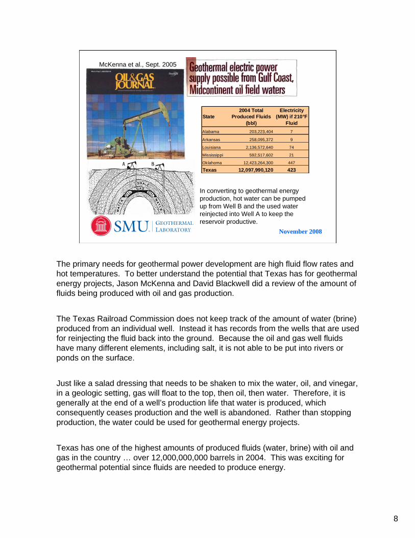
Texas Oil and Gas Well Temperature Data
~ 5000 wells plotted from East - Gulf -South Texas
6
3
5
2
4
To develop geothermal energy in Texas, the fluid temperatures need to be at least 200°F. Remember that the hotter the better so the wells with temperatures over 300°F are the first locations to look into for a geothermal power project. As you can see, below about 9000 feet in eastern - southern Texas the temperatures are usually above the 200°F starting point. Most of the wells are located between 10,000 and 13,000 feet that are above 200°F.
If we use 5000 wells as our total number, then from the red bar chart, we can read that about 16% of the wells have temperatures between 300 and 350°F. That means that about 800 wells are really hot.
Question for you: What temperature does water boil at if it is near sea level?

11
November 2008
120°F
140°F
160°F
180°F
200°F
220°F
240°F
260°F
280°F
300°F
320°F
Oil and Gas Well Temperatures at 12,000 ft
Produced by SMU Geothermal Laboratory
It is important to know that there are many wells that meet the temperature criteria for geothermal projects in Texas. Plotting the temperature data, we can make maps to help us understand where the temperatures vary. This map of the temperatures at 12,000 feet was created from oil and gas well temperatures. Although there are wells from all different depths, in making a map such as this, the data is limited to those values are between 10,000 to 14,000 feet for more accuracy.
12
November 2008
120°F
140°F
160°F
180°F
200°F
220°F
240°F
260°F
280°F
300°F
320°F
Oil and Gas Well Temperatures at 12,000 ft
Well Locations:Blue are shallow (<6000 feet)Black are deep (6000 to 15,000 feet)
Produced by SMU Geothermal Laboratory
Amarillo
Plainview
Wichita FallsParisGainesvilleLubbock
Texarkana
DallasFort WorthSnyderMarshallAbilene
AthensMidland
OdessaEl PasoBrownwood
NacogdochesWacoSan AngeloPecos Lufkin
Temple
HuntsvilleBryan
ConroeAustinBeaumontKerrvillePort ArthurHouston
San AntonioDel RioGalveston
Bay CityVictoria
Corpus ChristiLaredo
WeslacoBrownsville
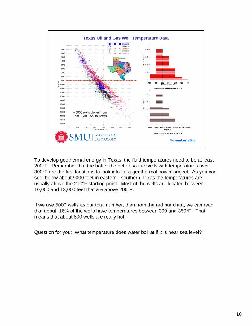
With the county boundaries, city names, and major roadways, hopefully you can determine what the temperature is where you live at 12,000 feet. If it is over 200°F then there is enough heat to generate electricity from geothermal resources right below your feet.

13
November 2008
Gradient, Thermal Conductivity, Heat Flow
Gradient = change in temperature over change in depth. Represents the slope of the temperature line.
Thermal Conductivity = the amount of heat able to transfer through a rock or layer. Varies because of:1. Mineral content (quartz is high, clay minerals are low)2. Fluid content (more water = higher value)3. Pressure (pressure connects surfaces for increase)4. Isotropy (how similar rock is in all directions)
Heat Flow = The amount of heat that moves through a layer of rock. Heat Flow = Gradient x Thermal Conductivity
mW/m2 = °C/km x W/m/K
m = milli W = Watts
m = meters km = kilometers
K = Kelvin °C = Celsius
Quartizite
Clay minerals
Science is filled with terminology related to the specific field of research. Here are three basic terms that are used daily in the SMU Geothermal Laboratory: gradient, thermal conductivity, and heat flow. Without realizing it, these are words that you use daily as well.
When you walk up a stairway or hill, the “gradient” is what determines how steep the stairs are or how difficult it is to climb the hill. In Math gradient is also referred to as the slope. For instance, the “slope of a line” is m in this equation. y = mx + b
On a hot day you quickly become aware of the thermal conductivity of the ground. Grass is not very conductive, so it stays cool, whereas the black pavement is very conductive and becomes very hot to touch. Another example related to thermal conductivity is when you use a microwave to heat something. Have you ever noticed that if you add water or another liquid to the leftovers, they heat faster? Water is able to absorb the microwave energy and then transfer it to the other food items. By connecting the pieces of food being heated, they get hot more quickly.
Luckily heat flow is slow in air so the hot oven feels warm when you put your hand into it, but does not burn you. Whereas metal has high heat flow and will transfer the heat from your stove through your pan and heat your food.

14
November 2008
Produced by SMU Geothermal Laboratory
DallasFort WorthMarshallne
Athens
BrownwoodNacogdochesWaco
LufkinTemple
HuntsvilleBryan
ConroeAustinBeaumontKerrvillePort ArthurHouston
San AntonioGalveston
Bay CityVictoria
Corpus Christiaredo
WeslacoBrownsville
-97 -96.8 -96.6 -96.4 -96.2 -9629
29.2
29.4
29.6
29.8
30
Colorado Co
Wharton Co
Lavaca Co
123
4 5
67
-97 -96.8 -96.6 -96.4 -96.2 -9629
29.2
29.4
29.6
29.8
30
123
4 5
67
-97 -96.8 -96.6 -96.4 -96.2 -9629
29.2
29.4
29.6
29.8
30
Wharton Co
Fayette Co
180 °F
200 °F
220 °F
240 °F
260 °F
280 °F
3000 ft temperatures
10,000 ft temperatures
12,000 ft temperatures
100 °F
110 °F
120 °F
123
4 5
67
-97 -96.9 -96.8 -96.7
29.2
29.3
Well Number for Stars
180°F200°F220°F240°F260°F280°F300°F320°F
12,000 ft Depth Temperatures
In doing research on geothermal resources, it is helpful to look at the gradient, the thermal conductivity and the heat flow of an area. The rock type, the fluid within the rock layers, and the pressure all are important parameters to determine the geothermal resources.
Although the 2004 Geothermal Map of North America helped determine that there were geothermal resources available, the details of where geothermal resources are accessible were not necessarily easy to depict except for generalizing that the eastern and southern portion of Texas have the most resource potential.
By looking more closely at a specific area, we can have a better resolution of the resources available. From data at different depths, the changes in the gradients between the wells help to show which wells to focus on.

15
November 2008
Well Longitude Latitude Depth (ft) BHT Temp (°F) Gradient (°F/ 1000 ft) Interval Gradient Temp @ 10,000 ft Temp @ 12000 ft1 -96.9806 29.1681 10656 245 16.4 234 267
-96.9806 29.1681 12925 308 18.4 27.8 254 291-96.9806 29.1681 14547 336 18.3 17.3 289
2 -96.9784 29.1645 7830 218 18.9 259-96.9784 29.1645 13315 320 18.8 18.6 295-96.9784 29.1645 14981 350 18.7 18.0 294
3 -96.9652 29.1453 10518 256 17.7 247 282-96.9652 29.1453 13236 317 18.7 22.4 294-96.9652 29.1453 14734 345 18.7 18.7 294
4 -96.8200 29.3350 9300 188 12.7 197 222-96.8200 29.3350 10005 198 12.8 14.2 198 224-96.8200 29.3350 11019 220 13.6 21.7 206 233
5 -96.7062 29.3454 10739 250 16.8 238 271-96.7062 29.3454 13246 291 16.7 16.4 270-96.7062 29.3454 13720 302 16.9 23.2 273
6 -96.9661 29.1768 3703 116 12.47 -96.9688 29.1827 3719 122 14.0
example -96.9806 29.1681 12925 308 =(E3-70)/D3*1000 =(E3-E2)/(D3-D2)*1000 =F3*((10000-D3)/1000)+E3
A B C D E F G H IUsing Data from Railroad Commission Well Log Headers
BHT = Bottom Hole TemperatureGradient = [(Total max temp. - surface temp. {70°F} ) ÷ by total depth] * 1000 ft.Interval Gradient = Difference between two segments of one wellTemp @ 10,000 ft = interpolated temperature using gradient
This spreadsheet gives you the equations to calculate gradient and temperatures at a specific depth that you can used to make detailed maps for your own area. There is data available on the Railroad Commission website and the SMU Geothermal Laboratory website: http://smu.edu/geothermal. If you need help finding it, give Maria Richards a call or email.

16
November 2008
50 70 90 110 130 150 170 190 210 230 250 270 290 310 330 350 370Temperature (°F)
15000
14000
13000
12000
11000
10000
9000
8000
7000
6000
5000
4000
3000
2000
1000
0
Dep
th (f
eet)
Texas Well Datafrom Lavaca County, Gulf Coast Area
calculated values
calculated values
Texas near surface ground temperature in Gulf Coast Note: These are uncorrected temperatures from the well log headers. Deep (1000 ft or more) wells measured just after drilling are usually too cold because of the impact of drilling fluid being related to surface temperature. Most wells increase in temperature approximately 40 - 60 °F at 10,000 feet.
This is an example of the plotted data for you to look at. looking at the whole graph, where would you draw a line to show the average gradient for the points above 10,000 feet? What about from 11,000 to the bottom? Are the gradients different for these two lines?

17
November 2008
Converting Thermal Heat to Electrical Energy
Step one:
Determine the well(s) fluid flow and fluid temperature.
Note - one gallon fills about 2/3 a cubic foot, thus a space 10’ x 10’ x 3’ is filled every minute for 500 gpm.
1000 kW = 1 MW= electricity for ~ 1000 people~ 225 homes
kW produced
If you can find the temperature of a well in your community, then you can predict how much energy maybe produced depending on the fluid flow for the well. Oil and gas wells typically produce less than 200 gallons per minute of fluid. The well would most likely have to be worked again to open up the rock layers with the most water. Therefore, the fluid flow is a parameter that you can adjust depending on your needs and resources. Try to calculate how much fluid you would need to generate enough electricity from a geothermal power plant for your school electrical consumption.

18
November 2008
BINARY CYCLE POWER PLANTV. Ryan © 2005
If the water that reaches the surface is not hot enough to produce steam directly, it can still produce electricity by feeding it into a Binary Power Plant. The hot water is fed into a heat exchanger. The heat from the water is absorbed by a liquid such as isopentane which boils at a lower temperature. The isopentane steam is used to drive turbines, producing electricity. The isopentane then condenses back to its liquid state and is used again.
Shown with moving parts at http://www.technologystudent.com/energy1/geo3.htm
Temperatures under 300°F use binary cycle technology.
Earth
There are different types of geothermal power plants. For places where the water is less than 300°F, a binary power plant is used. Most small geothermal power plants (less than 10 MW) are binary geothermal power plants.

19
November 2008
Converting Thermal Heat to Electrical Energy
Step two: Choose a power plant for fluid to run through to extract the heat.
These systems are designed to run on temperatures as low as 200 °F in Texas. The hotter the well fluids the more efficient. They need both a hot source of fluid and a cold source (or air cooled).
UTC PowerPureCycle (250 kW)
ElectraTherm INC.Green Machine
(80 kW)
ORMAT TechnologyOrganic Rankine Cycle ORC unit (250 kW)
What is exciting about this slide, is that there are more and more binary technologies being developed. In 2004, when the Geothermal Map of North America was being produced, no one was making small (less than 1 MW) power plants. ORMAT Technologies had made some in the past, but were not focusing on making them at the time.
The development of the UTC Power PureCycle is what seemed to get the geothermal community excited about small-scale projects and using them with oil and gas wells. The PureCycle is based on the Carrier air conditioning unit, only running it backwards. Rather than using electricity to take the heat out of the air, it uses the heat to generate electricity.

20
November 2008
How to Determine Your Area’s Geothermal Resources
Surface ground water temperatures
14
16
18
19.5
22
24
26
54 °F
58 °F
62°F
78 °F
66°F
70 °F
74 °F
Note: Students can calculate the ground temperature by using the outside home water tap. Measure the water temperature every 15 seconds until it levels off and reaches a constant temperature. The city water main pipes are at 5 - 15 feet below ground. The water in them equilibrates with the ground and represents the constant geothermal temperature for the ground in your area.
Deep water temperatures
1. Use area oil/gas wells from Railroad Commission for bottom hole temperatures.
2. Use local water wells from residential and public sources.
Map from SMU Geothermal Lab, Gass, 1982
Texas is estimated to have 910,000 EJ of Thermal Energy
… enough to power the state of Texas for the next 100 years.
Send Maria Richards a note about what temperatures you find. I can use this information when making other maps for Texas.

21
November 2008
http://www.rrc.state.tx.us/data/online/oilgasrecords.php
http://www.rrc.state.tx.us/data/online/gis/index.php
Click on Oil and Gas Well Records to get the Key Field Search for well logs. The Well Log headers give you temperature and depth.
Use the GIS Map Viewerto find individual wells close to your school.
Build Your Own Data Base for Classroom Projects

22
November 2008
Benefits of Geothermal Power
Provides clean, safe, renewable power
Uses little surface land area
Generates continuous, reliable “baseload” power
Extends the life of oil & gas extraction from a field
Note: There are over 18,000 active wells in the Texas Gulf CoastOver 11,000 wells are deeper than 10,000 feet

23
November 2008
Comparison of Alternative Electrical Energy Sources
Load FactorGeothermal Power Plant 90-95%Wind Turbine Fields 20-30%
25 MW Geothermal Plant = 100 MW Wind Plant
Geothermal = ~5 - 8 cents/kWhWind = ~5 cents/kWh
1 MW = Energy for 250 homes or 1000 people

24
November 2008
Jobs in Geothermal Energy
Geothermal Power - geologists, chemists, geophysicists, hydrologists, reservoir engineers, hydraulic engineers, power plant designers, and drillers
Environmental scientists - impact studies, permits, and leasing
Direct-Use - heating engineers for agricultural/aquaculture industries
Geothermal Heat Pumps - Mechanical engineers, drillers, and HVAC contractors for Home, School, and Office building systems – LEED Certification
Research Positions - engineers, geologists, chemists, and materials scientists for government, university, and company projects.

25
November 2008
• Visit a cave and compare the outside temperature with the inside temperature.
• Visit a school or building installing geothermal heat pumps to see how they work (Heat pump part diagram is shown.)
• Measure the groundwater temperature in your community
• Research if there were previously flowing wells or spas in your community
• What is the temperature of your city water when it comes out of the well? Do they have to cool it?
Geothermal Activity Suggestions