Final Environmental Impact Report 7th Street Bridge Project,
102
Final Environmental Impact Report 7 th Street Bridge Project, Modesto, California Prepared for Stanislaus County March 2017 2485 Natomas Park Drive Suite 600 Sacramento, CA 95833
Transcript of Final Environmental Impact Report 7th Street Bridge Project,

Final Environmental Impact Report 7th Street Bridge Project, Modesto, California
Prepared for
Stanislaus County
March 2017
2485 Natomas Park Drive Suite 600 Sacramento, CA 95833


EN1216161130SAC CH2M HILL, INC. III
Preface This document, together with the Draft Environmental Impact Report for the 7th Street Bridge Project in Modesto, California (Draft EIR), constitutes the Final Environmental Impact Report (Final EIR) for the project. The Draft EIR was circulated to affected public agencies and interested parties for a 45-day review period from August 23, 2016 to October 6, 2016. This Final EIR document consists of comments received by the Lead Agency (Stanislaus County) on the Draft EIR during the public review period, responses to those comments, and revisions that were made to the text of the Draft EIR.
Under the California Environmental Quality Act (CEQA), the Final EIR is an informational document prepared by the Lead Agency that must be considered by the decision makers before approving the proposed project. CEQA Guidelines Section 15132 specifies that a Final EIR shall consist of the following:
• The Draft EIR or a revision of the draft
• Comments and recommendations received on the Draft EIR, either verbatim or in summary
• A list of persons, organizations, and public agencies that provided comments on the Draft EIR
• The responses of the Lead Agency to the significant environmental points raised in the public review and consultation process
• Other information added by the Lead Agency
In conformance with the CEQA Guidelines, this Final EIR provides objective information regarding the potential environmental consequences of the proposed project. The Final EIR also examines mitigation measures to reduce or eliminate significant environmental impacts. The Final EIR will be used by Stanislaus County, the City of Modesto, and responsible agencies in making decisions regarding the project. The CEQA Guidelines require that, while the information in the Final EIR does not control Stanislaus County’s ultimate decision on the project, the County must respond to each significant effect identified in the Final EIR by issuing written findings for each significant effect before it approves a project.
Per Section 21081 of the California Public Resources Code, no public agency shall approve or carry out a project for which a certified EIR identifies one or more significant effects on the environment that would occur if the project is approved and carried out unless both of the following occur:
(A) The public agency makes one or more of the following findings with respect to each significant effect:
(1) Changes or alterations have been required in, or incorporated into, the project that mitigate or avoid the significant effects on the environment.
(2) Those changes or alterations are within the responsibility and jurisdiction of another public agency and have been, or can and should be, adopted by that other agency.
(3) Specific economic, legal, social, technological, or other considerations, including considerations for the provision of employment opportunities for highly trained workers, make infeasible the mitigation measures or alternatives identified in the EIR.
(B) With respect to significant effects that were subject to a finding under paragraph (3) of subdivision (A), the public agency finds that specific overriding economic, legal, social, technological, or other benefits of the project outweigh the significant effects on the environment.
This Final EIR will be made available to the public and commenting public agencies at least 10 days before the EIR certification hearing.
All documents referenced in this EIR are available for public review at the Stanislaus County Department of Public Works, 1716 Morgan Road, Modesto, on weekdays during normal business hours.

EN1216161130SAC CH2M HILL, INC. V
Contents Section Page
Preface ............................................................................................................................................... iii
1.0 Agencies, Organizations, and Individuals on Draft EIR Notification List ................................. 1-1
2.0 List of Comment Letters Received on the Draft EIR ............................................................... 2-1
3.0 Revisions to the Text of the Draft EIR .................................................................................... 3-1
4.0 Comments and Responses .................................................................................................... 4-1 Master Response 1: Selection of Preferred Alternative ............................................................... 4-1
Tables
1 List of Comment Letters ................................................................................................................ 2-1 3.6-1 Avoidance and Minimization Measures from the Natural Environment Study (NES) .................. 3-2
Figure
1 View of Lion’s Market Looking South ............................. Chapter 4, response to Comment Letter 6


SECTION 1
EN1216161130SAC CH2M HILL, INC. 1-1
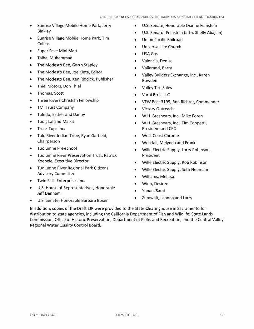
Agencies, Organizations, and Individuals on Draft EIR Notification List Copies of the Draft Environmental Impact Report for the 7th Street Bridge Project in Modesto, California (Draft EIR1) and/or the Notice of Availability for the Draft EIR were sent to the following agencies, organizations, and individuals:
• 10th Street Certified Farmers Market, Marion Bogdarich
• A.C. Trucking Company, Al Nunes • Altamont Corridor Express (San Joaquin
Regional Rail Commission), Brian Schmidt • Altamont Corridor Express (San Joaquin
Regional Rail Commission), Stacey Mortensen, Executive Director
• Aero Graphics, Casey Francis • Aguilar, Adriana and Carlos • Alberto, Irma and Alejandro • All Bonanza Dismantlers • Alliance-SBDC, David White, CEO • Allied Machine • Alvarado, Cesar • American Medical Response • Anaya, Carlos • Apostolic Jubilee Center • Arnold, Rick and Lori • Arrow Inn, Modesto • Aveytia, Toube and Juan • Bailey's Heating & Air Inc. • Baker, Robert • Ballew, Constance and Ronald • Barron, Trinidad and Samuel • Bays-Carnahan, Edna • BCK Real Estate Services LLC, Tom Krehbiel • Beard Land Improvement Company • Beard, Betty • Bearden Family Limited
1 CH2M HILL, Inc. 2016. Public Review Draft: Environmental Impact Report 7th Street Bridge Project, Modesto, California. Prepared for Stanislaus County. Online: http://www.7thstreetbridge.org/. August.
• Building Industry Association of the Greater Valley, John Beckman
• Bible Way Tabernacle • Big Bear Car Wash • Billings, Ronald • Boss, Larry • Bottling Group LLC • Brave Bull • Brinton, Michael • Broad Acres Mobile Home Park • Bruce, Emily • Buddington, Kathleen and Richard • Budget Inn, Modesto • Buehner, Larry • Burke, Steve • C & C Marine • Cable Family Ltd. Partnership • Caesar Family LP • California Auto Parts • California Central Valley Flood Protection,
Leslie Gallagher, President • California Flavor Nuts • California State Assembly, Honorable Kristin
Olsen • California State Lands Commission, Cy
Oggins, Chief • California State Senate, Honorable Anthony
Cannella • California State Senate, Honorable Cathleen
Galgiani
CHAPTER 1 AGENCIES, ORGANIZATIONS, AND INDIVIDUALS ON DRAFT EIR NOTIFICATION LIST
1-2 CH2M HILL, INC. EN1216161130SAC
• California State Senate, Honorable Tom Berryhill
• California State University Stanislaus, Ellen Junn
• California Trucking Association, Eric Sauer • California Trucking Association, Michael
Campbell, CEO • California Trucking Association, Shelly
Hardcastle • California Valley Miwok Tribe, Silvia Burley • Calkins, Scott • Capitol Door Sales • CBFA California Ltd. Partnership • Central Baptist Church • Central California Art Association at Mistlin
Gallery, Rick Allen • Central Valley Hispanic Chamber, Christine
Schweininger, President • Central Valley Property Inc. • Central Valley Recycling • Century 21, Ernie Nunes • Chase, Eleanor • Chavarin, Juan • Chevron Station at 1541 Crows Landing
Road • Christoulakis, Bobby and Mike • Church of Christ, Modesto • City Tow, Modesto • Collins Electrical Company, Brian Gini • CrossPoint Community Church • Crows Landing Flea Market • DeLano, Lee • Don's Mobile Glass • Driftwood Mobile Home Park • Dryden Golf Course • Duarte, Mary • E & J Gallo Winery, Drew Layland, Senior
Manager • Eagle Valley Investments Inc. • Egenberger, Bunthany and Joseph • El Concilio, Yamilet Valladolid, Site
Supervisor
• Escarcega, Juan • Farmland Working Group, Denny Jackman • Farriester, Lillie • Farriester's Auto, Mark Farriester • Fechter, Alejandrina • First Apostolic Christian Church • Fletcher, Timothy • Florez, Sandy • Folwell, Susan and Thomas • Freudenthal, Sharon and Fred • Friendly Village of Modesto • Friends of the Tuolumne, Dave and Allison
Boucher • Gama, Rosio • Garcia, Esther and Ernest • Garcia, Ramon • Garcia, Refujia • Garcia, Ricardo • Gas-n-Shop • Gomez, Jose and Yolanda • Gonsalves, Victoria and Jeffrey • Granite Construction, Jeremy Newswander • Great Valley Center, Dejeune M. Shelton • Great Valley Museum, Brandon Guzman • Guajardo, Patricia and Xavier • Guardiola, Robert • Gudino, Martin • Haldar, David • Heard, Sally • Henderson, Kitty • Historic Bridges, Nathan Holth • Hogue, Mikael • Hummer, Myriam and Michael • Iglesias Pentecostal Unida de Modesto,
Randy G. Keyes • Irby, Daniel • Jackman, Denny • Janopaul, Bridget M. • Johnson, Kimberly and Harold • Kassim, Fatima

CHAPTER 1 AGENCIES, ORGANIZATIONS, AND INDIVIDUALS ON DRAFT EIR NOTIFICATION LIST
EN1216161130SAC CH2M HILL, INC. 1-3
• King-Kennedy Memorial Center • Landmark Preservation Commission,
Dolores Niemi • Landmark Preservation Commission, Kent
Faulkner • Laracuente, Barbara and James • Lau Family Partners • Levario Jr., Ernesto • Levario, Julia • Liggett Bottling Co • Lion's Market, Abdul Hussain • Lo Bello, James • Locker, Vernita and Lloyd • Luna, Sandro and Susana • Maddux Youth Center • Maldonado, Luz • Mancini Hall Senior Center • Manson, Ora Jean • Martinez, Jose Luis • Martinez, Marivel and Federico • Mary Howell • McCoy Properties LP • McCoy, Alice • MCCV, Jennifer Carlson • McHenry Museum and Historical Society,
Don Scott • McHenry Museum and Historical Society,
Laura Mesa • Mendoza, Livier and Roberto • Mission Hill Truck School • Modesto Auto Wreckers • Modesto Car Toys • Modesto Certified Farmers Market • Modesto Chamber of Commerce, Cecil
Russell, CEO • Modesto City Airport • Modesto City Schools, Becky Fortuna • Modesto City Schools, Deborah Strom,
Supervisor of Transportation • Modesto City Schools, Pam Able,
Superintendent
• Modesto City Schools, Planning, Becky Meredith, Director
• Modesto Convention and Visitors Bureau, Jennifer Mullen, CEO
• Modesto Culture Commission, Ellen LaCoste • Modesto Downtown Improvement District,
Nancy Young, Executive Director • Modesto Fire Department, Sean Slamon,
Chief • Modesto Flea Market • Modesto Garden Club • Modesto Irrigation District • Modesto Junior College, Jill Stearns,
President • Modesto Livestock Auction and Market,
Luann Gremp • Modesto Mobile Village • Modesto Municipal Golf Course, John
Griston • Modesto Peace/Life Center • Modesto Regional Fire Authority, Gary
Hinshaw, Chief • Modesto Symphony Orchestra • Modesto Youth Theatre • Moreno, Anna Marie • Moreno, David • Moreno, Miguel • Muhummad, Talha • Murillo, John • Neder, Ron • New Bethany Missionary Baptist Church,
Quintin Kenoly • North Valley Yokuts Tribe, Katherine Perez • O'Brien, Sandra and Lawrence • Owens, Heather • Padilla, Lucia Nathllely • Palacios, Jose • Patton Music Company Inc. • Pepsi Cola Bottling Company • Perez, Jose • Praxair Inc. • Progressive Missionary Church

CHAPTER 1 AGENCIES, ORGANIZATIONS, AND INDIVIDUALS ON DRAFT EIR NOTIFICATION LIST
1-4 CH2M HILL, INC. EN1216161130SAC
• PS1 Landscape Architecture, Daniel Machado
• Quik Stop at 1500 Crows Landing Road • RaLanco Investment Corporation, Bruce
Ramsey • Ramirez, Juan • Ramos, Dorothy • Ramos, Nora • Rayco Industrial Supply • Rodriguez, Ezekiel • Rommel, Diana and Billie • Sabala, Mary and Josephine • Salcedo, Josephine • Saletta, Betty • Salvation Army • Santillan, Leticia and Antonio • Sawhney, Dinesh • Serrao Properties LLC • Seven-Up Bottling Co., Anthony J. Varni • Shackelford Elementary, Cecilia Franco,
Principal • Shaibi, Yehai • Shiva's Motel • Sierra Club, Brad Barker • Sierra Club-Yokuts Group • Sierra Vista Child and Family Services, Judy
Kindle, Executive Director • Sierra Vista Kirk Baucher School • Silva, Karen and Forrest • Simon, Jesus R. • Singh, Amarjit & Kishmir • Sirle, Rufina • Solar Cool Properties LLC • Southern Pacific Railroad • Southern Sierra Miwuk Nation, Anthony
Brochini, Chairperson • Southern Sierra Miwuk Nation, Jay Johnson,
Spiritual Leader • Southern Sierra Miwuk Nation, Les James,
Spiritual Leader • Southwest Tires
• StanCOG, Arthur Chen • StanCOG, Rosa De Leon Park, Executive
Director • StanCOG Board, Bill Zoslocki, Vice Chair • StanCOG Board, Dick Monteith • StanCOG Board, Ed Katen • StanCOG Board, Garth Soiseth • StanCOG Board, Jenny Kenoyer • StanCOG Board, Jill Silva • StanCOG Board, Jim DeMartini • StanCOG Board, Luis Molina • StanCOG Board, Manny Grewal • StanCOG Board, Michael Van Winkle • StanCOG Board, Mike Kline • StanCOG Board, Nick Candea • StanCOG Board, Richard O'Brien • StanCOG Board, Terry Withrow • StanCOG Board, Tom Dunlop • StanCOG Board, Vito Chiesa, Chairman • StanCOG Board, William O'Brien • Stanislaus Alliance, Jeff Rowe • Stanislaus Audubon Society • Stanislaus Connections, Jim Costello • Stanislaus Consolidated Fire Protection
District • Stanislaus County Arts Council • Stanislaus Distributing Co. • Stanislaus Food Products, Bill Hudelson • Stanislaus Food Products, Dino and Tom
Cortopassi • Stanislaus Local Agency Formation
Commission, Sara Lytle-Pinhey • StaRT Transit Center, Michael Keith,
Manager • Stateside Equipment Leasing • Stejskal, Lisa and Jeffrey • Stinnett, Alta and Dorwen • Stones of Bethel Church • Sunrise Village Mobile Home Park, Jeanne
Collins, Co-Manager
CHAPTER 1 AGENCIES, ORGANIZATIONS, AND INDIVIDUALS ON DRAFT EIR NOTIFICATION LIST
EN1216161130SAC CH2M HILL, INC. 1-5
• Sunrise Village Mobile Home Park, Jerry Binkley
• Sunrise Village Mobile Home Park, Tim Collins
• Super Save Mini Mart • Talha, Muhammad • The Modesto Bee, Garth Stapley • The Modesto Bee, Joe Kieta, Editor • The Modesto Bee, Ken Riddick, Publisher • Thiel Motors, Don Thiel • Thomas, Scott • Three Rivers Christian Fellowship • TMI Trust Company • Toledo, Esther and Danny • Toor, Lal and Malkit • Truck Tops Inc. • Tule River Indian Tribe, Ryan Garfield,
Chairperson • Tuolumne Pre-school • Tuolumne River Preservation Trust, Patrick
Koepele, Executive Director • Tuolumne River Regional Park Citizens
Advisory Committee • Twin Falls Enterprises Inc. • U.S. House of Representatives, Honorable
Jeff Denham • U.S. Senate, Honorable Barbara Boxer
• U.S. Senate, Honorable Dianne Feinstein • U.S. Senator Feinstein (attn. Shelly Abajian) • Union Pacific Railroad • Universal Life Church • USA Gas • Valencia, Denise • Vallerand, Barry • Valley Builders Exchange, Inc., Karen
Bowden • Valley Tire Sales • Varni Bros. LLC • VFW Post 3199, Ron Richter, Commander • Victory Outreach • W.H. Breshears, Inc., Mike Foren • W.H. Breshears, Inc., Tim Coppetti,
President and CEO • West Coast Chrome • Westfall, Melynda and Frank • Wille Electric Supply, Larry Robinson,
President • Wille Electric Supply, Rob Robinson • Wille Electric Supply, Seth Neumann • Williams, Melissa • Winn, Desiree • Yonan, Sami • Zumwalt, Leanna and Larry
In addition, copies of the Draft EIR were provided to the State Clearinghouse in Sacramento for distribution to state agencies, including the California Department of Fish and Wildlife, State Lands Commission, Office of Historic Preservation, Department of Parks and Recreation, and the Central Valley Regional Water Quality Control Board.


SECTION 2
EN1216161130SAC CH2M HILL, INC. 2-1
List of Comment Letters Received on the Draft EIR Section 4 of this document contains the comment letters that Stanislaus County received on the Draft EIR, as well as comments dictated orally to the stenographer at the public meeting held on August 29, 2016 (which are also referred to herein as “comment letters” for simplicity). Each comment letter has been assigned a number, as shown below in Table 1. Each individual comment within each letter also has been assigned a number, noted in the right margin of the letters as presented in Section 4. Table 1 lists the commenting party and date of each comment letter.
Table 1. List of Comment Letters 7th Street Bridge Project, Modesto, California
No. Agency/Organization/Individual Comment Letter Date
1-1 Larry Buehner (dictated to stenographer) August 29, 2016
1-2 Jeanne Collins (dictated to stenographer) August 29, 2016
2 Dean Phillips August 29, 2016
3 Betty Saletta August 29, 2016
4 Satjit Singh, DBA Star Auto Sales August 29, 2016
5 Elaine Ixcot August 29, 2016
6 Yehia Ahmed Qassem Shaibi August 31, 2016
7 Bill Hudelson September 1, 2016
8 Central Valley Regional Water Quality Control Board, Stephanie Tadlock, Environmental Scientist
September 15, 2016
9 California State Lands Commission, Cy R. Oggins, Chief, Division of Environmental Planning and Management
October 5, 2016
10 Nathan Holth October 6, 2016
11 Gracie Marx October 10, 2016

SECTION 3
EN1216161130SAC CH2M HILL, INC. 3-1
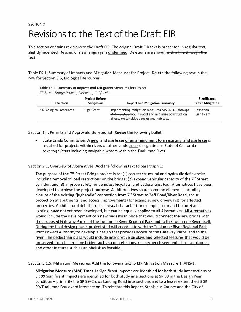
Revisions to the Text of the Draft EIR This section contains revisions to the Draft EIR. The original Draft EIR text is presented in regular text, slightly indented. Revised or new language is underlined. Deletions are shown with a line through the text.
Table ES-1, Summary of Impacts and Mitigation Measures for Project. Delete the following text in the row for Section 3.6, Biological Resources.
Table ES-1. Summary of Impacts and Mitigation Measures for Project 7th Street Bridge Project, Modesto, California
EIR Section Project Before
Mitigation Impact and Mitigation Summary Significance
after Mitigation
3.6 Biological Resources Significant Implementing mitigation measures MM-BIO-1 through MM—BIO-25 would avoid and minimize construction effects on sensitive species and habitats.
Less than Significant
Section 1.4, Permits and Approvals. Bulleted list. Revise the following bullet:
• State Lands Commission. A new land use lease or an amendment to an existing land use lease is required for projects within rivers or other lands areas designated as State of California sovereign lands including navigable waters within the Tuolumne River.
Section 2.2, Overview of Alternatives. Add the following text to paragraph 1:
The purpose of the 7th Street Bridge project is to: (1) correct structural and hydraulic deficiencies, including removal of load restrictions on the bridge; (2) expand vehicular capacity of the 7th Street corridor; and (3) improve safety for vehicles, bicyclists, and pedestrians. Four Alternatives have been developed to achieve the project purpose. All Alternatives share common elements, including closure of the existing “jughandle” connection from 7th Street to Zeff Road/River Road, scour protection at abutments, and access improvements (for example, new driveways) for affected properties. Architectural details, such as visual character (for example, color and texture) and lighting, have not yet been developed, but can be equally applied to all Alternatives. All Alternatives would include the development of a new pedestrian plaza that would connect the new bridge with the proposed Gateway Parcel of the Tuolumne River Regional Park and to the Tuolumne River itself. During the final design phase, project staff will coordinate with the Tuolumne River Regional Park Joint Powers Authority to develop a design that provides access to the Gateway Parcel and to the river. The pedestrian plaza would include interpretive displays and selected features that would be preserved from the existing bridge such as concrete lions, railing/bench segments, bronze plaques, and other features such as an obelisk as feasible.
Section 3.1.5, Mitigation Measures. Add the following text to EIR Mitigation Measure TRANS-1:
Mitigation Measure (MM) Trans-1: Significant impacts are identified for both study intersections at SR 99 Significant impacts are identified for both study intersections at SR 99 in the Design Year condition – primarily the SR 99/Crows Landing Road intersections and to a lesser extent the SB SR 99/Tuolumne Boulevard intersection. To mitigate this impact, Stanislaus County and the City of

CHAPTER 3 REVISIONS TO THE TEXT OF THE DRAFT EIR
3-2 CH2M HILL, INC. EN1216161130SAC
Modesto will program future improvements to these intersections into the 2018 Regional Transportation/Plan Sustainable Communities Strategy (RTP/SCS). have committed to improving these intersections in the future as part of a locally sponsored project that Intersection improvements could include signalization of the ramp intersections. Implementation of this MM would reduce traffic impacts to less-than-significant level.
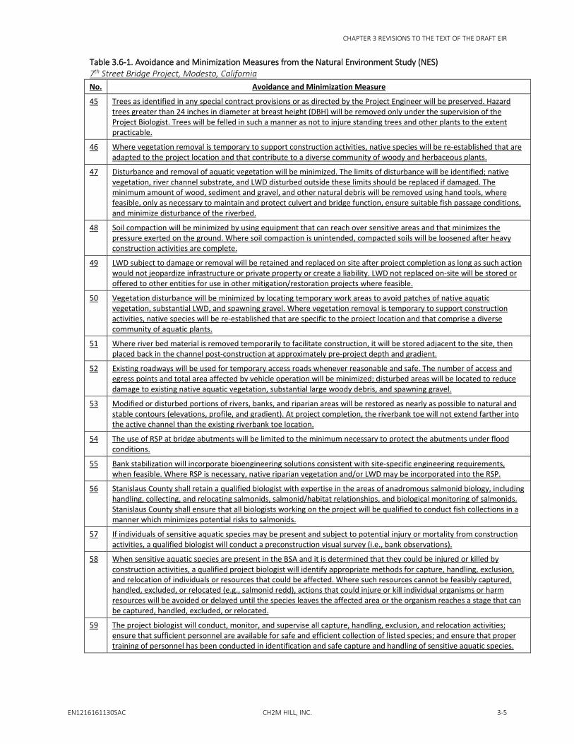
Section 3.6.5, Mitigation Measures. Add the following text to paragraph 2 and insert Table 3.6-1 below it:
According to the analysis presented in Section 3.6.2.5, project impacts would be less than significant with the incorporation of MMs. For Impacts BIO-1(a through e), BIO-2a, BIO-4, and BIO-7, mitigation is needed to reduce impacts to less than significant.
MM BIO-1: For the habitats and species of special concern that occur or have the potential to occur in the project area, implement the avoidance and minimization efforts listed in the Natural Environment Study (Appendix F). AMMs would avoid or reduce the potential biological effects of the project on each species or resource group to a less than significant level, as discussed in NES, Appendix F, Chapter 4.1 for riverine and riparian habitat, 4.2 for special-status plant species, 4.3 for special-status animal species, and 4.4 for other sensitive resources. AMMs include seasonal restrictions, preconstruction surveys, construction worker awareness training, best management practices, and similar actions which would limit the potential for impacts prior to and during construction. Where necessary, implement the additional compensatory mitigation for anadromous fish conservation listed in the Natural Environment Study or as required by the National Marine Fisheries Service or California Department of Fish and Wildlife (see NES, Appendix F, Chapters 4.3.2 to 4.3.6). The full list of the AMMs from the NES is presented in Table 3.6-1.
Table 3.6-1. Avoidance and Minimization Measures from the Natural Environment Study (NES) 7th Street Bridge Project, Modesto, California No. Avoidance and Minimization Measure
1 Consider bridge designs that minimize the permanent placement of structures or fill in the river corridor. Bridge design Alternatives 2A, 2B, and 3 will permanently occupy up to 0.01 acre of the Tuolumne River channel, while removing 0.13 acre of permanent fill (existing bridge piers) from the channel.
2 Channel access points will be flagged and used during site construction to minimize impacts to riverine and riparian habitats.
3 No refueling or handling of chemicals will be allowed in or within 100 feet of the active channel of the Tuolumne River. The contractor will establish proper staging and refueling areas to conduct these activities.
4 In-water work (e.g., existing pier demolition and new pier construction) will be limited to the time of the year specified in wildlife agency permits (assumed to be June 1 through October 31). In-water work that is necessary outside of the permitted seasonal window will be isolated from the flowing channel with cofferdams or similar structures. The contractor will prepare an isolation and dewatering plan for agency approval prior to working in wet areas outside of the seasonal window.
5 Before the onset of construction activities, a qualified person will conduct an education program for all construction personnel. The training will include a description of all sensitive species with the potential to occur in the Biological Study Area (BSA), and will review the mandatory conditions of approval agency permits and approvals.
6 Environmentally sensitive areas (ESAs) will be clearly flagged for the duration of site construction. Access to and use of ESAs will be restricted. Vehicle fueling and staging areas will be located at least 100 feet from flagged ESAs.
7 The contractor will prepare and implement a Stormwater Pollution Prevention Plan as required during permitting.
8 Discharging pollutants from vehicle and equipment cleaning into any storm drains or watercourses will be prohibited.
9 Concrete waste materials will not be allowed to enter the flowing water of the Tuolumne River. Waste materials will be disposed of offsite, at an approved location, where they cannot enter surface waters.
10 Spill containment kits will be maintained onsite at all times during construction activities and staging or fueling of equipment.

CHAPTER 3 REVISIONS TO THE TEXT OF THE DRAFT EIR
EN1216161130SAC CH2M HILL, INC. 3-3
Table 3.6-1. Avoidance and Minimization Measures from the Natural Environment Study (NES) 7th Street Bridge Project, Modesto, California No. Avoidance and Minimization Measure
11 Water will be applied in construction areas, including access roadways, to control dust. Soil stockpiles will be covered when weather conditions require.
12 Coir rolls, straw wattles, or similar materials will be used at the bases of slopes during construction to capture sediment.
13 Graded areas will be protected from excessive erosion using a combination of silt fences, fiber rolls along toes of slopes or along edges of designated staging areas, and erosion-control netting (such as jute or coir) as appropriate on sloped areas.
14 Borrow or fill material used in the BSA shall be native or, if from offsite, certified to be non-toxic and weed free.
15 Compensatory mitigation for the permanent loss of riverine habitat under Alternative 4 would likely be negotiated with the National Marine Fisheries Service (NMFS) and other permitting agencies.
16 Per USFWS (1996) guidelines,2 the botanical surveys conducted in association with this project can be used to evaluate habitat and potential for rare plant occurrence for 3 years, or until August 2015. If ground-disturbing activities are scheduled to begin after this date, pre-disturbance botanical surveys will be conducted to reassess site conditions and habitat suitability.
17 Equipment will be operated during the least sensitive diurnal, seasonal, and meteorological periods relative to the potential effects on listed salmon and steelhead, and their habitat, to the extent feasible.
18 Equipment will be inspected on a daily basis for leaks and completely cleaned of any external petroleum products, hydraulic fluid, coolants, and other deleterious materials prior to operating the equipment.
19 A Spill Prevention, Control, and Countermeasures (SPCC) Plan will be developed to provide consistent, appropriate responses to spills that may reasonably be expected with implementation of the project. The SPCC Plan will be kept on-site during construction and the appropriate materials and equipment will also be on-site during construction to ensure the SPCC Plan can be implemented. Personnel will be knowledgeable in the use and deployment of the materials and equipment so response to an accidental spill will be timely.
20 Maintenance and fueling of construction equipment and vehicles will not occur within 150 feet of the flowing water of the Tuolumne River.
21 Maintenance and construction activities will be avoided at night to the extent practicable. When night work cannot be avoided, disturbance of sensitive species and managed habitats (including Essential Fish Habitat) will be avoided and minimized by restricting substantial use of temporary lighting to the least sensitive seasonal and meteorological windows. Lights on work areas will be shielded and focused to minimize fugitive lighting.
22 Debris from demolition and construction activities will be disposed of off-site at an approved location where it cannot enter surface waters.
23 An underslung work platform, temporary work trestle, or similar structure will be installed to keep bridge debris and construction, maintenance, and repair materials from falling into the river during demolition and construction.
24 Temporary sediment basins, if installed, will be cleaned of sediment and the site restored to pre-construction contours (elevations, profile, and gradient) and function post-construction.
25 Construction staging and storage areas will be located a minimum of 150 feet from the flowing water of the Tuolumne River and from sensitive plant communities such as native riparian vegetation.
26 Excavated material will not be stored or stockpiled in the channel. Any excavated material that will not be placed back in the channel or on the bank after construction will be end-hauled to an approved disposal site.
27 Gravel and large woody debris (LWD) excavated from the channel that is temporarily stockpiled for reuse in the channel will be stored in a manner that prevents mixing with river flows.
28 "Wet–work” area(s) will be isolated from flowing water using cofferdams, gravel berms, or other methods approved by permitting agencies. Seasonal in-water work areas will be specified by regulatory agencies during project permitting, but are assumed to be June 1 through October 31.
2 United States Fish and Wildlife Service (USFWS). 1996. Guidelines for Conducting and Reporting Botanical Inventories for Federally Listed, Proposed, and Candidate Plants. Online: https://www.fws.gov/sacramento/ES/Survey-Protocols-Guidelines/Documents/Listed_plant_survey_guidelines.pdf. September 23.

CHAPTER 3 REVISIONS TO THE TEXT OF THE DRAFT EIR
3-4 CH2M HILL, INC. EN1216161130SAC
Table 3.6-1. Avoidance and Minimization Measures from the Natural Environment Study (NES) 7th Street Bridge Project, Modesto, California No. Avoidance and Minimization Measure
29 Cofferdams or other diversions will affect no more of the river channel than is necessary to support completion of the maintenance or construction activity. Immediately upon completion of in-channel work, temporary fills, cofferdams, diversions, and other in-channel structures that will not remain in the river (i.e., materials other than clean, spawning-sized gravel) will be removed in a manner that minimizes disturbance to the aquatic environment.
30 All structures and imported materials placed in the river channel or on the banks during construction that are not designed to withstand high flows will be removed before such flows occur.
31 Temporary fills, cofferdams, and diversions that are left in the river channel will be composed of washed, rounded, spawning-sized gravel between 0.4 to 4 inches in diameter; gravel in contact with flowing water will be left in place, modified (i.e., manually spread out using had tools if necessary) to ensure adequate passage for all life stages of fish present in the BSA, and then allowed to disperse naturally by high winter flows; materials placed above the Ordinary High Water Mark must be clean washed rock or contained to prevent material conveyance to the river or mixing with clean gravel.
32 The extent of dewatering will be limited to the minimum footprint (within coffered areas) necessary to support construction activities.
33 A wood block, bubble curtain, or similar protection will be installed (prior to the driving of piles) to further reduce the effects of noise and vibration to fish associated with pile-driving activities if it is determined that such activities must occur in the water.
34 The contractor will monitor turbidity levels in the river during construction and implement a plan that avoids unacceptable sedimentation and turbidity.
35 Water pumped from areas isolated from surface water to allow construction to occur in the dry will be discharged to an upland area providing overland flow and infiltration before returning to the river. Upland areas may include sediment basins of sufficient size to allow infiltration rather than overflow or adjacent dry gravel/sand bars if the water is clean and no visible plume of sediment is created downstream of the discharge. Other measures may be used to settle and filter water such as Baker tanks.
36 A NMFS-approved fish biologist will be onsite to observe de-watering activities and to capture/rescue any fish that are observed in an isolated area during dewatering activities.
37 Drilling will be conducted in dry river channel areas, to the extent practicable. If drilling must occur where water is present, the work area will be isolated from live water prior to work.
38 When geotechnical drilling takes place within the river channel, including gravel beds and bars, drilling mud will be bentonite without additives; initial drilling through gravel will be accomplished using clean water as a lubricant; after contact with bedrock or consolidated material, drilling mud (i.e., bentonite clay) may be used. All drilling fluids and materials will be self-contained and removed from the site after use; drilling will be conducted inside a casing so that all spoils are recoverable in a collection structure.
39 Stream width, depth, velocity, and slope that provide upstream and downstream passage of adult and juvenile fish will be preserved according to current NMFS and California Department of Fish and Wildlife (CDFW) guidelines and criteria or as developed in cooperation with NMFS and CDFW to accommodate site-specific conditions.
40 Flow through new and replacement structures must meet the velocity, depth, and other passage criteria for salmonid streams as described by the current NMFS and CDFW guidelines or as developed in cooperation with NMFS and CDFW to accommodate site-specific conditions.
41 Rock slope protection (RSP), sheet piles, and other erosion control materials will be pre-washed to remove sediment and/or contaminants.
42 Temporary material storage piles (e.g., RSP) will not be placed in the 100-year floodplain during the rainy season (October 15 through May 31), unless material can be relocated within 12 hours before the onset of a storm.
43 When concrete is poured to construct bridge footings or other infrastructure in the vicinity of flowing water, work must be conducted to prevent contact of wet concrete with water (e.g., within a cofferdam). Concrete or concrete slurry will not come into direct contact with flowing water.
44 Environmentally Sensitive Areas will be fenced to prevent encroachment of equipment and personnel into riparian areas, river channels and banks, and other sensitive habitats.
CHAPTER 3 REVISIONS TO THE TEXT OF THE DRAFT EIR
EN1216161130SAC CH2M HILL, INC. 3-5
Table 3.6-1. Avoidance and Minimization Measures from the Natural Environment Study (NES) 7th Street Bridge Project, Modesto, California No. Avoidance and Minimization Measure
45 Trees as identified in any special contract provisions or as directed by the Project Engineer will be preserved. Hazard trees greater than 24 inches in diameter at breast height (DBH) will be removed only under the supervision of the Project Biologist. Trees will be felled in such a manner as not to injure standing trees and other plants to the extent practicable.
46 Where vegetation removal is temporary to support construction activities, native species will be re-established that are adapted to the project location and that contribute to a diverse community of woody and herbaceous plants.
47 Disturbance and removal of aquatic vegetation will be minimized. The limits of disturbance will be identified; native vegetation, river channel substrate, and LWD disturbed outside these limits should be replaced if damaged. The minimum amount of wood, sediment and gravel, and other natural debris will be removed using hand tools, where feasible, only as necessary to maintain and protect culvert and bridge function, ensure suitable fish passage conditions, and minimize disturbance of the riverbed.
48 Soil compaction will be minimized by using equipment that can reach over sensitive areas and that minimizes the pressure exerted on the ground. Where soil compaction is unintended, compacted soils will be loosened after heavy construction activities are complete.
49 LWD subject to damage or removal will be retained and replaced on site after project completion as long as such action would not jeopardize infrastructure or private property or create a liability. LWD not replaced on-site will be stored or offered to other entities for use in other mitigation/restoration projects where feasible.
50 Vegetation disturbance will be minimized by locating temporary work areas to avoid patches of native aquatic vegetation, substantial LWD, and spawning gravel. Where vegetation removal is temporary to support construction activities, native species will be re-established that are specific to the project location and that comprise a diverse community of aquatic plants.
51 Where river bed material is removed temporarily to facilitate construction, it will be stored adjacent to the site, then placed back in the channel post-construction at approximately pre-project depth and gradient.
52 Existing roadways will be used for temporary access roads whenever reasonable and safe. The number of access and egress points and total area affected by vehicle operation will be minimized; disturbed areas will be located to reduce damage to existing native aquatic vegetation, substantial large woody debris, and spawning gravel.
53 Modified or disturbed portions of rivers, banks, and riparian areas will be restored as nearly as possible to natural and stable contours (elevations, profile, and gradient). At project completion, the riverbank toe will not extend farther into the active channel than the existing riverbank toe location.
54 The use of RSP at bridge abutments will be limited to the minimum necessary to protect the abutments under flood conditions.
55 Bank stabilization will incorporate bioengineering solutions consistent with site-specific engineering requirements, when feasible. Where RSP is necessary, native riparian vegetation and/or LWD may be incorporated into the RSP.
56 Stanislaus County shall retain a qualified biologist with expertise in the areas of anadromous salmonid biology, including handling, collecting, and relocating salmonids, salmonid/habitat relationships, and biological monitoring of salmonids. Stanislaus County shall ensure that all biologists working on the project will be qualified to conduct fish collections in a manner which minimizes potential risks to salmonids.
57 If individuals of sensitive aquatic species may be present and subject to potential injury or mortality from construction activities, a qualified biologist will conduct a preconstruction visual survey (i.e., bank observations).
58 When sensitive aquatic species are present in the BSA and it is determined that they could be injured or killed by construction activities, a qualified project biologist will identify appropriate methods for capture, handling, exclusion, and relocation of individuals or resources that could be affected. Where such resources cannot be feasibly captured, handled, excluded, or relocated (e.g., salmonid redd), actions that could injure or kill individual organisms or harm resources will be avoided or delayed until the species leaves the affected area or the organism reaches a stage that can be captured, handled, excluded, or relocated.
59 The project biologist will conduct, monitor, and supervise all capture, handling, exclusion, and relocation activities; ensure that sufficient personnel are available for safe and efficient collection of listed species; and ensure that proper training of personnel has been conducted in identification and safe capture and handling of sensitive aquatic species.
CHAPTER 3 REVISIONS TO THE TEXT OF THE DRAFT EIR
3-6 CH2M HILL, INC. EN1216161130SAC
Table 3.6-1. Avoidance and Minimization Measures from the Natural Environment Study (NES) 7th Street Bridge Project, Modesto, California No. Avoidance and Minimization Measure
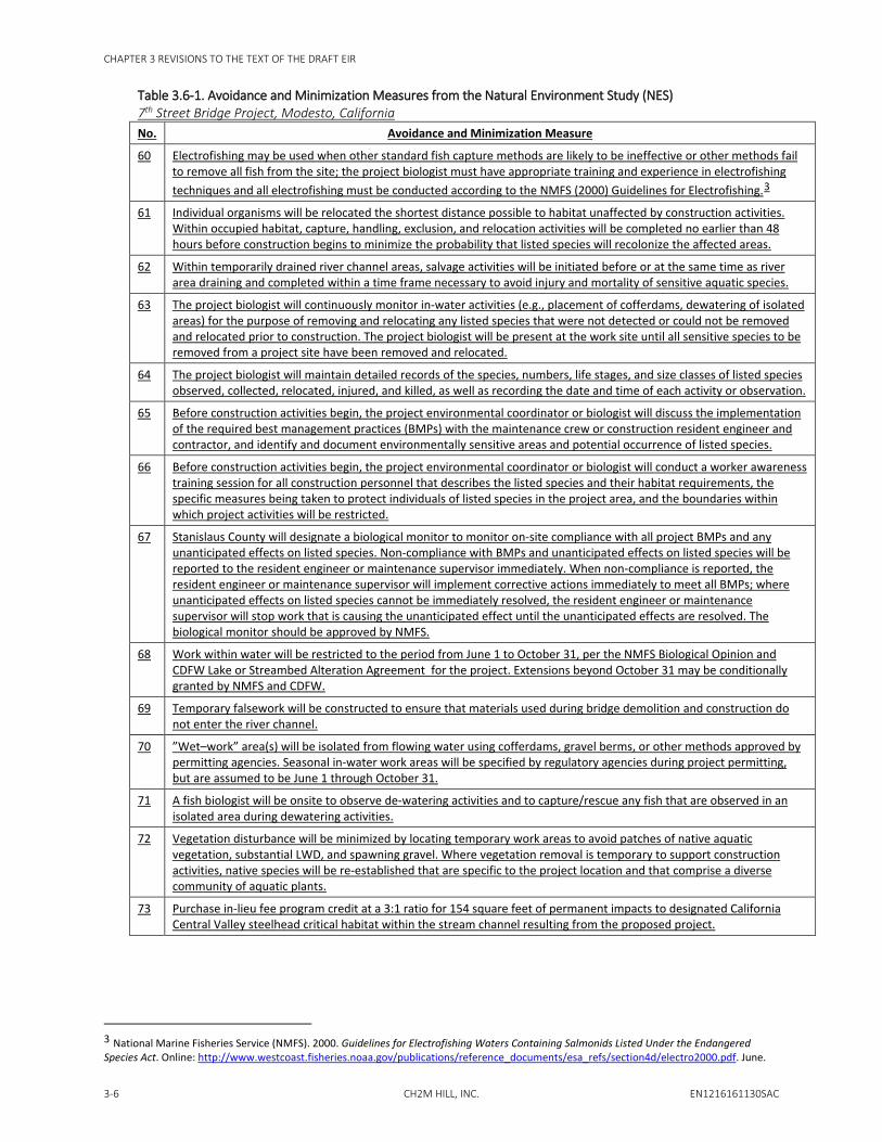
60 Electrofishing may be used when other standard fish capture methods are likely to be ineffective or other methods fail to remove all fish from the site; the project biologist must have appropriate training and experience in electrofishing techniques and all electrofishing must be conducted according to the NMFS (2000) Guidelines for Electrofishing.3
61 Individual organisms will be relocated the shortest distance possible to habitat unaffected by construction activities. Within occupied habitat, capture, handling, exclusion, and relocation activities will be completed no earlier than 48 hours before construction begins to minimize the probability that listed species will recolonize the affected areas.
62 Within temporarily drained river channel areas, salvage activities will be initiated before or at the same time as river area draining and completed within a time frame necessary to avoid injury and mortality of sensitive aquatic species.
63 The project biologist will continuously monitor in-water activities (e.g., placement of cofferdams, dewatering of isolated areas) for the purpose of removing and relocating any listed species that were not detected or could not be removed and relocated prior to construction. The project biologist will be present at the work site until all sensitive species to be removed from a project site have been removed and relocated.
64 The project biologist will maintain detailed records of the species, numbers, life stages, and size classes of listed species observed, collected, relocated, injured, and killed, as well as recording the date and time of each activity or observation.
65 Before construction activities begin, the project environmental coordinator or biologist will discuss the implementation of the required best management practices (BMPs) with the maintenance crew or construction resident engineer and contractor, and identify and document environmentally sensitive areas and potential occurrence of listed species.
66 Before construction activities begin, the project environmental coordinator or biologist will conduct a worker awareness training session for all construction personnel that describes the listed species and their habitat requirements, the specific measures being taken to protect individuals of listed species in the project area, and the boundaries within which project activities will be restricted.
67 Stanislaus County will designate a biological monitor to monitor on-site compliance with all project BMPs and any unanticipated effects on listed species. Non-compliance with BMPs and unanticipated effects on listed species will be reported to the resident engineer or maintenance supervisor immediately. When non-compliance is reported, the resident engineer or maintenance supervisor will implement corrective actions immediately to meet all BMPs; where unanticipated effects on listed species cannot be immediately resolved, the resident engineer or maintenance supervisor will stop work that is causing the unanticipated effect until the unanticipated effects are resolved. The biological monitor should be approved by NMFS.
68 Work within water will be restricted to the period from June 1 to October 31, per the NMFS Biological Opinion and CDFW Lake or Streambed Alteration Agreement for the project. Extensions beyond October 31 may be conditionally granted by NMFS and CDFW.
69 Temporary falsework will be constructed to ensure that materials used during bridge demolition and construction do not enter the river channel.
70 ”Wet–work” area(s) will be isolated from flowing water using cofferdams, gravel berms, or other methods approved by permitting agencies. Seasonal in-water work areas will be specified by regulatory agencies during project permitting, but are assumed to be June 1 through October 31.
71 A fish biologist will be onsite to observe de-watering activities and to capture/rescue any fish that are observed in an isolated area during dewatering activities.
72 Vegetation disturbance will be minimized by locating temporary work areas to avoid patches of native aquatic vegetation, substantial LWD, and spawning gravel. Where vegetation removal is temporary to support construction activities, native species will be re-established that are specific to the project location and that comprise a diverse community of aquatic plants.
73 Purchase in-lieu fee program credit at a 3:1 ratio for 154 square feet of permanent impacts to designated California Central Valley steelhead critical habitat within the stream channel resulting from the proposed project.
3 National Marine Fisheries Service (NMFS). 2000. Guidelines for Electrofishing Waters Containing Salmonids Listed Under the Endangered Species Act. Online: http://www.westcoast.fisheries.noaa.gov/publications/reference_documents/esa_refs/section4d/electro2000.pdf. June.

CHAPTER 3 REVISIONS TO THE TEXT OF THE DRAFT EIR
EN1216161130SAC CH2M HILL, INC. 3-7
Table 3.6-1. Avoidance and Minimization Measures from the Natural Environment Study (NES) 7th Street Bridge Project, Modesto, California No. Avoidance and Minimization Measure
74 The following measures for western pond turtle will be implemented: • Preconstruction surveys for presence/absence • Dewatering of work areas and cofferdams to prevent rewatering • Stanislaus County will ensure that a qualified biologist is on site during major ground-disturbing activities and
dewatering to capture and relocate turtles as necessary
75 The following measures for burrowing owl will be implemented: • Prior to ground-disturbing activities in the BSA, Stanislaus County will conduct surveys for burrowing owls using the
guidance provided by the California Burrowing Owl Consortium (1993).4 • Active burrows will be avoided by establishing a no-work buffer of 50 meters during the non-nesting period of
September 1 to January 31, unless modified by the CDFW. • Active burrows will be avoided by establishing a no-work buffer of 75 meters during the nesting period (February 1
to August 31), unless modified by the CDFW. • Unless agreed to otherwise by Stanislaus County and CDFW, compensatory mitigation for impacts to burrowing owl
and its suitable foraging habitat will follow CDFW guidance (CDFG, 20125).
76 The following measures for Swainson’s hawk will be implemented: • Stanislaus County will complete surveys for nesting Swainson’s hawk within the BSA and within an appropriate buffer
around the BSA following guidelines of the Swainson’s hawk Technical Advisory Committee (SHTAC, 20006). • If active nest trees are found and may be affected, CDFW will be notified immediately and consultation may be
required. • The project may be designed or reconfigured to avoid and/or minimize impacts to nesting Swainson’s hawks.
• CDFG (19947) provides recommendations for seasonal work restrictions and buffers from active nests while conducting project activities. Stanislaus County will work with CDFW to identify and establish appropriate buffers around active nests during the period March 1 to September 15.
77 The following measures for red bats will be implemented: • During the summer or early fall immediately preceding bridge demolition, complete surveys to confirm what bat
species are using the existing bridge structure and in what capacity. • Develop a site-specific bat mitigation plan to:
– Humanely exclude bats from roosting in trees that are planned for removal or trimming
– Humanely exclude bats from roosting on the existing bridge structure • Bats will not be excluded from using the existing bridge during the maternal roosting period of April 15 to August 31
unless otherwise agreed to by Stanislaus County and CDFW.
78 To avoid direct impacts to nesting cliff swallow, Stanislaus County, in consultation with CDFW, will develop and implement a nesting bird exclusion plan prior to site construction. This plan will: • Include provisions to remove relict nests from the existing bridge understructure outside of the typical nesting
season. • Exclude birds from establishing new nests on the bridge structure (existing or new bridge) by hanging exclusion
netting or some similar technique approved by CDFW.
79 A preconstruction nesting bird survey will be conducted to identify active nests within the BSA. Stanislaus County may remove unoccupied nests during the non-nesting period (September 1 to February 15).
4 California Burrowing Owl Consortium. 1993. Burrowing Owl Survey Protocol and Mitigation Guidelines. April. 5 California Department of Fish and Game (CDFG). 2012. Staff report on burrowing owl mitigation. State of California, Natural Resources Agency, Department of Fish and Game. March 7. 6 Swainson’s Hawk Technical Advisory Committee (SHTAC). 2000. Recommended Timing and Methodology for Swainson’s Hawk Nesting Surveys in California’s Central Valley. May 31, 2000. 7 California Department of Fish and Game (CDFG). 1994. Staff Report Regarding Mitigation for Impacts to Swainson’s Hawks (Buteo swansoni) in the Central Valley of California. November 8, 1994.

CHAPTER 3 REVISIONS TO THE TEXT OF THE DRAFT EIR
3-8 CH2M HILL, INC. EN1216161130SAC
Table 3.6-1. Avoidance and Minimization Measures from the Natural Environment Study (NES) 7th Street Bridge Project, Modesto, California No. Avoidance and Minimization Measure
80 If occupied nests (i.e., nests with birds or eggs) are present within the BSA, work within 50 feet of the nest of passerine species or 300 feet of raptor species will be avoided. Work shall not be permitted within this buffer until a qualified biologist has determined that nests are no longer active (i.e., young have fledged, or nest has failed)
81 Trees will be removed during the non-nesting season Sept. 1 to Feb 15. If vegetation removal is required during the nesting season, an approved biologist will survey for active nesting 72 hours prior to vegetation removal.
82 A bird exclusion plan will be developed in the event that nesting is identified on the bridge structure.
Section 3.7.5, Mitigation Measures. Add the following text to EIR Mitigation Measure CUL-3b (second bullet):
• Stanislaus County shall investigate the feasibility of removing historic elements from the 7th Street Bridge prior to its demolition. If feasible, Stanislaus County shall remove the selected features and install them within the pedestrian plaza. These features may include one or more of the concrete lions, railing/bench segments, an obelisk, and one or more of the bridge’s bronze plaques. The concrete lion(s) installed in the pedestrian plaza may be replicated from an original if it is determined that the historic lions are too deteriorated. The plaza also will include a salvaged cutaway portion of the existing bridge that shows the underlying steel structure supporting the “canticrete” bridge design. This salvaged cutaway will be selected to show how the original bridge design featured an internal steel structure encased in concrete. Interpretation of the cutaway should include images of the original bridge design drawings, if those images are available, and otherwise will follow the requirements for interpretive exhibits described above. Stanislaus County shall ensure that the selected features are adequately stored and protected during the interim between their removal and installation in the pedestrian plaza. The selected features shall be installed in the pedestrian plaza within 12 months of the completion of the new 7th Street Bridge.
Section 5.2.7, Utilities and Service Systems. Add the following text to paragraph 1:
Project construction would result in a temporary increase in construction jobs, but it is anticipated these jobs would be filled by construction-related companies in Modesto and Stanislaus County (see [Draft EIR] Section 5.2.4) and would not result in changed demands for utilities and service systems. The project would be designed to protect and avoid the wastewater pipeline that passes along the north bank of the Tuolumne River, parallel to and just south of B Street. The project would require some minor utility work to reconfigure local water and sewer lines and the City would install a new 16 inch water line on the new bridge. This minor work would have negligible impacts.
SECTION 4
EN1216161130SAC CH2M HILL, INC. 4-1
Comments and Responses During the review of the public comments received on the Draft EIR, Stanislaus County identified one recurring theme that was expressed by many commenters: statements of opinion regarding their preference for selection of a preferred alternative. Instead of repeating responses to this theme throughout the individual responses to comments that follow in this section, Stanislaus County and the City of Modesto are responding to them in the Master Response shown below. When individual comments can be addressed (or partially addressed) by this Master Response, the individual response directs the reader to the following text.
Master Response 1: Selection of Preferred Alternative Four bridge replacement or retrofit alternatives have been the focus of discussion during all project reviews to date, and all four were included in the Draft EIR for review of their relative environmental impacts. Based on several factors including the public and agency comments received on the Draft EIR, Stanislaus County is recommending the selection of Alternative 2B, Existing Bridge Alignment (Standard Bridge), to be carried forward as the preferred alternative. If Alternative 2B is adopted by the Stanislaus County Board of Supervisors as part of the Final EIR certification process, it would be advanced to the final stages of project development leading to construction.
The primary determining factor in selecting Alternative 2B is cost. Alternative 2B is the lowest cost alternative, and is supported by Caltrans for that reason. As described throughout the public review, Caltrans is a critical funding partner, and their participation is needed in order to construct the new bridge. Caltrans has indicated that they would not contribute funding toward the Alternative 2A arch bridge structure. Given competing local priorities, Stanislaus County and the City of Modesto cannot support fully funding the Alternative 2A arch bridge.
In addition, Alternative 2B requires the least amount of property acquisition and displacement, and therefore is expected to cause the least disruption to nearby property owners, businesses, and residents. As described during public meetings, the tradeoff for Alternative 2B’s reduced footprint has been the willingness of the local community to accept closing the bridge during construction. Based on feedback received during public review, it appears that temporary bridge closure (mitigated by a temporary pedestrian and bicycle crossing and by increased transit service) is acceptable to the community.
Although Alternative 4, Retrofit and New Two-Lane Bridge, would preserve the existing 7th Street Bridge, it is not being selected as the preferred alternative. Primarily, this is because of cost; Alternative 4 is more expensive than Alternative 2B and also has much greater potential for higher-than-expected costs due to the unknown condition of the underlying steel structure. In addition, as described in the Draft EIR (see Impact CUL-3), Alternative 4 would have significant cultural resources impacts due to the physical changes to the bridge and the indirect changes in the bridge’s historical context. Impacts to the historic bridge would be significant under all alternatives.


EN1216161130SAC CH2M HILL, INC.
1. Comments Dictated to Stenographer at Public Meeting
(August 29, 2016) (1-1, Larry Buehner, and
1-2, Jeanne Collins)

Comments Dictated to the Stenographer at the Public Meeting on the Draft EIR Two comments from members of the public were dictated to the stenographer present at the August 29, 2016 public meeting on the 7th Street Bridge Project Draft Environmental Impact Report, as presented below. The meeting was held from 6:00 p.m. – 8:00 p.m. in the Basement Training Room of the Stanislaus County Administrative Offices at 1010 Tenth Street, Modesto, California.
These comments are reprinted from the Public Meeting to Review Draft Environmental Impact Report Summary Report for the project. The complete public meeting summary report, including the transcript of a question‐and‐answer session with project staff, is available online at www.7thStreetBridge.org. The written comments submitted by the public at this meeting are each presented as separate letters in Chapter 4 of the Final Environmental Impact Report, along with the responses from the County.
1-1. Larry Buehner
I'm not exactly in the bridge area, but I'm a little further south on Crows Landing Road. And we have a big traffic problem trying to get out on Crows Landing as it is. And I realize what they're saying, different pot of money, different phase. But I'd like to see this EIR, if it hasn't already addressed the additional traffic flow, to address that for another phase. We need some red lights down there by the freeway area to where Crows Landing ‐‐ all that traffic will be coming out of south Modesto to where they could get on the freeway and a red light to slow it down so some of the side streets can get out onto Crows Landing Road. Because it's hard right now, let alone with additional traffic to get out.
And then also, hopefully we can address how the big rigs can get across the railroad track at the north end of the bridge. Because that's good industrial area and Modesto is out of industrial area. And we can make that industrial area bigger if the big rigs can get in and out of there. Right now, it's just traffic grid locked especially during the season right now with all of the produce that's running.
1-2. Jeanne Collins
On project 2‐B ‐‐ 2‐A and 2‐B, we need to see if we can get a left turn to go downtown instead of ‐‐ because a lot of people go downtown instead of going the other direction. And see if we can figure out a signal to where we can put a signal in our park, in Sunrise Village. We need a way to where we can turn left.
bbell
Text Box
1
YS017430
Line
YS017430
Line
YS017430
Text Box
1
YS017430
Text Box
2


CHAPTER 4 COMMENTS AND RESPONSES
EN1216161130SAC CH2M HILL, INC.
Comment Letter 1: Comments Dictated to Stenographer at Public Meeting
Comment 1-1: Larry Buehner, August 29, 2016 Response to Comment 1-1
Thank you for your question. Current and future traffic flow in the bridge area and along Crow’s Landing Road were analyzed in the traffic study and in the Draft EIR (see Draft EIR Section 3.1). These studies identified increased future traffic at the SR 99/Crows Landing Road intersection and, to a lesser extent, at the southbound SR 99/Tuolumne Boulevard intersection. To address the increased traffic, Stanislaus County and the City of Modesto have committed to improve these intersections as part of a separate locally sponsored project that could include addition of traffic signals. In addition, there is a separate project to widen Crows Landing Road between SR 99 and 7th Street from two lanes to four lanes that is listed in the 2014 Stanislaus Council of Governments Regional Transportation Plan/Sustainable Communities Strategy (RTP/SCS).8
Comment 1-2: Jeanne Collins, August 29, 2016 Response to Comment 1-2
Thank you for your question. Design engineers are evaluating the best option for reconfiguring the 7th Street/Crow’s Landing Road intersection for optimal safety and traffic flow. The intersection reconfiguration will also affect ingress and egress from Sunrise Village. Safe and efficient access to Sunrise Village is being taken into consideration and the current challenges of entering Sunrise Village from the south and exiting Sunrise Village to the north are recognized.
In response to this comment, the County considered an optional configuration using a roundabout to account for all traffic movements – along 7th Street and Crows Landing Road, and into and out of Sunrise Village. The option has some potential to benefit Sunrise Village residents, but with tradeoffs such as increased right-of-way acquisition. The County will consider this and other reasonable options during final design.
8 Stanislaus Council of Governments (StanCOG). 2014. 2014 Regional Transportation Plan Sustainable Communities Strategy, Stanislaus County. Online: http://www.stancog.org/pdf/rtp/final-2014-rtpscs.pdf. June.


EN1216161130SAC CH2M HILL, INC.
2. Letter from Dean Phillips, August 29, 2016


From: Judith BuetheTo: [email protected]; Franck, Matthew/SAC; Elwood, Jennifer/SACCc: MelissaSubject: 7th St Bridge [EXTERNAL]Date: Monday, August 29, 2016 10:46:30 AM
Team,
See attached.
Judith
-----Original Message-----From: Dean Phillips [mailto:[email protected]]Sent: Monday, August 29, 2016 5:44 AMTo: Judith Buethe <[email protected]>Subject: 7th St Bridge
Judith:Everything has a useful life, and the 7th St Bridge has passed that point. Keeping it in any form will just be amaintenance headache. Save the lions, and build a new bridge.Dean Phillips.
Sent from my iPhone
bbell
Text Box
2
YS017430
Line
YS017430
Text Box
1

CHAPTER 4 COMMENTS AND RESPONSES
EN1216161130SAC CH2M HILL, INC.
Comment Letter 2: Letter from Dean Phillips, August 29, 2016 Response to Comment 2-1
This comment expresses support for Project Alternative 2B, the alternative selected by the County as the Preferred Alternative (see Master Response 1). This comment also expresses support for saving the existing 7th Street Bridge lions. As discussed in Draft EIR Section 3.7.5 (Mitigation Measure [MM] CUL-3), Stanislaus County intends to preserve one or more of the concrete lions and install them in the new pedestrian plaza that will be created as part of this project. However, if the original lions are determined to be too deteriorated, replicas will be created and installed. Text has also been added to Draft EIR Section 2.2, Overview of Alternatives, to reflect this (see page 3-1 above).

EN1216161130SAC CH2M HILL, INC.
3. Letter from Betty Saletta, August 29, 2016


bbell
Text Box
3

YS017430
Line
bbell
Text Box
3
bbell
Text Box
1

CHAPTER 4 COMMENTS AND RESPONSES
EN1216161130SAC CH2M HILL, INC.
Comment Letter 3: Letter from Betty Saletta, August 29, 2016 Response to Comment 3-1
As discussed in MM CUL-3 in Section 3.7.5 of the Draft EIR, Stanislaus County will install one or more of the concrete lions in the new pedestrian plaza that will be created as part of this project. However, if the original lions are determined to be too deteriorated, replicas will be created and installed. The commenter suggests that bronze replicas are likely the best option given the condition of the existing lions. MM CUL-3b, using language reviewed and accepted by the State Historic Preservation Officer (SHPO), is flexible on exactly how the lions will be preserved. As part of the final design process, project engineers and historical design specialists will determine if the existing lions can be moved without further damage, and assess the relative merits of restoration versus recreating the lions using concrete or another material such as bronze.


EN1216161130SAC CH2M HILL, INC.
4. Letter from Satjit Singh, DBA Star Auto Sales, August 29, 2016


bbell
Text Box
4
YS017430
Line
bbell
Text Box
1


CHAPTER 4 COMMENTS AND RESPONSES
EN1216161130SAC CH2M HILL, INC.
Comment Letter 4: Letter from Satjit Singh, DBA Star Auto Sales, August 29, 2016 Response to Comment 4-1
Thank you for your question. Affected parties will be contacted regarding the relocation assistance and benefits when the right-of-way phase of the project begins. The federal Uniform Relocation Assistance and Real Properties Acquisition Policies Act (Uniform Act) and the California Relocation Assistance Act provide advisory services and monetary benefits to permanently and temporarily displaced parties. A general overview of the relocation assistance and benefits is provided in Draft EIR Section 2.3 and Appendix A (Draft Relocation Impact Report).


EN1216161130SAC CH2M HILL, INC.
5. Letter from Elaine Ixcot, August 29, 2016


From: Judith BuetheTo: Elaine IxcotSubject: RE: Lion"s Bridge [EXTERNAL]Date: Monday, August 29, 2016 1:13:24 PM
Dear Ms. Ixcot: Thank you for your email, which I am forwarding to the engineers and environmental specialistsworking on the project. We appreciate your taking the time to provide your comments. Judith BuethePublic Outreach Coordinator
From: Elaine Ixcot [mailto:[email protected]] Sent: Monday, August 29, 2016 12:47 PMTo: Judith Buethe <[email protected]>Subject: Fw: Lion's Bridge
On Monday, August 29, 2016 12:40 PM, Elaine Ixcot <[email protected]> wrote:
Good afternoon,I read about the meeting on the Lion's Bridge this am in the MoBee. I am soooo sorryI will not be able to attend because of a prior engagement!I am very intersted in our beautiful bridge and the Lion's who have resided at eachend for the past century.My request is.... if another bridge is constructed on a near by site.... Could we pleasehave our now standing Lion's Bridge as a walking bridge? Please, Please, Please.If this is not possible and they reconstrut the bringe on the same spot, please restorethe Lion's at the ends of the new bridge....My first request is my utmost request as we would still have our beautiful/originalbridge.I am a long time resident of Modesto (almost 79 years) and have given this matter alot of thought.Please don't destroy our history.Sincerly,Elaine D. Ixcot805 Tully Rd. # 5Modesto, Ca. 95350209 576-8391.
YS017430
Text Box
1
YS017430
Text Box
2
YS017430
Line
YS017430
Line
bbell
Text Box
5


CHAPTER 4 COMMENTS AND RESPONSES
EN1216161130SAC CH2M HILL, INC.
Comment Letter 5: Letter from Elaine Ixcot, August 29, 2016 Response to Comment 5-1
Thank you for your question. A project alternative that would maintain the existing 7th Street Bridge for bicycle and pedestrian use was initially considered based on public feedback during the scoping process (see Draft EIR Section 2.5.2, New Downstream Bridge with Bridge Retrofit for Bicycle/Pedestrian Use). This alternative would require construction of a new downstream bridge for vehicle traffic only and would also require retrofitting the existing bridge similar to Alternative 4, Retrofit and New Two-Lane Bridge, for structural safety.
As discussed in Draft EIR Section 2.5.2, this alternative was eliminated from consideration for several reasons. In terms of financial considerations, the 7th Street Bridge project is supported by federal transportation funding administered by Caltrans, but use of the funds is limited. Caltrans would not fund retrofitting the existing bridge for only non-vehicular use. Local funding is not sufficient to pay for the retrofit without Caltrans support. In addition, as a non-vehicular bridge in the Tuolumne River Parkway, maintenance would be the responsibility of a local parks agency. The maintenance needs of such a large structure would likely exceed the financial capacity of local parks agencies.
Other considerations included the fact that the new downstream bridge would be slightly narrower, but would still require a high level of property acquisition. Also, retrofitting the existing bridge would not provide increased flood flow capacity as the existing bridge would remain within the Tuolumne River floodway. For these reasons, this Alternative was eliminated from further consideration.
Response to Comment 5-2
Thank you for your question about placing the existing lions on the new bridge. Early on, this was considered as part of a project alternative but it was determined that the lions would not be appropriate to the style of the new bridge and that lions would be placed instead in the new pedestrian plaza. As discussed in Draft EIR Section 3.7.5, Stanislaus County would install one or more of the concrete lions in the new pedestrian plaza that will be created as part of this project. However, if the original lions are determined to be too deteriorated, replicas will be created and installed. Text has also been added to Draft EIR Section 2.2 to reflect this (see page 3-1 above).

EN1216161130SAC CH2M HILL, INC.
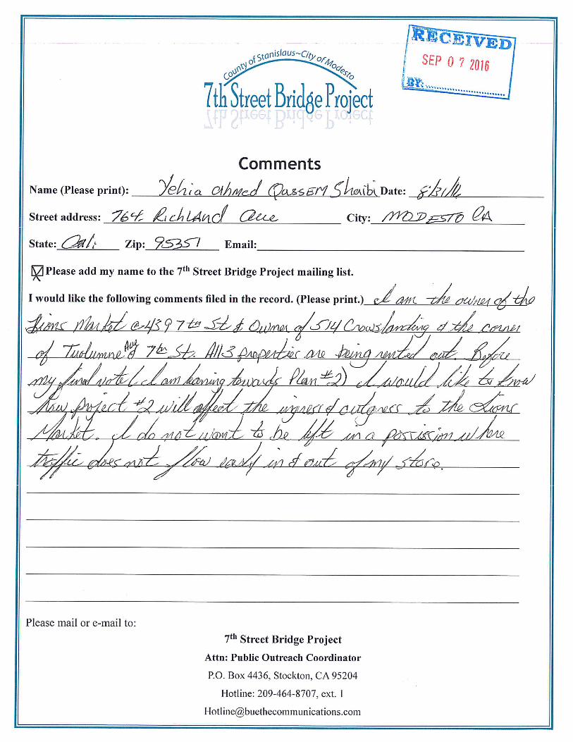
6. Letter from Yehia Ahmed Qassem Shaibi, August 31, 2016

bbell
Text Box
6
bbell
Line
bbell
Text Box
1


CHAPTER 4 COMMENTS AND RESPONSES
EN1216161130SAC CH2M HILL, INC.
Comment Letter 6: Letter from Yehia Ahmed Qassem Shaibi, August 31, 2016 Response to Comment 6-1
As described in Master Response 1, Alternative 2B is recommended for approval; this alternative would preserve Lion’s Market but would affect vehicle access and parking. In addition, Alternative 2B would require a small acquisition of approximately 0.027 acre (1,175 square feet) on the south side of the Lion’s Market property (see Draft EIR Table 2-1).
Currently, Lion’s Market is accessed directly from 7th Street and vehicles park within the frontage area; this parking area is mostly within the publicly owned County right-of-way (i.e., Stanislaus County’s property rights extend beyond the boundaries of the 7th Street roadway itself, as shown by the right-of-way boundary marker indicated on Figure 1). Alternative 2B would raise 7th Street approximately 4 feet above the existing ground level directly in front of Lion’s Market. While not impacting the building structure itself, parking in front of Lion’s Market would no longer be possible. In order to replace the lost access in front of Lion’s Market, the County would construct a new driveway just south of the market; this will provide access behind the market where new parking can be installed. Because the project would not take an existing private parking lot (existing on-street parking is within the County right of way), the County would not be responsible for installing the new parking area, just for providing access. See Draft EIR Figure 2-1A, which shows the proposed new driveway including an adjacent sidewalk.
Figure 1. View of Lion’s Market Looking South. The photograph shows the current parking area in front of the store. The approximate boundary of the Stanislaus County right-of-way (which will not change as a result of the project) is shown as a vertical line.
In summary, Lion’s Market would be preserved but parking and access would be much different. Note that the information presented in the Draft and Final EIR is based on preliminary roadway design, and is subject to modification during development of the final design, which will occur after the project approval process is complete.


EN1216161130SAC CH2M HILL, INC.
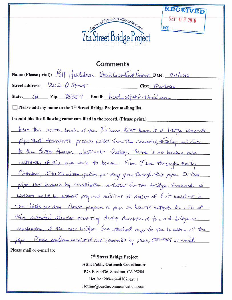
7. Letter from Bill Hudelson, September 1, 2016

bbell
Text Box
7
YS017430
Line
bbell
Text Box
1

CHAPTER 4 COMMENTS AND RESPONSES
EN1216161130SAC CH2M HILL, INC.
Comment Letter 7: Letter from Bill Hudelson, September 1, 2016 Response to Comment 7-1
Thank you for asking about the wastewater pipeline. Our utility investigation identified the pipeline and it is shown on our general plans. This pipeline will be protected and will not be affected by construction. Bridge columns and foundations have been designed to avoid it. Further design and avoidance measures will be drafted during the final design phase. Text has been added to the Draft EIR Section 5.2.7, Utilities, to specifically discuss this pipeline (see Section 3, Revisions to the Text of the Draft EIR, above).

EN1216161130SAC CH2M HILL, INC.
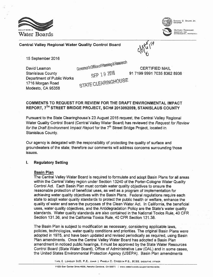
8. Letter from Central Valley Regional Water Quality Control Board,
September 15, 2016

bbell
Text Box
8
bbell
Line
bbell
Text Box
1
bbell
Text Box
8
bbell
Line
bbell
Line
bbell
Text Box
1
bbell
Text Box
2

bbell
Text Box
8
bbell
Line
bbell
Text Box
2

bbell
Text Box
8
bbell
Line
bbell
Text Box
2

bbell
Text Box
8
bbell
Line
bbell
Text Box
2

bbell
Text Box
8
CHAPTER 4 COMMENTS AND RESPONSES
EN1216161130SAC CH2M HILL, INC.
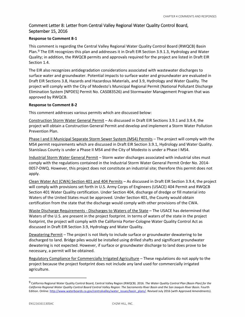
Comment Letter 8: Letter from Central Valley Regional Water Quality Control Board, September 15, 2016 Response to Comment 8-1
This comment is regarding the Central Valley Regional Water Quality Control Board (RWQCB) Basin Plan.9 The EIR recognizes this plan and addresses it in Draft EIR Section 3.9.1.3, Hydrology and Water Quality; in addition, the RWQCB permits and approvals required for the project are listed in Draft EIR Section 1.4.
The EIR also recognizes antidegradation considerations associated with wastewater discharges to surface water and groundwater. Potential impacts to surface water and groundwater are evaluated in Draft EIR Sections 3.8, Hazards and Hazardous Materials, and 3.9, Hydrology and Water Quality. The project will comply with the City of Modesto’s Municipal Regional Permit (National Pollutant Discharge Elimination System [NPDES] Permit No. CAS083526) and Stormwater Management Program that was approved by RWQCB.
Response to Comment 8-2
This comment addresses various permits which are discussed below:
Construction Storm Water General Permit – As discussed in Draft EIR Sections 3.9.1 and 3.9.4, the project will obtain a Construction General Permit and develop and implement a Storm Water Pollution Prevention Plan.
Phase I and II Municipal Separate Storm Sewer System (MS4) Permits – The project will comply with the MS4 permit requirements which are discussed in Draft EIR Section 3.9.1, Hydrology and Water Quality. Stanislaus County is under a Phase II MS4 and the City of Modesto is under a Phase I MS4.
Industrial Storm Water General Permit – Storm water discharges associated with industrial sites must comply with the regulations contained in the Industrial Storm Water General Permit Order No. 2014-0057-DWQ. However, this project does not constitute an industrial site; therefore this permit does not apply.
Clean Water Act (CWA) Section 401 and 404 Permits – As discussed in Draft EIR Section 3.9.4, the project will comply with provisions set forth in U.S. Army Corps of Engineers (USACE) 404 Permit and RWQCB Section 401 Water Quality certification. Under Section 404, discharge of dredge or fill material into Waters of the United States must be approved. Under Section 401, the County would obtain certification from the state that the discharge would comply with other provisions of the CWA.
Waste Discharge Requirements - Discharges to Waters of the State – The USACE has determined that Waters of the U.S. are present in the project footprint. In terms of waters of the state in the project footprint, the project will comply with the California Porter-Cologne Water Quality Control Act as discussed in Draft EIR Section 3.9, Hydrology and Water Quality.
Dewatering Permit – The project is not likely to include surface or groundwater dewatering to be discharged to land. Bridge piles would be installed using drilled shafts and significant groundwater dewatering is not expected. However, if surface or groundwater discharge to land does prove to be necessary, a permit will be obtained.
Regulatory Compliance for Commercially Irrigated Agriculture – These regulations do not apply to the project because the project footprint does not include any land used for commercially irrigated agriculture.
9 California Regional Water Quality Control Board, Central Valley Region (RWQCB). 2016. The Water Quality Control Plan (Basin Plan) for the California Regional Water Quality Control Board Central Valley Region: The Sacramento River Basin and the San Joaquin River Basin. Fourth Edition. Online: http://www.waterboards.ca.gov/centralvalley/water_issues/basin_plans/. Revised July 2016 (with Approved Amendments).

CHAPTER 4 COMMENTS AND RESPONSES
CH2M HILL, INC. EN1216161130SAC
Low or Limited Threat General NPDES Permit – The proposed project is not anticipated to include substantial construction dewatering nor discharge of groundwaters to waters of the United States. However, if these activities do prove to be necessary, the County will apply for a Low Threat General Order or Limited Threat General Order from RWQCB.

EN1216161130SAC CH2M HILL, INC.
9. Letter from California State Lands Commission, October 5, 2016

YS017430
Text Box
9

YS017430
Line
YS017430
Line
YS017430
Text Box
9
YS017430
Text Box
1
YS017430
Text Box
2
YS017430
Text Box
9
YS017430
Text Box
2
YS017430
Line
YS017430
Line
YS017430
Line
YS017430
Text Box
3
YS017430
Text Box
4

YS017430
Text Box
9
YS017430
Line
YS017430
Line
YS017430
Line
YS017430
Text Box
4
YS017430
Text Box
5
YS017430
Text Box
6

YS017430
Text Box
9
YS017430
Line
YS017430
Line
YS017430
Text Box
7
YS017430
Text Box
8
YS017430
Text Box
9
YS017430
Line
YS017430
Line
YS017430
Text Box
8
YS017430
Text Box
9

CHAPTER 4 COMMENTS AND RESPONSES
EN1216161130SAC CH2M HILL, INC.
Comment Letter 9: Letter from California State Lands Commission, October 5, 2016 Response to Comment 9-1
Thank you for explaining the terms of the land use lease in better detail. We modified the language of the bullet point discussing the State Lands Commission lease in Draft EIR Section 1.4 (see page 3-1 of this Final EIR) and will apply for a new lease or an amendment to the existing lease.
Response to Comment 9-2
The commenter asks about work within their jurisdiction – in other words, activities subject to the land use lease. Based on our understanding of State Lands Commission jurisdiction, the land use lease would cover project features in the area between the ordinary low water mark and the ordinary high water mark, or from approximately 44 feet to 50 feet above mean sea level, respectively. Within this area, existing Piers K and L would be removed, and new Piers 2 and 3 would be installed. For Alternative 2B, the location of the new piers is shown on Draft EIR Figure 2-3. Pier 3 would be in approximately the same location as Pier K. Pier 2, however, would be installed much closer to the river bank, approximately 50 feet south of Pier L. Pier L is in the middle of the existing river channel, but modern design standards allow for a longer span.
Construction activity also would require the use of temporary trestles and small, temporary cofferdams; both would be removed following completion of construction activity.
Response to Comment 9-3
Regarding aesthetic impacts, we currently know enough about project alternatives to conduct visual impact analyses that satisfy CEQA and Caltrans. The visual impact analyses and visual simulations were based on a basic, preliminary version of the proposed alternatives. We know the bridge design, dimensions, and building materials under consideration and so were able to assess these features. Additional finishing treatments such as color and minor architectural features, some of which have not yet been selected, would not alter the general conclusions of the visual impact analysis. In addition, these embellishments would tend to improve the visual outcome of the project and would not create new impacts.
Response to Comment 9-4
As requested, a table containing a complete list of NES AMMs, Table 3.6-1, has been created and inserted into Draft EIR Section 3.6.5 (see page 3-2 above).
Various consultation and permitting activities are required for project construction (see Draft EIR Section 1.4, Permits and Approvals). As noted by the commenter, some consultation activities are required prior to completing environmental review. In terms of biological resources, consultation is ongoing between Caltrans and the National Marine Fisheries Service, and a Biological Opinion is expected shortly. Also, the U.S. Army Corps of Engineers approved a preliminary jurisdiction determination of Waters of the United States, which is included as an appendix to the Natural Environment Study10 (see Draft EIR Appendix F). These processes are ongoing, but are expected to be completed soon based on continuing work between Caltrans, Stanislaus County, and the regulatory agencies. Stanislaus County can certify the Final EIR while these processes are still underway, but note that these processes must be completed prior to Caltrans action to complete the National Environmental Policy Act review. Other agencies have been notified of the project, and Stanislaus County will apply for other permits, as required, prior to construction.
10 California Department of Transportation (Caltrans). 2016. 7th Street Bridge Project Natural Environment Study. June.

CHAPTER 4 COMMENTS AND RESPONSES
CH2M HILL, INC. EN1216161130SAC
Response to Comment 9-5
The commenter summarizes the Draft EIR’s discussion of impacts to the historic 7th Street Bridge and proposed mitigation. In terms of the State Historic Preservation Officer (SHPO), a draft Memorandum of Agreement (MOA) has been prepared and reviewed by SHPO staff; the current language of Mitigation Measures CUL-3a and CUL-3b incorporates their suggested changes. Final adoption of the SHPO MOA is expected to occur at about the same time as Stanislaus County certifies the Final EIR. In addition, Caltrans will require the MOA to be fully executed before completing their review process under the National Environmental Policy Act.
Response to Comment 9-6
Our approach to greenhouse gas (GHG) assessment is consistent with the guidance of San Joaquin Valley Air Pollution Control District (SJVAPCD) and Caltrans. SJVAPCD does not have numerical GHG emission thresholds. SJVAPCD did not comment on the Draft EIR but indicated in the Guidance for Valley Land-use Agencies in Addressing GHG Emission Impacts for New Projects under CEQA (2009)11 and also in the latest Final Draft Guidance for Assessing and Mitigating Air Quality Impacts (2015)12 that the district does not have a numerical GHG emission threshold. The guidance suggests that significance of GHG emission impacts should be determined based on: 1) whether the project is included in an approved GHG reduction plan, 2) whether it applies Best Performance Standards, or 3) whether the project would achieve 29 percent reduction of GHG compared to business as usual. For the 7th Street Bridge Project, our conclusion of “less than significant” was based on the fact that the project is included in the region’s approved Regional Transportation Plan/Sustainable Communities Strategy (RTP/SCS), which is the region’s GHG reduction plan.
Response to Comment 9-7
A pedestrian plaza will be built as part of the project that will provide access to the Gateway Parcel of the Tuolumne River Regional Park and to the Tuolumne River itself. During the final design phase, project staff will coordinate with the Tuolumne River Regional Park Joint Powers Authority to develop a design that provides access to these features. We have updated Draft EIR Section 2.2, Overview of Alternatives, to reflect this (see page 3-1 above).
Project construction has the potential to overlap with construction of the park. Community outreach will be developed during the final design phase to notify any park users of project construction. Notification will be similar to the outreach developed under the traffic management plan discussed in MM Trans-2 in Draft EIR Section 3.1.5, Mitigation Measures.
Response to Comment 9-8
As described in the Draft EIR, the Tuolumne River is listed as impaired by mercury and other pollutants (see Table 3.9-2). The Draft EIR states that there is an approved Total Maximum Daily Load (TMDL) implementation plan for sediment, but not for the other pollutants listed in Draft EIR Table 3.9-2.
In terms of mercury, the TMDL is expected to be completed in 2021. Until the new TMDL is complete, it is not possible to articulate a quantitative threshold of significance as the commenter suggests. In our experience with TMDL waste load allocations, quantitative thresholds are usually reserved for point-source discharges (such as wastewater treatment plants) or to urban areas under a municipal regional (i.e., MS4) permit. In contrast, individual construction projects typically follow best management
11 San Joaquin Valley Air Pollution Control District (SJVAPCD). 2009. Guidance for Valley Land-use Agencies in Addressing GHG Emission Impacts for New Projects under CEQA. Online: http://www.valleyair.org/programs/ccap/12-17-09/3%20ccap%20-%20final%20lu%20guidance%20-%20dec%2017%202009.pdf. December 17.
12 San Joaquin Valley Air Pollution Control District (SJVAPCD). 2015. FINAL DRAFT Guidance for Assessing and Mitigating Air Quality Impacts. Online: http://www.valleyair.org/transportation/GAMAQI_3-19-15.pdf. March 19.

CHAPTER 4 COMMENTS AND RESPONSES
EN1216161130SAC CH2M HILL, INC.
practices (BMPs) to minimize pollutant discharges; this is the approach described under Impact HYDRO-1 in Draft EIR Section 3.9.4, Environmental Impacts. Project construction activities would occur in conformance with the Construction General Permit and subject to review under the local MS4 permit. The required Stormwater Pollution Prevention Plan would prescribe BMPs to minimize pollutant discharges from all construction activities including any necessary in-water work (e.g., cofferdam installation) that might cause sediment to be mobilized.
Note also that the Natural Environment Study includes specific measures for sediment control during construction. For example, steelhead avoidance and minimization efforts include isolating wet work areas from flowing water using cofferdams, gravel berms, or similar methods (see NES Section 4.3.2.3). These requirements are incorporated into the Draft EIR as MM BIO-1.
Response to Comment 9-9
A Mitigation Monitoring and Reporting Program (MMRP) document has been prepared, and will be considered for adoption by Stanislaus County as part of the Final EIR review and certification process.

EN1216161130SAC CH2M HILL, INC.
10. Letter from Nathan Holth, October 6, 2016

HistoricBridges.org Promoting the preservation of our transportation heritage.
October 6, 2016
David A. Leamon, PE Stanislaus County Public Works Deputy Director Construction Administration and Operations 1716 Morgan Road Modesto, CA 95358 209-525-4151 office 209-409-4733 cell
Subject: 7th Street (Lion) Bridge Memorandum of Agreement Comments
Dear Mr. Leamon:
The following are my comments for the above listed project.
National Historical Context
Firstly, I would like to recognize the historic significance of this bridge, which centers around the fact that the bridge is not a “true” arch bridge, but is instead a concrete cantilever arch bridge. As a resident of Michigan, which is home to one of the longest examples of this type, Detroit’s Belle Isle Bridge, plus several other smaller examples designed by Wayne County, I have taken a particular interest in this otherwise exceedingly rare bridge type. Aside from the 7th Street Lion Bridge in Modesto (built 1916), the only other large, multi-span bridges of this type in the entire country that I am aware of are the Vachel Lindey Bridge in Springfield, Illinois (built 1933), the approach spans of the Hanover Street Bridge in Baltimore, Maryland (built 1916), and the Belle Isle Bridge in Detroit, Michigan (built 1923). While all of these bridges share a cantilever function, and use a reinforcement of riveted trusses, these bridges can be further subdivided into classes based on the design details of their steel reinforcement. For example, the Belle Isle Bridge and the Hanover Street Bridge include a trussed/braced arch rib with eyebars that act like stays running from the crown of the arch back to the top of the pier. In contrast, the Lion Bridge, a design of San Francisco-based Leonard and Day, utilized a closed spandrel design with an underlying riveted steel truss that extends throughout the depth of the arch. This California variation has been described as “canticrete” construction. It is (based on my cursory research) tied with the Hanover Street Bridge as the oldest known surviving example of large-scale concrete cantilever arch construction in America.
I have presented the above information to establish my interpretation of the historic significance of this type of bridge. Certainly the state-level significance for the 7th Street Lion Bridge is high, and the bridge may rise to “national significance” given the rarity of concrete cantilever arch bridges of any design nationwide. How many “canticrete” bridges remain in California? I believe the Lion Bridge is the largest (and possibly one of the only) surviving examples of the canticrete design, the product of a notable in-state designer. In any case, I believe the rarity and significance of the bridge warrants extraordinary mitigation for a proposed adverse effect (demolition). I also presented the above information on this bridge type and design to help establish that what is structurally significant about this bridge isn’t just the
Nathan Holth 2767 Eastway Drive Okemos, MI 48864 269-290-2593 [email protected]
bbell
Text Box
10
YS017430
Line
bbell
Text Box
1

HistoricBridges.org Promoting the preservation of our transportation heritage.
appearance of the bridge as a concrete arch, but also the underlying steel reinforcement and the arrangement of that reinforcement. That said, I offer the following comments and ideas for additional mitigation.
Mitigation Already Proposed:
1. HAER Documentation: I recommend this include digital scans of the original drawings if they exist. Shop drawings (for the reinforcement) and site plans as well. If no original drawings exist, then I recommend HAER Measured Drawings. This bridge is rare and significant enough to warrant this classification of HAER Documentation (Level 1 HAER Documentation). The demolition of such a unique structure is an irreversible loss for which the preservation of other bridges cannot make up for. No other bridges of this design and size (canticrete subset of cantilever arch) exist to my knowledge.
2. Pedestrian Plaza: I think this is a good idea, and it goes along well with additional mitigation I outline in the next section.
3. Interpretive panels: I suggest that these be detailed, describing and showing the reinforcement, etc. Visitors should learn what a “cantilever” is and what a true “arch” is and why these spans are “cantilevers” that act differently than a true arch. A nationwide context of concrete cantilever arch bridges should be provided. I can assist with providing information, original drawings, and historical photos of some of the other bridges of this type elsewhere in the country if desired.
4. Installation of Salvaged Materials: I also think this is a good idea. However, as the proposed items for salvage are decorative elements which do not convey the bridges National Register Criterion C (Engineering/Design) significance, I have additional ideas for salvaged materials below.
Additional Suggested Mitigation
This bridge’s underlying steel reinforcement is the source of its unusual design. Unlike modern rebar, it is a self-supporting riveted steel truss. Historical photos of this bridge type (an under-construction photo of another canticrete bridge in California shows this). My suggestion is to have one portion of the bridge superstructure demolished more carefully in a way which would remove the concrete but not destroy the steel reinforcement. Not sure of the method, perhaps hydrodemolition or some other less destructive method. “Dropping” the span in the river as proposed in the
project documentation would need to be avoided for this portion. This salvaged steel structure would then be incorporated into the kiosk. In terms of how much and exactly what parts should be salvaged I suggest be determined by cost, visually appearance, and ability to convey the cantilever function. This might be one “arch” of reinforcing (and potentially additional reinforcing from adjacent spans to maintain and demonstrate balance). The arch could be artistically incorporated (ie an arch you walk under to enter the kiosk area). In terms of portions salvaged, it might also be two “arms” of reinforcement as they extend from either end of each pier as self-supporting cantilever arms.
I realize removing, cleaning, painting, and reusing the steel reinforcement from even a single span likely represents a fair amount of effort. Indeed, it is my assumption that no more than one or two spans might
YS017430
Line
YS017430
Line
YS017430
Line
bbell
Text Box
1
bbell
Text Box
2
bbell
Text Box
3
bbell
Text Box
10
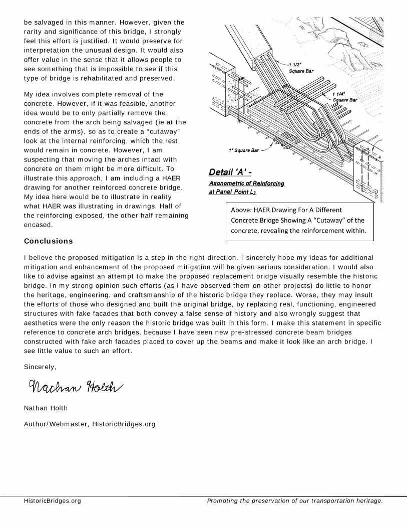
HistoricBridges.org Promoting the preservation of our transportation heritage.
be salvaged in this manner. However, given the rarity and significance of this bridge, I strongly feel this effort is justified. It would preserve for interpretation the unusual design. It would also offer value in the sense that it allows people to see something that is impossible to see if this type of bridge is rehabilitated and preserved.
My idea involves complete removal of the concrete. However, if it was feasible, another idea would be to only partially remove the concrete from the arch being salvaged (ie at the ends of the arms), so as to create a “cutaway” look at the internal reinforcing, which the rest would remain in concrete. However, I am suspecting that moving the arches intact with concrete on them might be more difficult. To illustrate this approach, I am including a HAER drawing for another reinforced concrete bridge. My idea here would be to illustrate in reality what HAER was illustrating in drawings. Half of the reinforcing exposed, the other half remaining encased.
Conclusions
I believe the proposed mitigation is a step in the right direction. I sincerely hope my ideas for additional mitigation and enhancement of the proposed mitigation will be given serious consideration. I would also like to advise against an attempt to make the proposed replacement bridge visually resemble the historic bridge. In my strong opinion such efforts (as I have observed them on other projects) do little to honor the heritage, engineering, and craftsmanship of the historic bridge they replace. Worse, they may insult the efforts of those who designed and built the original bridge, by replacing real, functioning, engineered structures with fake facades that both convey a false sense of history and also wrongly suggest that aesthetics were the only reason the historic bridge was built in this form. I make this statement in specific reference to concrete arch bridges, because I have seen new pre-stressed concrete beam bridges constructed with fake arch facades placed to cover up the beams and make it look like an arch bridge. I see little value to such an effort.
Sincerely,
Nathan Holth
Author/Webmaster, HistoricBridges.org
Above: HAER Drawing For A Different Concrete Bridge Showing A “Cutaway” of the concrete, revealing the reinforcement within.
YS017430
Line
YS017430
Line
bbell
Text Box
3
bbell
Text Box
4
bbell
Text Box
10

CHAPTER 4 COMMENTS AND RESPONSES
EN1216161130SAC CH2M HILL, INC.
Comment Letter 10: Letter from Nathan Holth, October 6, 2016 Response to Comment 10-1
The commenter discusses the historical significance of the 7th Street Bridge, including information that corroborates Stanislaus County’s technical studies (summarized in Section 3.7.2 of the Draft EIR). Stanislaus County agrees with the commenter’s statements about the bridge.
Response to Comment 10-2
The commenter summarizes the proposed mitigation and offers suggestions. Responses to each suggestion are as follows.
• Mitigation Measure CUL-3a requires that the existing bridge be documented following the standards of the Historic American Engineering Record (HAER). The commenter suggests items to include in the HAER report, including digital scans of the original drawings. Digital scans of the as-built construction drawings are available from Stanislaus County, and will be included in the HAER report. Note also that a detailed photo-simulation of the existing bridge using light detection and ranging (LIDAR) technology was prepared in 2015. As described in Mitigation Measure CUL-3b, LIDAR simulations and animations will be included in the HAER report and made available to the public.
• The pedestrian plaza is a key project feature, and the Draft EIR project description has been updated to include specific language about the plaza (see page 3-1 above).
• As a consulting party, the commenter will have an opportunity to review the final pedestrian plaza design, including text used for the interpretive panels. Stanislaus County will reach out to the commenter when the final design process begins.
• The commenter introduces his suggestion to use salvaged materials in the pedestrian plaza. See detailed Response to Comment 10-3 below.
Response to Comment 10-3
The commenter suggests that the plaza be modified to include an additional feature: an interpretive display of a salvaged portion of the existing bridge structure. This display would include the exposed steel reinforcement, which is currently encased in concrete – in other words, a cutaway that reveals the internal structure of the “canticrete” (i.e., having cantilevered steel trusses encased in concrete) bridge.
The County agrees with this suggestion, and as previously noted on page 3-7 above, Draft EIR Mitigation Measure CUL-3b (second bullet) has been updated as follows:13
• Stanislaus County shall investigate the feasibility of removing historic elements from the 7th Street Bridge prior to its demolition. If feasible, Stanislaus County shall remove the selected features and install them within the pedestrian plaza. These features may include one or more of the concrete lions, railing/bench segments, an obelisk, and one or more of the bridge’s bronze plaques. The concrete lion(s) installed in the pedestrian plaza may be replicated from an original if it is determined that the historic lions are too deteriorated. The plaza also will include a salvaged portion of the existing bridge that shows the underlying steel structure supporting the “canticrete” bridge design. This salvaged cutaway will be selected to show how the original bridge design featured an internal steel structure encased in concrete. Interpretation of the cutaway should include images of the original bridge design drawings, if those images are available, and otherwise will follow the requirements for interpretive exhibits described above. Stanislaus County shall ensure that the selected features are adequately stored and protected during the interim between their removal
13 Note that this update will also be incorporated into other documents as needed, including the Memorandum of Agreement that documents the County’s (and Caltrans’) adherence to the National Historic Preservation Act.

CHAPTER 4 COMMENTS AND RESPONSES
CH2M HILL, INC. EN1216161130SAC
and installation in the pedestrian plaza. The selected features shall be installed in the pedestrian plaza within 12 months of the completion of the new 7th Street Bridge.
Details about the salvage operation, integration of the salvaged material into the plaza, and interpretation will be developed during final design and in consultation with the construction contractor (to be selected later). Please note, however, that the salvaged material will not be at the scale suggested by the commenter (“one or two spans”); given the minimum 54-foot span length, this would be cost-prohibitive and would overwhelm the plaza. The final design will specify that the area to be salvaged will be a reasonably sized representation of the steel structure underlying the canticrete bridge.
Response to Comment 10-4
This summary comment is addressed in the responses above. Stanislaus County looks forward to working with the commenter during final design.

EN1216161130SAC CH2M HILL, INC.
11. Letter from Gracie Marx, October 10, 2016


Comments
ame (Please print): .....:,,,G-=::.-Lr--.3oa"'-""c~,__...' C.-~M_;;.__t_ ... a ....!_r-,Cx: _______ Date: /0 I I) - ~ o '"
Str et address: '+14 Tb O f/Y\ pso h Wa\./ ' 1
City: 'f= 5c...al OY)
State: CA Zip: 953.:l.o Email: 3rac/c,1to'C:}i ~ -aol ' C.C> CY)
0 Please add my name to the 7th Street Bridge Project mailing list.
I would like the foUowing comments filed in the record. (Please print.) _________ _
C.b1/d. }£ ±J,e, J0<1roc.y t1
oclwded f--hL 7 7H
,$ F b ci ~e. 1 L! .. .2 D ( l ) f LI n d ,' s c.r ,· h ab le l T_h !:.
childhood, e1ea5C'.'.rl) please kee.,p ±he or,dY\d\ \ t'oV'ls, Do no-i- C.ban:;e ±he- 6r,'dae.- Teo
Attn: Public Outreach Coordinator
P.O. Box 773, Stockton, CA 95201-0773
Hotline: 209-464-8707, ext. 101
bbell
Text Box
11
YS017430
Line
YS017430
Text Box
1

CHAPTER 4 COMMENTS AND RESPONSES
EN1216161130SAC CH2M HILL, INC.
Comment Letter 11: Letter from Gracie Marx, October 10, 2016 Response to Comment 11-1
Thank you for your comment. One alternative (Alternative 4) that was under consideration would have retrofitted the existing 7th Street Bridge and constructed a new, two-lane bridge just downstream of the existing bridge. That alternative is not being carried forward for adoption; as described in Master Response 1, Stanislaus County is recommending construction of Alternative 2B.
A project alternative that maintains the existing 7th Street Bridge for bicycle and pedestrian use was initially considered based on public feedback during the scoping process (see Draft EIR Section 2.5.2). This alternative would require construction of a new downstream bridge for vehicle traffic only and would require retrofit of the existing bridge similar to Alternative 4, for structural safety. As described in the Response to Comment 5-1 above, this alternative was not carried forward for detailed consideration.
Regarding the lions, early on it was determined that the lions would not be appropriate to the style of the new bridge and that lions would be placed instead in the new pedestrian plaza. As discussed in MM CUL-3 in Draft EIR Section 3.7.5, Stanislaus County will install one or more of the concrete lions in the new pedestrian plaza that will be created as part of this project. However, if the original lions are determined to be too deteriorated, replicas will be created and installed. Text has been added to Draft EIR Section 2.2, Overview of Alternatives, to reflect this (see page 3-1 above).


![[XLS] · Web view0781 THOROUGHFARE BOND 0783 STREET BOND 0790 CUMULATIVE BRIDGE 0791 CUMULATIVE BRIDGE & STREET 0792 ...](https://static.fdocuments.in/doc/165x107/5b025b757f8b9a952f8fc77b/xls-view0781-thoroughfare-bond-0783-street-bond-0790-cumulative-bridge-0791-cumulative.jpg)