Filling the Gap - Integrating Nodes and Streamer Data for ... · for this example, a large gap of...
5
EAGE 68 th Conference & Exhibition — Vienna, Austria, 12 - 15 June 2006 B042 Filling the Gap - Integrating Nodes and Streamer Data for Geophysical Monitoring Purposes E. Ceragioli* (TOTAL SA), A. Kabbej (TOTAL SA), A. Gonzalez Carballo (TOTAL E&P ANGOLA) & D. Marin (CGG) SUMMARY In the recent past, various tests and related publications have demonstrated that high quality data can be acquired with a relatively sparse distribution of seismic nodes on the ocean bottom. One of the possible applications of this promising geophysical technology is to use it as a complement to streamer data, to fill in sensitive areas where conventional marine or OBC acquisitions are unfeasible or too risky from a HSE point of view. In this paper, we assess the feasibility of such a joint streamer - nodes approach for the geophysical monitoring of an ultra deep water oil and gas field. We develop a methodology for the planning of a joint survey, taking into account the different nature of the two sets of data, as well as other relevant operational constraints. We validate both joint time and depth pre stack migration schemes, resolving the problem of the datum difference between ocean bottom and sea surface data. We evaluate the impact of this merged approach on the interpretation of resulting seismic amplitudes, focussing on the time lapse characterization of turbidite fairways.
Transcript of Filling the Gap - Integrating Nodes and Streamer Data for ... · for this example, a large gap of...
EAGE 68th Conference & Exhibition — Vienna, Austria, 12 - 15 June 2006
B042Filling the Gap - Integrating Nodes andStreamer Data for GeophysicalMonitoring PurposesE. Ceragioli* (TOTAL SA), A. Kabbej (TOTAL SA), A. Gonzalez Carballo (TOTAL E&PANGOLA) & D. Marin (CGG)
SUMMARYIn the recent past, various tests and related publications have demonstrated that highquality data can be acquired with a relatively sparse distribution of seismic nodes onthe ocean bottom.One of the possible applications of this promising geophysical technology is to use it asa complement to streamer data, to fill in sensitive areas where conventional marine orOBC acquisitions are unfeasible or too risky from a HSE point of view.In this paper, we assess the feasibility of such a joint streamer - nodes approach forthe geophysical monitoring of an ultra deep water oil and gas field. We develop a methodology for the planning of a joint survey, taking into account thedifferent nature of the two sets of data, as well as other relevant operationalconstraints.We validate both joint time and depth pre stack migration schemes, resolving theproblem of the datum difference between ocean bottom and sea surface data.We evaluate the impact of this merged approach on the interpretation of resultingseismic amplitudes, focussing on the time lapse characterization of turbidite fairways.
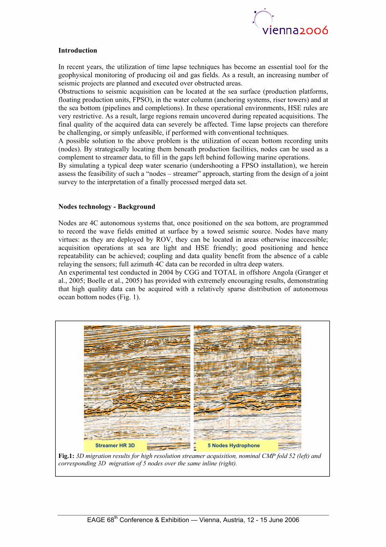
Introduction In recent years, the utilization of time lapse techniques has become an essential tool for the geophysical monitoring of producing oil and gas fields. As a result, an increasing number of seismic projects are planned and executed over obstructed areas. Obstructions to seismic acquisition can be located at the sea surface (production platforms, floating production units, FPSO), in the water column (anchoring systems, riser towers) and at the sea bottom (pipelines and completions). In these operational environments, HSE rules are very restrictive. As a result, large regions remain uncovered during repeated acquisitions. The final quality of the acquired data can severely be affected. Time lapse projects can therefore be challenging, or simply unfeasible, if performed with conventional techniques. A possible solution to the above problem is the utilization of ocean bottom recording units (nodes). By strategically locating them beneath production facilities, nodes can be used as a complement to streamer data, to fill in the gaps left behind following marine operations. By simulating a typical deep water scenario (undershooting a FPSO installation), we herein assess the feasibility of such a “nodes – streamer” approach, starting from the design of a joint survey to the interpretation of a finally processed merged data set. Nodes technology - Background Nodes are 4C autonomous systems that, once positioned on the sea bottom, are programmed to record the wave fields emitted at surface by a towed seismic source. Nodes have many virtues: as they are deployed by ROV, they can be located in areas otherwise inaccessible; acquisition operations at sea are light and HSE friendly; good positioning and hence repeatability can be achieved; coupling and data quality benefit from the absence of a cable relaying the sensors; full azimuth 4C data can be recorded in ultra deep waters. An experimental test conducted in 2004 by CGG and TOTAL in offshore Angola (Granger et al., 2005; Boelle et al., 2005) has provided with extremely encouraging results, demonstrating that high quality data can be acquired with a relatively sparse distribution of autonomous ocean bottom nodes (Fig. 1).
Streamer HR 3D 5 Nodes Hydrophone
Fig.1: 3D migration results for high resolution streamer acquisition, nominal CMP fold 52 (left) and corresponding 3D migration of 5 nodes over the same inline (right).
EAGE 68th Conference & Exhibition — Vienna, Austria, 12 - 15 June 2006
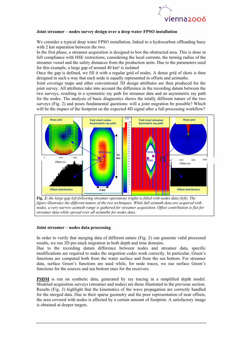
Joint streamer – nodes survey design over a deep water FPSO installation We consider a typical deep water FPSO installation, linked to a hydrocarbon offloading buoy with 2 km separation between the two. In the first phase, a streamer acquisition is designed to box the obstructed area. This is done in full compliance with HSE restrictions, considering the local currents, the turning radius of the streamer vessel and the safety distances from the production units. Due to the parameters used for this example, a large gap of around 40 km² is isolated Once the gap is defined, we fill it with a regular grid of nodes. A dense grid of shots is then designed in such a way that each node is equally represented in offsets and azimuths. Joint coverage maps and other conventional 3D design attributes are then produced for the joint survey. All attributes take into account the difference in the recording datum between the two surveys, resulting in a symmetric ray path for streamer data and an asymmetric ray path for the nodes. The analysis of basic diagnostics shows the totally different nature of the two surveys (Fig. 2) and poses fundamental questions: will a joint migration be possible? Which will be the impact of the footprint on the expected 4D signal after a full processing workflow?
Rose plot Rose plot Fold chart nodes Asymmetric ray path
Fold chart streamer Symmetric ray path
SPM Buoy SPM Buoy 12 km 0 2000 4000
FPSO 0 FPSO 2000 4000 Offset (m) Offset (m)
Offset distribution Offset distribution 3 km
Fig. 2: the large gap left following streamer operations (right) is filled with nodes data (left). The figure illustrates the different nature of the two techniques. While full azimuth data are acquired with nodes, a very narrow azimuth range is gathered for streamer acquisition. Offset contribution is flat for streamer data while spread over all azimuths for nodes data.
6000
Joint streamer – nodes data processing In order to verify that merging data of different nature (Fig. 2) can generate valid processed results, we run 3D pre-stack migration in both depth and time domains. Due to the recording datum difference between nodes and streamer data, specific modifications are required to make the migration codes work correctly. In particular, Green’s functions are computed both from the water surface and from the sea bottom. For streamer data, surface Green’s functions are used while, for node traces, we use surface Green’s functions for the sources and sea bottom ones for the receivers. PSDM is run on synthetic data, generated by ray tracing in a simplified depth model. Modeled acquisition surveys (streamer and nodes) are those illustrated in the previous section. Results (Fig. 3) highlight that the kinematics of the wave propagation are correctly handled for the merged data. Due to their sparse geometry and the poor representation of near offsets, the area covered with nodes is affected by a certain amount of footprint. A satisfactory image is obtained at deeper targets.
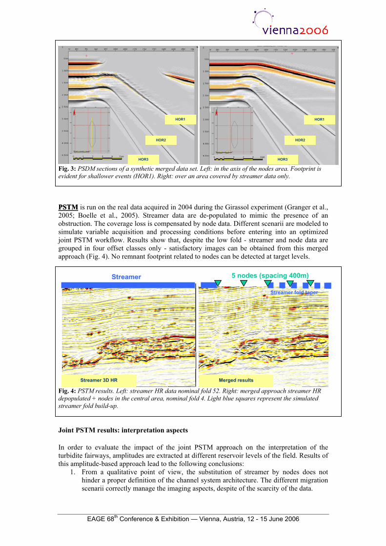
HOR1 HOR1
HOR2 HOR2
HOR3 HOR3
Fig. 3: PSDM sections of a synthetic merged data set. Left: in the axis of the nodes area. Footprint is evident for shallower events (HOR1). Right: over an area covered by streamer data only. PSTMPSTM is run on the real data acquired in 2004 during the Girassol experiment (Granger et al., 2005; Boelle et al., 2005). Streamer data are de-populated to mimic the presence of an obstruction. The coverage loss is compensated by node data. Different scenarii are modeled to simulate variable acquisition and processing conditions before entering into an optimized joint PSTM workflow. Results show that, despite the low fold - streamer and node data are grouped in four offset classes only - satisfactory images can be obtained from this merged approach (Fig. 4). No remnant footprint related to nodes can be detected at target levels.
5 nodes (spacing 400m) Streamer
Streamer 3D HR Merged results
Fig. 4: PSTM results. Left: streamer HR data nominal fold 52. Right: merged approach streamer HR depopulated + nodes in the central area, nominal fold 4. Light blue squares represent the simulated streamer fold build-up.
Streamer fold taper
Joint PSTM results: interpretation aspects In order to evaluate the impact of the joint PSTM approach on the interpretation of the turbidite fairways, amplitudes are extracted at different reservoir levels of the field. Results of this amplitude-based approach lead to the following conclusions:
1. From a qualitative point of view, the substitution of streamer by nodes does not hinder a proper definition of the channel system architecture. The different migration scenarii correctly manage the imaging aspects, despite of the scarcity of the data.
EAGE 68th Conference & Exhibition — Vienna, Austria, 12 - 15 June 2006
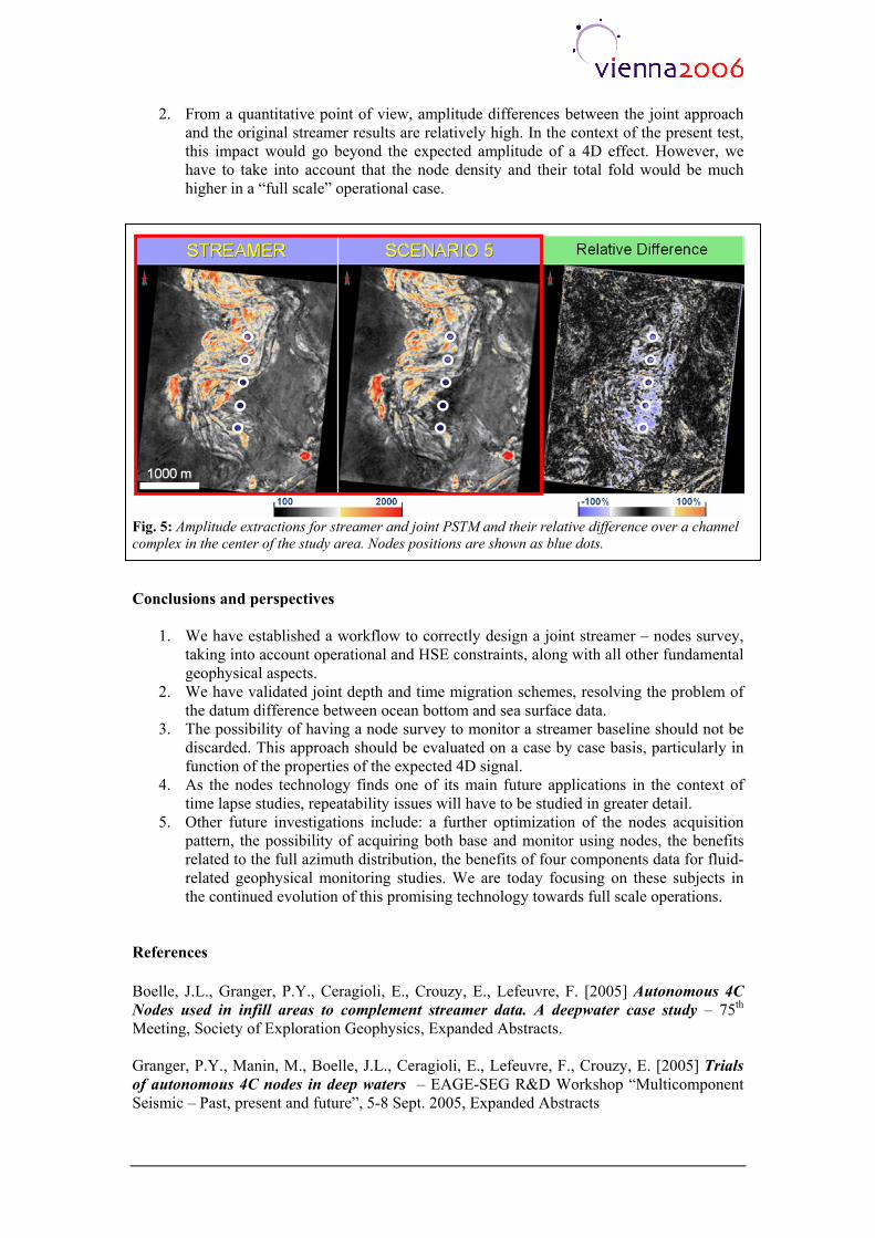
2. From a quantitative point of view, amplitude differences between the joint approach and the original streamer results are relatively high. In the context of the present test, this impact would go beyond the expected amplitude of a 4D effect. However, we have to take into account that the node density and their total fold would be much higher in a “full scale” operational case.
Fig. 5: Amplitude extractions for streamer and joint PSTM and their relative difference over a channel complex in the center of the study area. Nodes positions are shown as blue dots. Conclusions and perspectives
1. We have established a workflow to correctly design a joint streamer – nodes survey, taking into account operational and HSE constraints, along with all other fundamental geophysical aspects.
2. We have validated joint depth and time migration schemes, resolving the problem of the datum difference between ocean bottom and sea surface data.
3. The possibility of having a node survey to monitor a streamer baseline should not be discarded. This approach should be evaluated on a case by case basis, particularly in function of the properties of the expected 4D signal.
4. As the nodes technology finds one of its main future applications in the context of time lapse studies, repeatability issues will have to be studied in greater detail.
5. Other future investigations include: a further optimization of the nodes acquisition pattern, the possibility of acquiring both base and monitor using nodes, the benefits related to the full azimuth distribution, the benefits of four components data for fluid-related geophysical monitoring studies. We are today focusing on these subjects in the continued evolution of this promising technology towards full scale operations.
References Boelle, J.L., Granger, P.Y., Ceragioli, E., Crouzy, E., Lefeuvre, F. [2005] Autonomous 4C Nodes used in infill areas to complement streamer data. A deepwater case study – 75th Meeting, Society of Exploration Geophysics, Expanded Abstracts. Granger, P.Y., Manin, M., Boelle, J.L., Ceragioli, E., Lefeuvre, F., Crouzy, E. [2005] Trials of autonomous 4C nodes in deep waters – EAGE-SEG R&D Workshop “Multicomponent Seismic – Past, present and future”, 5-8 Sept. 2005, Expanded Abstracts