Fauquier County Heritage Resources An Overview
19
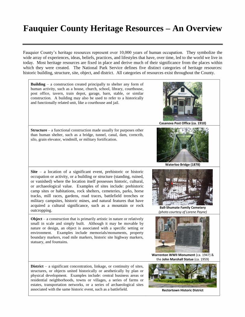
Fauquier County Heritage Resources – An Overview Fauquier County’s heritage resources represent over 10,000 years of human occupation. They symbolize the wide array of experiences, ideas, beliefs, practices, and lifestyles that have, over time, led to the world we live in today. Most heritage resources are fixed in place and derive much of their significance from the places within which they were created. The National Park Service defines five distinct categories of heritage resources: historic building, structure, site, object, and district. All categories of resources exist throughout the County. Building – a construction created principally to shelter any form of human activity, such as a house, church, school, library, courthouse, post office, tavern, train depot, garage, barn, stable, or similar construction. A building may also be used to refer to a historically and functionally related unit, like a courthouse and jail. Casanova Post Office (ca. 1910) Structure – a functional construction made usually for purposes other than human shelter, such as a bridge, tunnel, canal, dam, corncrib, silo, grain elevator, windmill, or military fortification. Waterloo Bridge (1878) Site – a location of a significant event, prehistoric or historic occupation or activity, or a building or structure (standing, ruined, or vanished) where the location itself possesses historic, cultural, or archaeological value. Examples of sites include: prehistoric camp sites or habitations, rock shelters, cemeteries, parks, horse tracks, mill races, gardens, road traces, battlefield trenches or military campsites, historic mines, and natural features that have acquired a cultural significance, such as a mountain or rock outcropping. Ball-Shumate Family Cemetery (photo courtesy of Lorene Payne) Object – a construction that is primarily artistic in nature or relatively small in scale and simply built. Although it may be movable by nature or design, an object is associated with a specific setting or environment. Examples include memorials/monuments, property boundary markers, road mile markers, historic site highway markers, statuary, and fountains. Warrenton WWII Monument (ca. 1947) & the John Marshall Statue (ca. 1959) District – a significant concentration, linkage, or continuity of sites, structures, or objects united historically or aesthetically by plan or physical development. Examples include: central business areas or residential neighborhoods, towns or villages, a series of farms or estates, transportation networks, or a series of archaeological sites associated with the same historic event, such as a battlefield. Rectortown Historic District
Transcript of Fauquier County Heritage Resources An Overview
Fauquier County Heritage Resources – An Overview
Fauquier County’s heritage resources represent over 10,000 years of human occupation. They symbolize the
wide array of experiences, ideas, beliefs, practices, and lifestyles that have, over time, led to the world we live in
today. Most heritage resources are fixed in place and derive much of their significance from the places within
which they were created. The National Park Service defines five distinct categories of heritage resources:
historic building, structure, site, object, and district. All categories of resources exist throughout the County.
Building – a construction created principally to shelter any form of
human activity, such as a house, church, school, library, courthouse,
post office, tavern, train depot, garage, barn, stable, or similar
construction. A building may also be used to refer to a historically
and functionally related unit, like a courthouse and jail.
Casanova Post Office (ca. 1910)
Structure – a functional construction made usually for purposes other
than human shelter, such as a bridge, tunnel, canal, dam, corncrib,
silo, grain elevator, windmill, or military fortification.
Waterloo Bridge (1878)
Site – a location of a significant event, prehistoric or historic
occupation or activity, or a building or structure (standing, ruined,
or vanished) where the location itself possesses historic, cultural,
or archaeological value. Examples of sites include: prehistoric
camp sites or habitations, rock shelters, cemeteries, parks, horse
tracks, mill races, gardens, road traces, battlefield trenches or
military campsites, historic mines, and natural features that have
acquired a cultural significance, such as a mountain or rock
outcropping. Ball-Shumate Family Cemetery
(photo courtesy of Lorene Payne)
Object – a construction that is primarily artistic in nature or relatively
small in scale and simply built. Although it may be movable by
nature or design, an object is associated with a specific setting or
environment. Examples include memorials/monuments, property
boundary markers, road mile markers, historic site highway markers,
statuary, and fountains.
Warrenton WWII Monument (ca. 1947) & the John Marshall Statue (ca. 1959)
District – a significant concentration, linkage, or continuity of sites,
structures, or objects united historically or aesthetically by plan or
physical development. Examples include: central business areas or
residential neighborhoods, towns or villages, a series of farms or
estates, transportation networks, or a series of archaeological sites
associated with the same historic event, such as a battlefield. Rectortown Historic District

Appendix II Fauquier County Heritage Resources—An Overview
Page 2
The National Park Service has also categorized a very distinctive type of heritage resource—the cultural
landscape. Because a cultural landscape can include some or all of the five different resource categories
described above, it is defined separately. (A historic district is always considered a cultural landscape.)
Cultural Landscape – a geographic area, including both cultural and natural resources and the wildlife or
domestic animals therein, associated with a historic event, activity, or person, or that exhibits other cultural or
aesthetic values.
Cultural landscapes can range from thousands of acres of rural land to a small, urban lot with a lawn of less than
one acre. Character-defining features or distinctive characteristics of cultural landscapes include: historic
buildings; archaeological sites; trees, plants, and other vegetation; natural features that have cultural
significance, like mountains, hills, rivers, and streams; land use or spatial patterns between features; decorative
details, such as statuary or ornamental benches; and utilitarian features, like roads, fences, walls, or sidewalks.
“Reading” a cultural landscape is identifying all manmade features and culturally-significant natural features on
a landscape—even those that are the most ordinary or easily overlooked—and determining the reason for their
presence or how they were used in the past. Whether a dirt road, well, stone wall, agricultural field, orchard,
stream, hill, cemetery, bridge, barn, silo, or house, a feature is potentially considered a contributing element of a
cultural landscape if its cultural significance can be justified and tied to an area of significance or historic theme
(for example, community settlement, agricultural development, or transportation history). Also, one can expect
cultural landscapes to evolve over time. For instance, a village may retain no standing buildings from its earliest
settlement period, but the original street layout may still be visible, or a battlefield may show softened contours
and agricultural fields where there were once trenches and rifle pits. The changes that come with landscape
evolution do not necessarily harm the integrity of a cultural landscape.
Generally, there are four types of cultural landscapes, which are not mutually exclusive: vernacular landscape,
designed landscape, historic site, and ethnographic landscape.
1. Vernacular Landscape – a landscape whose use, construction or physical layout reflects endemic
traditions, customs, or values. This type of landscape expresses cultural values, social behavior, and
individual actions of the everyday lives of people over time. It is manifested in cultural and physical
features and their interrelationships, including patterns of spatial organization, land use, circulation,
vegetation, structures, and objects. Function plays a significant role in vernacular landscapes, which can
be a single property (e.g., a historic farm) or a collection of properties (e.g., a district of historic farms
along a river). Examples include historic villages, agricultural landscapes (rural historic districts), and
historic highway corridors.
2. Designed Landscape – a landscape that was consciously designed or laid out by a landscape architect,
master gardener, architect, or horticulturist according to design principles, or a property owner or an
amateur gardener working in a recognized style or tradition. This landscape may be associated with a
significant person(s), trend, or movement in landscape architecture; or illustrate an important
development in the theory and practice of landscape architecture. Aesthetic values play a significant
role in designed landscapes. Examples include designed parks & cemeteries, school campuses, and
estates.
3. Historic Site – a landscape significant for its association with a historic event, activity, or person, such
as a historic house site or battlefield.
4. Ethnographic Landscape – a landscape containing a variety of natural and cultural resources that
associated people define as heritage resources. Examples include religious sacred sites and massive
geological features that have cultural significance. Small plant communities, animals, subsistence and
ceremonial grounds are often components.

Appendix II Fauquier County Heritage Resources—An Overview
Page 3
The Fauquier County Heritage Resource Inventory
The Fauquier County Heritage Resource Inventory serves as a comprehensive County-wide database of heritage
resources that have been surveyed and recorded within the County’s present boundaries. Since the early 1970s,
architectural and archaeological resources have been recorded through the Virginia Department of Historic
Resources (DHR). At this time, the Fauquier County Heritage Resource Inventory, stored as an Excel
spreadsheet and as a layer in the County’s GIS database, is the most inclusive repository of cultural resource
data in the County. However, there are still many resources that have yet to be identified and recorded. As of
September 1, 2015, roughly 4,100 historic architectural properties and 327 archaeological sites are represented
in the Inventory, including those resources identified as components of the rural historic districts and village and
town historic districts. It should be noted that not all resources in the Inventory are currently extant.
An Overview of Resources
The following is an overview of the various cultural and historic resource types that have been identified in
Fauquier County to date. This overview is not intended to be an exhaustive description of resources in the
County or a scholarly history. Rather, the following is meant to give readers a sense of the wide range of the
heritage resources that are unique to the County and offer more challenges in terms of their identification,
documentation, management, and stewardship.
BUILDINGS
Historic buildings are tangible links with the past. They help give a community a sense of stability and
orientation. The Fauquier County Heritage Resource Inventory includes an extensive collection of historic
residential, commercial, religious, educational, and public buildings, dating from the mid-18th century through
the 20th century. They include houses, agricultural outbuildings, churches, stores, schools, taverns and
ordinaries, mills, train depots and other railroad-related buildings, gas stations, libraries, hospitals, fire stations,
theaters, office buildings, warehouses, and courthouses & other civic buildings. Structural systems and building
materials vary.
The use of particular building materials depended on many factors, including material availability at the
construction site; ease of material transportation; popular building trends and styles at the time of construction;
and material expense. Some of the County’s earliest buildings were made of log (now representing only 1% of
the architectural Inventory) and stone (10%). Brick buildings represent about 12% of the architectural
Inventory, and cementitious or concrete block buildings represent roughly 3%. The majority of historic
buildings recorded in the Inventory are wood frame (74%).
Houses
Houses and residential districts are by far the most predominant
categories of architectural resources recorded in Fauquier
County, comprising over 75 percent of the total number of
buildings in the Inventory. Because they are important centers
of private life, houses provide a strong source of cultural
history. That is, houses tell more about our societal values and
use of space than perhaps any other type of heritage resource.
They also constitute a highly diverse group of historic buildings.
Historic house architectural styles represented in the Inventory
include: Colonial (generally pre-1740), Georgian (ca. 1750-
1800), Federal (ca. 1790-1820), Classical Revival (ca. 1790-
1830), Greek Revival (ca. 1825-1850), Gothic Revival
Oak Hill This Classical Revival addition to Oak Hill, the
home of Chief Justice John Marshall, was constructed around 1819.
Photo courtesy of the Library of Congress Historic American Building Survey Collection, 1934
Appendix II Fauquier County Heritage Resources—An Overview
Page 4
(ca. 1840-1870), Italianate (1840-1885), Second Empire (ca. 1860-1885), Queen Anne (ca. 1880-1910), Shingle
(ca. 1880-1900), Colonial Revival (ca. 1890-1955), Tudor Revival (ca. 1890-1940), Craftsman (ca. 1910-1930),
Moderne (ca. 1920-1940), Minimal Traditional or Economical Small House (ca. 1940-1960), Ranch (ca. 1960-
1985), and Post Modern (1975-present). The majority of recorded Fauquier County historic houses are
classified as “Other,” which usually translates to not fitting into a single architectural style or exhibiting a
combination of styles. Also, many Fauquier County historic houses have been recorded as vernacular buildings,
which do not generally exhibit specific exterior stylistic elements but present local and regional traditional
building features.
Some historic houses have been recorded as house types. Rather than using stylistic features and ornamentation
for classification, house types are defined by the overall form or massing of the house and general interior layout
or arrangement. The number and location of doorways, windows, and chimneys, roof shape, and location of
porches may be secondary characteristics. Common house types represented in the Fauquier County
architectural Inventory include: the I-house, American Four Square, and the bungalow. Common historic house
forms identified in the Inventory are the L-Plan and T-Plan, and three most used interior plans include the hall
and parlor, side passage, and the center hall.
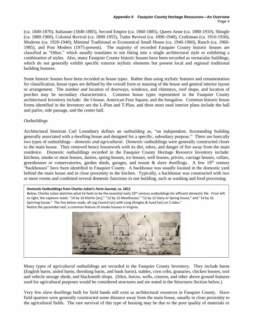
Outbuildings
Architectural historian Carl Lounsbury defines an outbuilding as, “an independent, freestanding building
generally associated with a dwelling house and designed for a specific, subsidiary purpose.” There are basically
two types of outbuildings—domestic and agricultural. Domestic outbuildings were generally constructed closer
to the main house. They removed heavy housework with its dirt, odors, and danger of fire away from the main
residence. Domestic outbuildings recorded in the Fauquier County Heritage Resource Inventory include:
kitchens, smoke or meat houses, dairies, spring houses, ice houses, well houses, privies, carriage houses, cellars,
greenhouses or conservatories, garden sheds, garages, and tenant & slave dwellings. A few 19th century
“backhouses” have been identified in Fauquier County. A backhouse was usually located in the domestic yard
behind the main house and in close proximity to the kitchen. Typically, a backhouse was constructed with two
or more rooms and combined several domestic functions in one building, such as washing and food processing.
Many types of agricultural outbuildings are recorded in the Fauquier County Inventory. They include barns
(English barns, aisled barns, threshing barns, and bank barns), stables, corn cribs, granaries, chicken houses, tool
and vehicle storage sheds, and blacksmith shops. (Silos, fences, wells, cisterns, and other above ground features
used for agricultural purposes would be considered structures and are noted in the Structures Section below.)
Very few slave dwellings built for field hands still exist as architectural resources in Fauquier County. Slave
field quarters were generally constructed some distance away from the main house, usually in close proximity to
the agricultural fields. The rare survival of this type of housing may be due to the poor quality of materials or
Domestic Outbuildings from Charles Julian’s Farm Journal, ca. 1812 Below, Charles Julian sketches what he feels to be the essential early 19th century outbuildings for efficient domestic life. From left to right, the captions reads: “14 by 16 Kitchin [sic],” “12 by 12 Meathouse,” “12 by 12 Dairy or Spring house,” and “14 by 16 Spinning house.” The line below reads: all Log Coverd [sic] with Long Shingles & hued [sic] on 2 sides.” Notice the pyramidal roof, a common feature of smoke houses in Virginia.

Appendix II Fauquier County Heritage Resources—An Overview
Page 5
construction techniques used. It is also possible that many of these buildings were demolished after the Civil
War. Some of them may survive as archaeological sites. Numerous examples of housing for domestic slaves
still exist in Fauquier County. Domestic slave houses tended to be of better quality than those for field slaves.
Scholars have suggested reasons for this occurrence, such as (1) the location of slave housing in the domestic
yard made them more publicly visible, and the quality of the housing reflected on the farm’s public image, and
(2) domestic slaves—housekeepers, cooks, drivers, and skilled workers, like carpenters—were considered more
valuable and therefore, would receive better housing. Most buildings constructed to be domestic slave houses
were built of log or wood frame, but masonry examples are encountered more regularly today due to their
durability.
General Stores
Over 200 historic commercial architectural properties
have been identified and recorded in the County to date.
Fauquier County is unique in that many of the rural
general stores are still extant and continue to function as
commercial properties, such as Grove’s
Store/Somerville Post Office (ca. 1885), the Elk Run
Store (ca. 1940), and the Atoka Store (ca. 1892). Many
still exist but are now being used for different purposes,
like residences, restaurants, and offices. For example,
Roger’s Store (ca. 1850) in Paris is now used as an
office for the Ashby Inn. General stores were more
than convenience stops. They served as important
meeting places for rural communities. Not only did
they offer a broad selection of merchandise, which was
usually crammed into a relatively small space, they also
served as early post offices.
STRUCTURES
Structures recorded in the Fauquier County Heritage Resource Inventory include: bridges, culverts, silos, wells,
cisterns, fences and walls (stone, cast iron, and post & rail), windmills, dams, canal locks, reservoirs, gazebos,
and the grain elevator in Marshall (ca. 1922).
Fences & Walls
Historic walls and fences in Fauquier County were generally constructed as property boundary delineations,
enclosures for crops, pastures, livestock, and family cemeteries, and roadway borders, especially borders along
turnpikes. Unique to Fauquier County is a number of extant stone walls, which were built to convey a sense of
permanence and a certain social status. The most common type of stone fence in Fauquier County is dry-laid
(stacked without mortar) and flat-coursed. Structural stability in a dry-laid stone fence requires that the stones
be fit together tightly with the joint resting on the middle of the rock immediately below. Most early stone walls
had two faces, which were held together with long tie-rocks. Also typical of early stone fences was coping—the
use of triangular shaped rocks above the fence’s top course. Because dry-laid stone walls are characteristic of
Ireland and the upland areas of Great Britain, it is believed that this fence building technology and tradition was
first established in Fauquier County by Irish, Welsh, or English immigrants.
Grove’s Store/Forget Me Not Flowers/Somerville Post Office Located in the hamlet of Somerville, Grove’s Store was built in 1885 for William Chartters and operated by the Oliver family. H. Lloyd Grove, an Oliver relative, took over its operation in 1912. The store is still owned & operated by the Grove family.

Appendix II Fauquier County Heritage Resources—An Overview
Page 6
Bridges
Bridges are significant heritage resources due to their important design, engineering, and/or function. To date,
105 historic bridges have been surveyed and recorded in the Fauquier County Inventory. Unfortunately, some
on this list have not survived. There are others that have yet to be identified and recorded.
There are three basic types of historic bridge construction: truss, arch, and suspension. Generally, truss and
arch bridges depend on the forces of compression to stand, while suspension bridges rely on tension. Early
building materials for bridges in Fauquier County included timber and stone. The Industrial Revolution brought
iron and steel, and eventually, reinforced and pre-stressed concrete. These materials, along with revolutionary
engineering techniques, allowed for bridges to span wider spaces. The Waterloo Bridge (1878) was the earliest
of four iron bridges, and now the last remaining, constructed over the Rappahannock River that connected
Fauquier and Culpeper Counties.
Each Fauquier County bridge is constructed of building materials that have different qualities of strength,
workability, durability, and resistance against corrosion. Therefore, appropriate treatment options for each
historic bridge will be different.
Fauquier County Architectural Resources Listed Individually in the National Register of Historic Places
Currently, twenty-nine (29) Fauquier County historic properties are individually listed in the Virginia
Landmarks Register and the National Register of Historic Places. Boxwood or the William “Billy” Mitchell
House, located in both Fauquier and Loudoun Counties, is the only resource in Fauquier County designated as a
National Historic Landmark. (The Virginia Landmarks Program, National Register of Historic Places Program,
and National Historic Landmarks Program are described in more detail in Appendix III of this chapter.)
Public Schoolhouse 18 before rehabilitation (left) & current image (right) Public Schoolhouse 18 was listed in the National Register of Historic Places in 1997.
Cross-Section of a Rock Fence and Stone Wall near Halfway Drawing by Carolyn Murray-Wooley, Rock Fences of the Bluegrass

Appendix II Fauquier County Heritage Resources—An Overview
Page 7
Fauquier County Architectural Properties Individually Listed in the
Virginia Landmarks Register (VLR) & National Register of Historic Places (NRHP) 9/1/2015
Name of Property Year Listed
in the VLR
Year
Listed in
the NRHP
Ashleigh Also listed as a contributing property of the Crooked Run Valley Rural Historic District. 1973 1973
Belle Grove Also listed as a contributing property of the Crooked Run Valley Rural Historic District. 2006 2006
Blue Ridge Farm 2006 2006
*Gen. William “Billy” Mitchell House (Boxwood)The Mitchell House (Boxwood) is the only National Historic Landmark located in the
County. Also a contributing property of the Little River Rural Historic District. 1977 1976
Brentmoor (Spilman-Mosby House) Also listed as a contributing property of the Warrenton Historic District.
1977 1978
Dakota 2005 2005
Green Pastures Also listed as a contributing property of the Little River Rural Historic District.
2002 2002
Heflin’s Store Also listed as a contributing property of the Broad Run Rural Historic District.
2003 2004
The Hollow (Boyhood Home of Chief Justice John Marshall) Also listed as a contributing property of the John Marshall's Leeds Manor RHD.
2003 2004
Hopefield 2008 2009
Loretta (Edmonium) 1993 1993
Melrose Castle Farm Also listed as a contributing property of the Auburn Battlefield Historic District.
1981 1983
The Mill House (Hatcher’s Mill) Also listed as a contributing property of the Cromwell's Run Rural Historic District.
1983 1984
Monterosa (Neptune Lodge) Also listed as a contributing property of the Warrenton Historic District.
1990 1991
Morven Also listed as a contributing property of the John Marshall's Leeds Manor RHD.
2001 2002
Mount Hope 2005 2006
North Wales Plantation 1999 1999
Oak Hill Also listed as a contributing property of the Cromwell's Run Rural Historic District.
1973 1973
Oakley 1982 1983
The Oaks (Innes Hill) 2001 2002
Old Fauquier County Jail Also listed as a contributing property of the Warrenton Historic District.
1977 1978
Paradise Also listed as a contributing property of the Warrenton Historic District.
2013 2014
Public School #18 1997 1997
Sky Meadows State Park (Mt. Bleak, Skye Farm) 2004 2004
Waveland (The Old Washington Place) Also listed as a contributing property of Carters Run Rural Historic District.
2003 2004
Waverley Also listed as a contributing property of the Little River Rural Historic District.
1978 1979
Weston 1996 1996
Woodside Also listed as a contributing property of the Crooked Run Valley Rural Historic District and the
Crowell's Run Rural Historic District.
2009 2009
Yew Hill (Ashby's Tavern) Also listed as a contributing property of the Crooked Run Valley Rural Historic District.
2004 2005
Yorkshire House 2005 2005

£¤17
£¤28
£¤17
£¤29
£¤17
£¤29
£¤211
£¤15£¤29
£¤15
£¤50
UV616
UV738
UV651
UV606
UV709
UV637
UV616
UV688
UV644
UV602
UV678
UV628 UV600
UV601
UV687
UV602
UV616
UV712
UV629
UV710
UV691
UV635
UV605
UV651
UV647
UV688
¬«55
¬«55
UV688
UV806
UV802
UV806
UV643
£¤15
UV670
§̈¦66
§̈¦66
§̈¦66
£¤17
#*
#*
#*
#*#*
#*
#*
#*
#*
#*
#*
#*#*
#*
#*
#*
#*
#*
#*
#*
#*
#*
#*
#*
#*
#*#*
#*
#*
#*
ParisUpperville
RectortownDelaplane
Atoka
MarkhamLinden
Hume
Orlean NewBaltimore
AshvilleThe
PlainsMarshall
Warrenton
Opal
Bealeton
Remington
MidlandCalverton
Catlett
Bristersburg
Morrisville
GoldveinSumerduck
1
2
3
45
6
7
8
9
10
11
1213
14
15
16
17
18
1920
2122
23
24
25
26 27
28
29
30
o 0 2 4Miles
Fauquier County Properties Individually Listed in the National Register
Property Listed in the National Register
National Historic LandmarkBoxwoodGen. William "Billy" Mitchell House
#*
#*
Fauquier County GIS DepartmentCreated on 9/1/2015Data Source: Virginia Department of Historic Resources (DHR)

Appendix II Fauquier County Heritage Resources—An Overview
Page 9
ARCHAEOLOGICAL SITES
Archaeology is the scientific study of both prehistoric and historic cultures by excavation and analysis of
landscape features, artifacts, and other remains in the context of their location of discovery. It is a subfield of
Anthropology, the study of all human culture. From ten thousand-year-old projective points made by the
earliest County occupants, to twentieth century house sites in present-day Marshall, archaeology analyzes the
physical remnants of the past in pursuit of a comprehensive understanding of our history. Archaeological sites
are like rare old books—reading them can enlighten us and give use new perspectives. However, by virtue of
their age, they are fragile and can easily be destroyed if not treated with care and respect.
Archaeological study helps us comprehend not only where and when people lived, but also why and how,
examining the changes in human activity over time and seeking patterns to explain everything from how people
first came to inhabit a place, to the origins of agricultural practices and complex social connections. Unlike the
discipline of History, which relies primarily on written records and documents to interpret historic events,
Archaeology allows us to delve back into time before written languages existed. In addition, some
archaeological sites will provide the only source of historic information regarding the lives of past individuals,
families, and communities who may not have left written records, such as prehistoric people, eighteenth century
tenant farmers, enslaved people, and early immigrants.
To date, 309 archaeological sites have been recorded in Fauquier County—prehistoric camp sites and tool
making stations, rock shelters, historic house sites, cemeteries, mill sites, quarry sites, tavern sites, tannery sites,
factory sites, gold mines, military earthworks and camp sites. One particular archaeological site, the 19th
century Stephen McCormick house, workshop, & factory site in Auburn, has yet to be evaluated, but it could
potentially be determined nationally significant due to the important historic contribution of McCormick’s work
to the development of agricultural practices in the United States.
Context in archaeology refers to the relationship that artifacts have to each other and the situation in which they
are found. Before removing an artifact from an archaeological site, an archaeologist will record the exact
location and soil layer of its discovery. Context is what allows archaeologists to understand the relationship
between artifacts on the same site, as well as how different archaeological sites relate to each other. When an
artifact is removed without recording its precise location, these relationships are compromised or destroyed, and
our ability to learn about the past is markedly impaired. At most, what we have left are objects or curiosities
that may be interesting to look at but have lost most, if not all, of their information value. Archaeological sites
are under constant threat due in part to their fragility. Land development, looting, and natural forces, like
erosion, rob the public of the information these sites could provide.
Prehistoric Sites
Prehistory is a term used to describe the period before written record. Prehistoric archaeological sites represent
the remains of human activities that predate contact with European-Americans. The prehistoric cultural
sequence in the eastern Piedmont parallels that of other areas of the Middle Atlantic Region. It is generally
broken down into three Periods: Paleoindian (13,000-10,000 B.P. [before present]), Archaic (10,000-3,200
B.P.), and Woodland (3,200-400 B.P.). These periods are often divided into Early, Middle and Late phases.
By 8000 B.P., the temperate climate of the land that was to become Fauquier County supported lush forests of
oak and chestnut. Animal and plant life flourished, as did the human population who lived mostly in small,
nomadic familial groups. By 3,000 B.P., the rich flood plains were home to a somewhat sedentary people who
cultivated such plants as squash, amaranth, and sunflowers. Corn, tobacco, and beans were to follow. A more
settled existence promoted the creation of hamlets and villages, which were formed mostly along the region’s
watercourses.

Appendix II Fauquier County Heritage Resources—An Overview
Page 10
Prior to Euro-American interest in Fauquier County, the
Manahoacs and later, the Iroquois Nation controlled
much of the central Piedmont of Virginia and Maryland.
In 1608, John Smith notes a Manahoac village called
Tanxsnitania on the map that records his exploration of
the Chesapeake Bay. Smith positioned this early village
along the upper Rappahannock River. It has been
conjectured to have been located in the vicinity of White
Sulfur Springs; however, its location is still uncertain.
Nevertheless, the first European to document travel into
what is presently Fauquier County was a young German
physician named John Lederer. One of his three trips
into the western frontier took him along the north fork of
the Rappahannock River in 1670. This may have been
the first recorded European contact with native people in
the area.
Throughout time, most human settlements have been
located in the immediate vicinity of fresh water and
abundant animal and plant life. Not surprisingly,
prehistoric seasonal and semi-permanent campsites
associated with Native American hunting, fishing, and
tool making activities have been identified along the
protected shorelines of the Rappahannock River, on the
upper river terraces, along streams, and close to material
sources, like the quarries on Bull Run Mountain.
Although some prehistoric sites have been recorded in
the County, we have yet to gain enough information to
piece together a complete understanding of prehistoric
life in the County. The more prehistoric sites that are
identified and documented, the more we learn about
Fauquier County’s earliest residents.
Family, Church, and Community Cemeteries
To date, about 250 family, church, and community
cemeteries have been recorded in Fauquier County’s
architectural Inventory. Many are family cemeteries
that have been documented as components of historic
house sites or historic districts.
Whether you think a cemetery is a quiet place to
remember family members and friends, hallowed
ground, or simply a remnant from an earlier time, it is
undeniable that cemeteries are one of our most
significant heritage resources. They provide a unique
historic and genealogical record and reflect changes
of social values, religious beliefs and traditions over
time. Some cemeteries are significant mainly as
memorials or cultural narratives, while others take on
additional significance for unique funerary art or
artistic landscape elements.
Most historic cemeteries in Fauquier County, including both small family cemeteries and large community and
Prehistoric vs. Historic
Prehistory is a term used to describe the period
before written record.
Prehistoric sites reflect changes in native group
lifestyles, sociocultural customs, subsistence
and settlement patterns, and the treatment of the
dead. Prehistoric sites are found throughout
Fauquier County and occur in all physiographic
regions.
Historic resources generally date from the
period of European-American contact—the time
for which written records are usually available.
Historic resources currently identified in
Fauquier County reflect history from the 18th
century through the post World War II era.
Generally, a historic resource must be at
least fifty (50) years old, but a resource
constructed later may be considered
significant, depending on its historic or
cultural importance, among other exceptions.
Holder Family Cemetery
29 total estimated burials - two (2) inscribed grave markers,
seven (7) field stone grave markers, 20 unmarked burials
Photo courtesy of Lorene Payne

Appendix II Fauquier County Heritage Resources—An Overview
Page 11
church cemeteries, have unmarked burials or burials marked with unique objects, such as field stones, cedar
trees, or ornamental plants. Although cemeteries are one of Fauquier County’s most important heritage
resources, they are also one of the most endangered due to lack of identification and survey, misuse, demolition
by neglect, and inadequate boundary demarcation and mapping.
CULTURAL LANDSCAPES
Cultural landscapes have until recently represented little more than the setting for a historic building or the scene
of a historic event, but in truth, they are so much more. Cultural landscapes are special types of heritage
resources that reveal aspects of Fauquier County’s origins and development, as well as our evolving
relationships with the natural world. They provide scenic, economic, ecological, social, recreational, and
educational opportunities. Like other historic properties, cultural landscapes are subject to loss and change
through inappropriate uses, insensitive development, vandalism, and natural acts, such as flooding. For
information regarding planning for and protecting cultural landscapes, see Preservation Brief 36, Protecting
Cultural Landscapes: Planning, Treatment and Management of Historic Landscapes at www.nps.gov/tps/how-
to-preserve/briefs/36-cultural-landscapes.htm.
Farms & Estates
A historic farm or estate is considered a vernacular
landscape—a landscape that evolved through use by the
people whose activities or occupancy shaped that
landscape. Through social or cultural attitudes of an
individual, family or a community, a farm or estate
reflects the physical, biological, and cultural interaction
with the land and the influence of the land on those
who worked it. Fauquier County farms and estates are
both small with only a few acres of land and quite large
with hundreds of acres. A number of Fauquier County
families have owned and farmed the same properties
for several generations, some more than 200 years.
Town & Village Historic Districts
The historic towns and villages in Fauquier County stand as important physical records that tell the story of our
settlement and development from the Colonial Era through the present day. Like most of the rural Piedmont,
Fauquier County’s earliest settlements originated as a meeting house, church or small collection of houses along
a waterway, or more often, a single ordinary or tavern, mill, or crossroads store. The nineteenth century
witnessed the formation of communities along turnpikes and later along the railroads. Other factors, such as
slavery and segregation also created unique communities. When one considers the amount of suburban sprawl
in surrounding counties, the number of extant historic town and village districts in Fauquier County is
impressive.
Each town and village has its own distinct history and historic architecture. When considered as a whole, they
represent a substantial part of the identity and character of the County. Most of these villages and towns also
currently function as living communities with homes, churches, and businesses. One major challenge
confronting each community is balancing retention of the uniqueness and character of its heritage with
contemporary needs and the probability of future development. Chapter 7 of the Comprehensive Plan, the
Village Plans, includes strategies that may assist the villages with this challenge. Chapter 7 was last revised in
2007.
In 2002, the County sponsored a historic survey of a number of the villages and crossroads communities. The
Final Report for Survey Update of Historic Properties in Fauquier County, Virginia was produced. It
Smith Family Farm Lee Highway, New Baltimore area

Appendix II Fauquier County Heritage Resources—An Overview
Page 12
summarized the architectural resources in 21 villages that were thought to have retained sufficient integrity to be
listed in the Virginia Landmarks Register (VLR) and the National Register of Historic Places (NRHP). The
Board of Supervisors then adopted a resolution to survey and nominate these districts to the NRHP.
Fauquier County Town and Village Historic Districts Listed in the
Virginia Landmarks Register (VLR) & National Register of Historic Places (NRHP) 9/1/2015
Historic District Year Listed in the VLR Year Listed in the NRHP
Ashville Historic District 2003 2004
Atoka Historic District 2004 2004
Bristersburg Historic District 2009 2009
Burland Farm Historic District 1997 1997
Calverton Historic District 2009 2010
Casanova Historic District 2005 2005
Catlett Historic District 2007 2008
Delaplane Historic District 2003 2004
Hume Historic District 2007 2008
Markham Historic District 2005 2005
Marshall Historic District 2006 2007
Morgantown Historic District 2003 2004
New Baltimore Historic District 2003 2004
Orlean Historic District 2009 2009
Paris Historic District 2007 2007
Rectortown Historic District 2004 2004
Remington Historic District 2005 2005
Sumerduck Historic District 2009 2009
The Plains Historic District 2014 2014
Upperville Historic District 1972 1972
Warrenton Historic District 1983 1983
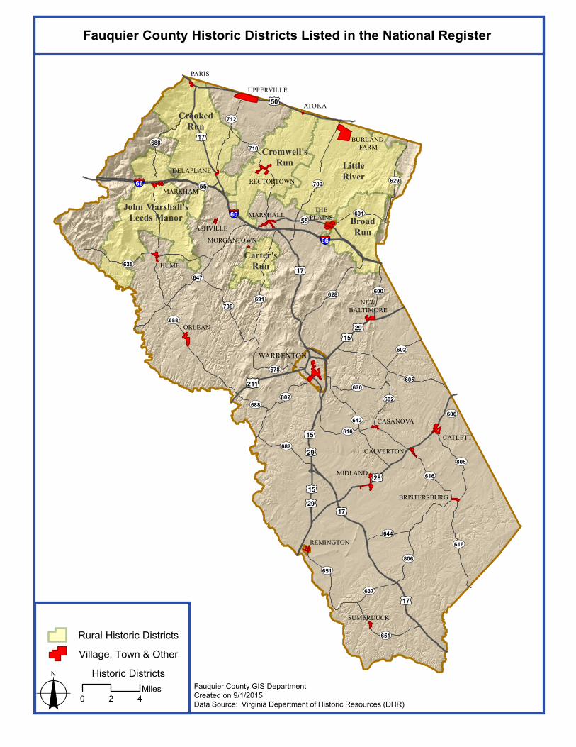
Rural Historic Districts
As defined by the National Park Service, a rural historic landscape is a geographical area that historically has
been used by people, or shaped or modified by human activity, occupancy, or intervention, and that possesses a
significant concentration, linkage, or continuity of areas of land use, vegetation, buildings and structures, roads
and waterways, and natural features. Although each rural landscape has unique characteristics, all types of rural
historic landscapes contain substantial areas of vegetation, open space, and natural features that can embody,
through past use or physical character, significant historical values.1
Rural historic landscapes usually fall within one of the following types based upon historic occupation or land
use:
agriculture (including various types of crop cultivation, grazing, and animal husbandry)
industry (including mining, lumbering, fish-culturing, and milling)
maritime activities, such as fishing, shipbuilding, or recreation (including hunting or fishing camps)
transportation systems
migration trails
conservation (including natural reserves)
sites adapted for ceremonial, religious, or other cultural activities, such as a camp meeting grounds.
Through considerable effort and funding made by private citizens and organizations, six rural historic districts
have been listed in the Virginia Landmarks Register and/or the National Register of Historic Places. Four others
1 To learn more about evaluating rural historic districts, see National Register Bulletin 30, Guidelines for Evaluating & Documenting Rural Historic Landscapes at http://www.nps.gov/history/nr/publications/bulletins/nrb30/.
£¤17
£¤28
£¤17
£¤29
£¤17
£¤29
£¤211
£¤15£¤29
£¤15
£¤50
UV616
UV738
UV651
UV606
UV709
UV637
UV616
UV688
UV644
UV602
UV678
UV628 UV600
UV601
UV687
UV602
UV616
UV712
UV629
UV710
UV691
UV635
UV605
UV651
UV647
UV688
¬«55
¬«55
UV688
UV806
UV802
UV806
UV643
£¤15
UV670
§̈¦66
§̈¦66
§̈¦66
£¤17
ASHVILLE
ATOKA
BRISTERSBURG
CALVERTON
CASANOVA
CATLETT
DELAPLANE
HUME
MARKHAM
MARSHALL
MORGANTOWN
NEWBALTIMORE
ORLEAN
PARIS
RECTORTOWN
REMINGTON
SUMERDUCK
UPPERVILLE
WARRENTON
THEPLAINS
MIDLAND
BURLAND FARM
LittleRiver
BroadRun
Cromwell'sRun
CrookedRun
John Marshall'sLeeds Manor
Carter'sRun
Fauquier County Historic Districts Listed in the National Register
o 0 2 4Miles
Rural Historic Districts
Village, Town & Other Historic Districts
Fauquier County GIS DepartmentCreated on 9/1/2015Data Source: Virginia Department of Historic Resources (DHR)

Appendix II Fauquier County Heritage Resources—An Overview
Page 14
have been determined potentially eligible for listing.2 This is quite unusual for any one locality
Rural Historic Districts Listed in the Virginia Landmarks Register (VLR) &
National Register of Historic Places (NRHP)
4/31/2016
Rural Historic District Year Listed in the VLR Year Listed in the
NRHP
Broad Run / Little Georgetown Rural HD 2009 2016
Carter’s Run Rural HD 2014 2014
Cromwell's Run Rural HD & boundary increase 2008 2008
Crooked Run Valley Rural HD 2004 2004
John Marshall Leeds Manor Rural HD 2007 2007
Little River Rural HD 2013 2014
Battlefields and Other Military Heritage Resources
Fauquier County, positioned between Washington D.C. and Richmond, was a geographical crossroads of the
Civil War. By the summer of 1862, the County was considered an area of strategic importance to both Union
and Confederate commanders. For the South, it provided a gateway to and from the Shenandoah Valley. For
the North, it protected the movement of troops and supplies through Manassas Gap and cushioned the defense of
Washington, D.C. Fauquier County became occupied territory by both armies—control of the Town of
Warrenton changed 67 times throughout the course of the war. Intense battles, piecemeal skirmishes, soldier
encampments, cavalry raids, wholesale destruction of communication and transportation lines, plundering and
burning of civilian property, and the continuous, and largely unwelcome, presence of soldiers were all part of
life during the war. The constant movement and destruction of four years of military action left scars on the
landscape that remain today.
The battlefield landscapes are key to developing a firm comprehension of all aspects of the Civil War in
Fauquier County. Most battlefields are considered significant to understanding our national history. Therefore,
they are very important heritage resources that have been determined eligible for National Register listing.
(Auburn I & II Battlefields and portions of Thoroughfare Gap Battlefield are now listed in the National
Register.) Twelve battlefields have been designated within the County borders. They are identified in the table
below.
Civil War Battlefields Identified in Fauquier County
9/1/2015
Battlefield Date(s) of Battle Extends into Adjacent County? Total Acres
(as est. by ABPP)
Aldie Battlefield June, 17, 1863 X 3,865.83
Auburn I Battlefield Oct. 13, 1863 2,205.26
Auburn II Battlefield Oct. 14, 1863 4,403.24
Brandy Station Battlefield June 9, 1863 X 19,924
Buckland Mills Battlefield Oct. 19,1863 X 10,375.4
Kelly’s Ford Battlefield March 17, 1863 X 3,755.5
Manassas Gap Battlefield July 23, 1863 X 5,225
Middleburg Battlefield June 17-19, 1863 X 4,368.19
Rappahannock Station I Battlefield Aug. 22-25, 1862 X 34,745.39
Rappahannock Station II Battlefield Nov. 7, 1863 X 11,808.74
Thoroughfare Gap Battlefield Aug. 28,1862 X 3,872.19
Upperville Battlefield June 21, 1863 X 14,586
2 Other Fauquier County rural historic districts have been identified and determined eligible for listing by DHR staff but are not officially listed, including: the Springs Valley Rural Historic District, the Elk Run-Germantown-Cedar Run Rural Historic District, the Mt. Holly Ridge-Marsh Run Rural Historic District, and the Hedgeman-Rappahannock Rural Historic District.

£¤17
£¤28
£¤17
£¤29
£¤17
£¤29
£¤211
£¤15£¤29
£¤15
£¤50
UV616
UV738
UV651
UV606
UV709
UV637
UV616
UV688
UV644
UV602
UV678
UV628 UV600
UV601
UV687
UV602
UV616
UV712
UV629
UV710
UV691
UV635
UV605
UV651
UV647
UV688
¬«55
¬«55
UV688
UV806
UV802
UV806
UV643
£¤15
UV670
§̈¦66
§̈¦66
§̈¦66
£¤17
ParisUpperville
RectortownDelaplane
Atoka
MarkhamLinden
Hume
OrleanNew
Baltimore
AshvilleThe
PlainsMarshall
Warrenton
Opal
Bealeton
Remington
Midland
CalvertonCatlett
Bristersburg
Morrisville
GoldveinSumerduck
o 0 2 4Miles
Civil War Battlefields
BattlefieldsAuburn I & IIAldieBrandy StationBuckland MillsKelly's FordManassas GapMiddleburgRappahannock Station I & IIThoroughfare GapUpperville
National Register Listing
Fauquier County GIS DepartmentCreated on 9/1/2015Data Source: National Park Service, American Battlefield Protection Program (ABPP), Virginia Department of Historic Resources (DHR)
Note: Battlefield boundaries were initially determined by the Civil War Sites Advisory Commission (CWSAC) and updated in 2009 by the ABPP using on-site field assessment, additional scholarship, and Global Information System (GIS) technology to represent a deeper understanding of troop approach, withdrawal, and maneuver, as well as engagement for each battle. Battlefield boundaries could be modified in the future as additional site-specific details are discovered through archaeological study.

Appendix II Fauquier County Heritage Resources—An Overview
Page 16
Because of national concern over the increasing threat to the preservation of Civil War sites, the Civil War Sites
Advisory Commission (CWSAC), a group appointed by Congress and the Secretary of the Interior, undertook a
two-year study in 1991 that identified the nation’s significant Civil War sites. The CWSAC studied and
prioritized 383 principal battlefields, including the twelve in Fauquier County. In 1993, the CWSAC produced a
report that outlined the need for action to save the nation’s Civil War battlefields before they were forever lost to
modern land development. The recommendations in the CWSAC’s Report on the Nation’s Civil War
Battlefields has guided decisions about the allocation of limited public and private sector funding for 20 years.
Much has been accomplished. Tens of thousands of battlefield acres were saved. More than 70 local advocacy
groups, like the Mosby Heritage Area Association, stepped forward to champion battlefields across the nation.
Federal and state legislators passed and continue to pass laws that advance battlefield preservation. However, at
the same time, thousands of battlefield acres were destroyed. Explosive growth in the 1990s and early 2000s
replaced battlefield land with residential, commercial, and industrial development.
In the Civil War Battlefield Preservation Act of 2002, Congress directed the Secretary of the Interior, acting
through the American Battlefield Protection Program (ABPP), a division of the National Park Service, to review
the status of the 383 battlefields listed in the CWSAC 1993 report on a state-by-state basis. In 2009, the ABPP
produced a report that presented an analysis of the condition and preservation activities of the 122 Civil War
battlefields in Virginia. ABPP conducted on-site survey and assessment, additional historical research, and an
examination of impending threats to all twelve Fauquier County battlefields. In addition, the ABPP expanded
its assessment to examine whether and to what extent each landscape retained historic integrity. Analysis of
these factors was accomplished with Geographic Information System (GIS) software, an advanced tool used
rarely in the CWSAC study of the early 1990s. Where more recent knowledge of historic terrain dictated, the
ABPP revised battlefield boundaries to reflect a deeper understanding of troop approach, withdrawal, and
maneuver to convey a fuller awareness of the story and physical setting of each battle. (This report can be
obtained through the ABPP website at www.nps.gov/history/hps/abpp/CWSII/CWSIIStateReportVA.htm.) In
2012, a final report was produced for Congress.
Fauquier County Civil War Battlefields – Condition Determined in 2011 by ABPP
Battlefield Condition in
2011
Land Use
Change/Threat
Rating
Preservation
Priority Rating
Aldie 1 2 2
Auburn I 1 2 2
Auburn II 1 2 2
Brandy Station 2 1 1
Buckland Mills 2 1 2
Kelly’s Ford 2 3 3
Manassas Gap 2 2 2
Middleburg 1 2 2
Rappahannock Station I 2 2 2
Rappahannock Station II 2 2 1
Thoroughfare Gap 2 2 1
Upperville 1 2 2
Condition Key: 1 = Landscape is little changed. 2 = Landscape is somewhat altered, but most essential features remain.
3 = Landscape is significantly altered/fragmented, few historic features remain. 4 = Landscape bears little or no resemblance to its Civil
War appearance and character.
Land Use Change/Threat Key: 1 = Rapid & widespread changes. 2 = Steady & accelerating changes. 3 = Slow & accumulative changes.
4 = Only isolated features & protected parcels survive.
Priority Key: 1 = Immediate, variable-scale protection opportunities, critical need for coordinated nationwide action.
2 = Short-range, landscape-scale protection opportunities. 3 = Long-range, landscape-scale protection opportunities.
4 = Limited, variable-scale preservation opportunities. 5 = Negligible, parcel-scale protection opportunities.

Appendix II Fauquier County Heritage Resources—An Overview
Page 17
The report produced by the ABPP determined that all Fauquier County battlefields were in relatively good
condition in 2011—the battlefield landscapes were determined either “little changed” or “somewhat altered.”
Essential battlefield features remained. However, most of the battlefields were found to be encountering steady
but accelerating change. The Buckland Mills Battlefield and Brandy Station Battlefield are now experiencing
rapid and widespread changes; therefore, they are more susceptible to encroaching development. The three
battlefields that were given the highest preservation priority in 2011 included: Brandy Station, Rappahannock
Station II, and Thoroughfare Gap. They warranted immediate coordinated action.
Although much military history has been documented in Fauquier County, many stories remain untold, and they
are still discernable on the landscape. These stories are not only represented in the battlefields, but also in earth
fortifications, solider encampment sites, cemeteries, churches, depots, roads, railroads, hospitals, houses, farms,
mill sites, and military bases, like Vint Hill Farms Station, which was established during WWII. Fauquier
County’s agricultural-based economy and rural landscape have left many sites relatively undisturbed. However,
mounting development pressures and deterioration or loss of historic buildings precipitates the need for Fauquier
County and its citizens to initiate a proactive process to identify, protect, and interpret military heritage
resources. Concentrated planning processes and early recognition of potential sites will help to direct an
effective preservation effort. County land use applications present opportunities, as well as constraints for the
protection of our military heritage sites.
The Mosby Heritage Area
Fauquier County was a part of “Mosby’s Confederacy,” a name given to the territory traversed by Confederate
Colonel John Singleton Mosby from 1863 to 1865. Mosby’s command, the 43rd Battalion, 1st Virginia Cavalry
(also known as Mosby’s Rangers) was a partisan ranger unit noted for lightning fast raids, the ability to elude
Union Army pursuers, and quick withdrawal from pursuit to disappear among the local residents.
The Mosby Heritage Area, named for the activities of John S. Mosby and his ranger unit, is a 1,800 square mile
area in the Northern Piedmont loosely bound by the Bull Run Mountains to the east, the foothills of the Blue
Ridge Mountains to the west, the Potomac River to the north, and the Rappahannock River to the south. The
Mosby Heritage Area encompasses the northern half of Fauquier County. It is a landscape that has retained
many of its original historic landmarks for the past three centuries, including houses, churches, and mill sites, as
well as scenic byways, stone fences, open spaces, agricultural fields, and forest land. The mission of the Mosby
Heritage Area Association (MHAA) is preservation through education and advocacy. MHAA offers a wide
range of programs and services, including school outreach programs, interpretive programs, lectures, and field
trips. The MHAA’s award-winning Conference on the Art of Command in the Civil War is a well-attended
annual event.
Historic Roads
Roads are often overlooked cultural landscapes, but they
are perhaps one of the most important of all human-
made features because they substantially impact historic
events that follow their creation. Along with surveying
and clearing land, the construction of roads was one of
the first enterprises assumed by 18th century Fauquier
County settlers. Most early traces were originally scored
into the earth by wildlife or water. Early settlers slowly
expanded and extended these existing trails to make
travel by foot or horse more manageable. One of the
earliest Colonial Era roads was the Carolina Road (later
named Rogues Road), which roughly followed the route
of the old Shenandoah Hunting Path. Historic
documents indicate that it was utilized by
Alexandria Turnpike, north of Warrenton
The Alexandria Turnpike is shown above with the Warrenton Courthouse in the background (ca. 1862).
Photo courtesy of the Library of Congress

Appendix II Fauquier County Heritage Resources—An Overview
Page 18
European/American travelers as early as the 1720s. Another prominent early road was Dumfries Road, which
began at Quantico Creek, continued to Neavil’s Ordinary at the village of Auburn, where it divided into two
forks before joining again at the town of Salem (now named Marshall), and finally extending to Ashby’s Gap
and beyond through the mountains. Other early roads that crossed the County were born of the need to connect
farms and farmers with Tidewater towns and commercial ports. Some were little more than paths for rolling
hogsheads of tobacco to the riverbanks. Rolling or “rowling” roads are referenced in County land grants as
early as 1724.
Crossroads provided ideal locations for establishments that offered rest and libation for weary travelers.
Taverns, ordinaries, and eventually the creation of villages and towns were established at crossroads. For
example, Fauquier Court House (now the Town of Warrenton) originated around 1759 at the crossroads of the
Falmouth-Winchester Road and the Alexandria-Culpeper Road (later called the Alexandria Turnpike). At that
time, only an ordinary and an establishment called the Red Store existed there.
Virginia Scenic Byways in Fauquier County
The Virginia Scenic Byway Program, which operates in conjunction with the National Scenic Byways Program,
is managed by the Virginia Department of Transportation (VDOT) in partnership with the Department of
Conservation and Recreation (DCR). The Virginia General Assembly established the program and its
requirements in 1966. Pursuant to articles §33.1-62 through §33.1-66 of the Code of Virginia, a Virginia Byway
is designated by the Commonwealth Transportation Board (CTB). To date, twenty-eight (28) scenic byways
have been designated in Fauquier County.
Virginia Scenic Byways Designated in 1983
Route 802 - From Route 229 west of Jefferson in Culpeper County to South Corporate Limits of Warrenton.
Route 245 - From Route 17 south of Old Tavern in Fauquier County to Route 55 at The Plains.
Route T-626 - From Route 55 at The Plains to the North Corporate Limits of The Plains.
Route 626 - From the North Corporate Limits of The Plains to the South Corporate Limits of Middleburg.
Virginia Scenic Byways Designated in 1996
Route 55 – From the Warren County Line at Linden to Route 128 at Thoroughfare Gap
Route F-185 – From Route 713 to Route 721
Route 602 – From Route 670 to Route 616
Route 616 – From Route 602 to Route 28 and from Route 28 to Route 806
Route 628 – From Route 55 to Route 17
Route 635 – From Route 688 to Route 647
Route 647 – From Route 688 to Route 721
Route 651 – From Route 17 to Route 660
Route 660 – From Route 651 to Route 661
Route 661 – From Route 651 to Route 660
Route 667 – From Route 670 to Route 28
Route 670 – From Route 643 to Route 602 and from Route 602 to Route 667
Route 678 – From Route 691 to Route 211 in Warrenton
Route 687 – From Route 651 to Route 802
Route 688 – From Route 17/50 south of Paris to Route 211
Route 691 – From Route 170 to Route 688
Route 702 – From Route 710 to Route 709
Route 709 – From Route 50 at the Loudoun County Line to Route 55
Route 710 – From Route 712 to Route 55
Route 712 – From Route 50 to Route 17
Route 713 – From Route 50 to Route 710
Route 738 – From Route 647 to Route 691
Route 806 - From Route 17 at Morrisville to Route 28
Virginia Scenic Byways Designated in 2001
Route 17 – From its intersection with Route 50 near the Fauquier/Loudoun County Line to its intersection with Route I-66

Appendix II Fauquier County Heritage Resources—An Overview
Page 19
The process for byway designation involves the municipality, local citizens, and the State who cooperatively
determine if a road section, a minimum of 10 miles, warrants designation for its natural, cultural, historical,
recreational and/or archeological significance. To be considered, a segment of road must meet most of the
following criteria: provide important scenic values and experiences, show a diversity of experiences (such as
transition from one landscape scene to another), link together or provide access to scenic, historic, recreational,
cultural, natural, and archaeological elements, bypass major roads or provide opportunities to leave high-speed
routes for variety and leisure motoring, and exhibit zoning or other land-use regulation that reasonably protects
the aesthetic and cultural value of the highway. Scenic byways are roads that generally have lower traffic
volumes and slower travel speeds. Virginia Byway designation does not limit future road improvements, so it
does not necessarily protect historic roadways, but it does draw public attention to a road’s historic significance
and possible heritage tourism and other economic opportunities.
In October 2009, the U.S. Secretary of Transportation designated the 180-mile long route of US Route 15, a
portion of which traverses Fauquier County, US Route 15 Business, and Virginia Routes 20, 231, 22, and 53, as
the Journey Through Hallowed Ground National Scenic Byway. National Scenic Byway is the highest
designation that can be bestowed upon a public road in the United States.
Journey Through Hallowed Ground National Heritage Area
In 2008, the Journey Through Hallowed Ground National Heritage Area (JTHG NHA) was designated as the
38th National Heritage Area in the United States. The entirety of Fauquier County is included as a part of the
JTHG NHA, a four-state partnership that encompasses nine counties and generally follows the alignment of the
Old Carolina Road (Route 15/231) from Gettysburg, Pennsylvania, through Maryland, Harpers Ferry, West
Virginia and finally ending at Thomas Jefferson’s Monticello in Charlottesville. County residents and visitors
can explore this cultural landscape that, according to the late historian C. Vann Woodward, has “soaked up more
of the blood, sweat, and tears of American history than any other part of the country.” The JTHG NHA includes
over 10,000 National Register listed properties, counting nine (9) presidential homes, 30 historic Main Street
communities, thirteen (13) national parks, sites associated with the French and Indian War, Revolutionary War,
and War of 1812, several Civil War battlefields, and hundreds of sites that are relevant to African American and
American Indian history.
National Heritage Areas (NHAs) are designated by Congress. To be considered as a candidate for National
Historic Area status, a landscape must first and foremost have nationally-distinctive cultural, natural, historic,
and scenic resources that, when linked together, tell a unique story about our nation. The NHA program, which
currently includes 49 Heritage Areas, is administered by the National Park Service, but NHAs are not national
park units. National Heritage Areas are public-private partnerships that support historic preservation, natural
resource conservation, recreation, heritage tourism, and public education.
Fauquier County is one of over 150 partner organizations of the Journey Through Hallowed Ground National
Heritage Area, all working collaboratively to provide opportunities for heritage education and recreation that
celebrate the heritage found in this area. The Journey has developed a master corridor management plan,
wayfinding and signage plans, and master landscaping plans. As a partner, Fauquier County is responsible for
encouraging the use of these plans, which can be accessed at http://www.hallowedground.org. As part of the
commemoration of the Civil War Sesquicentennial, the Journey also developed the Living Legacy Memorial
Tree Project, which acknowledged the sacrifice of Civil War soldiers with the objective of planting one tree in
honor of every soldier killed during the war.