Explore, enjoy and protect the planet Building...
32
Explore, enjoy and protect the planet A Guide to America’s Best New Development Projects Better Building
Transcript of Explore, enjoy and protect the planet Building...

Explore, enjoy and protect the planet
A Guide to America’s Best New Development ProjectsBetter
Building

The Sierra Club’s members are 750,000 of your friends and neighbors. Inspired by nature, we work together to protect our communities and the planet. The Sierra Club is America's oldest, largest and most influential grassroots environmentalorganization.
This report was funded by a grant from The Sierra Club Foundation.
85 Second St., Second Floor, San Francisco, CA 94105, (415) 977-5500408 C St. NE, Washington, DC 20002, (202) 547-1141www.sierraclub.org
NOVEMBER 2005 PRINTED ON RECYCLED PAPER
Acknowledgments
This project was made possible through the hard work of many Sierra Club volunteers and staff, including:
The Healthy Communities Campaign (formerly the “Challenge to Sprawl” Campaign)Current and Immediate Emeritus Members: Eric Antebi, Neha Bhatt, Scott Chapman, Tim Frank, MarcHeileson, John Holtzclaw, Ed Hopkins, Cynthia Hoyle (Vice Chair), Ken Hughes, Brett Hulsey, JudyKunofsky, Gregory LeRoy, Aaron Mair, Bill Myers, Mary Ann Nelson, Eric Olson, Angela Silva, PeterTyler (Chair).
Project Coordinator: Eric Olson
Design: Tim Lesle
Research: Eric Olson, Emily Salomon, Jimmy Terpening
Communications: Eric Antebi, Orli Cotel
Field Research and Editorial Assistance:Cheri Briscoe, Scott Chapman, Mark Clemens, Irvin Dawid, Molly Diggins, Patty Durand, Scott Elkins,Natalie Foster, Tim Frank, Susan Gorman, JoAnne Graves, Bryan Hager, Joyce Harms, Marc Heileson,John Holtzclaw, Ed Hopkins, Joshua Houdek, Ken Hughes, Jeremy Marin, Bliss Moore, Mary AnnNelson, Patrisha Piras, Rafael Reyes, Alice Ringer, Stephanie Schaaf, Sue Schwartz, Stephen Scott, AngelaSilva, Marsha Taylor, Christa Wagner, Rosemary Wehnes, Kim Yarbray
Cover photos (clockwise, from top left): Students at the University of Washington, Tacoma, photo cour-tesy of University of Washington, Tacoma; outdoor diners in Windsor, California, photo courtesy of TownGreen Village, LLP; a car in Salt Lake City’s TRAX light rail system, photo courtesy of Marc Heileson;homes in the neighborhood of Southside, photo courtesy of City of Greensboro, North Carolina.
Thank you to all who contributed to this report.
This report has been funded by a grant from The Sierra Club Foundation.
Building Better: A Guide to America’s Best New Development Projects can be found on the Sierra Club’s Website at www.sierraclub.org/sprawl/report05.

INTRODUCTION . . . . . . . . . . . . . . . . . . . . . . . . . . . . . . . . 2
TACOMA, Washington . . . . . . . . . . . . . . . . . . . . . . 4University of Washington, TacomaCharles Moore, LMN Architects
PORTLAND, Oregon . . . . . . . . . . . . . . . . . . . . . . . . . . 6The Pearl DistrictHoyt Street Developers, Gerding/Edlen Development Co.
WINDSOR, California . . . . . . . . . . . . . . . . . . . . . . . . . . 8Town Green Village ProjectOrrin Thiessen and Town Green Enterprises
OAKLAND, California . . . . . . . . . . . . . . . . . . . . . . . . 10Fruitvale Transit Village ProjectThe Unity Council
SAN MATEO, California . . . . . . . . . . . . . . . . . . . . 12Bay MeadowsPeter Calthorpe, Architect
SALT LAKE CITY, Utah . . . . . . . . . . . . . . . . . . . . . . 14Central Business District Extention Project and Gateway AreaSalt Lake City Redevelopment Agency
ALBUQUERQUE, New Mexico . . . . . . . . . . . 16East Downtown Redevelopment ProjectRob Dickson, Paradigm and Co.
HOPKINS, Minnesota . . . . . . . . . . . . . . . . . . . . . . . 18Excelsior Tech Center Redevelopment and Regency ProjectBill Beard, The Beard Group, Inc.
MILWAUKEE, Wisconsin . . . . . . . . . . . . . . . . . . . 20Highland Park: Highland Gardens and Highland HomesHousing Authority, City of Milwaukee
MANCHESTER-BY-THE-SEA,Massachusetts . . . . . . . . . . . . . . . . . . . . . . . . . . . . . . . . . 2210 and 12 Summer StreetManchester Housing Authority
GREENSBORO, North Carolina . . . . . . . . . . 24Southside NeighborhoodRobert "Nate" Bowman, Bowman Development Group
ATLANTA, Georgia . . . . . . . . . . . . . . . . . . . . . . . . . . 26Atlantic StationJacoby Development
Building Better 1
Table of Contents
Albuquerque
Salt Lake City
San MateoOakland
Windsor
Tacoma
Portland
Hopkins
Milwaukee
Manchester-by-the-Sea
Greensboro
Atlanta

Curbing Sprawl, BuildingHealthy Communities
Much of the development in the United Statestoday is sprawling, low density, car-dependent “big-box” or “strip-mall” construction, which producesmore and more traffic and harms our land, air, andwater. The Sierra Club believes there is a better wayto build, and in doing so, to produce healthyneighborhoods, and livable communities.
While the Sierra Club opposes poorly planned,sprawling development, built on natural areas andfarmland, we support quality investment in areasthat already have a history of development toenhance communities and the environment. Byreinvesting in existing neighborhoods and creatingmore walkable, transit accessible places to live andwork, a select subset of the nation’s developmentleaders are raising the bar for neighborhood design.By embracing conservation, green building tech-niques, and affordable housing, and by building onthe assets we already have, these developments offera path to a more sustainable future.
“Good Development”Criteria
We had several criteria for selecting America’s bestnew development projects. Top candidates had to:
• Offer a range of transportation choices, includ-ing walking, biking, and public transportation;
• Redevelop existing areas, rather than developingnatural areas, working farmland, or wetlands;
• Locate homes, retail shops, and offices close toeach other;
• Preserve existing community assets, by re-usingolder buildings and protecting rivers, wood-lands, and farms;
• Minimize stormwater pollution and handle runoffin an environmentally responsible manner; and,
• Be the product of meaningful input by local citi-zens and reflect a broad set of local values.
We also considered the use of “green building”design and housing affordability in compiling ourlist of the best new development.
Building Large and SmallWe arrived at a diverse list of successful projects,
from cities large and small, to suburbs, to smalltowns in each corner of the nation. They involveeconomically challenged areas like Fruitvale inOakland and Highland Park in Milwaukee, as wellas well-off areas like Manchester-by-the-Sea,Massachusetts.
We included massive projects like AtlanticStation in Atlanta, which encompasses 138 acresand includes 12 million square feet of retail, office,residential and hotel, and by contrast, smaller scaleprojects like 66 residential homes and an industrialbuilding in Hopkins, Minnesota.
Building Better 2
Building BetterA Guide to America’s Best New Development Projects
This report highlights America's best new development projects, based on their abilityto offer transportation choices, revitalize neighborhoods, and preserve local values. It alsospotlights some of the movers and shakers—developers, architects, local officials,activists—responsible for making these innovative projects a reality.
ERIC
OLS
ON
A light-rail stop in Tacoma, Washington. Moreon page 4.
The layout of BayMeadows in SanMateo, California. Moreon page 12.
BAY
MEA
DO
WS
LAN
DC
OM
PAN
Y

These model development projects include allmanner of housing: single-family homes, condo-miniums, apartments, and live-work units. Theysupply low and moderate income housing, publichousing, and high-end market rate housing. Retailofferings include large, established departmentstores, restaurants, and shops, as well as local, inde-pendent boutiques and eateries.
With leadership and commitment, as well asneighborhood support, quality redevelopment canbe successful in our towns, cities, and our oldersuburban areas.
The PlayersNone of these innovative projects would have
happened without the vision and determination ofkey individuals and organizations. In some cases, thechampions were developers like Orrin Thiessen inWindsor, California; Rob Dickson in Albuquerque;and Robert “Nate” Bowman in Greensboro, NorthCarolina. Each of these developers decided to buckthe trend of sprawl. In other cases, the champions ofredevelopment were non-profit or public sectoradvocates like the Unity Council in Oakland, theHousing Authority, City of Milwaukee, and the SaltLake City Redevelopment Agency. Yet others whomade these projects happen include the architects,local business leaders, and political leaders. While wehave tried to highlight key individuals or organiza-tions for each case study, in each of these examples,it took a host of people working together to makethe projects succeed.
We hope these projects and their champions willinspire other communities, developers, citizens andpublic officials across the country.
Lessons for the Gulf Coast
Restoring the communities devastated by Hurricane Katrina willrequire the largest rebuilding effort in our nation's history. The win-ning projects in this report hold valuable lessons for the Gulf Coast aswell. New Orleans, where the storm exposed the fact that thousandsof people do not have cars, offers the perfect chance to designneighborhoods to provide many transportation choices. Gooddesign can also make it possible to house people and businesseswithout destroying the wetlands that are vital for flood protection.Probably the most important lesson is that the best new develop-ment projects consistently require strong input from local citizensand are designed to enhance community values, whether thatmeans ensuring affordability or preserving the historic character ofthe neighborhood.
While plans for rebuilding are still unfolding, there is some goodnews. In October, Mississippi Governor Haley Barbour invited over100 of the nation's top architects, designers, and planners—led by“new urbanism” visionary Andres Duany —to brainstorm with localofficials and citizens about options for rebuilding ravaged towns.They offered ideas for downsizing big-box stores, designing walkablecommunities, and developing high quality and affordable housing.Hopefully, their ideas will inspire state and community leaders to notjust rebuild, but to rebuild smarter and better.
Building Better 3
A Mississippi resident stands on the front steps of a house swept away byHurricane Katrina in Biloxi’s D’Iberville neighborhood.
BREW
ERY
BLO
CKS Portland,
Oregon’s PearlDistrict is a for-mer industrialarea that hasbeen redevel-oped into athriving neigh-borhood.
BECKY
GILLETTE

Building Better 4
Area
History and HistoricPreservationThis section of Tacoma, the “Warehouse District,”had been built at the turn of the 20th Century.Located along Commencement Bay of the PugetSound and served by the Northern Pacific Railroad,Tacoma became a thriving commercial center.
Large, sturdy brick warehouses were constructedalong the rail line and close to the Bay. Tacoma’spassenger rail station—an architectural gem—Union Station, was built in 1911 in the same areaas the warehouses, at the terminus of the NorthernPacific Railroad.
By the late 20th century, the area had becomedilapidated and devoid of people or economicactivity. Some proposed leveling the area, but localbusinesspeople and Pierce County’s Director ofEconomic Development in 1986, Ryan Petty,began promoting the idea of a university inTacoma.1 While many in the community thought itwould be too much trouble and expense to reno-
vate, this visionary group—especially the down-town businesses—teamed up with state legislatorsand other leaders to promote the idea of re-usingthe warehouses for a new state university.
In the meantime, Union Station, which had fall-en into disrepair, was purchased by the city for $1,and renovated to become part of the federal court-house. A new state history museum was alsoapproved to be constructed adjacent to the traindepot. As an incentive to the state to locate a cam-pus downtown, the business community put up $1million toward redevelopment at the same timethey started buying options on the warehouse prop-erties to protect them for a campus.
The campus core consists of four renovatedwarehouses and the former Snoqualmie Falls PowerCompany’s transformer house, which has been con-verted into the campus library. The campus planand the renovations of the Power Company houseand warehouses, designed by LMN Architects ofSeattle, and architect Charles Moore, earned awards
University ofWashington,Tacomaof
Downtown Tacoma is booming, in large part due to the University of Washington system investingin this historic area for its new campus rather than choosing a suburban location. In 1997, theUniversity of Washington, Tacoma, opened at 1900 Commerce Street in a former warehouse. Now,
in 2005, the growing campus boasts 2,000 students studying in a part of Tacoma that had only twenty yearsbefore been an empty, blighted, and abandoned former warehouse district.
UN
IVERSITYO
FW
ASH
ING
TON
,TAC
OM
A
TacomaWASHINGTON

Taking A ChanceEstablishing a new campus in downtown
Tacoma was an example of local leaders—primarilybusinesspeople—getting fed up with an eyesore atthe city’s gateway, and taking initiative to create avision, put their own resources into that idea, andthen working relentlessly to sell the idea to stateand local officials and university administrators.
As Bliss Moore, Chair of the Sierra Club’sTacoma area (Tatoosh) Group explains: “The revi-talization of downtown Tacoma over the last 15years shows how a city can turn itself around. Thevisionary leadership from public officials, the busi-ness community and community at-large havemade the proverbial silk purse out of a sow’s ear.The transportation system touts the first modernlight rail system in the region, carrying employers,employees, visitors, and students to the heart ofTacoma from a well-planned major transportationhub on the edge of town just off the I-5 Interstate.This hub accommodatesinterstate, regional, and localtrains and buses with freepublic parking.”5
Public institutions likeuniversities have, in the past,often contributed to sprawl,but increasingly, public enti-ties are beginning to see themultiple benefits of reinvest-ing in existing urban areas.The partnership betweenbusinesses, local and stategovernment, and theUniversity of Washingtonhas created a better Tacoma,reduced crime, increasedeconomic activity, protectedhistorically significant build-ings, and created an areawhere it is easy to walk anduse public transportation.
Building Better 5
from the American Institute of Architects.2
These historic buildings have kept the old tim-bers and brick exposed, while newer buildings arebeing constructed in brick, with attention towardblending in with the historic warehouses thatanchor the campus’ architecture.
Bringing in the Bustle—Good Planning, Walking, andLight Rail
Good planning and design can have a tremen-dous effect on the success or failure of a neighbor-hood. In the case of the University of Washington,Tacoma, the design has contributed toward a thriv-ing area of activity in the streets around campus.There is a seamless transition between campus andthe city, and the university even leases out commer-cial space from the warehouses along PacificAvenue, which faces Union Station, the StateHistory Museum, and the light rail stop.
Locating retail, coffee shops, eateries and theUniversity bookstore in this corridor has livened upthe street considerably with pedestrians. Severalother restaurants and pubs are located on the cam-pus, with one restaurant renovating a historic build-ing on campus on its own.
With the University bringing 2,000 students,plus new faculty and staff to the campus, and up to10,000 students in 10 years, it is adding a large cus-tomer base to Tacoma.3 New condos have beenconstructed in recent years in close proximity to theschool, and several arts and cultural attractions,including Dale Chihuly’s Museum of Glass, haveopened in this district.
The campus and surrounding areas have becomea bustling addition to Tacoma, which only adds tothe demand for retail, hotels, housing, and furtherredevelopment. It is unrecognizable from theempty, crime-filled, and blighted district of twentyyears ago.
In 2003, Sound Transit’s 1.6 mile Light Rail lineopened. It travels in front of the campus, throughthe warehouse district, and connects with SoundTransit’s commuter rail line. Already, it is exceedingthe ridership that was projected in 2010.4
Significant pedestrian improvements were madeduring the process, such as landscaping medians,utility relocation, new sidewalks, benches, trees,lighting, and shelters. This transit connectionmakes the University easily accessible from com-muter rail as well as from other parts of downtownTacoma.
1. Luce, Beth. “Urban Studies,” Columns: The University of Washington Alumni Magazine,December 2004. http://www.washington.edu/alumni/columns/dec04/urbanstudies01.html
2. Ibid.
3. Broberg, Brad. “UW Tacoma Preserves and Transforms a Neighborhood,” Seattle Daily Journalof Commerce, March 8, 1999.
4. Wortman, Marc, PhD, Editor. Public Transportation: On the Move. Visual Reference Publication,Inc., New York, and the American Public Transportation Association, Washington, DC. 2005.p. 146.
5. Moore, Bliss. E-mail to Eric Olson, October 12, 2005.
UN
IVE
RS
ITY
OF
WA
SH
ING
TO
N, T A
CO
MA

Building Better 6
SCO
TTC
HA
PMA
N
Attractive Housing OptionsCurrently there is a mix of more than 1,700
condominiums, townhouses, and apartments builtsince redevelopment efforts began in the area in the1990s and over 1,500 new housing units plannedfor the district in the coming years.2 Importantly,the developments include a mix of incomes, withpublic investment from the Portland DevelopmentCouncil contributing to a stock of affordable hous-ing units. Over six multi-story apartment buildings,with over 800 affordable units, have been con-structed to maintain affordability in the District aswell as to balance out the rapid redevelopmentunderway with a focus on market rate housing.3
For now, the demographics of the Pearl Districtare mostly adults and young couples, however,slowly families are settling into the area, with a few
area schools nearby. There is housing designated forseniors, too, contributing to a more diverse neigh-borhood. For example, REACH CommunityDevelopment, a local affordable housing providerrecently completed building Station Place, a “green”tower of 176 one and two bedroom apartmentunits for 55-plus individuals, all with incomes at or30, 50, or 80 percent below median income.4
Creating a PedestrianEnvironment
The first major redevelopment project withinthe Pearl District began in 1997 when Hoyt StreetProperties bought a former 34-acre rail yard,encompassing 30 blocks.5 Hoyt Street Developerscollaborated with the Portland Development
The Pearl District has historically been an industrial area of Portland, Oregon. Today, through redevel-opment efforts, this district has been converted into a thriving mixed-use neighborhood with a vari-ety of housing units, shops, and businesses. Many of the buildings are renovated warehouses and fac-
tories that long went abandoned until two decades ago. During the 1980s, the Pearl District slowly became apopular destination for artists who were attracted to the abundance of loft space and affordable rent, andproximity to downtown. By the 1990s, private investors were expressing interest in the older warehouses,and soon restaurants and other entertainment venues were moving into the area.
In urban planning circles, Portland has emerged as a model city, at the forefront of creating a vibrant,quality urban environment, and the Pearl District only bolsters its reputation. Jill Fuglister, ExecutiveDirector of the Coalition for a Livable Future describes the area: “The Pearl District is a great example ofhow we can create a marketable, compact, green neighborhood in an already developed area, preservinggreenfields and preventing sprawl in other parts of the metro region. Going forward, we will need to makesure that middle and lower income families will always have a place in the Pearl District.”1
PortlandOREGON
The Pearl District

Brewery Blocks, a recycling program diverted 96percent of construction waste from going to land-fills.6 The latest green energy technology, includingwindows, lighting, insulation, and solar power areprojected to save between 20 and 30 percent ofenergy costs per year. It is projected that after threeyears, the extra expenses to buy the “green” materi-als will be offset by the savings in energy.
Other historic buildings have been rehabilitatedin the Pearl District using green building technolo-gy. The Jean Vollum Natural Capital Center, whichis an office building located in the Pearl District, isa gold-level certified Leadership in Energy andEnvironmental Design (LEED) building.7 Its eco-roof will reduce storm water runoff by filtering andabsorbing rainwater, and also reduce the urban heatisland effect.
Commission to relocate a highway ramp thatwould have divided the neighborhood. Relocationof the ramp also helped to encourage transportationoptions other than cars in the area, making it amore walkable neighborhood. The rail yard hasbeen transformed into a mixed-use neighborhoodwith nine different apartment and condominiumbuildings, some with retail space on the groundlevel.
Multiple transportation options exist for indi-viduals traveling to or within the Pearl District.TriMet, the regional transit authority, offers freefares to ride light rail or bus within a designateddowntown boundary, called “fareless square.” Thisapplies to public transportation within some areasof the Pearl District, since part of it overlaps withthe downtown zone. In addition, the City ofPortland runs a modern streetcar line through thefareless square component of the Pearl District. TheDistrict is also extremely conducive to pedestrians,and free walking maps of the neighborhood areavailable at most shops within the area.
The Pearl District is also home to parks.Jamison Square Park is popular for both residentsand those who live elsewhere. Tanner Springs Parkcelebrated its grand opening in August 2005, andblends the industrial character of the area with nat-ural features. Designed with community input, thepark has a wall made of railroad steel, cobblestonepaths, and will have a stream running through it.Two additional parks are planned for constructionin the Pearl District. Recreational space along theWillamette River is easily accessible from theDistrict as well, with a bridge connecting the PearlDistrict to the other side of the river in the plan-ning phase.
Saving History, Saving EnergyIn 2000, another large-scale redevelopment proj-
ect in the Pearl District began on the site of a for-mer five-block brewery, called the Brewery Blocks.Gerding/Edlen Development Company bought thehistoric brew houses, which are being convertedinto approximately 1.7 million square feet of retailand office space, and new residential buildings thatare under construction nearby. Homeownershipopportunities in the Brewery Blocks range fromapproximately $200,000 to over $1 million. Boththe historic and new buildings are incorporatingenvironmentally friendly techniques that will pro-vide long-term savings as well as conserve energy.For instance, during the construction phase of the
Building Better 7
1. Chapman, Scott. E-mail to Eric Olson, October 6, 2005
2. Portland Tribune’s “Definitive Guide to the Pearl District.” Avaliable online:http://www.portlandtribune.com/pearl/index.html
3. Portland Development Commission Newsroom—7/16/04: “There’s More Affordable Housingin the Pearl than ‘Meets the Eye.’”http://www.pdc.us/pdf/newsroom/story-ideas/affordable-pearl-housing_7-16-04.pdf
4. Portland Development Commission Press Release: “Station Place starts Construction; ProjectBrings Senior Housing, Parking and Retail to River District.”www.pdc.us/new/releases/archive/20030619station.asp?
5. Hoyt Street Properties History. www.hoytstreetproperties.com/pearl_history.html
6. Portland, Oregon’s Office of Sustainable Development.http://www.green-rated.org/cs_detail.asp?id=9&vu=4&md=commercial
7. Cascadia Region Green Building Council, “Jean Vollum Natural Capital Center fact sheet.”https://www.usgbc.org/chapters/cascadia/vollum.pdf
SCO
TTC
HA
PMA
N
Building Better 8
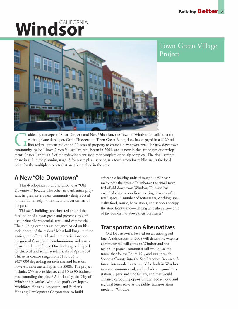
A New “Old Downtown”This development is also referred to as “Old
Downtown” because, like other new urbanism proj-ects, its premise is a new community design basedon traditional neighborhoods and town centers ofthe past.
Thiessen’s buildings are clustered around thefocal point of a town green and present a mix ofuses, primarily residential, retail, and commercial.The building exteriors are designed based on his-toric photos of the region.1 Most buildings are threestories, and offer retail and commercial space onthe ground floors, with condominiums and apart-ments on the top floors. One building is designedfor disabled and senior residents. As of April 2004,Thiessen’s condos range from $190,000 to$439,000 depending on their size and location,however, most are selling in the $300s. The projectincludes 250 new residences and 80 to 90 business-es surrounding the plaza.2 Additionally, the City ofWindsor has worked with non-profit developers,Workforce Housing Associates, and BurbankHousing Development Corporation, to build
affordable housing units throughout Windsor,many near the green.3 To enhance the small-townfeel of old downtown Windsor, Thiessen hasexcluded chain stores from moving into any of theretail space. A number of restaurants, clothing, spe-cialty food, music, book stores, and services occupythe store fronts, and—echoing an earlier era—someof the owners live above their businesses.4
Transportation AlternativesOld Downtown is located on an existing rail
line. A referendum in 2006 will determine whethercommuter rail will come to Windsor and theregion. If passed, commuter rail would use thetracks that follow Route 101, and run throughSonoma County into the San Francisco Bay area. Afuture intermodal center could be built in Windsorto serve commuter rail, and include a regional busstation, a park and ride facility, and that wouldenhance carpooling opportunities. Today, local andregional buses serve as the public transportationmode for Windsor.
Town Green VillageProject
Windsor
Guided by concepts of Smart Growth and New Urbanism, the Town of Windsor, in collaborationwith a private developer, Orrin Thiessen and Town Green Enterprises, has engaged in a $120 mil-lion redevelopment project on 10 acres of property to create a new downtown. The new downtown
community, called “Town Green Village Project,” began in 2001, and is now in the last phases of develop-ment. Phases 1 through 6 of the redevelopment are either complete or nearly complete. The final, seventh,phase in still in the planning stage. A four-acre plaza, serving as a town green for public use, is the focalpoint for the multiple projects that are taking place in the area.
TOW
NG
REENVILLA
GE,LLP
CALIFORNIA

Building Better 9
“I can build on 10 acres what would probablyrequire 50 acres if you developed it using a tradi-tional sprawl model...”
—Orrin Thiessen, developer
Town Leadership andDeveloper Collaboration
Town officials in Windsor have clearly expressedtheir desire to preserve natural areas, which was akey reason they turned toward this project’s SmartGrowth and New Urbanist design concepts.Thiessen specializes in mixed-use projects anddowntown redevelopment. He claims, “I can buildon 10 acres what would probably require 50 acres ifyou developed it using a traditional sprawl modelwith tract homes and shopping centers.”5 This isThiessen’s focus because he notices the populartrend for people who want to live in places thathave real downtowns, not “impersonal subdivi-sions” where “nobody knows their neighbors andyou have to get into your car to do anything atall.”6 This is integral to the Village Green as well asthe Town of Windsor’s overall vision for their com-munity, which contributed partial funding to buildand improve infrastructure and construct the green.Windsor’s ability to fund the improvements wasmade possible using open space monies.7 TheGreen also helps bring the natural and built envi-ronment together. A linear park will serve as abuffer between the freeway and the town, and cre-ate recreational opportunities.
Creating a BetterEnvironment
At the final city council hearing for the seventhphase of the project, the Sierra Club SonomaGroup urged the council to approve the project andcountered claims that the project should be reducedin size. The seventh phase, which is located just offdowntown, will provide local residents with muchneeded retail, and will create a mixed-use feel. Thisis one of the only times the Sierra Club hasendorsed a development project like this in SonomaCounty.8
1. Hagar, Laura, “The There There: How developer Orrin Thiessen is single-handedly remakingNorth Bay downtowns,” North Bay Bohemian, April 21-27, 2004.
2. Rush, Laura Hagar, “The Way We Build Now,” NorthbayBiz.com, March 2004.www.northbaybiz.com/archives/2004-03-coverstory.html
3. Hagar, Laura, “The There There.”
4. Ibid.
5. Ibid.
6. Ibid.
7. Ibid.
8. League of California Cities, “Focus on Housing,” July 6, 2005. http://www.imakenews.com/focusonhousing/e_article000424330.cfm?x=b59Kdjb,b30RF2gf,w
TOW
NG
REENVILLA
GE
,LLP

A Community DemandsBetter
Plans to improve this area initially began in1991, after BART proposed to increase auto capaci-ty to Fruitvale Station by converting the parking lotinto a multiple-level parking structure. Fruitvalecommunity members—led by activists from thenonprofit Unity Council local development corpo-ration—opposed the proposal as it would haveexacerbated traffic and pollution problems in theneighborhood, as well as create a greater barrierbetween residents and the transit station.Recognizing that the local BART station was anasset to revitalize and that there was an opportunityto redevelop the neighborhood and economy, theUnity Council took the lead engaging local resi-dents, businesses, and other stakeholders to worktoward a better plan. The Unity Council is anorganization that for four decades has advocated forthe Fruitvale neighborhood and its largely Latino,
low-income population on economic and environ-mental justice issues. In this case, the UnityCouncil worked with BART and the City ofOakland to facilitate community meetings; thelocal bus system (AC—or Alameda/Contra Costa—Transit) also became a partner in the discussions,since bus is the essential mode of public transporta-tion for many of the local residents. These meetingsled to the creation of a community plan for rede-velopment that addresses the needs and concerns ofthe Fruitvale community in a successful example ofEnvironmental Justice.
Before and AfterIn stark contrast to the acres of parking lot that
existed, the result of the community- based plan-ning process is an award winning, mixed-use, tran-sit-oriented development (TOD). The FruitvaleTransit Village consists of 47 housing units, 40,000
Building Better 10
Located in the Fruitvale neighborhood in Oakland, California, this redevelopment—which opened inMarch 2005—sits on a nine acre parcel that was previously a parking lot serving the Fruitvale BayArea Rapid Transit (BART) station.
BART
OaklandCALIFORNIA
Fruitvale TransitVillage Project

Building Better 11
square feet of retail and restaurant space, plus alibrary, a child care facility, and a health clinic,114,510 square feet of office space, and two park-ing garages.1 An important consideration was givento making the area unique and local, which isreflected in its retail. Only twenty percent ofFruitvale Transit Village’s retail is open to nationalchains, in contrast to so many new developmentsthat offer the same retail fare across the nation.
The 47 housing units help address a shortage ofquality housing in the Fruitvale neighborhood area.Ten of the 47 units are designated affordable, whilethe others are rented at market rate.2 Some are loftunits, however, many have been designed specificallyfor families. The housing is maintained and man-aged by the Unity Council, which has a long historyand strong track record of housing successes.
Innovative Bicycle andPedestrian Leadership
Emphasis on pedestrian activity is central to thevillage, with the community all within walking dis-tance of the BART station. A pedestrian plaza,named Independence Boulevard, runs through theneighborhood, bringing the BART Station andnearby business district together. Restaurants, retailstores, and public art contribute to an attractivestreetscape that lines Independence Boulevard. Thispedestrian plaza also serves as a public space thathosts a market, neighborhood festivals, and othercommunity-wide events. The Fruitvale communityis also served by a dozen AC Transit bus routes, andplans for a Bus Rapid Transit (BRT) service onnearby International Boulevard are underway.
Although there are two parking garages on theoutskirts of the village, the City of Oakland passeda zoning ordinance to ban construction of addition-al automobile parking within the boundaries of theVillage in order to “maintain the pedestrian-orient-ed character of the Transit Village.”3 Over 6,000passengers use the Fruitvale BART stationeveryday,4 and the addition of the Fruitvale BikeStation has encouraged bicycling as an attractiveway for commuters and local residents to travel intoand within the Transit Village. The bike station is afree, indoor bike storage facility for over 230 bikes,which is supervised during commuter hours.Additionally, the bike station, run by an area bikeshop, has on-site retail and repair facilities andstresses local youth employment. The FruitvaleBART station is the second largest bike station inthe nation,5 and the only BART station in the sys-tem that offers such bike services.
As the Oakland City Council President, IgnacioDe La Fuente noted, “The Fruitvale Transit Villagewas designed to be on the cutting edge of smartgrowth projects that get people out of their carsand onto alternative forms of transportation. Withthe completion of the bike station, the last piecewill be in place.”6
A Model for Others to FollowThis redevelopment at Fruitvale demonstrates
the value of community advocacy in local trans-portation and land use planning. Instead of largescale parking garages surrounding the BART sta-tion, the community now enjoys a lively town cen-ter that serves residents and encourages bike, pedes-trian, and public transportation use. It should be amodel for multi-modal development and redevelop-ment around transit in existing neighborhoodsthroughout the nation.
BART
1. Tompkins, Benjamin, “The Promise of a Village: Oakland’s Fruitvale District,” AmericanInstitute of Architects San Francisco.http://linemag.org/_line/article_template1_search.php?a_id=133¤tIssue=22004
2. Ibid.
3. Federal Highway Administration. “Partnerships, Enhancements, and Public Involvement.”http://www.fhwa.dot.gov/environment/ejustice/case/fruitvale.pdf. Page 9.
4. Kassan, Jenny. “Fruitvale Village has been Key to Neighborhood Growth.” Oakland BusinessReview, March 2005. http://www.oaklandchamber.com/obr_stories/2005_03_fruitvale_village.shtml
5. “Bikes on BART,” Bay Area Rapid Transit Web site.http://www.bart.gov/guide/bikes/bikeOverview.asp
6. “Fruitvale Bike Station Ready for Commuters,” Oakland Chamber of Commerce Web site.http://www.oaklandchamber.com/obr_stories/2004_12_ed_fruitvale_bart.shtml

Bay Meadows IThe first phase of construction—built on a
practice horseracing track adjacent to the actualracetrack which is slated for redevelopment as partof Phase II—is a thriving residential, office, andretail community.
This mixed-use redevelopment includes 734housing units: 579 condominiums, 98 townhomes,28 single-family homes, and 27 small lot single-family homes. Ten percent of the housing is moder-ately priced. The retail component is 98,000 squarefeet and includes a Whole Foods grocery store, tworestaurants, several other eateries and coffee shops,a health club, and small stores. The nearly 750,000square feet of office space is almost all the head-quarters of Franklin Templeton, a mutual fundcompany that employs 1,247 people at this loca-tion.1 There is still room for the office component
to expand by another 340,000 square feet, and a siteoriginally designated for a hotel is likely to insteadbecome a multifamily housing use. The last remain-ing space in Bay Meadows I, which was slated for arestaurant, is expected instead to become a publicuse as the site of the City’s new police station.
Commuter RailAll of Bay Meadows I is approximately within a
half mile walking distance of the Hillsdale com-muter rail station, although due to the configura-tion of the site, some of the areas are a longer walk,15 to 20 minutes, rather than the typical 8 to 10minutes to walk to the station. While the develop-ment is close to rail, there is recognition that walk-ing routes to the station could have been donemore conveniently. There is hope that even betterwalking and bike paths will be incorporated into
Building Better 12
Bay Meadows
San Mateo
Bay Meadows is an ambitious two-part development that contains housing, office, and retail in SanMateo, California—a city of 96,000 between San Jose and San Francisco. The plan for Phase I wasadopted in 1997, and the project was built several years later. Now, in 2005, the second phase is
going through the local planning process. These sites are convenient to rail and reflect “New Urbanist”design in a region that is experiencing significant growth.
BAY
MEA
DO
WS
LAN
DC
OM
PAN
Y
CALIFORNIA

the development in the future.The Caltrain “Baby Bullet” commuter rail line,
which runs between San Jose and San Francisco,stops at both the Hillsdale station and the HaywardPark station. The proposed Bay Meadows II will belocated within the 600 acres that lies between thetwo stations. In fact, the Hillsdale station will berelocated, which will serve the redevelopment evenbetter, and will help improve rail service by addingsidetracks to help express trains bypass slowertrains. The “Baby Bullet” service began its com-mute hour express service in 2004, and nowincludes 11 morning and 11 evening weekday trips.The trains travel up to 79 miles per hour, and makethe trip between San Jose and San Francisco in lessthan an hour.
This train service makes housing at BayMeadows extremely popular, as residents can com-mute easily and efficiently to either major city—indeed it is an ideal commute for couples who eachwork in one of the cities. Stephanie Schaaf andRafael Reyes are one such San Mateo couple.Stephanie explains their situation: “With the BabyBullet train service, San Mateo is convenient for us.In the morning, I head off to San Jose, while Rafaelcommutes to San Francisco. We can only imaginethat couples like us will find Bay Meadows II, withits proposed stores, and its short walk to the train,to be an ideal place to live in the future.”2
Bay Meadows IIIn order to meet the Transportation Demand
Management requirements, this project depends uponcommuter rail. If this proposed development wereauto oriented rather than transit oriented, it would failto meet the planning and zoning regulations.
Bay Meadows II will be built upon 83 acres that iscurrently a horseracing track. This site is next to BayMeadows I, and located between the Hillsdale andHayward Park commuter rail stations.
There will be between 1,000 and 1,500 housingunits, including a mix of condominiums, townhomesand single family. Ten percent of these housing unitswill be affordable, moderately priced dwelling units.
Like Phase I, this project will be a “New Urbanist”design with a mix of uses and an emphasis on creatinga sense of place and community, rather than a genericdevelopment. The walkability of Bay Meadows II tothe train station is exceptional, with eighty percent ofthe site within a quarter mile of the station, and all ofit within a half mile.
The office portion of the project will include
between a million and 1.5 million square feet, whileretail at the site is slated at 150,000 square feet. Thisretail space will be located on a three-block MainStreet area, with traditional design of stores at ground-level and housing above. The plan also includes signif-icant green space with 15 acres of parkland.
As of this report’s press time, Bay Meadows II hasnot yet been formally approved, but it is anticipated.Some of the details that—from an environmental,smart growth perspective—are important for localofficials to approve include: building the full 1,500housing units, ensuring that the parkland will remainat 15 acres, creating more and better pedestrian andbicycle connections (especially those linking Phase Iand Phase II of the development), and incorporatingmore sustainable development methods and efforts toprotect water quality.
Forward-looking Design andPlanning by Peter Calthorpe
Bay Meadows I and II reflect the design of PeterCalthorpe, one of the nation’s leading NewUrbanist architects. Calthorpe is a founder and thefirst Board President of the Congress for NewUrbanism, which promotes walkability, mixed uses,and traditional neighborhood design for new devel-opment projects. Calthorpe has written and lec-tured extensively on the subject of urban design,and creating more sustainable communities.
Peter Calthorpe has led the way to better com-munity design among architects in the last quartercentury, and is leading the way on the BayMeadows project.
Building Better 13
1. E-mail communication with Cindy Ailey, Public Relations, Franklin Templeton Investments,September 26, 2005.
2. Schaff, Stephanie, e-mail to Eric Olson, October 3, 2005.
BAY
MEA
DO
WS
LAN
DC
OM
PAN
Y

Visionary LeadershipWithin the last decade, Salt Lake City has
become a leader at creating a vibrant, transit-orient-ed, livable city. The City opened TRAX, its lightrail system, in December 1999, and ridership sur-passed all expectations. The Federal TransitAdministration estimated that ridership would be14,000 per day in 2020, but in 1999, there werealready 20,000 daily riders on the North-Southlight rail line.1 TRAX has been so popular that in2000, voters approved a tax increase to extend lightrail. The City’s leadership, non-profit community,business leaders, and environmentalists have pro-moted redevelopment within Salt Lake City, and astrong public transportation network in order tocreate a more thriving city.
Several players at the local and state level havemade this transformation possible. Envision Utah isa group of business and political leaders, formed inlarge part by Bob Grow, a local businessman, in1998. Envision Utah promoted a transparent plan-ning process for the greater Salt Lake City area thatlooked at different patterns of urban growth, and
brought key leaders into the process. Ultimately,the plans that received the most consensus were: 1)those that promoted light rail and commuter railover roads; 2) those that concentrated developmentaround transit; and 3) those that would redevelopexisting urban areas. This process helped establish ablueprint for how the region could best chart acourse for the future.
Mayor Rocky Anderson and the Salt Lake CityRedevelopment Agency also provided strong leader-ship and helped focus efforts on revitalizing andcontributing toward Salt Lake City’s renaissance.The Church of Latter Day Saints is also investingin the city’s downtown to the tune of at least $500million to redevelop a blighted mall in the CentralBusiness District.
Central Business District: AnImproved Downtown
Many players, including the Salt Lake CityRedevelopment Agency, sought an expansion of theCentral Business District (CBD). This area, consid-
Building Better 14
Central Business DistrictExtension Project andGateway Area
Salt Lake City
Salt Lake City has enjoyed—and continues to enjoy—significant revitalization. Part of the City’s rede-velopment efforts were sparked by the anticipation of the 2002 Winter Olympics, but now, three yearslater, Salt Lake City continues on a path of smarter growth.
Two areas that have undergone a transformation, and continue to redevelop, are the Central BusinessDistrict—which is getting extended—and the Gateway area.
MA
RCH
EILESON
UTAH

ered the “downtown” of Salt Lake City, is home tomany of the arts and cultural centers of the region,it is where many office buildings are located, and itis home to the convention center and hotels. TheCentral Business District is also an area that ishome to the Church of Latter Day Saints, and thedowntown also has retail and department stores.
Traditionally, however, the CBD has not includ-ed housing. To remedy this, the RedevelopmentAgency, among others, has been working to addhousing to the downtown mix. These efforts areleading to new housing construction as well as ware-house conversions downtown, and it is helping cre-ate a more lively area in Salt Lake City. Addinghousing in the CBD means that residents can live,work, and play all within a short radius that is easilyaccessible by walking or light rail. In this decade,over 2,000 new housing units are expected to beadded to downtown—that’s on top of 960 unitsthat were added in the 1990s.2 Over 10,000 resi-dents will be living in the Central Business Districtby 2010.3 The Redevelopment Agency of Salt LakeCity has been focusing low-interest loans on theCBD for housing, and has a specific program forconverting warehouses to housing. The arrival ofhousing in the CBD creates more business for localrestaurants and retailers, and reduces the need ofresidents to drive, lessening traffic and air pollution.
Gateway Area: FromWarehouses to Urban, TransitCommunity
A few blocks from the Central Business Districtis the 650 acre Gateway Project Area. The GatewayArea is becoming a dense, transit-oriented commu-nity, anchored by the new Multimodal Hub. Thistransit station is on the south side of the Gatewaydistrict. Today it serves as a station for buses andAmtrak trains, but it will soon also be a station onthe TRAX light rail system, as well as for the newcommuter rail line, which broke ground in August2005. The Multimodal Hub was once the site ofthe “Am-shack”—a storage facility for Amtraktrains, but now the new facility has many trans-portation functions, connecting commuters to bus,light rail, inter-city rail, and commuter rail.
For generations, the Gateway area, which is adja-cent to Salt Lake City’s downtown, was a railyard,warehouse, and industrial area. In recent years, how-ever, the area has been in significant decline. Thearea was considered a “brownfield” site, with con-
taminants from oil, gas, and creosote, and includingpollutants like barium, lead, chromium, seleniumand arsenic. The Salt Lake City RedevelopmentAgency worked with the federal EnvironmentalProtection Agency and developers to alleviate thesecontaminants and redevelop the site.
After receiving federal Economic DevelopmentAdministration grants, and federal Housing andUrban Development grants, the localRedevelopment Agency was able to help assembleproperties for redevelopment.
Today, the redevelopment includes a refurbished,historic Union Pacific Train Depot, which includesretail; a public plaza celebrating the 2002 Olympics;restaurants, culture and entertainment venues—including an IMAX theater and a 12-screen moviemultiplex—and a significant mix of uses. There are650,000 square feet of office and 650,000 squarefeet of retail space in the Gateway development. Itincludes 350 apartments and 150 condominiums.Among these residential units, 135 are affordablehousing. Other investments in the district includenew curbs, gutters, and sidewalks and improvementsto create an attractive streetscape.
During the course of the project, concerns wereraised about the project potentially drawing depart-ment stores away from Main Street. In response tothese concerns, several disincentives were built intothe leasing of the Gateway’s retail space to discour-age leasing to Main Street stores.
A BrightFuture
Salt Lake City hasestablished priorities andinvested in initiatives tocreate a strong, transit-oriented urban core anda healthy mix of offices,retail, and housing. TheCity has shown real lead-ership by making SaltLake City a livable place.
Building Better 15M
ARC
HEILESO
N
1. Anderson, Mayor Ross C., “Address to the Salt Lake City Council,” August 3, 2000.http://www.slcgov.com/mayor/speeches/slcfuture080300.htm
2. “Strictly Business,” Salt Lake City Department of Economic Development.http://www.slcgov.com/mayor/ED/news/Newsletter.pdf
3. Ibid.
Transit-orientedThe Alvarado Transportation Center is a hub of
transit activity with the “Rail Runner”—NewMexico’s new commuter rail line—opening in thefall of 2005, and Albuquerque’s planned new lightrail system on its way. The light rail will intersectwith the Rail Runner Commuter Rail at AlvaradoCenter, where a new Amtrak station andGreyhound bus depot are being built. AlvaradoCenter is the hub for ABQRide, Albuquerque’s bussystem. Service along Central Avenue, throughEDO, includes “Rapid Ride” buses, articulated anddiesel-electric hybrid powered, that are equippedwith red-light signal changing equipment to givepriority and shorten bus rides by 25 percent.
Urban Redevelopment There is significant underused urban space
throughout the Broadway and Central corridor,making it ideal for redevelopment. For years, theseempty streets have seen only limited economicactivity, and there have been very few housingopportunities. Now, with infill developmentincluding housing, retail and other economic uses,the area is coming alive. Its proximity to downtownAlbuquerque creates a strong pedestrian environ-ment. In addition to more expensive loft housing,there will be mixed-income and affordable housing.More new retail and office space will soon be avail-able as well.
Building Better 16
East Downtown(EDO)RedevelopmentProject
Albuquerque
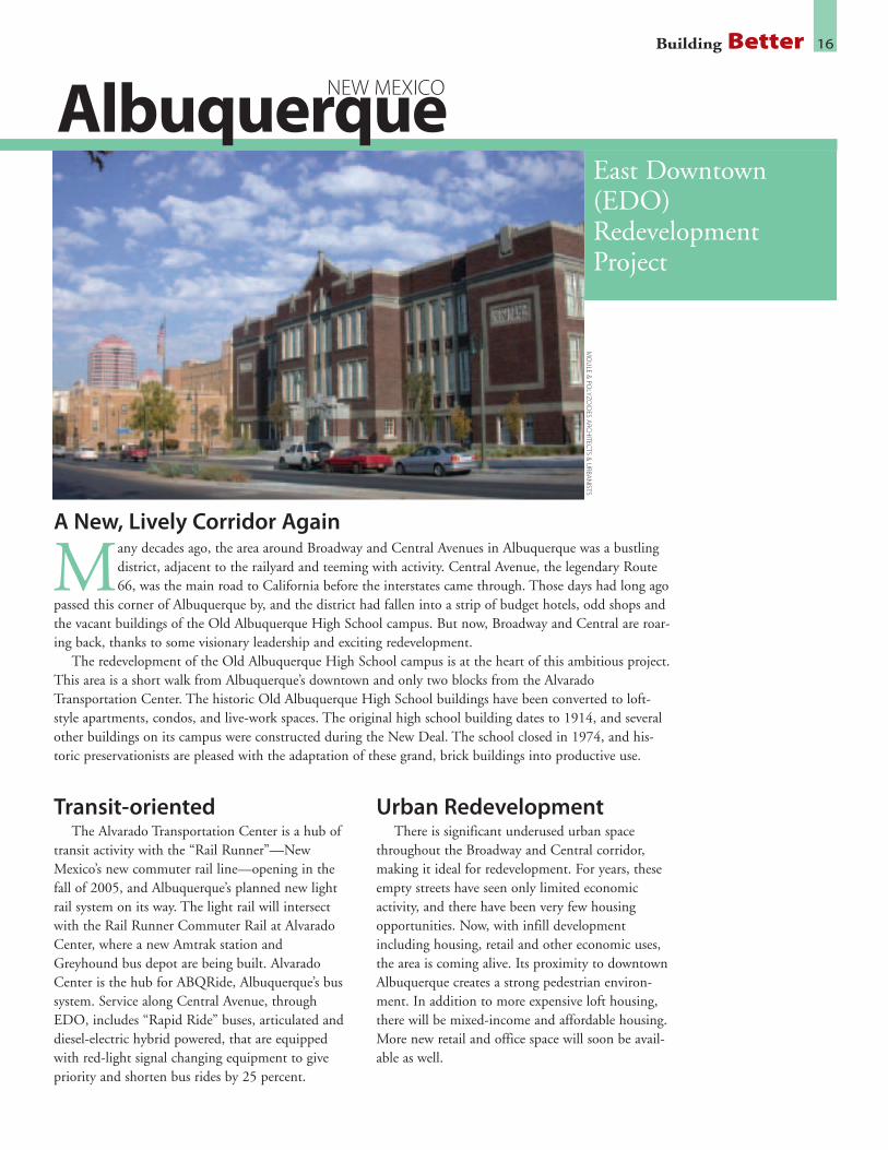
A New, Lively Corridor Again
Many decades ago, the area around Broadway and Central Avenues in Albuquerque was a bustlingdistrict, adjacent to the railyard and teeming with activity. Central Avenue, the legendary Route66, was the main road to California before the interstates came through. Those days had long ago
passed this corner of Albuquerque by, and the district had fallen into a strip of budget hotels, odd shops andthe vacant buildings of the Old Albuquerque High School campus. But now, Broadway and Central are roar-ing back, thanks to some visionary leadership and exciting redevelopment.
The redevelopment of the Old Albuquerque High School campus is at the heart of this ambitious project.This area is a short walk from Albuquerque’s downtown and only two blocks from the AlvaradoTransportation Center. The historic Old Albuquerque High School buildings have been converted to loft-style apartments, condos, and live-work spaces. The original high school building dates to 1914, and severalother buildings on its campus were constructed during the New Deal. The school closed in 1974, and his-toric preservationists are pleased with the adaptation of these grand, brick buildings into productive use.
MO
ULE
&PO
LYZOID
ESA
RCH
ITECTS
&U
RBAN
ISTS
NEW MEXICO

Vision and CommunityInvolvement
In September 2003, Albuquerque put together afive-day planning process for community membersand other stakeholders to weigh in with their ideasfor the future of the East Downtown area. Severalof these meetings were attended by more than 100to 150 citizens. This process resulted in a commonvision for the district, which the Broadway andCentral Corridors Association then incorporatedinto a Master Plan for the area. This was used todevelop an Urban Conservation Overlay Zone forthe area to enable developers to plan new develop-ment that would be what the city and communitydesired. Part of the strength in redeveloping theEast Downtown area has been the involvement andshared vision of stakeholders, making the EDOproject as much a product of the community asthat of developers.
City Councilor, Eric Griego, discussed the planfor East Downtown: “I think the master plan willpromote a dynamic corridor and really encourageredevelopment citywide. I think we will hear frompeople saying this area is really friendly to pedestri-ans and local transit ... it’s going to bring peopleback to live in the heart of the city.”1
Historic PreservationThe East Downtown area is surrounded by the
Huning-Highland historic district. Its redevelop-ment is occurring with a strong effort toward pre-serving and reusing buildings in a way thatenhances the streetscape and creates a welcomingpedestrian environment. Coupled with the conver-sion of the Old Albuquerque High School intohousing as described above, the overall EDO proj-ect is a model of historic preservation and revital-ization efforts coinciding to make an economicallystronger, better, and more vibrant neighborhood.
Making it HappenThese transformations would not have taken
place, however, without the support and vision ofthe Albuquerque City leadership, citizens, businessleaders, and developers. Rob Dickson is the ownerof Paradigm & Co., the Albuquerque redevelop-ment firm that is responsible for the conversion ofthe Old Albuquerque High School. Dickson saw thefuture in the high school campus and stuck with itfor many years. He is in large part responsible for
bringing together the public planning process andhelping rezone the entire area, rather than pursuingredevelopment on a piecemeal basis. Other leadersin the effort to create a vision for the area includedTerry Keane, owner of Artichoke Café, and NewUrbanist architect, Stefanos Polyzoides, who led thedesign team for the EDO redevelopment.
These leaders chose to make the right decisionsby reinvesting in existing communities, where build-ings, infrastructure and transportation choices arealready present. Many developers and other localgovernments choose to instead make the long-termmistake of growing ever farther outward, increasingtraffic congestion, the need for new roads, and theconsumption of land. Developer Dickson, architectPolyzoides, business owner Keane, and the City ofAlbuquerque are helping to create a better, more liv-able community through their efforts on the EastDowntown project; it is clear that the neighborhoodwill thrive well into the future.
Building Better 17M
OU
LE&
POLYZO
IDES
ARC
HITEC
TS&
URBA
NISTS
1. McGivern, Tim. “EDO Master Plan Moves Toward Final Passage,” Weekly Alibi,January 20-25, 2005. http://www.alibi.com/editorial/section_display.php?di=2005-01-20&scn=news&scn_page_num=0#10821
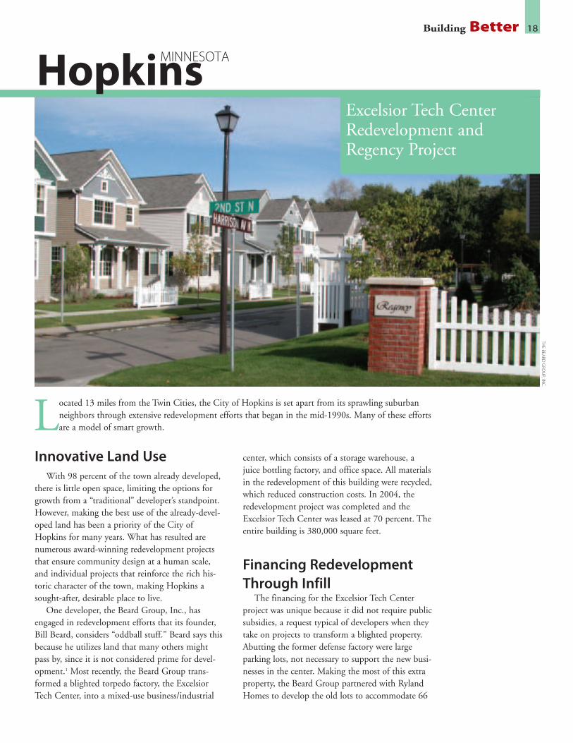
Innovative Land UseWith 98 percent of the town already developed,
there is little open space, limiting the options forgrowth from a “traditional” developer’s standpoint.However, making the best use of the already-devel-oped land has been a priority of the City ofHopkins for many years. What has resulted arenumerous award-winning redevelopment projectsthat ensure community design at a human scale,and individual projects that reinforce the rich his-toric character of the town, making Hopkins asought-after, desirable place to live.
One developer, the Beard Group, Inc., hasengaged in redevelopment efforts that its founder,Bill Beard, considers “oddball stuff.” Beard says thisbecause he utilizes land that many others mightpass by, since it is not considered prime for devel-opment.1 Most recently, the Beard Group trans-formed a blighted torpedo factory, the ExcelsiorTech Center, into a mixed-use business/industrial
center, which consists of a storage warehouse, ajuice bottling factory, and office space. All materialsin the redevelopment of this building were recycled,which reduced construction costs. In 2004, theredevelopment project was completed and theExcelsior Tech Center was leased at 70 percent. Theentire building is 380,000 square feet.
Financing RedevelopmentThrough Infill
The financing for the Excelsior Tech Centerproject was unique because it did not require publicsubsidies, a request typical of developers when theytake on projects to transform a blighted property.Abutting the former defense factory were largeparking lots, not necessary to support the new busi-nesses in the center. Making the most of this extraproperty, the Beard Group partnered with RylandHomes to develop the old lots to accommodate 66
Building Better 18
Excelsior Tech CenterRedevelopment andRegency Project
Hopkins
Located 13 miles from the Twin Cities, the City of Hopkins is set apart from its sprawling suburbanneighbors through extensive redevelopment efforts that began in the mid-1990s. Many of these effortsare a model of smart growth.
THE
BEARD
GRO
UP,IN
C.
MINNESOTA

new homes. The revenues from these townhouses,which were built in the first phase of the project,were then used to finance the renovations of thetorpedo factory. The only public funding was usedto clean up asbestos floor tiles.
Creating a BetterEnvironment and a ShortCommute
The new town homes were an immediate suc-cess, and each unit sold out quickly. The homeswere built based on the existing street grid, whichhelped create a neighborhood of single-familyhomes and row houses. Local rain gardens in theneighborhood help manage storm water on the site.
Unlike typical subdivisions, the neighborhood,called Regency, is adjacent to the Excelsior TechCenter, and is connected by a well-landscaped streetwith adequate sidewalks for pedestrians. Many ofthe offices in the Excelsior Tech Center are staffedby residents of Regency, making for a short com-mute and reducing the need for a car. With theinfill housing occupying the former parking lot,this redevelopment has taken advantage of a greatlocation and created a community of housing andjobs. Additionally, a trail connects the Regencyneighborhood to an extensive trail system throughHopkins, which continues throughout the region,the county, and into Minneapolis. It is importantto note, however, that the homes sold at an averageof $320,000, so while the homes may be withinreach for the tech sector workers, this is not consid-
ered affordable housing.The Hopkins redevelopment is a model for cre-
ating new, vibrant neighborhoods from industrialareas of bygone days. The City of Hopkins’ Mayor,Eugene Maxwell, aptly observes, “When a develop-er and the community come together, the smartgrowth and environmental rewards are enormous.”2
Building Better 19TH
EBEA
RDG
ROU
P,INC
.
1. Werner, Larry. “From Torpedoes to Fruit Juice: Redevelopment Booms in Hopkins.” StarTribune. 12 May 2003.
2. Maxwell, Hon. Eugene, e-mail to Joshua Houdek, October 20, 2005.
“When a developer and the community come togeth-er, the smart growth and environmental rewards areenormous.”
—Hopkins Mayor Eugene Maxwell
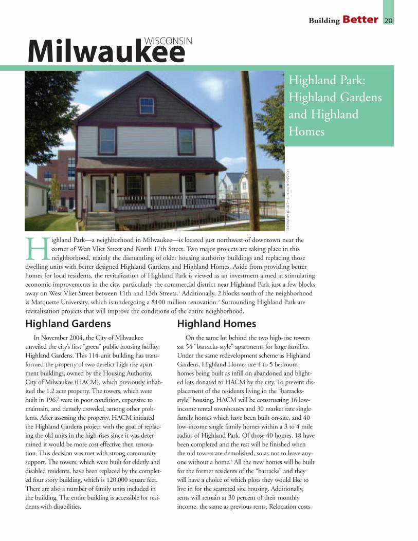
Highland GardensIn November 2004, the City of Milwaukee
unveiled the city’s first “green” public housing facility,Highland Gardens. This 114-unit building has trans-formed the property of two derelict high-rise apart-ment buildings, owned by the Housing Authority,City of Milwaukee (HACM), which previously inhab-ited the 1.2 acre property. The towers, which werebuilt in 1967 were in poor condition, expensive tomaintain, and densely crowded, among other prob-lems. After assessing the property, HACM initiatedthe Highland Gardens project with the goal of replac-ing the old units in the high-rises since it was deter-mined it would be more cost effective then renova-tion. This decision was met with strong communitysupport. The towers, which were built for elderly anddisabled residents, have been replaced by the complet-ed four story building, which is 120,000 square feet.There are also a number of family units included inthe building. The entire building is accessible for resi-dents with disabilities.
Highland HomesOn the same lot behind the two high-rise towers
sat 54 “barracks-style” apartments for large families.Under the same redevelopment scheme as HighlandGardens, Highland Homes are 4 to 5 bedroomhomes being built as infill on abandoned and blight-ed lots donated to HACM by the city. To prevent dis-placement of the residents living in the “barracks-style” housing, HACM will be constructing 16 low-income rental townhouses and 30 market rate singlefamily homes which have been built on-site, and 40low-income single family homes within a 3 to 4 mileradius of Highland Park. Of those 40 homes, 18 havebeen completed and the rest will be finished whenthe old towers are demolished, so as not to leave any-one without a home.3 All the new homes will be builtfor the former residents of the “barracks” and theywill have a choice of which plots they would like tolive in for the scattered site housing. Additionally,rents will remain at 30 percent of their monthlyincome, the same as previous rents. Relocation costs
Building Better 20
Highland Park:Highland Gardensand HighlandHomes
Milwaukee
Highland Park—a neighborhood in Milwaukee—is located just northwest of downtown near thecorner of West Vliet Street and North 17th Street. Two major projects are taking place in thisneighborhood, mainly the dismantling of older housing authority buildings and replacing those
dwelling units with better designed Highland Gardens and Highland Homes. Aside from providing betterhomes for local residents, the revitalization of Highland Park is viewed as an investment aimed at stimulatingeconomic improvements in the city, particularly the commercial district near Highland Park just a few blocksaway on West Vliet Street between 11th and 13th Streets.1 Additionally, 2 blocks south of the neighborhoodis Marquette University, which is undergoing a $100 million renovation.2 Surrounding Highland Park arerevitalization projects that will improve the conditions of the entire neighborhood.
HO
USIN
GA
UTH
ORITY—
CITY
OF
MILW
AU
KEE
WISCONSIN
are covered by the federal Department of Housingand Urban Development (HUD).
Environmental JusticeHighland Gardens and Highland Homes are
replacing what has been described as a “Superblock”because of its isolation from the rest of the commu-nity. Rather than having all dwelling units concen-trated within a “superblock,” a popular model dur-ing Urban Renewal development of four decadesago, one of the overall goals of Highland Park is tocreate a residential neighborhood by creating streetsto reconnect the neighborhood to the city’s grid sys-tem. This helps develop more community interac-tion, plus it provides more travel options and pro-vides better pedestrian access. Previously there wereonly two entrance points into the development fromthe rest of the city,4 exacerbating social and econom-ic isolation of residents. The new streets serve asconnecting points to downtown and a nearby shop-ping district. Alderman Willie Hines, chairman ofHACM, says the new street plan “will do wondersfor the neighborhood. It’s a tremendous develop-ment opportunity that will integrate public housinginto the surrounding community. Before it was anisland unto itself.”5 This development provides amix of public housing—rental and homeownershipopportunities throughout Highland Park.
Incorporating EnvironmentalDesign and Materials
Highland Gardens is one of the first efforts in anenvironmental initiative the City of Milwaukee istaking to make it a “greener, cleaner” place to live.6
The windows, cement, wooden gym floors, andother materials from the two high rises were recy-cled and used in the construction of HighlandGardens. The most prominent environmental fea-ture of Highland Gardens is the 20,032 square foot,modular green roof, “believed to be the largest vege-tated roof on any residential development in thenation.”7 Green roofs are composed of tiles/modulesthat have plants growing in them to absorb andeliminate the storm water runoff that would other-wise overload the storm and sanitary sewers thateventually drain into Lake Michigan.8 Other bene-fits include lower energy consumption since the roofprovides strong insulation for the building, and alonger roof life. The green roof is also designed toreduce the amount of heat given off, which helpsmitigate poor air quality in the summer months.Two rain gardens that landscape Highland Gardens
will also help to deter water runoff. Highland Homes have also been designed to be
more environmental, with energy efficiency animportant component of their construction. Some ofthe features in Highland Homes include energy effi-cient heating, ventilation and cooling, and windows;soy-based insulation, rain gardens, and rain water thatempties to grade rather than into the storm sewer.9
Good Planning and DesignHACM is implementing good design practices in
the remodeling of the Highland Park neighborhood toimprove quality of life by strengthening access to otherparts of the city. Local residents were encouraged toparticipate in planning for Highland Homes andHighland Gardens at a series of public meetings.Many ideas from these meetings were incorporatedinto neighborhood design.10 Using New Urbanismprinciples, Highland Park has been designed to blendin with the surrounding neighborhoods.11 Entrancesenter to sidewalks rather then to parking areas, andthe neighborhood is developing with HighlandGardens serving as a recognizable center.12
Additionally, a local bus hub abuts Highland Park at17th Street with four major bus lines serving the area.
Developing a neighborhood in this fashion con-tributes toward making the community a better,more attractive place to live, makes public trans-portation an efficient option, and reduces the pres-sure on sprawling outside the city.
Building Better 21
1. Bergstrom, Kathy. “Undoing ‘Urban Renewal’ at Highland Park,” The Business Journal ofMilwaukee, June 27, 2003.http://milwaukee.bizjournals.com/milwaukee/stories/2003/06/30/story6.html
2. Housing Authority of the City of Milwaukee, “Rebuilding Hope, Renewing Dreams: HighlandPark HOPE VI.” Grant Proposal to the U.S. Department of Housing & Urban Development,2003. Page 104.
3. Kenneth Barbeau e-mail August 12, 2005.
4. Housing Authority of the City of Milwaukee, “Rebuilding Hope, Renewing Dreams: HighlandPark HOPE VI” Grant Proposal to the U.S. Department of Housing & Urban Development,2003. Page 34.
5. Thomas-Lynn, Felicia. “HUD Money to Spruce Up Highland Park Development.” JournalSentinel, March 11 2003.
6. Tom Barrett, Mayor of Milwaukee, Press Release: “Mayor Barrett Launches Milwaukee GreenTeam to Build a “Greener, Cleaner Milwaukee”, February 22, 2005.
7. Green Grid Fact Sheet: Milwaukee Housing Authority- Highland Gardens.www.greengridroofs.com.
8. Ibid.
9. Kenneth Barbeau e-mail to Emily Salomon, August 18, 2005.
10. Housing Authority of the City of Milwaukee, “Rebuilding Hope, Renewing Dreams: HighlandPark HOPE VI” Grant Proposal to the U.S. Department of Housing & Urban Development,2003. Page 108.
11. Ibid. Page 109.
12. Kenneth Barbeau e-mail August 12, 2005.

Affordable Housing, IdealLocation
The two-phase project began with a $2 millionrenovation of a rundown 21 unit apartment build-ing at 12 Summer Street. Eighteen, or 80 percentof those apartments, have been set aside as long-term affordable rental units. The cost for theseunits is roughly $962/month for two bedrooms,while the remaining apartments are rented at themarket rate of $1375/month.1 This is significantlyless than a private one or two bedroom apartmentin the area which rents for $1,500-2,000 permonth, not including heat.2
Residents of the 12 Summer Street building havebeen able to move back into the renovated units.These apartment units were completed in the fall of2003. The second phase of the development which
was completed in 2004, is comprised of 18 newlyconstructed owner-occupied condominiums at 10Summer Street. Five of these units are set aside forincome-qualified first-time homebuyers—the 2-bed-room condos priced and sold for $145,000, and the3-bedroom condos at $155,000.3 The remainingunits are priced from $325,000 to $450,000.4
Resale of the condos by these homeowners must beto other income-qualified first-time homebuyers,which will ensure an availability of affordable hous-ing in the area. Previously, this property was solelycommercial, now residential units exist above thecommercial space.
The People Behind theDevelopment
This project was initiated in 2002 by theManchester Housing Authority, a public housing
Building Better 22
10 and 12 Summer Street
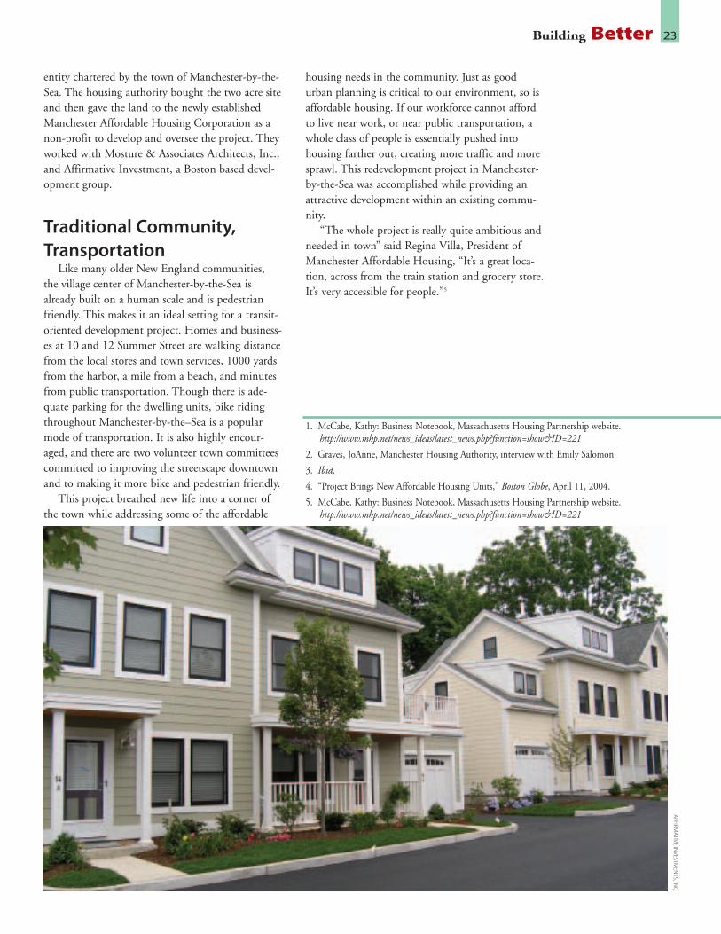
Located approximately 30 miles north of Boston, and along the Atlantic Ocean, Manchester-by-the-Seais an affluent residential community in Massachusetts. On 2.2 acres in the center of town, just astone’s throw from a commuter rail station that travels along the North Shore into Boston, the local
housing authority pursued a smart growth project to provide a mixed-income, mixed-use infill project. Theaffordable housing development is one of the largest ever for Manchester-by-the-Sea, which is among theregion’s priciest communities.
AFFIRM
ATIVE
INVESTM
ENTS,IN
C.
MASSACHUSETTS
Manchester-by-the-Sea
entity chartered by the town of Manchester-by-the-Sea. The housing authority bought the two acre siteand then gave the land to the newly establishedManchester Affordable Housing Corporation as anon-profit to develop and oversee the project. Theyworked with Mosture & Associates Architects, Inc.,and Affirmative Investment, a Boston based devel-opment group.
Traditional Community,Transportation
Like many older New England communities,the village center of Manchester-by-the-Sea isalready built on a human scale and is pedestrianfriendly. This makes it an ideal setting for a transit-oriented development project. Homes and business-es at 10 and 12 Summer Street are walking distancefrom the local stores and town services, 1000 yardsfrom the harbor, a mile from a beach, and minutesfrom public transportation. Though there is ade-quate parking for the dwelling units, bike ridingthroughout Manchester-by-the–Sea is a popularmode of transportation. It is also highly encour-aged, and there are two volunteer town committeescommitted to improving the streetscape downtownand to making it more bike and pedestrian friendly.
This project breathed new life into a corner ofthe town while addressing some of the affordable
housing needs in the community. Just as goodurban planning is critical to our environment, so isaffordable housing. If our workforce cannot affordto live near work, or near public transportation, awhole class of people is essentially pushed intohousing farther out, creating more traffic and moresprawl. This redevelopment project in Manchester-by-the-Sea was accomplished while providing anattractive development within an existing commu-nity.
“The whole project is really quite ambitious andneeded in town” said Regina Villa, President ofManchester Affordable Housing, “It’s a great loca-tion, across from the train station and grocery store.It’s very accessible for people.”5
Building Better 23A
FFIRMA
TIVEIN
VESTMEN
TS,INC
.
1. McCabe, Kathy: Business Notebook, Massachusetts Housing Partnership website.http://www.mhp.net/news_ideas/latest_news.php?function=show&ID=221
2. Graves, JoAnne, Manchester Housing Authority, interview with Emily Salomon.
3. Ibid.
4. “Project Brings New Affordable Housing Units,” Boston Globe, April 11, 2004.
5. McCabe, Kathy: Business Notebook, Massachusetts Housing Partnership website.http://www.mhp.net/news_ideas/latest_news.php?function=show&ID=221

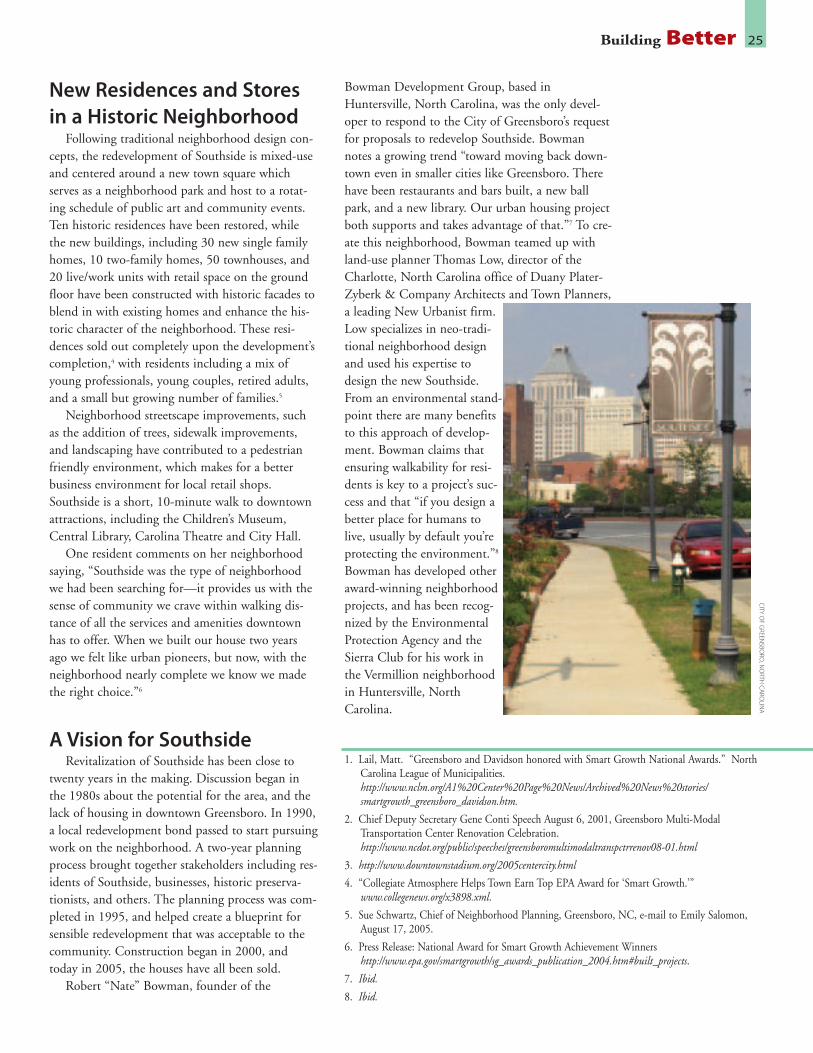
Location, Location, LocationThe location of the Southside neighborhood
enhances the redevelopment. In the southern part ofdowntown, the neighborhood is short distance fromthe city’s historic downtown. Two major bus linesrun through the 10-acre neighborhood, and it iswalking distance from a multi-modal transportationcenter that has been recently renovated, bringingtogether the city buses, intercity buses, coaches, taxis,and intercity rail services.2 Future plans for the hubinclude light rail, high-speed rail, a farmers market,
and occupied restaurant space.3 The completion ofthe transportation center renovation in 2001 was alandmark since it is the first multi-modal transit cen-ter in North Carolina, and it marks the city’s effortto promote multiple transportation options forGreensboro residents while addressing traffic conges-tion. A proposed “Rail Yard Park,” will run for amile between the Southside neighborhood and thetransportation terminal, creating an easy, safe corri-dor for pedestrians to travel between public trans-portation and their residences and work.
Building Better 24
SouthsideNeighborhood
Greensboro
Located minutes walking distance from the central business district, one of Greensboro’s most histori-cally affluent neighborhoods—Southside—experienced increasing disinvestment and decay afterWorld War II. Starting in the late 1980s, the Greensboro City Council addressed the possibility of
redeveloping the Southside neighborhood, which was then considered blighted. At the time it was unchartedterritory, but the City of Greensboro foresaw the full potential this neighborhood would have if redevelopedusing Smart Growth principles. The City’s Community Development Director, Andy Scott, said: “We areusing the principles of smart growth to protect and enhance our natural environment. By reusing previouslydeveloped land; providing more housing and transportation choices; preserving critical natural areas; anddeveloping vibrant places throughout Greensboro, we are protecting our air, water, and land for future gen-erations to enjoy.”1 Targeting many historic homes and abandoned properties for preservation and renova-tion, rezoning the district for mixed-use development, and creating a master plan for the district has allresulted in the first mixed-use infill development project in the state, which has received wide recognition,including a Smart Growth award by the federal Environmental Protection Agency.
CITY
OF
GREEN
SBORO
,NO
RTHC
ARO
LINA
NORTH CAROLINA
New Residences and Storesin a Historic Neighborhood
Following traditional neighborhood design con-cepts, the redevelopment of Southside is mixed-useand centered around a new town square whichserves as a neighborhood park and host to a rotat-ing schedule of public art and community events.Ten historic residences have been restored, whilethe new buildings, including 30 new single familyhomes, 10 two-family homes, 50 townhouses, and20 live/work units with retail space on the groundfloor have been constructed with historic facades toblend in with existing homes and enhance the his-toric character of the neighborhood. These resi-dences sold out completely upon the development’scompletion,4 with residents including a mix ofyoung professionals, young couples, retired adults,and a small but growing number of families.5
Neighborhood streetscape improvements, suchas the addition of trees, sidewalk improvements,and landscaping have contributed to a pedestrianfriendly environment, which makes for a betterbusiness environment for local retail shops.Southside is a short, 10-minute walk to downtownattractions, including the Children’s Museum,Central Library, Carolina Theatre and City Hall.
One resident comments on her neighborhoodsaying, “Southside was the type of neighborhoodwe had been searching for—it provides us with thesense of community we crave within walking dis-tance of all the services and amenities downtownhas to offer. When we built our house two yearsago we felt like urban pioneers, but now, with theneighborhood nearly complete we know we madethe right choice.”6
A Vision for SouthsideRevitalization of Southside has been close to
twenty years in the making. Discussion began inthe 1980s about the potential for the area, and thelack of housing in downtown Greensboro. In 1990,a local redevelopment bond passed to start pursuingwork on the neighborhood. A two-year planningprocess brought together stakeholders including res-idents of Southside, businesses, historic preserva-tionists, and others. The planning process was com-pleted in 1995, and helped create a blueprint forsensible redevelopment that was acceptable to thecommunity. Construction began in 2000, andtoday in 2005, the houses have all been sold.
Robert “Nate” Bowman, founder of the
Bowman Development Group, based inHuntersville, North Carolina, was the only devel-oper to respond to the City of Greensboro’s requestfor proposals to redevelop Southside. Bowmannotes a growing trend “toward moving back down-town even in smaller cities like Greensboro. Therehave been restaurants and bars built, a new ballpark, and a new library. Our urban housing projectboth supports and takes advantage of that.”7 To cre-ate this neighborhood, Bowman teamed up withland-use planner Thomas Low, director of theCharlotte, North Carolina office of Duany Plater-Zyberk & Company Architects and Town Planners,a leading New Urbanist firm.Low specializes in neo-tradi-tional neighborhood designand used his expertise todesign the new Southside.From an environmental stand-point there are many benefitsto this approach of develop-ment. Bowman claims thatensuring walkability for resi-dents is key to a project’s suc-cess and that “if you design abetter place for humans tolive, usually by default you’reprotecting the environment.”8
Bowman has developed otheraward-winning neighborhoodprojects, and has been recog-nized by the EnvironmentalProtection Agency and theSierra Club for his work inthe Vermillion neighborhoodin Huntersville, NorthCarolina.
Building Better 25C
ITYO
FG
REENSBO
RO,N
ORTH
CA
ROLIN
A
1. Lail, Matt. “Greensboro and Davidson honored with Smart Growth National Awards.” NorthCarolina League of Municipalities.http://www.nclm.org/A1%20Center%20Page%20News/Archived%20News%20stories/smartgrowth_greensboro_davidson.htm.
2. Chief Deputy Secretary Gene Conti Speech August 6, 2001, Greensboro Multi-ModalTransportation Center Renovation Celebration.http://www.ncdot.org/public/speeches/greensboromultimodaltranspctrrenov08-01.html
3. http://www.downtownstadium.org/2005centercity.html
4. “Collegiate Atmosphere Helps Town Earn Top EPA Award for ‘Smart Growth.’”www.collegenews.org/x3898.xml.
5. Sue Schwartz, Chief of Neighborhood Planning, Greensboro, NC, e-mail to Emily Salomon,August 17, 2005.
6. Press Release: National Award for Smart Growth Achievement Winnershttp://www.epa.gov/smartgrowth/sg_awards_publication_2004.htm#built_projects.
7. Ibid.
8. Ibid.
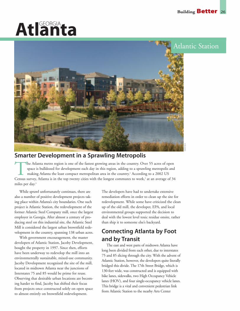
While sprawl unfortunately continues, there arealso a number of positive development projects tak-ing place within Atlanta’s city boundaries. One suchproject is Atlantic Station, the redevelopment of theformer Atlantic Steel Company mill, once the largestemployer in Georgia. After almost a century of pro-ducing steel on this industrial site, the Atlantic SteelMill is considered the largest urban brownfield rede-velopment in the country, spanning 138 urban acres.
With government encouragement, the masterdevelopers of Atlantic Station, Jacoby Development,bought the property in 1997. Since then, effortshave been underway to redevelop the mill into anenvironmentally sustainable, mixed-use community.Jacoby Development recognized the site of the mill,located in midtown Atlanta near the junctions ofInterstates 75 and 85 would be prime for reuse.Observing that desirable urban locations are becom-ing harder to find, Jacoby has shifted their focusfrom projects once constructed solely on open spaceto almost entirely on brownfield redevelopment.
The developers have had to undertake extensiveremediation efforts in order to clean up the site forredevelopment. While some have criticized the cleanup of the old mill, the developer, EPA, and localenvironmental groups supported the decision todeal with the lowest level toxic residue onsite, ratherthan ship it to someone else’s backyard.
Connecting Atlanta by Footand by Transit
The east and west parts of midtown Atlanta havelong been divided from each other, due to interstates75 and 85 slicing through the city. With the advent ofAtlantic Station, however, the developers quite literallybridged this divide. The 17th Street Bridge, which is130-feet wide, was constructed and is equipped withbike lanes, sidewalks, two High Occupancy Vehiclelanes (HOV), and four single-occupancy vehicle lanes.This bridge is a vital and convenient pedestrian linkfrom Atlantic Station to the nearby Arts Center
Building Better 26
Atlantic Station
Atlanta
Smarter Development in a Sprawling Metropolis
The Atlanta metro region is one of the fastest growing areas in the country. Over 55 acres of openspace is bulldozed for development each day in this region, adding to a sprawling metropolis andmaking Atlanta the least compact metropolitan area in the country.1 According to a 2002 US
Census survey, Atlanta is in the top twenty cities with the longest commutes to work,2 at an average of 34miles per day.3
EDELM
AN
GEORGIA

Station of the city’s subway system known as theMetropolitan Atlanta Rapid Transit Authority(MARTA). The bridge itself was constructed withflexible funding made possible due to the project’s“smart growth” location. Atlantic Station’s developers,Jacoby, collaborated with the federal EnvironmentalProtection Agency (EPA) on the bridge project.Because Atlanta failed to meet federal air pollutionstandards, this bridge was deemed an important linkto public transportation which would take cars off theroad and reduce air pollution. Making bridge fundingavailable, the EPA noted that the Atlantic Stationdevelopment would “produce less air pollution thanan equivalent amount of development at other likelysites in the region.”4 A fleet of electric shuttles will alsoserve Atlantic Station and run a free service betweenthe development and the MARTA station.5 In thespirit of making this development truly transitdependent, parking is limited and priority for parkingspaces is made for vans and shared carpool vehicles.Atlantic Station is among the largest scale transit-ori-ented development project in the nation.
A Place to Live, Work andShop
Calling itself a “live-work-play community,” a largeportion of Atlantic Station will be composed of resi-dential units. Currently, 56 townhomes, 347 condo-miniums, and 231 one- and two-bedroom apartmentshave been completed, and are almost all occupied.The additional six buildings are under constructionand are all set open their doors for occupancythroughout 2006.6 When the project is fully complet-ed, there will be between 3,000 to 5,000 residentialunits available and it is expected to have a populationof 10,000 residents. There are a number of homeown-ership and rental options, with a variety of condo-miniums, townhouses, and apartments on the market.Rental units start at $675/month; some of the owner-ship condos range from $100,000 to $300,000; loftsbegin in the $300,000s, and townhomes range from$385,000 to $700,000. There is a waiting list for themany of the new homes that are available now or inthe construction phase, illustrating the high demandfor urban living in close proximity to other amenities.Residential properties and rentals are varied, and thepeople moving to Atlantic Station are diverse: families,young professionals, executives, college students, andmarried couples all live in Atlantic Station.
There is also a retail component to AtlanticStation, which opened in 2004. Approximately thirtynational retailers have stores in Atlantic Station, as well
as a dozen or more restaurants. A movie theater is alsocoming for a total of 1.5 million square feet of retail.Though already functioning, the grand opening forthe completion of the retail and entertainment districtis set for October 2005. A hotel with 1,000 rooms isexpected to open in the winter of 2006. The firstcommercial tower, 171 17th Street, has been complet-ed, with a 90 percent occupancy rate as of May 2005.7
It was constructed using LEED standards as a guide-line for sustainable design, with a special heat-reflect-ing roof, water-saving bathrooms, and natural land-scaping to conserve water.8 More office towers are inthe planning phase and will similarly be built accord-ing to LEED standards,9 and once completed, AtlanticStation will have 6 million square feet of office space.Additionally, over 2,500 trees have been plantedthroughout the community, and when the Station isfinished there will be 11 acres of green space.
A Smarter AtlantaAtlantic Station is not perfect, but it is creating
good steps in the right direction that will influence thefuture of Atlanta. Since the high-density residentialunits have been wildly successful, it shows the demandfor urban living. This sets a precedent that can guidefuture development to provide more housing units inthe city. Additionally, city transportation has improvedbecause of Atlantic Station, at little cost to the taxpay-er. Jacoby Development made a commitment to payfor the shuttle that will service Atlantic Station andthe closest MARTA station, and has connected differ-ent points in the city with a choice of transportationoptions that were previously not easily accessible. Thisproject started dialogue about transportation access inAtlanta and has influenced changes in the way theGeorgia Department of Transportation operates.
Building Better 27
1. Atlantic Station FAQs. http://www.atlanticstation.com/concept_green_projectXL.php, & Page 2, 17117th Street, at the Atlantic Station Development. http://www.atlanticstation.com/work/171.pdf.
2. US Census Bureau, American Community Survey: Average Time to Work of Workers 16 andOver Who Did Not Work at Home (Minutes) Workers 16 and Over (Place Level)http://www.census.gov/acs/www/Products/Ranking/2002/R04T160.htm.
3. Page 2, 171 17th Street, at the Atlantic Station Development.http://www.atlanticstation.com/work/171.pdf.
4. Project XL: The Atlantic Steel Redevelopment. Environmental Protection Agency.http://www.epa.gov/projectxl/atlantic/atlanticfact02.pdf.
5. http://www.atlanticstation.com/site_transit.php
6. Kristen Stone E-mail to Emily Salomon, “Residential Overview/Fact Sheet,” 7/29/05.
7. Atlantic Station Fact Sheet: Retail, Office Commitments. July 2005.
8. Page 3, 171 17th Street, at the Atlantic Station Development.http://www.atlanticstation.com/work/171.pdf
9. Kristen Stone Email 8/1/05
10. Phone Interview Bryan Hager July 27, 2005.
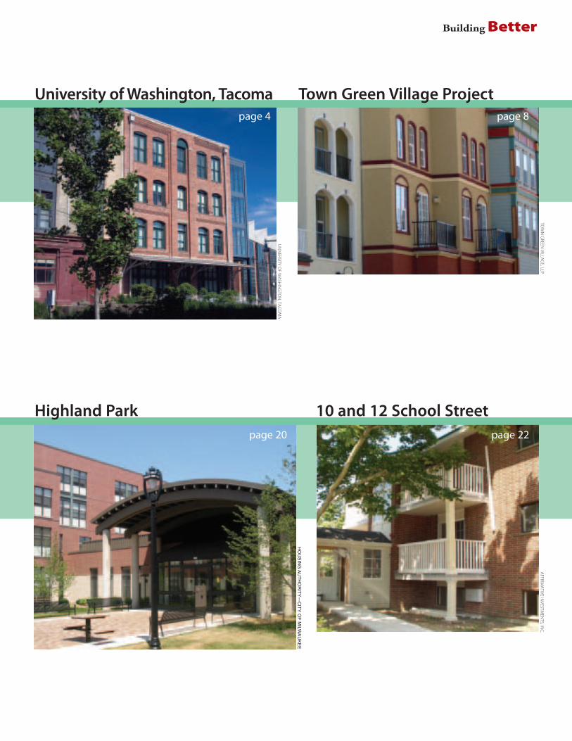
Building Better
Highland Park 10 and 12 School Street
AFFIRM
ATIVE
INVESTM
ENTS,IN
C.
HO
US
ING
AU
TH
OR
ITY
—C
ITY
OF
MILW
AU
KE
E
UN
IVERSITYO
FW
ASH
ING
TON
,TAC
OM
A
TOW
NG
REENVILLA
GE,LLP
page 4
page 20 page 22
Town Green Village ProjectUniversity of Washington, Tacomapage 8

Building Better
EDELM
AN
The Pearl District
Atlantic Station
SCO
TTC
HA
PMA
N
page 6
page 26
page 14
MA
RCH
EILESON
BetterBuilding
Salt Lake City

www.sierraclub.org/sprawl