Experience the North Cascades: Highway 20 Hikes and … · Experience the North Cascades: Highway...
2
# # # # # # # # # # # # # # # # # # # # # # # # # # # # # # # # # # # # # # # # # # # # # # # # # # # # # # # # # # # # # # # ? ¨ ? ¨ ? ¨ ! ! ! ! ! ! ! ! ! ! ! ! ! ! F ! ! F ! ! F ! ! F ! ! F ! 9 ! 9 ! 9 ! ! F ! ! F ! ! F ! ! F ! ! F ! 9 ! 9 ! 9 ! 9 ! [ ! [ ! [ ! _ ! 5 ! 5 ! @ ! ! F ! ! F ! ! F ! ! F ! ! F ! ! F ! ! F ! ! F ! ! F ! ! F " " " " " " " " " " " " " " " " ROSS LAKE NATIONAL RECREATION AREA PASAYTEN WILDERNESS LAKE CHELAN- NORTH CASCADES NATIONAL PARK Ross Lake Diablo Lake Gorge Lake Blue Lake Rainy Lake Rainy Pass Trails R i v er M e t h o w R iv e r Newhalem Area Trails Diablo Lake Trail Gorge Creek Falls Trail Thunder Knob Trail Happy Creek Forest Walk Newhalem Creek Sourdough Trail Thunder/Park Creek Trail Ross Dam Trail Lone Fir Loop Interpretive Trail ! ! Bridge Creek Trailhead Blue Lake Trailhead Cutthroat Lake Trail Cedar Creek Trailhead Easy Pass Trailhead Pacific Crest Trail East Creek Trailhead Canyon Creek Trail Diablo Lake Overlook Ross Lake Overlook Washington Pass Overlook North Cascades Institute NPS Visitor Center Mazama Newhalem 120 Lo st Rive r Road Lone Fir Campground Klipchuck Campground Early Winters Campground C H E L A N S K A G I T O K A N O G A N W H A T C O M Tatie Peak Goode Mountain Inspiration Peak Jack Mountain Mt. Terror Cutthroat Peak Crater Mountain Butte Mt. Arriva Mt. Benzarino Black Peak Booker Mountain Buckner Mountain Corteo Peak Fisher Peak Frisco Mountain Horseshoe Peak Liberty Bell Mountain Sahale Mountain Storm King Whistler Mountain Abernathy Peak Beauty Peak Blackcap Mountain Devils Peak Gardner Mountain Gibert Mountain Golden Horn Holliway Mountain Lake Mountain Lost Peak Monument Peak North Gardner Mountain Pasayten Peak Mt. Logan Pistol Peaks Robinson Mountain Robinson Peak Mt. Rolo Silver Star Mountain Stiletto Peak Storey Peak Wildcat Mountain Austera Peak Azurite Peak Boston Peak Cosho Peak Forbidden Peak Gabriel Peak The Horseman Katsuk Peak Kimtah Peak Kitling Peak Klawatti Peak Mesahchie Peak Primus Peak Red Mountain Snowfield Peak Tower Mountain Tricouni Peak Mt. Ballard Colonial Peak Diablo Barron Anacortes Crossing Cedar Crossing 123 129 134 141 158 167 169 ! ! F Featured Trailheads ! ! F Other Trailheads Trails ! @ Visitor Centers ! 9 Campsites ! [ Scenic Stops ! 5 Picnic Area ! _ Restroom ! ! Cities and Towns # Summits Highways " " Mile Markers Lakes Rivers and Streams County Boundaries 0 1 2 Miles Á September 16, 2014 Land Ownership National Wilderness Area National Park National Forest National Recreation Area Cartography by CORE GIS LLC www.coregis.net Experience the North Cascades: Highway 20 Hikes and Sights www.wilderness.org/ northcascadesmaps Find this map online: To Sedro- Woolley, Darrington To Winthrop
Transcript of Experience the North Cascades: Highway 20 Hikes and … · Experience the North Cascades: Highway...
#
#
#
#
#
#
#
#
#
#
#
# #
#
#
#
#
#
#
#
#
#
#
#
#
#
#
#
#
#
#
#
#
#
#
#
#
#
#
#
#
#
#
#
#
#
#
#
#
#
#
#
#
#
#
#
#
##
#
#
##
#
#
#
#
#
#
#
#
#
#
#
# #
#
#
#
#
#
#
?̈
?̈
?̈
?̈
!!
!!
!!
!!
!!
!!
!!
!!F
!!F
!!F!!F
!!F
!9
!9 !9
!!F!!F
!!F!!F
!!F !!F
!!F
!!F
!!F!!F
!!F
!!F
!!F
!!F
!9
!9
!9
!9
!9

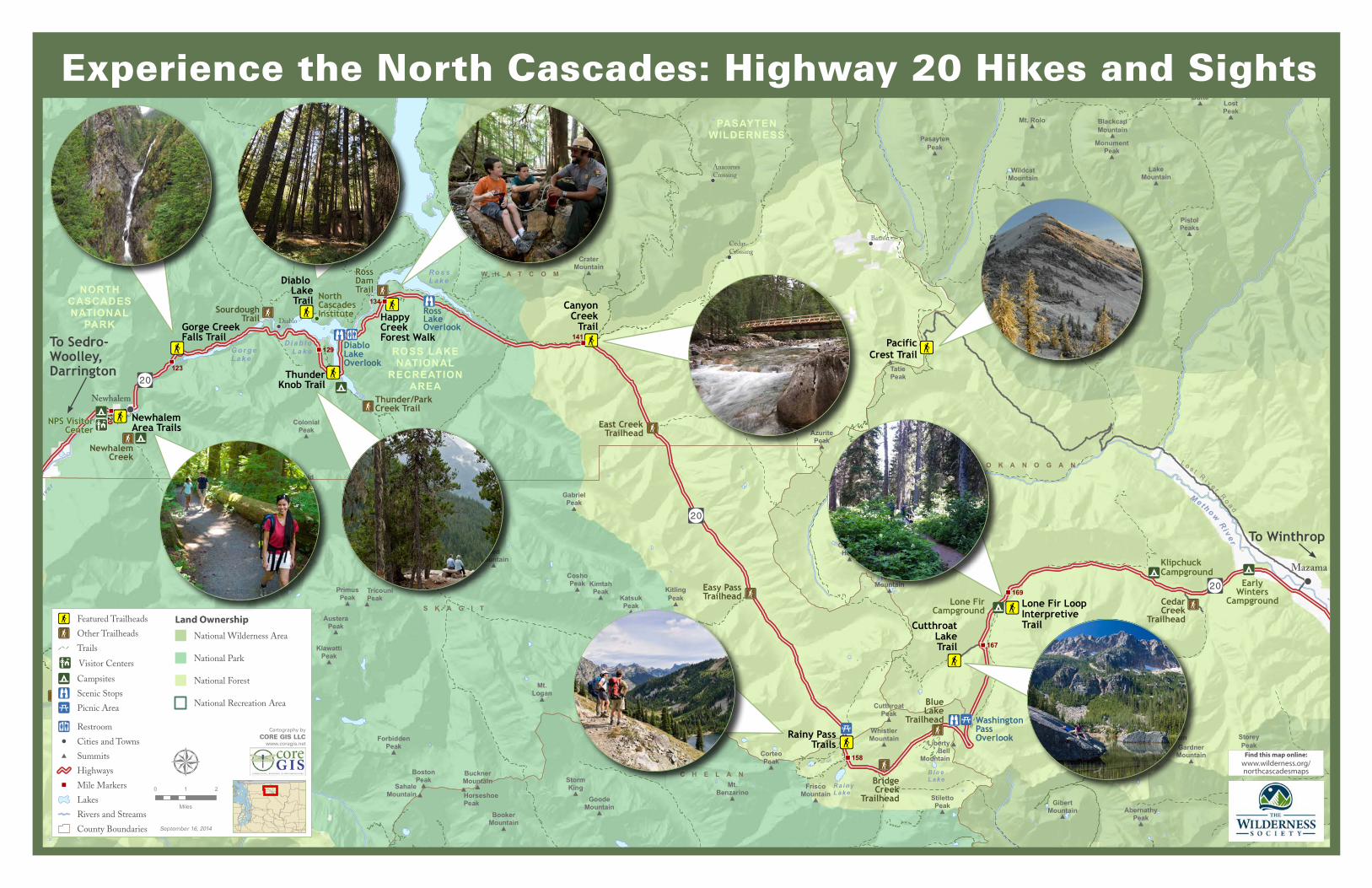
Highway 20 Featured Hikes & Sights Resources Newhalem Area Trails• Explore the lush forest environment and creeks of Newhalem
through a variety of easy trails. Interpretive signs help you learn along the way.
• Several trails depart from the North Cascades National Park Visitor Center, located south of Highway 20 at milepost 120. Restrooms available. Trails also depart from the Newhalem campground and Main Street in Newhalem.
Cascade Loop Scenic Highwaywww.cascadeloop.com, (509) 662-3888Cascade Loop Scenic Highway provides visitor information for com-munities along the 440-mile Cascade Loop Scenic Highway. Contact the Chambers of Commerce in Winthrop (888) 463-8469 and Concrete for more local tourist information (360) 853-8767.
North Cascades Institutewww.ncascades.org, (360) 854-2599North Cascades Institute seeks to inspire a closer relationship with nature through direct experiences in the natural world. The Institute provides a wide variety of workshops, classes, and tours. Visit the Institute’s Environmental Learning Center on the north shore of Diablo Lake.
North Cascades National Parkwww.nps.gov/noca, (360) 854-7200North Cascades National Park Service Complex is made up of three units managed as one: North Cascades National Park, Ross Lake, and Lake Chelan National Recreation Area. More than 90 percent of the complex is managed as the Stephen Mather Wilderness. Visit the North Cascades Visitor Center in Newhalem and the Wilderness Support Center near Marblemount for hiking and permit informa-tion.
Okanogan-Wenatchee National Forestwww.fs.usda.gov/okawen, (509) 996-4003 (Methow Ranger District)The Okanogan-Wenatchee National Forest stretches north to south from the Canadian border to the base of Mt. Rainier, and east of the Cascade Crest to the Okanogan highlands. The Methow Valley Ranger District extends from the town of Twisp to the crest of the Cascades in the Pasayten Wilderness and North Cascades National Park.
REI Guidepostwww.rei.com/guidepostREI is a national outdoor retail co-op dedicated to inspiring, educat-ing, and outfitting its members and the community for a lifetime of outdoor adventure and stewardship. The REI Guidepost provides detailed information and an interactive map of recreational activities for areas such as the North Cascades.
The Wilderness Societywww.wilderness.org, (206) 624-6430The Wilderness Society (TWS) protects and enhances the wild lands and waters of the North Cascades and beyond and inspires communities to care for our public lands. TWS works with a variety of partners to protect wild lands and waters, expand recreational op-portunities, and steward our natural resources.
Washington Trails Associationwww.wta.org, (206) 625-1367 Washington Trails Association’s (WTA) mission is to preserve, enhance, and promote hiking opportunities through collaboration, education, advocacy, and volunteer trail maintenance. Visit WTA’s website to access a wealth of hiking resources and learn about volun-teer opportunities.
Gorge Creek Falls Trail• Experience the roar and mists of Gorge Creek Falls as they tumble
right to the highway. A short trail leads to an overlook and more waterfalls.
• Located south of Highway 20 at milepost 123. Restrooms available.
Diablo Lake Trail• View snowy peaks and glacial-fed Diablo Lake from this quiet
trail. Mossy forests, boulder fields, and overlooks make any portion of this four-mile trail (one-way) a great excursion.
• Drive across Diablo Dam at milepost 127.5 then turn right. Access the trail at the trailhead on the left across from North Cascades Institute’s parking lot.
Thunder Knob Trail• Take a two-mile trail (one-way) up to Thunder Knob, perched
above Diablo Lake. Bridges, moss-covered ledges, forests of hemlock and pine, and overlooks delight you along the way.
• Located north of Highway 20 at the Colonial Campground near milepost 130; parking is to the right of the entrance. Water and restrooms available.
Happy Creek Forest Walk • Explore this half-mile interpretive trail loop through tall trees and
along bubbling Happy Creek. A steeper, rustic trail (1.8 miles) to Happy Creek Falls is accessible from this boardwalk.
• Located south of Highway 20 between mileposts 134 and 135. Restrooms available.
Canyon Creek Trail• Explore two creeks, two bridges, and an historic cabin along
Canyon Creek in less than a mile (one-way). For a longer hike, continue your trip along Canyon Creek.
• Located north of Highway 20 near milepost 141. Restrooms available. Northwest Forest Pass required.
Rainy Pass Trails• Stretch your legs at Rainy Pass, where you can find rewarding
hikes of various lengths. A one-mile trail leads you to scenic Rainy Lake; a two-mile trail takes you to Lake Ann; and a longer loop trail offers alpine meadows and views of majestic peaks along Heather and Maple passes.
• Located south of Highway 20 near milepost 158 at the Rainy Pass Picnic Area. Restrooms and water available. Northwest Forest Pass required.
Cutthroat Lake Trail• Take a gentle, two-mile trail (one-way) along Cutthroat Creek
and past lichen-covered granite boulders to Cutthroat Lake, surrounded by rocky cliffs. For a longer hike, continue 3.8 miles to Cutthroat Pass.
• Located north of Highway 20 near milepost 167, turn onto Forest Road 400, continue one mile to the trailhead. Restrooms available. Northwest Forest Pass required.
Lone Fir Loop Interpretive Trail• Explore this two-mile interpretive loop trail that departs from the
Lone Fir campground and follows Early Winters Creek. • Located south of Highway 20 between mileposts 168 and 169
at the Lone Fir Campground. Restrooms and limited parking available.
Pacific Crest Trail (to Tatie Peak)• Follow the Pacific Crest Trail for two miles across alpine meadows
to breathtaking views of Tatie Peak. • Take Lost River Road (or Harts Pass Road 5400) east from
Mazama 18.5 miles to Harts Pass (this mostly dirt road can be rough, especially the last few miles). At the pass, turn south onto Spur Road 54-500 to Meadows Campground; continue two miles beyond campground to the trailhead.
Seattle City Lightwww.seattlegov/light, (206) 684-3030Seattle City Light has generated hydroelectric power on the Skagit River since 1918. Today three dams provide power to the citizen-owners in Seattle. Seattle City Light provides several tours to learn about the North Cascades and its long history of environmental stewardship along the Skagit River.
Map and Permit InformationThis map is intended to help you access easier, rewarding hikes in the North Cascades. Green Trails Maps are recommended for navigational purposes on hiking trails. You can purchase Green Trails Maps online at www.greentrails.com or at a local vendor. Many recreation destinations require a pass:
Discover Pass: $35 annual, $11.50 daily. Required at Washington state-managed recreation lands. Available at www.discoverpass.wa.gov, in person from any hunting or fishing license vendor, and by phone: (866) 320-9933.
National Forest Recreation Day Pass: $5. Required at all Forest Service day use or entrance fee sites in Washington or Oregon. Available at National Forest offices and visitor centers, via private vendors, or www.discovernw.org.
Northwest Forest Pass: $30. Annual pass honored at all Forest Service day use or entrance fee sites in Washington or Oregon. Available at National Forest offices and visitor centers, via private vendors or www.discovernw.org.
Interagency Annual Pass: $80. Annual pass honored at all federal recreation sites charging day use or entrance fees. Available at National Forest offices or
www.discovernw.org.
Interagency Senior Pass: $10. Lifetime pass for those 62 and older honored at all federal recreation sites charging day use or entrance fees. Passes issued in person; available at National Forest offices.
Interagency Military Pass, Interagency Access Pass: Free. Passes for active duty military and their dependents as well as individuals with a permanent disability honored at all federal sites charging day use or entrance fees. Passes issued in person; available at National Forest offices.
Photo: Holly Werran, courtesy of REI
Photo: Amit Patel
Photo: North Cascades National Park
Photo: D. Parrish, courtesy of REI
Photo: Dave Snyder
Photo: Richard Cassan
Photo: Holly Werran, courtesy of REI
Photo: Steph Taylor
Photo: Jason Hollinger
Photo: Dave Snyder