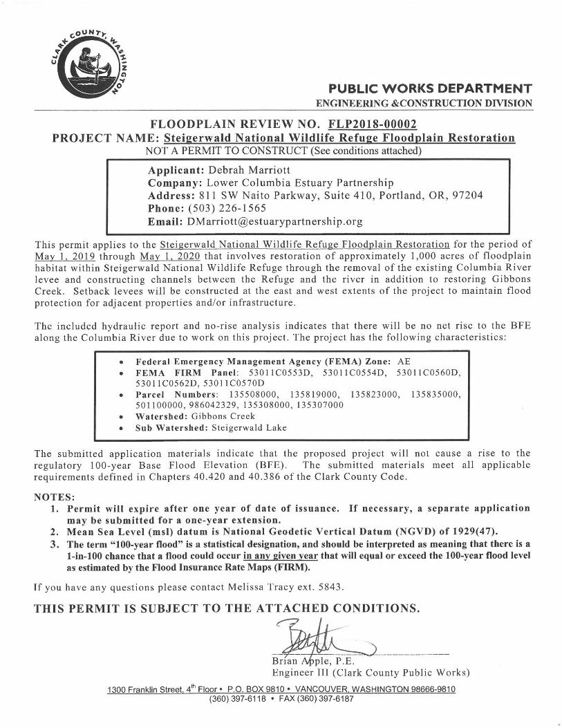
EXHIBIT 2 REGULATORY PERMITS - Estuary Partnership › sites › default › files › Exhibit...
115
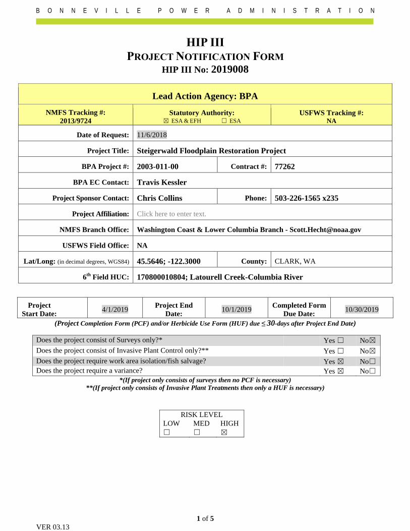
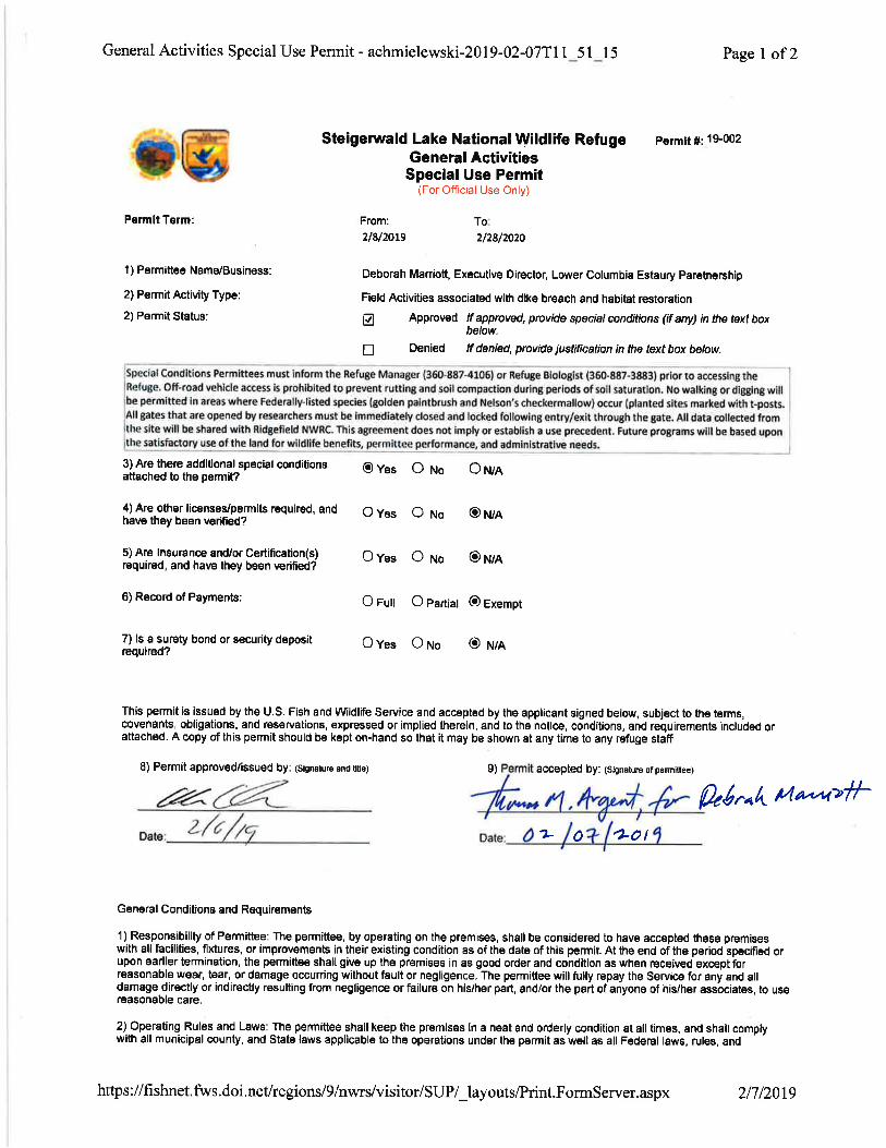
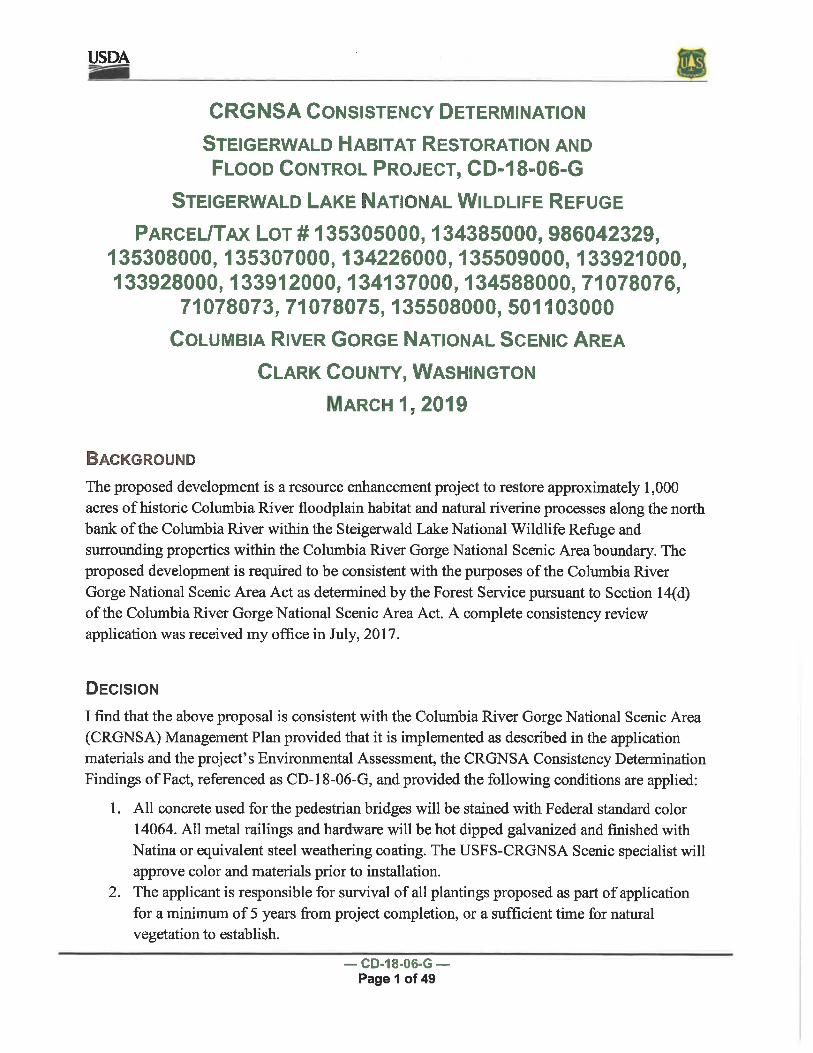
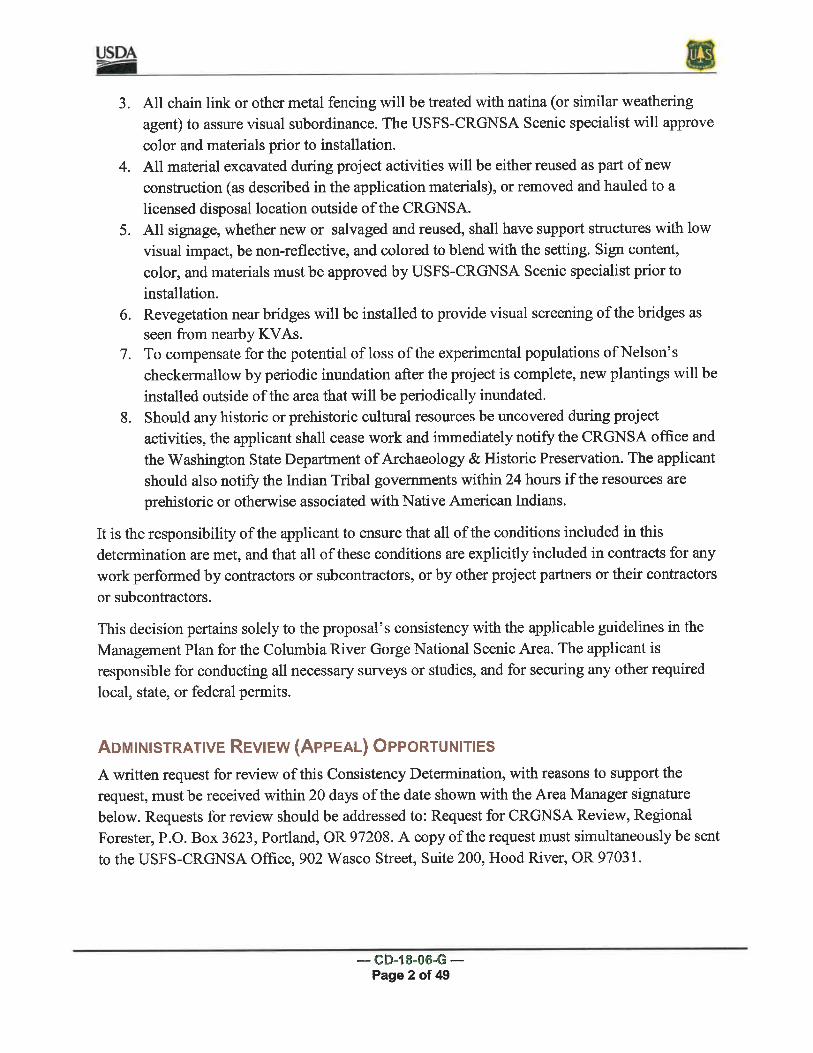
EXHIBIT 2 REGULATORY PERMITS Several regulatory agencies require permit approvals prior to initiating the project. The Contractor agrees to comply fully with all applicable federal, state, and local laws and regulations including, but not limited to, the regulatory permits included or referenced in Exhibit 2. Exhibit 2 includes regulatory approvals from the following agencies for the following permits: • BONNEVILLE POWER ADMINISTRATION (National Environmental Policy Act; DOE/EA-2027 dated January 2018 • CLARK COUNTY (State Environmental Policy Act; Notice of Final Determination dated May 1, 2019) • CLARK COUNTY (Floodplain Review; Floodplain Review No. FLP2018-00002 dated May 1, 2019) • NATIONAL MARINE FISHERIES SERVICE (Section 7 of the ESA; Project Notification Form, HIP III No. 2019008 dated November 6, 2018 and associated Programmatic No. 2013-F-0199 dated November 8, 2013) • U.S. FISH AND WILDLIFE SERVICE (Section 7 of the ESA; Intra-Service Section 7 Biological Evaluation dated May 12, 2016) • U.S. FISH AND WILDLIFE SERVICE (Steigerwald Lake National Wildlife Refuge General Activities Special Use Permit; Permit No. 19-002 signed February 7, 2019) • U.S. FOREST SERVICE (Columbia River Gorge National Scenic Area Act; CRGNSA Consistency Determination 18-06-G dated March 1, 2019) • WASHINGTON DEPARTMENT OF ARCHAEOLOGY AND HISTORIC PRESERVATION (Section 106 of the National Historic Preservation Act; Memorandum of Agreement signed September 24, 2018) • WASHINGTON DEPARTMENT OF FISH & WILDLIFE (Hydraulic Project Approval – Permit No. 2019-5-8+01 dated January 17, 2019) The Owner has submitted the following permit applications, which are pending approval. The Owner will provide written approvals to the Contractor as soon as they are received. • CLARK COUNTY (Shoreline Exemption) • CLARK COUNTY (Wetland/Habitat Determination) • U.S. ARMY CORPS OF ENGINEERS (Section 404 of the Clean Water Act) • WASHINGTON DEPARTMENT OF ECOLOGY (Const. Stormwater General Permit) • WASHINGTON DEPARTMENT OF ECOLOGY (Section 401 Water Quality Certification)
Transcript of EXHIBIT 2 REGULATORY PERMITS - Estuary Partnership › sites › default › files › Exhibit...

EXHIBIT 2
REGULATORY PERMITS
Several regulatory agencies require permit approvals prior to initiating the project. The Contractor agrees to comply fully with all applicable federal, state, and local laws and regulations including, but not limited to, the regulatory permits included or referenced in Exhibit 2. Exhibit 2 includes regulatory approvals from the following agencies for the following permits:
• BONNEVILLE POWER ADMINISTRATION (National Environmental Policy Act; DOE/EA-2027 dated January 2018
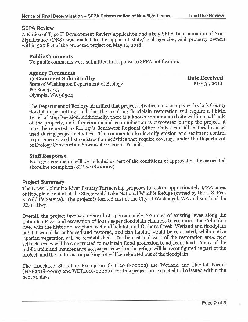
• CLARK COUNTY (State Environmental Policy Act; Notice of Final Determination dated May 1, 2019) • CLARK COUNTY (Floodplain Review; Floodplain Review No. FLP2018-00002 dated May 1, 2019) • NATIONAL MARINE FISHERIES SERVICE (Section 7 of the ESA; Project Notification Form, HIP III No. 2019008
dated November 6, 2018 and associated Programmatic No. 2013-F-0199 dated November 8, 2013) • U.S. FISH AND WILDLIFE SERVICE (Section 7 of the ESA; Intra-Service Section 7 Biological Evaluation dated
May 12, 2016) • U.S. FISH AND WILDLIFE SERVICE (Steigerwald Lake National Wildlife Refuge General Activities Special Use
Permit; Permit No. 19-002 signed February 7, 2019) • U.S. FOREST SERVICE (Columbia River Gorge National Scenic Area Act; CRGNSA Consistency Determination
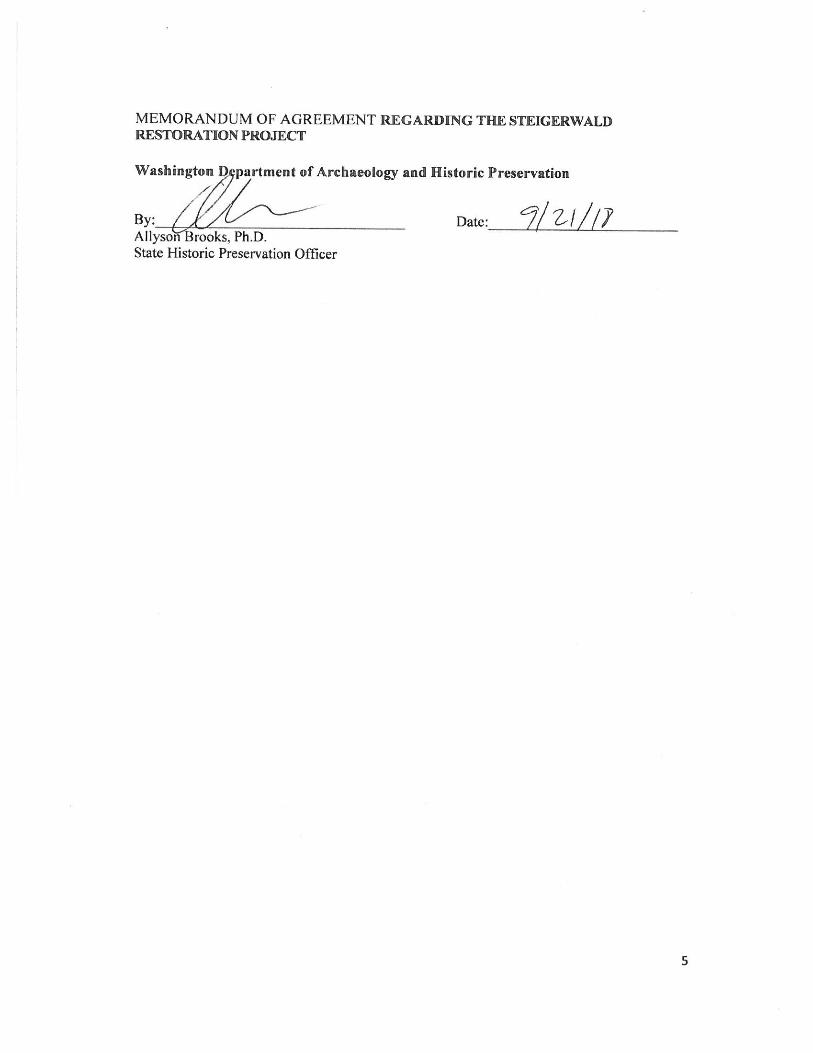
18-06-G dated March 1, 2019) • WASHINGTON DEPARTMENT OF ARCHAEOLOGY AND HISTORIC PRESERVATION (Section 106 of the
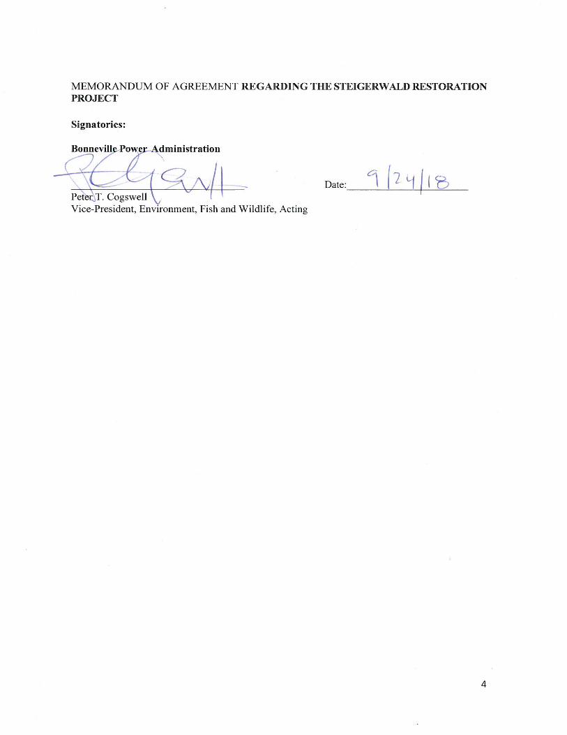
National Historic Preservation Act; Memorandum of Agreement signed September 24, 2018) • WASHINGTON DEPARTMENT OF FISH & WILDLIFE (Hydraulic Project Approval – Permit No. 2019-5-8+01
dated January 17, 2019) The Owner has submitted the following permit applications, which are pending approval. The Owner will provide written approvals to the Contractor as soon as they are received.
• CLARK COUNTY (Shoreline Exemption) • CLARK COUNTY (Wetland/Habitat Determination) • U.S. ARMY CORPS OF ENGINEERS (Section 404 of the Clean Water Act) • WASHINGTON DEPARTMENT OF ECOLOGY (Const. Stormwater General Permit) • WASHINGTON DEPARTMENT OF ECOLOGY (Section 401 Water Quality Certification)
1
Department of Energy
Bonneville Power Administration
P.O. Box 3621
Portland, Oregon 97208-3621
ENVIRONMENT, FISH AND WILDLIFE
February 11, 2019
In reply refer to: EC-4
To: People Interested in the Steigerwald Floodplain Restoration Project
The Bonneville Power Administration (BPA) finalized the environmental assessment (EA) for the
Steigerwald Floodplain Restoration Project. Based on the final EA, BPA is issuing a finding of no
significant impact (FONSI) and made a decision to proceed with the project. This letter describes BPA’s
decision, the construction schedule, and how to obtain additional information.
Background: BPA is proposing to fund the Lower Columbia Estuary Partnership’s proposal to restore
floodplain connectivity to the Columbia River within the Steigerwald Lake National Wildlife Refuge
(Refuge) in Clark County, WA. The project involves reconnecting Gibbons Creek to the Columbia River
by breaching a U.S. Army Corps of Engineers’ levee; removing a diversion structure, fish ladder, elevated
channel, and water control structure; replacing a state highway bridge; constructing a setback levee;
enhancing approximately two miles of wetland channels; and re-establishing the site’s riparian forest.
The project will help improve water quality and habitat to benefit steelhead and cutthroat trout; Chinook,
coho, and chum salmon; and Pacific and western brook lamprey.
BPA prepared an EA to help the agency determine if the project would cause significant impacts that
would warrant preparing an environmental impact statement. BPA released the draft EA for public
review and comment on January 26, 2018, and received comments from ten entities. The final EA
provides responses to those comments and minor revisions to the EA. Based on the EA analysis and
mitigation measures to help lessen impacts, BPA found that the project will not cause any significant
impacts and, therefore, an environmental impact statement is not warranted.
Decision: BPA decided to construct the Steigerwald Floodplain Restoration Project. Project construction
is expected to begin in April 1, 2019, and continue through November 2021, with breaks in construction
during seasonal restrictions.
Copies Available: The final EA, FONSI, and mitigation action plan are available on BPA’s website at
https://www.bpa.gov/goto/SteigerwaldFloodplain. If you previously requested a copy of the documents,
they are enclosed. If you would like to obtain paper copies of these documents, please call our toll-free
document request line at 1-800-622-4520; leave a request naming this project and giving your name and
complete mailing address.
For More Information: If you have any questions regarding the environmental process, please contact
me at 503-230-3018, or by e-mail at [email protected], or Travis Kessler, Contract Environmental
Protection Specialist, Salient CRGT, at [email protected], or 503-230-5468.
2
Thank you for your interest in our work.
Sincerely,
/s/ Chad J. Hamel
Chad J. Hamel
Supervisory Environmental Protection Specialist
Enclosures (if requested):
Final EA
FONSI and Mitigation Action Plan
1
DEPARTMENT OF ENERGY
Bonneville Power Administration
Steigerwald Floodplain Restoration Project
Finding of No Significant Impact
January 2019
Summary
Bonneville Power Administration (BPA) is announcing its environmental findings regarding the
Steigerwald Floodplain Restoration Project. BPA proposes to fund the Lower Columbia Estuary
Partnership (LCEP) to restore portions of the Columbia River Floodplain at the Steigerwald Lake
National Wildlife Refuge (Refuge) near Washougal, Washington. The project would involve
reconnecting Gibbons Creek and the Steigerwald Lake floodplain to the Columbia River by
breaching the Washougal Columbia River Levee (WCRL) as well as the naturally-occurring levee
upon which the WCRL was constructed; constructing two new setback levees; removing a
diversion structure, fish ladder, elevated channel, and water control structure; relocating the
Refuge parking lot and bathrooms; reconfiguring refuge trails; enhancing wetland channels; and
re-establishing the site’s historical riparian vegetation. Goals of the project include restoring
floodplain connectivity to the Columbia River; improving water quality and habitat to benefit fish;
maintaining required levels of flood protection and reducing outputs of contamination to the
Columbia River; eliminating the need to dredge the Gibbons Creek channel to maintain water flow
capacity; and reducing annual costs associated with pumping water at the Port of Camas-
Washougal (Port).
BPA issued and requested public comment on a draft Environmental Assessment (EA)
(DOE/EA-2027 dated January 2018) that evaluated the proposed action and its potential
environmental effects. Based on the analysis in the EA, BPA has determined that the proposed
action is not a major Federal action significantly affecting the quality of the human environment,
within the meaning of the National Environmental Policy Act (NEPA) of 1969 (42 United States
Code [U.S.C.] § 4321 et seq.). Therefore, the preparation of an Environmental Impact Statement
is not required, and BPA is issuing this Finding of No Significant Impact (FONSI) for the
proposed action. Comments received on the draft EA, as well as the responses to the comments,
are provided in the final EA.
The attached Mitigation Action Plan (MAP) lists all of the mitigation measures that BPA and the
Tribe are committed to implementing as part of the proposed action. The FONSI also includes a
statement of findings on how the proposed action impacts wetlands and floodplains. Impacts to
wetlands and floodplains would be avoided where possible and minimized by the mitigation
measures (see attached Mitigation Action Plan) where there is no practicable alternative.
Public Availability
BPA will mail this FONSI to interested parties, post the FONSI on its website
(https://www.bpa.gov/goto/SteigerwaldFloodplain), and mail a notification of availability to
potentially affected parties.
Project Background
Under the Northwest Power Act, 16 USC § 839b(h)(10)(A), BPA has an obligation to protect,
mitigate, and enhance fish and wildlife, and their habitats, affected by the development and
2
operation of the Federal Columbia River Power System (FCRPS). To help accomplish this, the
Act requires BPA to fund fish and wildlife protection, mitigation, and enhancement actions
consistent with the Northwest Power Act and the Northwest Power and Conservation Council’s
(Council) Fish and Wildlife Program, the purposes of the Act, and other environmental laws.
Under this program, the Council reviews habitat improvement (or restoration) plans submitted by
various entities and makes recommendations to BPA about which fish and wildlife projects to
fund. In the Columbia River Estuary, the Council’s Fish and Wildlife Program includes
strategies to protect, mitigate, and enhance salmon and steelhead spawning and rearing habitat.
For example, the Council recommends habitat restoration work to reconnect ecosystem
functions, such as removing or lowering dikes and levees that block access to habitat, and
protecting or restoring off-channel habitat. BPA’s commitments under the 2008 FCRPS
Biological Opinion (BiOp) include providing for improved survival of listed salmon and
steelhead species in the Columbia River Estuary and a focus on current and future restoration
project implementation over a wide range of site characteristics and sizes throughout the
Columbia River Estuary.
The Proposed Action has been developed by LCEP. The Proposed Action has been reviewed by
the Expert Regional Technical Group (ERTG), which evaluates restoration proposals to
determine the amount each project would benefit the survival of ESA-listed salmon and
steelhead.
Proposed Action
Under the Proposed Action, BPA would fund the Steigerwald Floodplain Restoration Project.
The Proposed Action would include restoring floodplain processes including provision of off-
channel rearing habitat, flood storage, and increased habitat complexity in the Columbia River
Estuary. Primary actions would include breaching natural and constructed levees on the
Columbia River; developing floodplain channels; realigning Gibbons Creek; constructing
setback levees, an emergency closure structure on SR14, and a floodwall; and revegetating with
native riparian and wetland vegetation. Infrastructure associated with Gibbons Creek includes a
structure that diverts water away from the historical Gibbons Creek channel, an elevated canal
that carries water across the Steigerwald floodplain, and a fish ladder at the mouth of Gibbons
Creek that would be removed. The trail network at the Refuge would be improved by
reconfiguring and lengthening it by approximately 1 mile. The project would also include
relocating infrastructure associated with USFWS management of the area, including the parking
area and kiosk, and raising SR14 to 38.5 ft. North American Vertical Datum of 1988 (NAVD88),
which would reduce flood risk to the SR14 base and roadway. All components of the completed
project, other than the Washougal Flood Damage Reduction (FDR) system (described in section
3.14.1.2) and SR14, would be owned by USFWS and maintained in a manner consistent with
current Operations and Maintenance (O&M) practices. The Gibbons Creek channel, the setback
levees, and closure structure would be owned and maintained by the Port, which would update
its O&M manual to reflect the changes to the FDR system. The Port would also deploy the
closure structure when the Columbia River approached its 500-year flood stage, and remove it
when the threat of flooding passes. SR14 and all components of the road prism beneath it would
continue to be owned and maintained by Washington State Department of Transportation.
3
No-Action Alternative
Under the no action alternative, BPA would not fund the Steigerwald Floodplain Restoration
Project and LCEP would not construct the project. The Refuge would remain in its current state
as a levee-protected floodplain, and USFWS would continue to manage the lands for wildlife
habitat. The Port would continue to maintain the WCRL on the south side of the refuge, and
operation of pumps at the west end of the floodplain would continue as needed to remove runoff
from Gibbons Creek and overland sources. Fish access to Gibbons Creek would continue in its
limited state, and maintenance associated with removal of sediments at the Gibbons Creek
diversion structure would continue. Refuge facilities including the parking area, interpretive
features, vault toilet, and boardwalk would remain in their current location, and SR14 would not
be raised.
4
Significance of the Potential Impacts of the Proposed Action
Impacts are described for both construction and operations. The impact levels are characterized
as high, moderate, low, or no impact. Impacts that were determined to be minimal or barely
noticeable were characterized as “low,” those that were more than negligible were characterized
as “moderate,” and those characterized as “high” were those considered to be noticeable,
significant impacts. These impact levels are based on the considerations of context and intensity
defined in the Council on Environmental Quality regulations (40 Code of Federal Regulations
1508.27). High impacts could be considered significant impacts, while moderate and low
impacts would not be. It was determined that the proposed action would have no significant
impacts.
The following table on pages 8 through 11 summarizes the proposed action’s potential impacts
and the reasons these impacts would not be significant.
Aesthetics/Visual Resources: The impacts would be low.
Project construction would result in temporary visual quality impacts, the raising of SR 14, and
the construction of the floodwall, which would result in a permanent reduction of view into the
Refuge. However, the project would result in reestablishment of the site’s historical riparian
vegetation, increased vantage points for Columbia River vistas, and more frequent inundation,
which would result in long-term visual improvements.
Air Quality/Climate Change: The impacts would be moderate.
Project construction would result in temporary impacts associated with emissions and dust
generated from construction vehicles. The completed project would provide beneficial air
quality/climate change impacts by providing refuge to juvenile fish during higher peak flows and
floods. In addition, the completed project would increase the capacity of the SR14 Bridge to
withstand anticipated future 500-year discharges from Gibbons Creek.
Cultural Resources: The impacts to the Washougal-Columbia River Levee would be moderate,
while impacts to other potential cultural resources would be low.
Excavation for the Proposed Action would result in moderate impacts to the Washougal-
Columbia River Levee because the levee would be breached, which would be minimized by
mitigation agreed to in the Memorandum of Agreement between BPA and the Washington
Department of Archaeology and Historic Preservation. This mitigation includes completing a
Multiple Property Documentation form and creating a public interpretive panel. Impacts to
inadvertent discovery of cultural resources would be low due to implementation of measures
from BPA’s Inadvertent Discovery of Cultural Resources Procedure, which requires that ground-
disturbing actions must be discontinued in the event of discovery of cultural resources.
Fish: Impacts would be moderate.
Short-term construction impacts could impact fish due to turbidity or accidental spills of
contaminants, as well as loss of riparian vegetation and access to spawning area. These short-
5
term construction impacts would be mitigated by implementation of mitigation measures.
However, the Proposed Action would increase habitat area, increase habitat diversity, improve
channel complexity, improve water quality, and restore/increase access to wetland, floodplain,
side channel, and stream habitat for spawning and juvenile salmonid rearing in the long term.
Geology and Soils: Impacts would be low.
Temporary erosion at levee breach locations would cause localized turbidity or surface erosion
during construction. Post-construction, hydric soils would form over time in wetland creation
areas, and a more free-flowing Gibbons Creek alignment would lead to reduced sedimentation at
the location of the existing Gibbons Creek diversion structure in the long term.
Land Use and Recreation: Impacts would be moderate.
In the short term, the visitor parking area at the Refuge would be closed during project
construction, and noise and visual impacts during construction could affect the visitor
experience. Post-construction, access trails would be reconfigured and the trail network would
be enhanced and lengthened.
Noise: Impacts would be temporary and moderate.
Project construction would result in noise to residents neighboring the project area along
Gibbons Creek and SR14, while there would be no impacts to noise in the long-term after
construction.
Hazardous Substances: Impacts would be low.
Accidental spills of fuels, lubricants, or solvents used by equipment during construction, or
herbicides during project maintenance, could affect water quality, plants, or animals. However,
best management practices would be implemented during construction to minimize the risk of
spills.
Public Health and Safety: Impacts would be moderate.
Project construction may have the potential for injury to construction workers and the potential
for increased emergency response times if traffic is impeded during construction along SR14.
However, construction site safety best management practices would be employed to mitigate for
potential injury, and emergency response vehicle passage would be prioritized in the traffic
control plan during construction. While the larger inundated area could increase the potential for
mosquito outbreaks, the current level of flood protection would be maintained or increased from
both the Columbia River and Gibbons Creek.
Socioeconomics and Environmental Justice: Impacts would be low to moderate.
Project construction would result in the short-term generation of local construction jobs,
equipment, supplies, and services. While there would be short-term noise, dust, and traffic
impacts and long-term visual impacts and loss of direct access to Gibbons Creek, these impacts
6
would be temporary during construction of the project and mitigation measures would be
implemented to reduce the impacts. There would also be an increased level of flooding
protection associated with the installation of the Gibbons Creek floodwall and berm.
Transportation and Infrastructure: The short-term impacts would be moderate, while long-
term impacts would be low.
The construction period associated with raising SR14 and the closure structure would result in
restricting traffic to one lane in each direction, with the potential for temporary full closures. In
addition, construction would result in a temporary loss of visitor parking at the Refuge associated
with the closure and replacement of the parking area. Future installation of temporary flood
barriers on SR14 would result in traffic delays and detours through Washougal city streets.
However, these impacts would only be short term.
Vegetation and Wetlands: The impacts would be moderate.
During construction, vegetation would be cleared where construction activities are proposed,
such as in areas where levee modifications and channel creation would occur and at borrow
areas, access roads, and staging areas. These actions would result in temporary disruption of
wetland and riparian plant communities, and could allow for introduction of non-native plant
species, which thrive in disturbed areas. When construction is completed, these areas would be
restored to native vegetation communities through seeding or by planting with plugs. Newly
created wetlands would create additional habitat.
Water Resources: The impacts would be moderate.
Construction actions could lead to temporary increases in turbidity in floodplains, wetlands, and
the Columbia River. Post-construction, increased exchange with the Columbia River could
improve water quality within the floodplain lakes. As new wetlands are inundated and
vegetation decomposes, there could be changes in dissolved oxygen, pH, phosphorous, and
nitrogen. While the current level of flood protection would remain in place, the level of
protection from Gibbons Creek flooding would increase, less pumping would be needed at the
Port of Camas-Washougal, and USFWS would no longer need to dredge sediment at the SR14
Bridge.
Wildlife: The impacts would be moderate.
Construction would result in the short-term displacement of terrestrial wildlife and avian species,
and in the permanent loss of a portion of the great blue heron rookery. However, the project
would result in long-term increases in riparian habitat for wintering waterfowl and nesting birds,
and increases in the extent and diversity of habitat for aquatic wildlife.
Determination
Based on the information in the EA, as summarized here, BPA has determined that the proposed
action is not a major Federal action that significantly affects the quality of the human
environment, within the meaning of NEPA (42 U.S.C. § 4321 et seq). Therefore, preparation of
an EIS is not required, and BPA is issuing this FONSI.
7
Issued in Portland, Oregon
/s/ Scott G. Armentrout January 22, 2019
Scott G. Armentrout, Vice President Date
Environment, Fish and Wildlife
8
Mitigation Action Plan
This mitigation action plan for the Steigerwald Floodplain Restoration Project includes all of the
mitigation measures recommended in the Environmental Assessment (DOE/EA-2027) to
mitigate adverse environmental impacts. It includes some measures that are essential to ensure
there are no significant effects of the proposed action, and other measures to decrease effects that
could occur, but would not be considered significant.
Mitigation measures have been incorporated into the project planning and design, and would be
implemented during construction and after construction is completed (when the site is being
stabilized and revegetated).
The Lower Columbia Estuary Partnership would implement this project, and contractors would
build it. To ensure that the contractor would implement mitigation measures, the relevant
portions of this mitigation action plan would be included in the construction contract
specifications (the directions to the contractor) for the project. This would obligate the
contractor to implement the mitigation measures that relate to their responsibilities during
construction and post-construction.
If you have general questions about the project, contact the BPA Estuary Program Lead, Jason
Karnezis, at 503-230-3098 or [email protected]. If you have questions about the mitigation
action plan, contact the Environmental Lead, Travis Kessler, at 503-230-5468 or
[email protected]. This mitigation action plan may be amended if revisions are needed due to
new information or if there are any significant project changes.
9
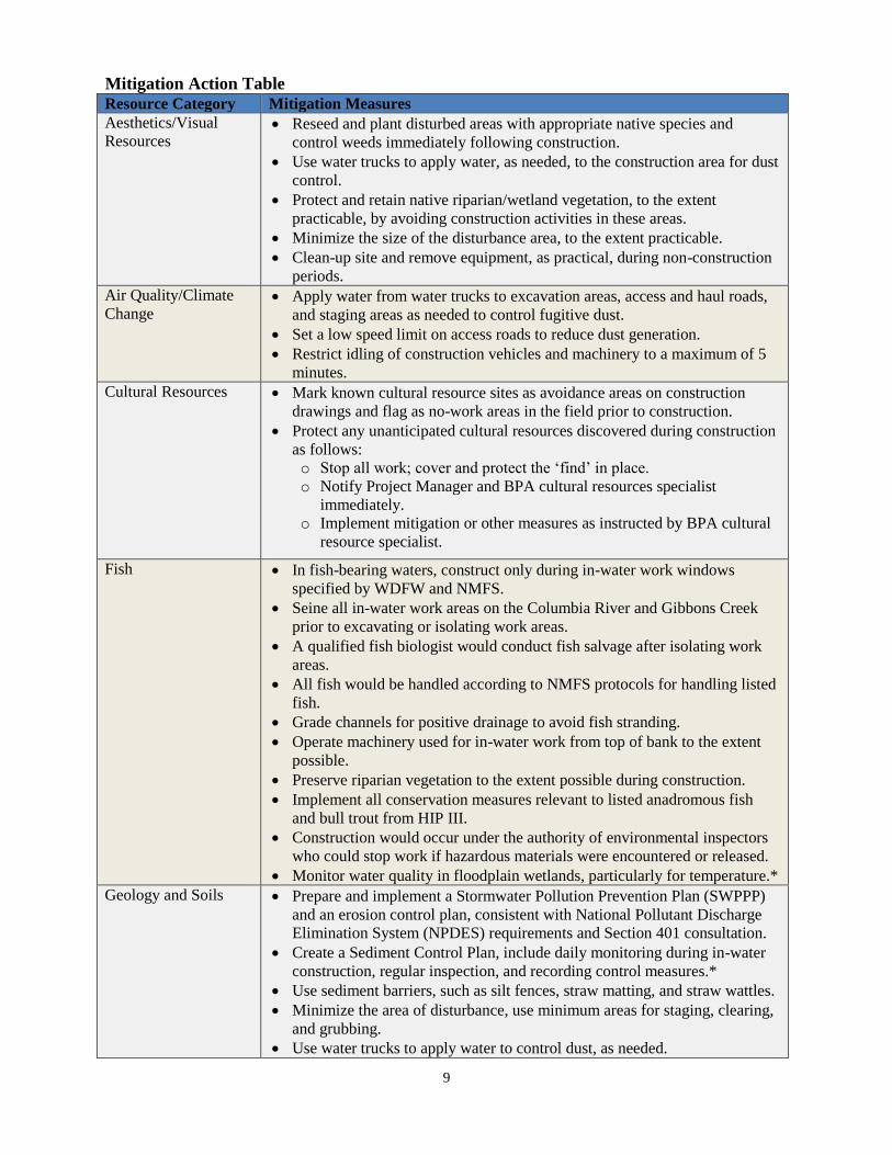
Mitigation Action Table
Resource Category Mitigation Measures
Aesthetics/Visual
Resources Reseed and plant disturbed areas with appropriate native species and
control weeds immediately following construction.
Use water trucks to apply water, as needed, to the construction area for dust
control.
Protect and retain native riparian/wetland vegetation, to the extent
practicable, by avoiding construction activities in these areas.
Minimize the size of the disturbance area, to the extent practicable.
Clean-up site and remove equipment, as practical, during non-construction
periods.
Air Quality/Climate
Change Apply water from water trucks to excavation areas, access and haul roads,
and staging areas as needed to control fugitive dust.
Set a low speed limit on access roads to reduce dust generation.
Restrict idling of construction vehicles and machinery to a maximum of 5
minutes.
Cultural Resources
Mark known cultural resource sites as avoidance areas on construction
drawings and flag as no-work areas in the field prior to construction.
Protect any unanticipated cultural resources discovered during construction
as follows:
o Stop all work; cover and protect the ‘find’ in place.
o Notify Project Manager and BPA cultural resources specialist
immediately.
o Implement mitigation or other measures as instructed by BPA cultural
resource specialist.
Fish In fish-bearing waters, construct only during in-water work windows
specified by WDFW and NMFS.
Seine all in-water work areas on the Columbia River and Gibbons Creek
prior to excavating or isolating work areas.
A qualified fish biologist would conduct fish salvage after isolating work
areas.
All fish would be handled according to NMFS protocols for handling listed
fish.
Grade channels for positive drainage to avoid fish stranding.
Operate machinery used for in-water work from top of bank to the extent
possible.
Preserve riparian vegetation to the extent possible during construction.
Implement all conservation measures relevant to listed anadromous fish
and bull trout from HIP III.
Construction would occur under the authority of environmental inspectors
who could stop work if hazardous materials were encountered or released.
Monitor water quality in floodplain wetlands, particularly for temperature.*
Geology and Soils Prepare and implement a Stormwater Pollution Prevention Plan (SWPPP)
and an erosion control plan, consistent with National Pollutant Discharge
Elimination System (NPDES) requirements and Section 401 consultation.
Create a Sediment Control Plan, include daily monitoring during in-water
construction, regular inspection, and recording control measures.*
Use sediment barriers, such as silt fences, straw matting, and straw wattles.
Minimize the area of disturbance, use minimum areas for staging, clearing,
and grubbing.
Use water trucks to apply water to control dust, as needed.
10
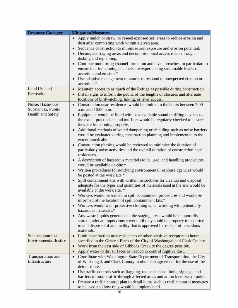
Resource Category Mitigation Measures
Apply mulch or straw, or reseed exposed soil areas to reduce erosion and
dust after completing work within a given area.
Sequence construction to minimize soil exposure and erosion potential.
Decompact staging areas and decommissioned access roads through
disking and replanting.
Continue monitoring channel formation and levee breaches, in particular, to
ensure that functioning channels are experiencing sustainable levels of
accretion and erosion.*
Use adaptive management measures to respond to unexpected erosion or
accretion.*
Land Use and
Recreation Maintain access to as much of the Refuge as possible during construction.
Install signs to inform the public of the lengths of closures and alternate
locations of birdwatching, hiking, or river access.
Noise, Hazardous
Substances, Public
Health and Safety
Construction near residences would be limited to the hours between 7:00
a.m. and 10:00 p.m.
Equipment would be fitted with best available sound muffling devices to
the extent practicable, and mufflers would be regularly checked to ensure
they are functioning properly.
Additional methods of sound dampening or shielding such as noise barriers
would be evaluated during construction planning and implemented to the
extent practicable.
Construction phasing would be reviewed to minimize the duration of
particularly noisy activities and the overall duration of construction near
residences.
A description of hazardous materials to be used, and handling procedures
would be available on-site.*
Written procedures for notifying environmental response agencies would
be posted at the work site.*
Spill containment kits with written instructions for cleanup and disposal
adequate for the types and quantities of materials used at the site would be
available at the work site. *
Workers would be trained in spill containment procedures and would be
informed of the location of spill containment kits.*
Workers would wear protective clothing when working with potentially
hazardous materials.*
Any waste liquids generated at the staging areas would be temporarily
stored under an impervious cover until they could be properly transported
to and disposed of at a facility that is approved for receipt of hazardous
materials.
Socioeconomics/
Environmental Justice Limit construction near residences or other sensitive receptors to hours
specified in the General Plans of the City of Washougal and Clark County.
Work from the east side of Gibbons Creek to the degree possible.
Apply water to dirt surfaces as needed to control fugitive dust.
Transportation and
Infrastructure Coordinate with Washington State Department of Transportation, the City
of Washougal, and Clark County to obtain an agreement for the use of the
detour route.
Use traffic controls such as flagging, reduced speed limits, signage, and
barriers to route traffic through affected areas and at truck entry/exit points.
Prepare a traffic control plan to detail items such as traffic control measures
to be used and how they would be implemented.
11
Resource Category Mitigation Measures
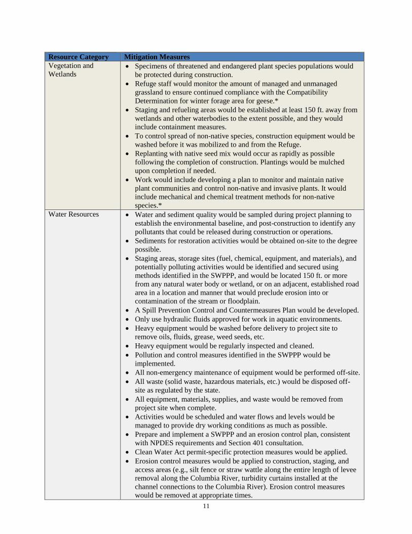
Vegetation and
Wetlands Specimens of threatened and endangered plant species populations would
be protected during construction.
Refuge staff would monitor the amount of managed and unmanaged
grassland to ensure continued compliance with the Compatibility
Determination for winter forage area for geese.*
Staging and refueling areas would be established at least 150 ft. away from
wetlands and other waterbodies to the extent possible, and they would
include containment measures.
To control spread of non-native species, construction equipment would be
washed before it was mobilized to and from the Refuge.
Replanting with native seed mix would occur as rapidly as possible
following the completion of construction. Plantings would be mulched
upon completion if needed.
Work would include developing a plan to monitor and maintain native
plant communities and control non-native and invasive plants. It would
include mechanical and chemical treatment methods for non-native
species.*
Water Resources Water and sediment quality would be sampled during project planning to
establish the environmental baseline, and post-construction to identify any
pollutants that could be released during construction or operations.
Sediments for restoration activities would be obtained on-site to the degree
possible.
Staging areas, storage sites (fuel, chemical, equipment, and materials), and
potentially polluting activities would be identified and secured using
methods identified in the SWPPP, and would be located 150 ft. or more
from any natural water body or wetland, or on an adjacent, established road
area in a location and manner that would preclude erosion into or
contamination of the stream or floodplain.
A Spill Prevention Control and Countermeasures Plan would be developed.
Only use hydraulic fluids approved for work in aquatic environments.
Heavy equipment would be washed before delivery to project site to
remove oils, fluids, grease, weed seeds, etc.
Heavy equipment would be regularly inspected and cleaned.
Pollution and control measures identified in the SWPPP would be
implemented.
All non-emergency maintenance of equipment would be performed off-site.
All waste (solid waste, hazardous materials, etc.) would be disposed off-
site as regulated by the state.
All equipment, materials, supplies, and waste would be removed from
project site when complete.
Activities would be scheduled and water flows and levels would be
managed to provide dry working conditions as much as possible.
Prepare and implement a SWPPP and an erosion control plan, consistent
with NPDES requirements and Section 401 consultation.
Clean Water Act permit-specific protection measures would be applied.
Erosion control measures would be applied to construction, staging, and
access areas (e.g., silt fence or straw wattle along the entire length of levee
removal along the Columbia River, turbidity curtains installed at the
channel connections to the Columbia River). Erosion control measures
would be removed at appropriate times.
12
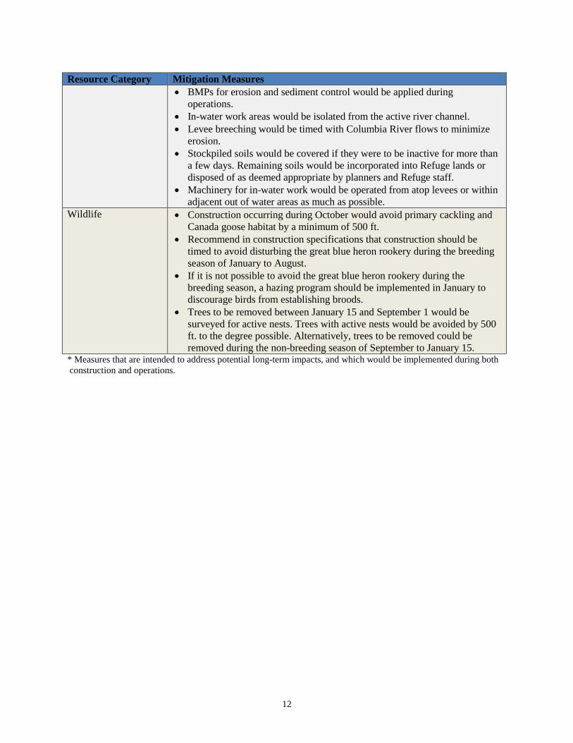
Resource Category Mitigation Measures
BMPs for erosion and sediment control would be applied during
operations.
In-water work areas would be isolated from the active river channel.
Levee breeching would be timed with Columbia River flows to minimize
erosion.
Stockpiled soils would be covered if they were to be inactive for more than
a few days. Remaining soils would be incorporated into Refuge lands or
disposed of as deemed appropriate by planners and Refuge staff.
Machinery for in-water work would be operated from atop levees or within
adjacent out of water areas as much as possible.
Wildlife Construction occurring during October would avoid primary cackling and
Canada goose habitat by a minimum of 500 ft.
Recommend in construction specifications that construction should be
timed to avoid disturbing the great blue heron rookery during the breeding
season of January to August.
If it is not possible to avoid the great blue heron rookery during the
breeding season, a hazing program should be implemented in January to
discourage birds from establishing broods.
Trees to be removed between January 15 and September 1 would be
surveyed for active nests. Trees with active nests would be avoided by 500
ft. to the degree possible. Alternatively, trees to be removed could be
removed during the non-breeding season of September to January 15. * Measures that are intended to address potential long-term impacts, and which would be implemented during both
construction and operations.
1 of 5
VER 03.13
B O N N E V I L L E P O W E R A D M I N I S T R A T I O N
HIP III
PROJECT NOTIFICATION FORM HIP III No: 2019008
Lead Action Agency: BPA
NMFS Tracking #:
2013/9724 Statutory Authority:
☒ ESA & EFH ☐ ESA
USFWS Tracking #: NA
Date of Request: 11/6/2018
Project Title: Steigerwald Floodplain Restoration Project
BPA Project #: 2003-011-00 Contract #: 77262
BPA EC Contact: Travis Kessler
Project Sponsor Contact: Chris Collins Phone: 503-226-1565 x235
Project Affiliation: Click here to enter text.
NMFS Branch Office: Washington Coast & Lower Columbia Branch - [email protected]
USFWS Field Office: NA
Lat/Long: (in decimal degrees, WGS84) 45.5646; -122.3000 County: CLARK, WA
6th
Field HUC: 170800010804; Latourell Creek-Columbia River
Project
Start Date: 4/1/2019
Project End
Date: 10/1/2019
Completed Form
Due Date: 10/30/2019
(Project Completion Form (PCF) and/or Herbicide Use Form (HUF) due ≤ 30-days after Project End Date)
Does the project consist of Surveys only?* Yes ☐ No☒
Does the project consist of Invasive Plant Control only?** Yes ☐ No☒
Does the project require work area isolation/fish salvage? Yes ☒ No☐
Does the project require a variance? Yes ☒ No☐
*(If project only consists of surveys then no PCF is necessary)
**(If project only consists of Invasive Plant Treatments then only a HUF is necessary)
RISK LEVEL
LOW
☐
MED
☐
HIGH
☒
2 of 5
VER 03.13
B O N N E V I L L E P O W E R A D M I N I S T R A T I O N
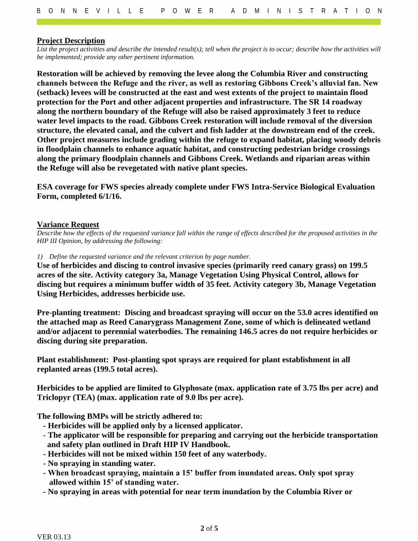
Project Description List the project activities and describe the intended result(s); tell when the project is to occur; describe how the activities will
be implemented; provide any other pertinent information.
Restoration will be achieved by removing the levee along the Columbia River and constructing
channels between the Refuge and the river, as well as restoring Gibbons Creek’s alluvial fan. New
(setback) levees will be constructed at the east and west extents of the project to maintain flood
protection for the Port and other adjacent properties and infrastructure. The SR 14 roadway
along the northern boundary of the Refuge will also be raised approximately 3 feet to reduce
water level impacts to the road. Gibbons Creek restoration will include removal of the diversion
structure, the elevated canal, and the culvert and fish ladder at the downstream end of the creek.
Other project measures include grading within the refuge to expand habitat, placing woody debris
in floodplain channels to enhance aquatic habitat, and constructing pedestrian bridge crossings
along the primary floodplain channels and Gibbons Creek. Wetlands and riparian areas within
the Refuge will also be revegetated with native plant species.
ESA coverage for FWS species already complete under FWS Intra-Service Biological Evaluation
Form, completed 6/1/16.
Variance Request Describe how the effects of the requested variance fall within the range of effects described for the proposed activities in the
HIP III Opinion, by addressing the following:
1) Define the requested variance and the relevant criterion by page number.
Use of herbicides and discing to control invasive species (primarily reed canary grass) on 199.5
acres of the site. Activity category 3a, Manage Vegetation Using Physical Control, allows for
discing but requires a minimum buffer width of 35 feet. Activity category 3b, Manage Vegetation
Using Herbicides, addresses herbicide use.
Pre-planting treatment: Discing and broadcast spraying will occur on the 53.0 acres identified on
the attached map as Reed Canarygrass Management Zone, some of which is delineated wetland
and/or adjacent to perennial waterbodies. The remaining 146.5 acres do not require herbicides or
discing during site preparation.
Plant establishment: Post-planting spot sprays are required for plant establishment in all
replanted areas (199.5 total acres).
Herbicides to be applied are limited to Glyphosate (max. application rate of 3.75 lbs per acre) and
Triclopyr (TEA) (max. application rate of 9.0 lbs per acre).
The following BMPs will be strictly adhered to:
- Herbicides will be applied only by a licensed applicator.
- The applicator will be responsible for preparing and carrying out the herbicide transportation
and safety plan outlined in Draft HIP IV Handbook.
- Herbicides will not be mixed within 150 feet of any waterbody.
- No spraying in standing water.
- When broadcast spraying, maintain a 15’ buffer from inundated areas. Only spot spray
allowed within 15’ of standing water.
- No spraying in areas with potential for near term inundation by the Columbia River or
3 of 5
VER 03.13
B O N N E V I L L E P O W E R A D M I N I S T R A T I O N
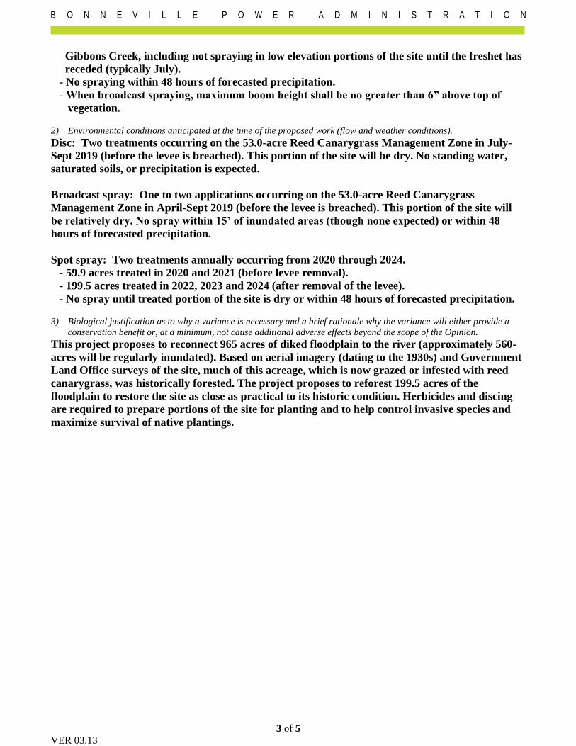
Gibbons Creek, including not spraying in low elevation portions of the site until the freshet has
receded (typically July).
- No spraying within 48 hours of forecasted precipitation.
- When broadcast spraying, maximum boom height shall be no greater than 6” above top of
vegetation.
2) Environmental conditions anticipated at the time of the proposed work (flow and weather conditions).
Disc: Two treatments occurring on the 53.0-acre Reed Canarygrass Management Zone in July-
Sept 2019 (before the levee is breached). This portion of the site will be dry. No standing water,
saturated soils, or precipitation is expected.
Broadcast spray: One to two applications occurring on the 53.0-acre Reed Canarygrass
Management Zone in April-Sept 2019 (before the levee is breached). This portion of the site will
be relatively dry. No spray within 15’ of inundated areas (though none expected) or within 48
hours of forecasted precipitation.
Spot spray: Two treatments annually occurring from 2020 through 2024.
- 59.9 acres treated in 2020 and 2021 (before levee removal).
- 199.5 acres treated in 2022, 2023 and 2024 (after removal of the levee).
- No spray until treated portion of the site is dry or within 48 hours of forecasted precipitation.
3) Biological justification as to why a variance is necessary and a brief rationale why the variance will either provide a
conservation benefit or, at a minimum, not cause additional adverse effects beyond the scope of the Opinion.
This project proposes to reconnect 965 acres of diked floodplain to the river (approximately 560-
acres will be regularly inundated). Based on aerial imagery (dating to the 1930s) and Government
Land Office surveys of the site, much of this acreage, which is now grazed or infested with reed
canarygrass, was historically forested. The project proposes to reforest 199.5 acres of the
floodplain to restore the site as close as practical to its historic condition. Herbicides and discing
are required to prepare portions of the site for planting and to help control invasive species and
maximize survival of native plantings.
4 of 5
VER 03.13
B O N N E V I L L E P O W E R A D M I N I S T R A T I O N
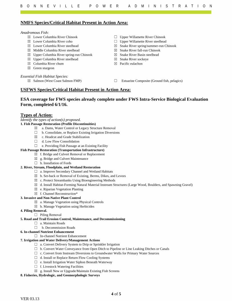
NMFS Species/Critical Habitat Present in Action Area:
Anadromous Fish: ☒ Lower Columbia River Chinook ☐ Upper Willamette River Chinook
☒ Lower Columbia River coho ☐ Upper Willamette River steelhead
☒ Lower Columbia River steelhead ☒ Snake River spring/summer-run Chinook
☒ Middle Columbia River steelhead ☒ Snake River fall-run Chinook
☒ Upper Columbia River spring-run Chinook ☒ Snake River Basin steelhead
☒ Upper Columbia River steelhead ☒ Snake River sockeye
☒ Columbia River chum ☒ Pacific eulachon
☒ Green sturgeon
Essential Fish Habitat Species: ☒ Salmon (West Coast Salmon FMP) ☐ Estuarine Composite (Ground fish, pelagics)
USFWS Species/Critical Habitat Present in Action Area:
ESA coverage for FWS species already complete under FWS Intra-Service Biological Evaluation
Form, completed 6/1/16.
Types of Action:
Identify the types of action(s) proposed. 1. Fish Passage Restoration (Profile Discontinuities)
☒ a. Dams, Water Control or Legacy Structure Removal
☐ b. Consolidate, or Replace Existing Irrigation Diversions
☒ c. Headcut and Grade Stabilization
☐ d. Low Flow Consolidation
☐ e. Providing Fish Passage at an Existing Facility
Fish Passage Restoration (Transportation Infrastructure)
☒ f. Bridge and Culvert Removal or Replacement
☒ g. Bridge and Culvert Maintenance
☐ h. Installation of Fords
2. River, Stream, Floodplain, and Wetland Restoration
☐ a. Improve Secondary Channel and Wetland Habitats
☒ b. Set-back or Removal of Existing, Berms, Dikes, and Levees
☒ c. Protect Streambanks Using Bioengineering Methods
☒ d. Install Habitat-Forming Natural Material Instream Structures (Large Wood, Boulders, and Spawning Gravel)
☒ e. Riparian Vegetation Planting
☒ f. Channel Reconstruction*
3. Invasive and Non-Native Plant Control
☒ a. Manage Vegetation using Physical Controls
☒ b. Manage Vegetation using Herbicides
4. Piling Removal.
☐ Piling Removal
5. Road and Trail Erosion Control, Maintenance, and Decommissioning
☐ a. Maintain Roads
☐ b. Decommission Roads
6. In-channel Nutrient Enhancement
☐ In-channel Nutrient Enhancement
7. Irrigation and Water Delivery/Management Actions
☐ a. Convert Delivery System to Drip or Sprinkler Irrigation
☐ b. Convert Water Conveyance from Open Ditch to Pipeline or Line Leaking Ditches or Canals
☐ c. Convert from Instream Diversions to Groundwater Wells for Primary Water Sources
☐ d. Install or Replace Return Flow Cooling Systems
☐ e. Install Irrigation Water Siphon Beneath Waterway
☐ f. Livestock Watering Facilities
☒ g. Install New or Upgrade/Maintain Existing Fish Screens
8. Fisheries, Hydrologic, and Geomorphologic Surveys
5 of 5
VER 03.13
B O N N E V I L L E P O W E R A D M I N I S T R A T I O N
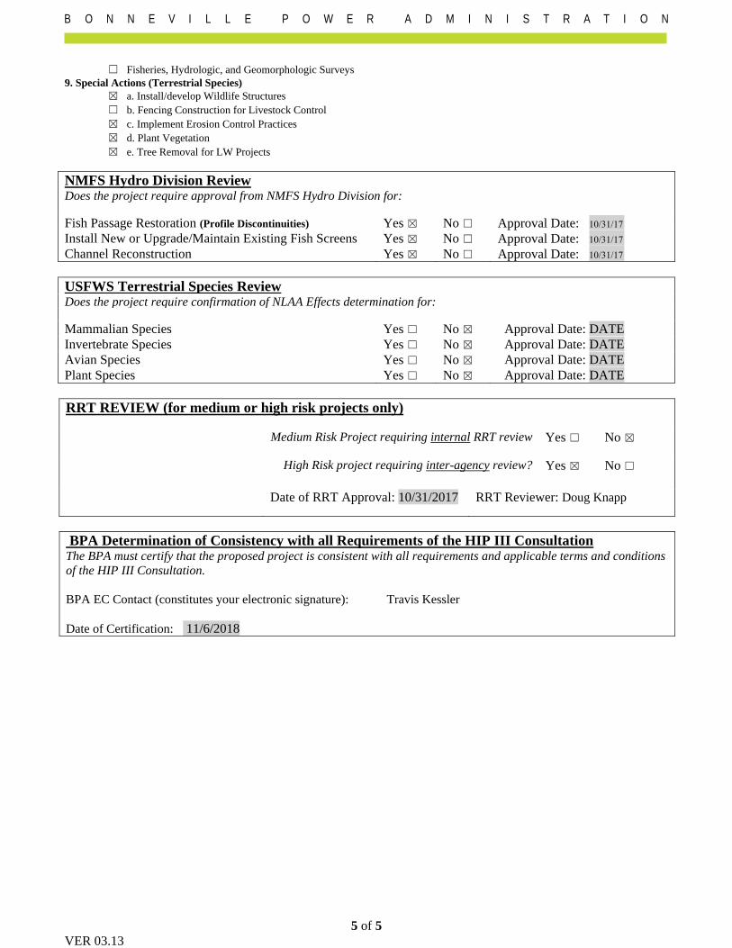
☐ Fisheries, Hydrologic, and Geomorphologic Surveys
9. Special Actions (Terrestrial Species)
☒ a. Install/develop Wildlife Structures
☐ b. Fencing Construction for Livestock Control
☒ c. Implement Erosion Control Practices
☒ d. Plant Vegetation
☒ e. Tree Removal for LW Projects
NMFS Hydro Division Review Does the project require approval from NMFS Hydro Division for:
Fish Passage Restoration (Profile Discontinuities) Yes ☒ No ☐
Install New or Upgrade/Maintain Existing Fish Screens Yes ☒ No ☐
Channel Reconstruction Yes ☒ No ☐
Approval Date: 10/31/17
Approval Date: 10/31/17
Approval Date: 10/31/17
USFWS Terrestrial Species Review Does the project require confirmation of NLAA Effects determination for:
Mammalian Species Yes ☐ No ☒ Approval Date: DATE
Invertebrate Species Yes ☐ No ☒ Approval Date: DATE
Avian Species Yes ☐ No ☒ Approval Date: DATE
Plant Species Yes ☐ No ☒ Approval Date: DATE
RRT REVIEW (for medium or high risk projects only)
Medium Risk Project requiring internal RRT review Yes ☐ No ☒
High Risk project requiring inter-agency review? Yes ☒ No ☐
Date of RRT Approval: 10/31/2017 RRT Reviewer: Doug Knapp
BPA Determination of Consistency with all Requirements of the HIP III Consultation The BPA must certify that the proposed project is consistent with all requirements and applicable terms and conditions
of the HIP III Consultation.
BPA EC Contact (constitutes your electronic signature): Travis Kessler
Date of Certification: 11/6/2018
From: Kessler,Travis D (CONTR) - ECF-4To: "Darlene Siegel"Subject: FW: [EXTERNAL] Re: Steigerwald Floodplain Restoration - Fish Passage ApprovalDate: Tuesday, February 19, 2019 10:53:46 AM
Hi Darlene, Please see the email below on October 31, 2017 from Jeff Brown that documents fish passageapproval. Thanks, Travis Kessler(CONTR) SalientCRGTEnvironmental Protection SpecialistBonneville Power AdministrationOffice: 503.230.5468Cell: [email protected] From: Scott Hecht - NOAA Federal [mailto:[email protected]] Sent: Tuesday, February 19, 2019 9:05 AMTo: Kessler,Travis D (CONTR) - ECF-4Cc: Jim B. Muck - NOAA Federal; Bonnie ShorinSubject: [EXTERNAL] Re: Steigerwald Floodplain Restoration - Fish Passage Approval Hi Travis-Please see the below email from Jeff and thanks Bonnie for your mining efforts. Jeff providedhis recommendation to grant a variance to the branch chief at the time (Bonnie). Scott On Tue, Oct 31, 2017 at 10:11 AM, Jeffrey Brown - NOAAFederal <[email protected]> wrote:Hi Bonnie and Doug, I have no problem with the setback including the flapgates provided they're set at the sameelevation and will provide no less inundation than was provided in the pre-project condition. This is a pretty good example of where a variance is appropriate, and the spirit of thedocument, vice the letter (the spirit being that HIP doesn't envision adding new flap gateswhere none previously existed) is being met, even if the letter may not be. As far a procedureunder HIP, the branch chief (is that you now, Bonnie?) will actually approve the variance. Myinput is a recommendation to that effect. Thanks for the opportunity to provide input. -Jeff
____________Jeff Brown P.E.Hydraulic Engineer
NOAA Fisheries ServicePortland, Oregon(503)230-5437
Scott Hecht, Ph.D.Branch Chief, Washington Coast-Lower ColumbiaNOAA Fisheries, West Coast Region Office: 360-534-9306Cell: 562-505-3441510 Desmond Drive SELacey, Washington98503 On Thu, Feb 14, 2019 at 11:17 AM Jim B. Muck - NOAA Federal <[email protected]>wrote:
Please check Scott Hect, Branch Chief of the Lower Columbia. Yes, I remember a projectwith Jeff Brown. Jim Jim B. MuckOregon Coast BranchOregon-Washington Coastal OfficeNational Marine Fisheries Service2900 NW Stewart ParkwayRoseburg, Oregon 97471
541-957-3394 Office [email protected]
On Tue, Feb 12, 2019 at 3:03 PM Kessler,Travis D (CONTR) - ECF-4<[email protected]> wrote:
Hi Jim, This is a follow up email to the voicemail I left you a bit ago. I am the EC Lead fromBPA finishing up with the Steigerwald Project and wanted to know if you had record ofthe fish passage approval from Jeff Brown from NOAA. I have an email from May 10th,2018 that you sent to Bonnie Shorin, but I need an actual email or some documentationfrom Jeff Brown that shows that he approved it with the date. Do you have anything thatshows approval? Thanks, Travis Kessler(CONTR) SalientCRGT

Environmental Protection SpecialistBonneville Power AdministrationOffice: 503.230.5468Cell: [email protected]


PERMITTEE AUTHORIZED AGENT OR CONTRACTOR
Lower Columbia Estuary Partnership Wolf Water Resources
ATTENTION: Debrah Marriott ATTENTION: Darlene Siegel
811 SW Naito Pkwy #410 1001 SE Water Ave, Ste 180
Portland, OR 97204 Portland, OR 97214
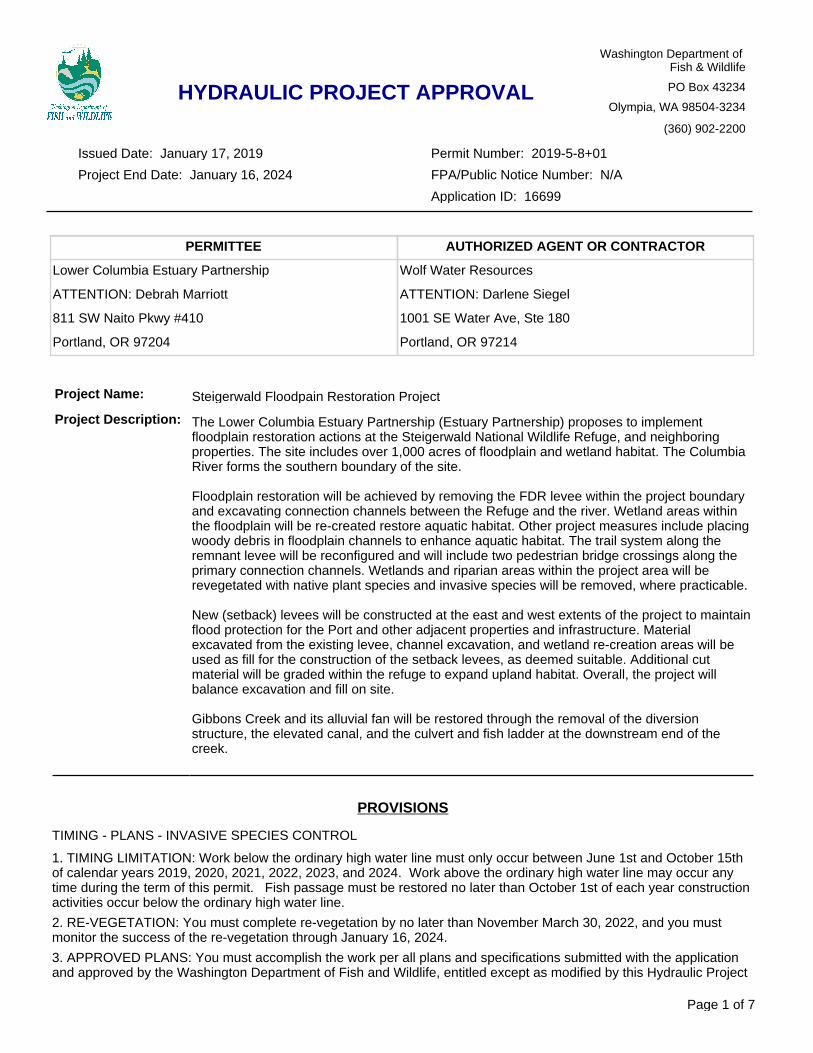
Project Name: Steigerwald Floodpain Restoration Project
Project Description: The Lower Columbia Estuary Partnership (Estuary Partnership) proposes to implement floodplain restoration actions at the Steigerwald National Wildlife Refuge, and neighboring properties. The site includes over 1,000 acres of floodplain and wetland habitat. The Columbia River forms the southern boundary of the site.
Floodplain restoration will be achieved by removing the FDR levee within the project boundary and excavating connection channels between the Refuge and the river. Wetland areas within the floodplain will be re-created restore aquatic habitat. Other project measures include placing woody debris in floodplain channels to enhance aquatic habitat. The trail system along the remnant levee will be reconfigured and will include two pedestrian bridge crossings along the primary connection channels. Wetlands and riparian areas within the project area will be revegetated with native plant species and invasive species will be removed, where practicable.
New (setback) levees will be constructed at the east and west extents of the project to maintain flood protection for the Port and other adjacent properties and infrastructure. Material excavated from the existing levee, channel excavation, and wetland re-creation areas will be used as fill for the construction of the setback levees, as deemed suitable. Additional cut material will be graded within the refuge to expand upland habitat. Overall, the project will balance excavation and fill on site.
Gibbons Creek and its alluvial fan will be restored through the removal of the diversion structure, the elevated canal, and the culvert and fish ladder at the downstream end of the creek.
PROVISIONS
TIMING - PLANS - INVASIVE SPECIES CONTROL
1. TIMING LIMITATION: Work below the ordinary high water line must only occur between June 1st and October 15th of calendar years 2019, 2020, 2021, 2022, 2023, and 2024. Work above the ordinary high water line may occur any time during the term of this permit. Fish passage must be restored no later than October 1st of each year construction activities occur below the ordinary high water line.
2. RE-VEGETATION: You must complete re-vegetation by no later than November March 30, 2022, and you must monitor the success of the re-vegetation through January 16, 2024.
3. APPROVED PLANS: You must accomplish the work per all plans and specifications submitted with the application and approved by the Washington Department of Fish and Wildlife, entitled except as modified by this Hydraulic Project
Page 1 of 7
HYDRAULIC PROJECT APPROVAL
Washington Department of Fish & Wildlife
PO Box 43234
Olympia, WA 98504-3234
(360) 902-2200
Permit Number: 2019-5-8+01
FPA/Public Notice Number: N/A
Application ID: 16699
Project End Date: January 16, 2024
Issued Date: January 17, 2019
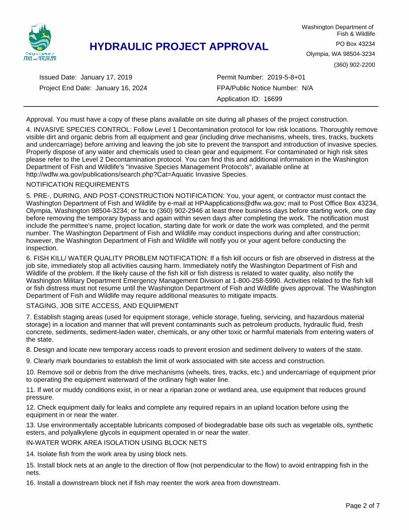
Approval. You must have a copy of these plans available on site during all phases of the project construction.
4. INVASIVE SPECIES CONTROL: Follow Level 1 Decontamination protocol for low risk locations. Thoroughly remove visible dirt and organic debris from all equipment and gear (including drive mechanisms, wheels, tires, tracks, buckets and undercarriage) before arriving and leaving the job site to prevent the transport and introduction of invasive species. Properly dispose of any water and chemicals used to clean gear and equipment. For contaminated or high risk sites please refer to the Level 2 Decontamination protocol. You can find this and additional information in the Washington Department of Fish and Wildlife's "Invasive Species Management Protocols", available online at http://wdfw.wa.gov/publications/search.php?Cat=Aquatic Invasive Species.
NOTIFICATION REQUIREMENTS
5. PRE-, DURING, AND POST-CONSTRUCTION NOTIFICATION: You, your agent, or contractor must contact the Washington Department of Fish and Wildlife by e-mail at [email protected]; mail to Post Office Box 43234, Olympia, Washington 98504-3234; or fax to (360) 902-2946 at least three business days before starting work, one day before removing the temporary bypass and again within seven days after completing the work. The notification must include the permittee's name, project location, starting date for work or date the work was completed, and the permit number. The Washington Department of Fish and Wildlife may conduct inspections during and after construction; however, the Washington Department of Fish and Wildlife will notify you or your agent before conducting the inspection.
6. FISH KILL/ WATER QUALITY PROBLEM NOTIFICATION: If a fish kill occurs or fish are observed in distress at the job site, immediately stop all activities causing harm. Immediately notify the Washington Department of Fish and Wildlife of the problem. If the likely cause of the fish kill or fish distress is related to water quality, also notify the Washington Military Department Emergency Management Division at 1-800-258-5990. Activities related to the fish kill or fish distress must not resume until the Washington Department of Fish and Wildlife gives approval. The Washington Department of Fish and Wildlife may require additional measures to mitigate impacts.
STAGING, JOB SITE ACCESS, AND EQUIPMENT
7. Establish staging areas (used for equipment storage, vehicle storage, fueling, servicing, and hazardous material storage) in a location and manner that will prevent contaminants such as petroleum products, hydraulic fluid, fresh concrete, sediments, sediment-laden water, chemicals, or any other toxic or harmful materials from entering waters of the state.
8. Design and locate new temporary access roads to prevent erosion and sediment delivery to waters of the state.
9. Clearly mark boundaries to establish the limit of work associated with site access and construction.
10. Remove soil or debris from the drive mechanisms (wheels, tires, tracks, etc.) and undercarriage of equipment prior to operating the equipment waterward of the ordinary high water line.
11. If wet or muddy conditions exist, in or near a riparian zone or wetland area, use equipment that reduces ground pressure.
12. Check equipment daily for leaks and complete any required repairs in an upland location before using the equipment in or near the water.
13. Use environmentally acceptable lubricants composed of biodegradable base oils such as vegetable oils, synthetic esters, and polyalkylene glycols in equipment operated in or near the water.
IN-WATER WORK AREA ISOLATION USING BLOCK NETS
14. Isolate fish from the work area by using block nets.
15. Install block nets at an angle to the direction of flow (not perpendicular to the flow) to avoid entrapping fish in the nets.
16. Install a downstream block net if fish may reenter the work area from downstream.
Page 2 of 7
HYDRAULIC PROJECT APPROVAL
Washington Department of Fish & Wildlife
PO Box 43234
Olympia, WA 98504-3234
(360) 902-2200
Permit Number: 2019-5-8+01
FPA/Public Notice Number: N/A
Application ID: 16699
Project End Date: January 16, 2024
Issued Date: January 17, 2019
17. To anchor block nets, place bags filled with clean round gravel along the bottom of the nets.
18. Secure block nets along both banks and the channel bottom to prevent failure from debris accumulation, high flows, and/or flanking.
19. To keep fish out of the job site, leave block nets in place until the work is complete and conditions are suitable for fish.
IN-WATER WORK AREA ISOLATION USING A COFFERDAM STRUCTURE
20. Use a cofferdam, dike, or similar structure to exclude water from the work area.
21. Maintain water quality when installing and removing the cofferdam, dike or similar structure.
22. Install the cofferdam, dike or similar structure and remove fish prior to the start of other work in the wetted perimeter.
23. Sequence the work to minimize the duration of dewatering.
FISH LIFE REMOVAL
24. All persons participating in capture and removal must have training, knowledge, and skills in the safe handling of fish life.
25. A person with electrofishing training must be on-site to conduct or direct all electrofishing activities.
26. If personnel are available, the Washington Department of Fish and Wildlife and affected tribes may help capture and move fish life from the job site.
27. Place block nets upstream and downstream of the in-water work area before capturing and removing fish life.
28. Capture and safely move fish life from the work area to the nearest suitable free-flowing water.
29. All persons removing fish life from a job site must follow the protocol outlined on Sheet G1.4 of the design set submitted with the application.
30. Detailed protocol for the salvage of lamprey ammocoetes will be submitted to the WDFW for approval before construction operations begin.
CHANNEL RELOCATION AND REALIGNMENT
31. During construction, isolate the new channel from the flowing watercourse.
32. Before water is diverted into a permanent new channel(s), install approved habitat components and bed and bank protection materials to prevent erosion as shown in the approved plan.
33. Use fir, cedar, or other coniferous species (except as noted in the plans) to construct log or rootwad fish habitat structure(s).
34. Place the fish habitat structures in the low flow channel.
35. Size streambed material to mimic the gradation found in nearby reference channel reaches. The material must be well-graded (includes all size classes), non-porous, with 5-10% fines with sieve size U.S. No. 200 to prevent subsurface flow. Create a low-flow channel and a high-flow bench on both sides of the channel. Angular rock is not permitted within the channel.
36. The Habitat Biologist listed below or their representative must inspect and approve the new channel before the stream is diverted into the channel.
37. Diverting the flow into the new channel: a. First remove the downstream plug. b. Face the stream side of the plug with a sandbag or similar device. c. Partially remove the upstream plug to allow 1/3 to 1/2 of the flow into the new channel for a minimum of 10 hours.
Page 3 of 7
HYDRAULIC PROJECT APPROVAL
Washington Department of Fish & Wildlife
PO Box 43234
Olympia, WA 98504-3234
(360) 902-2200
Permit Number: 2019-5-8+01
FPA/Public Notice Number: N/A
Application ID: 16699
Project End Date: January 16, 2024
Issued Date: January 17, 2019
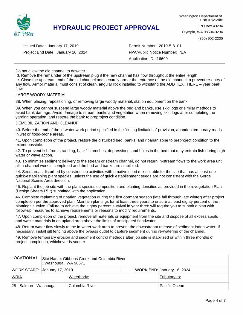
LOCATION #1: Site Name: Gibbons Creek and Columbia River, Washougal, WA 98671
WORK START: January 17, 2019 WORK END: January 16, 2024
WRIA Waterbody: Tributary to:
28 - Salmon - Washougal Columbia River Pacific Ocean
Do not allow the old channel to dewater. d. Remove the remainder of the upstream plug if the new channel has flow throughout the entire length. e. Close the upstream end of the old channel and securely armor the entrance of the old channel to prevent re-entry of any flow. Armor material must consist of clean, angular rock installed to withstand the ADD TEXT HERE – year peak flow.
LARGE WOODY MATERIAL
38. When placing, repositioning, or removing large woody material, station equipment on the bank.
39. When you cannot suspend large woody material above the bed and banks, use skid logs or similar methods to avoid bank damage. Avoid damage to stream banks and vegetation when removing skid logs after completing the yarding operation, and restore the bank to preproject condition.
DEMOBILIZATION AND CLEANUP
40. Before the end of the in-water work period specified in the “timing limitations” provision, abandon temporary roads in wet or flood-prone areas.
41. Upon completion of the project, restore the disturbed bed, banks, and riparian zone to preproject condition to the extent possible.
42. To prevent fish from stranding, backfill trenches, depressions, and holes in the bed that may entrain fish during high water or wave action.
43. To minimize sediment delivery to the stream or stream channel, do not return in-stream flows to the work area until all in-channel work is completed and the bed and banks are stabilized.
44. Seed areas disturbed by construction activities with a native seed mix suitable for the site that has at least one quick-establishing plant species, unless the use of quick establishment seeds are not consistent with the Gorge National Scenic Area direction.
45. Replant the job site with the plant species composition and planting densities as provided in the revegetation Plan (Design Sheets L5.*) submitted with the application.
46. Complete replanting of riparian vegetation during the first dormant season (late fall through late winter) after project completion per the approved plan. Maintain plantings for at least three years to ensure at least eighty percent of the plantings survive. Failure to achieve the eighty percent survival in year three will require you to submit a plan with follow-up measures to achieve requirements or reasons to modify requirements.
47. Upon completion of the project, remove all materials or equipment from the site and dispose of all excess spoils and waste materials in an upland area above the limits of anticipated floodwater.
48. Return water flow slowly to the in-water work area to prevent the downstream release of sediment laden water. If necessary, install silt fencing above the bypass outlet to capture sediment during re-watering of the channel.
49. Remove temporary erosion and sediment control methods after job site is stabilized or within three months of project completion, whichever is sooner.
Page 4 of 7
HYDRAULIC PROJECT APPROVAL
Washington Department of Fish & Wildlife
PO Box 43234
Olympia, WA 98504-3234
(360) 902-2200
Permit Number: 2019-5-8+01
FPA/Public Notice Number: N/A
Application ID: 16699
Project End Date: January 16, 2024
Issued Date: January 17, 2019
APPLY TO ALL HYDRAULIC PROJECT APPROVALS
This Hydraulic Project Approval pertains only to those requirements of the Washington State Hydraulic Code, specifically Chapter 77.55 RCW. Additional authorization from other public agencies may be necessary for this project. The person(s) to whom this Hydraulic Project Approval is issued is responsible for applying for and obtaining any additional authorization from other public agencies (local, state and/or federal) that may be necessary for this project.
This Hydraulic Project Approval shall be available on the job site at all times and all its provisions followed by the person(s) to whom this Hydraulic Project Approval is issued and operator(s) performing the work.
This Hydraulic Project Approval does not authorize trespass.
The person(s) to whom this Hydraulic Project Approval is issued and operator(s) performing the work may be held liable for any loss or damage to fish life or fish habitat that results from failure to comply with the provisions of this Hydraulic Project Approval.
Failure to comply with the provisions of this Hydraulic Project Approval could result in a civil penalty of up to one hundred dollars per day and/or a gross misdemeanor charge, possibly punishable by fine and/or imprisonment.
All Hydraulic Project Approvals issued under RCW 77.55.021 are subject to additional restrictions, conditions, or revocation if the Department of Fish and Wildlife determines that changed conditions require such action. The person(s) to whom this Hydraulic Project Approval is issued has the right to appeal those decisions. Procedures for filing appeals are listed below.
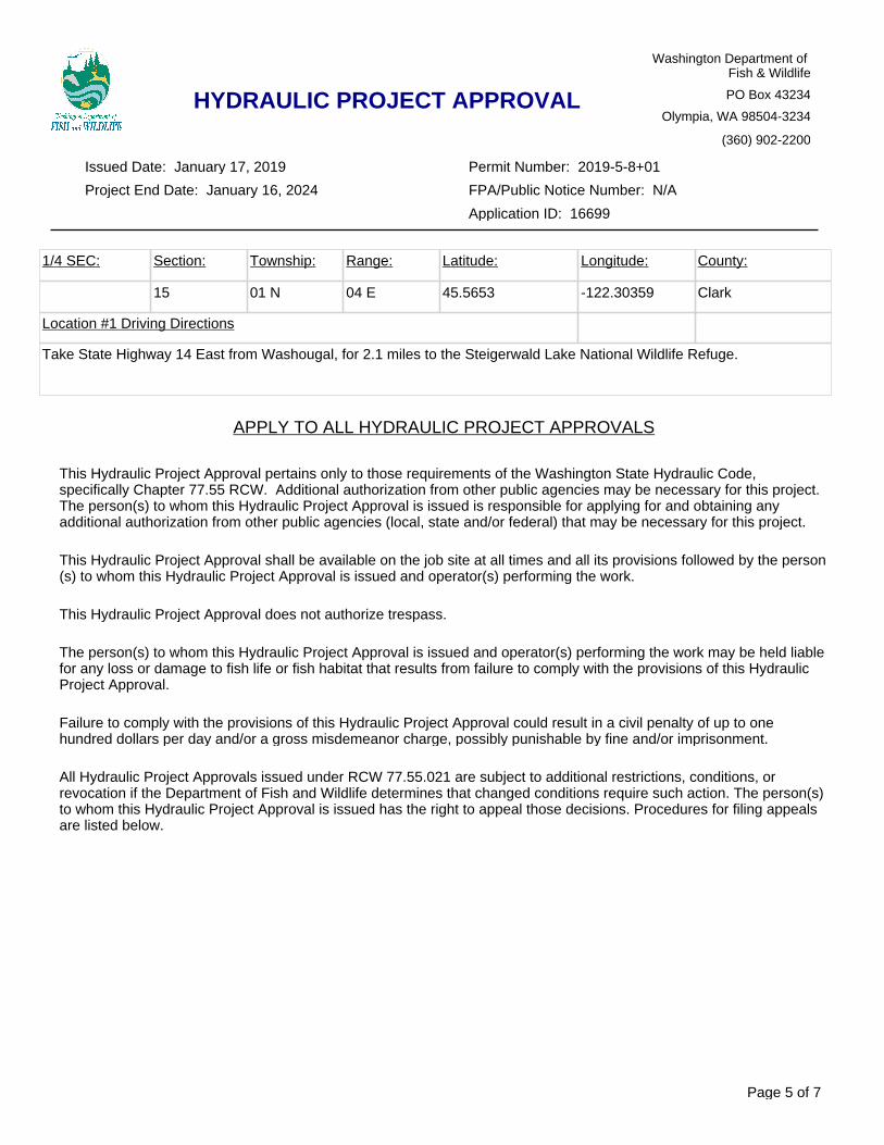
1/4 SEC: Section: Township: Range: Latitude: Longitude: County:
15 01 N 04 E 45.5653 -122.30359 Clark
Location #1 Driving Directions
Take State Highway 14 East from Washougal, for 2.1 miles to the Steigerwald Lake National Wildlife Refuge.
Page 5 of 7
HYDRAULIC PROJECT APPROVAL
Washington Department of Fish & Wildlife
PO Box 43234
Olympia, WA 98504-3234
(360) 902-2200
Permit Number: 2019-5-8+01
FPA/Public Notice Number: N/A
Application ID: 16699
Project End Date: January 16, 2024
Issued Date: January 17, 2019
MINOR MODIFICATIONS TO THIS HPA: You may request approval of minor modifications to the required work timing or to the plans and specifications approved in this HPA unless this is a General HPA. If this is a General HPA you must use the Major Modification process described below. Any approved minor modification will require issuance of a letter documenting the approval. A minor modification to the required work timing means any change to the work start or end dates of the current work season to enable project or work phase completion. Minor modifications will be approved only if spawning or incubating fish are not present within the vicinity of the project. You may request subsequent minor modifications to the required work timing. A minor modification of the plans and specifications means any changes in the materials, characteristics or construction of your project that does not alter the project's impact to fish life or habitat and does not require a change in the provisions of the HPA to mitigate the impacts of the modification. If you originally applied for your HPA through the online Aquatic Protection Permitting System (APPS), you may request a minor modification through APPS. A link to APPS is at http://wdfw.wa.gov/licensing/hpa/. If you did not use APPS you must submit a written request that clearly indicates you are seeking a minor modification to an existing HPA. Written requests must include the name of the applicant, the name of the authorized agent if one is acting for the applicant, the APP ID number of the HPA, the date issued, the permitting biologist, the requested changes to the HPA, the reason for the requested change, the date of the request, and the requestor's signature. Send by mail to: Washington Department of Fish and Wildlife, PO Box 43234, Olympia, Washington 98504-3234, or by email to [email protected]. You should allow up to 45 days for the department to process your request.
MAJOR MODIFICATIONS TO THIS HPA: You may request approval of major modifications to any aspect of your HPA. Any approved change other than a minor modification to your HPA will require issuance of a new HPA. If you originally applied for your HPA through the online Aquatic Protection Permitting System (APPS), you may request a major modification through APPS. A link to APPS is at http://wdfw.wa.gov/licensing/hpa/. If you did not use APPS you must submit a written request that clearly indicates you are requesting a major modification to an existing HPA. Written requests must include the name of the applicant, the name of the authorized agent if one is acting for the applicant, the APP ID number of the HPA, the date issued, the permitting biologist, the requested changes to the HPA, the reason for the requested change, the date of the request, and the requestor's signature. Send your written request by mail to: Washington Department of Fish and Wildlife, PO Box 43234, Olympia, Washington 98504-3234. You may email your request for a major modification to [email protected]. You should allow up to 45 days for the department to process your request.
APPEALS INFORMATION
If you wish to appeal the issuance, denial, conditioning, or modification of a Hydraulic Project Approval (HPA), Washington Department of Fish and Wildlife (WDFW) recommends that you first contact the department employee who issued or denied the HPA to discuss your concerns. Such a discussion may resolve your concerns without the need for further appeal action. If you proceed with an appeal, you may request an informal or formal appeal. WDFW encourages you to take advantage of the informal appeal process before initiating a formal appeal. The informal appeal process includes a review by department management of the HPA or denial and often resolves issues faster and with less legal complexity than the formal appeal process. If the informal appeal process does not resolve your concerns, you may advance your appeal to the formal process. You may contact the HPA Appeals Coordinator at (360) 902-2534 for more information.
A. INFORMAL APPEALS: WAC 220-660-460 is the rule describing how to request an informal appeal of WDFW actions taken under Chapter 77.55 RCW. Please refer to that rule for complete informal appeal procedures. The following information summarizes that rule.
Page 6 of 7
HYDRAULIC PROJECT APPROVAL
Washington Department of Fish & Wildlife
PO Box 43234
Olympia, WA 98504-3234
(360) 902-2200
Permit Number: 2019-5-8+01
FPA/Public Notice Number: N/A
Application ID: 16699
Project End Date: January 16, 2024
Issued Date: January 17, 2019
A person who is aggrieved by the issuance, denial, conditioning, or modification of an HPA may request an informal appeal of that action. You must send your request to WDFW by mail to the HPA Appeals Coordinator, Department of Fish and Wildlife, Habitat Program, PO Box 43234, Olympia, Washington 98504-3234; e-mail to [email protected]; fax to (360) 902-2946; or hand-delivery to the Natural Resources Building, 1111 Washington St SE, Habitat Program, Fifth floor. WDFW must receive your request within 30 days from the date you receive notice of the decision. If you agree, and you applied for the HPA, resolution of the appeal may be facilitated through an informal conference with the WDFW employee responsible for the decision and a supervisor. If a resolution is not reached through the informal conference, or you are not the person who applied for the HPA, the HPA Appeals Coordinator or designee may conduct an informal hearing or review and recommend a decision to the Director or designee. If you are not satisfied with the results of the informal appeal, you may file a request for a formal appeal.
B. FORMAL APPEALS: WAC 220-660-470 is the rule describing how to request a formal appeal of WDFW actions taken under Chapter 77.55 RCW. Please refer to that rule for complete formal appeal procedures. The following information summarizes that rule.
A person who is aggrieved by the issuance, denial, conditioning, or modification of an HPA may request a formal appeal of that action. You must send your request for a formal appeal to the clerk of the Pollution Control Hearings Boards and serve a copy on WDFW within 30 days from the date you receive notice of the decision. You may serve WDFW by mail to the HPA Appeals Coordinator, Department of Fish and Wildlife, Habitat Program, PO Box 43234, Olympia, Washington 98504-3234; e-mail to [email protected]; fax to (360) 902-2946; or hand-delivery to the Natural Resources Building, 1111 Washington St SE, Habitat Program, Fifth floor. The time period for requesting a formal appeal is suspended during consideration of a timely informal appeal. If there has been an informal appeal, you may request a formal appeal within 30 days from the date you receive the Director's or designee's written decision in response to the informal appeal.
C. FAILURE TO APPEAL WITHIN THE REQUIRED TIME PERIODS: If there is no timely request for an appeal, the WDFW action shall be final and unappealable.
Habitat Biologist [email protected]
for Director
WDFWChuck Stambaugh-Bowey
360-906-6764
Page 7 of 7
HYDRAULIC PROJECT APPROVAL
Washington Department of Fish & Wildlife
PO Box 43234
Olympia, WA 98504-3234
(360) 902-2200
Permit Number: 2019-5-8+01
FPA/Public Notice Number: N/A
Application ID: 16699
Project End Date: January 16, 2024
Issued Date: January 17, 2019