Evidence of flexural extension of the Rif foreland : The Rharb ...
6
Evidence of flexural extension of the Rif foreland : The Rharb-Mamora basin (northern Morocco) LAHCEN ZOUHRI 1 ,CHRISTIAN LAMOUROUX 2 ,DANIEL VACHARD 3 and ALAIN PIQUE 4 Key words. – Prerifean, Nappe, Blind thrust, K2SF, Flexural, Morocco. Abstract. – The Rharb-Mamora basin is the foreland of the Rif Cordillera (orogenic belt). The Mamora area (northern Morocco) is located at the southern border of the Rharb basin and intercalated between the Alpine Rif Mountains to the north and the Hercynian Moroccan Meseta domain to the south. Analysis and interpretation of seismic lines, hydrogeological and oil wells, have allowed to precise the major structural elements of the Mamora area, which is covered by late Neogene sediments. The structure of the area is controlled by faults that also affect the Paleozoic basement. The NE-SW and NW-SE trending faults induce the palaeogeographical evolution and control, the facies distribution and the thickness variations. The most important or relevant structural feature of the Mamora area is the Kenitra-Sidi-Slimane fault (K2SF) [Zouhri et al., 2001]. This fault N110 o E trending is south of the Rif Alpine thrust front and is marked by a progressive deepen- ing of its northern compartment, at least since Cretaceous time. Thus the Mamora appears as a hinge between the Rharb Basin and the Moroccan Meseta from Cretaceous to Neogene time. Preuves d’extensions flexurales dans l’avant-pays rifain : le bassin du Rharb-Mamora (Nord Maroc) Mots clés. – Nappe Pré-Rifaine, Chevauchement aveugle, FK2S, Flexure, Maroc. Résumé. – Le bassin du Rharb représente l’avant-pays de la Cordillère du Rif. La Mamora (nord du Maroc) correspond à la bordure méridionale de ce bassin entre les nappes pré-rifaines alpines au nord et la Meseta hercynienne au sud. La Mamora, largement couverte par des formations actuelles, l’analyse du potentiel des ressources naturelles, leur exploitation et leur gestion cohérente nécessitent une bonne connaissance des diverses formations et de leurs structures. L’analyse et l’interprétation de profils sismiques, de forages hydrogéologiques et pétroliers ont permis de préciser les structures majeures de la Mamora, largement recouvertes par des sédiments néogènes. La structure de cette région est contrôlée par des failles au moins hercyniennes, bien connues dans le substratum paléozoïque. Les deux grandes familles, NE-SW et NW-SE, ont contrôlé l’évolution paléogéographique (répartition des faciès et variations de la puissance des formations). La faille majeure dans cette région est la faille Kénitra – Sidi-Sli- mane (FK2S) [Zouhri et al., 2001]. Cette faille N110 o E, à fort pendage N, est localisée au S du front de la nappe pré-ri- faine dont l’amortissement est aveugle. Elle se traduit par un effondrement progressif vers le N. Il pourrait s’agir d’une réplique de la faille Rabat – Tiflet. La Mamora apparaît ainsi comme une charnière entre le Rharb subsident et la Meseta marocaine stable depuis le Mésozoïque. INTRODUCTION The northwestern corner of Africa is characterized by the presence of an Alpine belt named Rif belt in Morocco, which developed during Mesozoic and Tertiary times as a result of the convergence of African and European plates more and less at the same time that the development of the Mediterrranean sea [Fernandez et al., 1998 ; Frizon de Lamotte et al., 2000 ; Chalouan et al., 2001 ; Michard et al., 2002]. In Morocco, during the latest stages of the Rifean compression, i.e. the Tortonian, Messinian, the Al- pine foreland was located in the Rharb zone (fig. 1), along the front of the south-vergent Rif nappes [Feinberg, 1978 ; Faugères, 1978, 1981 ; Cirac, 1990 ; Flinch, 1993]. The Mamora, located south of the Rharb Basin and north of the Hercynian Moroccan Meseta [Piqué and Michard, 1989], is a very flat plain, almost everywhere cov- ered by Quaternary fluvial-alluvial deposits. Its structure can only be studied by subsurface data (seismic and wells). The aim of the present paper is to determine its structure, principally from the study of seismic profiles, hydrogeological and oil wells, in order to discuss the structural evolution of the outermost part of the Rharb foreland basin and to permit a Bull. Soc. géol. Fr., 2002, t. 173, n o 6, pp. 509-514 Bull. Soc. géol. Fr., 2002, n o 6 1 Centre de Calcul et de Modélisation de Lens, Faculté des Sciences Jean Perrin, Université d’Artois, Rue Jean Souvras, BP 18, 62307 Lens cedex (France). e-mail:[email protected] 2 Laboratoire de Sédimentologie et Dynamique, Université des Sciences et Technologies de Lille, Bât. SN5, 59655 Villeneuve d’Ascq cedex (France). 3 Laboratoire de Paléontologie, UPRESA 8014 du CNRS. Université des Sciences et Technologies de Lille, Bât. SN5, 59655 Villeneuve d’Ascq cedex (France). 4 Institut Universitaire Européen de la Mer, UMR 6538, Place Copernic, 29280 Plouzané (France). Manuscrit déposé le 3 octobre 2001 ; accepté après révision le 7 mai 2002.
Transcript of Evidence of flexural extension of the Rif foreland : The Rharb ...
Evidence of flexural extension of the Rif foreland : The Rharb-Mamora basin(northern Morocco)
LAHCEN ZOUHRI1, CHRISTIAN LAMOUROUX2, DANIEL VACHARD3 and ALAIN PIQUE4
Key words. – Prerifean, Nappe, Blind thrust, K2SF, Flexural, Morocco.
Abstract. – The Rharb-Mamora basin is the foreland of the Rif Cordillera (orogenic belt). The Mamora area (northernMorocco) is located at the southern border of the Rharb basin and intercalated between the Alpine Rif Mountains to thenorth and the Hercynian Moroccan Meseta domain to the south.
Analysis and interpretation of seismic lines, hydrogeological and oil wells, have allowed to precise the majorstructural elements of the Mamora area, which is covered by late Neogene sediments.
The structure of the area is controlled by faults that also affect the Paleozoic basement. The NE-SW and NW-SEtrending faults induce the palaeogeographical evolution and control, the facies distribution and the thickness variations.The most important or relevant structural feature of the Mamora area is the Kenitra-Sidi-Slimane fault (K2SF) [Zouhriet al., 2001]. This fault N110oE trending is south of the Rif Alpine thrust front and is marked by a progressive deepen-ing of its northern compartment, at least since Cretaceous time. Thus the Mamora appears as a hinge between the RharbBasin and the Moroccan Meseta from Cretaceous to Neogene time.
Preuves d’extensions flexurales dans l’avant-pays rifain : le bassin du Rharb-Mamora(Nord Maroc)
Mots clés. – Nappe Pré-Rifaine, Chevauchement aveugle, FK2S, Flexure, Maroc.
Résumé. – Le bassin du Rharb représente l’avant-pays de la Cordillère du Rif. La Mamora (nord du Maroc) correspond àla bordure méridionale de ce bassin entre les nappes pré-rifaines alpines au nord et la Meseta hercynienne au sud.
La Mamora, largement couverte par des formations actuelles, l’analyse du potentiel des ressources naturelles, leurexploitation et leur gestion cohérente nécessitent une bonne connaissance des diverses formations et de leurs structures.
L’analyse et l’interprétation de profils sismiques, de forages hydrogéologiques et pétroliers ont permis de préciserles structures majeures de la Mamora, largement recouvertes par des sédiments néogènes.
La structure de cette région est contrôlée par des failles au moins hercyniennes, bien connues dans le substratumpaléozoïque. Les deux grandes familles, NE-SW et NW-SE, ont contrôlé l’évolution paléogéographique (répartition desfaciès et variations de la puissance des formations). La faille majeure dans cette région est la faille Kénitra – Sidi-Sli-mane (FK2S) [Zouhri et al., 2001]. Cette faille N110oE, à fort pendage N, est localisée au S du front de la nappe pré-ri-faine dont l’amortissement est aveugle. Elle se traduit par un effondrement progressif vers le N. Il pourrait s’agir d’uneréplique de la faille Rabat – Tiflet. La Mamora apparaît ainsi comme une charnière entre le Rharb subsident et la Mesetamarocaine stable depuis le Mésozoïque.
INTRODUCTION
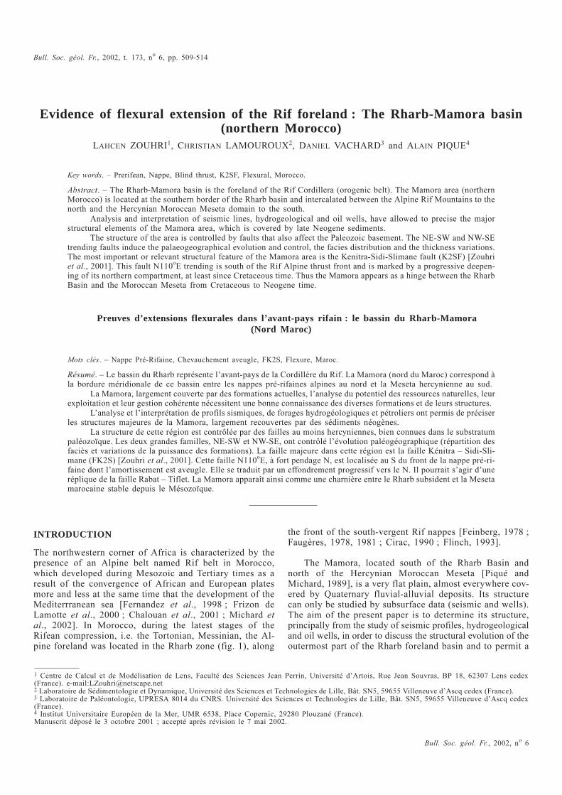
The northwestern corner of Africa is characterized by thepresence of an Alpine belt named Rif belt in Morocco,which developed during Mesozoic and Tertiary times as aresult of the convergence of African and European platesmore and less at the same time that the development of theMediterrranean sea [Fernandez et al., 1998 ; Frizon deLamotte et al., 2000 ; Chalouan et al., 2001 ; Michard etal., 2002]. In Morocco, during the latest stages of theRifean compression, i.e. the Tortonian, Messinian, the Al-pine foreland was located in the Rharb zone (fig. 1), along
the front of the south-vergent Rif nappes [Feinberg, 1978 ;Faugères, 1978, 1981 ; Cirac, 1990 ; Flinch, 1993].
The Mamora, located south of the Rharb Basin andnorth of the Hercynian Moroccan Meseta [Piqué andMichard, 1989], is a very flat plain, almost everywhere cov-ered by Quaternary fluvial-alluvial deposits. Its structurecan only be studied by subsurface data (seismic and wells).The aim of the present paper is to determine its structure,principally from the study of seismic profiles, hydrogeologicaland oil wells, in order to discuss the structural evolution of theoutermost part of the Rharb foreland basin and to permit a
Bull. Soc. géol. Fr., 2002, t. 173, no 6, pp. 509-514
Bull. Soc. géol. Fr., 2002, no 6
1 Centre de Calcul et de Modélisation de Lens, Faculté des Sciences Jean Perrin, Université d’Artois, Rue Jean Souvras, BP 18, 62307 Lens cedex(France). e-mail:[email protected] Laboratoire de Sédimentologie et Dynamique, Université des Sciences et Technologies de Lille, Bât. SN5, 59655 Villeneuve d’Ascq cedex (France).3 Laboratoire de Paléontologie, UPRESA 8014 du CNRS. Université des Sciences et Technologies de Lille, Bât. SN5, 59655 Villeneuve d’Ascq cedex(France).4 Institut Universitaire Européen de la Mer, UMR 6538, Place Copernic, 29280 Plouzané (France).Manuscrit déposé le 3 octobre 2001 ; accepté après révision le 7 mai 2002.
subsequent evaluation of its potentialities as a water reser-voir.
THE MAMORA ZONE : SEDIMENTARY ANDREGIONAL SETTING
The Mamora basement crops out at Tiflet (fig. 1). It con-sists of Cambrian sedimentary sequences deformed prior tothe emplacement of granitoids dated as old as 430 ± 2 Ma[Piqué, 1982]. The folds and thrusts exhibit WNW-ESEtrends and a south vergence. The rocks have been subse-quently refolded during the Hercynian orogeny and affectedby the N110oE right-lateral Rabat-Tiflet fault.
The Morrocan Meseta is overlain by Upper Triassic andlowermost Liassic shales and evaporitic formations [Lavilleand Piqué, 1991]. These basins are trending N020-040oE di-rection in the western part [Burger et al., 1960-1962] andN080oE in the eastern part of northern Meseta [Salvan,1974].
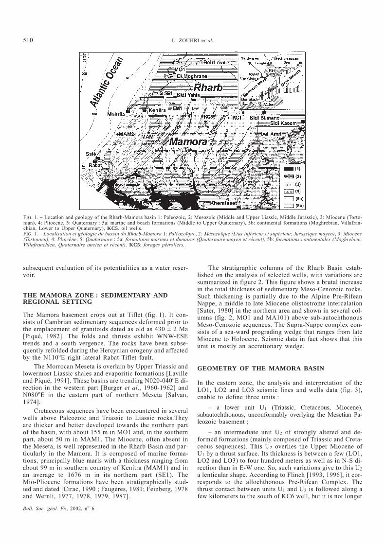
Cretaceous sequences have been encountered in severalwells above Paleozoic and Triassic to Liassic rocks.Theyare thicker and better developed towards the northern partof the basin, with about 155 m in MO1 and, in the southernpart, about 50 m in MAM1. The Miocene, often absent inthe Meseta, is well represented in the Rharb Basin and par-ticularly in the Mamora. It is composed of marine forma-tions, principally blue marls with a thickness ranging fromabout 99 m in southern country of Kenitra (MAM1) and inan average to 1676 m in its northern part (SE1). TheMio-Pliocene formations have been stratigraphically stud-ied and dated [Cirac, 1990 ; Faugères, 1981; Feinberg, 1978and Wernli, 1977, 1978, 1979, 1987].
The stratigraphic columns of the Rharb Basin estab-lished on the analysis of selected wells, with variations aresummarized in figure 2. This figure shows a brutal increasein the total thickness of sedimentary Meso-Cenozoic rocks.Such thickening is partially due to the Alpine Pre-RifeanNappe, a middle to late Miocene olistostrome intercalation[Suter, 1980] in the northern area and shown in several col-umns (fig. 2, MO1 and MA101) above sub-autochthonousMeso-Cenozoic sequences. The Supra-Nappe complex con-sists of a sea-ward prograding wedge that ranges from lateMiocene to Holocene. Seismic data in fact shows that thisunit is mostly an accretionary wedge.
GEOMETRY OF THE MAMORA BASIN
In the eastern zone, the analysis and interpretation of theLO1, LO2 and LO3 seismic lines and wells data (fig. 3),enable to define three units :
– a lower unit U1 (Triassic, Cretaceous, Miocene),subautochthonous, unconformably overlying the Mesetian Pa-leozoic basement ;
– an intermediate unit U2 of strongly altered and de-formed formations (mainly composed of Triassic and Creta-ceous sequences). This U2 overlies the Upper Miocene ofU1 by a thrust surface. Its thickness is between a few (LO1,LO2 and LO3) to four hundred meters as well as in N-S di-rection than in E-W one. So, such variations give to this U2
a lenticular shape. According to Flinch [1993, 1996], it cor-responds to the allochthonous Pre-Rifean Complex. Thethrust contact between units U1 and U3 is followed along afew kilometers to the south of KC6 well, but it is not longer
Bull. Soc. géol. Fr., 2002, no 6
510 L. ZOUHRI et al.
FIG. 1. – Location and geology of the Rharb-Mamora basin 1: Paleozoic, 2: Mesozoic (Middle and Upper Liassic, Middle Jurassic), 3: Miocene (Torto-nian), 4: Pliocene, 5: Quaternary : 5a: marine and beach formations (Middle to Upper Quaternary), 5b: continental formations (Moghrebian, Villafran-chian, Lower to Upper Quaternary), KC5. oil wells.FIG. 1. – Localisation et géologie du bassin du Rharb-Mamora 1: Paléozoïque, 2: Mésozoïque (Lias inférieur et supérieur, Jurassique moyen), 3: Miocène(Tortonien), 4: Pliocène, 5: Quaternaire : 5a: formations marines et dunaires (Quaternaire moyen et récent), 5b: formations continentales (Moghrebien,Villafranchien, Quaternaire ancien et récent), KC5: forages pétroliers.
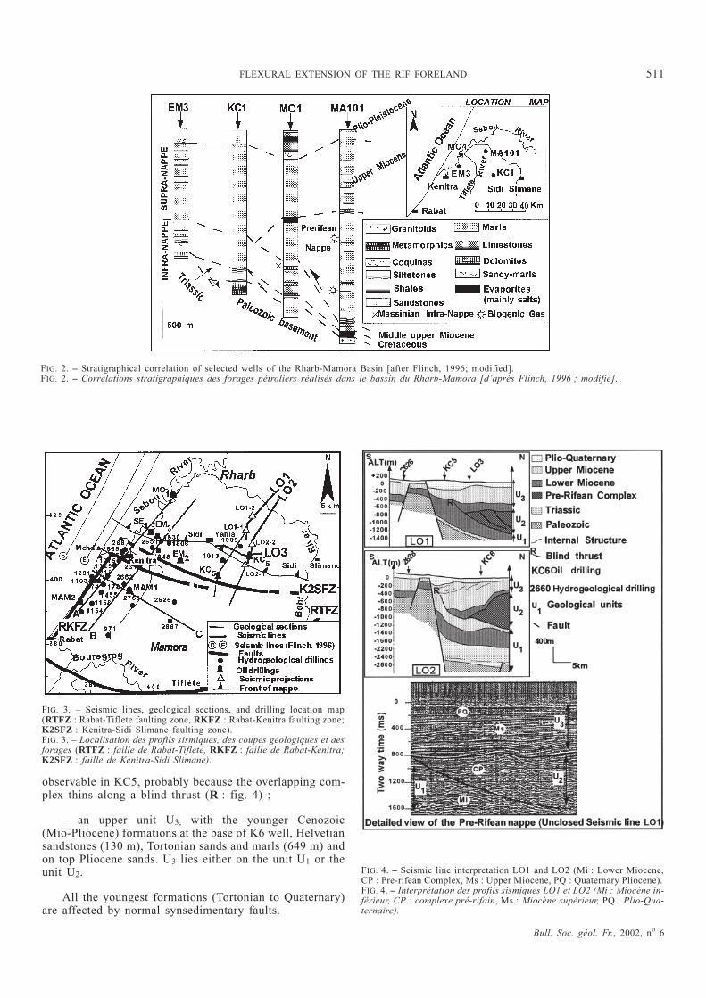
observable in KC5, probably because the overlapping com-plex thins along a blind thrust (R : fig. 4) ;
– an upper unit U3, with the younger Cenozoic(Mio-Pliocene) formations at the base of K6 well, Helvetiansandstones (130 m), Tortonian sands and marls (649 m) andon top Pliocene sands. U3 lies either on the unit U1 or theunit U2.
All the youngest formations (Tortonian to Quaternary)are affected by normal synsedimentary faults.
Bull. Soc. géol. Fr., 2002, no 6
FLEXURAL EXTENSION OF THE RIF FORELAND 511
FIG. 2. – Stratigraphical correlation of selected wells of the Rharb-Mamora Basin [after Flinch, 1996; modified].FIG. 2. – Corrélations stratigraphiques des forages pétroliers réalisés dans le bassin du Rharb-Mamora [d’après Flinch, 1996 ; modifié].
FIG. 3. – Seismic lines, geological sections, and drilling location map(RTFZ : Rabat-Tiflete faulting zone, RKFZ : Rabat-Kenitra faulting zone;K2SFZ : Kenitra-Sidi Slimane faulting zone).FIG. 3. – Localisation des profils sismiques, des coupes géologiques et desforages (RTFZ : faille de Rabat-Tiflete, RKFZ : faille de Rabat-Kenitra;K2SFZ : faille de Kenitra-Sidi Slimane).
FIG. 4. – Seismic line interpretation LO1 and LO2 (Mi : Lower Miocene,CP : Pre-rifean Complex, Ms : Upper Miocene, PQ : Quaternary Pliocene).FIG. 4. – Interprétation des profils sismiques LO1 et LO2 (Mi : Miocène in-férieur, CP : complexe pré-rifain, Ms.: Miocène supérieur, PQ : Plio-Qua-ternaire).
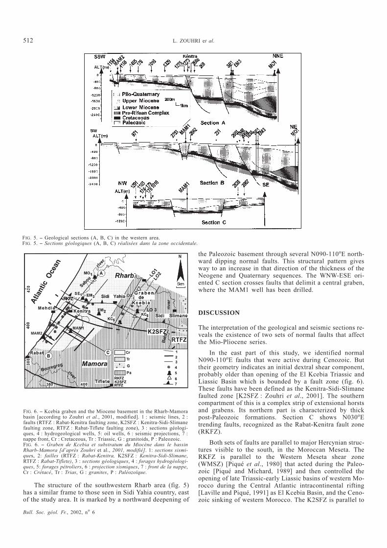
The structure of the southwestern Rharb area (fig. 5)has a similar frame to those seen in Sidi Yahia country, eastof the study area. It is marked by a northward deepening of
the Paleozoic basement through several N090-110oE north-ward dipping normal faults. This structural pattern givesway to an increase in that direction of the thickness of theNeogene and Quaternary sequences. The WNW-ESE ori-ented C section crosses faults that delimit a central graben,where the MAM1 well has been drilled.
DISCUSSION
The interpretation of the geological and seismic sections re-veals the existence of two sets of normal faults that affectthe Mio-Pliocene series.
In the east part of this study, we identified normalN090-110oE faults that were active during Cenozoic. Buttheir geometry indicates an initial dextral shear component,probably older than opening of the El Kcebia Triassic andLiassic Basin which is bounded by a fault zone (fig. 6).These faults have been defined as the Kenitra-Sidi-Slimanefaulted zone [K2SFZ : Zouhri et al., 2001]. The southerncompartment of this is a complex strip of extensional horstsand grabens. Its northern part is characterized by thickpost-Paleozoic formations. Section C shows N030oEtrending faults, recognized as the Rabat-Kenitra fault zone(RKFZ).
Both sets of faults are parallel to major Hercynian struc-tures visible to the south, in the Moroccan Meseta. TheRKFZ is parallel to the Western Meseta shear zone(WMSZ) [Piqué et al., 1980] that acted during the Paleo-zoic [Piqué and Michard, 1989] and then controlled theopening of late Triassic-early Liassic basins of western Mo-rocco during the Central Atlantic intracontinental rifting[Laville and Piqué, 1991] as El Kcebia Basin, and the Ceno-zoic sinking of western Morocco. The K2SFZ is parallel to
Bull. Soc. géol. Fr., 2002, no 6
512 L. ZOUHRI et al.
FIG. 5. – Geological sections (A, B, C) in the western area.FIG. 5. – Sections géologiques (A, B, C) réalisées dans la zone occidentale.
FIG. 6. – Kcebia graben and the Miocene basement in the Rharb-Mamorabasin [according to Zouhri et al., 2001, modified]. 1 : seismic lines, 2 :faults (RTFZ : Rabat-Kenitra faulting zone, K2SFZ : Kenitra-Sidi-Slimanefaulting zone, RTFZ : Rabat-Tiflete faulting zone), 3 : sections géologi-ques, 4 : hydrogeological wells, 5: oil wells, 6 : seismic projections, 7 :nappe front, Cr : Cretaceous, Tr : Triassic, G : granitoids, P : Paleozoic.FIG. 6. – Graben de Kcebia et substratum du Miocène dans le bassinRharb-Mamora [d’après Zouhri et al., 2001, modifié]. 1: sections sismi-ques, 2: failles (RTFZ : Rabat-Kenitra, K2SFZ : Kenitra-Sidi-Slimane,RTFZ : Rabat-Tiflete), 3 : sections géologiques, 4 : forages hydrogéologi-ques, 5: forages pétroliers, 6 : projection sismiques, 7 : front de la nappe,Cr : Crétacé, Tr : Trias, G : granites, P : Paléozoïque.

the Rabat-Tiflet fault active during early and late Paleozoic[Piqué, 1982] and was reactived during Triassic rifting.
So this frame suggests that the RKFZ, RTFZ andK2SFZ, in this part of Rharb basin, are re-activatedHercynian faults. They were revived as normal faults due toflexural extension in the Rharb foreland basin [Flinch,1996] due to the tectonic loading of the orogenic Rifeanzones during Neogene time. In the Rharb basin itself, andeven in the northern parts of the Mamora, the Paleozoicbasement is deeply buried and the structures of its Neogenecover are at ductile-brittle limit in low cohesive force mate-rials. By contrast, South of the Mamora, the Meseta be-haved at that time as a rigid block. Between these two areas,the Mamora is a transition zone which allows demonstrationthat Hercynian structures control the subsidence of the Rifforeland.
CONCLUSION
The Rharb foreland basin and its southern Mamora sub-ba-sin developed in the course of the late events of the Riforogeny. In the Mamora, the relatively smaller thickness ofthe post-Paleozoic cover does not mask the importance of
the bordering faults trending N030oE and N090- 100oE, thatlimit the Rharb basin to the west and to the south. These areformer Hercynian wrench faults reactivated as normal faultzones during the Neogene due to flexural extension. Threephases of fault activity are identified :
• Paleozoic (K2SFZ, RTFZ and RKFZ), with probablyleft component along N110oE fault zones ;
• Triassic-Jurassic rifting associated to basin opening(horst and graben structures) and sinistral component alongN110oE fault zones ;
• late Neogene normal fault (flexural extension) in thewhole Rharb Basin, syn- to post-thrust of Rif nappes.
The thickening of the permeable formations towards thenorth and the Atlantic Ocean is controlled by normal fault-ing. These formations constitute the Plio-Quaternary aqui-fer of the Rharb-Mamora and characterize the potential ofthe basin as water reservoir. In a next paper, we will studytheir hydrogeology and establish the relation between nor-mal faulting and groundwater flow.
Acknowledgements. – We would like thank J. Flinch, C. Doglioni and J.Verges for reviewing a first draft of this paper and for helpful and stimula-ting comments.
References
BURGER J.J., HOUSSE B. & LÉVY R. (1960-1962). – Contribution des tra-vaux d’exploration de la Société Chérifienne des Pétroles à laconnaissance de la nappe prérifaine. In : Livre mémoire P. Fal-lot. – Mém. h. Sér. Soc. géol. Fr., 1, 423-430.
CHALOUAN A., MICHARD A., FEINBERG H., MONTIGNY R. & SADDIQI O.(2001). – The Rif mountain building (Morocco) : a new tectonicscenario. – Bull. Soc. géol. Fr., 172, 5, 603-616.
CIRAC P. (1990). – Interférence des facteurs régionaux et du glacio-eusta-tisme sur la sédimentation du Néogène terminal du bassinsud-rifain occidental. – Paléobiologie continentale, XVII,p. 107-123.
FAUGÈRES J C. (1978). – Les rides sud-rifaines. Evolution sédimentaire etstructurale d’un bassin atlantico-mésogéen de la marge afri-caine. – Thèse État, Bordeaux I, 2 vol. 480 p.
FAUGÈRES J. C. (1981). – Evolution structurale d’un bassin atlantico-méso-géen de la marge africaine, les rides sud-rifaines (Maroc). –Bull. Soc. géol. Fr. (7), XXII, 3 , 229-244.
FEINBERG H. (1978). – Les séries tertiaires du Prérif et des dépendancespost-tectoniques du Rif. – Thèse d’Etat. Sc. Nat, Univ Toulouse,211 p.
FERNANDEZ M., BERASTEGUI X., PUIG C., GARCIA-CASTELLANOS D., JURADO
M.J., TORNE M. & BANKS C. (1998). – Geophysical and geologi-cal constraints on the evolution of the Guadalquivir foreland ba-sin. Spain. In : A. MASCLE, C. PUIGDEFABREGAS, H.P.LUTERBACHER & M. FERNANDEZ Eds., Cenozoic foreland basinsof western Europe. – Geol. Soc. Spec. Publ., 29-48.
FLINCH J.F. (1993). – Tectonic evolution of the Gibraltar Arc. – Unpubli-shed Ph. D. Thesis, Rice University, Houston, Texas, 381 p.
FLINCH J. (1996). – Accretion and extensional collapse of the external wes-tern Rif (northern Morocco). In : P.A. ZIEGLER & F. HORVATH
Eds, Peri-Tethys Memoir 2 : Structure and prospects of Alpinebasins and forelands. – Mém. Mus. Natn. Hist. Nat. Paris, 170,61-85.
FRIZON DE LAMOTTE D., SAINT BEZAR B., BRACENE R. & MERCIER E.(2000). – The two main steps of the Atlas building and geodyna-mics of the western Mediterranean. – Tectonics, 19, 740-761.
LAVILLE E. & PIQUÉ A. (1991). – La distension crustale atlasique au Marocau début du Mésozoïque : le rejeu des structures hercyniennes. –Bull. Soc. géol. Fr., 162, 6, 1161-1171.
MICHARD A., CHALOUAN A., FEINBERG H., GOFFÉ B. & MONTIGNY R.(2002). – How does the Alpine belt end between Spain and Mo-rocco ? – Bull. Soc. géol. Fr., 173, 1, 3-15.
PIQUÉ A. (1982). – La zone de Rabat-Tiflet (Meseta marocaine septentrio-nale). Sa place dans l’ensemble des noyaux paléozoïques de laMéditerranée occidentale. – C. R. Acad. Sci., Paris, 295,263-266.
PIQUÉ A., JEANNETTE D. & MICHARD A. (1980). – The western Mesetashear zone, a major and permanent feature of the Hercynian beltin Morocco. – J. Struct. Geol., 1/2, 55-61.
PIQUÉ A. & MICHARD A. (1989). – Moroccan Hercynides : a synopsis. ThePaleozoic sedimentary and tectonic evolution at the northernmargin of West Africa. – Am. J. Sci., 289, 286-330.
SALVAN H M. (1974). – Les séries salifères du Trias marocain. Caractèresgénéraux et possibilités d’interprétation. – Bull. Soc.géol. Fr.,(7), XVI, 724-731.
SUTER G. (1980). – Carte géologique de la chaîne rifaine. 1:50.000. – Serv.
Geol. du Maroc, Notes et Mémoires, 245a.
WERNLI R. (1977). – Les foraminifères planctoniques de la limite mio-plio-cène dans les environs de Rabat (Maroc). – Eclogae geol. Helv.70/1, 43-191.
WERNLI R. (1978). – La base du Moghrébien est d’âge pliocène moyen(zone à Globorotalia crassaformis) dans la Mamora (Maroc). –Arch. Sc. Genève, 31/2, 129-132.
WERNLI R. (1979). – Le Pliocène de la Mamora (Maroc) : stratigraphie etforaminifères planctoniques. – Eclogae geol. Helv. 72/11, Bâle,119-143.
WERNLI R. (1987). – Micropaléontologie du Néogène post-nappes du Ma-roc septentrional et description systématique des foraminifèresplanctoniques. – Notes et Mém. Serv. Géol, Rabat, Maroc, 331,265 p.
ZOUHRI L., LAMOUROUX C. & BURET C. (2001). – La Mamora, charnièreentre la Meseta et le Rif. Son importance dans l’évolution géo-dynamique post-paléozoïque du Maroc. – Geodin. Acta, 14,361-372.
Bull. Soc. géol. Fr., 2002, no 6
FLEXURAL EXTENSION OF THE RIF FORELAND 513