Evaluation of Effects of Groundwater Withdrawals at the Proposed ...
16
U.S. Department of the Interior U.S. Geological Survey Scientific Investigations Report 2016–5072 Prepared in cooperation with the Tennessee Valley Authority Evaluation of Effects of Groundwater Withdrawals at the Proposed Allen Combined-Cycle Combustion Turbine Plant, Shelby County, Tennessee
Transcript of Evaluation of Effects of Groundwater Withdrawals at the Proposed ...
U.S. Department of the InteriorU.S. Geological Survey
Scientific Investigations Report 2016–5072
Prepared in cooperation with the Tennessee Valley Authority
Evaluation of Effects of Groundwater Withdrawals at the Proposed Allen Combined-Cycle Combustion Turbine Plant, Shelby County, Tennessee

Evaluation of Effects of Groundwater Withdrawals at the Proposed Allen Combined-Cycle Combustion Turbine Plant, Shelby County, Tennessee
By Connor J. Haugh
Prepared in cooperation with the Tennessee Valley Authority
Scientific Investigations Report 2016–5072
U.S. Department of the InteriorU.S. Geological Survey

U.S. Department of the InteriorSALLY JEWELL, Secretary
U.S. Geological SurveySuzette M. Kimball, Director
U.S. Geological Survey, Reston, Virginia: 2016
For more information on the USGS—the Federal source for science about the Earth, its natural and living resources, natural hazards, and the environment—visit http://www.usgs.gov or call 1–888–ASK–USGS.
For an overview of USGS information products, including maps, imagery, and publications, visit http://store.usgs.gov.
Any use of trade, firm, or product names is for descriptive purposes only and does not imply endorsement by the U.S. Government.
Although this information product, for the most part, is in the public domain, it also may contain copyrighted materials as noted in the text. Permission to reproduce copyrighted items must be secured from the copyright owner.
Suggested citation:Haugh, C.J., 2016, Evaluation of effects of groundwater withdrawals at the proposed Allen combined-cycle combustion turbine plant, Shelby County, Tennessee: U.S. Geological Survey Scientific Investigations Report 2016–5072, 8 p., http://dx.doi.org/10.3133/sir20165072.
ISSN 2328-0328 (online)
iii
Contents
Abstract ...........................................................................................................................................................1Introduction.....................................................................................................................................................1
Purpose and Scope ..............................................................................................................................1Approach ................................................................................................................................................2
Regional Model ..............................................................................................................................................3Effects of Groundwater Withdrawals .........................................................................................................3Model Limitations...........................................................................................................................................4Summary..........................................................................................................................................................7References ......................................................................................................................................................7
Figures
1. Map showing location of the proposed Allen combined-cycle combustion turbine plant, Shelby County, Tennessee ..................................................................................2
2. Map showing simulated potentiometric surface change in the Memphis aquifer at the end of the 30-year average withdrawal period at the proposed Allen combined-cycle combustion turbine plant, Shelby County, Tennessee ..............................5
3. Map showing simulated potentiometric surface change in the Memphis aquifer at the end of the Tennessee Valley Authority withdrawal scenario at the proposed Allen combined-cycle combustion turbine plant, Shelby County, Tennessee ...................6
4. Graph showing periodic water levels in well Sh:J-140 from 1968 to 2015, Davis well field, Shelby County, Tennessee ........................................................................................7
Table
1. Generalized correlation chart of units of Tertiary age of the Claiborne and Wilcox Groups in West Tennessee and northern Mississippi ..............................................3

iv
Conversion Factors U.S. customary units to International System of Units
Multiply By To obtain
Length
foot (ft) 0.3048 meter (m)mile (mi) 1.609 kilometer (km)
Area
acre 4,047 square meter (m2)acre 0.004047 square kilometer (km2)square mile (mi2) 2.590 square kilometer (km2)
Flow rate
gallon per minute (gal/min) 0.06309 liter per second (L/s)
Datum Horizontal coordinate information is referenced to the North American Datum of 1983 (NAD 83).

Evaluation of Effects of Groundwater Withdrawals at the Proposed Allen Combined-Cycle Combustion Turbine Plant, Shelby County, Tennessee
By Connor J. Haugh
AbstractThe Mississippi Embayment Regional Aquifer Study
groundwater-flow model was used to simulate the potential effects of future groundwater withdrawals at the proposed Allen combined-cycle combustion turbine plant in Shelby County, Tennessee. The scenario used in the simulation con-sisted of a 30-year average withdrawal period followed by a 30-day maximum withdrawal period. Effects of withdrawals at the Allen plant site on the Mississippi embayment aquifer sys-tem were evaluated by comparing the difference in simulated water levels in the aquifers at the end of the 30-year average withdrawal period and at the end of the scenario to a base case without the Allen combined-cycle combustion turbine plant withdrawals. Simulated potentiometric surface declines in the Memphis aquifer at the Allen plant site were about 7 feet at the end of the 30-year average withdrawal period and 11 feet at the end of the scenario. The affected area of the Memphis aquifer at the Allen plant site as delineated by the 4-foot potentiometric surface-decline contour was 2,590 acres at the end of the 30-year average withdrawal period and 11,380 acres at the end of the scenario. Simulated declines in the underlying Fort Pillow aquifer and overlying shallow aquifer were both less than 1 foot at the end of the 30-year average withdrawal period and the end of the scenario.
IntroductionThe Tennessee Valley Authority (TVA) proposes to
reduce sulfur dioxide emissions at its Allen Fossil Plant (ALF) in Shelby County, Tennessee, by retiring the coal units and constructing a natural gas power plant. The existing coal-fired units at the ALF provide real and reactive power for the Mem-phis, Tennessee, area. To continue to reliably serve the area, generation resources must be located at or near the ALF. The proposed plant will be a two-on-one natural gas plant that can run in either simple- or combined-cycle mode. The simple-cycle mode uses very little water, whereas the combined-cycle mode is projected to use an annual average of 2,500 gallons
per minute (gal/min) and a maximum of 5,000 gal/min from wells screened in the Memphis aquifer (table 1).
In 2016, the U.S. Geological Survey (USGS), in coopera-tion with the TVA, conducted an investigation to define the potential effects of groundwater withdrawals associated with the proposed Allen combined-cycle combustion turbine plant (hereafter referred to as the Allen plant site) on water levels in the Mississippi embayment aquifer system. Groundwater from the Memphis and Fort Pillow aquifers, which are in the Mis-sissippi embayment aquifer system, is used to supply munici-pal and industrial water needs in West Tennessee (Parks and Carmichael, 1989, 1990). Self-supplied domestic groundwater withdrawals are usually from shallower zones including the alluvium or the fluvial deposits, which constitute the shallow aquifer at many locations.
The Mississippi Embayment Regional Aquifer Study (MERAS) was completed as part of the USGS Groundwater Resources Program to assess groundwater availability within the Mississippi embayment. The primary tool used in the assessment of groundwater availability is the MERAS groundwater-flow model (Clark and Hart, 2009). In the study described in this report, the effects of groundwater withdrawals associated with operation of the proposed Allen plant site were estimated by using the MERAS groundwater-flow model.
Purpose and Scope
This report presents an analysis of the potential effects of groundwater withdrawals associated with operation of the proposed Allen combined-cycle combustion turbine plant in Shelby County, Tennessee (fig. 1). The effects of groundwater withdrawals at the Allen plant site, in conjunction with exist-ing withdrawals, were analyzed using the MERAS groundwater-flow model (Clark and Hart, 2009). This analysis will help further the understanding and evaluation of the effects of increased water use on an important multistate aquifer. This report does not address the potential effects of water leakage from the shallow aquifer on groundwater quality in the Memphis aquifer.

2 Evaluation of Effects of Groundwater Withdrawals at the Proposed Allen Combined-Cycle Combustion Turbine Plant
Approach
The effects on water levels in the aquifer system from the Allen plant site withdrawals were evaluated by comparing the difference in simulated water levels in the aquifers at the end of the 30-year average withdrawal period and at the end of the scenario (30-year average plus 30-day maximum withdrawal, hereafter referred to as the TVA withdrawal scenario) to a base case with no withdrawals at the Allen plant site. The differences in water levels between the simulations with and without the Allen plant withdrawals were contoured to provide an overall measure of withdrawal effects. The areas encompassed by
the –4-ft potentiometric surface change contour were used to compare the affected areas (Haugh, 2012).
The Allen plant site (fig. 1) is simulated to have an annual average groundwater withdrawal of 2,500 gal/min and a 30-day maximum groundwater withdrawal of 5,000 gal/min. The wells at the proposed site would pump water from the Memphis aquifer (table 1). The rate of groundwater with-drawal by the proposed Allen combined-cycle combustion plant was assumed to be constant at the annual average rate over the 30-year period. This same approach was used during an investigation by the USGS, in cooperation with the TVA, conducted during 2008–2009 to define the potential effects of
ral16-7002_fig 01
40
40
240240
55
55
Sh:J-140
ALLEN
SHEAHAN
McCORD
DAVIS
MORTON
LICHTERMAN
MALLORY
PALMER
Allen plant site
Wolf River
Loosahatchie River
Coldwate
r Rive
r
Mississip
pi River
Nonconnah Creek
SHELBY
DE SOTO
CRITTENDEN
TUNICA
LEE
ST FRANCIS
TATETATE
ARKANSAS
MISSISSIPPI
TENNESSEE
89°45'W90°0'W90°15'W
35°15'N
35°0'N
Sh:J-140
0 2.5 5 MILES
0 2.5 5 KILOMETERSEXPLANATION
Memphis Light, Gas and Water Division well field
Observation well and number
Base from U.S. Geological Survey digital data, variously dated, various scales
Figure 1. Location of the proposed Allen combined-cycle combustion turbine plant, Shelby County, Tennessee.
Effects of Groundwater Withdrawals 3
groundwater withdrawals associated with the operation of five proposed combined-cycle combustion turbine plants on the Mississippi embayment aquifer system in West Tennessee and northern Mississippi (Haugh, 2012).
Regional Model
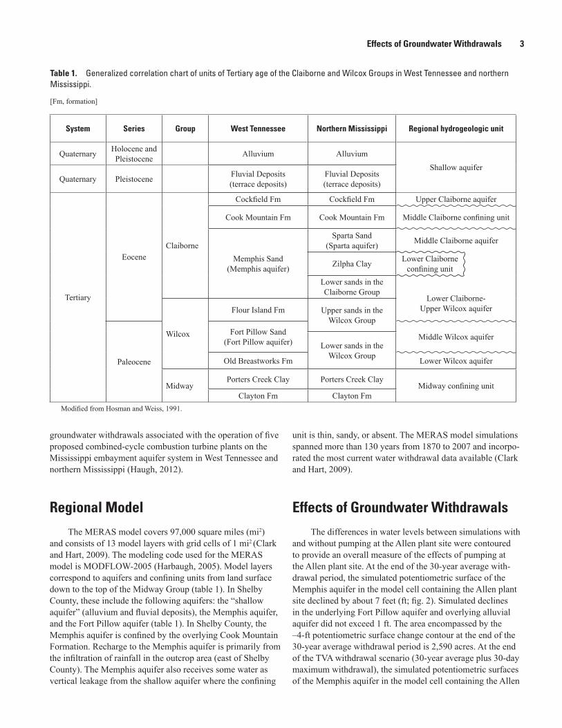
The MERAS model covers 97,000 square miles (mi2) and consists of 13 model layers with grid cells of 1 mi2 (Clark and Hart, 2009). The modeling code used for the MERAS model is MODFLOW-2005 (Harbaugh, 2005). Model layers correspond to aquifers and confining units from land surface down to the top of the Midway Group (table 1). In Shelby County, these include the following aquifers: the “shallow aquifer” (alluvium and fluvial deposits), the Memphis aquifer, and the Fort Pillow aquifer (table 1). In Shelby County, the Memphis aquifer is confined by the overlying Cook Mountain Formation. Recharge to the Memphis aquifer is primarily from the infiltration of rainfall in the outcrop area (east of Shelby County). The Memphis aquifer also receives some water as vertical leakage from the shallow aquifer where the confining
unit is thin, sandy, or absent. The MERAS model simulations spanned more than 130 years from 1870 to 2007 and incorpo-rated the most current water withdrawal data available (Clark and Hart, 2009).
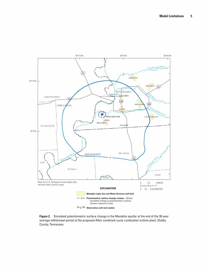
Effects of Groundwater Withdrawals
The differences in water levels between simulations with and without pumping at the Allen plant site were contoured to provide an overall measure of the effects of pumping at the Allen plant site. At the end of the 30-year average with-drawal period, the simulated potentiometric surface of the Memphis aquifer in the model cell containing the Allen plant site declined by about 7 feet (ft; fig. 2). Simulated declines in the underlying Fort Pillow aquifer and overlying alluvial aquifer did not exceed 1 ft. The area encompassed by the –4-ft potentiometric surface change contour at the end of the 30-year average withdrawal period is 2,590 acres. At the end of the TVA withdrawal scenario (30-year average plus 30-day maximum withdrawal), the simulated potentiometric surfaces of the Memphis aquifer in the model cell containing the Allen
Table 1. Generalized correlation chart of units of Tertiary age of the Claiborne and Wilcox Groups in West Tennessee and northern Mississippi.
[Fm, formation]
System Series Group West Tennessee Northern Mississippi Regional hydrogeologic unit
Quaternary Holocene and Pleistocene Alluvium Alluvium
Shallow aquiferQuaternary Pleistocene Fluvial Deposits
(terrace deposits)Fluvial Deposits (terrace deposits)
Tertiary
EoceneClaiborne
Cockfield Fm Cockfield Fm Upper Claiborne aquifer
Cook Mountain Fm Cook Mountain Fm Middle Claiborne confining unit
Memphis Sand(Memphis aquifer)
Sparta Sand(Sparta aquifer) Middle Claiborne aquifer
Zilpha Clay Lower Claiborne confining unit
Lower sands in the Claiborne Group
Lower Claiborne-Upper Wilcox aquifer
Wilcox
Flour Island Fm Upper sands in the Wilcox Group
Paleocene
Fort Pillow Sand(Fort Pillow aquifer) Middle Wilcox aquifer
Lower sands in the Wilcox GroupOld Breastworks Fm Lower Wilcox aquifer
MidwayPorters Creek Clay Porters Creek Clay
Midway confining unitClayton Fm Clayton Fm
Modified from Hosman and Weiss, 1991.

4 Evaluation of Effects of Groundwater Withdrawals at the Proposed Allen Combined-Cycle Combustion Turbine Plant
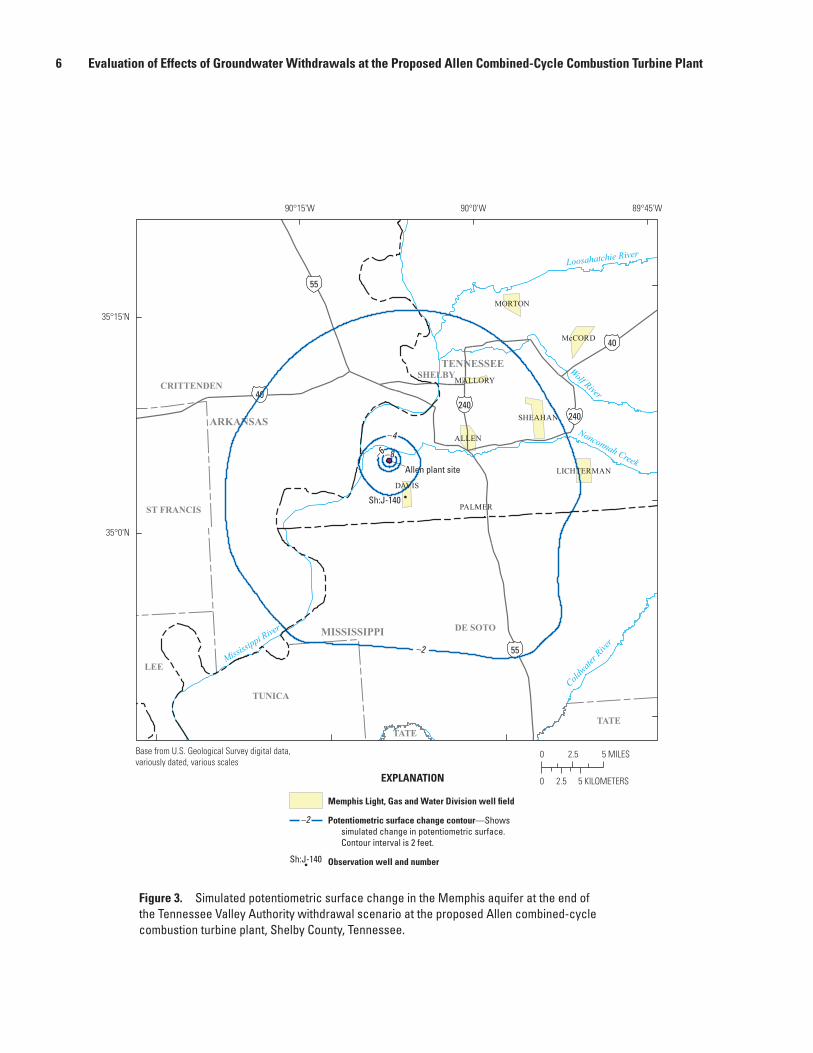
plant site declined by 11 ft (fig. 3). Simulated declines in the underlying Fort Pillow aquifer and overlying shallow aquifer did not exceed 1 ft. The area encompassed by the –4-ft poten-tiometric surface change contour (affected area) at the end of the TVA withdrawal scenario is 11,380 acres.
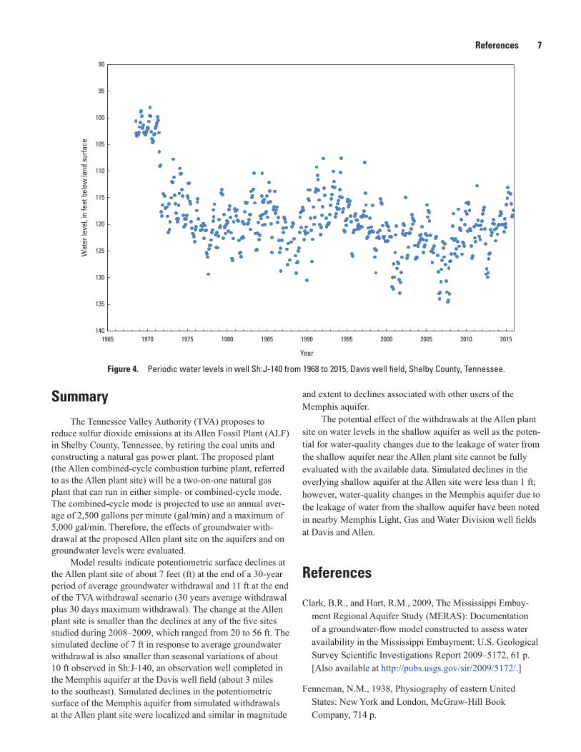
The simulated potentiometric surface decline of about 7 ft in response to the estimated average groundwater with-drawal at the Allen plant site can be compared to measured water levels from well Sh:J-140 (http://dx.doi.org/10.5066/F7P55KJN, USGS station no. 350124090072200), an obser-vation well completed in the Memphis aquifer and located in the Davis well field (about 3 miles [mi] to the southeast) (fig. 1). The Davis well field began withdrawals in August 1971 with average withdrawals of about 8,300 gal/min from 1972 through 2000 (Parks and others, 1995). In the early 2000s, withdrawals at the Davis well field increased and aver-aged about 12,900 gal/min from 2006 through 2014. Periodic water-level measurements from well Sh:J-140 show an initial decline during 1971–72 of about 20 ft due to withdrawals at the Davis well field (fig. 4). Annual water-level variations in subsequent years (1973–2015) in well Sh:J-140 average about 10 ft. Seasonal water-level fluctuations in the Memphis aquifer in the Davis well field area are related to variations in with-drawals at the well field or in the Memphis area (Parks and others, 1995). The simulated potentiometric surface declines at the Allen plant site of about 7 ft in response to average withdrawals at the Allen plant site would be less than the typi-cal seasonal variations in water levels observed in observation well Sh:J-140 at the Davis well field.
The simulated potentiometric surface decline of 11 ft at the end of the TVA withdrawal scenario at the Allen plant site is notably less than the simulated declines (20 to 56 ft) in source aquifers from the five sites previously analyzed by Haugh (2012). The affected area at the Allen site (11,380 acres) is near the minimum area from the five sites previously analyzed where affected areas ranged from 11,362 to 535,143 acres (Haugh, 2012). Pumping rates at the Allen site were similar to those at the previously studied sites where four of the five sites had annual average water withdrawals of 2,460 gal/min and 30-day maximum water withdrawals of 3,473 gal/min. The magnitude of change at all the sites and the spatial extent of affected areas varied depending on the transmissivity and storativity of the aquifers, the amount of confinement from
above and below, the withdrawal rates, and the effects of nearby boundary conditions (Haugh, 2012). At the Allen plant site, the simulated decline is smaller than the decline at any of the previously studied sites, most likely due to the greater thickness and transmissivity of the Memphis aquifer at the Allen plant site.
The simulations show less than a 1-ft decline in the overlying shallow aquifer; however, the potential effect of the withdrawals on water levels in the shallow aquifer as well as the potential for water-quality changes due to the leakage of water from the shallow aquifer near the Allen plant site cannot be fully evaluated with the available data and the scope of the current investigation. Water-quality changes in the Memphis aquifer due to the leakage of water from the shallow aquifer have been noted in nearby Memphis Light, Gas and Water Division well fields at Davis (about 3 mi to the southeast) (Parks and others, 1995) and at Allen (about 6 mi to the west) (Parks, 1990). The simulated declines in the potentiometric surface of the Memphis aquifer as a result of simulated with-drawals at the Allen plant site were localized and similar in magnitude and extent to declines associated with other users over the simulation period.
Model LimitationsModels are simplifications of natural systems. Factors
that affect how well a model represents a given natural system include the model scale, the accuracy and availability of hydraulic property data, the accuracy of withdrawal, water-level, and streamflow data, and appropriately defined boundary conditions. The MERAS model, used for the analy-sis presented in this report, is consistent with the conceptual model and hydrologic data of the MERAS study area. The MERAS model uses a grid-cell size of 1 mi2, and a model will not provide accurate prediction on a scale smaller than the grid resolution. The hydraulic-conductivity zones used in the MERAS model represent large-scale variation in hydraulic properties; the actual spatial variations of hydraulic properties of the aquifer system occur on a much smaller scale and are poorly defined. Further discussion of the limitations of the MERAS model are reported by Clark and Hart (2009, p. 56).
Model Limitations 5
ral16-7002_fig 02
40
40
240240
55
55
Sh:J-140
Wolf River
Loosahatchie River
Coldwate
r Rive
r
Mississip
pi River
Nonconnah Creek
SHELBY
DE SOTO
CRITTENDEN
TUNICA
LEE
ST FRANCIS
TATETATE
ARKANSAS
MISSISSIPPI
TENNESSEE
–2
–4
–6
–2
89°45'W90°0'W90°15'W
35°15'N
35°0'N
Sh:J-140
Allen plant site
0 2.5 5 MILES
0 2.5 5 KILOMETERSEXPLANATION
Memphis Light, Gas and Water Division well field
Potentiometric surface change contour—Shows simulated change in potentiometric surface. Contour interval is 2 feet.
Observation well and number
Base from U.S. Geological Survey digital data, variously dated, various scales
ALLEN
SHEAHAN
McCORD
DAVIS
MORTON
LICHTERMAN
MALLORY
PALMER
Figure 2. Simulated potentiometric surface change in the Memphis aquifer at the end of the 30-year average withdrawal period at the proposed Allen combined-cycle combustion turbine plant, Shelby County, Tennessee.
6 Evaluation of Effects of Groundwater Withdrawals at the Proposed Allen Combined-Cycle Combustion Turbine Plant
ral16-7002_fig 03
40
40
240240
55
55
Sh:J-140
Wolf River
Loosahatchie River
Coldwate
r Rive
r
Mississip
pi River
Nonconnah Creek
SHELBY
DE SOTO
CRITTENDEN
TUNICA
LEE
ST FRANCIS
TATETATE
ARKANSAS
MISSISSIPPI
TENNESSEE
–2
–4
–6–8
–2
89°45'W90°0'W90°15'W
35°15'N
35°0'N
Sh:J-140
Allen plant site
0 2.5 5 MILES
0 2.5 5 KILOMETERSEXPLANATION
Memphis Light, Gas and Water Division well field
Potentiometric surface change contour—Shows simulated change in potentiometric surface. Contour interval is 2 feet.
Observation well and number
Base from U.S. Geological Survey digital data, variously dated, various scales
ALLEN
SHEAHAN
McCORD
DAVIS
MORTON
LICHTERMAN
MALLORY
PALMER
Figure 3. Simulated potentiometric surface change in the Memphis aquifer at the end of the Tennessee Valley Authority withdrawal scenario at the proposed Allen combined-cycle combustion turbine plant, Shelby County, Tennessee.
References 7
ral16-7002_fig 04
90
95
100
105
110
115
120
125
130
135
1401965 1970 1975 1980 1985 1990 1995 2000 2005 2010 2015
Wat
er le
vel,
in fe
et b
elow
land
sur
face
Year
Figure 4. Periodic water levels in well Sh:J-140 from 1968 to 2015, Davis well field, Shelby County, Tennessee.
SummaryThe Tennessee Valley Authority (TVA) proposes to
reduce sulfur dioxide emissions at its Allen Fossil Plant (ALF) in Shelby County, Tennessee, by retiring the coal units and constructing a natural gas power plant. The proposed plant (the Allen combined-cycle combustion turbine plant, referred to as the Allen plant site) will be a two-on-one natural gas plant that can run in either simple- or combined-cycle mode. The combined-cycle mode is projected to use an annual aver-age of 2,500 gallons per minute (gal/min) and a maximum of 5,000 gal/min. Therefore, the effects of groundwater with-drawal at the proposed Allen plant site on the aquifers and on groundwater levels were evaluated.
Model results indicate potentiometric surface declines at the Allen plant site of about 7 feet (ft) at the end of a 30-year period of average groundwater withdrawal and 11 ft at the end of the TVA withdrawal scenario (30 years average withdrawal plus 30 days maximum withdrawal). The change at the Allen plant site is smaller than the declines at any of the five sites studied during 2008–2009, which ranged from 20 to 56 ft. The simulated decline of 7 ft in response to average groundwater withdrawal is also smaller than seasonal variations of about 10 ft observed in Sh:J-140, an observation well completed in the Memphis aquifer at the Davis well field (about 3 miles to the southeast). Simulated declines in the potentiometric surface of the Memphis aquifer from simulated withdrawals at the Allen plant site were localized and similar in magnitude
and extent to declines associated with other users of the Memphis aquifer.
The potential effect of the withdrawals at the Allen plant site on water levels in the shallow aquifer as well as the poten-tial for water-quality changes due to the leakage of water from the shallow aquifer near the Allen plant site cannot be fully evaluated with the available data. Simulated declines in the overlying shallow aquifer at the Allen site were less than 1 ft; however, water-quality changes in the Memphis aquifer due to the leakage of water from the shallow aquifer have been noted in nearby Memphis Light, Gas and Water Division well fields at Davis and Allen.
References
Clark, B.R., and Hart, R.M., 2009, The Mississippi Embay-ment Regional Aquifer Study (MERAS): Documentation of a groundwater-flow model constructed to assess water availability in the Mississippi Embayment: U.S. Geological Survey Scientific Investigations Report 2009–5172, 61 p. [Also available at http://pubs.usgs.gov/sir/2009/5172/.]
Fenneman, N.M., 1938, Physiography of eastern United States: New York and London, McGraw-Hill Book Company, 714 p.

8 Evaluation of Effects of Groundwater Withdrawals at the Proposed Allen Combined-Cycle Combustion Turbine Plant
Harbaugh, A.W., 2005, MODFLOW-2005, the U.S. Geological Survey modular ground-water model—The ground-water flow process: U.S. Geological Survey Techniques and Methods 6-A16 [variously paged].
Haugh, C.J., 2012, Effects of groundwater withdrawals associ-ated with combined-cycle combustion turbine plants in west Tennessee and northern Mississippi: U.S. Geological Survey Scientific Investigations Report 2012–5072, 22 p. [Also available at http://pubs.usgs.gov/sir/2012/5072/.]
Hosman, R.L., and Weiss, J.S., 1991, Geohydrologic units of the Mississippi embayment and Texas coastal uplands aquifer systems, south-central United States: U.S. Geological Survey Professional Paper 1416-B, 19 p. [Also available at https://pubs.er.usgs.gov/publication/pp1416B.]
Parks, W.S., 1990, Hydrogeology and preliminary assessment of the potential for contamination of the Memphis aquifer in the Memphis area, Tennessee: U.S. Geological Survey
Water-Resources Investigations Report 90–4092, 18 p. [Also available at https://pubs.er.usgs.gov/publication/wri904092.]
Parks, W.S., and Carmichael, J.K., 1989, Geology and ground-water resources of the Fort Pillow Sand in Western Tennessee: U.S. Geological Survey Water-Resources Inves-tigations Report 89–4120, 20 p. [Also available at http://pubs.usgs.gov/wri/wri89-4120/.]
Parks, W.S., and Carmichael, J.K., 1990, Geology and ground-water resources of the Memphis Sand in western Tennessee: U.S. Geological Survey Water-Resources Investigations Report 88–4182, 30 p. [Also available at http://pubs.usgs.gov/wri/wrir88-4182/.]
Parks, W.S., Mirecki, J.E., and Kingsbury, J.A., 1995, Hydro-geology, ground-water quality, and source of ground water causing water-quality changes in the Davis well field at Memphis, Tennessee: U.S. Geological Survey Water-Resources Investigations Report 94–4212, 59 p.

Publishing support provided by:Lafayette Publishing Service Center
For more information concerning this publication, contact: Chief, USGS Lower Mississippi-Gulf Water Science
Center–Tennessee (LMGWSC) 640 Grassmere Park, Suite 100 Nashville, TN 37211 (615) 837-4700
Or visit the LMGWSC Web site at: http://tn.water.usgs.gov/

Haugh—Evaluation of Effects of Groundw
ater Withdraw
als at the Proposed Allen Combined-Cycle Com
bustion Turbine Plant—Scientific Investigations Report 2016–5072
ISSN 2328-0328 (online)http://dx.doi.org/10.3133/sir20165072