Esriuk_track3_network rail
18
/ Stephen Brooks Geospatial Reporting Manager Asset Information: Data Services https://uk.linkedin.com/in/stephenrbrooks Geo-Analytics within Network Rail 29-May-15 1
Transcript of Esriuk_track3_network rail

/
Stephen BrooksGeospatial Reporting ManagerAsset Information: Data Services
https://uk.linkedin.com/in/stephenrbrooks
Geo-Analytics within Network Rail
29-May-15 1
/
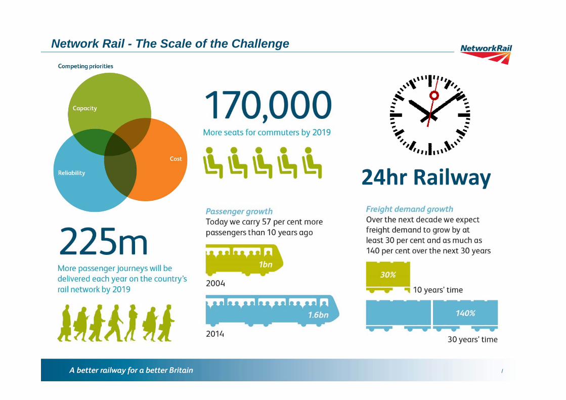
Network Rail - The Scale of the Challenge
24hr Railway

/
Network Rail - The Scale of our infrastructureNetwork Rail – AI National Intelligence Model

/
Vegetation Management
29-May-15 4

/29-May-15 5
Vegetation Management0-5m Vegetation Survey5+m Vegetation SurveyAll Vegetation SurveyIndividual Tree SurveyBoth Surveys

/29-May-15 6
Vegetation ManagementJanuaryJanuary - FebruaryJanuary - MarchJanuary - AprilJanuary - MayJanuary - JuneJanuary - JulyJanuary - AugustJanuary - SeptemberJanuary - OctoberJanuary - NovemberJanuary - DecemberWheel Slips & Vegetation

/
29-May-157
Vegetation ManagementOther Contributing FactorsWeather StationsRainfall - last 6hrsWind - last 24hrsEarthworksTrack Gradient

/29-May-15 8
National Aerial SurveyLiDAR Point Cloud

/
National Cross Section Analysis
29-May-15 9

/29-May-15 10
Cross Sectional Analysis

/29-May-15 11
Cross Sectional Analysis
Simpson’s Rule:

/
Generalised Centre-lineSplit the track into 50m100m perpendicular lines5m spot heightsExtrapolate height infoSelect cuttings > 4mBuffer & merge cuttings > 4mOverlaid with OS Terrain 5Cross Sectional Analysis
29-May-15 12

/29-May-15 13
Cross Sectional Analysis with LiDAR
Adaptable methodologyeasily integratedwith LiDAR
Increased densityof spot height samplingwith greater resolution

/
Using GIS to assist theSuicide Prevention team
29-May-15
Geo-Analytics within Network Rail - Stephen Brooks
14

/29-May-15
Geo-Analytics within Network Rail - Stephen Brooks
15

/29-May-15
Geo-Analytics within Network Rail - Stephen Brooks
16
Historic data trends show an incident happened atplace ‘X’ therefore prevention measures are introduced.
Historic data trends show an incident happened atplace ‘X’ therefore where on the network do we have similar locations?
ReactivePreventionPredictivePrevention

/29-May-15
Geo-Analytics within Network Rail - Stephen Brooks
17

/
Presentation Title: Insert > Header & Footer
29-May-15 18
Stephen BrooksGeospatial Reporting ManagerAsset Information: Data Services
https://uk.linkedin.com/in/stephenrbrooks