Eops 2014 09_16
44
September 16, 2014 Surface Conditions Report Eyes Over Puget Sound Field log Climate Water column Aerial photos Ferry and Satellite Moorings Publication No. 14-03-077 Start here Up-to-date observations of visible water quality conditions in Puget Sound and the Strait of Juan de Fuca Marine Water Condition Index
-
Upload
christopher-krembs -
Category
Education
-
view
78 -
download
0
Transcript of Eops 2014 09_16
September 16, 2014 Surface Conditions Report
Eyes Over Puget Sound Field log Climate Water column Aerial photos Ferry and Satellite Moorings
Publication No. 14-03-077
Start here
Up-to-date observations of visible water quality conditions in Puget Sound and the Strait of Juan de Fuca
Marine Water Condition Index

Personal field log p. 4 What is a phytoplankton bloom, really? Climate conditions p. 6 Sunshine and warm temperatures continue. The Fraser River flow is below normal, PDO and upwelling are above normal. Water column p. 7 As summer ends, temperatures are high in South Sound. Low dissolved oxygen levels are widespread in Puget Sound, yet remain high in Hood Canal. Moorings p. 38 At Mukilteo, continuous water temperature fluctuated and salinity declined. Upper mooring measured strong tidal effects. Aerial photography p. 11 Numerous and large patches of jellyfish seen in finger inlets of South Sound and East Sound (Orcas Island). Red-brown blooms remain strong in smaller bays inside Puget Sound. Suspended sediment from Nooksack and Skagit rivers are very visible. Ferry and satellite p. 40 Bloom in central Puget Sound begins to fade as temperatures cool. MODIS reveals extensive bloom at entrance to Strait of Juan de Fuca. Thermal imagery from Landsat 8 shows relatively warm water in Strait of Georgia, Whidbey Basin, and finger inlets of South Puget Sound.
LO
NG
-T
ER
M
MA
RIN
E
MO
NIT
OR
ING
U
NIT
Mya Keyzers Laura Hermanson
Joe Leatherman
Skip Albertson
Dr. Christopher Krembs
Guest: Dr. Brandon Sackmann,
Integral
Julia Bos Suzan Pool
www.ecy.wa.gov/programs/eap/mar_wat/eops/ Previous Eyes Over Puget Sound reports:
Marine conditions from 9-16-2014 at a g lance Field log Climate Water column Aerial photos Ferry and Satellite Moorings

http://www.eopugetsound.org/ Read about 2013 conditions in Puget Sound in the latest report from PSEMP
The Puget Sound Marine Waters: 2013 Overview • Informs on the marine water conditions and
associated biota in Puget Sound. It compiles the physical, chemical, and biological information obtained from diverse marine monitoring and observing programs.
• Represents a collaboration among agencies and scientists forming a collective view of marine water conditions to enhance the ecological understanding of Puget Sound.
• Includes many observations from bacteria to birds presented in context of climatic and physical conditions affecting our water ways.
http://www.psp.wa.gov/downloads/psemp/PSmarinewaters_2013_overview.pdf Front Cover Photo Credit: Jim Devereaux
Field log Climate Water column Aerial photos Ferry and Satellite Moorings

All About Phytoplankton: Part 1
Have you ever looked at water from Puget Sound under a microscope? You may be surprised at what you see! Microscopic single-celled algae called phytoplankton are a crucial part of the marine ecosystem and are the foundation of the Puget Sound food web. Two main types of phytoplankton are diatoms and dinoflagellates.
Dinoflagellates are also diverse and can be brown, red, orange, or green.
Diatoms come in many shapes and sizes, and are usually green or brown in color. Diatoms have a rigid cell wall made of silica, can form chains, and
contain chloroplasts which make them purely photosynthetic. They make their own food using sunlight.
Dinoflagellates have 1-2 flagella that help them migrate vertically in the water column and can form chains. Dinoflagellates have the ability to be photosynthetic, heterotrophic (consume other cells), or even mixotrophic (able to photosynthesize and consume other cells). When it comes to the lower food web, dinoflagellates rule because they are able to break all the rules!
Personal flight impression 9-16-2014 Field log Climate Water column Aerial photos Ferry and Satellite Moorings

Personal flight impression 9-16-2014 Field log Climate Water column Aerial photos Ferry and Satellite Moorings
What is a Bloom?
Blooms occur when planktonic cells divide at such high rates that their large biomass is visible to the eye. This typically happens in the spring and fall when nutrient and sunlight conditions are optimal. While not always visible from the water, we can easily see the color and expanse of blooms from the air. The color is caused by chlorophyll and other light-harvesting pigments. The majority of blooms are not harmful and are in fact naturally occurring. However, excess nutrients (mainly nitrogen) can fuel blooms and have negative effects on water quality. Over time, the location of blooms could indicate persistent nutrient sources.
Red bloom (dinoflagellates and diatoms).
Green algal mats.
Orange Noctiluca (dinoflagellate) bloom. Green diatom bloom.
Stay tuned for “All About Phytoplankton: Part 2” next month!

Field log Climate Water column Aerial photos Ferry and Satellite Moorings
Climate and natural influences before 9-16-2014
Summary: Air temperatures have generally been above normal continuing the trend of the past six months. Precipitation has not occurred for several days. The summer has been dry, yet a few large rain events have made it average normal. Sunshine levels have been above normal. River flows are below normal for the Fraser River, but near expected elsewhere. PDO remains in the warm phase and upwelling is above normal for the first time this summer, yet ocean intrusions (using a new Intrusion index) of low DO water have been sparse. lower higher expected No data
New section! Climate and natural influences are conditions that influence our marine waters, including weather, rivers, and the adjacent ocean (previously called Weather). For an explanation of the figure, see: http://www.ecy.wa.gov/programs/eap/mar_wat/weather.html, page 26.

We use a chartered float plane to access our monthly monitoring stations most cost effectively. We communicate data and environmental marine conditions using: 1. Marine Water
Condition Index (MWCI)
2. Eyes Over Puget Sound (EOPS)
3. Anomalies and source data
Field log Weather Water column Aerial photos Ferry and Satellite Moorings
Our long-term marine monitoring stations in Washington
Start here
Isl.
.

Salinity Variable Oxygen Stays Lower August 2014: Temperature variable Region
6 7 8 9 10 11 12 1 2 3 4 5 6 7 8 9 10 11 12 1 2 3 4 5 6 7 8
Grays Harbor
Willapa Bay
North Sound
San Juan
Whidbey Basin
Hood Canal
Central Sound
South Sound
20142012 20136 7 8 9 10 11 12 1 2 3 4 5 6 7 8 9 10 11 12 1 2 3 4 5 6 7 8
20142012 20136 7 8 9 10 11 12 1 2 3 4 5 6 7 8 9 10 11 12 1 2 3 4 5 6 7 8
20132012 2014
Physical conditions tracked in statistically historic context
In 2013, Puget Sound was warmer. Early 2014 started colder, and saltier with lower oxygen, then became fresher due to rain. At the end of summer, temperatures are high in South Sound and salinities and dissolved oxygen are low in Central Sound. Hood Canal remains unusually cold and high in DO.
Field log Weather Water column Aerial photos Ferry and Satellite Moorings

-25 -20 -15 -10 -5 0 5 10 15 20 25
-1.5
-1
-0.5
0
0.5
1
1.5
1945 1950 1955 1960 1965 1970 1975 1980 1985 1990 1995 2000 2005 2010 2015
a) Pacific Decadal Oscillation Index (PDO, temperature) (explanation) b) Upwelling Index (anomalies) (Upwelling, low oxygen) (explanation) c) North Pacific Gyre Oscillation Index (NPGO, productivity) (explanation)
NPG
O (x10)
PDO
/Upw
ellin
g Ind
ex
Three-year running average of PDO, Upwelling, and NPGO indices scores
Ocean boundary conditions have been favorable for water quality in Puget Sound: (a) colder water (PDO), (b) less upwelled low oxygen and high nutrient ocean water reaching Puget Sound (Upwelling Index), and (c) higher surface productivity along the coast (NPGO). Where are we heading next?
Field log Weather Water column Aerial photos Ferry and Satellite Moorings
.
The ocean affects water quality: Ocean Climate Indices
Explore the data
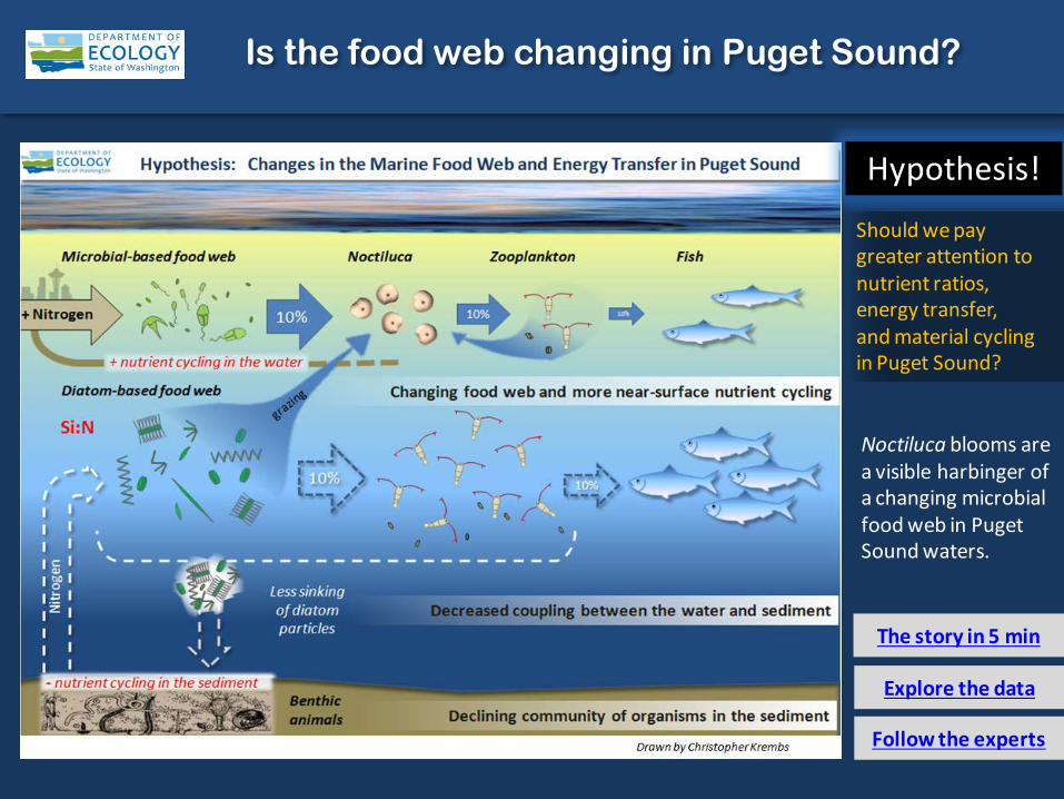
Is the food web changing in Puget Sound?
The story in 5 min
Follow the experts
Hypothesis!
Should we pay greater attention to nutrient ratios, energy transfer, and material cycling in Puget Sound?
Noctiluca blooms are a visible harbinger of a changing microbial food web in Puget Sound waters.

Summary: Aerial photography 9-16-2014
Numerous and large patches of jellyfish seen in finger inlets of South Sound and East Sound (Orcas Island). Red-brown blooms remain strong in smaller bays inside Puget Sound. Suspended sediment from Nooksack and Skagit Rivers are very visible.
Field log Weather Water column Aerial photos Ferry and Satellite Moorings
Start here Mixing and Fronts: Developed fronts and mixing visible by colored surface water.
Debris: Localized organic debris north and south of Lummi Island and along tidal fronts.
Visible blooms: Green-brown: Fidalgo Bay, Skagit Bay, Saratoga Passage, and Port Susan. Red-brown: Budd, Eld, Henderson, Carr, and Sinclair Inlets and Eagle Harbor.
Jellyfish: Jellyfish patches large and numerous in southern inlets of South Sound and East Sound (Orcas Island).
Bloo
m
Debr
is Fr
ont
Suspended sediment: Sediments in glacier-fed Skagit and Nooksack rivers influence a wide area.
Plum
e
Green: What is golf course, what is water?
Nothing at the surface in Port Gamble
Boat
Internal waves
Bloo
m
5 7
1 2 8 18
7 9 13 14
1 2 3 4 6 10 11 13 15 16 17
20
19
18
1 10 11 13 17 19 18

Strait of Juan de Fuca
San Juan Islands Padilla Bay
Main Basin
Hood Canal
South Sound
Field log Climate Water column Aerial photos Ferry and Satellite Moorings
Observation Maps:
Afternoon flight, photos 9-20: Overcast, hazy, calm
Flight Information:
Morning flight, photos 1-8 Overcast low visibility, calm
8
19
11
10
13 14
15
Aerial photography and navigation guide
20
6
Central and North Sound
South Sound
Seat
tle Ti
des:
H. t
ide:
12:
53 P
M 1
1:25
PM
, , L.
tide
: 5:0
8 A
M, 6
:36
PM
7
12
Whidbey Basin
5
Flight route and fueling stop
17
16
9
18
3
2
1
4

A. B.
Debr
is
Red-brown bloom and many patches of jellyfish. Location: A. Cooper Point. B. Gull Harbor, Budd Inlet (South Sound), 9:29 AM.
1 Aerial photography 9-16-2014 Navigate
Field log Climate Water column Aerial photos Ferry and Satellite Moorings
Boat
jellyfish
jellyfish
jellyfish
jellyfish
jellyfish
jellyfish
jellyfish
jellyfish
Bloo
m
Debr
is

A. B.
2 Navigate Aerial photography 9-16-2014 Field log Climate Water column Aerial photos Ferry and Satellite Moorings
Red-brown bloom and many jellyfish patches. Location: A. Off Frye Cove. B. Near Young Cove Eld Inlet (South Sound), 9:35 AM.
jellyfish
Bloo
m
jellyfish
jellyfish
jellyfish jellyfish
jellyfish
Bloo
m
jellyfish
Debr
is

3 Navigate Aerial photography 9-16-2014
Red-brown and turquoise blooms inside bay. Location: Sinclair Inlet (Central Sound), 9:53 AM.
Field log Climate Water column Aerial photos Ferry and Satellite Moorings
Boat
Bloo
m
Bloo
m

A. B.
4 Navigate
Field log Climate Water column Aerial photos Ferry and Satellite Moorings
Aerial photography 9-16-2014
Red-brown bloom inside the inlet. Location: Scow Bay, Marrowstone Island (Central Sound), 10:14 AM.
Bloo
m
boat
Bloo
m

5 Navigate Aerial photography 9-16-2014 Field log Climate Water column Aerial photos Ferry and Satellite Moorings
Two distinguishable water masses outline surface water movements. Location: Fort Ebey, Admiralty Reach (Central Sound), 10:21 AM.
Ship
Fron
t
Boat

Red-brown bloom traces patterns of water circulation in bay. Location: Mud Bay, Lopez Sound (San Juan Islands), 10:30 AM.
6 Navigate Aerial photography 9-16-2014 Field log Climate Water column Aerial photos Ferry and Satellite Moorings
Boat
Bloo
m
Bloo
m
Boat

Suspended sediment highlights mixing patterns of water entering from East Sound. Location: Deer Point, Obstruction Pass (San Juan Islands), 10:25 AM.
7 Navigate Aerial photography 9-16-2014 Field log Climate Water column Aerial photos Ferry and Satellite Moorings
mixing
Plum
e
mixing

Numerous patches of jellyfish. Location: Cascade Bay, East Sound (San Juan Islands), 11:14 AM.
8 Navigate Aerial photography 9-16-2014 Field log Climate Water column Aerial photos Ferry and Satellite Moorings
Boat
jellyfish
jellyfish jellyfish
jellyfish

Two distinguishable water masses with sediment-rich water from the Nooksack River . Location: Off Point Migley, Lummi Bay (North Sound), 12:05 PM.
9 Navigate Aerial photography 9-16-2014 Field log Climate Water column Aerial photos Ferry and Satellite Moorings
Boat
Boat
Plum
e
Boat
Boat
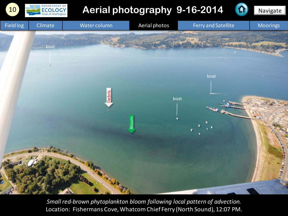
10 Navigate Aerial photography 9-16-2014
Small red-brown phytoplankton bloom following local pattern of advection. Location: Fishermans Cove, Whatcom Chief Ferry (North Sound), 12:07 PM.
Field log Climate Water column Aerial photos Ferry and Satellite Moorings
Bloo
m
boat
Debr
is
boat
boat

11 Navigate Aerial photography 9-16-2014
Large patches of organic surface debris and phytoplankton-rich water leaving bay. Location: Off Samish Island, Samish Bay (North Sound), 12:50 PM.
Field log Climate Water column Aerial photos Ferry and Satellite Moorings
Boat
Bloo
m
ship ship

Glacial-fed water from the Skagit River drives estuarine circulation in Whidbey Basin in the summer. Location: Swinomish Channel, Skagit Bay (Whidbey Basin), 1:22 PM.
12 Navigate
Field log Climate Water column Aerial photos Ferry and Satellite Moorings
Aerial photography 9-16-2014
boat
Swinomish Channel
Skagit River
jetty

Skagit River plume flowing northwest next to near-shore phytoplankton bloom. Location: Goat Island, Skagit River estuary (Whidbey Basin), 1:22 PM.
13 Navigate Aerial photography 9-16-2014
Bloo
m
Field log Climate Water column Aerial photos Ferry and Satellite Moorings
Plum
e
Debr
is

Sediment-rich water entering from Davis Slough by flowing over flooded mudflats. Location: Livingston Bay, Port Susan (Whidbey Basin), 1:51 PM.
14 Navigate
Field log Climate Water column Aerial photos Ferry and Satellite Moorings
Aerial photography 9-16-2014
submerged gully
Plum
e

15 Navigate
Field log Climate Water column Aerial photos Ferry and Satellite Moorings
A mix of sediment- and phytoplankton-rich water drifting southward over shallow water. Location: Off Triangle Cove, Port Susan (Whidbey Basin), 1:53 PM.
Aerial photography 9-16-2014
Bloo
m
Davis Slough Stillaguamish River

16 Navigate
Strong red-brown bloom highlights circulation pattern in bay. Location: Eagle Harbor, Bainbridge Island (Central Sound), 3:57 PM.
Aerial photography 9-16-2014 Field log Climate Water column Aerial photos Ferry and Satellite Moorings
Bloo
m
Boat

Fish pen
A. B.
17 Navigate
Field log Climate Water column Aerial photos Ferry and Satellite Moorings
Red-brown and golden-brown blooms along with small amounts of organic surface debris. Location: A. Allen Point, B. Henderson Bay, Carr Inlet (South Sound), 4:10 PM.
Aerial photography 9-16-2014
Bloo
m
Bloo
m
Bloo
m
Debr
is

Debr
is
18 Navigate
Field log Climate Water column Aerial photos Ferry and Satellite Moorings
Red-brown bloom and patches of jellyfish. Location: Over Woodland Bay Conservation Area, Henderson Inlet (South Sound), 4:20 PM.
Aerial photography 9-16-2014
boat
pilings Bl
oom
jellyfish
jellyfish

19 Navigate
Field log Climate Water column Aerial photos Ferry and Satellite Moorings
Red-brown bloom and patches of organic debris outlining pattern of circulation in inner bay. Location: Southern Henderson Inlet (South Sound), 4:20 PM.
Aerial photography 9-16-2014
Boat De
bris
Bloo
m
Boat

20 Navigate
Red-brown bloom outlining pattern of circulation in inner bay. Location: Southern Henderson Inlet (South Sound), 4:21 PM.
Aerial photography 9-16-2014
Bloo
m
Field log Climate Water column Aerial photos Ferry and Satellite Moorings

North Sound/San Juan Islands
Numbers on map refer to picture numbers for spatial reference
Date: 9-16-2014 Central Sound
Aerial photography observations in Central Sound Observations in Central and North Sound Navigate
Field log Climate Water column Aerial photos Ferry and Satellite Moorings
5
6
10 9
13 14
11
12
15
16
4
3
7
8

Date: 9-16-2014
Observations in Hood Canal and South Sound
Numbers on map refer to picture numbers for spatial reference
Navigate
Field log Climate Water column Aerial photos Ferry and Satellite Moorings
South Sound
17
18
19
20 1
2
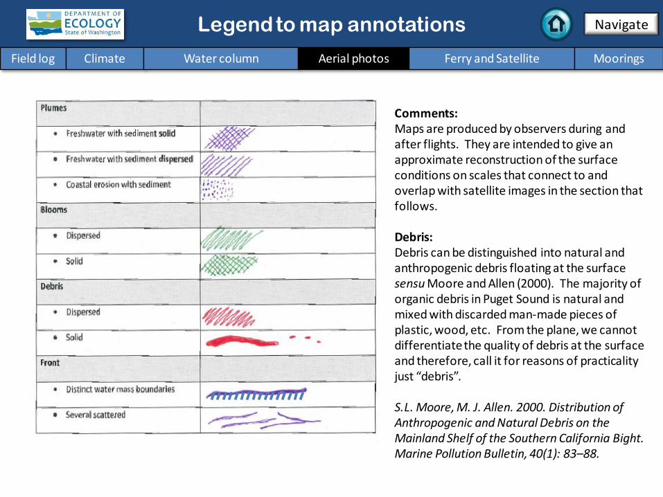
Legend to map annotations
Comments: Maps are produced by observers during and after flights. They are intended to give an approximate reconstruction of the surface conditions on scales that connect to and overlap with satellite images in the section that follows. Debris: Debris can be distinguished into natural and anthropogenic debris floating at the surface sensu Moore and Allen (2000). The majority of organic debris in Puget Sound is natural and mixed with discarded man-made pieces of plastic, wood, etc. From the plane, we cannot differentiate the quality of debris at the surface and therefore, call it for reasons of practicality just “debris”. S.L. Moore, M. J. Allen. 2000. Distribution of Anthropogenic and Natural Debris on the Mainland Shelf of the Southern California Bight. Marine Pollution Bulletin, 40(1): 83–88.
Navigate
Field log Climate Water column Aerial photos Ferry and Satellite Moorings

Current Conditions: Bloom in central Puget Sound begins to fade as
temperatures cool; max temperatures generally <15 °C. MODIS reveals extensive bloom at entrance to
Strait of Juan de Fuca. Thermal imagery from Landsat 8 shows warmer water in Strait of Georgia, Whidbey Basin, and finger inlets of South Puget Sound.
Brandon Sackmann Contact: [email protected]
26 July 2014
Hardware upgrades on the Victoria Clipper IV successfully restored near real-time data collection
as of July 23, 2014; we are back online!
Field log Climate Water column Aerial photos Ferry and Satellite Moorings
Ferry and satellite observations 9-16-2014
Start here
16 September 2014

C. Weak tides in August and September associated with warmer temperatures in Strait of Juan de Fuca.
A. Strong algae bloom in central Puget Sound during first week of September.
B. Stratification shows signs of weakening (temperature is declining indicating mixing) and bloom is dissipating.
C. C.
B.
B. A.
Field log Climate Water column Aerial photos Ferry and Satellite Moorings
Ferry and satellite observations 9-16-2014
3:47 PM
Victoria Clipper rendezvous near Kingston

Field log Climate Water column Aerial photos Ferry and Satellite Moorings
Ferry and satellite observations 9-16-2014
MODIS-Terra (top) and MODIS-Aqua (bottom) reveal intense offshore bloom near entrance
to Strait of Juan de Fuca!
True Color Turbidity
Chlorophyll
Imagery obtained from NASA’s OceanColor WEB http://oceancolor.gsfc.nasa.gov/

Field log Climate Water column Aerial photos Ferry and Satellite Moorings
Ferry and satellite observations 9-16-2014
Thermal imagery from the Landsat 8 satellite show warm waters throughout
Strait of Georgia and Whidbey Basin (left). Warmer temperatures were in finger inlets
throughout South Puget Sound; cooler temperatures highlight areas experiencing
increased mixing (top).
15 September 2014

Mooring observations and trends 9-4-2014 to 9-16-2014
Field log Climate Water column Aerial photos Ferry and Satellite Moorings
2-6 m depth
Dissolved oxygen not measured
12-16 m depth
These plots show the probability of observations over the past two-week period. High probability shown in warm colors. Left Panels: Density is defined by salinity and temperature. Right Panel: Dissolved oxygen concentration in relation to salinity.
At Mukilteo, we observed strong tidal effects from our upper mooring. On the lower mooring, temperature fluctuated, with a temporal pattern somewhat reverse of the daily tidal range. Technical issues may have affected the near-bottom salinity measurements. Variable winds and reduced river flows lessen the export of freshwater leaving Puget Sound.
Dissolved oxygen sensor issues; not presented

Mooring observations and trends 8-17-2014 to 9-16-2014
Click on icon to view real-time data of the moorings
Field log Climate Water column Aerial photos Ferry and Satellite Moorings
Our mooring station in Mukilteo is located in Whidbey Basin near Everett. It is also located at the transition between Possession and Central Sounds at a depth that is influenced by the Skagit and Snohomish river discharges, prevailing winds, and tidal mixing. As the largest regional contributor of freshwater to Puget Sound, understanding the timing and magnitude of the Skagit river flow is important. We present data of daily means for the past 31 days. Data are plotted in Pacific Standard Time. Wind data are from Paine Field in Everett. River flow data are from USGS.
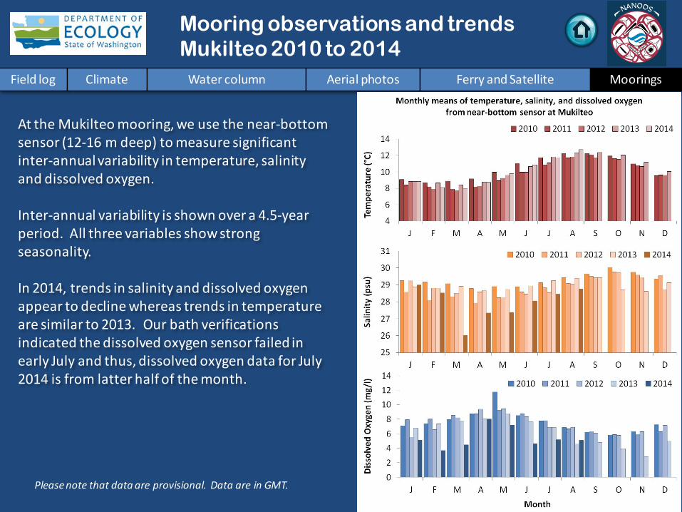
Mooring observations and trends Mukilteo 2010 to 2014
Field log Climate Water column Aerial photos Ferry and Satellite Moorings
Please note that data are provisional. Data are in GMT.
At the Mukilteo mooring, we use the near-bottom sensor (12-16 m deep) to measure significant inter-annual variability in temperature, salinity and dissolved oxygen. Inter-annual variability is shown over a 4.5-year period. All three variables show strong seasonality. In 2014, trends in salinity and dissolved oxygen appear to decline whereas trends in temperature are similar to 2013. Our bath verifications indicated the dissolved oxygen sensor failed in early July and thus, dissolved oxygen data for July 2014 is from latter half of the month.

Access mooring data:
ftp://www.ecy.wa.gov/eap/Mooring_Raw/Puget_S
ound/
Ferry and satellite : [email protected]
Get data from Ecology’s Marine Monitoring Programs
Long–Term Monitoring Network
Real–Time Sensor Network
Access core monitoring data: http://www.ecy.wa.gov/apps/eap/marinewq/mwda
taset.asp
Ecology’s long-term marine monitoring stations
Ferry track
Field log Climate Water column Aerial photos Ferry and Satellite Moorings
River and Stream Water Quality Monitoring
http://www.ecy.wa.gov/programs/eap/fw_riv/rv_main.html
Discontinued (funding cuts)
You may subscribe or unsubscribe to the Eyes Over Puget Sound email listserv by going to: http://listserv.wa.gov/cgi-bin/wa?A0=ECOLOGY-EYES-OVER-PUGET-SOUND
Many thanks to our business partners: Clipper Navigations, Swantown Marina, and Kenmore Air.
We are looking for feedback to improve our products.
Dr. Christopher Krembs
Marine Monitoring Unit Environmental Assessment Program
WA Department of Ecology
Field log Climate Water column Aerial photos Ferry and Satellite Moorings