Environmental Values, Water Quality Objectives and Targets ...
95
Environmental Values, Water Quality Objectives and Targets for the Black Ross Water Quality Improvement Plan Appendices December 2009
Transcript of Environmental Values, Water Quality Objectives and Targets ...

Environmental Values,
Water Quality Objectives and
Targets for the Black Ross
Water Quality Improvement Plan
Appendices
December 2009

Appendix A Water Quality Guideline Extracts
Water Quality targets: A Handbook
Water quality targets: a handbook (Version 1.0), Environment Australia, 2002 This handbook aims to assist regional groups to set environmental values and water quality targets for their catchments/region. These targets will be used in developing regional plans to guide investments, management and progress towards attainment of regional goals. Setting water quality targets can be a complex process. This handbook outlines the steps to be followed to set default targets derived from the published guidelines in The Australian and New Zealand Guidelines for Fresh and Marine Water Quality (ANZECC and ARMCANZ 2000), hereafter called the Water Quality Guidelines. The Water Quality Guidelines provides comprehensive information and procedures for setting more specific water quality targets tailored for unique conditions for a range of pollutants or indicators and may be used to further customise water quality targets for local conditions. When used in conjunction with Water Quality Targets OnLine, this handbook simplifies the task of setting water quality targets when preparing regional plans. It is not prescriptive and is intended as a tool to assist the planning process. It is anticipated that some regions or catchments may already be involved in developing regional plans and have set environmental values and water quality targets. (Source: http://www.environment.gov.au/water/publications/quality/targets-handbook.html)
Water quality targets online (http://www.environment.gov.au/water/publications/quality/targets-online/map.php) has been developed to assist regional groups to set water quality targets and includes a companion handbook which outlines the steps to be followed. It is specifically aimed at regional groups developing water quality targets for inclusion in regional plans in accordance with the National Action Plan for Salinity and Water Quality (NAP) and the extension of the Natural Heritage Trust (NHT). (Source: http://www.environment.gov.au/water/publications/quality/targets-online/index.php)

[Extract from the CD Water Quality Targets: A Handbook Version 1.0 June 2002 (Environment Australia)] Background Information Environmental Values The first step in setting targets for water quality indicators is to establish the environmental values for a particular water body. Environmental values describe what we want and need to protect. They outline values and uses of the environment that are important for healthy ecosystems, public benefit, industry and health that require protection from the effects of pollution and waste discharges. For water, the following environmental values may require protection:
• Aquatic ecosystems;
• Primary industries (irrigation and general water uses, stock drinking water, aquaculture and human consumption of aquatic foods);
• Recreation and aesthetics;
• Drinking Water;
• Industrial water, and
• Cultural and spiritual values. No specific water quality guidelines are provided for industrial water and cultural and spiritual values. These values will need to be determined on a case-by-case basis depending upon the specific issues and uses of water to be protected and should be considered by the community in the planning and management of their water resources. See the Handbook for a more detailed discussion. When setting environmental values, the community and other stakeholders should define what they want to protect. For this reason, setting environmental values should be a process undertaken by, or in full consultation with, the community. Once these environmental values have been decided, water quality targets should be set to achieve or maintain these values. Water quality targets are influenced by environmental, social and economic considerations, which in most cases will be unique to that region. Targets should therefore, where possible, have regard for current condition, and long-term trends in water quality. Existing water quality data may be used to provide some idea of whether the desired environmental values could be achieved. Water quality targets for a water body are normally set by identifying the agreed environmental value that has the most stringent requirement. Targets Targets measure or guide progress towards an overall resource management goal or outcome. They should:
• Define an acceptable, physical condition of catchment health;
• Relate to the current ecological and water quality condition of the water body;
• Be measurable and time-specific;
• Relate to any existing targets established under statutory planning or environmental protection processes and policies;
• Provide a focus for actions and investment; and
• Be based on trend information, scientific studies or best available information, where possible.

Protection of Aquatic Ecosystems Aquatic ecosystems comprise the animals, plants and micro-organisms that live in water, and the physical and chemical environment and climatic regime with which they interact. The physical components of an ecosystem (e.g. light, temperature, mixing, flow, habitat) and its chemical components (e.g. organic and inorganic carbon, oxygen, nutrients) are important in determining what lives in it, and therefore the structure of the food web. Biological interactions also play a key role in the functions of aquatic ecosystems. Many benefits of aquatic ecosystems can only be maintained if the ecosystems are protected from degradation. Aquatic ecosystems may require different levels of protection in recognition of the various degree of 'naturalness' that may need to be protected to sustain particular uses and values. Three categories of aquatic ecosystem protection: Ecosystems of high conservation or ecological value. These are ecosystems which have high ecological integrity, or which are valued highly for other reasons. They would normally be expected to be found associated with national parks and remote areas, but may also occur elsewhere. The target for ecosystems of this kind should be that there is no change detected from natural variation. Slightly to moderately disturbed ecosystems have experienced some degradation due to human impacts. Biological communities and ecological integrity should be largely retained. Examples could include freshwater systems which may have significant disturbance both within the waterway and its catchment (say, 60% clearing within the catchment). Some marine ecosystems adjoining metropolitan areas may also fit into this category. Highly disturbed ecosystems are clearly degraded. Examples could include shipping ports, urban streams receiving road and stormwater run off, or rural streams receiving runoff from intensive horticulture. Use the same targets as for slightly to moderately disturbed ecosystems, unless dealing with toxicants (see below). Types of impacts Physical and Chemical stressors Physical and chemical stressors include the natural water quality parameters, - including nutrients, salinity, and turbidity (or sediments etc which reduce clarity). Physical and chemical stressors are major contributors to changes in aquatic ecosystems, such as nuisance growth of aquatic plants, smothering of organisms living in aquatic environments, and stress to or death of native freshwater fish. They may also modify the effects of toxicants. Toxicants Toxicants are chemical contaminants such as metals, aromatic hydrocarbons, pesticides and herbicides that can potentially have toxic effects at concentrations that might be encountered in the environment. Water Quality Targets OnLine deals with only two toxicants - ammonia and nitrate. If you think you need to set targets for other contaminants (such as herbicides or heavy metals), refer to the Australian and New Zealand Guidelines for Fresh and Marine Water Quality (2000). Recreation Three categories of recreational use are recognised:
• Primary Contact - activities in which the user comes into frequent direct contact with water, either as part of the activity or accidentally; for example, swimming or surfing;
• Secondary Contact - activities that generally have less-frequent body contact with the water; for example, boating or fishing;
• Aesthetics (No Contact) this comprises the passive recreational use of water bodies, mainly as pleasant places to be near or to look at (no human contact or immersion).

Drinking Water Guidance on drinking water quality is provided by the National Health and Medical Research Council’s Australian Drinking Water Guidelines, which are under continued revision. The Australian Drinking Water Guidelines are a subset of the National Water Quality Management Strategy. The Australian Drinking Water Guidelines are intended to meet the needs of consumers and apply at the point of use, for example, at the tap. They are applicable to any water intended for drinking irrespective of its source (municipal supplies, rainwater tanks, bores, point-of-use treatment devices, etc.) or where it is used (the home, restaurants, camping areas, shops, etc.). Three categories of targets are provided: Not Detected This applies to pesticides and some bacteria, where the permissible level is the level at which the contaminant can be detected or measured (the level of detection). Human Health A human health-related target is the concentration or measure of a water quality characteristic that (based on present knowledge) does not result in any significant risk to the health of the consumer over a lifetime of consumption. Aesthetics An aesthetic target is the concentration or measure of a water quality characteristic that is associated with good quality water, - drinking water is required to look, taste and smell 'good? Aquaculture and Human Consumption of Aquatic Foods Aquaculture includes the production of food for human consumption, fry for stocking recreational and natural fisheries, ornamental fish and plants for the aquarium trade, raw materials for energy and biochemicals, and items such as pearls and shell products. Within the growing aquaculture industry, it is well accepted that satisfactory water quality is needed for maintaining viable aquaculture operations. Poor water quality can result in loss of production of culture species, and can also reduce the quality of the end product. Quality is reduced when low levels of a contaminant cause no obvious adverse effects but gradually accumulate in the culture species to the point where it may pose a potential health risk to human consumers. Water quality targets are provided for source water quality, and also address the safety of aquatic foods for human consumers, whether the foods be produced by aquaculture, or commercial, or recreational or indigenous fishing. Irrigation Agricultural activities within Australia are often dependent upon irrigation systems because of climatic constraints. An important goal of Water Quality Targets OnLine is to maintain the productivity of irrigated agricultural land and associated water resources, in accordance with the principles of ecologically sustainable development and integrated catchment management. This should be a key consideration in any irrigation strategy, alongside optimum yield, profitability and economic viability. Emphasis has been placed on sustainability in agricultural practice which aims to ensure that:
• The supply of necessary inputs is sustainable;
• The quality of natural resources is not degraded;
• The environment is not irreversibly harmed;
• The welfare and options of future generations are not jeopardised by the production and consumption activities of the present generation; and
• Yields and produce quality are maintained and improved. In terms of water quality, the focus for sustainable farming systems is on adopting management practices that maintain productivity and minimise off-farm losses of potential aquatic contaminants. Key issues include soil erosion, landscape salinity, fertiliser and pesticide management, livestock access to streams, and safe disposal of effluent from intensive animal industries. Two target values are provided: Long Term Targets The long-term target (LTT) is the maximum concentration (micro g/L) of contaminant in the irrigation water which can be tolerated, assuming 100 years of irrigation. Short Term Targets The short-term target (STT) is the maximum concentration (micro g/L) of contaminant in the irrigation water, which can be tolerated for a shorter period of time (20 years). Various sensitivity categories are provided for commonly irrigated crops, ranging from 'sensitive' to 'highly tolerant' values for specific water quality indicators. Stock Drinking Water Poor quality water may reduce animal production, impair fertility or cause stock death. Contaminants in stock water can produce residues in and tainting of animal products (e.g. meat, milk and eggs), adversely affecting their appeal to the market and/or creating human health risks. Animal industries themselves may impair water quality downstream (e.g. through faecal contamination), highlighting the need for an integrated approach to land and water management in rural catchments. Daily water intake varies widely among different forms of livestock and is also influenced by factors such as climate and the type of feed being consumed. The default targets are set a level such there should be minimal risk to animal health. If the water quality exceeds these values, it is advisable to investigate further to determine the level of risk. The three categories used for stock drinking water in Water Quality Targets OnLine are: Not Detected This applies to pesticides and some bacteria, where the level permissible is the level, which can be detected. Health A health-related target is the concentration or measure of a water quality characteristic that (based on present knowledge) does not result in any significant risk to the health of the consumer over a lifetime of consumption. Aesthetics An aesthetic target is the concentration or measure of a water quality characteristic that is associated with good quality water - it should taste and smell acceptable. Previously available online at: http://www.environment.gov.au/water/publications/quality/targets-online/index.php http://www.environment.gov.au/water/publications/quality/targets-online/background.php

Australian Water Quality Guidelines (Trigger Values) for Tropical Australia Physio-chemical indicator and guideline value
Amm N
Oxid N
Org N
Total N
FiltR P
Total P
Chl-a
DO (%
sat) f
Turb
Salinity
SS
pH
Water type
µµµµg/L
µµµµg/L
µµµµg/L
µµµµg/L µµµµg/L
µµµµg/L
µµµµg/L L
ower
Upper
NTU µµµµS/cm
mg/L
Lower
Upper
Upland streams e 6 30 - 150 5 10 naa 90 120 2-15 2-250
6.0 7.5
Lowland streams e 10 10b - 200-300 h
4 10 5.0 85 120 2-15 2-250
- 6.0 8.0
Freshwater lakes/reservoirs
10 10b - 350c 5 10 3.0 90 120 2-200
90-900
- 6.0 8.0
Wetlands g 10 10 - 350-1200
5-25 10-50
10 90 120 2-200
90-900
- 6.0 8.0
Estuaries e 15 30 - 250 5 20 2.0 80 120 1-20 - - 7.0 8.5
Inshore d 1-10 2-8 - 100 5 15 0.7-1.4
90 nd 1-20 - - 8.0 8.4
Offshore d 1-6 1-4 - 100 2-5 10 0.5-0.9
90 nd 1-20 - - 8.2 8.2
Source AWQG Table 3.3.4 and Table 3.3.5 (turbidity and salinity) Notes: nd is no data and na is not applicable
a = monitoring of periphyton and not phytoplankton biomass is recommended in upland rivers — values for periphyton biomass (mg Chl a m-2) to be developed; b = Northern Territory values are 5µgL-1 for NOx, and <80 (lower limit) and >110% saturation (upper limit) for DO; c = this value represents turbid lakes only. Clear lakes have much lower values; d = the lower values are typical of clear coral dominated waters (e.g. Great Barrier Reef), while higher values typical of turbid macrotidal systems (eg. North-west Shelf of WA); e = no data available for tropical WA estuaries or rivers. A precautionary approach should be adopted when applying default trigger values to these systems; f = dissolved oxygen values were derived from daytime measurements. Dissolved oxygen concentrations may vary diurnally and with depth. Monitoring programs should assess this potential variability (see Section 3.3.3.2); g = higher values are indicative of tropical WA river pools; h = lower values from rivers draining rainforest catchments.
“3.3.2.3 Defining low-risk guideline trigger values The guideline trigger values are the concentrations (or loads) of the key performance indicators, below which there is a low risk that adverse biological effects will occur. The physical and chemical trigger values are not designed to be used as ‘magic numbers’ or threshold values at which an environmental problem is inferred if they are exceeded. Rather they are designed to be used in conjunction with professional judgement, to provide an initial assessment of the state of a water body regarding the issue in question. They are the values that trigger two possible responses. The first response, to continue monitoring, occurs if the test site value is less than the trigger value, showing that there is a ‘low risk’ that a problem exists. The alternative response, management/remedial action or further site-specific investigations, occurs if the trigger value is exceeded — i.e. a ‘potential risk’ exists.a The aim with further site-specific investigations is to determine whether or not there is an actual problem. Where, after continuous monitoring, with or without site-specific investigations, indicator values at sites are assessed as ‘low risk’ (no potential impact), guideline trigger values may be refined.b The guidelines have attempted as far as possible to make the trigger values specific for each of the different ecosystem types.” (AWQG p.3.3-5)
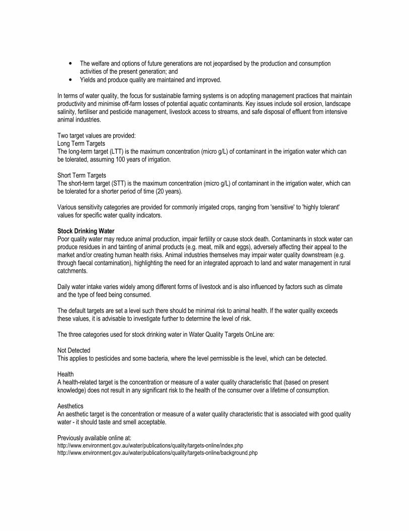
Human Use Nitrogen Water Quality Guidelines
Environmental Value Category Ammonia (NH3) Nitrate (NO3) Nitrite (NO2) Total Nitrogen (TN)
Recreation - Primary Contact 10 micro g N /L 44 300 micro g /L converted to nitrate
3 280 micro g /L converted to nitrite
Recreation - Secondary Contact 10 micro g N /L 44 300 micro g /L converted to nitrate
3 280 micro g /L converted to nitrite
Recreation - Visual Appreciation (no contact) Not Applicable Not Applicable Not Applicable
Drinking Water (DW)/ Health Value Not specified 50 000 micro g/L as Nitrate 3 000 micro g/L as Nitrite
DW Aesthetic Value (Taste & Odour) 500 micro g/L Not Specified Not Specified
Aquaculture /Human consumption aquatic food <20 micro g/L (pH >8.0) coldwater; <30 micro g/L warmwater
<50 000 micro g/L <100 micro g/L
Irrigation Long Term Targets 5 000 micro g/L
Irrigation Short Term Targets 25 000 -125 000 micro g/L STT *
Livestock Drinking Water (LDW) Health Value < 400 000 micro g /L (1 500 000 micro g /L toxic)
<30 000 micro g/L
Note: Values are for Tropical Queensland Rivers Upland and Lowland as well as Wetlands (Lakes and Reservoirs)
Aquatic Ecosystem Nitrogen Water Quality Guidelines
Aquatic Ecosystem Protection Oxides of Nitrogen (NOx) Total Nitrogen (TN)
Upland 30 micro g N /L 150 micro g /L
Lowland 10 micro g N /L Rainforest 200 micro g /L; OTHER-300 micro g /L
Wetlands, Lakes and Reservoirs 10 micro g N /L 350 micro g /L for turbid lakes only; Clear lakes have lower values Note: *site-specific assessment needed. Nitrate (NO3) and Ammonia (NH3) can be toxicants to the flora and fauna of an ecosystem. Toxicity is determined by tests on specific organisms. The values provided are for specific levels of aquatic ecosystem protection. The default targets where the Environmental Value selected is Aquatic Ecosystem Protection assume that the ecosystem is slightly to moderately disturbed. Where the system is highly disturbed, the same values can be used as default targets. Where, however, the system is of high conservation value and/or essentially undisturbed, the target set should ensure there will be no detectable change from natural variation. For Irrigation: Long Term Targets - those that should allow no deterioration in 100 years of use and Short Term Targets - should allow no deterioration within 20 years of use. It is preferable to use the Long Term Targets.

Human Use Phosphorus Water Quality Guidelines
Environmental Value Category Phosphates Phosphorus - Total
Aquaculture /Human consumption aquatic food <100 micro g/L
Irrigation Long Term Targets 50 micro g/L
Irrigation Short Term Targets 800-12 000 micro g/L STT * Note: Values are for Tropical Queensland Rivers Upland and Lowland as well as Wetlands (Lakes and Reservoirs)
Aquatic Ecosystems Phosphorus Water Quality Guidelines
Aquatic Ecosystem Protection Filterable Reactive Phosphate (FRP) Phosphorus - Total
Upland 5 micro g P /L 10 micro g /L
Lowland 4 micro g P /L 10 micro g /L
Wetlands, Lakes and Reservoirs 5 micro g P /L 10 micro g /L Note: The default targets where the Environmental Value selected is Aquatic Ecosystem Protection assume that the ecosystem is slightly to moderately disturbed. Where the system is highly disturbed, the same values can be used as default targets. Where, however, the system is of high conservation value and/or essentially undisturbed, the target set should ensure there will be no detectable change from natural variation. * indicates site-specific assessment needed.

Human Use Turbidity Water Quality Guidelines
Environmental Value Category Colour and appearance of water Turbidity/Suspended Solids Natural Reflectance
Recreation - Primary Contact Not Applicable
For swimming Secchi disk (200mm diameter) sighted horizontally >1.6m
Not Applicable
Recreation - Secondary Contact Not Applicable Not Applicable Not Applicable
Recreation - Visual Appreciation (no contact)
The natural hue of water should not be changed by more than 10 points on Munsell Scale
Natural visual clarity not reduced by more than 20%
Natural reflectance not changed by more than 50%
Drinking Water Aesthetic Value (Taste & Odour)
5 NTU
Aquaculture/Human consumption aquatic food - Freshwater
30-40 (Pt-Co units) <40 000 micro g/L
Note: Values are for Tropical Queensland Rivers Upland and Lowland as well as Wetlands (Lakes and Reservoirs)
Aquatic Ecosystem Turbidity Water Quality Guidelines
Aquatic Ecosystem Protection Turbidity/Suspended Solids
Rivers 2-15 NTU
Wetlands, Lakes and Reservoirs 2-200 NTU - Low in deep lakes; High in shallow lakes; depends on geology, often wind induced Note: Low values typical of NT base flow; QLD values variable, depend on catchment changes & seasonal runoff. The default targets where the Environmental Value selected is Aquatic Ecosystem Protection assume that the ecosystem is slightly to moderately disturbed. Where the system is highly disturbed, the same values can be used as default targets. Where, however, the system is of high conservation value and/or essentially undisturbed, the target set should ensure there will be no detectable change from natural variation.
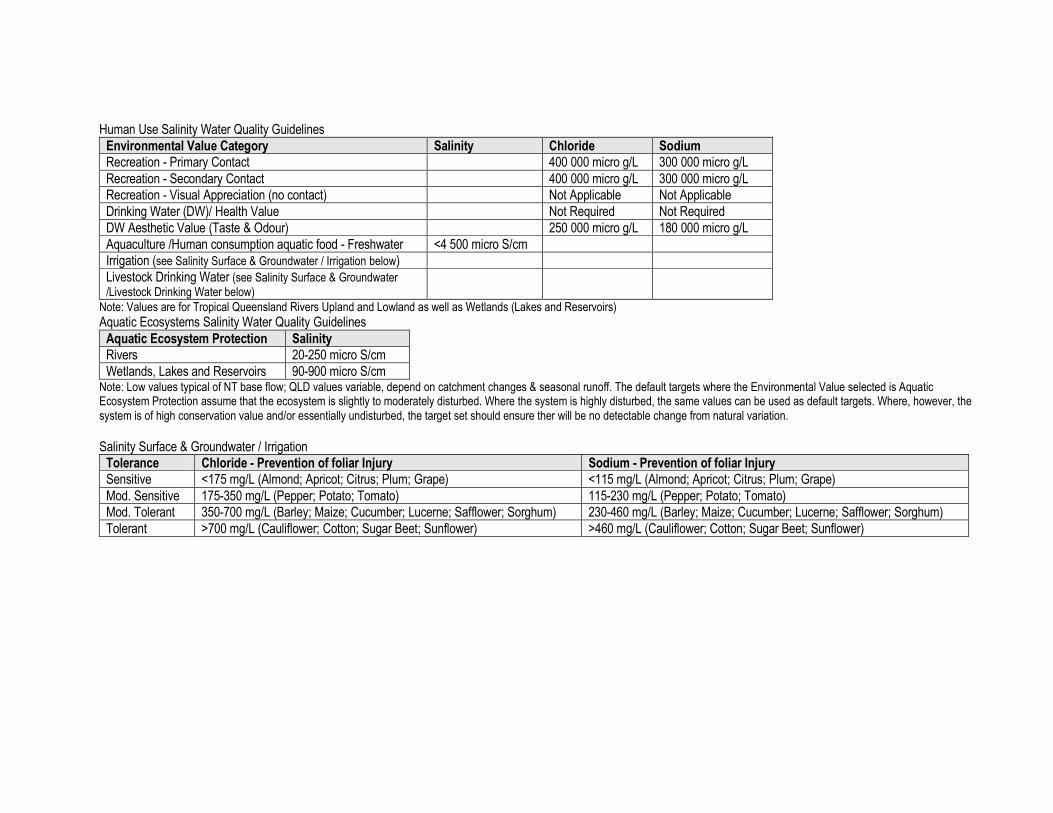
Human Use Salinity Water Quality Guidelines
Environmental Value Category Salinity Chloride Sodium
Recreation - Primary Contact 400 000 micro g/L 300 000 micro g/L
Recreation - Secondary Contact 400 000 micro g/L 300 000 micro g/L
Recreation - Visual Appreciation (no contact) Not Applicable Not Applicable
Drinking Water (DW)/ Health Value Not Required Not Required
DW Aesthetic Value (Taste & Odour) 250 000 micro g/L 180 000 micro g/L
Aquaculture /Human consumption aquatic food - Freshwater <4 500 micro S/cm
Irrigation (see Salinity Surface & Groundwater / Irrigation below)
Livestock Drinking Water (see Salinity Surface & Groundwater /Livestock Drinking Water below)
Note: Values are for Tropical Queensland Rivers Upland and Lowland as well as Wetlands (Lakes and Reservoirs)
Aquatic Ecosystems Salinity Water Quality Guidelines
Aquatic Ecosystem Protection Salinity
Rivers 20-250 micro S/cm
Wetlands, Lakes and Reservoirs 90-900 micro S/cm Note: Low values typical of NT base flow; QLD values variable, depend on catchment changes & seasonal runoff. The default targets where the Environmental Value selected is Aquatic Ecosystem Protection assume that the ecosystem is slightly to moderately disturbed. Where the system is highly disturbed, the same values can be used as default targets. Where, however, the system is of high conservation value and/or essentially undisturbed, the target set should ensure ther will be no detectable change from natural variation.
Salinity Surface & Groundwater / Irrigation
Tolerance Chloride - Prevention of foliar Injury Sodium - Prevention of foliar Injury
Sensitive <175 mg/L (Almond; Apricot; Citrus; Plum; Grape) <115 mg/L (Almond; Apricot; Citrus; Plum; Grape)
Mod. Sensitive 175-350 mg/L (Pepper; Potato; Tomato) 115-230 mg/L (Pepper; Potato; Tomato)
Mod. Tolerant 350-700 mg/L (Barley; Maize; Cucumber; Lucerne; Safflower; Sorghum) 230-460 mg/L (Barley; Maize; Cucumber; Lucerne; Safflower; Sorghum)
Tolerant >700 mg/L (Cauliflower; Cotton; Sugar Beet; Sunflower) >460 mg/L (Cauliflower; Cotton; Sugar Beet; Sunflower)

Salinity Surface & Groundwater / Livestock Drinking Water:
Impact Beef Cattle Dairy Cattle Sheep
Initial Effect <6 000 micro S/cm no effect <3 700 micro S/cm no effect <7 400 micro S/cm no effect
Moderate Effect 6 000 -7 400 micro S/cm 3 700 - 6 000 micro S/cm 7 400 -15 000 micro S/cm
Major Effect 7 400 - 15 000 micro S/cm 6 000 - 10 400 micro S/cm 15 000 -19 400 micro S/cm
Impact Horses Pigs Poultry
Initial Effect <6 000 micro S/cm no effect <6 000 micro S/cm no effect <3 000 micro S/cm no effect
Moderate Effect 6 000 - 9 000 micro S/cm 6 000 - 9 000 micro S/cm 3 000 - 4 500 micro S/cm
Major Effect 9 000 - 10 400 micro S/cm 9 000 - 12 000 micro S/cm 4 500 - 6 000 micro S/cm Note: Initial Effect = no effect, Moderate Effect = reluctance to drink + scouring, Major Effect = loss of production & condition
Estuaries and Marine Waters Marine Human Use Nitrogen Water Quality Guidelines
Human Use Environmental Value Ammonia (NH3) Nitrate (NO3) Nitrite (NO2)
Recreation - Primary Contact 10 micro g N /L 44 300 micro g /L converted to nitrate 3 280 micro g /L converted to nitrite
Recreation - Secondary Contact 10 micro g N /L 44 300 micro g /L converted to nitrate 3 280 micro g /L converted to nitrite
Recreation - Visual Appreciation (no contact) Not Applicable Not Applicable Not Applicable
Aquaculture /Human consumption of aquatic food <100 micro g/L <100 000 micro g/L <100 micro g/L Note: Values are for Tropical Queensland estuaries and marine waters (inshore and offshore)
Marine Aquatic Ecosystem Nitrogen Water Quality Guidelines
Aquatic Ecosystem Protection Oxides of Nitrogen (NOx) Total Nitrogen (TN)
Estuaries 30 micro g N /L 250 micro g /L
Marine Inshore Coral Reef- 2 micro g N /L; OTHER- 8 micro g N/L 100 micro g /L
Marine Offshore Coral Reef- 1 micro g N /L ;OTHER- 4 micro g N /L 100 micro g /L Note: Nitrate (NO3) and Ammonia (NH3) can be toxicants to the flora and fauna of an ecosystem. Toxicity is determined by tests on specific organisms. The values provided are for specific levels of aquatic ecosystem protection. The default targets where the Environmental Value selected is Aquatic Ecosystem Protection assume that the ecosystem is slightly to moderately disturbed. Where the system is highly disturbed, the same values can be used as default targets. Where, however, the system is of high conservation value and/or essentially undisturbed, the target set should ensure there will be no detectable change from natural variation.

Marine Human Use Phosphorus Water Quality Guidelines
Human Use Environmental Value Phosphates
Aquaculture /Human consumption of aquatic food <50 micro g/L Note: Values are for Tropical Queensland estuaries and marine (inshore and offshore).
Marine Aquatic Ecosystems Phosphorus Water Quality Guidelines
Aquatic Ecosystem Protection Filterable Reactive Phosphate (FRP) Phosphorus - Total
Estuaries 5 micro g P /L 20 micro g /L
Marine Inshore 5 micro g P /L 15 micro g /L
Marine Offshore Coral Reef- 2 micro g P /L; Other- 5 micro g P /L 10 micro g /L Note: Values are for Tropical Queensland estuaries and marine waters (inshore and offshore). The default targets where the Environmental Value selected is Aquatic Ecosystem Protection assume that the ecosystem is slightly to moderately disturbed. Where the system is highly disturbed, the same values can be used as default targets. Where, however, the system is of high conservation value and/or essentially undisturbed, the target set should ensure there will be no detectable change from natural variation.
Marine Human Use and Aquatic Ecosystem Turbidity Water Quality Guidelines
Environmental Value Category Colour and appearance of water Turbidity/Suspended Solids Natural Reflectance
Recreation - Primary Contact Not Applicable
For swimming Secchi disk (200mm diameter) sighted horizontally >1.6m
Not Applicable
Recreation - Secondary Contact Not Applicable Not Applicable Not Applicable
Recreation - Visual Appreciation (no contact)
The natural hue of water should not be changed by more than 10 points on Munsell Scale
Natural visual clarity not reduced by more than 20%
Natural reflectance not changed by more than 50%
Aquaculture /Human consumption aquatic food - Marine
30-40 (Pt-Co units) <10 000 micro g/L (<75 000 micro g/L Brackish)
Aquatic Ecosystem Protection 1-20 NTU - Low values: offshore, coral dominated waters; High values: estuaries
Note: Values are for Tropical Queensland estuaries and marine waters (inshore and offshore). The default targets where the Environmental Value selected is Aquatic Ecosystem Protection assume that the ecosystem is slightly to moderately disturbed. Where the system is highly disturbed, the same values can be used as default targets. Where, however, the system is of high conservation value and/or essentially undisturbed, the target set should ensure there will be no detectable change from natural variation.
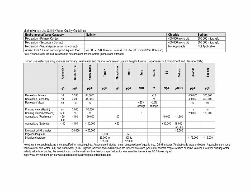
Marine Human Use Salinity Water Quality Guidelines
Environmental Value Category Salinity Chloride Sodium
Recreation - Primary Contact 400 000 micro g/L 300 000 micro g/L
Recreation - Secondary Contact 400 000 micro g/L 300 000 micro g/L
Recreation - Visual Appreciation (no contact) Not Applicable Not Applicable
Aquaculture /Human consumption aquatic food 49 000 - 55 000 micro S/cm (4 500 - 52 000 micro S/cm Brackish) Note: Values are for Tropical Queensland estuaries and marine waters (inshore and offshore).
Human use water quality guidelines summary (freshwater and marine from Water Quality Targets Online (Department of Environment and Heritage 2002)
Ammonia N
Nitrite NO2 N
Nitrate NO3 N
Total N
Phosphates
Total P
Turb
Secchi
SS
Salinity
Chloride
Sodium
µµµµg/L µµµµg/L µµµµg/L µµµµg/L µµµµg/L µµµµg/L NTU m mg/L µµµµS/cm µµµµg/L µµµµg/L
Recreation Primary 10 3,280 44,3000 >1.6 400,000 300,000
Recreation Secondary 10 3,280 44,3000 na 400,000 300,000
Recreation Visual na na na <20% change
<20% change
na na
Drinking water (Health) ns 3,000 50,000 nr nr
Drinking water (Aesthetics) 500 ns ns 5 250,000 180,000
Aquaculture (Freshwater) <20 <30
<100 <50,000 100 40,000 <4,500
Aquaculture (Saltwater) <100 <100 <100,000 <50 <10,000 49,000 - 55,000
Livestock drinking water <30,000 <400,000 <3,000
Irrigation long term 5,000 50
Irrigation short term 25,000 to 125,000
800 to 12,000
<175,000 <115,000
Notes: na is not applicable, ns is not specified, nr is not required. Aquaculture includes human consumption of aquatic food. Drinking water (Aesthetics) is taste and odour. Aquaculture ammonia values are for cold water (<20) and warm water (<30). Irrigation Chloride and Sodium vales are for sensitive crops (values for tolerant crops 4-5 times sensitive values). Livestock drinking water salinity value is for poultry, the lowest impact on the most sensitive livestock type (values for less sensitive livestock are 2-2.5 times higher) http://www.environment.gov.au/water/publications/quality/targets-online/index.php
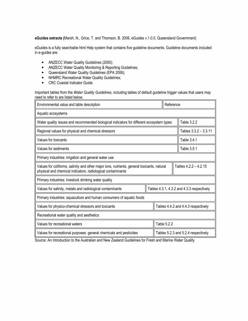
eGuides extracts (Marsh, N., Grice, T. and Thomson, B. 2006, eGuides v.1.0.0, Queensland Government) eGuides is a fully searchable html Help system that contains five guideline documents. Guideline documents included in e-guides are:
• ANZECC Water Quality Guidelines (2000);
• ANZECC Water Quality Monitoring & Reporting Guidelines;
• Queensland Water Quality Guidelines (EPA 2006);
• NHMRC Recreational Water Quality Guidelines;
• CRC Coastal Indicator Guide. Important tables from the Water Quality Guidelines, including tables of default guideline trigger values that users may need to refer to are listed below.
Environmental value and table description Reference
Aquatic ecosystems
Water quality issues and recommended biological indicators for different ecosystem types Table 3.2.2
Regional values for physical and chemical stressors Tables 3.3.2 – 3.3.11
Values for toxicants Table 3.4.1
Values for sediments Table 3.5.1
Primary industries: irrigation and general water use
Values for coliforms, salinity and other major ions, nutrients, general toxicants, natural physical and chemical indicators, radiological contaminants
Tables 4.2.2 – 4.2.15
Primary industries: livestock drinking water quality
Values for salinity, metals and radiological contaminants Tables 4.3.1, 4.3.2 and 4.3.3 respectively
Primary industries: aquaculture and human consumers of aquatic foods
Values for physico-chemical stressors and toxicants Tables 4.4.2 and 4.4.3 respectively
Recreational water quality and aesthetics
Values for recreational waters Table 5.2.2
Values for recreational purposes: general chemicals and pesticides Tables 5.2.3 and 5.2.4 respectively
Source: An Introduction to the Australian and New Zealand Guidelines for Fresh and Marine Water Quality
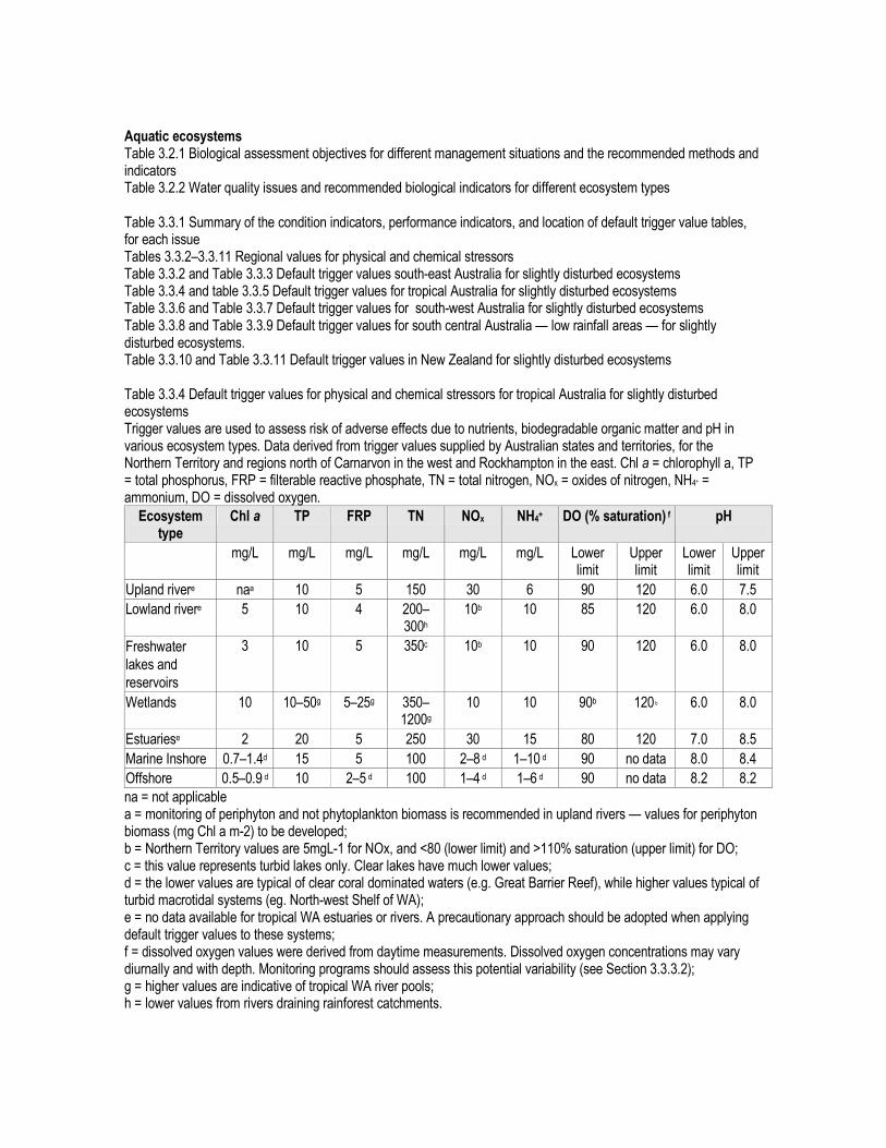
Aquatic ecosystems Table 3.2.1 Biological assessment objectives for different management situations and the recommended methods and indicators Table 3.2.2 Water quality issues and recommended biological indicators for different ecosystem types Table 3.3.1 Summary of the condition indicators, performance indicators, and location of default trigger value tables, for each issue Tables 3.3.2–3.3.11 Regional values for physical and chemical stressors Table 3.3.2 and Table 3.3.3 Default trigger values south-east Australia for slightly disturbed ecosystems Table 3.3.4 and table 3.3.5 Default trigger values for tropical Australia for slightly disturbed ecosystems Table 3.3.6 and Table 3.3.7 Default trigger values for south-west Australia for slightly disturbed ecosystems Table 3.3.8 and Table 3.3.9 Default trigger values for south central Australia — low rainfall areas — for slightly disturbed ecosystems. Table 3.3.10 and Table 3.3.11 Default trigger values in New Zealand for slightly disturbed ecosystems Table 3.3.4 Default trigger values for physical and chemical stressors for tropical Australia for slightly disturbed ecosystems Trigger values are used to assess risk of adverse effects due to nutrients, biodegradable organic matter and pH in various ecosystem types. Data derived from trigger values supplied by Australian states and territories, for the Northern Territory and regions north of Carnarvon in the west and Rockhampton in the east. Chl a = chlorophyll a, TP = total phosphorus, FRP = filterable reactive phosphate, TN = total nitrogen, NOx = oxides of nitrogen, NH4+ = ammonium, DO = dissolved oxygen.
Ecosystem type
Chl a TP FRP TN NOx NH4+ DO (% saturation) f pH
mg/L mg/L mg/L mg/L mg/L mg/L Lower limit
Upper limit
Lower limit
Upper limit
Upland rivere naa 10 5 150 30 6 90 120 6.0 7.5
Lowland rivere 5 10 4 200– 300h
10b 10 85 120 6.0 8.0
Freshwater
lakes and
reservoirs
3 10 5 350c 10b 10 90 120 6.0 8.0
Wetlands 10 10–50g 5–25g 350–1200g
10 10 90b 120 b 6.0 8.0
Estuariese 2 20 5 250 30 15 80 120 7.0 8.5
Marine Inshore 0.7–1.4d 15 5 100 2–8 d 1–10 d 90 no data 8.0 8.4
Offshore 0.5–0.9 d 10 2–5 d 100 1–4 d 1–6 d 90 no data 8.2 8.2
na = not applicable a = monitoring of periphyton and not phytoplankton biomass is recommended in upland rivers — values for periphyton biomass (mg Chl a m-2) to be developed; b = Northern Territory values are 5mgL-1 for NOx, and <80 (lower limit) and >110% saturation (upper limit) for DO; c = this value represents turbid lakes only. Clear lakes have much lower values; d = the lower values are typical of clear coral dominated waters (e.g. Great Barrier Reef), while higher values typical of turbid macrotidal systems (eg. North-west Shelf of WA); e = no data available for tropical WA estuaries or rivers. A precautionary approach should be adopted when applying default trigger values to these systems; f = dissolved oxygen values were derived from daytime measurements. Dissolved oxygen concentrations may vary diurnally and with depth. Monitoring programs should assess this potential variability (see Section 3.3.3.2); g = higher values are indicative of tropical WA river pools; h = lower values from rivers draining rainforest catchments.

Table 3.3.5 Ranges of default trigger values for conductivity (EC, salinity), turbidity and suspended particulate matter (SPM) indicative of slightly disturbed ecosystems in tropical Australia. Ranges for turbidity and SPM are similar and only turbidity is reported here. Values reflect high site-specific and regional variability. Explanatory notes provide detail on specific variability issues for groupings of ecosystem type.
Ecosystem type Salinity (mScm-1) Explanatory notes Upland & lowland rivers
20–250 Conductivity in upland streams will vary depending upon catchment geology. Values at the lower end of the range are typical of ephemeral flowing NT rivers. Catchment type may influence values for Qld lowland rivers (e.g. 150 mScm-1 for rivers draining rainforest catchments, 250 mScm-1 for savanna catchments). The first flush of water following early seasonal rains may result in temporarily high values.
Lakes, reservoirs & wetlands
90–900 Values at the lower end of the range are found in permanent billabongs in the NT. Higher conductivity values will occur during summer when water levels are reduced due to evaporation. WA wetlands can have values higher than 900 mScm-1. Turbid freshwater lakes in Qld have reported conductivities of approx. 170 mScm-1.
Turbidity (NTU) Upland & lowland rivers
2–15 Low values for base flow conditions in NT rivers. QLD turbidity and SPM values highly variable and dependent on degree of catchment modification and seasonal rainfall runoff.
Lakes, reservoirs & wetlands
2–200 Most deep lakes and reservoirs have low turbidity. However, shallow lakes and reservoirs may have higher turbidity naturally due to wind-induced resuspension of sediments. Lakes and reservoirs in catchments with highly dispersible soils will have high turbidity. Wetlands vary greatly in turbidity depending upon the general condition of the catchment or river system draining into the wetland, recent flow events and the water level in the wetland.
Estuarine & marine
1–20 Low values indicative of offshore coral dominated waters. Higher values representative of estuarine waters. Turbidity is not a very useful indicator in estuarine and marine waters. A move towards the measurement of light attenuation in preference to turbidity is recommended. Typical light attenuation coefficients (log10) in waters off north-west WA range from 0.17 for inshore waters to 0.07 for offshore waters.

Table 3.4.1 Trigger values for toxicants at alternative levels of protection (aquatic ecosystems) Part 1
Chemical Trigger values for freshwater (µgL-1)
Trigger values for marine water (µgL-1)
Level of protection (% species) Level of protection (% species)
99% 95% 90% 80% 99% 95% 90% 80%
METALS & METALLOIDS
Aluminium pH >6.5 27 55 80 150 ID ID ID ID
Aluminium pH <6.5 ID ID ID ID ID ID ID ID
Antimony ID ID ID ID ID ID ID ID
Arsenic (As III) 1 24 94 360 ID ID ID ID
Arsenic (AsV) 0.8 13 42 140 ID ID ID ID
Beryllium ID ID ID ID ID ID ID ID
Bismuth ID ID ID ID ID ID ID ID
Boron 90 370 680 1300 ID ID ID ID
Cadmium 0.06 0.2 0.4 0.8 0.7 5.5 14 36
Chromium (Cr III) ID ID ID ID 7.7 27.4 48.6 90.6
Chromium (CrVI) 0.01 1.0 6 40 0.14 4.4 20 85
Cobalt ID ID ID ID 0.005 1 14 150
Copper 1.0 1.4 1.8 2.5 0.3 1.3 3 8
Gallium ID ID ID ID ID ID ID ID
Iron ID ID ID ID ID ID ID ID
Lanthanum ID ID ID ID ID ID ID ID
Lead 1.0 3.4 5.6 9.4 2.2 4.4 6.6 12
Manganese 1200 1900 2500 3600 ID ID ID ID
Mercury (inorganic) 0.06 0.6 1.9 5.4 0.1 0.4 0.7 1.4
Mercury (methyl) ID ID ID ID ID ID ID ID
Molybdenum ID ID ID ID ID ID ID ID
Nickel 8 11 13 17 7 70 200 560
Selenium (Total) 5 11 18 34 ID ID ID ID
Selenium (SeIV) ID ID ID ID ID ID ID ID
Silver 0.02 0.05 0.1 0.2 0.8 1.4 1.8 2.6
Thallium ID ID ID ID ID ID ID ID
Tin (inorganic, SnIV) ID ID ID ID ID ID ID ID
Tributyltin (as mg/L Sn) ID ID ID ID 0.0004 0.006 0.02 0.05
Uranium ID ID ID ID ID ID ID ID
Vanadium ID ID ID ID 50 100 160 280
Zinc 2.4 8.0 15 31 7 15 23 43
Notes: Where the final water quality guideline to be applied to a site is below current analytical practical quantitation limits, see Section 3.4.3.3 for guidance. Values in blue shading are the trigger values applying to typical slightly–moderately disturbed systems; see Table 3.4.2 General framework for applying levels of protection for toxicants to different ecosystem conditions (aquatic ecosystems) and section 3.4.2.4 for guidance on applying these levels to different ecosystem conditions.

Most trigger values listed here for metals and metalloids are High reliability figures, derived from field or chronic NOEC data (see 3.4.2.3 for reference to Volume 2). The exceptions are Moderate reliability for freshwater aluminium (pH >6.5), manganese and marine chromium (III). Part 2
Chemical Trigger values for freshwater (µgL-1) Trigger values for marine water (µgL-1)
Level of protection (% species) Level of protection (% species) 99% 95% 90% 80% 99% 95% 90% 80% Non-metallic Inorganics
Ammonia 320 900 1430 2300 500 910 1200 1700 Chlorine 0.4 3 6 13 ID ID ID ID Cyanide 4 7 11 18 2 4 7 14 Nitrate **** 17 700 3400 17000 ID ID ID ID Hydrogen sulfide 0.5 1.0 1.5 2.6 ID ID ID ID Organic Alcohols Ethanol 400 1400 2400 4000 ID ID ID ID
Ethylene glycol ID ID ID ID ID ID ID ID Isopropyl alcohol ID ID ID ID ID ID ID ID Chlorinated Alkanes Chloromethanes
Dichloromethane ID ID ID ID ID ID ID ID Chloroform ID ID ID ID ID ID ID ID Carbon tetrachloride ID ID ID ID ID ID ID ID Chloroethanes 1,2-dichloroethane ID ID ID ID ID ID ID ID 1,1,1-trichloroethane ID ID ID ID ID ID ID ID 1,1,2-trichloroethane 5400 6500 7300 8400 140 1900 5800 18000
1,1,2,2-tetrachloroethane ID ID ID ID ID ID ID ID Pentachloroethane ID ID ID ID ID ID ID ID Hexachloroethane 290 360 420 500 ID ID ID ID Chloropropanes
1,1-dichloropropane ID ID ID ID ID ID ID ID 1,2-dichloropropane ID ID ID ID ID ID ID ID 1,3-dichloropropane ID ID ID ID ID ID ID ID Chlorinated Alkenes Chloroethylene ID ID ID ID ID ID ID ID 1,1-dichloroethylene ID ID ID ID ID ID ID ID 1,1,2-trichloroethylene ID ID ID ID ID ID ID ID
1,1,2,2-tetrachloroethylene ID ID ID ID ID ID ID ID 3-chloropropene ID ID ID ID ID ID ID ID 1,3-dichloropropene ID ID ID ID ID ID ID ID
**** Please see Amendment to ANZECC for further development of the Nitrates guideline trigger values Notes: Where the final water quality guideline to be applied to a site is below current analytical practical quantitation limits, see Section 3.4.3.3 for guidance. Values in blue shading are the trigger values applying to typical slightly–moderately disturbed systems; see Table 3.4.2 General framework for applying levels of protection for toxicants to different ecosystem conditions (aquatic ecosystems) and section 3.4.2.4 for guidance on applying these levels to different ecosystem conditions. Most trigger values listed here for non-metallic inorganics and organic chemicals are Moderate reliability figures, derived from acute LC50 data (see 3.4.2.3 for reference to Volume 2). The exceptions are High reliability for freshwater ammonia, 3,4-DCA, endosulfan, chlorpyrifos, esfenvalerate, tebuthiuron, three surfactants and marine for 1,1,2-TCE and chlorpyrifos.
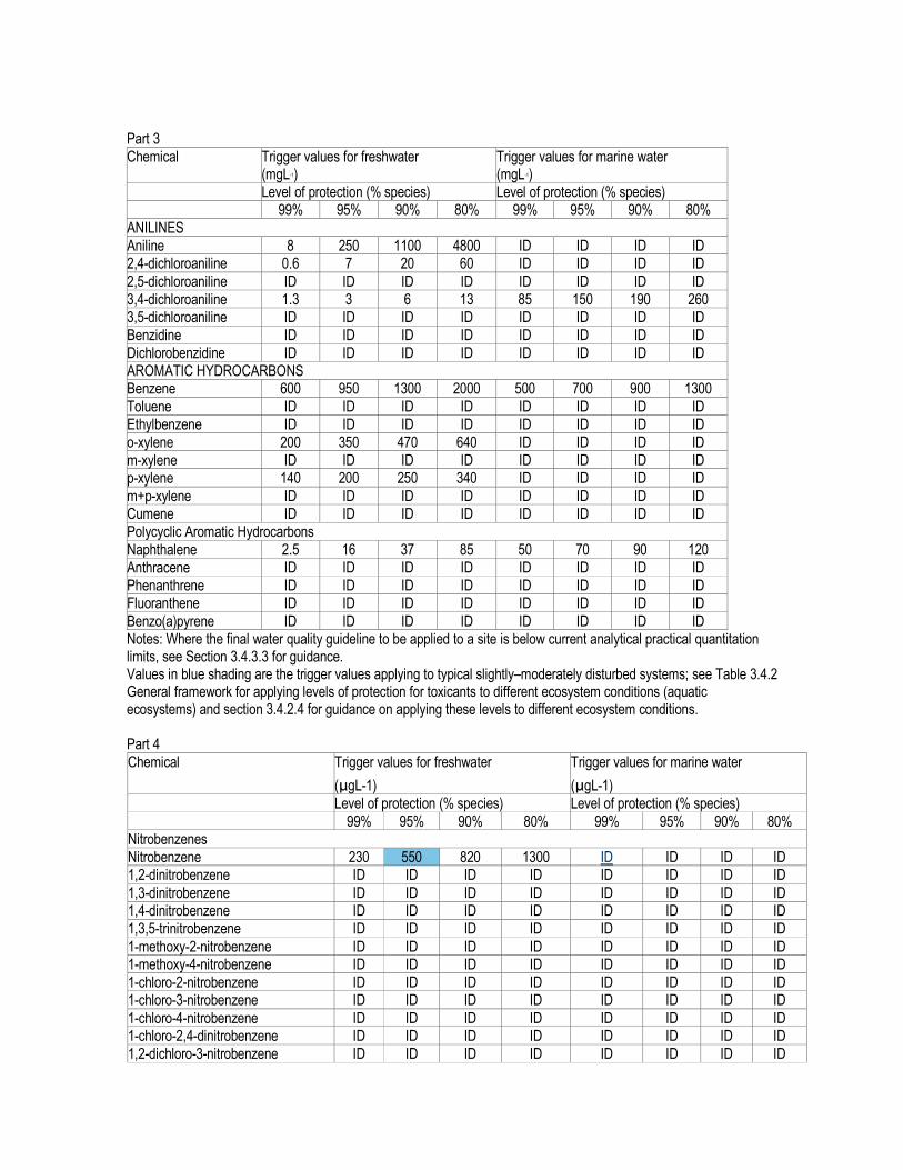
Part 3 Chemical Trigger values for freshwater
(mgL-1) Trigger values for marine water (mgL-1)
Level of protection (% species) Level of protection (% species) 99% 95% 90% 80% 99% 95% 90% 80% ANILINES Aniline 8 250 1100 4800 ID ID ID ID 2,4-dichloroaniline 0.6 7 20 60 ID ID ID ID
2,5-dichloroaniline ID ID ID ID ID ID ID ID 3,4-dichloroaniline 1.3 3 6 13 85 150 190 260 3,5-dichloroaniline ID ID ID ID ID ID ID ID Benzidine ID ID ID ID ID ID ID ID Dichlorobenzidine ID ID ID ID ID ID ID ID AROMATIC HYDROCARBONS Benzene 600 950 1300 2000 500 700 900 1300 Toluene ID ID ID ID ID ID ID ID Ethylbenzene ID ID ID ID ID ID ID ID o-xylene 200 350 470 640 ID ID ID ID m-xylene ID ID ID ID ID ID ID ID p-xylene 140 200 250 340 ID ID ID ID
m+p-xylene ID ID ID ID ID ID ID ID Cumene ID ID ID ID ID ID ID ID Polycyclic Aromatic Hydrocarbons Naphthalene 2.5 16 37 85 50 70 90 120 Anthracene ID ID ID ID ID ID ID ID Phenanthrene ID ID ID ID ID ID ID ID Fluoranthene ID ID ID ID ID ID ID ID
Benzo(a)pyrene ID ID ID ID ID ID ID ID Notes: Where the final water quality guideline to be applied to a site is below current analytical practical quantitation limits, see Section 3.4.3.3 for guidance. Values in blue shading are the trigger values applying to typical slightly–moderately disturbed systems; see Table 3.4.2 General framework for applying levels of protection for toxicants to different ecosystem conditions (aquatic ecosystems) and section 3.4.2.4 for guidance on applying these levels to different ecosystem conditions. Part 4 Chemical Trigger values for freshwater
(µgL-1)
Trigger values for marine water
(µgL-1) Level of protection (% species) Level of protection (% species)
99% 95% 90% 80% 99% 95% 90% 80% Nitrobenzenes Nitrobenzene 230 550 820 1300 ID ID ID ID 1,2-dinitrobenzene ID ID ID ID ID ID ID ID
1,3-dinitrobenzene ID ID ID ID ID ID ID ID 1,4-dinitrobenzene ID ID ID ID ID ID ID ID 1,3,5-trinitrobenzene ID ID ID ID ID ID ID ID
1-methoxy-2-nitrobenzene ID ID ID ID ID ID ID ID 1-methoxy-4-nitrobenzene ID ID ID ID ID ID ID ID 1-chloro-2-nitrobenzene ID ID ID ID ID ID ID ID 1-chloro-3-nitrobenzene ID ID ID ID ID ID ID ID
1-chloro-4-nitrobenzene ID ID ID ID ID ID ID ID 1-chloro-2,4-dinitrobenzene ID ID ID ID ID ID ID ID 1,2-dichloro-3-nitrobenzene ID ID ID ID ID ID ID ID

1,3-dichloro-5-nitrobenzene ID ID ID ID ID ID ID ID 1,4-dichloro-2-nitrobenzene ID ID ID ID ID ID ID ID 2,4-dichloro-2-nitrobenzene ID ID ID ID ID ID ID ID 1,2,4,5-tetrachloro-3-nitrobenzene ID ID ID ID ID ID ID ID 1,5-dichloro-2,4-dinitrobenzene ID ID ID ID ID ID ID ID 1,3,5-trichloro-2,4-dinitrobenzene ID ID ID ID ID ID ID ID 1-fluoro-4-nitrobenzene ID ID ID ID ID ID ID ID Nitrotoluenes
2-nitrotoluene ID ID ID ID ID ID ID ID 3-nitrotoluene ID ID ID ID ID ID ID ID 4-nitrotoluene ID ID ID ID ID ID ID ID 2,3-dinitrotoluene ID ID ID ID ID ID ID ID 2,4-dinitrotoluene 16 65 130 250 ID ID ID ID 2,4,6-trinitrotoluene 100 140 160 210 ID ID ID ID 1,2-dimethyl-3-nitrobenzene ID ID ID ID ID ID ID ID
1,2-dimethyl-4-nitrobenzene ID ID ID ID ID ID ID ID 4-chloro-3-nitrotoluene ID ID ID ID ID ID ID ID Notes: Where the final water quality guideline to be applied to a site is below current analytical practical quantitation limits, see Section 3.4.3.3 for guidance. Values in blue shading are the trigger values applying to typical slightly–moderately disturbed systems; see Table 3.4.2 General framework for applying levels of protection for toxicants to different ecosystem conditions (aquatic ecosystems) and section 3.4.2.4 for guidance on applying these levels to different ecosystem conditions. Part 5 Chemical Trigger values for freshwater
(µgL-1)
Trigger values for marine water
(µgL-1)
Level of protection (% species) Level of protection (% species) 99% 95% 90% 80% 99% 95% 90% 80% Chlorobenzenes and Chloronaphthalenes Monochlorobenzene ID ID ID ID ID ID ID ID
1,2-dichlorobenzene 120 160 200 270 ID ID ID ID 1,3-dichlorobenzene 160 260 350 520 ID ID ID ID 1,4-dichlorobenzene 40 60 75 100 ID ID ID ID 1,2,3-trichlorobenzene 3 10 16 30 ID ID ID ID 1,2,4-trichlorobenzene 85 170 220 300 20 80 140 240 1,3,5-trichlorobenzene ID ID ID ID ID ID ID ID 1,2,3,4-tetrachlorobenzene ID ID ID ID ID ID ID ID
1,2,3,5-tetrachlorobenzene ID ID ID ID ID ID ID ID 1,2,4,5-tetrachlorobenzene ID ID ID ID ID ID ID ID Pentachlorobenzene ID ID ID ID ID ID ID ID Hexachlorobenzene ID ID ID ID ID ID ID ID 1-chloronaphthalene ID ID ID ID ID ID ID ID Polychlorinated Biphenyls (PCBs) & Dioxins Capacitor 21 ID ID ID ID ID ID ID ID Aroclor 1016 ID ID ID ID ID ID ID ID Aroclor 1221 ID ID ID ID ID ID ID ID Aroclor 1232 ID ID ID ID ID ID ID ID Aroclor 1242 0.3 0.6 1.0 1.7 ID ID ID ID Aroclor 1248 ID ID ID ID ID ID ID ID
Aroclor 1254 0.01 0.03 0.07 0.2 ID ID ID ID Aroclor 1260 ID ID ID ID ID ID ID ID Aroclor 1262 ID ID ID ID ID ID ID ID

Aroclor 1268 ID ID ID ID ID ID ID ID 2,3,4'-trichlorobiphenyl ID ID ID ID ID ID ID ID 4,4'-dichlorobiphenyl ID ID ID ID ID ID ID ID 2,2',4,5,5'-pentachloro-1,1'-biphenyl
ID ID ID ID ID ID ID ID
2,4,6,2',4',6'-hexachlorobiphenyl ID ID ID ID ID ID ID ID Total PCBs ID ID ID ID ID ID ID ID 2,3,7,8-TCDD ID ID ID ID ID ID ID ID
Notes: Where the final water quality guideline to be applied to a site is below current analyticalpractical quantitation limits, see Section 3.4.3.3 for guidance. Values in blue shading are the trigger values applying to typical slightly–moderately disturbed systems; see Table 3.4.2 General framework for applying levels of protection for toxicants to different ecosystem conditions (aquatic ecosystems) and section 3.4.2.4 for guidance on applying these levels to different ecosystem conditions. Part 6 Chemical Trigger values for freshwater
(mgL-1) Trigger values for marine water (mgL-1)
Level of protection (% species) Level of protection (% species) 99% 95% 90% 80% 99% 95% 90% 80% PHENOLS and XYLENOLS Phenol 85 320 600 1200 270 400 520 720
2,4-dimethylphenol ID ID ID ID ID ID ID ID Nonylphenol ID ID ID ID ID ID ID ID 2-chlorophenol 340 490 630 870 ID ID ID ID 3-chlorophenol ID ID ID ID ID ID ID ID 4-chlorophenol 160 220 280 360 ID ID ID ID 2,3-dichlorophenol ID ID ID ID ID ID ID ID 2,4-dichlorophenol 120 160 200 270 ID ID ID ID
2,5-dichlorophenol ID ID ID ID ID ID ID ID 2,6-dichlorophenol ID ID ID ID ID ID ID ID 3,4-dichlorophenol ID ID ID ID ID ID ID ID 3,5-dichlorophenol ID ID ID ID ID ID ID ID
2,3,4-trichlorophenol ID ID ID ID ID ID ID ID 2,3,5-trichlorophenol ID ID ID ID ID ID ID ID 2,3,6-trichlorophenol ID ID ID ID ID ID ID ID 2,4,5-trichlorophenol ID ID ID ID ID ID ID ID 2,4,6-trichlorophenol 3 20 40 95 ID ID ID ID 2,3,4,5-tetrachlorophenol ID ID ID ID ID ID ID ID 2,3,4,6- tetrachlorophenol 10 20 25 30 ID ID ID ID
2,3,5,6- tetrachlorophenol ID ID ID ID ID ID ID ID Pentachlorophenol 3.6 10 17 27 11 22 33 55 Notes: Where the final water quality guideline to be applied to a site is below current analyticalpractical quantitation limits, see Section 3.4.3.3 for guidance. Values in blue shading are the trigger values applying to typical slightly–moderately disturbed systems; see Table 3.4.2 General framework for applying levels of protection for toxicants to different ecosystem conditions (aquatic ecosystems) and section 3.4.2.4 for guidance on applying these levels to different ecosystem conditions. Part 7 Chemical Trigger values for freshwater
(mgL-1) Trigger values for marine water (mgL-1)
Level of protection (% species) Level of protection (% species) 99% 95% 90% 80% 99% 95% 90% 80%
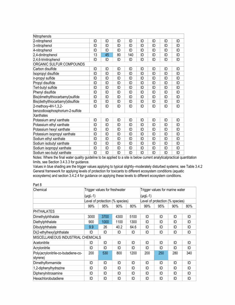
Nitrophenols 2-nitrophenol ID ID ID ID ID ID ID ID 3-nitrophenol ID ID ID ID ID ID ID ID 4-nitrophenol ID ID ID ID ID ID ID ID 2,4-dinitrophenol 13 45 80 140 ID ID ID ID 2,4,6-trinitrophenol ID ID ID ID ID ID ID ID ORGANIC SULFUR COMPOUNDS Carbon disulfide ID ID ID ID ID ID ID ID
Isopropyl disulfide ID ID ID ID ID ID ID ID n-propyl sulfide ID ID ID ID ID ID ID ID Propyl disulfide ID ID ID ID ID ID ID ID Tert-butyl sulfide ID ID ID ID ID ID ID ID Phenyl disulfide ID ID ID ID ID ID ID ID Bis(dimethylthiocarbamyl)sulfide ID ID ID ID ID ID ID ID Bis(diethylthiocarbamyl)disulfide ID ID ID ID ID ID ID ID
2-methoxy-4H-1,3,2-benzodioxaphosphorium-2-sulfide
ID ID ID ID ID ID ID ID
Xanthates Potassium amyl xanthate ID ID ID ID ID ID ID ID
Potassium ethyl xanthate ID ID ID ID ID ID ID ID Potassium hexyl xanthate ID ID ID ID ID ID ID ID Potassium isopropyl xanthate ID ID ID ID ID ID ID ID Sodium ethyl xanthate ID ID ID ID ID ID ID ID Sodium isobutyl xanthate ID ID ID ID ID ID ID ID Sodium isopropyl xanthate ID ID ID ID ID ID ID ID Sodium sec-butyl xanthate ID ID ID ID ID ID ID ID
Notes: Where the final water quality guideline to be applied to a site is below current analyticalpractical quantitation limits, see Section 3.4.3.3 for guidance. Values in blue shading are the trigger values applying to typical slightly–moderately disturbed systems; see Table 3.4.2 General framework for applying levels of protection for toxicants to different ecosystem conditions (aquatic ecosystems) and section 3.4.2.4 for guidance on applying these levels to different ecosystem conditions. Part 8
Chemical Trigger values for freshwater
(µgL-1)
Trigger values for marine water
(µgL-1)
Level of protection (% species) Level of protection (% species)
99% 95% 90% 80% 99% 95% 90% 80%
PHTHALATES
Dimethylphthalate 3000 3700 4300 5100 ID ID ID ID
Diethylphthalate 900 1000 1100 1300 ID ID ID ID
Dibutylphthalate 9.9 26 40.2 64.6 ID ID ID ID
Di(2-ethylhexyl)phthalate ID ID ID ID ID ID ID ID
MISCELLANEOUS INDUSTRIAL CHEMICALS
Acetonitrile ID ID ID ID ID ID ID ID
Acrylonitrile ID ID ID ID ID ID ID ID
Poly(acrylonitrile-co-butadiene-co-styrene)
200 530 800 1200 200 250 280 340
Dimethylformamide ID ID ID ID ID ID ID ID
1,2-diphenylhydrazine ID ID ID ID ID ID ID ID
Diphenylnitrosamine ID ID ID ID ID ID ID ID
Hexachlorobutadiene ID ID ID ID ID ID ID ID

Hexachlorocyclopentadiene ID ID ID ID ID ID ID ID
Isophorone ID ID ID ID ID ID ID ID
ORGANOCHLORINE PESTICIDES
Aldrin ID ID ID ID ID ID ID ID
Chlordane 0.03 0.08 0.14 0.27 ID ID ID ID
DDE ID ID ID ID ID ID ID ID
DDT 0.006 0.01 0.02 0.04 ID ID ID ID
Dicofol ID ID ID ID ID ID ID ID
Dieldrin ID ID ID ID ID ID ID ID
Endosulfan 0.03 0.2 0.6 1.8 0.005 0.01 0.02 0.05
Endosulfan alpha ID ID ID ID ID ID ID ID
Endosulfan beta ID ID ID ID ID ID ID ID
Endrin 0.01 0.02 0.04 0.06 0.004 0.008 0.01 0.02
Heptachlor 0.01 0.09 0.25 0.7 ID ID ID ID
Lindane 0.07 0.2 0.4 1.0 ID ID ID ID
Methoxychlor ID ID ID ID ID ID ID ID
Mirex ID ID ID ID ID ID ID ID
Toxaphene 0.1 0.2 0.3 0.5 ID ID ID ID
Notes: Where the final water quality guideline to be applied to a site is below current analyticalpractical quantitation limits, see Section 3.4.3.3 for guidance. Values in blue shading are the trigger values applying to typical slightly–moderately disturbed systems; see Table 3.4.2 General framework for applying levels of protection for toxicants to different ecosystem conditions (aquatic ecosystems) and section 3.4.2.4 for guidance on applying these levels to different ecosystem conditions. Most trigger values listed here for non-metallic inorganics and organic chemicals are Moderate reliability figures, derived from acute LC50 data (see 3.4.2.3 for reference to Volume 2). The exceptions are High reliability for freshwater ammonia, 3,4-DCA, endosulfan, chlorpyrifos, esfenvalerate, tebuthiuron, three surfactants and marine for 1,1,2-TCE and chlorpyrifos. Part 9 Chemical Trigger values for freshwater
(µgL-1)
Trigger values for marine water
(µgL-1) Level of protection (% species) Level of protection (% species) 99% 95% 90% 80% 99% 95% 90% 80% ORGANOPHOSPHORUS PESTICIDES Azinphos methyl 0.01 0.02 0.05 0.11 ID ID ID ID
Chlorpyrifos 0.00004 0.01 0.11 1.2 0.0005 0.009 Demeton ID ID ID ID ID ID ID ID Demeton-S-methyl ID ID ID ID ID ID ID ID Diazinon 0.00003 0.01 0.2 2 ID ID ID ID
Dimethoate 0.1 0.15 0.2 0.3 ID ID ID ID Fenitrothion 0.1 0.2 0.3 0.4 ID ID ID ID Malathion 0.002 0.05 0.2 1.1 ID ID ID ID
Parathion 0.0007 0.004 0.01 0.04 ID ID ID ID Profenofos ID ID ID ID ID ID ID ID Temephos ID ID ID ID 0.0004 0.05 0.4 CARBAMATE & OTHER PESTICIDES
Carbofuran 0.06 1.2 4 15 ID ID ID ID Methomyl 0.5 3.5 9.5 23 ID ID ID ID S-methoprene ID ID ID ID ID ID ID ID PYRETHROIDS

Deltamethrin ID ID ID ID ID ID ID ID Esfenvalerate ID 0.001 ID ID ID ID ID ID HERBICIDES & FUNGICIDES Bypyridilium herbicides
Diquat 0.01 1.4 10 80 ID ID ID ID Paraquat ID ID ID ID ID ID ID ID
Phenoxyacetic acid herbicides MCPA ID ID ID ID ID ID ID ID 2,4-D 140 280 450 830 ID ID ID ID 2,4,5-T 3 36 100 290 ID ID ID ID
Sulfonylurea herbicides Bensulfuron ID ID ID ID ID ID ID ID Metsulfuron ID ID ID ID ID ID ID ID Notes: Where the final water quality guideline to be applied to a site is below current analyticalpractical quantitation limits, see Section 3.4.3.3 for guidance. Values in blue shading are the trigger values applying to typical slightly–moderately disturbed systems; see Table 3.4.2 General framework for applying levels of protection for toxicants to different ecosystem conditions (aquatic ecosystems) and section 3.4.2.4 for guidance on applying these levels to different ecosystem conditions. Most trigger values listed here for non-metallic inorganics and organic chemicals are Moderate reliability figures, derived from acute LC50 data (see 3.4.2.3 for reference to Volume 2). The exceptions are High reliability for freshwater ammonia, 3,4-DCA, endosulfan, chlorpyrifos, esfenvalerate, tebuthiuron, three surfactants and marine for 1,1,2-TCE and chlorpyrifos. Part 10
Chemical Trigger values for freshwater
(µgL-1)
Trigger values for marine water
(µgL-1)
Level of protection (% species) Level of protection (% species)
99% 95% 90% 80% 99% 95% 90% 80%
Thiocarbamate herbicides
Molinate 0.1 3.4 14 57 ID ID ID ID
Thiobencarb 1 2.8 4.6 8 ID ID ID ID
Thiram 0.01 0.2 0.8 3 ID ID ID ID
Triazine herbicides
Amitrole ID ID ID ID ID ID ID ID
Atrazine 0.7 13 45 150 ID ID ID ID
Hexazinone ID ID ID ID ID ID ID ID
Simazine 0.2 3.2 11 35 ID ID ID ID
Urea herbicides
Diuron ID ID ID ID ID ID ID ID
Tebuthiuron 0.02 2.2 20 160 ID ID ID ID
Miscellaneous herbicides
Acrolein ID ID ID ID ID ID ID ID
Bromacil ID ID ID ID ID ID ID ID

Glyphosate 370 1200 2000 3600 ID ID ID ID
Imazethapyr ID ID ID ID ID ID ID ID
Ioxynil ID ID ID ID ID ID ID ID
Metolachlor ID ID ID ID ID ID ID ID
Sethoxydim ID ID ID ID ID ID ID ID
2.6 4.4 6 9 ID ID ID ID
GENERIC GROUPS OF CHEMICALS
Surfactants
Linear alkylbenzene sulfonates (LAS) 65 280 520 1000 ID ID ID ID
Alcohol ethoxyolated sulfate (AES) 340 650 850 1100 ID ID ID ID
Alcohol ethoxylated surfactants (AE) 50 140 220 360 ID ID ID ID
Oils & Petroleum Hydrocarbons ID ID ID ID ID ID ID ID
Oil Spill Dispersants
BP 1100X ID ID ID ID ID ID ID ID
Corexit 7664 ID ID ID ID ID ID ID ID
Corexit 8667 ID ID ID ID ID ID ID ID
Corexit 9527 ID ID ID ID 230 1100 2200 4400
Corexit 9550 ID ID ID ID ID ID ID ID
Notes: Where the final water quality guideline to be applied to a site is below current analyticalpractical quantitation limits, see Section 3.4.3.3 for guidance. Values in blue shading are the trigger values applying to typical slightly–moderately disturbed systems; see Table 3.4.2 General framework for applying levels of protection for toxicants to different ecosystem conditions (aquatic ecosystems) and section 3.4.2.4 for guidance on applying these levels to different ecosystem conditions. Most trigger values listed here for non-metallic inorganics and organic chemicals are Moderate reliability figures, derived from acute LC50 data (see 3.4.2.3 for reference to Volume 2). The exceptions are High reliability for freshwater ammonia, 3,4-DCA, endosulfan, chlorpyrifos, esfenvalerate, tebuthiuron, three surfactants and marine for 1,1,2-TCE and chlorpyrifos.
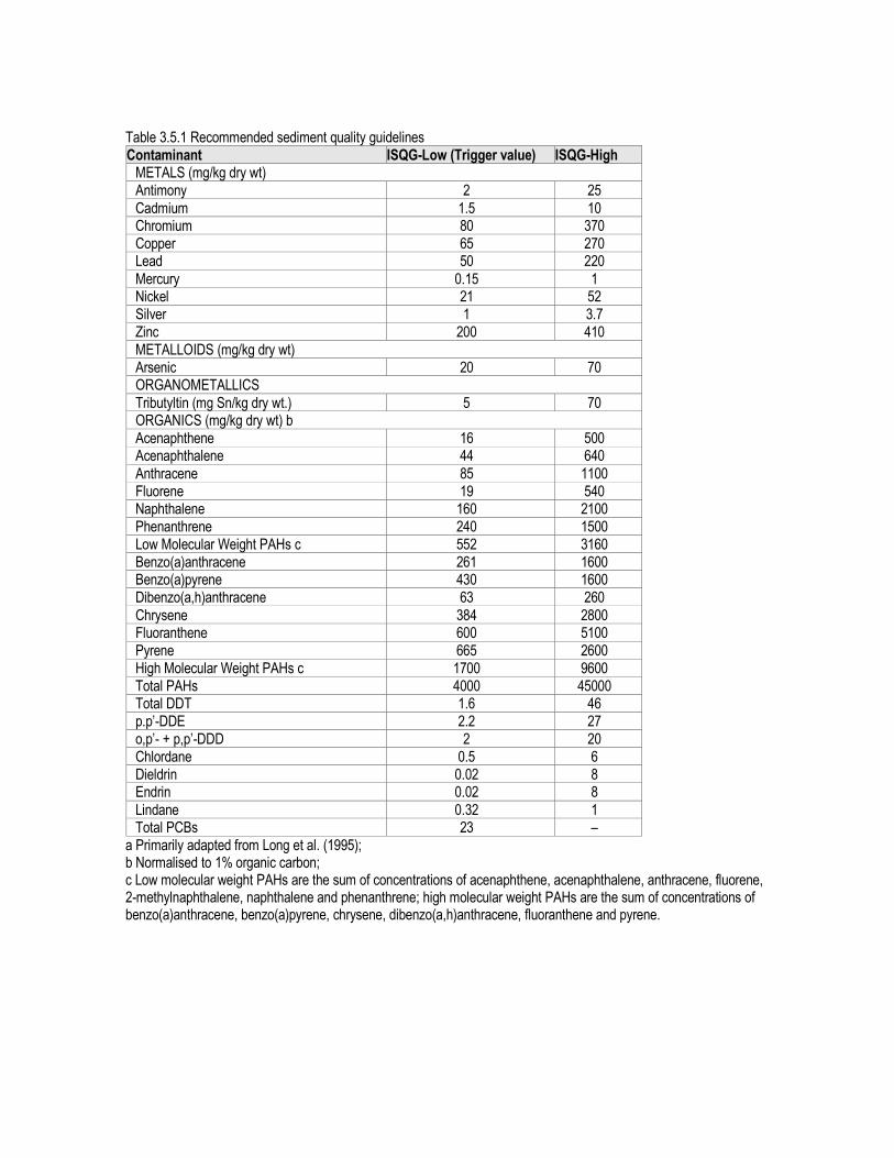
Table 3.5.1 Recommended sediment quality guidelines Contaminant ISQG-Low (Trigger value) ISQG-High METALS (mg/kg dry wt) Antimony 2 25
Cadmium 1.5 10 Chromium 80 370 Copper 65 270 Lead 50 220
Mercury 0.15 1 Nickel 21 52 Silver 1 3.7 Zinc 200 410 METALLOIDS (mg/kg dry wt) Arsenic 20 70 ORGANOMETALLICS
Tributyltin (mg Sn/kg dry wt.) 5 70 ORGANICS (mg/kg dry wt) b Acenaphthene 16 500 Acenaphthalene 44 640
Anthracene 85 1100 Fluorene 19 540 Naphthalene 160 2100 Phenanthrene 240 1500 Low Molecular Weight PAHs c 552 3160 Benzo(a)anthracene 261 1600 Benzo(a)pyrene 430 1600 Dibenzo(a,h)anthracene 63 260
Chrysene 384 2800 Fluoranthene 600 5100 Pyrene 665 2600 High Molecular Weight PAHs c 1700 9600 Total PAHs 4000 45000 Total DDT 1.6 46 p.p’-DDE 2.2 27 o,p’- + p,p’-DDD 2 20 Chlordane 0.5 6 Dieldrin 0.02 8 Endrin 0.02 8
Lindane 0.32 1 Total PCBs 23 –
a Primarily adapted from Long et al. (1995); b Normalised to 1% organic carbon; c Low molecular weight PAHs are the sum of concentrations of acenaphthene, acenaphthalene, anthracene, fluorene, 2-methylnaphthalene, naphthalene and phenanthrene; high molecular weight PAHs are the sum of concentrations of benzo(a)anthracene, benzo(a)pyrene, chrysene, dibenzo(a,h)anthracene, fluoranthene and pyrene.

Primary industries: irrigation and general water use Tables 4.2.2 – 4.2.15 Values for coliforms, salinity and other major ions, nutrients, general toxicants, natural physical and chemical indicators, radiological contaminants Table 4.2.2 Trigger values for thermotolerant coliforms in irrigation waters used for food and non-food cropsa Intended use Level of thermotolerant coliforms b Raw human food crops in direct contact with irrigation water (e.g. via sprays, irrigation of salad vegetables)
<10 cfuc / 100 mL
Raw human food crops not in direct contact with irrigation water (edible product separated from contact with water, e.g. by peel, use of trickle irrigation); or crops sold to consumers cooked or processed
<1000 cfu / 100 mL
Pasture and fodder for dairy animals (without withholding period) <100 cfu / 100 mL Pasture and fodder for dairy animals (with withholding period of 5 days) <1000 cfu / 100 mL Pasture and fodder (for grazing animals except pigs and dairy animals, i.e. cattle, sheep and goats)
<1000 cfu / 100 mL
Silviculture, turf, cotton, etc. (restricted public access) <10 000 cfu / 100 mL a Adapted from ARMCANZ, ANZECC & NHMRC (1999) b Median values (refer to text) c cfu = colony forming units Table 4.2.3 Soil type and average root zone leaching fraction Table 4.2.4 Soil and water salinity criteria based on plant salt tolerance groupings
Plant salt tolerance groupings Water or soil salinity rating Average root zone salinity, ECse (dS/m)* Sensitive crops Moderately sensitive crops Moderately tolerant crops Tolerant crops Very tolerant crops Generally too saline
Very low Low
Medium High
Very high Extreme
<0.95 0.95-1.9 1.9-4.5 4.5-7.7 7.7-12.2 >12.2
Adapted from DNR (1997b) * 1 dS/m = 1000 µS/cm Table 4.2.5 Tolerance of plants to salinity in irrigation water Table 4.2.6 Chloride concentrations (mg/L) causing foliar injury in crops of varying sensitivity Table 4.2.7 Risks of increasing cadmium concentrations in crops due to chloride in irrigation waters Table 4.2.8 Sodium concentration (mg/L) causing foliar injury in crops of varying sensitivity Table 4.2.9 Effect of sodium expressed as sodium adsorption ratio (SAR) on crop yield and quality under non-saline conditions Table 4.2.10 Agricultural irrigation water triggers for heavy metals and metalloids Element Suggested soil CCLb LTV in irrigation water (long-
term use — up to 100 yrs) STV in irrigation water (short-term use — up to 20 yrs)
(kg/ha) (mg/L) (mg/L) Aluminium ND 5 20 Arsenic 20 0.1 2.0 Beryllium ND 0.1 0.5 Boron ND 0.5 Refer to table 9.2.18 (Volume 3) Cadmium 2 0.01 0.05 Chromium ND 0.1 1
Cobalt ND 0.05 0.1 Copper 140 0.2 5

Fluoride ND 1 2 Iron ND 0.2 10 Lead 260 2 5 Lithium ND 2.5 (0.075 Citrus crops) 2.5 (0.075 Citrus crops) Manganese ND 0.2 10 Mercury 2 0.002 0.002 Molybdenum ND 0.01 0.05 Nickel 85 0.2 2
Selenium 10 0.02 0.05 Uranium ND 0.01 0.1 Vanadium ND 0.1 0.5 Zinc 300 2 5 Table 4.2.11 Agricultural irrigation water long-term trigger value (LTV) and short-term trigger value (STV) guidelines for N & P Element LTV in irrigation water (long-term — up
to 100 yrs) (mg/L) STV in irrigation water (short-term — up to 20 yrs) (mg/L)
Nitrogen 5 25–125 a Phosphorus 0.05
(To minimise bioclogging of irrigation equipment only)
0.8–12 a
Requires site-specific assessment Table 4.2.12 Interim trigger value concentrations for a range of herbicides registered in Australia for use in or near waters (Part 1 and Part 2) Herbicide Residue limits in
irrigation water (mg/L)b
Hazard to crops from residue in waterc
Crop injury threshold in irrigation water (mg/L)
Acrolein 0.1 + Flood or furrow: beans 60, corn 60, cotton 80, soybeans 20, sugar-beets 60. Sprinkler: corn 60, soybeans 15, sugar-beets 15
AF 100 + Beets (rutabaga) 3.5, corn 3.5 Amitrol 0.002 ++ Lucerne 1600, beans 1200, carrots
1600, corn 3000, cotton 1600, grains sorghum 800
Aromatic solvents (Xylene)
+ Oats 2400, potatoes 1300, wheat 1200
Asulam ++ Atrazine ++ Bromazil +++ Chlorthiamid ++
Copper sulfate + Apparently above concentrations used for weed control
2,4-D ++ Field beans 3.5–10, grapes 0.7–1.5, sugar-beets 1.0–10
Dicamba ++ Cotton 0.18 Dichlobenil ++ Lucerne 10, corn 10, soybeans 1.0,
sugar-beets 1.0–10, corn 125, beans 5 Diquat + Diuron 0.002 +++ 2,2-DPA (Dalapon) 0.004 ++ Beets 7.0, corn 0.35

Fosamine +++ Fluometuron ++ Sugar-beets, alfalfa, tomatoes, squash 2.2 Glyphosate + Hexazinone +++ Karbutilate +++ Molinate ++ Paraquat + Corn 10, field beans 0.1, sugar-beets 1.0 Picloram +++
Propanil ++ Alfalfa 0.15, brome grass (eradicated) 0.15 Simazine ++ 2,4,5-T ++ Potatoes, alfalfa, garden peas, corn, sugar-
beets, wheat, peaches, grapes, apples, tomatoes 0.5
TCA (Trichloroacetic acid)
+++
Terbutryne ++ Triclopyr ++
a From ANZECC (1992). These should be regarded as interim trigger values only. b Guidelines have not been set for herbicides where specific residue limits are not provided, except for a general limit of 0.01 mg/L for all herbicides in NSW. c Hazard from residue at maximum concentration likely to be found in irrigation water: + = low, ++ = moderate, +++ = high Table 4.2.13 Trigger values for radioactive contaminants for irrigation water Table 4.2.14 Corrosion potential of waters on metal surfaces as indicated by pH, hardness, Langelier index, Ryznar index and the log of chloride:carbonate ratio Table 4.2.15 Fouling potential of waters as indicated by pH, hardness, Langelier index, Ryznar index and the log of chloride:carbonate ratio
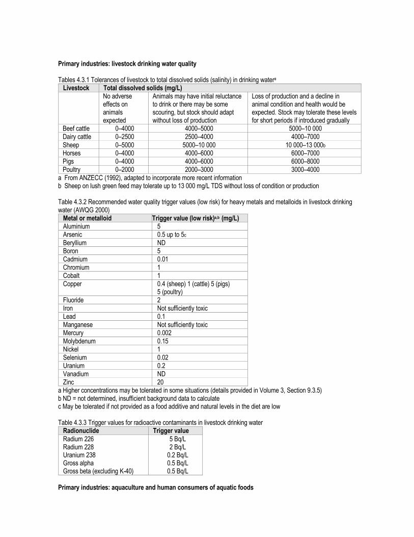
Primary industries: livestock drinking water quality Tables 4.3.1 Tolerances of livestock to total dissolved solids (salinity) in drinking watera Livestock Total dissolved solids (mg/L)
No adverse effects on animals expected
Animals may have initial reluctance to drink or there may be some scouring, but stock should adapt without loss of production
Loss of production and a decline in animal condition and health would be expected. Stock may tolerate these levels for short periods if introduced gradually
Beef cattle 0–4000 4000–5000 5000–10 000 Dairy cattle 0–2500 2500–4000 4000–7000
Sheep 0–5000 5000–10 000 10 000–13 000b Horses 0–4000 4000–6000 6000–7000 Pigs 0–4000 4000–6000 6000–8000 Poultry 0–2000 2000–3000 3000–4000
a From ANZECC (1992), adapted to incorporate more recent information b Sheep on lush green feed may tolerate up to 13 000 mg/L TDS without loss of condition or production Table 4.3.2 Recommended water quality trigger values (low risk) for heavy metals and metalloids in livestock drinking water (AWQG 2000) Metal or metalloid Trigger value (low risk)a,b (mg/L) Aluminium 5 Arsenic 0.5 up to 5c
Beryllium ND Boron 5 Cadmium 0.01 Chromium 1 Cobalt 1 Copper 0.4 (sheep) 1 (cattle) 5 (pigs)
5 (poultry) Fluoride 2 Iron Not sufficiently toxic Lead 0.1 Manganese Not sufficiently toxic Mercury 0.002
Molybdenum 0.15 Nickel 1 Selenium 0.02 Uranium 0.2 Vanadium ND Zinc 20
a Higher concentrations may be tolerated in some situations (details provided in Volume 3, Section 9.3.5) b ND = not determined, insufficient background data to calculate c May be tolerated if not provided as a food additive and natural levels in the diet are low Table 4.3.3 Trigger values for radioactive contaminants in livestock drinking water Radionuclide Trigger value
Radium 226 Radium 228 Uranium 238 Gross alpha Gross beta (excluding K-40)
5 Bq/L 2 Bq/L 0.2 Bq/L 0.5 Bq/L 0.5 Bq/L
Primary industries: aquaculture and human consumers of aquatic foods

Table 4.4.1 Representative aquaculture species, occurrence and culture status Tables 4.4.2 Physico-chemical stressor guidelines for the protection of aquaculture species Measured parameter Recommended guideline (mg/L) Freshwater production Saltwater production Alkalinity ³205 >203 Biochemical oxygen demand (BOD5)
<151 ND
Chemical oxygen demand (COD) <401 ND
Carbon dioxide <10 <15 Colour and appearance of water 30–402 (Pt-Co units) 30–402 (Pt-Co units) Dissolved oxygen >53 >53 Gas supersaturation <100%6 <100%6
Hardness (CaCO3) 20–1005 NC6 pH 5.0–9.0 6.0-9.0 Salinity (total dissolved solids) <30006 33 000–37 0006 (3000–35 000
Brackish)6 Suspended solids <40 <10
(<75 Brackish) Temperature <2.0°C change over 1 hour4 <2.0°C change over 1 hour4
1 Schlotfeldt & Alderman (1995) 2 O’Connor pers. comm. 3 Meade (1989) 4 ANZECC (1992) 5 DWAF (1996) 6 Lawson (1995) 7 Others are based on professional judgements of the project team. Table 4.4.3 Toxicant guidelines for the protection of aquaculture species Measured parameter Guideline (µg/L)
Freshwater production Saltwater production INORGANIC TOXICANTS (HEAVY METALS AND OTHERS) Aluminium <30 (pH >6.5)1
<10 (pH <6.5) <101
Ammonia (un-ionised) <20 (pH >8.0) coldwater2 <30 warmwater2
<100
Arsenic <501,2 <301,2 Cadmium (varies with hardness) <0.2–1.82 <0.5–51 Chlorine <31 <31 Chromium <202 <20 Copper (varies with hardness) <52 <53 Cyanide <51 <51
Fluorides <204 ND Hydrogen sulfide <12 <2 Iron <101 <101 Lead (varies with hardness) <1–74 <1–74
Magnesium <15 0001 ND Manganese <101,5 <101,5 Mercury <1 <1 Nickel <1001 <1001 Nitrate (NO3
-) <50 0006 <100 0003,7 Nitrite (NO2) <1001,7 <1001,7
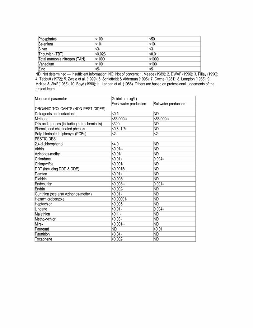
Phosphates <1002 <50 Selenium <101 <101 Silver <31 <31 Tributyltin (TBT) <0.0261 <0.011 Total ammonia nitrogen (TAN) <10001 <10001 Vanadium <1001 <1001 Zinc <51 <51
ND: Not determined — insufficient information; NC: Not of concern; 1. Meade (1989); 2. DWAF (1996); 3. Pillay (1990); 4. Tebbutt (1972); 5. Zweig et al. (1999); 6. Schlotfeldt & Alderman (1995); 7. Coche (1981); 8. Langdon (1988); 9. McKee & Wolf (1963); 10. Boyd (1990);11. Lannan et al. (1986). Others are based on professional judgements of the project team. Measured parameter Guideline (µg/L)
Freshwater production Saltwater production ORGANIC TOXICANTS (NON-PESTICIDES) Detergents and surfactants <0.18 ND
Methane <65 0009,10 <65 0009,10 Oils and greases (including petrochemicals) <3006 ND Phenols and chlorinated phenols <0.6–1.76 ND Polychlorinated biphenyls (PCBs) <21 <21
PESTICIDES 2,4-dichlorophenol <4.02 ND Aldrin <0.012,3,8 ND Azinphos-methyl <0.012 ND Chlordane <0.0111 0.00411 Chlorpyrifos <0.0012 ND DDT (including DDD & DDE) <0.00152 ND Demton <0.0111 ND Dieldrin <0.0052 ND Endosulfan <0.0032,11 0.00111 Endrin <0.0022 ND Gunthion (see also Azinphos-methyl) <0.0111 ND Hexachlorobenzole <0.000016 ND Heptachlor <0.0052 ND Lindane <0.0111 0.00411 Malathion <0.15,11 ND Methoxychlor <0.0311 ND Mirex <0.0012,11 ND Paraquat ND <0.01
Parathion <0.0411 ND Toxaphene <0.0022 ND

Table 5.1.2 The general recommended levels of water quality parameters for Tropical aquaculture
Recommended range Recommended range Water parameter
Freshwater Marine
Water parameter
General aquatic
Dissolved oxygen >4mg/L >4mg/L Arsenic <0.05mg/L
Temperature oC 21-32 24-33 Cadmium <0.003mg/L
pH 6.8-9.5 7-9.0 Calcium/Magnesium 10-160mg/L
Ammonia (TAN, total ammonia-nitrogen)
<1.0mg/L <1.0mg/L Chromium <0.1mg/L
Ammonia (NH3, Unionised form)
<0.1mg/L <0.1mg/L Copper <0.006mg/L in soft water
Nitrate (NO3) 1-100mg/L 1-100mg/L Cyanide <0.006mg/L
Nitrite (NO2) <0.1mg/L <1.0mg/L Iron <0.5mg/L
Salinity 0-5ppt 15-35ppt Lead <0.03mg/L
Hardness 20-450mg/L Manganese <0.01mg/L
Alkalinity 20-400mg/L >100mg/L Mercury <0.00005mg/L
Turbidity <80NTU Nickel <0.01mg/L in soft water <0.04mg/L in hard water
Chlorine <0.003mg/L Tin <0.001mg/L
Hydrogen sulphide <0.002mg/L Zinc 0.03-0.06mg/L in soft water
Source: Queensland Water Quality Guidelines (EPA 2006)

Recreational water quality and aesthetics Table 5.2.1 Water quality characteristics relevant to recreational use Table 5.2.2 Summary of water quality guidelines for recreational waters
Parameter Guideline Microbiological Primary contact* The median bacterial content in fresh and marine waters taken over the bathing
season should not exceed 150 faecal coliform organisms/100 mL or 35 enterococci organisms/100 mL. Pathogenic free-living protozoans should be absent from bodies of fresh water.**
Secondary contact* The median value in fresh and marine waters should not exceed 1000 faecal coliform organisms/100 mL or 230 enterococci organisms/100 mL.**
Nuisance organisms Macrophytes, phytoplankton scums, filamentous algal mats, sewage fungus, leeches, etc., should not be present in excessive amounts.* Direct contact activities should be discouraged if algal levels of 15 000–20 000 cells/mL are present, depending on the algal species. Large numbers of midges and aquatic worms should also be avoided.
Physical and chemical
Visual clarity & colour To protect the aesthetic quality of a waterbody: q the natural visual clarity should not be reduced by more than 20% q the natural hue of the water should not be changed by more than 10 points on the Munsell Scale; q the natural reflectance of the water should not be changed by more than 50%. To protect the visual clarity of waters used for swimming, the horizontal sighting of a 200 mm diameter black disc should exceed 1.6 m.
pH The pH of the water should be within the range 5.0–9.0, assuming that the buffering capacity of the water is low near the extremes of the pH limits.
Temperature For prolonged exposure, temperatures should be in the range 15–35°C. Toxic chemicals Waters containing chemicals that are either toxic or irritating to the skin or mucous
membranes are unsuitable for recreation. Toxic substances should not exceed values in tables 5.2.3 and 5.2.4.
Surface films Oil and petrochemicals should not be noticeable as a visible film on the water nor should they be detectable by odour.
* Refer to Section 3.3 of these revised Guidelines relating to nutrient concentrations necessary to limit excessive aquatic plant growth. ** Sampling frequency and maximum values are given in Section 5.2.3.1. Tables 5.2.3 Summary of water quality guidelines for recreational purposes: general chemicals (Part 1 and 2) Parameter Guideline values (µg/L, unless otherwise stated) Inorganic: Arsenic 50 Asbestos NR Barium 1000 Boron 1000 Cadmium 5 Chromium 50 Cyanide 100 Lead 50 Mercury 1
Nickel 100 Nitrate-N 10 000 Nitrite-N 1000

Selenium 10 Silver 50 Organic: Benzene 10 Benzo(a)pyrene 0.01 Carbon tetrachloride 3 1,1-Dichloroethene 0.3 1,2-Dichloroethane 10
Pentachlorophenol 10 Polychlorinated biphenyls 0.1 Tetrachloroethene 10 2,3,4,6-Tetrachlorophenol 1 Trichloroethene 30 2,4,5-Trichlorophenol 1 2,4,6-Trichlorophenol 10
Radiological: Gross alpha activity 0.1 Bq/L Gross beta activity (excluding activity of 40K) 0.1 Bq/L Other chemicals:
Aluminium 200 Ammonia (as N) 10 Chloride 400 000 Copper 1000 Oxygen >6.5 (>80% saturation) Hardness (as CaCO3) 500 000 Iron 300
Manganese 100 Organics (CCE & CAE) 200 pH 6.5–8.5 Phenolics 2 Sodium 300 000 Sulfate 400 000 Sulfide 50 Surfactant (MBAS) 200 Total dissolved solids 1 000 000 Zinc 5000
Tables 5.2.4 Summary of water quality guidelines for recreational purposes: pesticides (Part 1 and 2)
Compound Maximum concentration (µg/L)
Compound Maximum concentration (µg/L)
Acephate 20 Demeton 30 Alachlor 3 Diazinon 10 Aldrin 1 Dicamba 300 Amitrol 1 Dichlobenil 20 Asulam 100 3,6-Dichloropicolinic acid 1000 Azinphos-methyl 10 Dichlorvos 20 Barban 300 Diclofop-methyl 3 Benomyl 200 Dicofol 100 Bentazone 400 Dieldrin 1
Bioresmethrin 60 Difenzoquat 200 Bromazil 600 Dimethoate 100 Bromophos-ethyl 20 Diquat 10
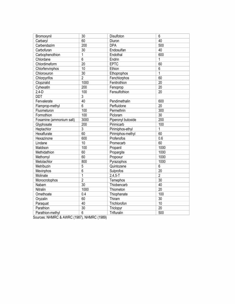
Bromoxynil 30 Disulfoton 6 Carbaryl 60 Diuron 40 Carbendazim 200 DPA 500 Carbofuran 30 Endosulfan 40 Carbophenothion 1 Endothal 600 Chlordane 6 Endrin 1 Chlordimeform 20 EPTC 60 Chlorfenvinphos 10 Ethion 6
Chloroxuron 30 Ethoprophos 1 Chlorpyrifos 2 Fenchlorphos 60 Clopzralid 1000 Fenitrothion 20 Cyhexatin 200 Fenoprop 20 2,4-D 100 Fensulfothion 20 DDT 3 Fenvalerate 40 Pendimethalin 600
Flamprop-methyl 6 Perfluidone 20 Fluometuron 100 Permethrin 300 Formothion 100 Picloram 30 Fosamine (ammonium salt) 3000 Piperonyl butoxide 200
Glyphosate 200 Pirimicarb 100 Heptachlor 3 Pirimiphos-ethyl 1 Hexaflurate 60 Pirimiphos-methyl 60 Hexazinone 600 Profenofos 0.6 Lindane 10 Promecarb 60 Maldison 100 Propanil 1000 Methidathion 60 Propargite 1000
Methomyl 60 Propoxur 1000 Metolachlor 800 Pyrazophos 1000 Metribuzin 5 Quintozene 6 Mevinphos 6 Sulprofos 20 Molinate 1 2,4,5-T 2 Monocrotophos 2 Temephos 30 Nabam 30 Thiobencarb 40 Nitralin 1000 Thiometon 20 Omethoate 0.4 Thiophanate 100 Oryzalin 60 Thiram 30 Paraquat 40 Trichlorofon 10 Parathion 30 Triclopyr 20
Parathion-methyl 6 Trifluralin 500 Sources: NHMRC & AWRC (1987), NHMRC (1989)

Table 5.2.1 Guidelines for blue-green algae for primary contact recreation (QWQG EPA 2006)
Hazard status
Guidance level or situation
Health risks Recommended action
High Cyanobacterial scum formation in contact recreation areas or >100,000 cells total cyanobacteria mL-1 or >50 µg L-1 chlorophyll-a with dominance of cyanobacteria.
• Short-term adverse health outcomes such as skin irritations or gastrointestinal illness following contact or accidental ingestion
• Severe acute poisoning is possible in worst ingestion cases
• Immediate action to prevent contact with scums
• Signs to indicate high alert level – warning of danger for swimming and other water contact activities
Moderate 20,000–100,000 cells total cyanobacteria mL-1 or 10–50µg L-1 chlorophyll-a with dominance of cyanobacteria.
• Short-term adverse health outcomes e.g. skin irritations, gastrointestinal illness, probably at low frequency
• Signs to indicate moderate alert level – increased health risk for swimming and other water-contact activities
Low <20,000 cells total cyanobacteria mL-1 or <10µg L-1 chlorophyll-a with dominance of cyanobacteria.
• Short-term adverse health outcomes unlikely
• Signs to indicate cyanobacteria either absent or present at low levels

Table 9.3 Sources of Chemicals in Recreational Water (NHMRC Recreational Water Quality Guidelines)
Drinking water guideline valuesa (mg/L)
Potential sources of contamination Chemical
Health Aesthetic Naturally
occurring Agricultural
activities Human
settlements Industry
Acephate 0.01 �
Acrylamide 0.0002 �
Aldicarb 0.001 � �
Aldrin/dieldrin 0.0003 � �
Ametryn 0.05 �
Amitrole 0.01 � �
Ammonia 0.5 � � �
Antimony 0.003 � �
Arsenic 0.007 � �
Asbestos b �
Asulam 0.05 �
Atrazine 0.04 � � �
Azinphos-methyl 0.003 � �
Barium 0.7 � �
Benomyl 0.1 �
Bentazone 0.03 � �
Benzene 0.001 � �
Benzo[a]pyrene 0.00001 � �
Beryllium * � �
Bioresmethrin 0.1 � �
Boron 0.03 � � �
Bromacil 0.3 �
Bromate 0.02 �
Bromochloroacetonitrile * �
Bromophos-ethyl 0.01 �
Bromoxynil 0.03 � �
Cadmium 0.002 � �
Carbaryl 0.03 �
Carbendazin 0.1 �
Carbofuran 0.01 0.005 � �
Carbon tetrachloride 0.003 � �
Carbophenothion 0.0005 �
Carboxin 0.3 �
Chloral hydrate 0.02 �

Chlordane 0.001 � �
Chlorfenvinphos 0.005 �
Chloride 250 � � �
Chlorite 0.3 � �
Chloroacetic acid 0.15 �
Chlorobenzene 0.3 �
2-Chlorophenol 0.3 0.0001 � �
Chlorothalonil 0.03 �
Chloroxuron 0.01 �
Chlorpyrifos 0.01 � �
Chlorsulfuron 0.1 �
Chromium 0.05 � �
Clopyralid 1 �
Copper 2 1 � � �
Cyanide 0.08 � �
Cyanogen chloride (as
CN)
0.08 �
D 2,4- 0.03 � �
DDT 0.02 � �
Dialkyltins b �
Diazinon 0.003 � �
Dibromoacetonitrile b �
Dicamba 0.1 �
Dichlobenil 0.01 � �
Dichloroacetic acid 0.1 �
Dichloroacetonitrile b �
1,2-dichlorobenzene 1.5 0.001 �
1,3-dichlorobenzene c 0.02 �
1,4-dichlorobenzene 0.0003 0.02 �
1,1-dichloroethane c �
1,2-dichloroethane 0.003 �
1,1-Dichloroethene 0.03 �
1,2-dichloroethene 0.06 �
Dichloromethane 0.004 � �
2,4-Dichlorophenol 0.2 �
Dichlor vos 0.001 �
Dicofol 0.003 �
Dicofop-methyl 0.005 �

Difenzoquat 0.1 �
Dimethoate 0.05 � �
Diphemamid 0.3 �
Dioxin (2,3,7,8-TCDD)
Diquat 0.005 � �
Disulfoton 0.003 �
Diuron 0.03 �
2,2-DPA 0.5 � �
EDB 0.001 �
Endosulfan 0.03 � �
Endothal 0.1 �
Epichlorohydrin 0.0005 �
EPTC 0.03 �
Ethion 0.003 �
Ethoprophos 0.001 �
Ethylbenzene 0.3 0.003 � �
Ethylenediamine tetraacetic acid (EDTA)
0.25 � �
Etridiazole 0.1 �
Fenamiphos 0.0003 � �
Fenarimol 0.03 � �
Fenchlorphos 0.03 �
Fenitrothion 0.01 � �
Fenoprop 0.01 � �
Fensulfothion 0.01 �
Fenvalerate 0.05 �
Flamprop-methyl 0.003 �
Fluometuron 0.05 �
Fluoride 1.5 � �
Formothion 0.05 �
Fosamine 0.03 �
Glyphosate 1 � �
Heptachlor and
Heptachlor epoxide
0.0003 � �
Hexachlorobutadiene 0.0007 �
Hexaflurate 0.03 �
Hexazinone 0.3 �
Hydrogen sulfide 0.05 �

Iodide 0.1 � �
Iron 0.3 �
Lead 0.01 � � �
Lindane 0.02 � �
Maldison 0.05 � �
Manganese 0.5 0.1 � �
Mercury (total) 0.001 � �
Methidathion 0.03 �
Methiocarb 0.005 �
Methomyl 0.03 �
Methoxychlor 0.3 � �
Metolachlor 0.3 � �
Metribuzin 0.05 �
Metsulfuron-methyl 0.03 �
Mevinphos 0.005 �
Molinate 0.005 � �
Molybdenum 0.05 � � �
Monochlorobenzene 0.01 �
Monocrotophos 0.001 � �
Napropamide 1 �
Nickel 0.02 � � �
Nitralin 0.5 �
Nitrate (as NO3-) 50 � �
Nitrilotriacetic acid 0.2 � �
Nitrite (as NO2-) 3 � �
Norflurazon 0.05 �
Oryzalin 0.3 �
Oxamyl 0.1 �
Paraquat 0.03 �
Parathion 0.01 �
Parathion-methyl 0.1 �
Pebulate 0.03 �
Pendimethalin 0.3 � �
Pentachlorophenol 0.01 � �
Permethrin 0.1 � �
Picloram 0.3 �
Piperonyl butoxide 0.1 � �
Pirimicarb 0.005 �

Pirimiphos-ethyl 0.0005 � �
Pirimiphos-methyl 0.05 �
Profenofos 0.0003 �
Promecarb 0.03 �
Propachlor 0.05 �
Propanil 0.5 �
Propargite 0.05 �
Propazine 0.05 �
Propiconazole 0.1 �
Propyzamide 0.3 � �
Pyrazophos 0.03 �
Quintozene 0.03 �
Selenium 0.01 �
Simazine 0.02 � �
Sodium 180 � �
Styrene 0.03 0.004 � �
Sulfate 500 250 � �
Sulprofos 0.01 � �
Synthetic detergents � �
2,4,5-T 0.1 � �
Temephos 0.3 �
Terbacil 0.03 �
Terbufos 0.0005 �
Terbutryn 0.3
Tetrachloroethene 0.05 � �
Tetrachlor vinphos 0.1 �
Thiobencarb 0.03 �
Thiometon 0.003 �
Thiophanate 0.005 � �
Thiram 0.003 � �
Toluene 0.8 0.025 � �
Triadimefon 0.002 �
Tributyltin oxide 0.001 � �
Trichlorfon 0.005 �
Trichloroacetaldehyde 0.02 �
Trichloroacetic acid 0.1 �
Trichloroacetonitrile b �
Trichlorobenzenes (total) 0.03 0.005 �

1,1,1-trichloroethane b �
Trichloroethylene b �
2,4,6-trichlorophenol 0.02 0.002 �
Triclopyr 0.01 � �
Trifluralin 0.05 � �
Uranium 0.02 � �
Vernolate 0.03 �
Vinyl chloride 0.0003 �
Xylene 0.6 0.02 � �
Zinc 3 � �
� = Primary source of chemical in recreational water � = Secondary sources of chemical in recreational water. Secondary sources must be considered as part of the assessment of priority chemicals a All guideline values listed in Table 9.1 are applicable to drinking water quality and are based on the daily consumption of 2 L.These values should only be used as a guide to deriving chemical values applicable to recreational water bodies. Using a consumption factor of 2 L will result in very conservative health guideline values in recreational water. When applying these values to recreational water exposure, consumption of 100–200 mL per day should be taken into consideration b Insufficient data to set a guideline value based on health considerations c The guideline value is below the limit of determination. Improved analytical procedures are required for this compound. Note: Routine monitoring for pesticides is not required unless potential exists for contamination of the recreational water body
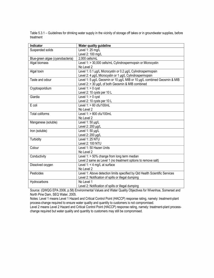
Table 5.3.1 – Guidelines for drinking water supply in the vicinity of storage off takes or in groundwater supplies, before treatment
Indicator Water quality guideline
Suspended solids Level 1: 25 mg/L Level 2: 100 mg/L
Blue-green algae (cyanobacteria) 2,000 cells/mL
Algal biomass Level 1: > 30,000 cells/mL Cylindrospermopsin or Microcystin No Level 2
Algal toxin Level 1: 0.1 µg/L Microcystin or 0.2 µg/L Cylindrospermopsin Level 2: 4 µg/L Microcystin or 1 µg/L Cylindrospermopsin
Taste and odour Level 1: 5 µg/L Geosmin or 10 µg/L MIB or 10 µg/L combined Geosmin & MIB Level 2: > 30 µg/L of both Geosmin & MIB combined
Cryptosporidium Level 1: > 0 cyst Level 2: 10 cysts per 10 L
Giardia Level 1: > 0 cyst Level 2: 10 cysts per 10 L
E coli Level 1: > 60 cfu/100mL No Level 2
Total coliforms Level 1: > 800 cfu/100mL No Level 2
Manganese (soluble) Level 1: 50 µg/L Level 2: 200 µg/L
Iron (soluble) Level 1: 50 µg/L Level 2: 200 µg/L
Turbidity Level 1: 25 NTU Level 2: 100 NTU
Colour Level 1: 50 Hazen Units No Level 2
Conductivity Level 1: > 50% change from long term median Level 2 same as Level 1 (no treatment options to remove salt)
Dissolved oxygen Level 1: < 4 mg/L at surface No Level 2
Pesticides Level 1: Above detection limits specified by Qld Health Scientific Services Level 2: Notification of spills or illegal dumping
Hydrocarbons No Level 1 Level 2: Notification of spills or illegal dumping
Source: (QWQG EPA 2006, p.58) Environmental Values and Water Quality Objectives for Wivenhoe, Somerset and North Pine Dam, SEQ Water, 2005. Notes: Level 1 means Level 1 Hazard and Critical Control Point (HACCP) response rating, namely: treatment-plant process-change required to ensure water quality and quantity to customers is not compromised. Level 2 means Level 2 Hazard and Critical Control Point (HACCP) response rating, namely: treatment-plant process-change required but water quality and quantity to customers may still be compromised.

Australian Drinking Water Quality Guidelines NHMRC 2004 10.8 Summary of guideline values Table 10.9 Guidelines for microbial quality - monitoring of E. coli (or thermotolerant coliforms) Guideline No sample of drinking water should contain any E. coli (or thermotolerant coliforms) (minimum sample 100 mL). Action If E. coli (or thermotolerant coliforms) are detected, then irrespective of the number of organisms, both the following steps should be taken immediately: 1) Another sample (a repeat sample) should be taken from the same site and from the immediate upstream treated sources of supply and tested for the presence of E. coli (or thermotolerant coliforms).
– If the additional samples are negative for E. coli (or thermotolerant coliforms), then routine sampling can resume, but only after step 2 (below) has been completed. – If any additional sample is positive for E. coli (or thermotolerant coliforms), then increased disinfection and a full sanitary survey should be implemented immediately. The sanitary survey should include a review of the integrity of the system.
AND 2) Disinfection should be increased and/or an investigation undertaken to determine possible sources of contamination. These might include a breakdown in disinfection, a mains break, interruption to the supply, surges in supply, or deliberate or accidental contamination of the system. The investigation may include a visual inspection of the system and associated service reservoirs by trained personnel. When found, the source of contamination should be eliminated. Table 10.10 Guideline values for physical and chemical characteristics
Characteristic Guideline value * Comments
Health Aesthetic a Acrylamide 0.0002 Minor impurity of polyacrylamide, used sometimes as a
flocculant aid
Ammonia (as NH3) c 0.5 Presence may indicate sewage contamination and/or microbial activity. High levels may corrode copper pipes and fi ttings.
Antimony 0.003 Exposure may rise with increasing use of antimony-tin solder.
Arsenic 0.007 From natural sources and mining/industrial/agricultural wastes.
Asbestos c From dissolution of minerals/industrial waste, deterioration of asbestos-cement pipes in distribution systems. No evidence of cancer when ingested (unlike inhaled asbestos).
Barium 0.7 Primarily from natural sources.
Benzene 0.001 Could occur in drinking water from atmospheric deposition (motor vehicle emissions) and chemical plant effluent. Human carcinogen.
Boron 4 From natural leaching of minerals and contamination. < 1 mg/L in uncontaminated sources; higher levels may be associated with seawater intrusion.
Cadmium 0.002 Indicates industrial or agricultural contamination; from impurities in galvanised (zinc) fi ttings, solders and brasses.
Chloride e 250 From natural mineral salts, effl uent contamination. High concentrations more common in groundwater and certain catchments.
Chlorine 5 0.6 Widely used to disinfect water, and this can produce (free) chlorinated organic byproducts. Odour threshold generally 0.6 mg/L, but 0.2 mg/L for a few people. In some supplies it may be necessary to exceed the aesthetic guideline in order to maintain an effective disinfectant residual throughout the system.
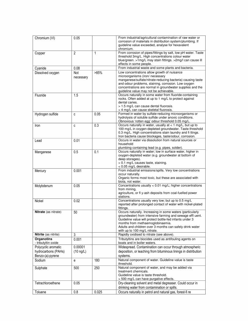
Chromium (VI) 0.05 From industrial/agricultural contamination of raw water or corrosion of materials in distribution system/plumbing. If guideline value exceeded, analyse for hexavalent chromium.
Copper 2 1 From corrosion of pipes/fittings by salt, low pH water. Taste threshold 3mg/L. High concentrations colour water blue/green. >1mg/L may stain fittings. >2mg/l can cause ill effects in some people.
Cyanide 0.08 From industrial waste and some plants and bacteria.
Dissolved oxygen Not necessary
>85% Low concentrations allow growth of nuisance microorganisms (iron/ necessary manganese/sulfate/nitrate-reducing bacteria) causing taste and odour problems, staining, corrosion. Low oxygen concentrations are normal in groundwater supplies and the guideline value may not be achievable.
Fluoride 1.5 Occurs naturally in some water from fluoride-containing rocks. Often added at up to 1 mg/L to protect against dental caries. > 1.5 mg/L can cause dental fluorosis. > 4 mg/L can cause skeletal fluorosis.
Hydrogen sulfide c 0.05 Formed in water by sulfate-reducing microorganisms or hydrolysis of soluble sulfide under anoxic conditions. Obnoxious ‘rotten egg’ odour threshold 0.05 mg/L.
Iron c 0.3 Occurs naturally in water, usually at < 1 mg/L, but up to 100 mg/L in oxygen-depleted groundwater. Taste threshold 0.3 mg/L. High concentrations stain laundry and fi ttings. Iron bacteria cause blockages, taste/odour, corrosion.
Lead 0.01 Occurs in water via dissolution from natural sources or household plumbing containing lead (e.g. pipes, solder).
Manganese 0.5 0.1 Occurs naturally in water; low in surface water, higher in oxygen-depleted water (e.g. groundwater at bottom of deep storages). > 0.1 mg/L causes taste, staining. < 0.05 mg/L desirable.
Mercury 0.001 From industrial emissions/spills. Very low concentrations occur naturally. Organic forms most toxic, but these are associated with biota, not water.
Molybdenum 0.05 Concentrations usually < 0.01 mg/L; higher concentrations from mining, agriculture, or fl y-ash deposits from coal-fuelled power stations.
Nickel 0.02 Concentrations usually very low; but up to 0.5 mg/L reported after prolonged contact of water with nickel-plated fittings.
Nitrate (as nitrate) 50 Occurs naturally. Increasing in some waters (particularly groundwater) from intensive farming and sewage effl uent. Guideline value will protect bottle-fed infants under 3 months from methaemoglobinaemia. Adults and children over 3 months can safely drink water with up to 100 mg/L nitrate.
Nitrite (as nitrite) 3 Rapidly oxidised to nitrate (see above).
Organotins - tributyltin oxide
0.001 Tributyltins are biocides used as antifouling agents on boats and in boiler waters.
Polycyclic aromatic hydrocarbons (PAHs) Benzo-(a)-pyrene
0.00001 (10 ng/L)
Widespread. Contamination can occur through atmospheric deposition, or leaching from bituminous linings in distribution systems.
Sodium e 180 Natural component of water. Guideline value is taste threshold.
Sulphate 500 250 Natural component of water, and may be added via treatment chemicals. Guideline value is taste threshold. > 500 mg/L can have purgative effects.
Tetrachloroethene 0.05 Dry-cleaning solvent and metal degreaser. Could occur in drinking water from contamination or spills.
Toluene 0.8 0.025 Occurs naturally in petrol and natural gas, forest-fi re

emissions. Could occur in drinking water from atmospheric deposition, industrial contamination, leaching from protective coatings in storage tanks.
Total dissolved solids Not necessary
500 < 500 mg/L is regarded as good quality drinking water based on taste. 500-1000 mg/L is acceptable based on taste. > 1000 mg/L may be associated with excessive scaling, corrosion, and unsatisfactory taste.
Turbidity c 5 NTU 5 NTU just noticeable in a glass. >1 NTU may shield some microorganisms from disinfection. <1 NTU desirable for effective disinfection.
Zinc c 3 Usually from corrosion of galvanised pipes/fi ttings and brasses. Natural concentrations generally < 0.01 mg/L. Taste problems > 3 mg/L.
Source: 10-22 and 10–26 Australian Drinking Water Guidelines * All values mg/L unless otherwise stated HU = Hazen units; NTU = nephelometric turbidity units; THMs = trihalomethanes. a – Aesthetic values are not listed if the compound does not cause aesthetic problems, or if the value determined from health considerations is the same or lower. b – If present at all in Australian drinking waters, concentrations of all organic compounds other than disinfection byproducts are likely to be very low relative to the guideline value. c – Insuffi cient data to set a guideline value based on health considerations. d – The guideline value is below the limit of determination. Improved analytical procedures are required for this compound. e – No health-based guideline value is considered necessary. Note: All values are as ‘total’ unless otherwise stated. Note: Routine monitoring for these compounds is not required unless there is potential for contamination of water supplies (e.g. accidental spillage). Note: The concentration of all chlorination byproducts can be minimised by removing naturally occurring organic matter from the source water, reducing the amount of chlorine added, or using an alternative disinfectant (which may produce other byproducts). Action to reduce trihalomethanes and other byproducts is encouraged, but must not compromise disinfection. Table 10.11 Guideline values for pesticides
Value mg/L Pesticide
Guideline a Health b
Atrazine c 0.0001 0.04
Bromacil 0.01 0.3
Diuron c 0.03
Chlorpyrifos c 0.01
2,4-D c 0.0001 0.03
Diazinon 0.001 0.003
Endosulfan 0.00005 0.03
Glyphosate 0.01 1
Heptachlor c 0.00005 0.0003
Hexazinone c 0.002 0.3
Simazine 0.0005 0.02
Triclopyr c 0.01
Source: 10-27 and 10–28 Australian Drinking Water Guidelines

a – These are generally based on the analytical limit of determination (the level at which the pesticide can be reliably detected using practicable, readily available and validated analytical methods). If a pesticide is detected at or above this value the source should be identifi ed and action taken to prevent further contamination. b – Based on 10% of acceptable daily intake (ADI). c – These pesticides have either been detected on occasions in Australian drinking water or their likely use would indicate that they may occasionally be detected. Note: Routine monitoring for pesticides is not required unless potential exists for contamination of water supplies. See also Section 6.3.3 National Water Quality Management Strategy 2004, Australian Drinking Water Guidelines 6 2004 (Endorsed by NHMRC 10 – 11 April 2003), National Health and Medical Research Council and the Natural Resource Management Ministerial Council.

GBRMPA Water Quality Trigger Values - Additional Information Pesticides Diuron Moderate reliability guideline trigger values of 0.9, 1.6 and 2.3 µg/L have been derived for diuron for protection of 99, 95 and 90 per cent of species respectively. Atrazine Moderate reliability guideline trigger values of 0.4, 2.4 and 5.9µg/L have been derived for atrazine for the protection of 95 and 90 per cent of species respectively. Ametryn Moderate reliability guideline trigger values of 0.5, 1.0 and 1.6 µg/L have been derived for ametryn for protection of 99, 95 and 90 per cent of species respectively. Simazine A low reliability guideline trigger value of 0.2, 3.2 and 11 µg/L is applied for simazine for protection of 99, 95 and 90 per cent of species respectively. Hexazinone In the absence of marine data the low reliability freshwater guideline was adopted for hexazinone. A low reliability guideline trigger value of 75 µg/L is adopted for hexazinone. 2, 4-D Moderate reliability guideline trigger values of 0.8, 30.8 and 152 µg/L were derived for 2,4- D for protection of 99, 95 and 90 per cent of species respectively. Tebuthiuron A low reliability guideline trigger values of 0.02, 2 and 20 µg/L is applied for tebuthiuron for protection of 99,95 and 90 per cent of species respectively. Chlorpyrifos / Oxon The high reliability guideline trigger values of 0.005, 0.009 and 0.04 µg/L are applied for chlorpyrifos for protection of 99, 95 and 90 per cent of species respectively. Endosulfan Recognising the potential to bioaccumulate, a moderate reliability guideline trigger value of 0.005 µg/L for endosulfan for protection of 99 per cent of species is recommended reef-wide. 2-Methylethyl mercuric chloride (MEMC) A low reliability guideline trigger value of 0.002 µg/L was derived for MEMC. Diazinon A low reliability guideline trigger value of 0.00003, 0.01 and 0.2 µg/L is applied for diazinon for protection of 99, 95 and 90 per cent of marine species, respectively. (Source: GBRMPA 2008, pp.38-54)
Biocide Tributyltin (TBT) Moderate reliability guideline trigger values of 0.0002, 0.003 and 0.01 µg/L were derived for tributytlin for protection of 99, 95 and 90 per cent of species respectively. (Source: GBRMPA 2008, pp. 57- 58)

New sublethal effects information Additional reports have become available since the ANZECC and ARMCANZ (2000) values were derived for a number of pesticides. These are listed below. Diuron Including the new information results in the derivation of moderate reliability guideline trigger values of 0.01, 0.06 and 0.1 µg/L for diuron for protection of 99, 95 and 90 per cent of species. Atrazine Including the new information results in the derivation of moderate reliability guideline trigger values of 0.4, 0.8 and 1.3 µg/L for atrazine for protection of 99, 95 and 90 per cent of species respectively. Ametryn Including the new information results in the derivation of moderate reliability guideline trigger values of 0.2, 0.4 and 0.7 µg/L for ametryn for protection of 99, 95 and 90 per cent of species respectively. Simazine Including the new information provides a potential low reliability trigger value of 1.1 µg/L for simazine, which is between the 99th and 95th percentile freshwater guideline (0.2µg/L and 3.2µg/L respectively). Hexazinone Including the new information provides a potential low reliability trigger value of 0.09µg/L for hexazinone, which is significantly lower than the stated low reliability freshwater guideline that ANZECC and ARMCANZ (2000) adopted in the absence of marine data. 2,4-D Including the new information results in the derivation of moderate reliability guideline trigger values of 46.5, 112 and 191 µg/L for 2,4-D for protection of 99, 95 and 90 per cent of species respectively. Tebuthiuron Including the new information provides a potential low reliability trigger value of 1.8 µg/L for tebuthiuron, which is between the 99th and 95th percentile freshwater guideline (0.2µg/L and 2µg/L respectively). (Source: GBRMPA 2008, pp. 58- 67) “There are some concerns about the adequacy of the guideline trigger values for protection of the tropical marine ecosystem. As discussed in the previous section, photosynthesis, gross primary production and carbon uptake suppression responses are not universally accepted as appropriate endpoints for deriving toxicity guidelines and have not been included in derivations of guideline trigger values. However, this response may be an indicator of sublethal impacts the minimisation of which could prove critical to the protection of the ecosystem. The concern about sublethal effects is heightened particularly if additional environmental stressors are involved, eg high temperatures, storm damage, sedimentation, grazing etc” (GBRMPA 2008, p. 69).

Appendix B Human Use EVs
Human Use Environmental Values Stakeholder Consultation Results
Waterway
Irrigation
Farm supply
Stock watering
Aquaculture
Human consumer
Primary recreation
Secondary recreation
Visual appreciation
Drinking water
Industrial use
Cultural and spiritual values
Now / future Now / future Now / future Now / future Now / future Now / future Now / future Now / future Now / future Now /future Now / future
Freshwaters (Note: Instream storages (dams, weirs and barrages) have been underlined) Black River Basin
Crystal Creek (Upland) L L M - H H H
Crystal Creek (Lowland) M M H M H L - M H H H
Lorna Creek (Upland) L L L H
Lorna Creek (Lowland) M M H M H L - M H H
Ollera Ck (Upland) L L L H
Ollera Creek (Lowland) M M H M H L - M H H
Scrubby Ck (Upland) L L L H
Scrubby Creek (Lowland) M M H M H L - M H H
Hencamp Ck (Upland) L L L H
Hencamp Ck (Lowland) M M H M H L - M H H
Rollingstone Ck (Upland) L L L H
Rollingstone Ck (Lowland) M L H M H L - M H H
Surveyors Ck L L L H
Wild Boar Creek L L L H
Station Creek L L L H
Saltwater Ck (Upland) L L L H
Saltwater Creek (Lowland) M L H M H M M H
Cassowary Ck (Upland) L L L H
Cassowary Ck (Lowland) M L H M H L - M H H
Leichhardt Ck (Developed) M L H M H M M L H
Christmas Ck (Developed) L L H M H L - M H H
Sleeper Log Ck (Developed) L L H M H L - M H H
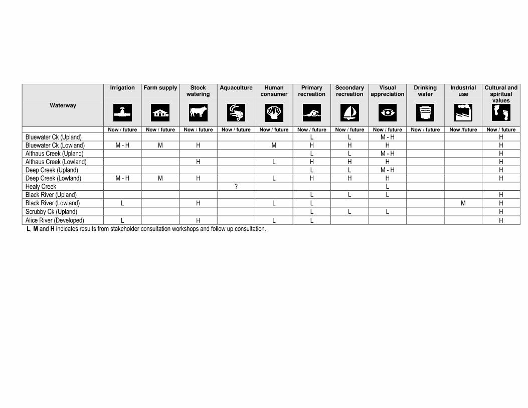
Waterway
Irrigation
Farm supply
Stock watering
Aquaculture
Human consumer
Primary recreation
Secondary recreation
Visual appreciation
Drinking water
Industrial use
Cultural and spiritual values
Now / future Now / future Now / future Now / future Now / future Now / future Now / future Now / future Now / future Now /future Now / future
Bluewater Ck (Upland) L L M - H H
Bluewater Ck (Lowland) M - H M H M H H H H
Althaus Creek (Upland) L L M - H H
Althaus Creek (Lowland) H L H H H H
Deep Creek (Upland) L L M - H H
Deep Creek (Lowland) M - H M H L H H H H
Healy Creek ? L
Black River (Upland) L L L H
Black River (Lowland) L H L L M H
Scrubby Ck (Upland) L L L H
Alice River (Developed) L H L L H
L, M and H indicates results from stakeholder consultation workshops and follow up consultation.

Waterway
Aquaculture
Human consumer
Primary recreation
Secondary recreation
Visual appreciation
Cultural and spiritual values
Estuaries
Crystal Creek H M M - H H H
Lorna Creek H M M - H H H
Ollera Creek H M M - H H H
Scrubby Creek H M M - H H H
Hencamp Creek H M M - H H H
Rollingstone Creek H L H H H
Surveyors Creek H M M - H H H
Wild Boar Creek H M M - H H H
Station Creek H M M - H H H
Saltwater Creek H H L H H H
Cassowary Creek L L L L H
Leichhardt Creek H L H H H
Christmas Creek H L H H H
Two Mile Creek H L H H H
Bluewater Creek H L L H H
Deep Creek H L H H
Healy Creek H L H H H
Black River H L M L H

Waterway
Irrigation
Farm supply
Stock watering
Aquaculture
Human consumer
Primary recreation
Secondary recreation
Visual appreciation
Drinking water
Industrial use
Cultural and spiritual values
Freshwaters
Ross River Basin (Ross River Dam and upstream)
Lake Ross (Ross Dam) L L L L M H M M
Ross River (FrW) L M - H L L L H
Round Mountain Creek L M - H L L L H
Lagoon Creek L M - H L L L H
Plum Tee Creek L M - H L L L H
Central Ck (aka Ross Ck) L M - H L L L H
Sandy Creek L M - H L L L H
Spring Creek L M - H L L L H
Deep Creek L M - H L L L H
Leichhardt Creek L M - H L L L H
Cattle Creek L M - H L L L H
Six Mile Creek L L M L H
Toonpan Lagoon L L M L H
Jimmys Lagoon L L M L H
Four Mile Creek /Flagstone Creek
L L M L H
One Mile Creek/Spring Creek/Lansdowne Creek
L L M L H
Antill Plains Creek L L M L H
Sachs Creek L L M H
Blacksoil Gully/Mt Stuart L L L H
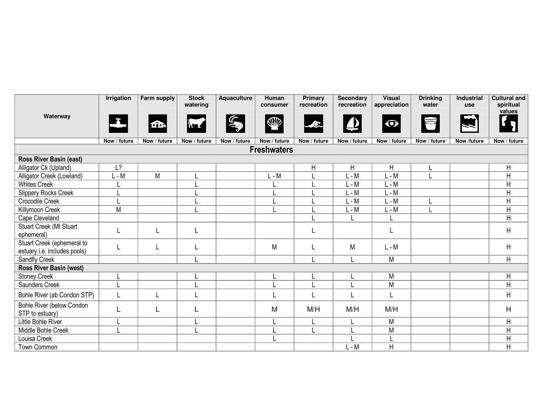
Waterway
Irrigation
Farm supply
Stock watering
Aquaculture
Human consumer
Primary recreation
Secondary recreation
Visual appreciation
Drinking water
Industrial use
Cultural and spiritual values
Now / future Now / future Now / future Now / future Now / future Now / future Now / future Now / future Now / future Now /future Now / future
Freshwaters Ross River Basin (east)
Alligator Ck (Upland) L? H H H L H
Alligator Creek (Lowland) L - M M L L - M L L - M L - M L H
Whites Creek L L L L L - M L - M H
Slippery Rocks Creek L L L L L - M L - M H
Crocodile Creek L L L L L - M L - M L H
Killymoon Creek M L L L L - M L - M L H
Cape Cleveland L L L H
Stuart Creek (Mt Stuart ephemeral)
L L L L L H
Stuart Creek (ephemeral to estuary i.e. includes pools)
L L L M L M L - M H
Sandfly Creek L L L M H
Ross River Basin (west)
Stoney Creek L L L L L M H
Saunders Creek L L L L L M H
Bohle River (ab Condon STP) L L L L L L L H
Bohle River (below Condon STP to estuary)
L L L M M/H M/H M/H H
Little Bohle River L L L L L M H
Middle Bohle Creek L L L L L M H
Louisa Creek L L L H
Town Common L - M H H

Waterway
Irrigation
Farm supply
Stock watering
Aquaculture
Human consumer
Primary recreation
Secondary recreation
Visual appreciation
Drinking water
Industrial use
Cultural and spiritual values
Now / future Now / future Now / future Now / future Now / future Now / future Now / future Now / future Now / future Now /future Now / future
Pallarenda H H H H
Ross River Basin (below the Ross River Dam)
Ross River (below the Dam) M L H H H H H
Ross River Weir Pools (All) M H H H H H
Ross River (Black Weir) H H H H H H H
Ross River (Gleesons Weir) L H H H H H
Ross River (Aplins Weir) L H H H H H
Tributaries from Defence land L L L L H
University (Campus) Creek L L L M H
Lavarack ? Ck with weirs L L L M H
Ross Creek and tributaries H L L H H
Waterway
Aquaculture
Human consumer
Primary recreation
Secondary recreation
Visual appreciation
Industrial use
Cultural and spiritual values
Estuarine Waters
Bohle sub basin (upper) M M L - M H
Bohle sub basin (lower) H H H H
Louisa Creek M M M H
Ross River sub basin H H H M H
Stuart Creek sub basin L H L H H H
Alligator Creek sub basin L H L H H H
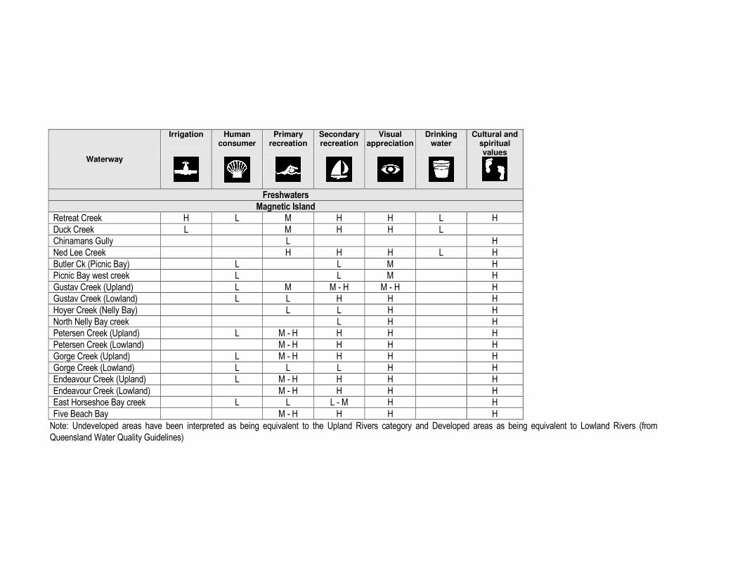
Waterway
Irrigation
Human consumer
Primary recreation
Secondary recreation
Visual appreciation
Drinking water
Cultural and spiritual values
Freshwaters
Magnetic Island
Retreat Creek H L M H H L H
Duck Creek L M H H L
Chinamans Gully L H
Ned Lee Creek H H H L H
Butler Ck (Picnic Bay) L L M H
Picnic Bay west creek L L M H
Gustav Creek (Upland) L M M - H M - H H
Gustav Creek (Lowland) L L H H H
Hoyer Creek (Nelly Bay) L L H H
North Nelly Bay creek L H H
Petersen Creek (Upland) L M - H H H H
Petersen Creek (Lowland) M - H H H H
Gorge Creek (Upland) L M - H H H H
Gorge Creek (Lowland) L L L H H
Endeavour Creek (Upland) L M - H H H H
Endeavour Creek (Lowland) M - H H H H
East Horseshoe Bay creek L L L - M H H
Five Beach Bay M - H H H H
Note: Undeveloped areas have been interpreted as being equivalent to the Upland Rivers category and Developed areas as being equivalent to Lowland Rivers (from
Queensland Water Quality Guidelines)
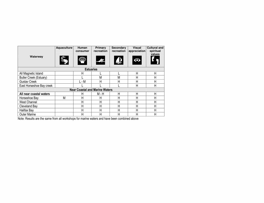
Waterway
Aquaculture
Human consumer
Primary recreation
Secondary recreation
Visual appreciation
Cultural and spiritual values
Estuaries
All Magnetic Island H L L H H
Butler Creek (Estuary) L M M H H
Gustav Creek L - M H H H H
East Horseshoe Bay creek L L L H H
Near Coastal and Marine Waters
All near coastal waters H M - H H H H
Horseshoe Bay M H H H H H
West Channel H H H H H
Cleveland Bay H H H H H
Halifax Bay H H H H H
Outer Marine H H H H H
Note: Results are the same from all workshops for marine waters and have been combined above

Appendix C Aquatic Ecosystem Draft EVs

BLACK-ROSS BASINS WATER QUALITY IMPROVEMENT PLAN (WQIP) DRAFT RESULTS FROM WORKSHOPS - WATERWAY ECOLOGICAL VALUES i.e. ‘AQUATIC ECOSYSTEM’ ENVIRONMENTAL VALUE (EV) The following tables contain draft information on the ecological values of the Black and Ross River Basins, Magnetic Island and adjacent coastal waters in the Black-Ross Water Quality Improvement Plan (WQIP) study area. An earlier draft of this information was provided and reviewed at stakeholder workshops held at:
• Magnetic Island (Arcadia) on 22 July 2008,
• Bluewater on 23 July 2008, and
• Annandale on 24 July 2008. The tables have been updated following the workshops to include stakeholder comments, required further actions and additional information on waterway ecological values. Main required actions/changes to possible HEV waters (and progress on changes made by December 2008) are shown in yellow highlighted text. The WQIP study team is continuing to review/update this information and we welcome further comment on the draft ecological values identified in the tables. A further opportunity for public comment on this material will be provided during the public release of the draft Black-Ross Water Quality Improvement Plan. The following provides further explanation on the ecological values tables (as provided in the stakeholder meetings). A Background
1. The accompanying table focuses only on waterway ecological values (i.e. the ‘aquatic ecosystem’ environmental value). A separate table will record information on human uses/values for waterways in the area.
2. Maintenance of aquatic ecosystems is an EV for all waterways, with the minimum requirement being to maintain their current quality (i.e. ecosystem health).
3. This workshop session aims to firstly identify high ecological value (HEV) waterways that the community wants to protect (refer section B). It also aims to identify other natural assets in non-HEV areas that the community considers ecologically important (refer section C).
B High Ecological Value (HEV) waters

4. The accompanying table summarises fresh, estuarine, and coastal/marine waters in the Magnetic Island workshop area that have been identified as containing potentially high ecological value (HEV) waters. More detail on the definitions of high ecological value and the process used to identify these waterways will be provided in the workshop.
5. Waterways marked in ITALICS (left column of the table) have been assessed as having potentially high ecological value through most/all their area. (Other waterways containing a lesser extent of HEV areas are also identified in the table.)
6. High ecological value waters have been identified using two approaches. � ‘Default’ HEV waters: these are based on existing legislation and designations, and include waters within Wet Tropics World Heritage Area (zones A,
B), National Parks, high value zones within the Marine Park, and Fish Habitat ‘A’ Areas. The table shows these ‘default’ waters (refer top row). � Local studies with technical panel input: EPA and GBRMPA officers, in consultation with Townsville City Creek to Coral, have collated technical
information on ecological values in the Black-Ross WQIP area to identify additional waters which could be considered as high ecological value. As part of this process the team has held two technical panel workshops to assist in identifying HEV waters: a freshwater workshop on 12 October 2007, and an estuarine/coastal/marine waters workshop on 12 March 2008. The approach taken to identify HEV waters and draft results from the assessment will be outlined in the workshop.
7. The table seeks input from workshop participants on these HEV waters, including any suggested changes to boundaries, eg based on impacts from runoff/discharges.
8. The table also provides for stakeholders to nominate other high ecological value waters. C Ecological values in waterways that are not HEV waters
9. Modified (non-HEV) waters may still have a range of important natural assets. Therefore, the table also allows for stakeholders to identify any such natural assets in non-HEV areas. These assets could include key habitat (eg seagrass, coral, mangroves, riparian vegetation), sites known as key breeding areas (eg for fish, turtles), sites known to support particular species, natural processes (eg flows/links between fresh and estuarine waterways) or other locations the workshop attendees consider ecologically important (even if not within HEV waters).
D Recording information on ecological values
10. Workshop attendees will be invited to discuss the ecological values of the waterways. 11. Organisers will record the information provided by workshop attendees. 12. Following the workshop we will prepare draft tables summarising the information provided by participants and will send draft table outputs to workshop
attendees for any feedback/correction.

Explanation of code for coastal/marine waters
Characteristics Symbol
Turtle (nesting, breeding, feeding) T
Dugong (feeding) D
Benthic habitat (Seagrass, reefs and inter-reef areas) B
Coastal habitat (Mangroves, wetlands, etc.) CH
Adjacent to mainland or island National Park NP
Surrounding land use (agriculture, urban, tourism etc) SLU
Special and unique (rare or unusual sites within the GBRWHA) SU
Recreational use (including fishing) R
Heritage values (shipwrecks, lighthouses etc). H
Shipping and ports Sh
Public access (anchorage, jetties, boat ramps, marinas etc) P
Adjacent town A
Species of concern (protected species other than dugongs and turtles, for example whale sharks and Barramundi cod)
S
Tourism sites and transit/access points TS
Summary of Acronyms used
Acronym (listed alphabetically)
Meaning
CP(Z) Conservation Park (zone)
DPA Dugong Protection Area
FHA Fish Habitat Area
HEV High Ecological Value
MNP Marine National Park
NP National Park
SL State Land
SR(Z) Scientific Research (zone)
WHA World Heritage Area

The following table contains draft information on the ecological values of Magnetic Island and adjacent coastal waters in the Black-Ross Water Quality Improvement Plan (WQIP) study area.
Table A: Ecological values of Magnetic Island waterways – note: table proceeds anti-clockwise around island, dealing with fresh and estuarine waters in each catchment, then coastal/marine
High ecological value waters Modified waters
Catchment/ Waterway
Draft HEV waters (location and values – to be shown in workshop maps/presentation)
EVs Workshop input 1: Any changes?
Workshop input 2: Support for proposed HEVs? (Y/N)
Workshop input 3: Any new HEV waters (including location)
Workshop input 4: Basis for listing as potential HEV
Workshop input 5: Support for new HEV? (Y/N)
Workshop input 6: Natural assets in non HEV waters (including location)
Workshop input 7: Support for natural asset (Y/N)
ALL WATERS DEFAULT HEV WATERS (refer to maps)
National Parks (NP), Wet Tropics World Heritage Area (A, B zones), Fish Habitat ‘A’ areas, Forest Reserve (where proposed to become NP), ‘Highly protected areas’ under the Marine Parks Act (eg marine national park, preservation zone, conservation park, buffer), GBR Marine National Park and Preservation zones. (Subject to local technical information, waters in additional areas/designations can also be considered for HEV. These include State Forest, Military Training Areas, Fish Habitat B areas, dugong protection area A/B, other marine park areas, Ramsar areas, Directory of Important Wetlands, etc).
No changes. Default HEVs accepted. Discussed for specific waterways below. General comment (all areas): need to explain how mapping relates to transport/utility easements. (Review undertaken � add statement to mapping that easements not ‘extracted’ from the HEV mapping because of the scale of the mapping.)
Yes Discussed for specific waterways below.
Discussed for specific waterways below.
Discussed for specific waterways below.
Discussed for specific waterways below.
Discussed for specific waterways below.
CATCHMENT – FRESHWATERS AND ESTUARIES (anti-clockwise)
SOUTH WESTERN DRAINING STREAMS (West Point, Young Bay, Bolger Bay etc)
South western freshwaters (Retreat, Duck, Ned Lee and other freshwater Creeks)
HEV waters: Includes upper slopes largely within national Park and State Land (SL) (MI 7). These drain towards the south western side of the island and include sections of Retreat (included within MI 7), Duck (MI10), Chinaman Gully (MI 11) and Ned Lee Creeks (within MI 7). Another unit includes the riverine wetland (MI 9). Values: Creeks in upper slopes (MI 7) are in near natural catchment and instream waters. Riverine units (MI 9, 10, 11) are largely intact seasonal streams with connectivity between NP ranges and river flats/estuaries.
Proposed HEVs accepted, with the following items to review: 1) Review HEV boundaries on GIS relative to underlying cadastral/imagery layers, as slight boundary/alignment variation). (Review undertaken� latest available cadastral layers have been used.) 2) Review local boundaries of MI 7 waters in nature refuges relative to cleared areas. (Review undertaken� localised boundary changes made: reduction in HEV area.)
Yes, with possible changes as noted
No N/A N/A None specified N/A
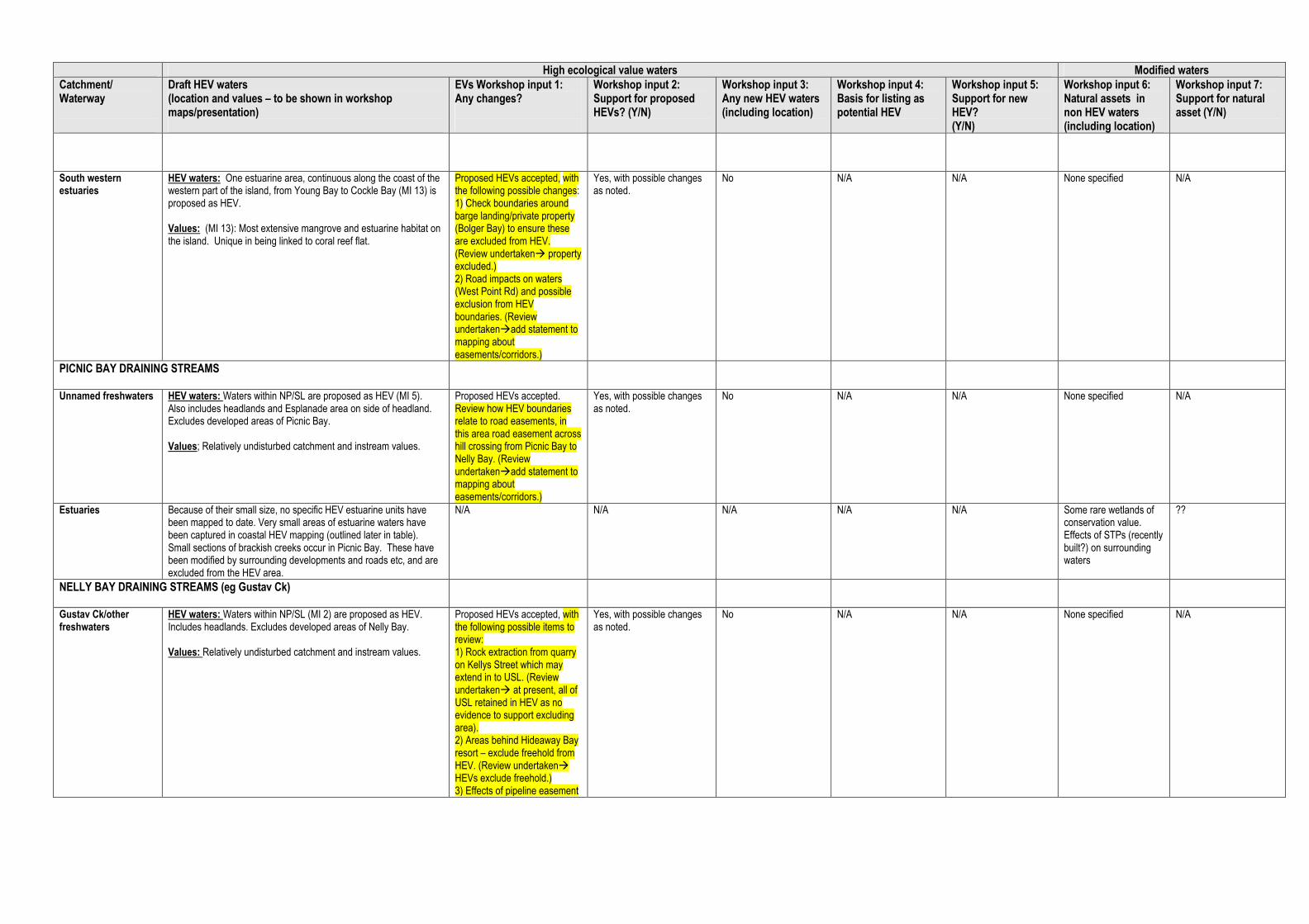
High ecological value waters Modified waters
Catchment/ Waterway
Draft HEV waters (location and values – to be shown in workshop maps/presentation)
EVs Workshop input 1: Any changes?
Workshop input 2: Support for proposed HEVs? (Y/N)
Workshop input 3: Any new HEV waters (including location)
Workshop input 4: Basis for listing as potential HEV
Workshop input 5: Support for new HEV? (Y/N)
Workshop input 6: Natural assets in non HEV waters (including location)
Workshop input 7: Support for natural asset (Y/N)
South western estuaries
HEV waters: One estuarine area, continuous along the coast of the western part of the island, from Young Bay to Cockle Bay (MI 13) is proposed as HEV. Values: (MI 13): Most extensive mangrove and estuarine habitat on the island. Unique in being linked to coral reef flat.
Proposed HEVs accepted, with the following possible changes: 1) Check boundaries around barge landing/private property (Bolger Bay) to ensure these are excluded from HEV. (Review undertaken� property excluded.) 2) Road impacts on waters (West Point Rd) and possible exclusion from HEV boundaries. (Review undertaken�add statement to mapping about easements/corridors.)
Yes, with possible changes as noted.
No N/A N/A None specified N/A
PICNIC BAY DRAINING STREAMS
Unnamed freshwaters HEV waters: Waters within NP/SL are proposed as HEV (MI 5). Also includes headlands and Esplanade area on side of headland. Excludes developed areas of Picnic Bay. Values; Relatively undisturbed catchment and instream values.
Proposed HEVs accepted. Review how HEV boundaries relate to road easements, in this area road easement across hill crossing from Picnic Bay to Nelly Bay. (Review undertaken�add statement to mapping about easements/corridors.)
Yes, with possible changes as noted.
No N/A N/A None specified N/A
Estuaries Because of their small size, no specific HEV estuarine units have been mapped to date. Very small areas of estuarine waters have been captured in coastal HEV mapping (outlined later in table). Small sections of brackish creeks occur in Picnic Bay. These have been modified by surrounding developments and roads etc, and are excluded from the HEV area.
N/A N/A N/A N/A N/A Some rare wetlands of conservation value. Effects of STPs (recently built?) on surrounding waters
??
NELLY BAY DRAINING STREAMS (eg Gustav Ck)
Gustav Ck/other freshwaters
HEV waters: Waters within NP/SL (MI 2) are proposed as HEV. Includes headlands. Excludes developed areas of Nelly Bay. Values: Relatively undisturbed catchment and instream values.
Proposed HEVs accepted, with the following possible items to review: 1) Rock extraction from quarry on Kellys Street which may extend in to USL. (Review undertaken� at present, all of USL retained in HEV as no evidence to support excluding area). 2) Areas behind Hideaway Bay resort – exclude freehold from HEV. (Review undertaken� HEVs exclude freehold.) 3) Effects of pipeline easement
Yes, with possible changes as noted.
No N/A N/A None specified N/A

High ecological value waters Modified waters
Catchment/ Waterway
Draft HEV waters (location and values – to be shown in workshop maps/presentation)
EVs Workshop input 1: Any changes?
Workshop input 2: Support for proposed HEVs? (Y/N)
Workshop input 3: Any new HEV waters (including location)
Workshop input 4: Basis for listing as potential HEV
Workshop input 5: Support for new HEV? (Y/N)
Workshop input 6: Natural assets in non HEV waters (including location)
Workshop input 7: Support for natural asset (Y/N)
in upper catchment near walking track. (Review undertaken: easement was not ‘extracted’ from the HEV mapping because of the scale of the mapping �add statement to mapping about easements/corridors.)
Gustav Ck estuaries Because of their small size, no specific HEV estuarine units have been mapped to date. Very small areas of estuarine waters have been captured in coastal HEV mapping (outlined later in table). Small sections of brackish creeks occur in Nelly Bay. These have been modified by surrounding developments and roads etc, and are excluded from the HEV area.
See above. See above. No N/A N/A None specified N/A
GEOFFREY BAY DRAINING STREAMS (eg Petersen Ck)
Petersen Ck/other freshwaters
HEV waters: Waters within NP/SL (MI 1) are proposed as HEV. Includes headlands. Excludes developed areas of Geoffrey Bay. Values: Relatively undisturbed catchment and instream values.
Proposed HEVs accepted, with the following possible changes: 1) Exclude water tower and associated disturbed area from HEV. (Review undertaken� disturbed area has been removed from HEV.)
Yes, with possible changes as noted.
Yes. Include part of the defence lands on Bremner Point as HEV (excluding housing etc). (Review undertaken� new area added.)
Potentially natural waterways/catchment.
Yes – subject to further input from Defence.
None specified N/A
Petersen Ck estuaries Because of their small size, no specific HEV estuarine units have been mapped to date. Very small areas of estuarine waters have been captured in coastal HEV mapping (outlined later in table). Small sections of brackish creeks occur in Geoffrey Bay. These have been modified by surrounding developments and roads etc, and are excluded from the HEV area.
No changes (proposed HEVs accepted).
Yes. As above for defence lands.
As above for defence lands.
As above for defence lands.
None specified N/A
NORTH EASTERN DRAINING STREAMS (Radical Bay, Arthur Bay etc)
Freshwaters HEV waters; Waters within NP/SL (MI 19) are proposed as HEV. The HEV area covers all the catchment but excludes the section of stream, draining to Arthur Bay, downstream of the road causeway and the freehold lots at Radical Bay, which were previously used for the Radical Bay Resort, as well as the Radical Bay Road. Values: Relatively undisturbed catchment and instream values.
Proposed HEVs accepted, however need to review boundaries relative to roads/tracks from Arcadia-Horseshoe Bay to The Forts. Investigate the exclusion of a disused eroded track from The Forts to Florence Bay from HEV. (Review undertaken: easement was not ‘extracted’ from the HEV mapping because of the scale of the mapping �add statement to mapping about easements/corridors.)
Yes, with possible changes as noted.
No N/A N/A None specified N/A

High ecological value waters Modified waters
Catchment/ Waterway
Draft HEV waters (location and values – to be shown in workshop maps/presentation)
EVs Workshop input 1: Any changes?
Workshop input 2: Support for proposed HEVs? (Y/N)
Workshop input 3: Any new HEV waters (including location)
Workshop input 4: Basis for listing as potential HEV
Workshop input 5: Support for new HEV? (Y/N)
Workshop input 6: Natural assets in non HEV waters (including location)
Workshop input 7: Support for natural asset (Y/N)
Estuaries Because of their small size, no specific HEV estuarine units have been mapped to date. Very small areas of estuarine waters have been captured in coastal HEV mapping (outlined later in table). The small brackish creek in Arthur Bay has been modified by surrounding development and road causeway, and is not included in the HEV area. Freehold lots at Radical Bay have also been excluded.
See above. See above. See above. See above. See above. See above. See above.
HORSESHOE BAY DRAINING STREAMS (eg Gorge Ck)
Freshwaters, including Gorge Ck, Endeavour Ck
HEV waters; Waters within NP/SL (MI 16) are proposed as HEV. This excludes the more downstream developed sections near Horseshoe Bay. Waters in the Horseshoe Bay lagoon proposed HEV area (MI 22) include a large parcel within reserve and Conservation Park (core area), and some optional smaller adjoining parcels. Input is sought on whether all parcels warrant identification as HEV. Values: (MI 16) Relatively undisturbed catchment and instream values in upper reaches. The lagoon area (MI 22) is a large wetland that supports significant vegetation communities, birdlife and other flora and fauna. Similar habitat is not available elsewhere on the island in such an extensive wetland.
Waters within upper reaches (including USL) supported, subject to reviewing: 1) Disused pipeline above sports field towards the Forts (has caused erosion.) (Review undertaken: easement was not ‘extracted’ from the HEV mapping because of the scale of the mapping �add statement to mapping about easements/corridors.) 2) The water tank and easement (above main road). (Review undertaken�water tank excluded from HEV.) 3) A section of state land lots 1USL51543 and 1USL51469 with severe erosion occurring adjacent to roadway and development. (Review undertaken� this area has been removed from HEV.) 4) Roadway to The Forts through HEV area needs to be reviewed. (Review undertaken: road was not ‘extracted’ from the HEV mapping because of the scale of the mapping �add statement to mapping about easements/corridors.) 5) Disused pipeline following gully above Swensen Street requires further review. (Review undertaken: disused pipeline was not ‘extracted’ from the HEV mapping because of the scale of the mapping �add statement to mapping about easements/corridors.)
Yes, subject to further review of boundaries noted.
No N/A N/A A freehold lot and lease hold lot are present near White Lady Bay in Horseshoe Bay, associated with an oyster farm. Nearby two small in-holdings occur with the National Park boundaries of MI16 (153EP626 and 166EP626). None of these lots have been included within the HEV area, although their condition is likely to be good as they do not appear to have been developed.
N/A (identified after workshop)
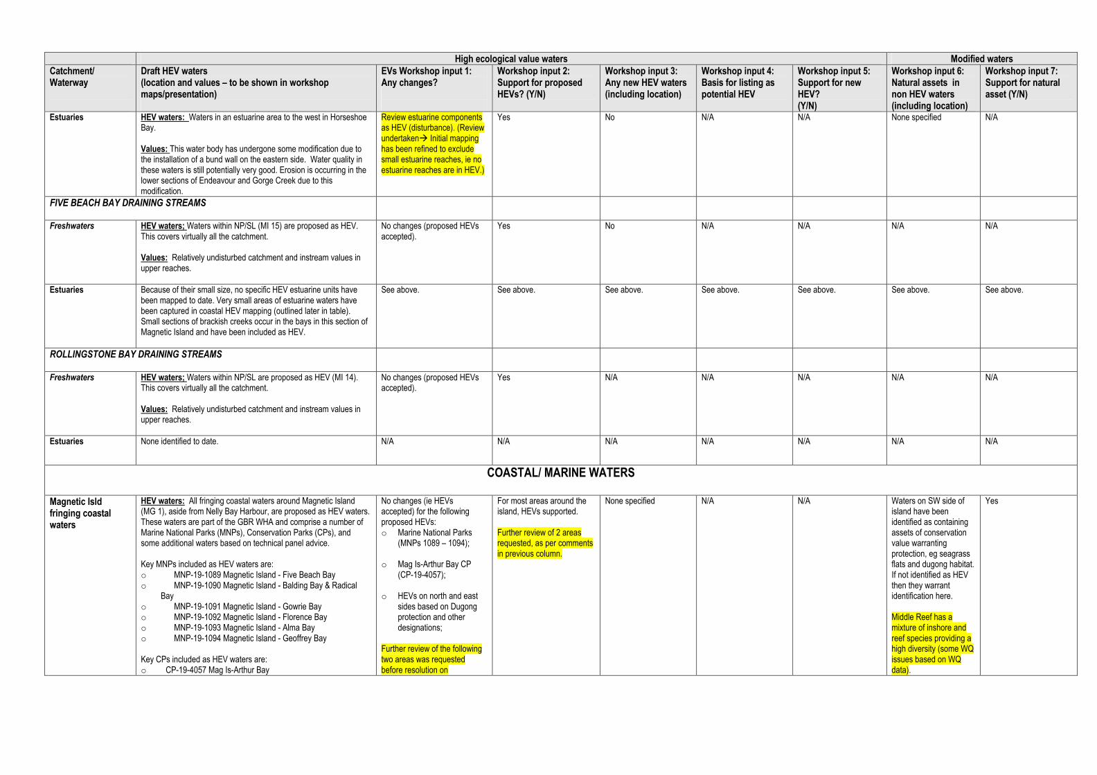
High ecological value waters Modified waters
Catchment/ Waterway
Draft HEV waters (location and values – to be shown in workshop maps/presentation)
EVs Workshop input 1: Any changes?
Workshop input 2: Support for proposed HEVs? (Y/N)
Workshop input 3: Any new HEV waters (including location)
Workshop input 4: Basis for listing as potential HEV
Workshop input 5: Support for new HEV? (Y/N)
Workshop input 6: Natural assets in non HEV waters (including location)
Workshop input 7: Support for natural asset (Y/N)
Estuaries HEV waters: Waters in an estuarine area to the west in Horseshoe Bay. Values: This water body has undergone some modification due to the installation of a bund wall on the eastern side. Water quality in these waters is still potentially very good. Erosion is occurring in the lower sections of Endeavour and Gorge Creek due to this modification.
Review estuarine components as HEV (disturbance). (Review undertaken� Initial mapping has been refined to exclude small estuarine reaches, ie no estuarine reaches are in HEV.)
Yes No N/A N/A None specified N/A
FIVE BEACH BAY DRAINING STREAMS
Freshwaters HEV waters; Waters within NP/SL (MI 15) are proposed as HEV. This covers virtually all the catchment. Values: Relatively undisturbed catchment and instream values in upper reaches.
No changes (proposed HEVs accepted).
Yes No N/A N/A N/A N/A
Estuaries Because of their small size, no specific HEV estuarine units have been mapped to date. Very small areas of estuarine waters have been captured in coastal HEV mapping (outlined later in table). Small sections of brackish creeks occur in the bays in this section of Magnetic Island and have been included as HEV.
See above.
See above.
See above.
See above.
See above.
See above.
See above.
ROLLINGSTONE BAY DRAINING STREAMS
Freshwaters HEV waters; Waters within NP/SL are proposed as HEV (MI 14). This covers virtually all the catchment. Values: Relatively undisturbed catchment and instream values in upper reaches.
No changes (proposed HEVs accepted).
Yes N/A N/A N/A N/A N/A
Estuaries None identified to date.
N/A
N/A N/A N/A N/A N/A N/A
COASTAL/ MARINE WATERS
Magnetic Isld fringing coastal waters
HEV waters: All fringing coastal waters around Magnetic Island (MG 1), aside from Nelly Bay Harbour, are proposed as HEV waters. These waters are part of the GBR WHA and comprise a number of Marine National Parks (MNPs), Conservation Parks (CPs), and some additional waters based on technical panel advice. Key MNPs included as HEV waters are: o MNP-19-1089 Magnetic Island - Five Beach Bay o MNP-19-1090 Magnetic Island - Balding Bay & Radical
Bay o MNP-19-1091 Magnetic Island - Gowrie Bay o MNP-19-1092 Magnetic Island - Florence Bay o MNP-19-1093 Magnetic Island - Alma Bay o MNP-19-1094 Magnetic Island - Geoffrey Bay Key CPs included as HEV waters are: o CP-19-4057 Mag Is-Arthur Bay
No changes (ie HEVs accepted) for the following proposed HEVs: o Marine National Parks
(MNPs 1089 – 1094); o Mag Is-Arthur Bay CP
(CP-19-4057); o HEVs on north and east
sides based on Dugong protection and other designations;
Further review of the following two areas was requested before resolution on
For most areas around the island, HEVs supported. Further review of 2 areas requested, as per comments in previous column.
None specified N/A N/A Waters on SW side of island have been identified as containing assets of conservation value warranting protection, eg seagrass flats and dugong habitat. If not identified as HEV then they warrant identification here. Middle Reef has a mixture of inshore and reef species providing a high diversity (some WQ issues based on WQ data).
Yes

High ecological value waters Modified waters
Catchment/ Waterway
Draft HEV waters (location and values – to be shown in workshop maps/presentation)
EVs Workshop input 1: Any changes?
Workshop input 2: Support for proposed HEVs? (Y/N)
Workshop input 3: Any new HEV waters (including location)
Workshop input 4: Basis for listing as potential HEV
Workshop input 5: Support for new HEV? (Y/N)
Workshop input 6: Natural assets in non HEV waters (including location)
Workshop input 7: Support for natural asset (Y/N)
o CP-19-4058 Pallarenda – Cleveland Bay (part - adjacent Mag Is = MG 1)
Additionally, the HEV waters include waters under Dugong Protection Area (Rollingstone Bay - north west side of Island), and seagrass meadows on the south side of the Island (partly within Conservation Park), and some habitat protection areas (based on technical panel advice). Values: 1) MNPs: T D B NP S TS (refer separate code explanation table after this table)
These zones include 2 bioregions (NA3 and RE3) and afford protection to several bays adjacent to Magnetic Island National Park and within the Cleveland Bay – Magnetic Island DPA ‘A’ Zone important for dugongs and is an important green turtle foraging habitat. The zone in Five Beach Bay (MNP-19-1089) builds on a pre-existing MNPZ simplifying the boundary to assist in compliance and protecting the fringing coral reef within the Bay. White Rock, which was identified as an important line fishing location through submissions on the GBR zoning plan, has not been included in the zone. MNP-19-1090 builds on a pre-existing MNPZ at Balding Bay to include Radical Bay, which was previously a CPZ. Gowrie Bay (MNP-19-1091), Florence Bay (MNP-19-1092) and Alma Bay (MNP-19-1093) have been zoned MNPZ to afford greater protection to the well-developed fringing reefs. MNP-19-1094 reflects the previous MNPZ at Geoffrey Bay. The zone recognises these bays for their non-extractive tourism and recreational values. The boundaries of these zones have been configured to minimise the potential impact on the recreational line fishery by allowing these activities to continue on most of the headlands adjacent to the bays, raised as important through submissions on the GBR zoning plan. 2) CPs CP-19-4057:Magnetic Island - Arthur Bay T B NP TS The zone recognises the conservation values of Arthur Bay whilst also recognising its importance to local residents and visitors as a location for limited line fishing and spearfishing. The zone complements the adjacent Magnetic Island National Park, the Cleveland Bay – Magnetic Island DPA ‘A’ Zone, protects the fringing reefs and important green turtle foraging habitat.
CP-19-4058:Pallarenda / Cleveland Bay T D B CH R P A S The zone builds substantially on a pre-existing CPZ at Pallarenda and extends the zone to Magnetic Island, protecting seagrass beds and significant dugong and green turtle foraging habitat. The zone
boundaries in these areas: 1) Proposed HEV waters off Nelly Bay beach – some participants questioned whether there was evidence of impacts from Nelly Bay Harbour on these HEV waters that would require boundary change. Study team to review available information before making decision on need for change. (Review undertaken� no boundary change proposed.) 2) The HEV area of Cockle Bay (SW side of Island – part of CP-19-4058 Pallarenda – Cleveland Bay). Participants discussed whether the current mangrove/mud dominated condition favouring seagrass and dugong was the original habitat condition compared with a more ‘coral-dominated’ substrate. Some participants considered that in some locations substrate was changing back to coral (eg Cod Hole re-emergence) (Review undertaken� no change to HEV area.)
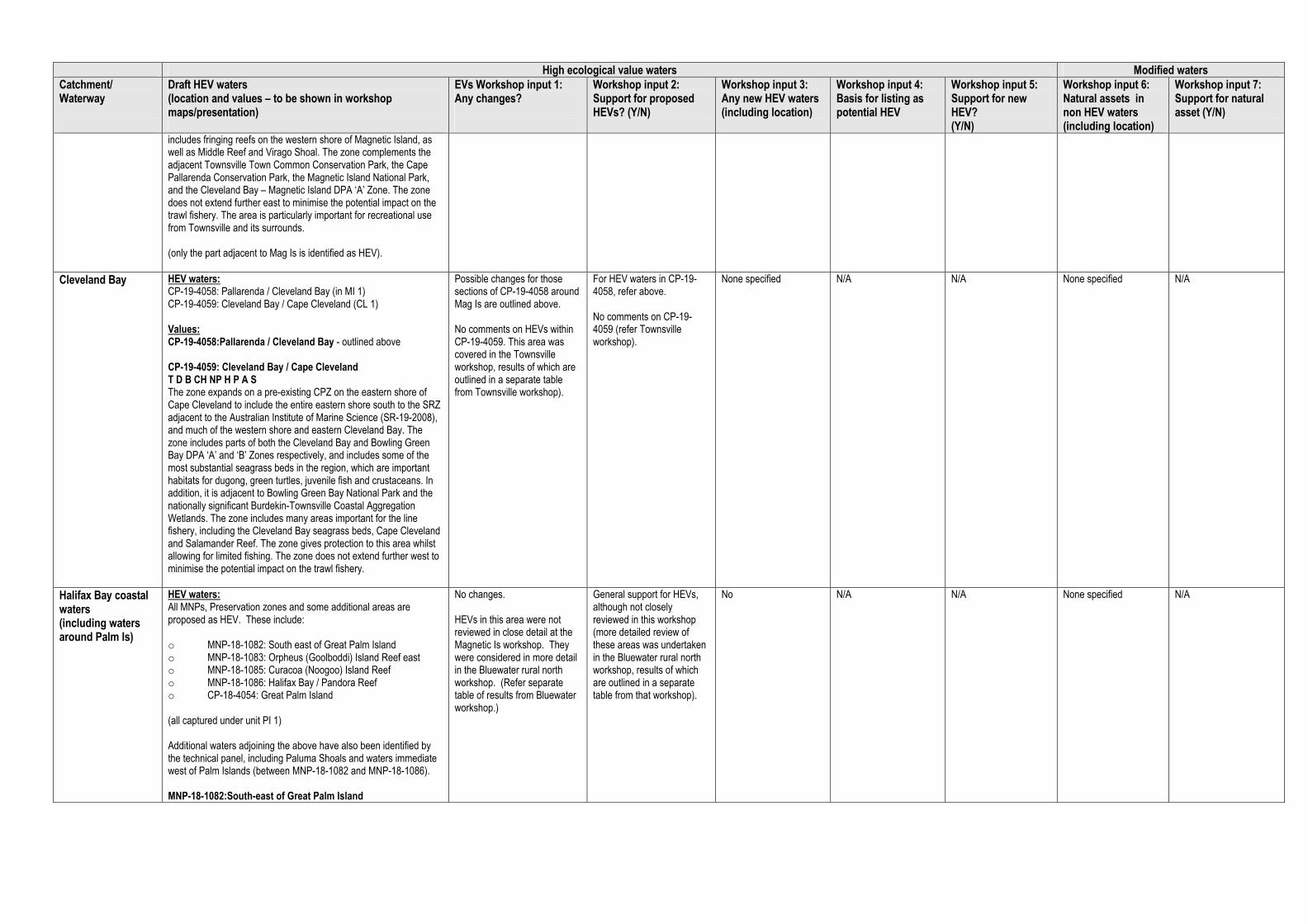
High ecological value waters Modified waters
Catchment/ Waterway
Draft HEV waters (location and values – to be shown in workshop maps/presentation)
EVs Workshop input 1: Any changes?
Workshop input 2: Support for proposed HEVs? (Y/N)
Workshop input 3: Any new HEV waters (including location)
Workshop input 4: Basis for listing as potential HEV
Workshop input 5: Support for new HEV? (Y/N)
Workshop input 6: Natural assets in non HEV waters (including location)
Workshop input 7: Support for natural asset (Y/N)
includes fringing reefs on the western shore of Magnetic Island, as well as Middle Reef and Virago Shoal. The zone complements the adjacent Townsville Town Common Conservation Park, the Cape Pallarenda Conservation Park, the Magnetic Island National Park, and the Cleveland Bay – Magnetic Island DPA ‘A’ Zone. The zone does not extend further east to minimise the potential impact on the trawl fishery. The area is particularly important for recreational use from Townsville and its surrounds. (only the part adjacent to Mag Is is identified as HEV).
Cleveland Bay HEV waters: CP-19-4058: Pallarenda / Cleveland Bay (in MI 1) CP-19-4059: Cleveland Bay / Cape Cleveland (CL 1) Values: CP-19-4058:Pallarenda / Cleveland Bay - outlined above CP-19-4059: Cleveland Bay / Cape Cleveland T D B CH NP H P A S The zone expands on a pre-existing CPZ on the eastern shore of Cape Cleveland to include the entire eastern shore south to the SRZ adjacent to the Australian Institute of Marine Science (SR-19-2008), and much of the western shore and eastern Cleveland Bay. The zone includes parts of both the Cleveland Bay and Bowling Green Bay DPA ‘A’ and ‘B’ Zones respectively, and includes some of the most substantial seagrass beds in the region, which are important habitats for dugong, green turtles, juvenile fish and crustaceans. In addition, it is adjacent to Bowling Green Bay National Park and the nationally significant Burdekin-Townsville Coastal Aggregation Wetlands. The zone includes many areas important for the line fishery, including the Cleveland Bay seagrass beds, Cape Cleveland and Salamander Reef. The zone gives protection to this area whilst allowing for limited fishing. The zone does not extend further west to minimise the potential impact on the trawl fishery.
Possible changes for those sections of CP-19-4058 around Mag Is are outlined above. No comments on HEVs within CP-19-4059. This area was covered in the Townsville workshop, results of which are outlined in a separate table from Townsville workshop).
For HEV waters in CP-19-4058, refer above. No comments on CP-19-4059 (refer Townsville workshop).
None specified N/A N/A None specified N/A
Halifax Bay coastal waters (including waters around Palm Is)
HEV waters: All MNPs, Preservation zones and some additional areas are proposed as HEV. These include: o MNP-18-1082: South east of Great Palm Island o MNP-18-1083: Orpheus (Goolboddi) Island Reef east o MNP-18-1085: Curacoa (Noogoo) Island Reef o MNP-18-1086: Halifax Bay / Pandora Reef o CP-18-4054: Great Palm Island (all captured under unit PI 1) Additional waters adjoining the above have also been identified by the technical panel, including Paluma Shoals and waters immediate west of Palm Islands (between MNP-18-1082 and MNP-18-1086). MNP-18-1082:South-east of Great Palm Island
No changes. HEVs in this area were not reviewed in close detail at the Magnetic Is workshop. They were considered in more detail in the Bluewater rural north workshop. (Refer separate table of results from Bluewater workshop.)
General support for HEVs, although not closely reviewed in this workshop (more detailed review of these areas was undertaken in the Bluewater rural north workshop, results of which are outlined in a separate table from that workshop).
No N/A N/A None specified N/A

High ecological value waters Modified waters
Catchment/ Waterway
Draft HEV waters (location and values – to be shown in workshop maps/presentation)
EVs Workshop input 1: Any changes?
Workshop input 2: Support for proposed HEVs? (Y/N)
Workshop input 3: Any new HEV waters (including location)
Workshop input 4: Basis for listing as potential HEV
Workshop input 5: Support for new HEV? (Y/N)
Workshop input 6: Natural assets in non HEV waters (including location)
Workshop input 7: Support for natural asset (Y/N)
B SU H The zone includes 3 bioregions (NA3, NB3 and NB5), and includes areas of both Halifax Bay and the Palm Islands special and unique areas, which are of high conservation value owing to their ecological importance and cultural significance. The zone includes shoal areas, important transitory habitat for fishes moving from coastal and inshore nursery grounds to offshore reef and inter-reef habitats. The zone has been placed to exclude Albino, Chilcott, Hayman and Paluma Rocks to the south-east of Great Palm Island as maintenance of access to these rocks for mainly recreational line fishing was raised in submissions on the GBR zoning plan. The potential impact on the recreational line fishery has also been minimised by excluding shoal areas to the south and east of the zone. The zone has also been placed to exclude areas to the east, north-east and west to minimise the potential impact on the trawl fishery. MNP-18-1083: Orpheus (Goolboddi) Island Reef east (18-049d) B NP SU H The zone includes 2 bioregions (NB3 and RHC), and forms part of the Palm Islands special and unique area. The zone builds on a pre-existing MNPZ to simplify the boundary to assist in compliance. The zone complements the adjacent Orpheus Island National Park, its Indigenous cultural heritage values, and protects fringing reefs on the island’s eastern shore. MNP-18-1085: Curacoa (Noogoo) Island Reef (18-052) B SU H S The zone includes 2 bioregions (NB3 and RHC), and is included in the Palm Islands special and unique area. The zone has been established to protect the fringing reef of Curacoa Island and is limited in placement due to the need to adequately protect the reef bioregion RHC. MNP-18-1086: Halifax Bay / Pandora Reef (18-051) T B CH NP R S The zone includes 2 bioregions (NA3 and RE3), shallow water seagrass beds that provide important foraging habitat for green turtles, and complements the adjacent nationally-significant Herbert River Floodplain, Bambaroo Aggregation Wetlands and the Halifax Bay Wetlands National Park. The zone provides some connectivity between Pandora Reef and inshore habitats, estuaries and wetlands. The zone has been placed to avoid the small reefs and inshore shoals adjacent to and north and south of Crystal Creek to minimise the potential impact on the line and net fisheries. The northern inshore boundary of the zone was revised to reflect submissions highlighting the importance of area adjacent to Palm Creek for recreational line fishing. The zone is limited in placement due to the need to adequately protect the heavily used non-reef bioregion NA3, however does not extend further east to minimise the potential impact on the trawl fishery and on users of the small islands to the south-west of the Palm Islands Group.
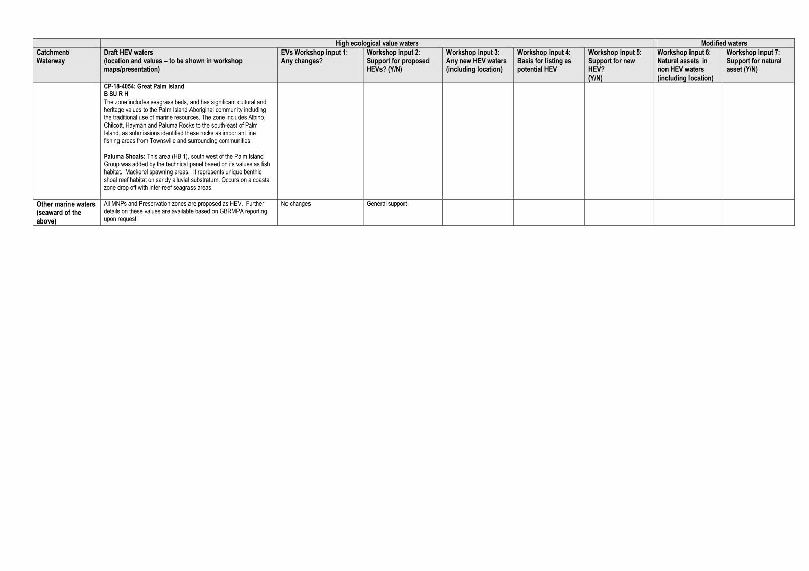
High ecological value waters Modified waters
Catchment/ Waterway
Draft HEV waters (location and values – to be shown in workshop maps/presentation)
EVs Workshop input 1: Any changes?
Workshop input 2: Support for proposed HEVs? (Y/N)
Workshop input 3: Any new HEV waters (including location)
Workshop input 4: Basis for listing as potential HEV
Workshop input 5: Support for new HEV? (Y/N)
Workshop input 6: Natural assets in non HEV waters (including location)
Workshop input 7: Support for natural asset (Y/N)
CP-18-4054: Great Palm Island B SU R H The zone includes seagrass beds, and has significant cultural and heritage values to the Palm Island Aboriginal community including the traditional use of marine resources. The zone includes Albino, Chilcott, Hayman and Paluma Rocks to the south-east of Palm Island, as submissions identified these rocks as important line fishing areas from Townsville and surrounding communities. Paluma Shoals: This area (HB 1), south west of the Palm Island Group was added by the technical panel based on its values as fish habitat. Mackerel spawning areas. It represents unique benthic shoal reef habitat on sandy alluvial substratum. Occurs on a coastal zone drop off with inter-reef seagrass areas.
Other marine waters (seaward of the above)
All MNPs and Preservation zones are proposed as HEV. Further details on these values are available based on GBRMPA reporting upon request.
No changes General support

The following table contains draft information on the ecological values of waterways in the rural workshop area (Crystal Creek to Black River and upper Ross River and adjacent coastal waters).
Table B: Ecological values of “Rural” Workshop area waterways – note: table proceeds broadly north to south through each catchment, dealing with fresh and estuarine waters, then coastal/marine waters
High ecological value waters Modified waters
Catchment/ Waterway (broadly north – south)
Draft HEV waters (location and values – to be shown in workshop maps/presentation)
Workshop input 1: Any changes?
Workshop input 2: Support for proposed HEVs? (Y/N)
Workshop input 3: Any new HEV waters (including location)
Workshop input 4: Basis for listing as potential HEV
Workshop input 5: Support for new HEV? (Y/N)
Workshop input 6: Natural assets in non HEV waters (including location)
Workshop input 7: Support for natural asset (Y/N)
ALL WATERS
DEFAULT HEV WATERS (refer to maps)
National Parks (NP), Wet Tropics World Heritage Area (A, B zones), Fish Habitat ‘A’ areas, Forest Reserve (where proposed to become NP), ‘Highly protected areas’ under the Marine Parks Act (eg marine national park, preservation zone, conservation park, buffer), GBR Marine National Park and Preservation zones. (Subject to local technical information, waters in additional areas/designations can also be considered for HEV. These include State Forest, Military Training Areas, Fish Habitat B areas, dugong protection area A/B, other marine park areas, Ramsar areas, Directory of Important Wetlands, etc).
No changes. Default HEVs accepted. Discussed for specific waterways below. General comment (all areas): need to explain how mapping relates to transport/utility easements. (Review undertaken � add statement to mapping that easements not ‘extracted’ from the HEV mapping because of the scale of the mapping.)
Discussed for specific waterways below.
Discussed for specific waterways below.
Discussed for specific waterways below.
Discussed for specific waterways below.
Discussed for specific waterways below.
Discussed for specific waterways below.
CATCHMENT - FRESHWATERS AND ESTUARIES
BLACK RIVER BASIN
CRYSTAL CREEK
Crystal Ck freshwaters
HEV waters: Three main units, including upper reaches of Crystal Ck and tributaries, eg Little Crystal and Ethel Creeks (all within mapping unit CC 1). These are largely within National Park (NP), and World Heritage Area. Excludes Paluma township and Crystal Ck downstream of pipeline from Paluma Dam (interbasin water transfer). Values: High values as recognised by inclusion in Wet Tropics World Heritage Area (WHA). High biodiversity values and largely natural catchment and drainage from within NP areas. (Crystal Creek reach with altered flows from Paluma pipeline excluded).
No changes to the basis/approach of defining HEV boundaries relative to pipeline from Paluma. Three items for review: 1) Review pipeline easement layer relative to HEV boundaries (Review undertaken�add statement to mapping about easements/corridors) 2) Crystal Ck swimming hole and Yanks Gully eroded area to be excluded (Review
Yes, with boundary review as noted. Comment made that water quality effects may continue downstream of swimming holes, but at present main exclusion is around swimming hole
No N/A N/A Crystal Ck falls are located in the gorge upstream of the water intake weir and infrastructure but downstream of the water transfer (i.e. within flow-affected non HEV areas) and contains areas with functional and biodiversity value that need protection. Causeway crossing downstream section of Little Crystal Creek (outside HEV area) has been identified as fish
Yes

High ecological value waters Modified waters
Catchment/ Waterway (broadly north – south)
Draft HEV waters (location and values – to be shown in workshop maps/presentation)
Workshop input 1: Any changes?
Workshop input 2: Support for proposed HEVs? (Y/N)
Workshop input 3: Any new HEV waters (including location)
Workshop input 4: Basis for listing as potential HEV
Workshop input 5: Support for new HEV? (Y/N)
Workshop input 6: Natural assets in non HEV waters (including location)
Workshop input 7: Support for natural asset (Y/N)
undertaken� area already excluded) 3) Little Crystal Ck swimming hole to be excluded from HEV area? (Review undertaken�area is too small for mapping scale).
barrier.
Crystal Ck estuary
HEV waters: Three main units, including the main channel and some adjacent wetlands. These are: the main channel (CC 12), northern side of Crystal Ck (CC 13), which connects Crystal Ck to the Insulator Ck system and other wetlands to the north (eg Halifax Bay NP); and southern side of Crystal Ck (unit CC 14), connecting to Lorna Ck system. Values: Important area of connected estuarine habitat with links to upland HEV waters and downstream coastal HEV areas. Also connects to remnant terrestrial habitat to the west, including mahogany glider habitat.
No changes (HEVs accepted, including main channel) Comment made that the boundary of council areas (Townsville and Hinchinbrook Shire) occurs mid channel - implications for management. (ie has WQIP project team consulted with adjoining Council?)
Yes No N/A N/A None specified N/A
LORNA CREEK
Lorna Ck freshwaters
No HEV waters identified to date. N/A N/A No N/A N/A None specified N/A
Lorna Ck estuary
HEV waters: Units on the north bank (LC 4) and south bank (LC 5) are proposed as HEV. This HEV area includes the estuary main channel, and feedback is invited on the inclusion of the main channel in the HEV area. Values: Unit LC 4 connects to Crystal Creek and extensive wetlands further north. It also connects with some riverine tributaries and palustrine wetland (swale swamps). Unit LC 5 provides connectivity to Ollera Creek through large area of remnant habitat and is adjacent to freshwater palustrine wetlands (swale swamps). The estuary channel provides intact deep water estuarine tidal habitat.
No changes (HEVs accepted, including main channel)
Yes No N/A N/A None specified N/A
OLLERA CREEK
Ollera Ck freshwaters
HEV waters: Three units, including waters within the Wet Tropics WHA (unit OL 4), an area on the north side of Ollera Ck, east of Highway (unit OL 1), and an area on the south side of Ollera Ck, east of highway (also in unit OL 1). The latter two were both identified in the technical panel workshop. Values: The area within WHA (OL 4) is largely pristine stream with high biodiversity values. A Forestry Reserve (used for orchards/horticulture) occurs on the southern bank of Ollera Creek at the very downstream section of the WHA. This area is included in the WTWHA but has been excluded from the HEV. The areas outside the WHA (OL 1) include large areas of remnant coastal habitat identified under the Veg Management Act and Essential habitat (for Mahogany glider) - Endangered RE 7.3.8b. This area is sometimes referred
HEVs generally accepted, with one item for review. Comment made that there is a small barrier to fish in Ollera Creek – check location relative to HEV boundaries. (Review undertaken� HEV waters exclude main Ollera channel.).
Yes, with boundary review as noted.
No N/A N/A None specified N/A
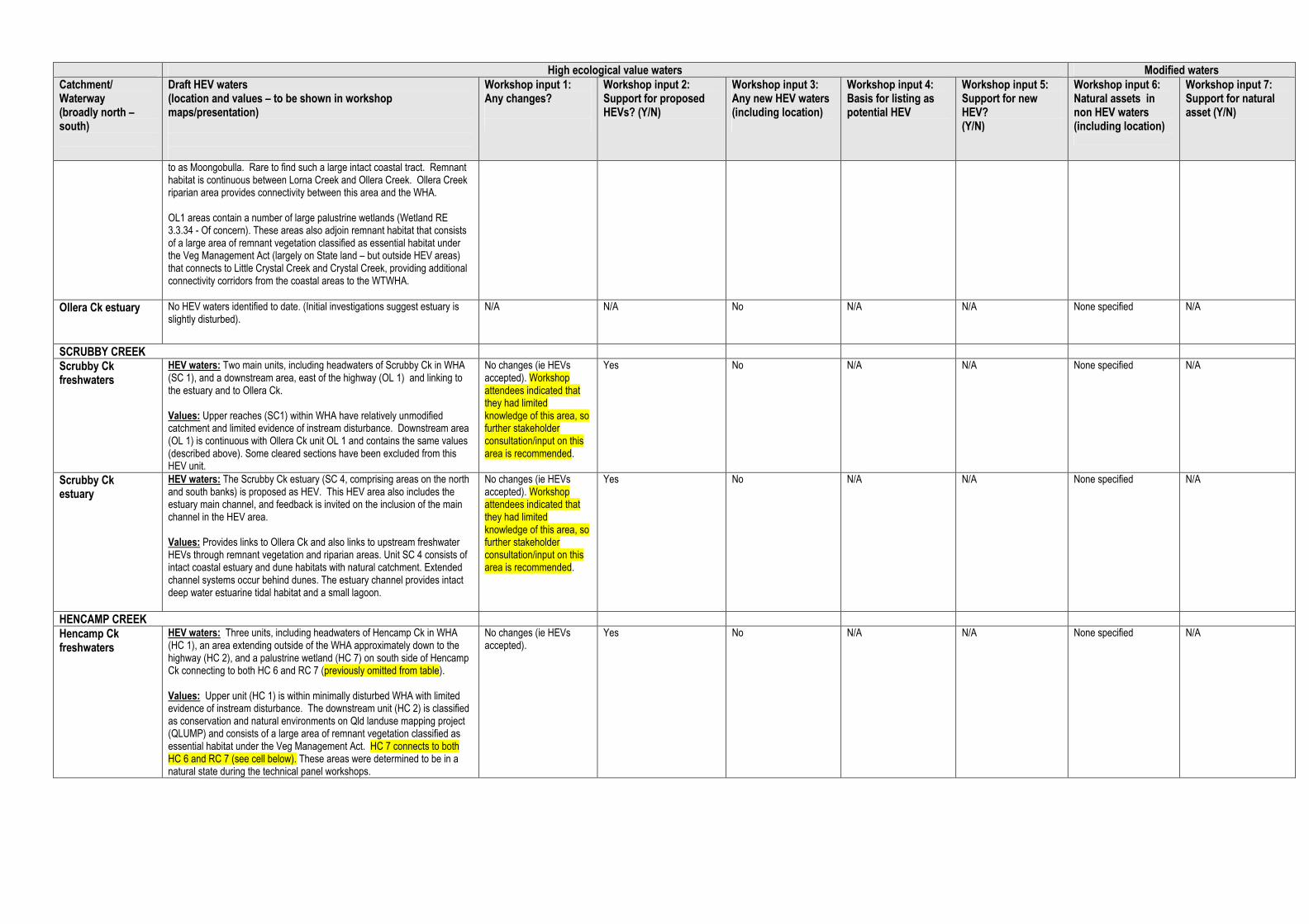
High ecological value waters Modified waters
Catchment/ Waterway (broadly north – south)
Draft HEV waters (location and values – to be shown in workshop maps/presentation)
Workshop input 1: Any changes?
Workshop input 2: Support for proposed HEVs? (Y/N)
Workshop input 3: Any new HEV waters (including location)
Workshop input 4: Basis for listing as potential HEV
Workshop input 5: Support for new HEV? (Y/N)
Workshop input 6: Natural assets in non HEV waters (including location)
Workshop input 7: Support for natural asset (Y/N)
to as Moongobulla. Rare to find such a large intact coastal tract. Remnant habitat is continuous between Lorna Creek and Ollera Creek. Ollera Creek riparian area provides connectivity between this area and the WHA. OL1 areas contain a number of large palustrine wetlands (Wetland RE 3.3.34 - Of concern). These areas also adjoin remnant habitat that consists of a large area of remnant vegetation classified as essential habitat under the Veg Management Act (largely on State land – but outside HEV areas) that connects to Little Crystal Creek and Crystal Creek, providing additional connectivity corridors from the coastal areas to the WTWHA.
Ollera Ck estuary
No HEV waters identified to date. (Initial investigations suggest estuary is slightly disturbed).
N/A N/A No N/A N/A None specified N/A
SCRUBBY CREEK
Scrubby Ck freshwaters
HEV waters: Two main units, including headwaters of Scrubby Ck in WHA (SC 1), and a downstream area, east of the highway (OL 1) and linking to the estuary and to Ollera Ck. Values: Upper reaches (SC1) within WHA have relatively unmodified catchment and limited evidence of instream disturbance. Downstream area (OL 1) is continuous with Ollera Ck unit OL 1 and contains the same values (described above). Some cleared sections have been excluded from this HEV unit.
No changes (ie HEVs accepted). Workshop attendees indicated that they had limited knowledge of this area, so further stakeholder consultation/input on this area is recommended.
Yes No N/A N/A None specified N/A
Scrubby Ck estuary
HEV waters: The Scrubby Ck estuary (SC 4, comprising areas on the north and south banks) is proposed as HEV. This HEV area also includes the estuary main channel, and feedback is invited on the inclusion of the main channel in the HEV area. Values: Provides links to Ollera Ck and also links to upstream freshwater HEVs through remnant vegetation and riparian areas. Unit SC 4 consists of intact coastal estuary and dune habitats with natural catchment. Extended channel systems occur behind dunes. The estuary channel provides intact deep water estuarine tidal habitat and a small lagoon.
No changes (ie HEVs accepted). Workshop attendees indicated that they had limited knowledge of this area, so further stakeholder consultation/input on this area is recommended.
Yes No N/A N/A None specified N/A
HENCAMP CREEK
Hencamp Ck freshwaters
HEV waters: Three units, including headwaters of Hencamp Ck in WHA (HC 1), an area extending outside of the WHA approximately down to the highway (HC 2), and a palustrine wetland (HC 7) on south side of Hencamp Ck connecting to both HC 6 and RC 7 (previously omitted from table). Values: Upper unit (HC 1) is within minimally disturbed WHA with limited evidence of instream disturbance. The downstream unit (HC 2) is classified as conservation and natural environments on Qld landuse mapping project (QLUMP) and consists of a large area of remnant vegetation classified as essential habitat under the Veg Management Act. HC 7 connects to both HC 6 and RC 7 (see cell below). These areas were determined to be in a natural state during the technical panel workshops.
No changes (ie HEVs accepted).
Yes No N/A N/A None specified N/A

High ecological value waters Modified waters
Catchment/ Waterway (broadly north – south)
Draft HEV waters (location and values – to be shown in workshop maps/presentation)
Workshop input 1: Any changes?
Workshop input 2: Support for proposed HEVs? (Y/N)
Workshop input 3: Any new HEV waters (including location)
Workshop input 4: Basis for listing as potential HEV
Workshop input 5: Support for new HEV? (Y/N)
Workshop input 6: Natural assets in non HEV waters (including location)
Workshop input 7: Support for natural asset (Y/N)
Hencamp Ck estuary
HEV waters: The Hencamp Ck estuary (comprising two units – HC 5 on north bank, and HC 6 comprising main channel and south bank) is proposed as HEV. Values: Largely intact estuarine habitat with links to proposed upstream freshwater HEVs in Hencamp Ck. No evidence of water quality impacts from upstream land use. Development of coastal blocks and caravan park on north coastal area has been excluded from HEV area. Several large artificial ponds (aquaculture) are now part of the caravan park and have replaced natural habitat and reduced connectivity to northern systems. These are excluded from HEV.
No changes (ie HEVs accepted)
Yes No N/A N/A None specified N/A
ROLLINGSTONE CREEK
Rollingstone Ck freshwaters
HEV waters: Two units, including headwaters of Rollingstone Ck in WHA and part State Forest (RC 1), and an area extending outside of the WHA approximately down to the highway (RC 2). Values: Upper unit (RC 1) captures a large stream at southern extreme of the Wet Tropics. Upper reaches are largely perennial flow (seasonality increases downstream). Area is within minimally disturbed WHA with limited evidence of instream disturbance. Lower unit (RC 2) contains a large tract of intact riparian habitat, made up entirely of endangered RE 7.3.50a. This area consists almost entirely of remnant vegetation classified as essential habitat under the Veg Management Act. Little or no drainage from intensive agriculture. Status of weeds unclear. Presence and degree of impact from any grazing also unclear, although the area was considered to be in a natural state by the technical panel. (Feedback from the workshop is invited on this.)
No changes (ie HEVs accepted).
Yes No N/A N/A None specified N/A
Rollingstone Ck estuary
HEV waters: Three units are identified as HEV in Rollingstone estuary (note some of these may be re-defined as freshwater): north bank of estuary channel (RC 7), wetlands near the beach on the south (RC 9) and wetlands near Mystic Sands (RC 10). The main Rollingstone estuary channel and the south bank are not currently proposed as HEV (possible disturbance). Values: These areas are less disturbed than the main channel and south bank and include areas of remnant endangered regional ecosystems. .
No changes (ie HEVs accepted, noting that main channel is excluded).
Yes No N/A N/A None specified N/A
SURVEYORS CREEK
Surveyors Ck freshwaters
HEV waters: Two areas, primarily within Clemant State Forest (SF) - Paluma Range NP. These are Surveyors Ck and a small creek to its south (both within unit SU 3). Values: Largely within NP and SF. Contains large, intact tracts of endangered REs. These largely consist of vegetation classified as essential habitat under the Veg Management Act. This area and adjacent Wild Boar and Saltwater Creek HEV areas provide a large, intact connectivity corridor from coastal habitats to WHA. This is the only area within the Black Ross basin where such an extensive, intact corridor exists.
No changes (ie HEVs accepted)
Yes No N/A N/A None specified N/A
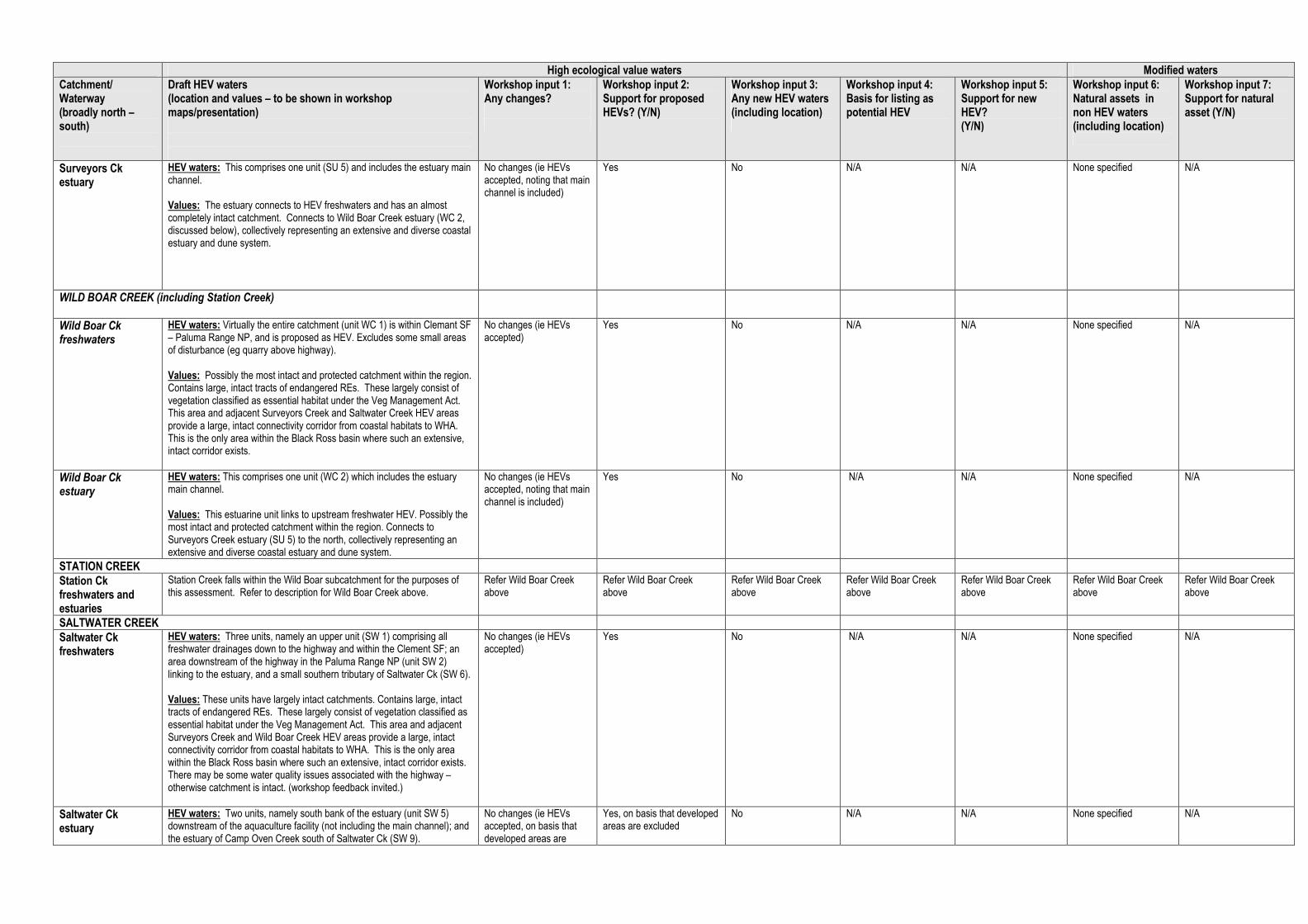
High ecological value waters Modified waters
Catchment/ Waterway (broadly north – south)
Draft HEV waters (location and values – to be shown in workshop maps/presentation)
Workshop input 1: Any changes?
Workshop input 2: Support for proposed HEVs? (Y/N)
Workshop input 3: Any new HEV waters (including location)
Workshop input 4: Basis for listing as potential HEV
Workshop input 5: Support for new HEV? (Y/N)
Workshop input 6: Natural assets in non HEV waters (including location)
Workshop input 7: Support for natural asset (Y/N)
Surveyors Ck estuary
HEV waters: This comprises one unit (SU 5) and includes the estuary main channel. Values: The estuary connects to HEV freshwaters and has an almost completely intact catchment. Connects to Wild Boar Creek estuary (WC 2, discussed below), collectively representing an extensive and diverse coastal estuary and dune system.
No changes (ie HEVs accepted, noting that main channel is included)
Yes No N/A N/A None specified N/A
WILD BOAR CREEK (including Station Creek)
Wild Boar Ck freshwaters
HEV waters: Virtually the entire catchment (unit WC 1) is within Clemant SF – Paluma Range NP, and is proposed as HEV. Excludes some small areas of disturbance (eg quarry above highway). Values: Possibly the most intact and protected catchment within the region. Contains large, intact tracts of endangered REs. These largely consist of vegetation classified as essential habitat under the Veg Management Act. This area and adjacent Surveyors Creek and Saltwater Creek HEV areas provide a large, intact connectivity corridor from coastal habitats to WHA. This is the only area within the Black Ross basin where such an extensive, intact corridor exists.
No changes (ie HEVs accepted)
Yes No N/A N/A None specified N/A
Wild Boar Ck estuary
HEV waters: This comprises one unit (WC 2) which includes the estuary main channel. Values: This estuarine unit links to upstream freshwater HEV. Possibly the most intact and protected catchment within the region. Connects to Surveyors Creek estuary (SU 5) to the north, collectively representing an extensive and diverse coastal estuary and dune system.
No changes (ie HEVs accepted, noting that main channel is included)
Yes No N/A N/A None specified N/A
STATION CREEK
Station Ck freshwaters and estuaries
Station Creek falls within the Wild Boar subcatchment for the purposes of this assessment. Refer to description for Wild Boar Creek above.
Refer Wild Boar Creek above
Refer Wild Boar Creek above
Refer Wild Boar Creek above
Refer Wild Boar Creek above
Refer Wild Boar Creek above
Refer Wild Boar Creek above
Refer Wild Boar Creek above
SALTWATER CREEK
Saltwater Ck freshwaters
HEV waters: Three units, namely an upper unit (SW 1) comprising all freshwater drainages down to the highway and within the Clement SF; an area downstream of the highway in the Paluma Range NP (unit SW 2) linking to the estuary, and a small southern tributary of Saltwater Ck (SW 6). Values: These units have largely intact catchments. Contains large, intact tracts of endangered REs. These largely consist of vegetation classified as essential habitat under the Veg Management Act. This area and adjacent Surveyors Creek and Wild Boar Creek HEV areas provide a large, intact connectivity corridor from coastal habitats to WHA. This is the only area within the Black Ross basin where such an extensive, intact corridor exists. There may be some water quality issues associated with the highway – otherwise catchment is intact. (workshop feedback invited.)
No changes (ie HEVs accepted)
Yes No N/A N/A None specified N/A
Saltwater Ck estuary
HEV waters: Two units, namely south bank of the estuary (unit SW 5) downstream of the aquaculture facility (not including the main channel); and the estuary of Camp Oven Creek south of Saltwater Ck (SW 9).
No changes (ie HEVs accepted, on basis that developed areas are
Yes, on basis that developed areas are excluded
No N/A N/A None specified N/A

High ecological value waters Modified waters
Catchment/ Waterway (broadly north – south)
Draft HEV waters (location and values – to be shown in workshop maps/presentation)
Workshop input 1: Any changes?
Workshop input 2: Support for proposed HEVs? (Y/N)
Workshop input 3: Any new HEV waters (including location)
Workshop input 4: Basis for listing as potential HEV
Workshop input 5: Support for new HEV? (Y/N)
Workshop input 6: Natural assets in non HEV waters (including location)
Workshop input 7: Support for natural asset (Y/N)
Values: Links to upstream HEV waters. Unit SW 5 has connectivity to Camp Oven Ck (SW 9), which has a largely intact catchment largely within Paluma Range NP connecting to Clemant SF upstream. These estuarine wetlands create a largely continuous and diverse coastal wetlands system.
excluded)
LEICHHARDT CREEK
Leichhardt Ck freshwaters
HEV waters: Four units largely within protected estate, including: upper Leichhardt (unit LE 1), largely within the WHA; unit LE 2 extending down to the highway in Clemant SF which includes the riparian area of the stream channel; and at the downstream end, riverine wetlands and other freshwaters (unit LE 3, 4) extending from the highway to the estuary, mainly within Paluma Range NP. Values: Upper reaches are in minimally disturbed catchments. Mid reaches retain good riparian vegetation. The three HEV areas contain large areas of Endangered and Of Concern REs. Leichhardt Creek largely inaccessible by the public and the stream channel and riparian is largely in a natural state along most its entire length. The technical panel recognised this stream for a diverse freshwater fish fauna and the condition of its estuary area.
Generally, no changes (ie HEVs accepted). Need to review location and effects of low artificial barrier (30cm) approx 300m downstream of highway. (Review undertaken � weir approx 150m downstream of highway is already excluded from HEV waters.)
Yes, subject to barrier review.
No N/A N/A None specified N/A
Leichhardt Ck estuary
HEV waters: A single unit (LE 6) which includes the main channel, estuarine waters to the north and south. Links to upstream HEV freshwaters. Values: Links to HEV freshwaters in minimally disturbed catchment. The technical panel determined that the instream habitats, riparian and estuary of Leichhardt Creek are largely intact and in a natural state providing rich fish habitat. Connectivity between upper freshwaters and estuary is evidenced by large numbers of species such as Jungle Perch.
No changes (ie HEVs accepted).
Yes No N/A N/A None specified N/A
SLEEPER LOG CREEK
Sleeper Log Ck freshwaters (includes Two Mile and Christmas Cks)
HEV waters: Two main units, including upper catchment headwaters of Christmas Ck and Sleeper Log Ck (SL1), largely within WHA (SL1); and reaches of Christmas Ck and Sleeper Log Ck (SL 12). Values: Upper catchment units (SL 1) in protected estate/WHA are in minimally disturbed catchments. Lower unit (SL 12) contains large areas of Endangered and Of Concern REs. These areas were identified as HEV waters by the technical panel.
No changes (ie HEVs accepted).
Yes No N/A N/A None specified N/A
Sleeper Log Ck estuary
HEV waters: A single unit (SL 7) that excludes the main channel of Sleeper Log Creek Values: The technical panel identified this area as a large intact estuarine and dune system in a largely natural state connecting to adjacent northern systems.
No changes (ie HEVs accepted).
Yes No N/A N/A None specified N/A
BLUEWATER CREEK
Bluewater Ck freshwaters
HEV waters: One unit (BW 1) comprising upper catchment waters including areas of Mount Cataract SF and State land. Values: This unit is in protected estate and SF in minimally disturbed catchment. Includes large areas of endangered and Of Concern REs and vegetation classified under the Veg Management Act as essential habitat.
No changes (ie HEVs accepted).
Yes No
N/A N/A Palustrine wetland behind dunes north of Bluewater Creek (behind houses -Toolakea). In good condition with minimal clearing.
Yes
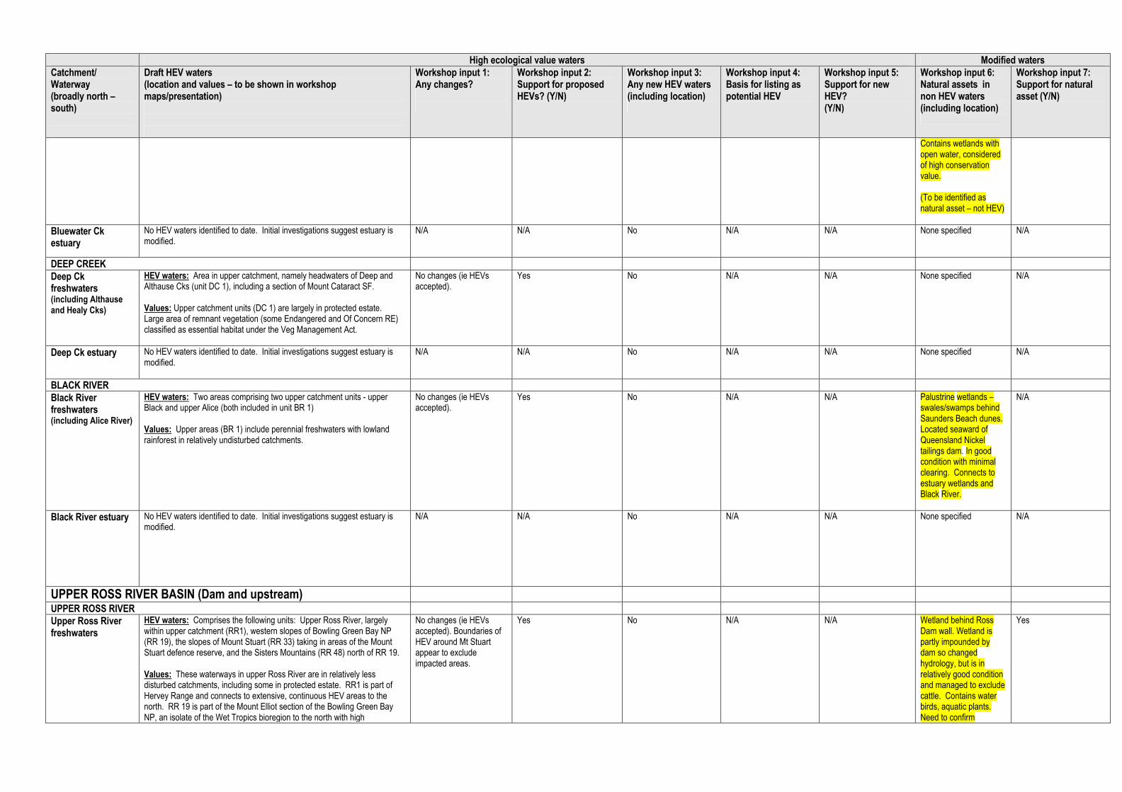
High ecological value waters Modified waters
Catchment/ Waterway (broadly north – south)
Draft HEV waters (location and values – to be shown in workshop maps/presentation)
Workshop input 1: Any changes?
Workshop input 2: Support for proposed HEVs? (Y/N)
Workshop input 3: Any new HEV waters (including location)
Workshop input 4: Basis for listing as potential HEV
Workshop input 5: Support for new HEV? (Y/N)
Workshop input 6: Natural assets in non HEV waters (including location)
Workshop input 7: Support for natural asset (Y/N)
Contains wetlands with open water, considered of high conservation value. (To be identified as natural asset – not HEV)
Bluewater Ck estuary
No HEV waters identified to date. Initial investigations suggest estuary is modified.
N/A N/A No N/A N/A None specified N/A
DEEP CREEK
Deep Ck freshwaters (including Althause and Healy Cks)
HEV waters: Area in upper catchment, namely headwaters of Deep and Althause Cks (unit DC 1), including a section of Mount Cataract SF. Values: Upper catchment units (DC 1) are largely in protected estate. Large area of remnant vegetation (some Endangered and Of Concern RE) classified as essential habitat under the Veg Management Act.
No changes (ie HEVs accepted).
Yes No N/A N/A None specified N/A
Deep Ck estuary
No HEV waters identified to date. Initial investigations suggest estuary is modified.
N/A N/A No N/A N/A None specified N/A
BLACK RIVER
Black River freshwaters (including Alice River)
HEV waters: Two areas comprising two upper catchment units - upper Black and upper Alice (both included in unit BR 1) Values: Upper areas (BR 1) include perennial freshwaters with lowland rainforest in relatively undisturbed catchments.
No changes (ie HEVs accepted).
Yes No N/A N/A Palustrine wetlands – swales/swamps behind Saunders Beach dunes. Located seaward of Queensland Nickel tailings dam. In good condition with minimal clearing. Connects to estuary wetlands and Black River.
N/A
Black River estuary No HEV waters identified to date. Initial investigations suggest estuary is modified.
N/A N/A No N/A N/A None specified N/A
UPPER ROSS RIVER BASIN (Dam and upstream)
UPPER ROSS RIVER
Upper Ross River freshwaters
HEV waters: Comprises the following units: Upper Ross River, largely within upper catchment (RR1), western slopes of Bowling Green Bay NP (RR 19), the slopes of Mount Stuart (RR 33) taking in areas of the Mount Stuart defence reserve, and the Sisters Mountains (RR 48) north of RR 19. Values: These waterways in upper Ross River are in relatively less disturbed catchments, including some in protected estate. RR1 is part of Hervey Range and connects to extensive, continuous HEV areas to the north. RR 19 is part of the Mount Elliot section of the Bowling Green Bay NP, an isolate of the Wet Tropics bioregion to the north with high
No changes (ie HEVs accepted). Boundaries of HEV around Mt Stuart appear to exclude impacted areas.
Yes No N/A N/A Wetland behind Ross Dam wall. Wetland is partly impounded by dam so changed hydrology, but is in relatively good condition and managed to exclude cattle. Contains water birds, aquatic plants. Need to confirm
Yes
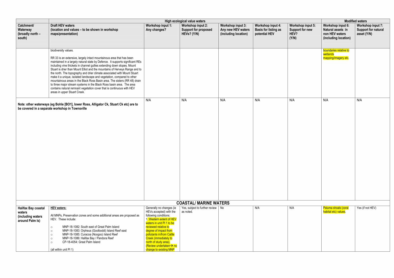
High ecological value waters Modified waters
Catchment/ Waterway (broadly north – south)
Draft HEV waters (location and values – to be shown in workshop maps/presentation)
Workshop input 1: Any changes?
Workshop input 2: Support for proposed HEVs? (Y/N)
Workshop input 3: Any new HEV waters (including location)
Workshop input 4: Basis for listing as potential HEV
Workshop input 5: Support for new HEV? (Y/N)
Workshop input 6: Natural assets in non HEV waters (including location)
Workshop input 7: Support for natural asset (Y/N)
biodiversity values. RR 33 is an extensive, largely intact mountainous area that has been maintained in a largely natural state by Defence. It supports significant REs including vine thickets in channel gullies extending down slopes. Mount Stuart is drier than Mount Elliot and the mountains of Herveys Range and to the north. The topography and drier climate associated with Mount Stuart make it a unique, isolated landscape and vegetation, compared to other mountainous areas in the Black Ross Basin area. The sisters (RR 48) drain to three major stream systems in the Black Ross basin area. The area contains natural remnant vegetation cover that is continuous with HEV areas in upper Stuart Creek.
boundaries relative to wetlands mapping/imagery etc.
Note: other waterways (eg Bohle [BO1], lower Ross, Alligator Ck, Stuart Ck etc) are to be covered in a separate workshop in Townsville
N/A N/A N/A N/A N/A N/A N/A
COASTAL/ MARINE WATERS Halifax Bay coastal waters (including waters around Palm Is)
HEV waters: All MNPs, Preservation zones and some additional areas are proposed as HEV. These include: o MNP-18-1082: South east of Great Palm Island o MNP-18-1083: Orpheus (Goolboddi) Island Reef east o MNP-18-1085: Curacoa (Noogoo) Island Reef o MNP-18-1086: Halifax Bay / Pandora Reef o CP-18-4054: Great Palm Island (all within unit PI 1)
Generally no changes (ie HEVs accepted) with the following conditions: 1. Western extent of HEV waters in unit PI 1 to be reviewed relative to degree of impact from pollutants in/from Cattle Creek (immediately to north of study area). (Review undertaken� no change to existing MNP
Yes, subject to further review as noted.
No N/A N/A Paluma shoals (coral habitat etc) values.
Yes (if not HEV)

High ecological value waters Modified waters
Catchment/ Waterway (broadly north – south)
Draft HEV waters (location and values – to be shown in workshop maps/presentation)
Workshop input 1: Any changes?
Workshop input 2: Support for proposed HEVs? (Y/N)
Workshop input 3: Any new HEV waters (including location)
Workshop input 4: Basis for listing as potential HEV
Workshop input 5: Support for new HEV? (Y/N)
Workshop input 6: Natural assets in non HEV waters (including location)
Workshop input 7: Support for natural asset (Y/N)
Additional waters adjoining the above have also been identified by the technical panel, including Paluma Shoals and waters immediate west of Palm Islands (between MNP-18-1082 and MNP-18-1086) HEV Values: MNP-18-1082:South-east of Great Palm Island B SU H (refer separate code explanation table after this table) The zone includes 3 bioregions (NA3, NB3 and NB5), and includes areas of both Halifax Bay and the Palm Islands special and unique areas, which are of high conservation value owing to their ecological importance and cultural significance. The zone includes shoal areas, important transitory habitat for fishes moving from coastal and inshore nursery grounds to offshore reef and inter-reef habitats. The zone has been placed to exclude Albino, Chilcott, Hayman and Paluma Rocks to the south-east of Great Palm Island as maintenance of access to these rocks for mainly recreational line fishing was raised in submissions on the GBR zoning plan. The potential impact on the recreational line fishery has also been minimised by excluding shoal areas to the south and east of the zone. The zone has also been placed to exclude areas to the east, north-east and west to minimise the potential impact on the trawl fishery. MNP-18-1083: Orpheus (Goolboddi) Island Reef east (18-049d) B NP SU H The zone includes 2 bioregions (NB3 and RHC), and forms part of the Palm Islands special and unique area. The zone builds on a pre-existing MNPZ to simplify the boundary to assist in compliance. The zone complements the adjacent Orpheus Island National Park, its Indigenous cultural heritage values, and protects the fringing reefs on the eastern shore of the island. MNP-18-1085: Curacoa (Noogoo) Island Reef (18-052) B SU H S The zone includes 2 bioregions (NB3 and RHC), and is included in the Palm Islands special and unique area. The zone has been established to protect the fringing reef of Curacoa Island and is limited in placement due to the need to adequately protect the reef bioregion RHC. MNP-18-1086: Halifax Bay / Pandora Reef (18-051) T B CH NP R S The zone includes 2 bioregions (NA3 and RE3), shallow water seagrass beds that provide important foraging habitat for green turtles, and complements the adjacent nationally-significant Herbert River Floodplain, Bambaroo Aggregation Wetlands and the Halifax Bay Wetlands National Park. The zone provides some connectivity between Pandora Reef and inshore habitats, estuaries and wetlands. The zone has been placed to avoid the small reefs and inshore shoals adjacent to and north and south of Crystal Creek to minimise the potential impact on the line and net fisheries. The northern inshore boundary of the zone was revised to reflect submissions on the GBR zoning plan highlighting the importance of area adjacent to Palm Creek for recreational line fishing. The zone is limited in placement due to the need to adequately protect the heavily used non-reef bioregion NA3, however does not extend further east to minimise the
HEV area.) 2. Paluma Shoals HEV area (HB1) to be reviewed, given possible discharges from Cattle Ck and perception from some stakeholders that its coral habitat had been degraded (increased mud re-suspension and effects on benthic substrate ) (Review undertaken – area removed from HEV pending availability of further information to support its inclusion.) Rec from group to speak to Ken Turner (ex comm. fisherman) about his area (not yet done).

High ecological value waters Modified waters
Catchment/ Waterway (broadly north – south)
Draft HEV waters (location and values – to be shown in workshop maps/presentation)
Workshop input 1: Any changes?
Workshop input 2: Support for proposed HEVs? (Y/N)
Workshop input 3: Any new HEV waters (including location)
Workshop input 4: Basis for listing as potential HEV
Workshop input 5: Support for new HEV? (Y/N)
Workshop input 6: Natural assets in non HEV waters (including location)
Workshop input 7: Support for natural asset (Y/N)
potential impact on the trawl fishery and on users of the small islands to the south-west of the Palm Islands Group. CP-18-4054: Great Palm Island B SU R H The zone includes seagrass beds, and has significant cultural and heritage values to the Palm Island Aboriginal community including the traditional use of marine resources. The zone includes Albino, Chilcott, Hayman and Paluma Rocks to the south-east of Palm Island, as submissions identified these rocks as important line fishing areas from Townsville and surrounding communities. Paluma Shoals: This area (HB 1), south west of the Palm Island Group was added by the technical panel based on its values as fish habitat, including mackerel spawning areas. It represents unique benthic shoal reef habitat on sandy alluvial substratum, and occurs on a coastal zone drop off with inter-reef seagrass areas.
Other marine waters (seaward of the above)
All MNPs and Preservation zones are proposed as HEV. Further details on these values are available based on GBRMPA reporting upon request.
No changes (ie HEVs accepted)
Yes No N/A N/A None specified N/A
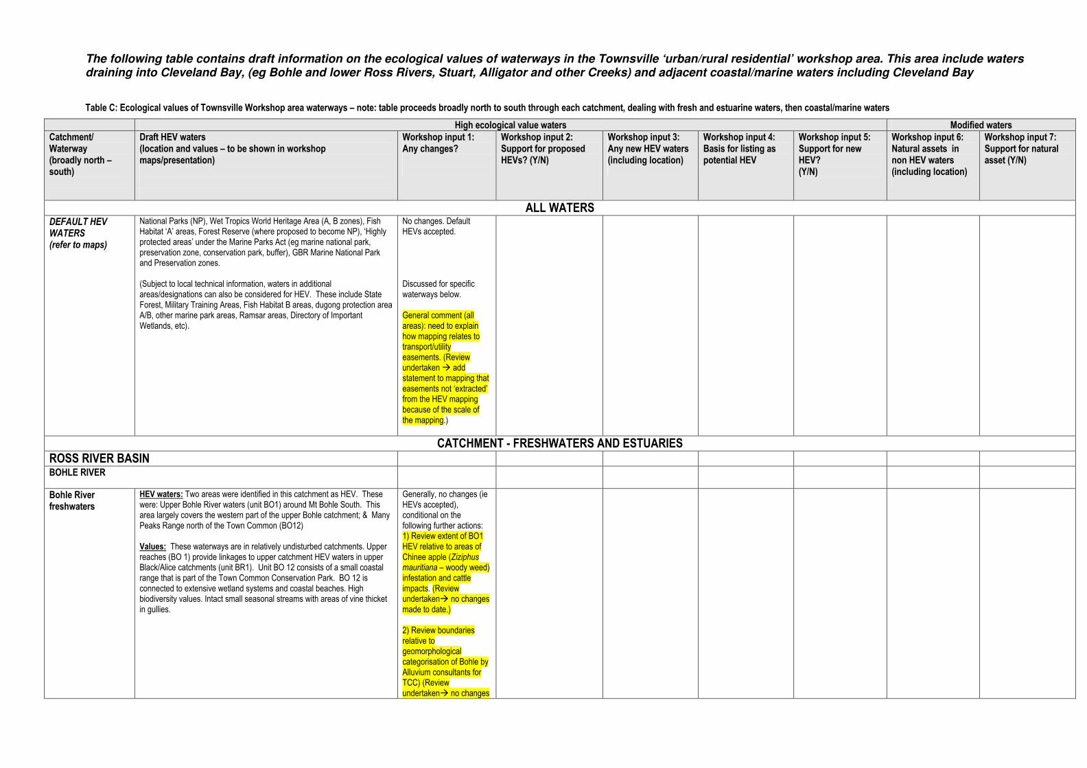
The following table contains draft information on the ecological values of waterways in the Townsville ‘urban/rural residential’ workshop area. This area include waters draining into Cleveland Bay, (eg Bohle and lower Ross Rivers, Stuart, Alligator and other Creeks) and adjacent coastal/marine waters including Cleveland Bay
Table C: Ecological values of Townsville Workshop area waterways – note: table proceeds broadly north to south through each catchment, dealing with fresh and estuarine waters, then coastal/marine waters
High ecological value waters Modified waters
Catchment/ Waterway (broadly north – south)
Draft HEV waters (location and values – to be shown in workshop maps/presentation)
Workshop input 1: Any changes?
Workshop input 2: Support for proposed HEVs? (Y/N)
Workshop input 3: Any new HEV waters (including location)
Workshop input 4: Basis for listing as potential HEV
Workshop input 5: Support for new HEV? (Y/N)
Workshop input 6: Natural assets in non HEV waters (including location)
Workshop input 7: Support for natural asset (Y/N)
ALL WATERS DEFAULT HEV WATERS (refer to maps)
National Parks (NP), Wet Tropics World Heritage Area (A, B zones), Fish Habitat ‘A’ areas, Forest Reserve (where proposed to become NP), ‘Highly protected areas’ under the Marine Parks Act (eg marine national park, preservation zone, conservation park, buffer), GBR Marine National Park and Preservation zones. (Subject to local technical information, waters in additional areas/designations can also be considered for HEV. These include State Forest, Military Training Areas, Fish Habitat B areas, dugong protection area A/B, other marine park areas, Ramsar areas, Directory of Important Wetlands, etc).
No changes. Default HEVs accepted. Discussed for specific waterways below. General comment (all areas): need to explain how mapping relates to transport/utility easements. (Review undertaken � add statement to mapping that easements not ‘extracted’ from the HEV mapping because of the scale of the mapping.)
CATCHMENT - FRESHWATERS AND ESTUARIES
ROSS RIVER BASIN
BOHLE RIVER
Bohle River freshwaters
HEV waters: Two areas were identified in this catchment as HEV. These were: Upper Bohle River waters (unit BO1) around Mt Bohle South. This area largely covers the western part of the upper Bohle catchment; & Many Peaks Range north of the Town Common (BO12) Values: These waterways are in relatively undisturbed catchments. Upper reaches (BO 1) provide linkages to upper catchment HEV waters in upper Black/Alice catchments (unit BR1). Unit BO 12 consists of a small coastal range that is part of the Town Common Conservation Park. BO 12 is connected to extensive wetland systems and coastal beaches. High biodiversity values. Intact small seasonal streams with areas of vine thicket in gullies.
Generally, no changes (ie HEVs accepted), conditional on the following further actions: 1) Review extent of BO1 HEV relative to areas of Chinee apple (Ziziphus mauritiana – woody weed) infestation and cattle impacts. (Review undertaken� no changes made to date.) 2) Review boundaries relative to geomorphological categorisation of Bohle by Alluvium consultants for TCC) (Review undertaken� no changes

High ecological value waters Modified waters
Catchment/ Waterway (broadly north – south)
Draft HEV waters (location and values – to be shown in workshop maps/presentation)
Workshop input 1: Any changes?
Workshop input 2: Support for proposed HEVs? (Y/N)
Workshop input 3: Any new HEV waters (including location)
Workshop input 4: Basis for listing as potential HEV
Workshop input 5: Support for new HEV? (Y/N)
Workshop input 6: Natural assets in non HEV waters (including location)
Workshop input 7: Support for natural asset (Y/N)
made to date.) 3) Check on this area with Merv Hayatt, Burd Council Councillor –local knowledge (to be undertaken)
Bohle River estuary
No HEV waters identified to date. Small area of HEV previously identified in BO12 freshwaters is estuarine and has been re-coded BOE 1 to reflect estuarine waters (overall HEV boundaries unchanged).
N/A N/A Small area of HEV previously identified in BO12 freshwaters is estuarine and has been re-coded BOE 1 to reflect estuarine waters (overall HEV boundaries unchanged).
N/A N/A 1) Shelly Beach area. Limited apparent impacts of plumes from Bohle and Ross rivers. In good condition. 2) Waters at mouth of Bohle have conservation values warranting protection eg seagrass beds, dugong habitat (DPA), despite WQ changes. [Technical panel also recognised values in this area]
Yes.
PALLARENDA
Pallarenda freshwaters
HEV waters: Many Peaks Range (PA 3). Values: Unit PA 3 is part of a small coastal range that is part of the Town Common Conservation Park. PA 3 is connected to extensive wetland systems and coastal beaches. High biodiversity values. Intact small seasonal streams with areas of vine thicket in gullies
No changes (ie HEVs accepted, noting that there are some localised exclusions eg communications infrastructure).
Yes No N/A N/A Saltpan areas in Town Common – relatively unimpacted habitat although changed water quality
Yes – high conservation value
UPPER ROSS RIVER (DAM and UPSTREAM) Note – covered in “rural area” workshop – provided here for context and any comment
Upper Ross River freshwaters
HEV waters: Comprises the following units: Upper Ross River, largely within upper catchment (RR1), western slopes of Bowling Green Bay NP (RR 19) and the slopes of Mount Stuart (RR33) taking in areas of the Mount Stuart defence reserve, and the Sisters Mountains (RR 48) north of RR 19. Values: These waterways in upper Ross River are in relatively less disturbed catchments, including some in protected estate. RR1 is part of Hervey Range and connects to extensive, continuous HEV areas to the north (BO1, BR1). RR19 is part of the Mount Elliot section of the Bowling Green Bay NP, a southern isolate of the Wet Tropics bioregion to the north, with high biodiversity values. RR33 is an extensive, largely intact mountainous area that has been maintained in a largely natural state by Defence. It is drier than Mount Elliot but supports significant REs including vine thickets in channel gullies extending down slopes. Mount Stuart is drier than Mount Elliot and the mountains of Herveys Range and to the north. The topography and drier climate associated with Mount Stuart make it a unique, isolated landscape and vegetation, compared to other mountainous areas in the Black Ross Basin area. The sisters (RR 48) drain to three major stream
No changes (ie HEVs accepted). Attendees considered that boundaries excluded impacted areas (eg weedy areas of Sachs Ck).
Yes No N/A N/A None identified N/A

High ecological value waters Modified waters
Catchment/ Waterway (broadly north – south)
Draft HEV waters (location and values – to be shown in workshop maps/presentation)
Workshop input 1: Any changes?
Workshop input 2: Support for proposed HEVs? (Y/N)
Workshop input 3: Any new HEV waters (including location)
Workshop input 4: Basis for listing as potential HEV
Workshop input 5: Support for new HEV? (Y/N)
Workshop input 6: Natural assets in non HEV waters (including location)
Workshop input 7: Support for natural asset (Y/N)
systems in the Black Ross basin area. The area contains natural remnant vegetation cover that is continuous with HEV areas in upper Stuart Creek.
LOWER ROSS RIVER
Lower Ross River freshwaters
No HEV waters identified to date. N/A N/A No N/A N/A None identified N/A
Ross River estuary
No HEV waters identified to date. N/A N/A No N/A N/A None identified N/A
STUART CREEK
Stuart Ck freshwaters
HEV waters: Upper reach and tributaries of Stuart Creek of the Sisters Mountains down to approximately the 80 m contour (unit ST 1). Values: This area retains natural remnant vegetation cover that is continuous with the HEV areas in the Ross (RR 48) and the Alligator Creek (AL22) catchments. This amalgamation therefore drains to three major stream systems in the Black Ross basin area. Populations of the endangered Black Throated finch have been recorded in the Upper Stuart Creek and Upper Ross catchments. This species relies on the surface water of these areas during dry season. Large perennial spring-fed pools occur in the upper reaches of Stuart Creek. These represent very high value aquatic habitat and surface water during the dry season in an otherwise dry landscape.
HEVs accepted, with need to review the following: 1) Permanent springs in the upper reaches of Stuart Creek - for inclusion. 2) Use of contour line to delineate HEV area. 3) HEV boundaries relative to Rocky Springs development. (Review of above related comments undertaken� HEVs boundary refined to include additional area covering main springs.)
Yes, subject to boundary check
No N/A N/A None identified N/A
Stuart Ck estuary
No HEV waters identified to date. N/A N/A No N/A N/A None specified N/A
ALLIGATOR CREEK
Alligator Ck freshwaters
HEV waters: Upper reaches (within Mt Elliott section of Bowling Green Bay National Park) have been identified as HEV. These comprise waters in upper-most reaches above swimming area/camp ground (unit AL 1), and the swimming area and waters further downstream (unit AL 2) to the NP boundary. Additional areas in Alligator Creek catchment identified as HEV include: AL 18 (within lower section of Cape Bowling Green NP adjacent to estuary between Alligator and Crocodile Creeks), AL 20 (slopes of Mt Cleveland within NP draining into Cocoa Ck), AL 21 (Mt Matthew, north of Bruce Highway), and AL 22 (the Sisters Mountains in the western part of Alligator Ck catchment draining into Slippery Rocks Ck). Values: AL 1 and 2 are within NP catchment at the southern extreme of Wet Tropics type conditions with rainforest headwaters. Unit AL 1 is the more upstream area and is within a largely natural catchment. It contains several endemic species of note, including a Euasticus bindal crayfish. The perennial nature of the stream systems of Mount Elliot (e.g. Alligator Creek, Killymoon Creek) are very important to aquatic species in the area, including
Generally, no changes (ie HEVs accepted) conditional on reviewing the following: 1) Review HEV boundaries (eg Mt Matthew) relative to State Development Area associated with Sun Metals property (check precinct zonings) (Review undertaken: HEVs are in ‘buffer’ area rather than intensive industry� no changes made to date.)
Yes, (subject to boundary check).
No N/A N/A Adjacent freshwater lot (42CP905700) in buffer area connects AL21 freshwater HEV to downstream estuarine HEV AL 15 (see below)
N/A (identified after workshop)

High ecological value waters Modified waters
Catchment/ Waterway (broadly north – south)
Draft HEV waters (location and values – to be shown in workshop maps/presentation)
Workshop input 1: Any changes?
Workshop input 2: Support for proposed HEVs? (Y/N)
Workshop input 3: Any new HEV waters (including location)
Workshop input 4: Basis for listing as potential HEV
Workshop input 5: Support for new HEV? (Y/N)
Workshop input 6: Natural assets in non HEV waters (including location)
Workshop input 7: Support for natural asset (Y/N)
a rich fish fauna. These streams in turn connect to extensive coastal wetlands of the Bowling Green Bay wetland complex. High biodiversity values (both aquatic and terrestrial). Unit AL 2 retains intact riparian habitats and supports high aquatic biodiversity. Its water quality is generally good, receiving flow from relatively undisturbed catchment. Water quality can naturally vary (poorer in dry years) and these conditions can be exacerbated as a result of swimming activities (eg increased faecal coliform concentrations) for a short period. AL 18 is part of Bowling Green Bay NP and is adjacent to other HEV areas (AL 16) AL 20 (slopes of Mt Cleveland) is a small intact catchment adjacent to other HEV areas (MC1, CB 1, AL 16) draining into Cocoa Ck (AL 19). Unit AL 21 (Mt Matthew) contains a large area of intact remnant vegetation that drains to coastal estuaries through seasonal stream systems including Whites Ck. Also identified in technical panel workshop as having values. Unit AL 22 (the Sisters) : This area retains natural remnant vegetation cover that is continuous with the HEV areas in the Ross (RR 48) and Stuart Ck (ST 1) catchments. This amalgamation therefore drains to three major stream systems in the Black Ross basin area. Populations of the endangered Black Throated finch have been recorded in the Upper Stuart Creek and Upper Ross catchments. This species relies on the surface water of these areas during dry season.
Alligator Ck estuary
HEV waters: Estuaries on the north (unit AL 15) and south (AL 16) banks of Alligator Ck are proposed as HEV. This does not include the main channel of Alligator Ck. Also includes Crocodile Ck estuary (AL 17) and Coco Ck estuary (AL 19). Values: Alligator Ck units (AL 15, AL 16): Extensive estuarine habitats which includes three major estuarine creek systems. This area provides important and productive estuarine fisheries habitat and nursery, as well as habitat for a rich bird fauna and saltwater crocodile. These estuaries are also associated with extensive seagrass beds in Cleveland Bay (CL1) which supports populations of Dugong. Crocodile Ck (AL 17): very limited development in catchment. The majority of the catchment is within Bowling Green Bay NP. Cocoa Ck (AL 19): This is an undeveloped catchment within Bowling Green Bay NP.
Yes, several changes recommended to HEV boundaries, mainly in relation to their western extent: 1) AL 15: reduce extent of HEVs on western side of estuary (ie on Cleveland Palms side) due to disturbance, weeds etc. Option to use the river as the boundary of HEVs. (HEV on east side of river was supported). (Review undertaken�. No changes made to date – current boundaries appear to exclude developed areas) 2) AL 16 – review freehold lots between Alligator and Crocodile Cks for possible HEVs. (Review undertaken� undisturbed lots included
Conditional on further review of boundaries
No N/A N/A None specified N/A
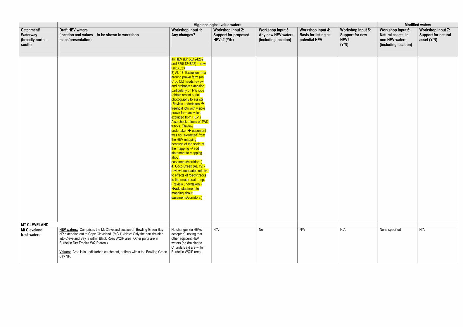
High ecological value waters Modified waters
Catchment/ Waterway (broadly north – south)
Draft HEV waters (location and values – to be shown in workshop maps/presentation)
Workshop input 1: Any changes?
Workshop input 2: Support for proposed HEVs? (Y/N)
Workshop input 3: Any new HEV waters (including location)
Workshop input 4: Basis for listing as potential HEV
Workshop input 5: Support for new HEV? (Y/N)
Workshop input 6: Natural assets in non HEV waters (including location)
Workshop input 7: Support for natural asset (Y/N)
as HEV (LP 5E124282 and 320k124822) = new unit AL23 3) AL 17: Exclusion area around prawn farm (on Croc Ck) needs review and probably extension, particularly on NW side (obtain recent aerial photography to assist) (Review undertaken � freehold lots with visible prawn farm activities excluded from HEV.) Also check effects of 4WD tracks. (Review undertaken� easement was not ‘extracted’ from the HEV mapping because of the scale of the mapping �add statement to mapping about easements/corridors.) 4) Coco Creek (AL 19) - review boundaries relative to effects of roads/tracks to the (mud) boat ramp. (Review undertaken - �add statement to mapping about easements/corridors.)
MT CLEVELAND
Mt Cleveland freshwaters
HEV waters: Comprises the Mt Cleveland section of Bowling Green Bay NP extending out to Cape Cleveland (MC 1) (Note: Only the part draining into Cleveland Bay is within Black Ross WQIP area. Other parts are in Burdekin Dry Tropics WQIP area.). Values: Area is in undisturbed catchment, entirely within the Bowling Green Bay NP.
No changes (ie HEVs accepted), noting that other adjacent HEV waters (eg draining to Chunda Bay) are within Burdekin WQIP area.
N/A No N/A N/A None specified N/A
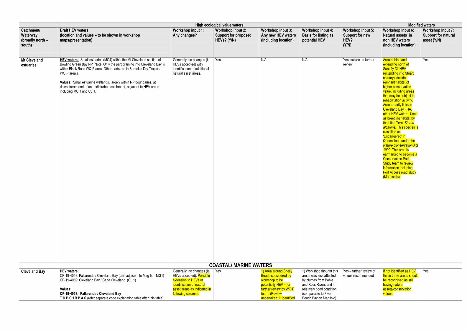
High ecological value waters Modified waters
Catchment/ Waterway (broadly north – south)
Draft HEV waters (location and values – to be shown in workshop maps/presentation)
Workshop input 1: Any changes?
Workshop input 2: Support for proposed HEVs? (Y/N)
Workshop input 3: Any new HEV waters (including location)
Workshop input 4: Basis for listing as potential HEV
Workshop input 5: Support for new HEV? (Y/N)
Workshop input 6: Natural assets in non HEV waters (including location)
Workshop input 7: Support for natural asset (Y/N)
Mt Cleveland estuaries
HEV waters: Small estuaries (MC4) within the Mt Cleveland section of Bowling Green Bay NP (Note: Only the part draining into Cleveland Bay is within Black Ross WQIP area. Other parts are in Burdekin Dry Tropics WQIP area.). Values: Small estuarine wetlands, largely within NP boundaries, at downstream end of an undisturbed catchment, adjacent to HEV areas including MC 1 and CL 1.
Generally, no changes (ie HEVs accepted) with identification of additional natural asset areas.
Yes. N/A N/A Yes, subject to further review
Area behind and extending north of Sandfly Ck HEV (extending into Stuart estuary) includes remnant habitat of higher conservation value, including areas that may be subject to rehabilitation activity. Area broadly links to Cleveland Bay FHA, other HEV waters. Used as breeding habitat by the Little Tern, Sterna albifrons. This species is classified as ‘Endangered’ in Queensland under the Nature Conservation Act 1992. This area is earmarked to become a Conservation Park. Study team to review information including Port Access road study (Maunsells).
Yes
COASTAL/ MARINE WATERS Cleveland Bay HEV waters:
CP-19-4058: Pallarenda / Cleveland Bay (part adjacent to Mag Is – MG1) CP-19-4059: Cleveland Bay / Cape Cleveland (CL 1) Values: CP-19-4058: Pallarenda / Cleveland Bay T D B CH R P A S (refer separate code explanation table after this table)
Generally, no changes (ie HEVs accepted). Possible extension to HEVs or identification of natural asset areas as indicated in following columns.
Yes 1) Area around Shelly Beach considered by workshop to be potentially HEV – for further review by WQIP team. (Review undertaken� identified
1) Workshop thought this areas was less affected by plumes from Bohle and Ross Rivers and in relatively good condition (comparable to Five Beach Bay on Mag Isld)
Yes – further review of values recommended
If not identified as HEV these three areas should be recognised as still having natural assets/conservation values.
Yes.

High ecological value waters Modified waters
Catchment/ Waterway (broadly north – south)
Draft HEV waters (location and values – to be shown in workshop maps/presentation)
Workshop input 1: Any changes?
Workshop input 2: Support for proposed HEVs? (Y/N)
Workshop input 3: Any new HEV waters (including location)
Workshop input 4: Basis for listing as potential HEV
Workshop input 5: Support for new HEV? (Y/N)
Workshop input 6: Natural assets in non HEV waters (including location)
Workshop input 7: Support for natural asset (Y/N)
(only the part adjacent to Mag Is is identified as HEV). The zone builds substantially on a pre-existing CPZ at Pallarenda and extends the zone to Magnetic Island, protecting seagrass beds and significant dugong and green turtle foraging habitat. The zone includes fringing reefs on the western shore of Magnetic Island, as well as Middle Reef and Virago Shoal. The zone complements the adjacent Townsville Town Common Conservation Park, the Cape Pallarenda Conservation Park, the Magnetic Island National Park, and the Cleveland Bay – Magnetic Island DPA ‘A’ Zone. The zone does not extend further east to minimise the potential impact on the trawl fishery. The area is particularly important for recreational use from Townsville and its surrounds. CP-19-4059: Cleveland Bay / Cape Cleveland T D B CH NP H P A S The zone expands on a pre-existing CPZ on the eastern shore of Cape Cleveland to include the entire eastern shore south to the SRZ adjacent to the Australian Institute of Marine Science (SR-19-2008), and much of the western shore and eastern Cleveland Bay. The zone includes parts of both the Cleveland Bay and Bowling Green Bay DPA ‘A’ and ‘B’ Zones respectively, and includes some of the most substantial seagrass beds in the region, which are important habitats for dugong, green turtles, juvenile fish and crustaceans. In addition, it is adjacent to Bowling Green Bay National Park and the nationally significant Burdekin-Townsville Coastal Aggregation Wetlands. The zone includes many areas important for the line fishery, including the Cleveland Bay seagrass beds, Cape Cleveland and Salamander Reef. The zone gives protection to this area whilst allowing for limited fishing. The zone does not extend further west to minimise the potential impact on the trawl fishery.
as natural asset - refer separate column) 2) Review West Channel (between mainland and Mag Isld) as possible HEV. (with any localised exclusion areas if required). (Review undertaken � natural asset) 3) Review Middle Reef as possible HEV or natural asset (Review undertaken � natural asset, given some WQ issues based on WQ data)
(Review undertaken � natural asset) 2) WQ comparable to Shelly Beach and resuspension due to shallow nature of channel. 3) Mixture of inshore and reef species providing a high diversity.
Additionally, waters at mouth of Bohle have conservation values warranting protection eg seagrass beds, dugong habitat (DPA), despite WQ changes.
Halifax Bay coastal waters (including waters around Palm Is) – separate workshop
HEV waters: All MNPs, Preservation zones and some additional areas are proposed as HEV. These include: o MNP-18-1082: South east of Great Palm Island o MNP-18-1083: Orpheus (Goolboddi) Island Reef east o MNP-18-1085: Curacoa (Noogoo) Island Reef o MNP-18-1086: Halifax Bay / Pandora Reef o CP-18-4054: Great Palm Island (all captured under PI 1) Additional waters adjoining the above have also been identified by the technical panel, including Paluma Shoals and waters immediate west of Palm Islands (between MNP-18-1082 and MNP-18-1086) HEV Values: MNP-18-1082:South-east of Great Palm Island B SU H (refer separate code explanation table after this table) The zone includes 3 bioregions (NA3, NB3 and NB5), and includes areas of both Halifax Bay and the Palm Islands special and unique areas, which are
Generally, no changes (ie HEVs accepted). Possible extension to HEVs as indicated in following columns.
Yes Workshop recommended review of waters around Acheron Isld and waters around Rattlesnake Isld (subject to use for defence purposes). Probably not appropriate to include Cordelia Rocks SE of Acheron Isld (Review undertaken� not identified as HEV but do have natural asset values)
Good WQ and other conservation values. Study team to obtain and review defence report. (Review undertaken� not identified as HEV but do have natural asset values)
Subject to review Yes. Waters around Acheron, Rattlesnake Islds
Yes

High ecological value waters Modified waters
Catchment/ Waterway (broadly north – south)
Draft HEV waters (location and values – to be shown in workshop maps/presentation)
Workshop input 1: Any changes?
Workshop input 2: Support for proposed HEVs? (Y/N)
Workshop input 3: Any new HEV waters (including location)
Workshop input 4: Basis for listing as potential HEV
Workshop input 5: Support for new HEV? (Y/N)
Workshop input 6: Natural assets in non HEV waters (including location)
Workshop input 7: Support for natural asset (Y/N)
of high conservation value owing to their ecological importance and cultural significance. The zone includes shoal areas, important transitory habitat for fishes moving from coastal and inshore nursery grounds to offshore reef and inter-reef habitats. The zone has been placed to exclude Albino, Chilcott, Hayman and Paluma Rocks to the south-east of Great Palm Island as maintenance of access to these rocks for mainly recreational line fishing was raised in submissions on the GBR zoning plan. The potential impact on the recreational line fishery has also been minimised by excluding shoal areas to the south and east of the zone. The zone has also been placed to exclude areas to the east, north-east and west to minimise the potential impact on the trawl fishery. MNP-18-1083: Orpheus (Goolboddi) Island Reef east (18-049d) B NP SU H The zone includes 2 bioregions (NB3 and RHC), and forms part of the Palm Islands special and unique area. The zone builds on a pre-existing MNPZ to simplify the boundary to assist in compliance. The zone complements the adjacent Orpheus Island National Park, its Indigenous cultural heritage values, and protects the fringing reefs on the eastern shore of the island. MNP-18-1085: Curacoa (Noogoo) Island Reef (18-052) B SU H S The zone includes 2 bioregions (NB3 and RHC), and is included in the Palm Islands special and unique area. The zone has been established to protect the fringing reef of Curacoa Island and is limited in placement due to the need to adequately protect the reef bioregion RHC. MNP-18-1086: Halifax Bay / Pandora Reef (18-051) T B CH NP R S The zone includes 2 bioregions (NA3 and RE3), shallow water seagrass beds that provide important foraging habitat for green turtles, and complements the adjacent nationally-significant Herbert River Floodplain, Bambaroo Aggregation Wetlands and the Halifax Bay Wetlands National Park. The zone provides some connectivity between Pandora Reef and inshore habitats, estuaries and wetlands. The zone has been placed to avoid the small reefs and inshore shoals adjacent to and north and south of Crystal Creek to minimise the potential impact on the line and net fisheries. The northern inshore boundary of the zone was revised to reflect submissions on the GBR zoning plan highlighting the importance of area adjacent to Palm Creek for recreational line fishing. The zone is limited in placement due to the need to adequately protect the heavily used non-reef bioregion NA3, however does not extend further east to minimise the potential impact on the trawl fishery and on users of the small islands to the south-west of the Palm Islands Group. CP-18-4054: Great Palm Island B SU R H The zone includes seagrass beds, and has significant cultural and heritage values to the Palm Island Aboriginal community including the traditional use of marine resources. The zone includes Albino, Chilcott, Hayman and Paluma Rocks to the south-east of Palm Island, as submissions on the GBR zoning plan identified these rocks as important line fishing areas from Townsville and surrounding communities.

High ecological value waters Modified waters
Catchment/ Waterway (broadly north – south)
Draft HEV waters (location and values – to be shown in workshop maps/presentation)
Workshop input 1: Any changes?
Workshop input 2: Support for proposed HEVs? (Y/N)
Workshop input 3: Any new HEV waters (including location)
Workshop input 4: Basis for listing as potential HEV
Workshop input 5: Support for new HEV? (Y/N)
Workshop input 6: Natural assets in non HEV waters (including location)
Workshop input 7: Support for natural asset (Y/N)
Paluma Shoals: This area (HB 1), south west of the Palm Island Group was added by the technical panel based on its values as fish habitat, including mackerel spawning areas. It represents unique benthic shoal reef habitat on sandy alluvial substratum, and occurs on a coastal zone drop off with inter-reef seagrass areas
Magnetic Island (separate workshop)
HEV waters: All fringing coastal waters around Magnetic Island (MG 1), aside from Nelly Bay Harbour, are proposed as HEV waters. These comprise a number of Marine National Parks (MNPs), Conservation Parks (CPs), and some additional waters based on technical panel advice. Key MNPs included as HEV waters are: o MNP-19-1089 Magnetic Island - Five Beach Bay o MNP-19-1090 Magnetic Island - Balding Bay & Radical Bay o MNP-19-1091 Magnetic Island - Gowrie Bay o MNP-19-1092 Magnetic Island - Florence Bay o MNP-19-1093 Magnetic Island - Alma Bay o MNP-19-1094 Magnetic Island - Geoffrey Bay Key CPs included as HEV waters are: o CP-19-4057 Mag Is-Arthur Bay o CP-19-4058 Pallarenda – Cleveland Bay (part - adjacent Mag Is) Additionally, the HEV waters include waters under Dugong Protection Area (Rollingstone Bay - north west side of Island), and seagrass meadows on the south side of the Island (partly within Conservation Park), and some habitat protection areas (based on technical panel advice). Values: MNPs: T D B NP S TS (refer separate code explanation table after this table)
These zones include 2 bioregions (NA3 and RE3) and afford protection to several bays adjacent to Magnetic Island National Park and within the Cleveland Bay – Magnetic Island DPA ‘A’ Zone important for dugongs and is an important green turtle foraging habitat. The zone in Five Beach Bay (MNP-19-1089) builds on a pre-existing MNPZ simplifying the boundary to assist in compliance and protecting the fringing coral reef within the Bay. White Rock, which was identified as an important line fishing location through submissions on the GBR zoning plan, has not been included in the zone. MNP-19-1090 builds on a pre-existing MNPZ at Balding Bay to include Radical Bay, which was previously a CPZ. Gowrie Bay (MNP-19-1091), Florence Bay (MNP-19-1092) and Alma Bay (MNP-19-1093) have been zoned MNPZ to afford greater protection to the well-developed fringing reefs. MNP-19-1094 reflects the previous MNPZ at Geoffrey Bay. The zone recognises these bays for their non-extractive tourism and recreational values. The boundaries of these zones have been configured to minimise the potential impact on the recreational line fishery by allowing these activities to continue on most of the headlands adjacent to the bays, raised as important through submissions on the GBR zoning plan.
Refer to comments on Cleveland Bay above. Otherwise, no additional comments made.
Refer Cleveland Bay comments above
Refer Cleveland Bay comments above
Refer Cleveland Bay comments above
Refer Cleveland Bay comments above
Refer Cleveland Bay comments above
Refer Cleveland Bay comments above

High ecological value waters Modified waters
Catchment/ Waterway (broadly north – south)
Draft HEV waters (location and values – to be shown in workshop maps/presentation)
Workshop input 1: Any changes?
Workshop input 2: Support for proposed HEVs? (Y/N)
Workshop input 3: Any new HEV waters (including location)
Workshop input 4: Basis for listing as potential HEV
Workshop input 5: Support for new HEV? (Y/N)
Workshop input 6: Natural assets in non HEV waters (including location)
Workshop input 7: Support for natural asset (Y/N)
2) CPs CP-19-4057:Magnetic Island - Arthur Bay T B NP TS The zone recognises the conservation values of Arthur Bay whilst also recognising its importance to local residents and visitors as a location for limited line fishing and spearfishing. The zone complements the adjacent Magnetic Island National Park, the Cleveland Bay – Magnetic Island DPA ‘A’ Zone, protects the fringing reefs and important green turtle foraging habitat.
CP-19-4058:Pallarenda / Cleveland Bay T D B CH R P A S The zone builds substantially on a pre-existing CPZ at Pallarenda and extends the zone to Magnetic Island, protecting seagrass beds and significant dugong and green turtle foraging habitat. The zone includes fringing reefs on the western shore of Magnetic Island, as well as Middle Reef and Virago Shoal. The zone complements the adjacent Townsville Town Common Conservation Park, the Cape Pallarenda Conservation Park, the Magnetic Island National Park, and the Cleveland Bay – Magnetic Island DPA ‘A’ Zone. The zone does not extend further east to minimise the potential impact on the trawl fishery. The area is particularly important for recreational use from Townsville and its surrounds. (only the part adjacent to Mag Is is identified as HEV).
Other marine waters (seaward of the above)
All MNPs and Preservation zones are proposed as HEV. Further details on these values are available based on GBRMPA reporting upon request.
No changes (ie HEVs accepted).
Yes No N/A N/A None specified N/A
![Lecture 5: Values and Objectives - ml.zmml.uni-bremen.de · Episode 2: Case Study American Apparel [Sustainability Marketing – A Global Perspective] ... Values and Objectives •](https://static.fdocuments.in/doc/165x107/5e1c3693e9a37a73920f9fee/lecture-5-values-and-objectives-mlzmmluni-episode-2-case-study-american-apparel.jpg)


![NGTSM 2015 Goals, Objectives and Targets [F1] · PDF fileGoals, Objectives and Targets [F1] Transport and Infrastructure Council | 2015 National Guidelines for Transport System Management](https://static.fdocuments.in/doc/165x107/5a9e168e7f8b9ad2298d202c/ngtsm-2015-goals-objectives-and-targets-f1-objectives-and-targets-f1-transport.jpg)