Environmental Impact Statement: Lee Point Master- planned ...
244
MELBOURNE: 292 Mt Alexander Road, Ascot Vale VIC 3032 GEELONG: 230 Latrobe Terrace, Geelong West Vic 3218 BRISBANE: Level 22, 127 Creek Street, Brisbane QLD 4000 ADELAIDE: 22 Greenhill Road, Wayville SA 5034 CANBERRA: PO Box 6067, O’Connor ACT 2602 SYDNEY: Level 5, 616 Harris Street, Ultimo, NSW, 2007 www.ehpartners.com.au | (03) 9377 0100 Draft Report Environmental Impact Statement: Lee Point Master- planned Urban Development Prepared for Defence Housing Australia October 2017 Ecology and Heritage Partners Pty Ltd
Transcript of Environmental Impact Statement: Lee Point Master- planned ...

MELBOURNE: 292 Mt Alexander Road, Ascot Vale VIC 3032 GEELONG: 230 Latrobe Terrace, Geelong West Vic 3218 BRISBANE: Level 22, 127 Creek Street, Brisbane QLD 4000 ADELAIDE: 22 Greenhill Road, Wayville SA 5034
CANBERRA: PO Box 6067, O’Connor ACT 2602 SYDNEY: Level 5, 616 Harris Street, Ultimo, NSW, 2007 www.ehpartners.com.au | (03) 9377 0100
Draft Report
Environmental Impact Statement: Lee Point Master-
planned Urban Development
Prepared for
Defence Housing Australia
October 2017
Ecology and Heritage Partners Pty Ltd

Lee Point Master-planned Urban Development – Environmental Impact Statement 2
DOCUMENT CONTROL
Assessment Environmental Impact Statement
Address Lee Point Master-planned Urban Development
Project number 7793
Project manager Dr Thomas Wright (Senior Ecologist)
Report reviewer Aaron Organ (Principal Ecologist/Director)
Other EHP staff Janice Taylor (Consultant Ecologist); Jordan Whitmore (Botanist)
File name EHP_7793_EISLeePointMPUD_30102017
Client Defence Housing Australia
Report versions Comments Comments updated by Date submitted
Draft v 1 internal review
Minor grammatical changes TW 21/05/2017
Draft v 2 submitted to DHA (2CRU only)
Changes to project details TW 22/05/2017
Draft v 3 submitted to DHA (2CRU and Muirhead North)
Updated project plan TW 21/07/2017
Draft v 4 internal review
Minor grammatical changes TW 28/07/2017
Draft v 5 submitted to DoEE and NT EPA
Submitted to DoEE and NT EPA TW, AO 31/07/2017
Draft v 6 submitted to DoEE and NT EPA
Updated to address DoEE comments TW 13/10/2017
Draft v 7 submitted to DoEE and NT EPA
Updated to address DoEE comments re migratory shorebird monitoring
TW 30/10/2017
Copyright © Ecology and Heritage Partners Pty Ltd This document is subject to copyright and may only be used for the purposes for which it was commissioned. The use or copying of this document in whole or part without the permission of Ecology and Heritage Partners Pty Ltd is an infringement of copyright.
Disclaimer
Although Ecology and Heritage Partners Pty Ltd have taken all the necessary steps to ensure that an accurate document has been prepared, the company accepts no liability for any damages or loss incurred as a result of reliance placed upon the report and its contents.

Lee Point Master-planned Urban Development – Environmental Impact Statement 3
ACRONYMS AND ABBREVIATIONS
2CRU 2 Control and Reporting Unit
AAPA Aboriginal Areas Protection Authority
ABS Australian Bureau of Statistics
AHD Australian Height Datum
BOM Bureau of Meteorology
C Commercial (Planning Zone)
CBD Central Business District
CDU Charles Darwin University
CEMP Construction Environment Management Plan
CN Conservation (Planning Zone)
CP Community Purpose (Planning Zone)
CV Caravan Park (Planning Zone)
DCA Development Consent Authority (Darwin Division)
Defence Department of Defence
DENR NT Department of Environment and Natural Resources
DHA Defence Housing Australia
DIPL Northern Territory Department of Infrastructure, Planning and Logistics
DoEE Commonwealth Department of the Environment and Energy
DoS Degree of Saturation
DoT Department of Transport
DRLUP Darwin Regional Land Use Plan
EA Act Northern Territory Environment Assessment Act 1982
EIS Environmental Impact Statement
EP Equivalent Persons
EPA Northern Territory Environment Protection Authority
EPANGDS Environment Protection Authority’s Noise Guidelines for Development Sites in the Northern Territory
EPBC Act Commonwealth Environment Protection and Biodiversity Conservation Act 1999
ESCP Erosion and Sediment Control Plan
ESC Ecological Sustainable Development
FD Future Development (Planning Zone)
GDE Groundwater Dependent Ecosystem
GP Gross Pollutants
ha Hectare
HR High Density Residential (Planning Zone)
km Kilometre

Lee Point Master-planned Urban Development – Environmental Impact Statement 4
KPI Key Performance Indicator
LOS Level of Service
m Metre
MD Multiple Dwelling (Planning Zone)
MDR Medium Density Residential (Planning Zone)
MSDS Material Safety Data Sheet
MUSIC Model for Urban Stormwater Improvement Conceptualisation
NAFI Northern Australia Fire Information
NES National Enviornmental Significance
NRET NT Natural Resources, Environment and the Arts
NT Northern Territory
OR Organised Recreation (Planning Zone)
PER Public Environment Report
PMST Protected Matters Search Tool
The Project Lee Point Master-planned Urban Development
Project footprint
Areas that could potentially be impacted by the project, i.e. 2CRU, Muirhead North, Sandy Creek, Buffalo Creek and Casuarina Beach.
Project site 2CRU (Lot 04873) and Muirhead North (Lot 09370)
PS Public Open Space (Planning Zone)
PWC Northern Territory Power and Water Corporation
SD Special Use Darwin (Planning Zone)
SPS Sewer Pump Station
TC Tourist Commercial (Planning Zone)
TIA Traffic Impact Assessment
TN Total Nitrogen
ToR Terms of Reference
TP Total Phosphorous
TPWC Act NT Territory Parks and Wildlife Conservation Act
TSS Total Suspended Solids
UDIA Urban Development Institute of Australia
WQO Water Quality Objective
WM Act NT Weed Management Act 2001
WoNS Weed of National Significance
WSUD Water Sensitive Urban Design

Lee Point Master-planned Urban Development – Environmental Impact Statement 5
CONTENTS
1 INTRODUCTION . . . . . . . . . . . . . . . . . . . . . . . . . . . . . . . . . . . . . . . . . . . . . . . . . . . . . . . . . . . . . . . . . . . . . . . . . . . . . . . . . . . . . . . . . . . . . . . . . . . 8
1.1 Background ........................................................................................................................................ 8
1.2 Purpose .............................................................................................................................................. 9
1.3 Structure ............................................................................................................................................ 9
1.4 Defence Housing Australia (the proponent) .................................................................................... 11
2 PROJECT DESCRIPTION . . . . . . . . . . . . . . . . . . . . . . . . . . . . . . . . . . . . . . . . . . . . . . . . . . . . . . . . . . . . . . . . . . . . . . . . . . . . . . . . . . . . . . . . 13
2.1 General Information ........................................................................................................................ 13
2.2 Project Site ....................................................................................................................................... 13
2.3 Climate ............................................................................................................................................. 15
2.4 Project Description .......................................................................................................................... 17
3 RISK ASSESSMENT . . . . . . . . . . . . . . . . . . . . . . . . . . . . . . . . . . . . . . . . . . . . . . . . . . . . . . . . . . . . . . . . . . . . . . . . . . . . . . . . . . . . . . . . . . . . . . 21
3.1 Introduction ..................................................................................................................................... 21
3.2 Method ............................................................................................................................................ 21
3.3 Results .............................................................................................................................................. 21
4 HYDROLOGY . . . . . . . . . . . . . . . . . . . . . . . . . . . . . . . . . . . . . . . . . . . . . . . . . . . . . . . . . . . . . . . . . . . . . . . . . . . . . . . . . . . . . . . . . . . . . . . . . . . . . . 27
4.1 Introduction ..................................................................................................................................... 27
4.2 Existing Conditions ........................................................................................................................... 28
4.3 Risk Assessment ............................................................................................................................... 39
5 AIR QUALITY . . . . . . . . . . . . . . . . . . . . . . . . . . . . . . . . . . . . . . . . . . . . . . . . . . . . . . . . . . . . . . . . . . . . . . . . . . . . . . . . . . . . . . . . . . . . . . . . . . . . . . 52
5.1 Introduction ..................................................................................................................................... 52
5.2 Existing Conditions ........................................................................................................................... 53
5.3 Risk Assessment ............................................................................................................................... 55
6 UTILITIES AND INFRASTRUCTURE . . . . . . . . . . . . . . . . . . . . . . . . . . . . . . . . . . . . . . . . . . . . . . . . . . . . . . . . . . . . . . . . . . . . . . . . . . 58
6.1 Introduction ..................................................................................................................................... 58
6.2 Existing Conditions and Impacts ...................................................................................................... 58
6.3 Risk Assessment ............................................................................................................................... 71
7 BIODIVERSITY AND HERITAGE . . . . . . . . . . . . . . . . . . . . . . . . . . . . . . . . . . . . . . . . . . . . . . . . . . . . . . . . . . . . . . . . . . . . . . . . . . . . . . 75
7.1 Introduction ..................................................................................................................................... 75
7.2 Existing Conditions ........................................................................................................................... 76
7.3 Risk Assessment ............................................................................................................................. 137
7.4 Significant Impact Assessment ....................................................................................................... 145
7.5 Environmental Offsets ................................................................................................................... 158
8 SOCIAL ECONOMIC . . . . . . . . . . . . . . . . . . . . . . . . . . . . . . . . . . . . . . . . . . . . . . . . . . . . . . . . . . . . . . . . . . . . . . . . . . . . . . . . . . . . . . . . . . . 162

Lee Point Master-planned Urban Development – Environmental Impact Statement 6
8.1 Introduction ................................................................................................................................... 162
8.2 Legislation ...................................................................................................................................... 163
8.3 Locality ........................................................................................................................................... 164
8.4 Lee Point Master Planned Urban Development ............................................................................. 166
8.5 Existing Conditions and Project Impact .......................................................................................... 172
8.6 Risk Assessment ............................................................................................................................. 193
9 NOISE . . . . . . . . . . . . . . . . . . . . . . . . . . . . . . . . . . . . . . . . . . . . . . . . . . . . . . . . . . . . . . . . . . . . . . . . . . . . . . . . . . . . . . . . . . . . . . . . . . . . . . . . . . . . . 206
9.1 Introduction ................................................................................................................................... 206
9.2 Existing conditions and impacts ..................................................................................................... 207
9.3 Risk Assessment ............................................................................................................................. 216
10 CONCLUSION . . . . . . . . . . . . . . . . . . . . . . . . . . . . . . . . . . . . . . . . . . . . . . . . . . . . . . . . . . . . . . . . . . . . . . . . . . . . . . . . . . . . . . . . . . . . . . . . 220
11 REFERENCES . . . . . . . . . . . . . . . . . . . . . . . . . . . . . . . . . . . . . . . . . . . . . . . . . . . . . . . . . . . . . . . . . . . . . . . . . . . . . . . . . . . . . . . . . . . . . . . . . 221
APPENDIX A. . . . . . . . . . . . . . . . . . . . . . . . . . . . . . . . . . . . . . . . . . . . . . . . . . . . . . . . . . . . . . . . . . . . . . . . . . . . . . . . . . . . . . . . . . . . . . . . . . . . . . . . . . . 228
Terms of Reference .................................................................................................................................... 228
APPENDIX B . . . . . . . . . . . . . . . . . . . . . . . . . . . . . . . . . . . . . . . . . . . . . . . . . . . . . . . . . . . . . . . . . . . . . . . . . . . . . . . . . . . . . . . . . . . . . . . . . . . . . . . . . . . 230
Contributors ............................................................................................................................................... 230
APPENDIX C . . . . . . . . . . . . . . . . . . . . . . . . . . . . . . . . . . . . . . . . . . . . . . . . . . . . . . . . . . . . . . . . . . . . . . . . . . . . . . . . . . . . . . . . . . . . . . . . . . . . . . . . . . . 231
Risk Assessment ......................................................................................................................................... 231
APPENDIX D . . . . . . . . . . . . . . . . . . . . . . . . . . . . . . . . . . . . . . . . . . . . . . . . . . . . . . . . . . . . . . . . . . . . . . . . . . . . . . . . . . . . . . . . . . . . . . . . . . . . . . . . . . 232
Construction Environmental Management Plan ........................................................................................ 232
APPENDIX E . . . . . . . . . . . . . . . . . . . . . . . . . . . . . . . . . . . . . . . . . . . . . . . . . . . . . . . . . . . . . . . . . . . . . . . . . . . . . . . . . . . . . . . . . . . . . . . . . . . . . . . . . . . 233
Stormwater Management Plan – 2CRU ..................................................................................................... 233
APPENDIX F . . . . . . . . . . . . . . . . . . . . . . . . . . . . . . . . . . . . . . . . . . . . . . . . . . . . . . . . . . . . . . . . . . . . . . . . . . . . . . . . . . . . . . . . . . . . . . . . . . . . . . . . . . . 234
Stormwater Management Plan – Muirhead North .................................................................................... 234
APPENDIX G . . . . . . . . . . . . . . . . . . . . . . . . . . . . . . . . . . . . . . . . . . . . . . . . . . . . . . . . . . . . . . . . . . . . . . . . . . . . . . . . . . . . . . . . . . . . . . . . . . . . . . . . . . 235
Biting Insect report .................................................................................................................................... 235
APPENDIX H . . . . . . . . . . . . . . . . . . . . . . . . . . . . . . . . . . . . . . . . . . . . . . . . . . . . . . . . . . . . . . . . . . . . . . . . . . . . . . . . . . . . . . . . . . . . . . . . . . . . . . . . . . 236
Noise Impact Assessment report – 2CRU ................................................................................................... 236
APPENDIX I . . . . . . . . . . . . . . . . . . . . . . . . . . . . . . . . . . . . . . . . . . . . . . . . . . . . . . . . . . . . . . . . . . . . . . . . . . . . . . . . . . . . . . . . . . . . . . . . . . . . . . . . . . . 238
Noise Impact Assessment report – Muirhead North ................................................................................. 238
APPENDIX J . . . . . . . . . . . . . . . . . . . . . . . . . . . . . . . . . . . . . . . . . . . . . . . . . . . . . . . . . . . . . . . . . . . . . . . . . . . . . . . . . . . . . . . . . . . . . . . . . . . . . . . . . . . 239
Odour Impact Assessment report .............................................................................................................. 239
APPENDIX K . . . . . . . . . . . . . . . . . . . . . . . . . . . . . . . . . . . . . . . . . . . . . . . . . . . . . . . . . . . . . . . . . . . . . . . . . . . . . . . . . . . . . . . . . . . . . . . . . . . . . . . . . . . 240
Traffic Impact Assessment report - 2CRU .............................................................................................. 240

Lee Point Master-planned Urban Development – Environmental Impact Statement 7
APPENDIX L . . . . . . . . . . . . . . . . . . . . . . . . . . . . . . . . . . . . . . . . . . . . . . . . . . . . . . . . . . . . . . . . . . . . . . . . . . . . . . . . . . . . . . . . . . . . . . . . . . . . . . . . . . . 241
Traffic Impact Assessment report – Muirhead North ................................................................................ 241
APPENDIX M . . . . . . . . . . . . . . . . . . . . . . . . . . . . . . . . . . . . . . . . . . . . . . . . . . . . . . . . . . . . . . . . . . . . . . . . . . . . . . . . . . . . . . . . . . . . . . . . . . . . . . . . . . 242
Black-footed Tree-rat report ...................................................................................................................... 242
APPENDIX N . . . . . . . . . . . . . . . . . . . . . . . . . . . . . . . . . . . . . . . . . . . . . . . . . . . . . . . . . . . . . . . . . . . . . . . . . . . . . . . . . . . . . . . . . . . . . . . . . . . . . . . . . . 243
Migratory Shorebird report ....................................................................................................................... 243
APPENDIX O . . . . . . . . . . . . . . . . . . . . . . . . . . . . . . . . . . . . . . . . . . . . . . . . . . . . . . . . . . . . . . . . . . . . . . . . . . . . . . . . . . . . . . . . . . . . . . . . . . . . . . . . . . 244
Water Quality Monitoring Plan .................................................................................................................. 244

Lee Point Master-planned Urban Development – Environmental Impact Statement 8
1 INTRODUCTION
1.1 Background
Defence Housing Australia (DHA) is proposing the Lee Point Master-planned Urban Development (the
project) which will establish a residential, tourism, community and commercial precinct on a 132.5 hectare
(ha) site (the project site) located on the outskirts of Darwin, in the suburb of Nightcliff. The project site
consists of two properties bisected by Lee Point Road, including a former Department of Defence (Defence)
installation that was operated by the 2 Control and Reporting Unit (2CRU) on the western side of Lee Point
Road (referred to as the 2CRU site), and vacant crown land on the east side of Lee Point Road (referred to as
Muirhead North) The project will provide for residential lots at a range of densities, providing much needed
affordable housing for Defence families and for members of the public. The project will involve a Main Street
precinct that will include a tourism activity centre containing restaurants, cafes, hotels, self-contained
apartments and retail shops which will capitalise on its close proximity to Lee Point and the Casuarina
Coastal Reserve, Darwin’s most popular area of public open space. The project will also deliver serviced
allotments to the NT Government that will be dedicated to a primary school, child-care centre and sporting
oval.
The project will generate much needed economic stimulus for the Darwin region which is suffering declining
growth as a result of the downturn in the mining, and oil and gas industries. It is estimated that the project
will contribute $350 million to the local economy, and provide full-time employment for up to 964
employees in the construction industry, 117 full-time and part-time employees in the hospitality industry
and 40 full-time employees in education. There will also be a focus on employing and training indigenous
people.
Environmental impacts were considered during the planning phase, and the project was referred under the
Commonwealth Environment Protection and Biodiversity Conservation Act 1999 (EPBC 2015/7591). It was
assessed on 18 December 2015 as a controlled action due to likely impacts on listed threatened and
migratory species and as a Commonwealth action, and would be further assessed by Public Environment
Report (PER). The project was also assessed under the Northern Territory Environmental Assessment Act
1982 (EA Act) and the preparation of an Environmental Impact Statement (EIS) was requested on 18 January
2016 by the Northern Territory Environment Protection Authority (EPA) to assess the impacts of the project
on threatened species, erosion, the Casuarina Coastal Reserve and biting insects.
While the bilateral assessment agreement between the Northern Territory and Australian Governments does
not take effect in this instance, the NT EPA and Australian Government have coordinated the preparation of
a combined Terms of Reference (ToR) which address both Commonwealth and Northern Territory
assessment requirements. A draft ToR for the project was released for public comment on 23 April 2016 and
finalised on 20 May 2016. A copy of the final ToR is provided in Appendix A.

Lee Point Master-planned Urban Development – Environmental Impact Statement 9
1.2 Purpose
The EIS for the Lee Point Master-planned Urban Development (2CRU) has been prepared to address the ToR
and thereby satisfy approval conditions under the EPBC Act and EA Act. The ToR broadly requires further
information on the follow matters:
The existing environmental conditions of the project footprint
Infrastructure requirements to service the local community
Assessment of impacts and risks to the environment, economy and local community
Management measures to mitigate or avoid the likely impacts of the project.
Specialist consultants were engaged to undertake detailed engineering, environmental and social-economic
studies and prepare reports that specifically address the ToR. The reports are included as appendices to the
EIS. Information has also been drawn from previous assessments that were undertaken to support the initial
EPBC Act referral and Notice of Intent lodgement.
To identify the key risks to the environment, community, economy and existing infrastructure, a detailed risk
assessment was undertaken using international best practice standards (Australian and New Zealand Risk
Management Standard AS/NZS ISO 3100:2009). This process informed the project activities that would
require avoidance and mitigation measures to ensure impacts remained within regulatory requirements and
where possible, community’s expectations. The avoidance and mitigation measures proposed are detailed in
a Construction and Environmental Management Plan (CEMP) that will be implemented during the
construction phase of the project. The CEMP is supported by a number of sub-plans that relate to each
environmental discipline that the CEMP addresses.
1.3 Structure
The EIS has been structured in a logical manner to reflect the information requested as part of the ToR, and
to facilitate a range of different readers (e.g. referral agencies, utility companies, environmental groups and
members of the community) to easily locate information in the EIS that is relevant to them. A detailed
project description is provided in Chapter 0. The main technical chapters covering hydrology, air quality,
utilities and infrastructure, biodiversity and heritage, social and economic and noise, can be found in
Chapters 4 to 9 respectively. Each of these chapters is structured in the following manner:
1. Existing conditions
2. Project impacts
3. Risk assessment
4. Avoidance and mitigation measures.
Detailed technical reports supporting the findings and recommendations in the main body of the EIS are
provided in Appendix E to Appendix O. The detailed risk assessment results are provided in Appendix C and
summarised in each technical chapter, while Chapter 3 provides a description of how the risk assessment
was applied. As requested by the NT EPA and DoEE, the final copy of the ToR is included in Appendix A and a

Lee Point Master-planned Urban Development – Environmental Impact Statement 10
list of contributors that assisted with the preparation of the EIS including the technical studies and risk
assessments is provided in Appendix B.
Table 1. EIS Structure
Chapter No. Title Scope
1 Introduction Introduction to the project, justification for preparing the EIS and basic information on the proponent.
2 Project Description Describes in detail all aspects of the project including site history, development stages and timelines.
3 Risk Assessment Methodology for completing the risk assessment
4 Hydrology Technical chapter addressing existing surface water and groundwater conditions and proposed stormwater management plan.
5 Air Quality Technical chapter addressing noise and odour impacts.
6 Utilities and Infrastructure Technical chapter addressing potable water, sewerage, traffic, power and telecommunications.
7 Biodiversity and Heritage Technical chapter addressing impacts to threatened species, migratory shorebirds land condition, and cultural and historic heritage.
8 Social Economic Technical chapter addressing the social and economic impacts (positive and negative) of the project.
9 Noise Technical chapter addressing the potential noise and vibration impacts associated with the project.
9 Conclusion Summarises the key impacts of the project and how they will be addressed.
10 References List of references cited in the EIS.
Appendix A Terms of Reference Copy of the final ToR and tabulated response to how each criteria in the ToR has been addressed.
Appendix B Contributors List of people who contributed to the preparation of the EIS
Appendix C Risk Assessment Detailed results of the Risk Assessment
Appendix D CEMP Construction Environmental Management Plan with sub-plans
Appendix E Stormwater Management Plan – 2CRU
Technical document supporting Chapter 4
Appendix F Stormwater Management Plan – Muirhead North
Technical document supporting Chapter 4
Appendix G Biting Insect Report Technical document supporting Chapter 4 and general design of Area Plan.
Appendix H Noise Impact Assessment report – 2CRU
Technical document supporting Chapter 5
Appendix I Noise Impact Assessment report – Muirhead North
Technical document supporting Chapter 5
Appendix J Odour Impact Assessment report
Technical document supporting Chapter 5
Appendix K Traffic Impact Assessment report – 2CRU
Technical document supporting Chapter 6
Appendix L Traffic Impact Assessment report – Muirhead North
Technical document supporting Chapter 6

Lee Point Master-planned Urban Development – Environmental Impact Statement 11
Chapter No. Title Scope
Appendix M Black-footed Tree-rat Report Technical document supporting Chapter 7
Appendix N Migratory Shorebird report Technical document supporting Chapter 7
Appendix O Water Quality Monitoring Plan Monitoring plan to assess impact of the development on adjoining waterways.
1.4 Defence Housing Australia (the proponent)
Defence Housing Australia is a Commonwealth Government business responsible for providing housing and
related services for Department of Defence members and their families. This includes providing an active
role in the residential housing market by acquiring and developing land, and constructing and purchasing
houses. They have undertaken a number of projects that have been referred and approved under the EPBC
Act , including:
North Weston Residential Development, ACT (EPBC# 2011/6163)
Muirhead Subdivision, Northern Territory (EPBC# 2010/5525)
RM Military College Duntroon, ACT (EPBC# 2001/374)
Stirling – Weston Creek, ACT (EPBC# 2001/218)
Darwin Residential Complex NT (EPBC# 2001/163).
In addition to the Lee Point Master-planned Urban Development, the Rawlings Road Deebing Heights project
in Queensland (EPBC# 2016/7723) is currently being assessed under the EPBC Act.
Defence Housing Australia has shown to be an environmentally responsible organisation by complying with
environmental approval and regulatory conditions for all their projects. They also show a commitment to the
principles of Ecological Sustainable Development (ESD), as demonstrated at the Muirhead Breezes
residential development which adjoins the Muirhead North site to the south. Muirhead Breezes has
orientated lots to align with the prevailing breeze (hence the name ‘Muirhead Breezes’), and focussed on a
climatically-responsive small lot housing, which has resulted in a corresponding reduction in energy
consumption. This innovative approach to environmentally sensitive housing has been recognised with the
following industry awards:
2016 Urban Development Institute of Australia (UDIA) Northern Territory Award for Environmental
Excellence
2016 UDIA Northern Territory Awards for Innovation in Design
2015 UDIA Northern Territory Award for Excellence in Masterplanned Development
2015 UDIA Northern Territory Award for Excellence for Environmentally Sustainable Development.
This approach to ESD has been carried through to the Lee Point Master-planned Urban Development.

Lee Point Master-planned Urban Development – Environmental Impact Statement 12
Table 2. Proponents details
Title Lee Point Master-planned Urban Development
Location 544 (Lot 9370) and 577 (Lot 4873) Lee Point Road, Nightcliff, Northern Territory
Proponent
Defence Housing Australia
1 Carey Street, Darwin, Northern Territory
T 08 8901 7107
Contact: Chris Grimm

Lee Point Master-planned Urban Development – Environmental Impact Statement 13
2 PROJECT DESCRIPTION
2.1 General Information
Defence Housing Australia (DHA) is proposing the Lee Point Master-planned Urban Development to provide
housing, a tourism precinct, community infrastructure and public open space on a 132.5 ha site located at
544 and 577 Lee Point Road, Nightcliff, North Territory. The project site is located approximately 14
kilometres (km) north-north-east of the Darwin Central Business District (CBD) and covers Lot 4873 (2CRU)
and Lot 9370 (Muirhead North).
The project site is bisected by Lee Point Road with 2CRU located on the western side of Lee Point Road and
Muirhead north on the eastern side. It is adjoined to the south of 2CRU by the Lyons residential
development and by the Muirhead Breezes residential development to the south of Muirhead North. The
Casuarina Coastal Reserve including Sandy Creek border the western boundary of 2CRU and the reserve
extends to the northern boundary of 2CRU. Casuarina Coastal Reserve is Darwin’s most popular public area
of natural public open space and provides recreation facilities and public amenity including walking and
mountain-bike trails (formal and informal), a surf-life saving club, military history, car-parking, toilets and
access to the Casuarina Beach. Sandy Creek enters the Beagle Gulf through Casuarina Coastal Reserve and
receives run-off from the western half of the 2CRU site.
The Lee Point Village Resort fronts onto the northern boundary of Muirhead North. Buffalo Creek is located
to the east of Muirhead North and receives run-off from Muirhead North and the eastern half of 2CRU
through culverts which drain into Muirhead North. Buffalo Creek flows into Shoal Bay and is considered to be
the most polluted tributed discharging into Darwin Harbour.
2.2 Project Site
The project site is zoned Future Development (FD) under the City of Darwin Planning Scheme (Figure 1).
The 2CRU site is located at Lot 04873 Town of Nightcliff, 577 Lee Point Road and was owned by the
Commonwealth Department of Defence (Defence) until recently, when ownership transferred to DHA. The
project site was used by Defence as a communication facility and was operated by 2CRU between 1959 and
2002. During this period it had an important role in the Malayan Emergency and also supported Australia’s
involvement in the Konfrontasi conflict. The project site was inactive between 1974 and 1981 as a result of
the considerable damage caused by Cyclone Tracy. The site was purchased by DHA in May 2014. Since then
the site has remained vacant; however, there are ongoing issues with illegal site access for motorbike riding
and dumping of household and industrial waste. There is also a historical problem with gully erosion in the
south-west of the project site that is contributing sediment to the nearby Sandy Creek and providing habitat
for biting insects.

Lee Point Master-planned Urban Development – Environmental Impact Statement 14
Most of the communication facilities installed by Defence have been removed from the project site, except
for a cruciform anti-battery site located in the centre of the site, and an area to the north referred as ‘The
Bunkers’ which contains remnants of missile foundations, a concrete bunker and explosives/ammunitions
store. Most of the project site is covered by introduced grassland, or degraded bushland that has
regenerated since Defence operations ceased, although the western boundary of the site is covered in
mature Monsoon Vine-thicket.
There is a formal vehicle track from Lee Point Road into the middle of the site where a compound was once
situated, with other less formal tracks, including from the former compound heading in a southerly direction,
ultimately running adjacent to the southern site boundary and connecting with the trails in the Casuarina
Coastal Reserve. Vehicle tracks and firebreaks are present along the eastern and southern property
boundaries. There are numerous informal vehicle tracks within the site, along with evidence of itinerant
camps. Fencing along the road frontage has been repeatedly vandalised to allow illegal access.
The adjoining Muirhead North site is located at Lot 09370 Town of Nightcliff, 544 Lee Point Road, on the
eastern side of Lee Point Road. It is identified as vacant crown land, and with the exception of the
telecommunications tower and associated equipment shelter, is void of built form. The site is covered with
remnant vegetation, with natural and modified drainage paths occurring across the site to the Leanyer
Swamp further east. There is some seasonal inundation in the very eastern extent of the site, although the
majority of the site consists of well-drained soils. There are numerous informal vehicle tracks within the site,
and evidence of recreational four-wheel drive and/or motorcycle/quad bike access.
Muirhead North gently slopes towards the east with small localised undulations located throughout the
property. The eastern portion of 2CRU is similar, with a ridge line extending north-south in close parallel to
Lee Point Road. The western portion of 2CRU falls sharply from an escarpment, with vegetation below the
escarpment comprising Monsoon Vine-thicket that continues into the coastal reserve.
Figure 1. Planning zones

Lee Point Master-planned Urban Development – Environmental Impact Statement 15
2.3 Climate
The project site experiences a tropical savannah climate, with a dry season extending from May to
September and a wet season running from October to March. During the dry season, mean monthly rainfall
varies between 1.1 millimetres (mm) in July and 21.6 mm in May and mean monthly relative humidity is
below 50% and as low as 37% in July (see Figure 2). At the beginning of the wet season, mean monthly
relative humidity continually rises until peaking in February at 72%. This pattern is broadly consistent with
the mean monthly rainfall pattern which is also unimodal and peaks at 423.7 mm in January (see Figure 3).
Monsoon conditions prevail from December to March when the mean monthly rainfall exceeds 250 mm and
most days during this period receive rain.
Mean monthly maximum temperatures are warmest in the wet season and coolest in the dry season, but
vary little between months ranging between 30.6 °C in July and 33.3 °C in October and November (Figure 2).
The onset of monsoons results in a small but noticeable decrease in mean maximum temperatures between
December and March. There is a larger variation in mean minimum temperatures which range between 19.3
°C in July and 25.3 °C in November and December.
Figure 2. Temperate and relative humidity data (Bureau of Meteorology Darwin Airport)
35
40
45
50
55
60
65
70
75
19
21
23
25
27
29
31
33
35
Re
lati
ve H
um
idit
y %
Tem
pe
ratu
re (
°C)
Maximum Temperature
Minimum Temperature
Relative Humidty

Lee Point Master-planned Urban Development – Environmental Impact Statement 16
Figure 3. Rainfall data (Bureau of Meteorology Darwin Airport)
0
3
6
9
12
15
18
21
24
27
0
50
100
150
200
250
300
350
400
450
No
. of
Rai
ny
Day
s
Rai
nfa
ll (m
m)
Rainfall
Rainy Days

Lee Point Master-planned Urban Development – Environmental Impact Statement 17
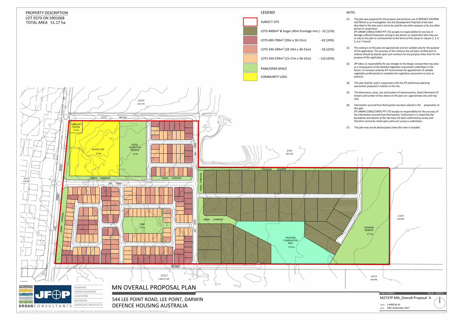
2.4 Project Description
The Lee Point Master-planned Urban Development will be developed in accordance with the Lee Point Area
Plan and Planning Principle’s as described in DHA’s application to amend the NT Planning Scheme
(PA2014/0922). It will accommodate approximately 700 ground-level dwellings, between 30 and 40 rural
residential lots, and between 200 and 250 apartments (see masterplan and site plans overleaf).
The Lee Point Area Plan identifies a tourism and mixed use centre situated along a Main Street precinct in
2CRU running from Lee Point Road through the site in a north-westerly direction where it will terminate at a
coastal esplanade. The area will provide most of the high density residence in 3-6 storey apartments. The
coastal esplanade runs perpendicular to the Main Street precinct and parallel to the Casuarina Coastal
Reserve. It will be an important area of public open space and provide bicycle and walking paths and other
recreation facilities. There will also be a small area of open space in the north of the site as part of the
preservation of local military history.
The Main Street precinct will provide a mixture of commercial, retail and community services. There are also
four tourist sites to be established along the Main Street that will be transferred to the NT Government and
will provide for hotel and apartment accommodation in buildings between 2-12 stories.
A Community Hub will be located in Muirhead North, and will include a primary school, child-care facility and
sports facilities, covering approximately 3.7 ha. Immediately adjacent to the Community Hub will be an
active recreation reserve including an AFL/cricket oval.
In addition to the coastal esplanade in 2CRU, other areas of public open space will include the preservation
of 21.95 ha of Monsoon Vine-thicket and eucalypt woodland on the western side of 2CRU to conserve
habitat for the endangered Black-footed Tree-rat and expand the area of the existing Casuarina Coastal
Reserve. A further 1.6 ha within Muirhead North supporting sensitive Monsoon Rainforest vegetation will be
protected. The treatment train of bioretention and detention basins to manage stormwater will be
integrated into public open space, contributing an additional 10 ha (approximate). A series of parks and
playground areas will be set-aside across the project site.
The current staging plan for the projects proposes a seven staged development, with commencement of civil
works scheduled to commence in May 2018 (Table 3). Buildings and other facilities will be established once
civil construction works are completed.
Table 3. Staging plan for Lee Point Master-planned Urban Development (dates are subject to change)
Stage Estimated Start Date Estimated Completion Date
1A May 2018 December 2018
1B April 2019 November 2019
2A March 2020 December 2020
2B March 2021 November 2021
3 March 2022 October 2022
4 April 2023 November 2023
5 March 2024 November 2024

COPYRIGHT 2017 JFP URBAN CONSULTANTS PTY LTD. THIS DOCUMENT MAY NOT BE COPIED OR TRANSMITTED IN ANY FORM OR BY ANY MEANS IN PART OR IN WHOLE WITHOUT THE WRITTEN CONSENT OF JFP URBAN CONSULTANTS PTY LTD.
OVERALL PROPOSAL PLAN
SCALE:
DATE:
JOB NUMBER: NORTH:N
LEE POINT ROAD, LEE POINT, DARWINDEFENCE HOUSING AUSTRALIA
M2737P_Overall Proposal E
1:5000 @ A313th September 2017
PLANNERSURBAN DESIGNERS
SURVEYORS
ENGINEERSLANDSCAPE ARCHITECTS
PROPERTY DESCRIPTIONLOT 4873 ON S78/107TOTAL AREA 81.33 ha
ISSUE:
SUBJECT SITE
LEGEND
MIXED USE RESIDENTIAL (1.39 ha)
LOCAL CENTRE (0.51 ha)
PARK/OPEN SPACE
MEDIUM DENSITY RESIDENTIAL (1.57 ha)
CONSERVATION AREA
TOURISM PRECINCT (2.78 ha)
BIO-DETENTION BASIN
WWII HERITAGE AREA
PROPOSED MOUNTAIN BIKE TRAIL
ACCESS TO BEACH
COPYRIGHT 2017 JFP URBAN CONSULTANTS PTY LTD. THIS DOCUMENT MAY NOT BE COPIED OR TRANSMITTED IN ANY FORM OR BY ANY MEANS IN PART OR IN WHOLE WITHOUT THE WRITTEN CONSENT OF JFP URBAN CONSULTANTS PTY LTD.
MN OVERALL PROPOSAL PLAN
SCALE:
DATE:
JOB NUMBER: NORTH:N
544 LEE POINT ROAD, LEE POINT, DARWINDEFENCE HOUSING AUSTRALIA
M2737P MN_Overall Proposal A
1:4000 @ A329th September 2017
PLANNERSURBAN DESIGNERS
SURVEYORS
ENGINEERSLANDSCAPE ARCHITECTS
PROPERTY DESCRIPTIONLOT 9370 ON S901068TOTAL AREA 51.17 ha
ISSUE:
SUBJECT SITE
LEGEND
PARK/OPEN SPACE
COMMUNITY USES


Lee Point Master-planned Urban Development – Environmental Impact Statement 21
3 RISK ASSESSMENT
3.1 Introduction
A comprehensive risk assessment of all potential project impacts has been undertaken in accordance with
Australian and New Zealand Risk Management Standard AS/NZS ISO 3100:2009. The risk assessment
provides a systematic process to quantify the severity of impact to the environment, community and local
infrastructure the project is likely to cause, and identifies which project activities will require management
controls or avoidance measures to ensure that any impact does not exceed regulatory thresholds and meets
the public’s expectations (where possible). The risk assessment was undertaken in the following manner:
1. Identify the risks to the environment
2. Identify the likely causes for risks to occur
3. Establish likelihood and consequence descriptors
4. Establish outcome descriptors
5. Quantify risk
6. Determine appropriate controls to reduce risk level to an acceptable level.
3.2 Method
The risk assessment was completed by specialist consultants responsible for preparing the detailed technical
reports (Appendix B). After determining the potential risks to the environment, and what factors contribute
to the risk, the risk level was quantified by determining the outcome, where outcome is calculated as:
- Outcome = Likelihood x Consequence
The tables below provide descriptions for the different levels of likelihood, consequence and outcome.
A description of the project activities that may contribute to impacts and were considered during the risk
assessment is provided in Table 7.
3.3 Results
The detailed results of the risk assessment, including the recommended mitigation and avoidance measures
are provided in Appendix C, and further explained in each relevant technical chapter of the EIS. A total of 98
risks were identified that have been assigned a management control.

Lee Point Master-planned Urban Development – Environmental Impact Statement 22
Table 4. Consequence rating descriptors
Consequence Hydrology Air Quality Utilities and Infrastructure Biodiversity Heritage Social Noise
Minimal Negligible effect to the environment
Impacts to air quality below detectable levels.
No discernible impact on quality of service.
Small scale native vegetation or habitat loss.
Low-level repairable damage to commonplace structures.
Some people indirectly impacted.
Noise can barely be detected.
Minor
Minor effect, complaint from adjacent neighbours or community. Temporary impact on subterranean conditions, aquifer or Sandy Creek without long-lasting effects. Temporary disruption to water supply or effect on water quality.
Impact on local air quality is within allowable limits, no discernible impacts on health.
Available services cannot meet the need of local residents.
Small to medium scale native vegetation/habitat loss. Fragmentation of habitat for native species.
Minor damage to items of low cultural heritage significance. Mostly repairable. Minor infringement of cultural heritage values.
Some people directly impacted or several indirectly.
Noise detected, low-level of nuisance
Moderate
Localised impact, local media coverage, may trigger regulators involvement. Short term impact on sensitive environmental features, aquifer resource or Sandy Creek.
Temporary impact on local air quality exceeds allowable limit,, impact on respiratory health, loss of native vegetation.
Additional demand results in decline in service quality for wider community.
Potential significant impact on special/ecological communities, medium to large scale native vegetation loss/habitat fragment for native species.
Substantial damage to items of moderate cultural or heritage significance. Infringement of cultural heritage/sacred locations.
Several people directly impacted or many indirectly.
Temporary sleep disturbance, potential hearing injury, complaints from adjoining residents..
Major Major impact, national media coverage, would
Damage to respiratory health
Additional demand results in health impacts for residents and wider community. Local/regional media
Significant impact on species/ecological communities
Major permanent damage to
Large number of people
Temporary hearing loss, ongoing sleep

Lee Point Master-planned Urban Development – Environmental Impact Statement 23
Consequence Hydrology Air Quality Utilities and Infrastructure Biodiversity Heritage Social Noise
trigger regulators involvement.
requiring specialist medical treatment, local-regional media coverage, significant remediation works required.
attention. items of high cultural or heritage significance. Significant infringement and disregard of cultural heritage values.
directly impacted.
disturbance, damage to buildings and structures, local/reigional media attention.
Catastrophic
Extensive off-site contamination and changes to level of groundwater, or quality of Sandy Creek. Sustained damage to the environment/human health and remediation not possible. National to international media coverage, regulators involved.
Permanent damage to respiratory health, national media coverage, irrevocable damage to regional air quality.
Additional demand results in deaths in local community. National media attention.
Extinction of species/ecological communities
Total destruction of items of high cultural or heritage significance. Highly offensive infringements of cultural heritage.
Loss of life.
Permanent hearing loss, damage to buildings. National media attention.

Lee Point Master-planned Urban Development – Environmental Impact Statement 24
Table 5. Likelihood rating descriptors.
Likelihood Description Probability Community attitude
Remote May occur in exceptional circumstances <1% Few people interested
Unlikely Not expected to occur in most circumstances 1-20% Some people affected
Possible May occur 21-49% Many people affected
Likely Probability will occur 50-85% Most people affected
Almost Certain Expected to occur >85% Almost everyone affected
Table 6. Environmental outcome descriptors
LIK
EL
IHO
OD
OUTCOME
MINIMAL MINOR MODERATE MAJOR CATASTROPHIC
REMOTE Negligible Negligible Very low Low Medium
UNLIKELY Negligible Very low Low Medium High
POSSIBLE Very low Low Medium High Very high
LIKELY Low Medium High Very high Significant
ALMOST CERTAIN Medium High Very high Significant Significant

Lee Point Master-planned Urban Development – Environmental Impact Statement 25
Table 7. Project activities considered as part of the risk assessment
Biodiversity Heritage Hydrology Noise and Air Quality Social and Economic
Utilities
Habitat loss Ground excavation
Surface water quality
Traffic (operation) Housing and accommodation
Potable water
Habitat fragmentation Site occupation
Surface water flow rates
Plant (construction) Workforce Sewerage
Habitat degradation Erosion House lighting Social Infrastructure
Traffic
Edge effects Flooding Acid sulphate soils Amenity and Safety
Telecommunications
Altered hydrology Groundwater depth
Chemical spills Economic/Business Development
Power
Water quality Groundwater contamination
Odour (Leanyer Sanderson Wastewater Treatment Plan)
Erosion and sedimentation Acid sulphate soils
Soil compaction
Litter, rubbish entering creeks and eventually Bay.
Inappropriate/ineffective rehabilitation
Groundwater contamination
Impacts on surface and groundwater systems
Waste material
Traffic (construction)
Traffic (occupancy)
Weeds and pest animal invasion

Lee Point Master-planned Urban Development – Environmental Impact Statement 26
Biodiversity Heritage Hydrology Noise and Air Quality Social and Economic
Utilities
Dust
Noise
Human disturbance
Domestic pets

Lee Point Master-planned Urban Development – Environmental Impact Statement 27
4 HYDROLOGY
4.1 Introduction
This chapter addresses the hydrological criteria of the ToR. Information has been collected from a number of
sources including desktop review, field assessments and modelling. The chapter is presented in the following
structure:
Section 4.2 – Existing Conditions. This section focusses on the pre-development condition of the
project site and adjoining water bodies. Details are provided of the current condition of groundwater
and surface water including description of any dependent ecosystems. Information on the likelihood
of flooding is also provided.
Section 4.3 – Risk Assessment. Identifies the key risks to surface water and groundwater based on
the detailed hydrological risk assessment (Appendix C) and describes the avoidance and mitigation
measures that are proposed to reduce the risk of any impacts occurring to water values including off
site at Sandy Creek and Buffalo where stormwater from the detention basis will be discharged. The
mitigation measures are included in the Stormwater Management Plans (Appendix E and Appendix
F), Erosion and Sediment Control Plan (ESCP), Water Quality Monitoring Plan (Appendix O) and
CEMP (Appendix D).

Lee Point Master-planned Urban Development – Environmental Impact Statement 28
4.2 Existing Conditions
4.2.1 Geology
According to the Darwin 1:250 000 Geological Series map, the project site is underlain by late cretaceous
kaolinitic claystone and Tertiary pisolitic and mottled laterite (Figure 7). Quaternary alluvium, when found in
drainage line and lower elevations are sand, silt and clay.
A review of the Northern Territory bore database identified a number of bores in the neighbourhood. The
stratigraphy information associated with the bore records supported the understanding of the regional
hydrostratigraphy.
The regional hydrogeology is defined by an upper lateritic clay formation of up to 40 m depth which has the
potential to be water bearing. It is underlain by consolidated fine alluvium formations, reportedly shales,
siltstones, slate or conglomerates.
Groundwater was encountered regionally in some of the consolidated formation, however, bore yields have
reportedly been limited. A few bores in the database and the newly drilled bores at the site reported
shallow groundwater in the laterite.
Previous site geotechnical studies reported the absence of groundwater in nearby bores. This is inconsistent
with the records, however, the observations could simply be associated to the slow recovery of newly built
bores (i.e. not yielding water quick enough to observe on the day) or the need for redevelopment of older
bores.
Testing for acid sulphate soils has not been undertaken. Despite the proximity of the project site to the
coastline, the elevation of the site is likely to preclude the presence of acid sulphate soils (GHD 2010). If
present, acid sulphate soils are most likely to occur in the lowest elevations of the site, which occurs in the
south-east of Muirhead North. It should be noted that no acid sulphate soils were encountered in the
adjoining Muirhead Breezes development. Nonetheless, test pits will be dug in the south-east of Muirhead
North prior to any soil disturbance occurring as part of Stage 2B, to determine the presence of acid sulphate
soils. If acid sulphate soils are encountered than an acid sulphate soils management plan will need to be
prepared.

Lee Point Master-planned Urban Development – Environmental Impact Statement 29
Figure 7. Site geology
4.2.2 Project Site
4.2.2.1 Groundwater
Site geology is informed by borehole information collected during previous investigations (Douglas Partner
2009, SMEC 2015) and in the recent investigation. The geotechnical investigations over the Muirhead North
and 2CRU sites documented the site geology to a maximum depth of three metres. The spread of the
boreholes provides a relatively good site cover. The geological settings are consistent across 2CRU and
Muirhead North. On the Muirhead North site, a recent investigation focused on the area up-gradient of the
Monsoon Rainforest and investigated the site geology to depth of 12 metres, which contributed to the
assessment of this site by providing a reference depth to groundwater for the area.
The project site geology can be summarised as follow:
An upper sand and silt unconsolidated formation of brown, yellow or red colour observed up to 4.5
m depth, but more generally to 2-3 m depth. Small gravels of ferricrete (locally referred to as coffee
rock) or layers of ferricrete can be found in the first couple of metres. At the site, their distribution
appears to be quite discontinuous.
An underlying clay formation, forming the upper part of the laterite profile. The clay can be silty at
times, mottled, with gravels or “coffee rock” gravels. The clay is not cohesive and shows heavy
staining between small pieces. The colour of the clay is predominantly brown and white but was
also found to be red and grey in places. The thickness of the clay in the closest bore (RN22618) was
reported to reach 33 metres.
Underlying siltstones and shales.
The aquifer of interest is associated with the laterite profile. The finding is consistent with the heavy staining
observed through the mottled clay during drilling and the signs of hydro-chemical processes associated with
the presence of groundwater. Based on the nature of the formation and the slow recovery of the wells
during development and testing, the laterite aquifer would be associated with low yields. A deeper aquifer
has been reported within the fractured consolidated rock formation in some of the bores drilled in the area.
Again here, yields were rather low.
The aquifer is expected to respond to rainfall events, especially those of the wet season. The water table
level can be expected to increase a few metres after recharge (Foo, 2004, Foo1987, Vanden Broek 1980).
Groundwater is expected to be discharged through evaporation and through direct discharge at Sandy Creek
(western section of 2CRU), and Buffalo Creek (Muirhead North and eastern section of 2CRU). Discharge is
expected to be greater in the first part of the dry season due to higher water table levels and thus, stronger
hydraulic gradients.
In terms of discharge through groundwater usage, the supply bores located in close vicinity of the site have
either been decommissioned or are abandoned.
The Bureau of Meteorology (BOM) Groundwater Dependent Ecosystems (GDE) Atlas was accessed to inform
the potential presence of GDEs within the project site. Parts of the western and southern sections of 2CRU
as well as large portions of the adjoining Casuarina Coastal Reserve, are identified as having a moderate

Lee Point Master-planned Urban Development – Environmental Impact Statement 30
potential to support GDEs reliant on subsurface expression of groundwater (Figure 8) which is broadly
consistent with the extent of high ecological value Monsoon Vine-thicket identified by EcOZ (2014) who
postulated that the community may be groundwater dependent. Sandy Creek, located west of 2CRU site is
not classified as a GDE.
Most of Muirhead North is mapped as having a potential to sustain GDEs. The potential for groundwater
interaction is variable over the site, with a low potential on the western part of the site corresponding with
the most elevated part of the site, a medium potential for groundwater dependent ecosystems in the north-
east section and a high potential in the south east corner of the site (Figure 8). The mapping of potential
GDEs does not match well with the location of the Monsoon Rainforest patch however it highlights the
potential for groundwater dependency of vegetation in the lower slopes of the site, which were mapped by
EcOz (2014) as supporting Lophostemon and Pandanus Open Woodland.
Figure 8. Bureau of Meteorology GDE Atlas and borehole locations
The characteristics of the groundwater system are provided in the below groundwater conceptual model
(Table 8) and illustrated in Figure 9.
All the elements of the groundwater system were assembled together in a hydrogeological conceptual
model. A hydrogeological conceptual model is a representation of a groundwater system in words, figures

Lee Point Master-planned Urban Development – Environmental Impact Statement 31
and/or maps. The hydrogeological conceptual model is then used as a key tool for the assessment of the risk
to groundwater from the project and, if necessary, the development of suitable management and mitigation
measures where an impact or potential impact associated with the project has been identified.
Consistent with the data and information available, a simplified conceptual hydrogeological model was
prepared. The hydrogeological conceptual model describes the following:
The aquifer(s) and aquitard(s) of the study area
The groundwater flow (depth to water and flow direction)
The groundwater recharge and discharge process, and connectivity between water bodies
The groundwater environmental values.
Table 8 – Groundwater Conceptual Model – 2CRU
Element of the conceptual model
Characteristics
Hydrostratigraphy (aquifers & aquitards)
The aquifer of concern is the water table aquifer found in the upper part of the lateritic profile. The laterite clays are some 30 m deep and are underlain by shales and siltstones formations. Some of those consolidated formations support minor aquifers.
Water table
The water table can be expected to be found in excess of seven metres depth at the end of the dry season over the elevated section of the site. The water table is expected to rise significantly during the wet season. No data is available at this stage to characterise the seasonal variability.
The water table aquifer is separated from underlying aquifers through the presence of aquitard formations.
Deeper aquifers are not of interest to this assessment as they do not interfere with environmental values due to depth from surface.
Groundwater quality A review of site activities and site contamination was performed by GHD (2014). The report indicates there is no gross contamination of soils or groundwater. The site has been unoccupied since this assessment and the situation would have remained unchanged since.
Groundwater use Bores located in close vicinity of the site have either been decommissioned or are abandoned.
Groundwater values
The monsoon vine thicket area located on the western slope was identified in previous studies as likely to be groundwater dependent. This is most likely in the lower half of the slope. The GDE would be supported by the water table aquifer, accessed by the plants through their root systems. The GDE is not a Matter of National and Environmental Significance
Due to low yield, groundwater bore usage is not a groundwater value in the area of the proposed development.
There are no groundwater values of national environmental significance in the project site.
Groundwater flow direction
Groundwater flow is inferred to mirror the topography. On the project site, the topographical high will act as a groundwater divide, with groundwater flow to the west being inferred towards the coastal plains and groundwater flows to the east of the divide being directed to the Muirhead North site.
Groundwater recharge The site area is recharged directly through rainfall infiltration. The upper unconsolidated silty formation is highly permeable and will transmit groundwater flows to the underlying weathered laterite.
Groundwater discharge Groundwater is expected to discharge through seepage at the foothill of the hill. The water table at the end of the dry season appears to be fairly flat resulting in reduced discharge towards the coastal plain. Following recharge, a higher groundwater gradient will result in

Lee Point Master-planned Urban Development – Environmental Impact Statement 32
Element of the conceptual model
Characteristics
added flow, however, due to the nature of the laterite, the flow is expected to remain small.
Figure 9. Groundwater Model Cross Section
Table 9. Groundwater Conceptual Model - Muirhead North
Element of the conceptual model
Characteristics
Hydrostratigraphy (aquifers & aquitards)
The aquifer of interest is the water table aquifer found in the upper part of the lateritic profile. Deep aquifers are not of interest to this assessment as they do not interfere with environmental values due to depth from surface.
The laterite clays are some 30 m deep and are underlain by shales and siltstones formations. Some of those consolidated formations support minor aquifers. The water table aquifer is separated from underlying aquifers through the lower part of the laterite profile which acts as an aquitard and the presence of aquitard formations further at depth.
Water table
Depth to the water table has been measured at the end of the dry season and found to be 5 to 7 m below ground directly upgradient of the rainforest patch. The water table is expected to be very close to ground level in the eastern part of the site corresponding with the lower part of the rainforest and low lying area.
Groundwater quality No groundwater contamination is known on site.
Groundwater use There are no remaining groundwater users in the vicinity of the site.

Lee Point Master-planned Urban Development – Environmental Impact Statement 33
Element of the conceptual model
Characteristics
Groundwater values
A patch of monsoon rainforest has been identified in the eastern part of the site along the drainage line. In its lower reaches, it is expected to be groundwater dependent. The GDE would be supported by the water table aquifer during the dry season. During the wet season water ponding in the rainforest would be the primary source of water supply. The GDE is not Matter of National and Environmental Significance
Due to low yield, groundwater bore usage is not a groundwater value in the area of the proposed development.
Buffalo Creek is another sensitive value.
Due to low yield, groundwater bore usage is not a groundwater value in the area of the proposed development.
Groundwater flow direction
Groundwater flow is inferred to mirror the topography, i.e. a general eastwards direction.
Groundwater recharge
The site area is recharged directly through rainfall infiltration. The upper unconsolidated silty formation is highly permeable and will transmit groundwater flows to the underlying weathered laterite. Higher recharge is expected in the rainforest area during the wet season when water ponding is observed.
Groundwater discharge
Groundwater discharges through seepage at the foothill as observed in the area between the eastern site boundary and the rainforest patch. The water table at the end of the dry season appears to be fairly flat resulting in reduced discharge towards the Buffalo Creek. Following recharge, a higher groundwater gradient will result in added flow.
4.2.2.2 Surface water
2CRU
The 2CRU site is currently unoccupied but previously was used for a Royal Australian Air Force transmission
facility situated in the northern half of the site. This facility previously included buildings, sealed roads and
car parking together with cleared unsealed areas. The buildings and car parking areas have since been
removed with only some sealed roads remaining. A number of unsealed tracks also traverse the site. The
vegetation on the project site is predominantly casuarina forest and open woodland with densities
increasing along the western boundary where the land drops off sharply towards Sandy Creek and Beagle
Gulf. .
Topography across the site ranges from approximately 33 m (Australian Height Datum ‘AHD’), at the highest
point of the ridge which traverses the middle of the site in a roughly south to north alignment, down to the
lowest point of 4.5 m AHD in the south west corner. The lowest point along the Lee Point Road eastern
frontage is approximately 22.5 m AHD located 200 m to the south of the Lee Point Village Resort southern
boundary. Gradients across the site are generally less than 3%, although there are steep slopes along the
western boundary and within the south western corner where runoff from the local site catchment conveys
flows to Sandy Creek.
While the majority of surface runoff across the site is conveyed as relatively shallow sheetflow and surface
flow, there are some minor gullies where surface runoff is concentrated in defined gullies and excavated
drains. These include natural gullies within the south west corner and also open drains located along the
former sealed road entrance to the former RAAF facility. The drain along the former RAAF facility entry road
conveys flows to Lee Point Road via twin box culverts and a lined opened drain.

Lee Point Master-planned Urban Development – Environmental Impact Statement 34
Figure 10. Entry road to 2CRU
Flows are conveyed across Lee Point Road via 2 x 1200W x 450H RCBCs into an unlined drain that runs along
the Lee Point VillagevResort southern boundary before discharging into a large rural dam. A second culvert
crossing of Lee Point Road is located 115m further south and consists of 5 x 750 RCPs that conveys flows
collected within the road side drain to the east. The second culvert crossing is shown in the figure below.
Figure 11. Culvert cross of Lee Point Road 115m south of the Lee Point Resort (Nearmap 2016).

Lee Point Master-planned Urban Development – Environmental Impact Statement 35
The local catchment conveying flows to the south west corner via local gullies discharges into Sandy Creek
which runs parallel to the coast in a north-easterly direction before joining the Beagle Gulf. There is also a
relative small catchment in the northwest corner of the site which conveys local runoff via the Casuarina
Coastal Reserve and beach frontage to Beagle Gulf. It appears that this flow is conveyed as relatively shallow
sheet flow down the escarpment.
There are no identifiable external catchments contributing to flows across the site with the Royal Darwin
Hospital and Lyons Estate adjacent to the southern boundary effectively forming a catchment divide with
flows from the site being conveyed via open drains along this boundary to both Sandy Creek and Lee Point
Road.
Muirhead North
The site is currently undeveloped, predominately consisting of casuarina forest and open woodland. An
environmentally significant rainforest area exists within the centre of the site. A number of unsealed tracks
traverse the site, and a rural dam exists immediately to the north.
Topography across the site ranges from approximately 5 to 25 m AHD, generally grading from west to east
before discharging into Buffalo Creek. Surface runoff from the site is relatively shallow, and is mainly
conveyed via sheet flow and surface flow, in some areas runoff is concentrated in defined gullies. These
include naturally occurring gullies within the centre of the site.
A proportion of the 2CRU catchment drains through the subject site, via 3 culverts as can be seen in
Appendix F – Figure 2.
4.2.2.3 Flooding
Notwithstanding inundation across the project site from local catchment runoff resulting in shallow sheet
flow and concentrated gully flows, other potential sources of inundation could occur due to storm tide
inundation given the proximity of the site to Beagle Gulf.
Reference to the ‘High Resolution Storm Tide and Climate Change Impacts Study – 2010’ prepared by System
Engineering Australia for the Northern Territory Department of Lands and Planning identifies the following
storm tide levels for Lee Point detailed in Table 10.
Table 10. Total Storm Tide Level (m AHD) at Lee Point
Year Estimated Return Period of Total Storm Tide Level
50y 100y 500y 1000y 10000y
2010 4.5 4.7 5.2 5.4 5.8
2050 4.9 5.1 5.6 5.8 7.1
2100 5.4 5.6 6.1 6.5 7.4
The above levels for 2100 have been mapped by GHD in 2014 based on the latest topographic information
(2009 and 2011) as part of the Northern Territory Storm Surge Mapping with the area containing the site

Lee Point Master-planned Urban Development – Environmental Impact Statement 36
extracted below in Figure 12. The storm surge mapping shows that the entire site is above the 100 year
Average Recurrence Interval (ARI) storm tide level for 2100, except for a small area in the south-west corner
of 2CRU and south-east corner of Muirhead North.
Figure 12. Darwin Area Storm Surge Inundation for 2011 (Copyright: Northern Territory Government, GHD and SEA)
4.2.3 Casuarina Coastal Reserve
The Casuarina Coastal Reserve comprises 1,361 ha and includes a strip of 8 km of coastline to the west of
Lee Point (Figure 13). The Reserve includes extensive sandy beaches, tidal flats, estuaries, dune systems,
mangrove communities, Casuarina forests, fringing monsoon forest and an offshore marine area. As noted in
the Management Plan, “The hydrological resources of a park are a critical element of the park’s ecosystems
and the maintenance of their integrity is crucial” (Parks and Wildlife Commission of the Northern Territory,
2002).
Large portions of the reserve are identified by the Australian Groundwater Dependent Atlas as having a
moderate potential to support GDEs reliant on subsurface expression of groundwater. The mapping of GDEs
across the reserve is broadly consistent with the extent of high ecological value Monsoon Vine-thicket.

Lee Point Master-planned Urban Development – Environmental Impact Statement 37
Figure 13, Casuarina Coastal Reserve (Casuarina Coastal Reserve Management Plan: Parks and Wildlife Commission of the Northern Territory 2002).
4.2.4 Sandy Creek
Sandy Creek is a sensitive ecosystem containing some mangroves, rainforest and dense vegetation and forms
part of the Casuarina Coastal Reserve described above. The Sandy Creek catchment area includes the
urbanised areas of Muirhead (South), Tiwi, Lyon and the Royal Darwin Hospital precinct. The western portion
of the project site discharges to the Sandy Creek catchment at the south-west corner of the 2CRU site where
the creek continues in a northerly direction for approximately 1 km parallel to Casuarina Beach before
discharging into the sea.
The Northern Territory Government does not collect any water quality data on Sandy Creek. Upstream, the
creek receives discharge from Royal Darwin Hospital, urban areas and roads. It is assumed that the water
quality is similar to the ANZECC parameters for a slightly-moderately disturbed waterway in tropical
Australia.
4.2.5 Buffalo Creek
The Buffalo Creek catchment flows into Shoal Bay to the north-east of Muirhead North. It is understood to
be the most polluted tributary discharging into Darwin Harbour. This is due to the following present and past
land-uses within the catchment:
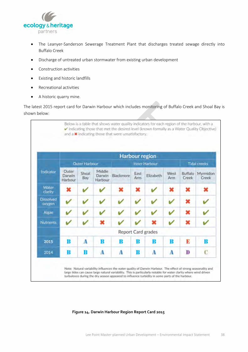
Lee Point Master-planned Urban Development – Environmental Impact Statement 38
The Leanyer-Sanderson Sewerage Treatment Plant that discharges treated sewage directly into
Buffalo Creek
Discharge of untreated urban stormwater from existing urban development
Construction activities
Existing and historic landfills
Recreational activities
A historic quarry mine.
The latest 2015 report card for Darwin Harbour which includes monitoring of Buffalo Creek and Shoal Bay is
shown below:
Figure 14. Darwin Harbour Region Report Card 2015

Lee Point Master-planned Urban Development – Environmental Impact Statement 39
4.3 Risk Assessment
4.3.1 Risk assessment summary
A summary of the risk assessment findings of the potential impacts the project will have on hydrological
values is provided below in Table 11. The summary includes those impacts which are considered to be of
High or Medium risk and necessitates mitigation measures to reduce the risk to an acceptable level. The full
results of the risk assessment are provided in Appendix C. The risk assessment was completed in accordance
with the methods described in Section 3.
Further information on the nature of the potential impacts and the type of mitigation measures proposed is
provided below in Section 4.3.2.
Table 11. Summary of risk assessment
Impact Description Mitigation measures
Surface water quality
The development of the site has the potential to impact on the water quality of the downstream receiving waters. Typical pollutants generated from development of the site include an increase in nutrient loads, sediments, gross pollutants and heavy metals and hydrocarbons for commercial/industrial land uses.
To mitigate the impacts of the development on discharged water quality it is proposed to incorporate Water Sensitive Urban Design (WSUD) principles and a stormwater treatment strategy that includes the use of bioretention basins, and vegetated swales/buffers for treatment. For more intense land-uses or areas that have limited space for treatment there is the potential to use proprietary treatment devices.
Water Quality Monitoring will be undertaken to ensure the project does not impact Sandy Creek.
Surface water flow rates
The increased impervious areas and drainage network incorporating underground pipes has the potential to increase peak flows discharging from the site into Sandy Creek..
It is proposed to incorporate on-site detention measures in the form of end-of-line detention basins and online detention utilising internal road crossings of drainage channels.
Erosion Erosion and sedimentation during construction and post-development
Erosion and Sediment Control Plan (ESCP), which will also include rehabilitation of large erosion gullies in the south-west of 2CRU.
Flooding
Notwithstanding inundation across the site from local catchment runoff resulting in shallow sheet flow and concentrated gully channel flows, other potential sources of inundation could occur due to storm tide inundation given the proximity of the site to Beagle Gulf.
The detailed drainage design of the development will incorporate both underground pipes and open channels to convey the site runoff though the development. To mitigate the potential increases in peak flows, on-site detention measures are also proposed. The design levels for the adjacent lots and roads will ensure adequate freeboard and trafficability respectively during the applicable design flood events. The majority of the site is above the 100 year Average

Lee Point Master-planned Urban Development – Environmental Impact Statement 40
Impact Description Mitigation measures
Recurrence Interval (ARI) storm tide level for 2100.
Litter, rubbish entering creeks and eventually Bay.
The development of the site has the potential to impact on the water quality of the downstream receiving waters. Typical pollutants generated from development of the site include gross pollutants.
The stormwater quality treatment measures proposed include the use of bioretention basins and vegetated swales/buffers. In addition, for more intense land uses, proprietary products including Gross Pollutant Traps (GPTs) are proposed. .
Groundwater quality Contamination through uncontrolled release during construction works
Preparation & implementation a CEMP which would include special response spill containment and response measures
Groundwater quality Contamination though sewage leaks/release
Site residences are connected to main sewage network, no septic systems. Design of sewerage system in accordance with City of Darwin and PWC’s requirements.
Lower groundwater recharge Lower groundwater recharge as a result of reduction of natural surfaces over the site potentially affecting GDEs
Reserve area on western side of the development. Retain Monsoon Rainforest patch in Muirhead North. Optimise natural areas throughout the area by the presence of natural reserves, parks and gardens. Water recharge increased through water infiltration at stormwater detention basin.
Acid sulphate soils
Acid sulphate soils have a low-medium potential to occur at the lowest elevations of the project site, that being the south-east corner of Muirhead North.
Complete test drilling in south-east corner of Muirhead Nort prior to commencing construction. If acid sulphate soils are encountered, prepare an acid sulphate soils management plan.
4.3.2 Description of impacts and mitigation
Mitigation measures proposed for the development include the use of WSUD principles.
The stormwater quality treatment measures to be adopted for the development include the use of
bioretention basins and vegetated swales/buffers. High density areas within the development such as the
commercial precinct may also incorporate proprietary treatment devices such as the Stormwater360
treatment system.
The impact of the development on stormwater quantity is to be mitigated by on-site by detention measures
in the form of end-of-line detention basins and online detention utilising internal road crossings of drainage
channels. Suitable scour and erosion protection measures will be incorporated at the outlets to any basins
and at locations where velocities are such that they have the potential to cause significant scour, such as
downstream of culvert crossings of roads. These scour protection measures will be in the form of a
combination of rock protection, gabions and/or flow spreaders.

Lee Point Master-planned Urban Development – Environmental Impact Statement 41
The risks to groundwater are considered to be low. Standard spill management procedures will be
implemented as part of the CEMP. In the highly unlikely event that pollutants enter the groundwater they
could be removed using standard remediation procedures. There is unlikely to be any change in recharge,
and as such GDEs should not be affected.
4.3.2.1 Groundwater
Potential impacts from groundwater can be classified in three chronological categories:
Impacts arising from previous activities, primarily associated with potential contamination
Impacts to groundwater during construction activities
Impacts to groundwater arising from residential use of the site.
The risks associated with previous site activities have been assessed (GHD 2014). GHD reviewed the site
historical activities and potential contamination and concluded that there was no soil and groundwater
contamination at the site.
Risks to groundwater during construction activities are associated with accidental spills and contamination.
The contaminant would need to enter the subsurface and then propagate down through the laterite profile
to the water table and affect water quality of the aquifer and receiving water bodies.
The risk to groundwater from residential activities lays more with the disposal of sewage than inhabitants’
activities themselves.
Impacts to water quality groundwater during construction activities
In the case of uncontrolled spills, the chemical characteristics of the contaminant are most likely to be from
the hydrocarbons family and as such can easily be identified from natural groundwater and surface water
settings.
It is highly unlikely that an accidental spill would result in an impact on groundwater quality at the site for the
following reasons:
Any construction activity would have to follow the CEMP which would include special response spill
containment and response measures.
The contamination would initially be limited to the soil and upper unsaturated aquifer profile, where
remediation by removal of the contaminated soil/rock is very effective.
Should the regional groundwater be affected, the chemical release is estimated to be quite minor
(small source of contamination over a very short period) and through natural attenuation would
rapidly become insignificant or undetectable.
For the same reasons, it is highly unlikely that an accidental spill would result in an impact to aquifer water
quality.
As a result, there will be no impact to groundwater from construction activities provided suitable spill
response and control measures are in place during construction.

Lee Point Master-planned Urban Development – Environmental Impact Statement 42
Impacts to water quality arising from residential use of the site
The project site is planned to be developed as residential development, commercial development,
community facilities and conservation areas. The development will benefit from the connection to main
sewer services. As a consequence, there is no risk associated with on-site treatment of sewage.
Impacts to groundwater dependent ecosystems
Impacts to GDEs that potentially occur along the western boundary of 2CRU, and the eastern section of
Muirhead North, could be associated with a decrease of supply (i.e. decrease of the level of the water table)
due to a reduced area for groundwater recharge. The development proposal will retain the Monsoon Vine-
thicket area as part of the Casuarina Coastal Reserve, and the Monsoon Rainforest patch in Muirhead North.
The GDE Atlas identifies other vegetation types in the eastern section of Muirhead North, which is likely to
be partially cleared as part of the rural alotments. It should be noted that groundwater dependency will
require the rooting system to reach to the water table. This is only likely to occur at low and mid-slope in the
Monsoon Vine-thicket area.
The reduction in recharge due to the replacement of permeable surfaces with hardstand areas will reduce
recharge, although this will be counterbalanced by reduced evapotranspiration and localised recharged at
utility trenches. In addition, the proposed development optimises the use of natural areas and the presence
of bio-retention basins upstream of the Monsoon Vine-thicket and Monsoon Rainforest patch (see Figure 5
in Appendix E and Appendix F) will provide added recharge to the groundwater system. As a result, the
likelihood of a significant recharge reduction is estimated to be low. The risk of impact to GDEs is rated low
(Rare likelihood x Major consequence). The “major” consequence classification relates to the interest of the
Northern Territory in maintaining this type of vegetation.
Ongoing monitoring of the health of the Monsoon Vine-thicket and Monsoon Rainforest patches will be
conducted to infer any potential impact associated with reduced groundwater recharge (see Section
7.3.2.10).
4.3.2.2 Stormwater
Development of the project site has the potential to:
Release sediment and potential contaminants into receiving waters as a result of vegetation clearing
and/or excavation
Adversely impact fish and other aquatic species that may inhabit Sandy Creek due to increased
turbidity and/or release of contaminants during construction, or increased pollutant loads from road
runoff during operation
Impact roosting and feeding habitat for migratory shorebirds at the mouth of Sandy Creek
Contaminate water in the event of fuel or oil spills during construction and operation.
The potential for the development to impact on Buffalo Creek is considered low, given the existing poor
condition of Buffalo Creek, and stormwater treatment and ESCP measures that will be implemented.
The majority of potential water quality and quantity related impacts can be adequately managed with
effective implementation of the mitigation measures outlined in the following section to meet specific Water
Quality Objectives (WQOs). These measures include bioretention systems, vegetated swales/buffers, erosion

Lee Point Master-planned Urban Development – Environmental Impact Statement 43
and sediment control and proprietary devices. Water quality will also be monitored at the three discharge
locations as well as in Sandy Creek and Buffalo Creek (Appendix O).
Construction Phase Water Quality
During the construction phase, the potential exists for increases in the amount of pollutants, particularly
sediment, exported from the site. During this period, an ESCP will be referred to as part of the overall CEMP
prepared for the construction phase.
It is considered that the completion of construction activities in accordance with an ESCP developed using
latest version of the following guidelines will minimise the nature of any adverse impacts during the
construction phase and allow the design objectives to be achieved:
IECA.2008, Best Practice Erosion and Sediment Control- Engineering Guidelines for Queensland
Construction Sites.
Institution of Engineers Australia.1996, Soil Erosion and Sediment Control, Engineering Guidelines
for Queensland Construction Sites. June.
Please refer to Appendix D for further details of the ESCP.
Post-Construction Phase Water Quality
The formulation and implementation of the stormwater quality management plan for the development is
based on the following key principles:
Adoption of WSUD principles where feasible.
Management and control of water quality both during and after construction. A detailed ESCP will be
developed in accordance with recognised standards during the detailed design phase and
implemented on site during the subdivision construction process.
A copy of the Stormwater Management Plan is provided in Appendix E (2CRU) and Appendix F (Muirhead
North).
Proposed Stormwater Quality Treatment Train
The treatment measures outlined in the Stormwater Management Plan include the use of Ecosol Net
Guards, bioretention basins and vegetated swales/buffers. High density areas within the development such
as the tourism/commercial precinct may also incorporate proprietary treatment devices such as the
Stormwater360 treatment system. The preliminary locations for the proposed treatment measures are
shown in the Stormwater Management Plans (Appendix E and Appendix F).
To minimise the size of the bioretention areas, it is proposed to incorporate the proprietary treatment
product by Ecosol being the Net Guard as pre-treatment to the bioretention basins. The Net Guard will
primarily treat the Total Suspended Solids (TSS) and Gross Pollutants (GP) with some additional pollutant
removal of Total Nitrogen (TN) and Total Phosphorus (TP). The recommended pollutant removal efficiencies
have been provided by the manufacturer and listed below:
TSS – 40% removal
TN – 30% removal

Lee Point Master-planned Urban Development – Environmental Impact Statement 44
TP – 35%
GP – 93%
The preliminary details of the bioretention basins are detailed in Table 12 with the locations of the
bioretention basins are shown in the Stormwater Management Plans (Appendix E and Appendix F).

Lee Point Master-planned Urban Development – Environmental Impact Statement 45
Table 12. Bioretention details for 2CRU (Bio-Basin A-E) and Muirhead North (Bio-Basin F-I)
Parameter Bio-Basin A
Bio-Basin B
Bio-Basin C
Bio-Basin D
Bio-Basin E
Bio-Basin F
Bio-Basin G
Bio-Basin H
Bio-Basin I
Extended Detention Depth (m)
0.3 0.3 0.3 0.3 0.3 0.3 0.3 0.3 0.3
Surface Area (m2) 900 700 700 900 650 750 1050 600 600
Filter Media Surface Area (m2)
900 700 700 900 650 750 1050 600 600
Saturated Hydraulic Conductivity (mm/hr)
200 200 200 200 200 200 200 200 200
Filter Depth (m) 0.6 0.6 0.6 0.6 0.6 0.6 0.6 0.6 0.6
TN Content (mg/kg) 400 400 400 400 400 400 400 400 400
Orthophosphate Content (mg/kg)
30 30 30 30 30 30 30 30 30
It should be noted that the maximum bioretention area is recommended to be 800m2 for both ease of
maintenance and to aid the survival of bioretention vegetation during extended dry periods. The limiting
pollutant in sizing most of the bioretention areas is TSS, with the use of proprietary pre-treatment devices
such as Ecosol’s Net Guard product, the overall size of the bio-retention basins could be reduced.
It is noted that the use of rainwater tanks for re-use of rainwater could also potentially reduce the pollutant
loads discharging from the site while also reducing demand on town water supply. However, imposing this
requirement on potential property buyers is not easily enforced and has therefore not been included as part
of the treatment train.
The stormwater treatment train has been designed to discourage breeding and providing habitat for biting
insects. The Stormwater Management Plans have been developed to comply with the recommendations set
out in the Biting Insect Report prepared specifically for this project (Appendix G).
Design and Performance of Treatment Measures
In order to determine the effectiveness of the adopted treatment train in meeting the WQOs, a stormwater
quality analysis was performed using the Model for Urban Stormwater Improvement Conceptualisation
(MUSIC) Version 6.
The model requires the user to specify meteorological data (rainfall and evaporation), soil properties and
pollutant loads for each catchment. Suitable parameters for the MUSIC model have been adopted in
accordance with the recommendations within the Water Sensitive Urban Design Stormwater Quality
Modelling Guide, May 2009 prepared by the Northern Territory Department of Planning and Infrastructure.
The Urban Residential Source node has been adopted within the MUSIC modelling. Further, the
development has been divided into roof areas, road areas and general urban based on the applicable Source
Node land use. The pollutant export parameters adopted are shown in Table 13.
The rainfall data applied to the MUSIC model was for the Darwin Airport rainfall station for the period 1987-
1996. A 6 minute time step was considered for the analysis.

Lee Point Master-planned Urban Development – Environmental Impact Statement 46
Table 13. Stormwater Quality Parameters for MUSIC Source Nodes
Source Node TSS (log10 values) TP (log10 values) TN (log10 values)
Mean St. Dev. Mean St. Dev. Mean St. Dev.
Baseflow
Roof 1.1 0.17 -0.82 0.19 0.32 0.12
Roads 1.1 0.17 -0.82 0.19 0.32 0.12
General Urban
1.1 0.17 -0.82 0.19 0.32 0.12
Stormflow
Roof 1.55 0.39 -0.92 0.29 0.42 0.19
Roads 2.38 0.40 -0.60 0.50 0.42 0.19
General Urban
2.20 0.32 -0.45 0.25 0.42 0.19
Catchment Areas
Catchment areas and percentage impervious values were determined as part of the Stormwater
Management Plans (see Appendix E and Appendix F). The adopted catchment characteristics are given in
Table 14.
Table 14. Catchment areas for 2CRU (Catchment A-E) and Muirhead North (Catchment F-I)
Catchment Total % Impervious
A 14.33 42
B 11.91 49
C 9.43 67
D 12.26 67
E 9.37 60
F 12.20 50
G 16.24 57
H 10.70 16
I 9.81 17
The results of the MUSIC modelling, shown as total annual loads, are presented in Table 15 (2CRU) and Table
16 (Muirhead North). The results demonstrate that the proposed stormwater treatment measures for the
development will satisfy the adopted WQO for all pollutants modelled in MUSIC. Stormwater Quality and
therefore the COD criteria for water quality have been appropriately addressed.
Table 15. Predicted Pollutant Load Reductions – 2CRU
Parameter Generated Load Post-development (Mitigated) Load
% Reduction
TSS (kg/yr) 123000 24200 80.3
TP (kg/yr) 256 71.3 72.1

Lee Point Master-planned Urban Development – Environmental Impact Statement 47
TN (kg/yr) 1850 791 57.1
Gross Pollutants (kg/yr) 14100 1.24 99.9
Table 16. Predicted Pollutant Load Reductions – Muirhead North
Parameter Generated Load Post-development (Mitigated) Load
% Reduction
TSS (kg/yr) 83000 16100 80.6
TP (kg/yr) 177 48.1 72.8
TN (kg/yr) 1300 545 58
Gross Pollutants (kg/yr) 9460 0 100
Stormwater Quantity
The intensified development of the site has the potential to increase local site runoff due to the increase in
impervious areas associated with the development. This potential increase in local peak flows can ultimately
result in increased peak discharges within the adjacent waterways that can result in increased flood levels,
erosion of the waterway and affect bank stability.
To limit the adverse impacts external to the developed site, it is required to limit post-development flows
from the site to less than pre-development levels using appropriate mitigation measures where possible.
To mitigate the potential increase in flows discharging from the project site, it is proposed to include end-of-
line detention basins at the outlet to the site’s three major outlets located as shown in the Stormwater
Management Plan for 2CRU (Appendix E) and Muirhead North (Appendix F).
Modelling undertaken as part of the Stormwater Management Plans showed that without mitigation the
peak flows would increase at three out of five of the outlets (Table 17). When considering the impact of the
development on both the rainforest patch and rural dam, it is anticipated that the volume of the more
frequent runoff events would be the critical hydrologic factor in maintaining the health and demand for the
respective receiving environments. Given that the antecedent catchment condition is considered the same in
both the pre and post-development scenarios, there should ultimately be no impact on runoff volume to the
respective receiving locations if the contributing catchment area is maintained.
It should be noted that the health of the Monsoon Rainforest patch will be monitored to infer whether
stormwater flows are appropriate for sustaining the patch. If the stormwater flows are not considered
tolerable than changes to the stormwater treatment system will be considered, which most likely would
include removing bioretention basins and replacing with Gross Pollutant Traps to increase baseflows in to
the Monsoon Rainforest whilst still treating stormwater for nitrogen and phosphorous pollution.
Table 17. Impact on 100 Year ARI Peak Flows for 2CRU (RP01 and RP04) and Muirhead North (RP05, RP06 and RP5)
Sub-catchment Outlet
Pre-development
XPRAFTS Q100 Peak Flow
Post-development (Unmitigated)
XPRAFTS Q100 Peak Flow
Increase in Peak Flows (m
3/s)
Impact (%)

Lee Point Master-planned Urban Development – Environmental Impact Statement 48
(m3/s) (m
3/s)
RP01 – North West 2.51 4.50 1.99 79
RP04 – South West 9.46 19.26 9.80 104
RP05 – To Rainforest Patch
7.44 3.46 -3.98 -53
RP06 – To Rural Dam 3.92 1.86 -2.06 -53
RP5 – Buffalo Creek outlet
27.07 31.23 4.16 15.4
The Stormwater Management Plans includes mitigation in the form of bioretention and detention basins to
ensure that peak flows are not impacted by the project. To ensure the rural dam supply is maintained by
regular runoff from the upstream catchment, it is proposed to divert all flows up to the 2 year ARI event
(1.86m3/s and 3.46m3/s) to the existing drains that conveys flows to the rural dam and rainforest patch in
Muirhead North respectively. The 2 year ARI peak flow was selected based on the existing cross drainage
culvert of Lee Point Road expected to have a minimum 2 year ARI capacity and preliminary estimates of the
capacity of the drain. The balance flows from the developed catchment will be diverted to link with the main
drainage path to the south.
Preliminary design of the detention basins has been undertaken assuming the following criteria:
1 in 6 batters to facilitate maintenance of the batters, assumed to be turfed;
Basins initially assumed to be trapezoidal with a width:length ratio of 1:2;
Maximum depth within each basin to be 1.2m for the 20 year ARI event for public safety. Deeper
basins may be possible with appropriate signage and fencing and approval from the City of Darwin;
and
Post-development peak flows to be mitigated to pre-development peak flows for all events from the
2 to 100 year ARI.
For the catchment discharging to the south-west corner of the 2CRU, two individual detention basins have
been designed to maintain existing peak flows in the two defined gullies immediately downstream rather
than a single outlet which would potentially result in additional erosion in a single gully.
For the catchment discharging to the north of the project site, a detention basin has been designed to
maintain existing peak flows.
The detention basin outlets are detailed in Table 18 with the stage-storage relationships shown in Table 19.
Table 18. Detention Basin Details
Basin ID Outlet Pipes
High Flow Weir Width at 100 Year Level (m)
20 Year Depth in Basin (m)
100 Year Depth in Basin (m)
Surface Area at 100 Year Level (m
2)
Volume at 100 Year Level (m
3)
Basin 1 1 / 1200 x 600
RCBC 1.80 1.07 1.33 3,300 3,600

Lee Point Master-planned Urban Development – Environmental Impact Statement 49
Basin ID Outlet Pipes
High Flow Weir Width at 100 Year Level (m)
20 Year Depth in Basin (m)
100 Year Depth in Basin (m)
Surface Area at 100 Year Level (m
2)
Volume at 100 Year Level (m
3)
Basin 2 1 /1200 x 600
RCBC 1.80 1.04 1.25 3,200 3,350
Basin 3 2 / 1200 x 600
RCBC 1.80 1.04 1.45 15,950 22,050
Basin 4 7 / 1.5 x 0.9 RCBC 1.80 1.18 1.26 12,800 15,714
Table 19. Proposed Detention Basin Stage-Storage Relationships
Stage (m) Basin 1
Storage (m3)
Basin 2
Storage (m3)
Basin 3
Storage (m3)
Basin 4
Storage (m3)
0.00 0 0 0 0
0.20 511 511 3,451 3,451
0.40 1,021 1,021 6,696 6,696
0.60 1,526 1,526 9,702 9,702
0.80 2,018 2,018 12,422 12,422
1.00 2,551 2,551 15,194 15,194
1.20 3,149 3,149 18,177 18,177
1.40 3,799 3,799 21,277 21,277
1.60 4,508 4,508 24,500
The resulting mitigated peak flows at each reporting point for all design events are presented in Table 20 to
Table 22 and demonstrate that the detention basins will attenuate the increase in run-off associated with
the increase in impervious areas, and maintain peak flows at or slightly below pre-development levels.
Table 20. 100 and 50 Year ARI Peak Discharge (m3/s)
Reporting Point
100 Year ARI 50 Year ARI
Pre-developed Mitigated
Post-developed
Impact Pre-developed Mitigated
Post-developed
Impact
RP01 2.51 2.05 -0.46 2.21 1.88 -0.33
RP02 2.91 2.27 -0.64 2.58 2.09 -0.49
RP03 6.38 4.70 -1.67 5.67 4.15 -1.53
RP04 9.46 6.90 -2.56 8.44 6.17 -2.27
RP05 7.44 3.46 -3.98 6.58 3.46 -3.12
RP06 3.92 1.86 -2.06 3.48 1.86 -1.62
Table 21. 20 and 10 Year ARI Peak Discharge (m3/s)
Reporting 20 Year ARI 10 Year ARI

Lee Point Master-planned Urban Development – Environmental Impact Statement 50
Point
Pre-developed Mitigated
Post-developed
Impact Pre-developed Mitigated
Post-developed
Impact
RP01 1.85 1.66 -0.19 1.56 1.46 -0.10
RP02 2.25 1.89 -0.36 1.94 1.67 -0.28
RP03 4.83 3.44 -1.39 4.09 2.66 -1.43
RP04 7.27 5.24 -2.03 6.22 4.22 -2.00
RP05 5.64 3.46 -2.18 4.84 3.46 -1.38
RP06 3.02 1.86 -1.16 2.59 1.86 -0.73
Table 22. 5 and 2 Year ARI Peak Discharge (m3/s)
Reporting Point
5 Year ARI 2 Year ARI
Pre-developed Mitigated
Post-developed
Impact Pre-developed Mitigated
Post-developed
Impact
RP01 1.41 1.32 -0.09 1.11 1.05 -0.06
RP02 1.76 1.51 -0.24 1.44 1.21 -0.23
RP03 3.66 2.01 -1.66 2.97 0.75 -2.23
RP04 5.60 3.39 -2.21 4.54 2.05 -2.49
RP05 4.33 3.46 -0.87 3.46 3.46 0.00
RP06 2.32 1.86 -0.46 1.86 1.86 0.00
.

Lee Point Master-planned Urban Development – Environmental Impact Statement 51
4.3.2.3 Acid Sulphate Soils Testing for acid sulphate soils has not been undertaken. Despite the proximity of the project site to the
coastline, the elevation of the site is likely to preclude the presence of acid sulphate soils (GHD 2010). If
present, acid sulphate soils are most likely to occur in the lowest elevations of the site, which occurs in the
south-east of Muirhead North, which relates to Stage 2B. It should be noted that no acid sulphate soils were
encountered in the adjoining Muirhead Breezes development. Nonetheless, test pits will be dug in the south-
east of Muirhead North to determine the presence of acid sulphate soils prior to the development of Stage
2B. If acid sulphate soils are encountered than an acid sulphate soils management plan will need to be
prepared and implemented.

Lee Point Master-planned Urban Development – Environmental Impact Statement 52
5 AIR QUALITY
5.1 Introduction
This chapter assesses the potential impacts of the project on air quality, or existing air quality issues that may
affect the amenity for future residents. The chapter specifically focusses on dust generation and odour and
addresses the following criteria of the EIS ToR:
Potential impact from odour related to the proximity to the Leanyer Sanderson Wastewater
Treatment Ponds, supported by on site sampling and undertaken by a suitably qualified and
experienced consultant in accordance with AS/NS 4232.3:2001 or other demonstrated industry best
practice methodology.
Discuss the risks from dust and other particulate matter during construction activities and the
proposed mitigation of those risks.
The chapter is structured in the following manner:
Description of the methods used to model the magnitude of odour impacts, and likely impacts from
dust (Section 5.2).
A summary of the Identified odour and dusk risks to sensitive receivers and future residents and a
list of practical and appropriate mitigation measures to avoid any unacceptable dust or odour
disturbance that may occur during the construction or operation phase of the project (Section 5.3).
The full risk assessment is provided in Appendix C. The findings of odour impacts are based on the Odour
Impact Assessment prepared by The Odour Unit (2017), which is provided in Appendix .

Lee Point Master-planned Urban Development – Environmental Impact Statement 53
5.2 Existing Conditions
5.2.1 Odour methods
The methods used to establish the impact from odour focussed on the plume extent and odour intensity,
both of which were undertaken using industry best-practice standards. Field staff who undertook odour
measurements in the field are registered assessors in accordance with AS/NZS4323.3:2001 Dynamic
Olfactometry. Meteorological data was also recorded during the assessment to aid interpretation.
5.2.1.1 Plume extent
Establishing the plume extent was based on the internationally recognised European Standard: EN 16841-
2:2016 using the dynamic plume method. At least 20 single measurements were taken at different distances
downwind from the Leanyer Sanderson Wastewater Treatment Plant by at least two assessors in order to
define at least six transition points and the odour plume extent. Assessors walked in a zig-zag fashion into
and out of the defined plume to prevent adaptation to the odour. The maximum extent of the plum is
determined by assessors repeatedly crossing the plume at different distances from the source. The spatial
location of each measurement point is recorded, along with the time and whether or not the odour could be
detected.
5.2.1.2 Odour Intensity
Once the plume extent was defined, the assessors determine the odour intensity based on the
internationally recognised German Standard: VDI 3940, 3882 Part 1. Assessors conducted measurements at
discrete points downwind of the Leanyer Sanderson Wastewater Treatment Plant, involving 60 grab
measurements for 10 sections for a single measurement cycle of 10 minutes. Each measurement provided a
single odour sample, where assessors determined the presence, character and intensity of the odour.
The odour intensity is determined using the categories in the table below.
Table 23. German Standard VID 3940, 3882 Part 1 – Odour Intensity Categories
Odour Strength Intensity Rank (code) Interpretation
Not detectable 0 No odour detected.
Very weak 1 Odour recognised and assigned to the odour source (recognition).
Weak 2 Odour is weak but not yet distinct.
Distinct 3 Odour is clearly distinct.
Strong 4 Strong odour detectable.
Very strong 5 If offensive, observer may consider moving from the area.
Extremely strong 6 Odour is sufficiently over-powering that assessor moves from area.

Lee Point Master-planned Urban Development – Environmental Impact Statement 54
5.2.2 Odour impacts
Odour was not detected within the project site. The plum extent was established on 25 February when winds
were originating from the east. The plume barely extended beyond the boundary fence line of the Leanyer
Sanderson Water Treatment Plant. The odour intensity was low (less than intensity rank 4 – Table 23), and
the plume was narrow and intermittent. The downwind extent of the plume was estimated to be 500-600
metres and 150 metres wide. These results indicate that the Leanyer Sanderson Water Treatment Plant does
not provide an odour impact to the project site.
The assessment was undertaken towards the end of February 2017, which was considered suitable as there
had been little rain preceding the assessment, meaning there had been no dilution or flushing of sewerage
from the Leanyer Sanderson Wastewater Treatment Plant which could reduce the magnitude of odour
impact.
5.2.3 Dust
Dust generation can occur during the construction phase of urban development projects. It is more likely to
occur in the dry season when drier soils and particulate matter more readily become airborne during
disturbance. The likely causes of dust generation for this project are:
Clearing vegetation
Construction works
Vehicle movements
Erosion.
The risks and impacts of dust generation associated with this project have been established from referring to
projects of a similar nature and guidelines for dust prevention in Australia. The potential impacts of dust
generation can include:
Human health (respiratory problems)
Exposure to contaminants (e.g. asbestos)
Vegetation smothering restricting carbon uptake and transpiration
Loss of amenity
Sedimentation leading to reduced water quality.
Depending on the extent of the dust plume, onsite workers and adjoining residents can be affected during
construction, while if proper remediation and mitigation solutions are not in place, dust management
problems can remain after the construction phase.

Lee Point Master-planned Urban Development – Environmental Impact Statement 55
5.3 Risk Assessment
5.3.1 Risk assessment summary
The section summarises the findings of the detailed risk assessment, and identifies those risks which require
management and mitigation measures to reduce the level of risk of dust generation and odour to the
environment and human health, to an acceptable level.
Based on the results of the odour assessment, the risk of odour impact on the project development is low-
negligible. The odour plume was measured as extending up to 600 metres from the Leanyer Stormwater
Treatment Plant, and at low intensity (i.e. distinct/not very distinct and not offensive). The closest point-to-
point distance between the project site and the Leanyer Sanderson Wastewater Treatment plant is
approximately 1 km. Odour was also not detected throughout the project site during the assessment.
Due to the low-negligible risk of odour impact to future residents of the project site, mitigation or
management measures are not considered necessary. As such, the summary of the risk assessment focusses
on dust impacts.
A summary of the moderate to high risks of dust impacts are summarised in Table 24. The potential for dust
generation to result in contamination is unlikely, as the original site sheds have been demolished and
removed in accordance with standard Occupational Health and Safety procedures to avoid any potential
exposure to contaminants, such as asbestos. However, two 450 metre long parallel asbestos pipes remain in
2CRU and will be removed as part of the development.
The full risk assessment results for dust impacts are provided in Appendix D.
Table 24. Summary of risk assessment for dust impacts and recommended mitigation measures
Impact Description Considered Mitigation Measures
Human health (workers and adjoining residents).
Dust plumes causing respiratory problems.
Removal of 450 m long parallel asbestos pipes in 2CRU to be done by a trained and certified asbestos removal company.
Notify adjoining residents prior to works commencing
Vegetation cleared in a staged manner
Limit the amount of excavation required to clearing vegetation
Watering on haul roads, and exposed areas
Vehicles obey speed limits and stick to formed road
Trafficable areas clearly marked
Stabilise long exposed areas
Rehabilitate as soon as possible.
Vegetation Dust plumes smother vegetation preventing adequate carbon sequestration and transpiration.
Vegetation cleared in a staged manner
Limit the amount of excavation required to clearing vegetation
Watering on haul roads, and exposed areas
Vehicles obey speed limits and stick to formed

Lee Point Master-planned Urban Development – Environmental Impact Statement 56
Impact Description Considered Mitigation Measures
road
Trafficable areas clearly marked
Stabilise long exposed areas
Rehabilitate as soon as possible.
Water foliage of affected vegetation as part of watering plan.
Sedimentation of waterways
Reduction in water quality due to erosion and sedimentation.
Vegetation cleared in a staged manner
Limit the amount of excavation required to clear vegetation
Watering on haul roads, and exposed areas
Vehicles obey speed limits and stick to formed road
Trafficable areas clearly marked
Stabilise long exposed areas
Rehabilitate as soon as possible
WSUD
Avoid clearing in wet season during monsoonal rains
Water quality monitoring of detention basins and Sandy Creek.
Human health (future residents)
Exposed areas remain after construction has been completed causing ongoing dust impacts
All exposed soil areas are covered either by hard surface (roads, pathways or buildings) or vegetation.
Ongoing maintenance of public open space will include rehabilitation of any exposed areas through revegetation or passive regeneration of existing vegetation.
5.3.2 Description of impacts and mitigation measures
The types of mitigation measures proposed are consistent with responses for other urban development
projects of a similar scale in the Northern Territory. The potential of dust impacts are most prevalent during
the construction phase, when plant operation and vegetation clearing can result in dust generation
particularly during the dry season. To ensure that dust generation is contained and that site workers and
adjoining residents are not affected, the following mitigation measures are considered sufficient:
Notify residents prior to works commencing
Clearing vegetation in a staged manner
Water haul roads and exposed areas
Vehicles obey speed limits and stick to form roads
Stabilise any long-exposed areas
Rehabilitate as soon as possible.
In addition, the proposed removal of 450 m long parallel asbestos pipes in 2CRU represents a significant risk
to human health and will only be done by a trained and certified asbestos removal company.

Lee Point Master-planned Urban Development – Environmental Impact Statement 57
These mitigation measures are further detailed in the ESCP which forms part of the over-arching CEMP
(Appendix D).
Dust generation can also result in the sedimentation of waterways. The treatment train of bioretention and
detention basins that will be established throughout the project site have been designed to remove up to
80% of the sediment captured from the project area, and will assist with mitigating any dust impacts from
the project. See the Stormwater Management Plan for 2CRU (Appendix E) and Muirhead North (Appendix F)
for further detail.
Dust generation can also impact on biodiversity by smothering vegetation and preventing adequate
exchange of carbon and water through leaf stomata. The retention of 21.95 ha of remnant vegetation along
the western boundary of the site will buffer the interior of the Casuarina Coastal Reserve against any dust
impacts. Any affected vegetation along the edge of the retained area, and any other areas where native
vegetation will be retained, will be watered if signs of dust impacts become apparent.

Lee Point Master-planned Urban Development – Environmental Impact Statement 58
6 UTILITIES AND INFRASTRUCTURE
6.1 Introduction
This chapter describes the utilities and infrastructure that will be required to service the future inhabitants
and users of the project site. It covers the following service requirements:
Potable water
Sewerage
Transport
Power
Telecommunications.
The chapter is structured in the following manner:
Existing conditions and impacts – an assessment of the future demand requirements for potable
water (see Section 6.2.1), sewerage (see Section 6.2.2), transport (see Section 6.2.3), power (see
Section 6.2.4) and telecommunications (see Section 6.2.5); whether existing services can meet this
demand, and what impact increased demand is likely to have on the local community.
Risk assessment – a summary of the detailed risk assessment identifying key risks that require
mitigation or management measures, such as augmenting existing services or improving traffic
safety (see Section 6.3).
As part of the preparation of this chapter, the following people from Power and Water Corporation (PWC)
were consulted:
Ian Jong – Services Development Engineer
Jack Foster –Water Systems Engineer.
6.2 Existing Conditions and Impacts
6.2.1 Potable Water
The proposed development is located within the Casuarina Water Supply Zone (WSZ). Storage for the zone is
facilitated by the Marrara and Casuarina Reservoirs. A trunk network extends along Lee Point Road to supply
the network. In particular a DN (Diameter Nominal/Nominal Diameter) 450 main extends along Lee Point
Road in the vicinity of the existing Lyons and Muirhead developments.
In regard to network planning, PWC has advised that no new trunk services are proposed in the vicinity of
the site. This includes both storages and trunk mains. New storages are proposed at the Marrara Complex;
however, no bulk strategic planning will impact the proposed development.
Supply to the proposed development will be via the existing trunk main network along Lee Point Road.

Lee Point Master-planned Urban Development – Environmental Impact Statement 59
PWC provided boundary conditions that reflected hydraulic grades at the agreed offtake points to the
development. PWC provided boundary conditions for both the existing and ultimate network conditions. The
existing conditions nominally represent the network as it is in operation now. The ultimate conditions
represent network conditions infrastructure to service demand up to 50 years in the future. The advised
grades are:
Existing: Peak Hour 51.4m Australian Height Datum (AHD) , Fire Flow 53.9m AHD
Ultimate: Peak Hour 48.46m AHD, Fire Flow 51.6m AHD.
Based on this information, a water supply network model has been developed that includes the agreed
offtake points, supply mains from the offtake point to the development and an internal reticulation network.
The water supply network was built in the hydraulic modelling software, Bentley WaterGEMS. This software
allows the infrastructure to service the development to be sized according to the PWC design criteria.
A new DN450 trunk main was assumed to continue from the proposed connection along Lee Point Road to
the second proposed junction, corresponding to a location immediately south of the Lee Point Village Resort.
In addition, a second connection to the existing DN300 main along Damabila Drive (south of the project site
in the Lyons development) was also assumed. An internal trunk main connected both the DN450 and DN300
mains via a looped DN300 trunk main.
Smaller reticulation services ranging in size from DN200 to DN150 are proposed. The network in the vicinity
of the proposed tourist precinct includes looped DN300 and DN200 mains to maintain fire flow
requirements.
The analysis of the existing network against the full demand indicated that sufficient pressure can be
maintained for both peak hour and fire flow events in the described network without augmentation. It is
noted that areas above 28 m AHD experienced pressures in the order of 19 m and 20 m. These are limited to
the northern lots. Provision of additional pressure boosting has not been proposed, given the system’s
capacity to accommodate firefighting requirements.
The network proposed for the existing scenario was assessed for the ultimate scenario with the reduced
level of hydraulic grade at the nominated offtake point. Analysis has indicated that the minimum level of
service could not be maintained, based on both growth and topography. Based on the adopted development
layout and external supply configuration, the creation of a high level zone (HLZ) for the entire site is
proposed.
Advice from PWC indicates a preference for storage over direct inline pressure boosting only. To
accommodate this preference the use of a break of head tank prior to boosting is proposed.
It is proposed that a HLZ be created to ensure the entire site receives a service level that satisfy PWC’s
requirements. This HLZ will be serviced via a small break of head tank with 650 kL storage, based on the
minimum fire flow requirements.

Lee Point Master-planned Urban Development – Environmental Impact Statement 60
6.2.2 Sewerage
The existing wastewater network in the vicinity of the project site includes the Lyons and Muirhead sewer
pump stations (SPS). These pump stations convey flows to the trunk sewer mains that discharge to the
Leanyer Sanderson Wastewater Treatment Plant.
PWC adopt Equivalent Persons (EP) as the basis for sewerage planning. Based on the adopted master plan,
the proposed development comprises 2,516 EP.
PWC has advised that no future trunk network augmentations have been identified downstream of the site.
However, the Leanyer Sanderson Wastewater Treatment Plant (LSWTP), in line with PWC’s regional
approach, will be upgraded within the next five (5) years. PWC has advised that the proposed augmentation
has allowed for the sewerage loading from the proposed development. Therefore, no assessment of the
LSWTP has been undertaken.
Based on the topography of the site, the development site falls within two pump station catchments, the
Muirhead SPS and the Lyons SPS. The majority of the development (2,106 EP) will discharge to the existing
Muirhead SPS catchment and the remainder (410 EP) will discharge to the Lyons SPS catchment.
A network model of the reticulation internal to the development site and the gravity mains connecting the
development to the two sewer pump stations was developed in Microsoft Excel to allow the gravity network
to be sized utilising the PWC design criteria. The gravity mains were sized based on the following
assumptions:
Gravity mains at minimum grade
Sized for pipe full.
An internal gravity network ranging in size from DN150 to DN375 is proposed for the site. The eastern part of
the catchment (2,106 EP) will drain to the Muirhead SPS via a DN375 trunk main and the western part of the
catchment (410 EP) will drain to the Lyons SPS via a DN225 trunk main.
An assessment was undertaken to determine the impact of the development on the existing infrastructure.
The existing Muirhead SPS was designed with consideration for the proposed development. The design of
the Muirhead SPS adopted a load of 2,747 EP for all future development in the catchment. The proposed
development, a projected 2,106 EP, will be discharging to the Muirhead SPS. Therefore the existing pump
station is within the original limits. The pump station was designed for a peak design flow of 103 L/s and an
emergency storage volume of 331 m3. The requirement (incorporating the reduction in the allowance from
the proposed development) is a peak design flow of 92 L/s and an emergency storage volume of 273 m3.
Therefore, the existing Muirhead SPS can accommodate the sewerage load from the proposed development.
The existing Lyons SPS was also designed with consideration for the proposed development. The design of
the Lyons SPS adopted a load of 550 EP from the proposed development, compared with the 410 EP for this
assessment. Therefore the existing pump station is within the original limits. However, a number of issues
were raised with the design as shown in Table 25. The analysis shows that although the design allowed for
up to 550 EP from the proposed development, this was not allowed for in construction. Therefore additional
emergency storage is required to satisfy PWC’s design criteria.

Lee Point Master-planned Urban Development – Environmental Impact Statement 61
Table 25. Analysis of Lyons Sewer Pump Station (SPS)
Parameter Design Requirement Comment Recommendation
Peak Design Flow
88 L/s 85 L/s Projected design flow is below previous design.
However, installed capacity is below design capacity.
Design Capacity
61 L/s (Single Pump)
88 L/s (Projected Dual Pump)
85 L/s Installed design capacity based on single pump capacity
Confirm pump arrangement. To accommodate peak design flow a duty/assist configuration would be required.
Emergency Storage Volume
290 m3 305 m3 Installed storages below original design requirement 315m3
Install additional 15m2 of emergency storage.
Additional redundancy may be included with provision of a hardstand for mobile generator for power outage.
6.2.3 Transport
A full Transport Impact Assessment (TIA) was conducted with the purpose of determining the overall impact
of the development on the surrounding road network along with the performance of nearby intersections
and the overall amenity of the area. The TIA has been prepared in accordance with the Austroads Guide to
Traffic Management Part 12: Traffic Impacts of Development. A summary of the main findings of the report
have been provided in the section below with the full reports available in Appendix .
6.2.3.1 Existing Traffic Conditions
The existing road network within the vicinity of the project site is limited, with the main road network
formed by Lee Point Road located to the east and Buffalo Creek Road located to the north.
A direct count traffic survey for the access to Lee Point Village Resort was conducted by SMEC in March 2015
(SMEC 2015). The traffic surveys indicated that the AM and PM peak hours for the Lee Point Resort access
road occurred from 7:30am – 8:30am and 5:45pm – 6:45pm, respectively. Traffic volumes at the Lee Point
Road/Buffalo Creek Road intersection were estimated using the volumes collected for the Lee Point Resort
access. The table below provides a summary of the existing traffic volumes.
Table 26. Traffic volumes for surrounding road network (SMEC 2015).
Location Date Average Two-way Traffic Volumes
Vehicles per AM Peak Hour Vehicles Per PM Peak Hour
Lee Point Village Resort March 2015 16 15
Buffalo Creek Road March 2015 28 58
Lee Point Road (At Lee Point Village Resort)
March 2015 35 94
Lee Point Road (At Buffalo Creek Road)
March 2015 18 48

Lee Point Master-planned Urban Development – Environmental Impact Statement 62
These traffic volumes indicate that congestion is not an issue in its current form for day-to-day operation.
This is a result of low levels of development within the area with the only traffic generators being the Lee
Point Village Resort, the beach at the northern end of Lee Point Road and the fishing spot at the western end
of Buffalo Creek Road.
6.2.3.2 Future Traffic Conditions (Post development)
The proposed development at 2CRU is expected to generate approximately 753 vehicles (two-way) to and
from the development during the peak hour periods. The Muirhead North development is expected to
generate approximately 409 vehicles (two-way) during the AM peak period and 319 vehicles (two-way)
during the PM peak to peak to period. The distribution of traffic to/from the 2CRU and Muirhead North has
been determined based on the location of the site in relation to nearby employment/commercial areas and
attractions. As the project site is located on the northern fringe of Darwin, it is assumed that the majority of
traffic generated will likely travel south towards the Darwin Town Centre. A small percentage of traffic is
expected to travel north to the Casuarina Coastal Reserve and Buffalo Creek boat ramp. In addition, vehicle
trips between the Muirhead North and 2CRU sites have only been considered for the school and active
recreation reserve land uses.
SIDRA Intersection 6.1 was used to evaluate the impact of the increased volumes anticipated for background
and full buildout scenarios. SIDRA Intersection is a software package used to analyse the capacity and
performance of road intersections. SIDRA outputs for each approach are presented in the form of Degree of
Saturation (DOS), Average Delay, Level of Service (LOS) and 95th Percentile Queue. These characteristics are
defined as follows:
Degree of Saturation (DOS): is the ratio of the arrival traffic flow to the capacity of the approach
during the same period. The Degree of Saturation ranges from close to zero for varied traffic flow up
to one for saturated flow or capacity. The theoretical intersection capacity is exceeded for an un-
signalised intersection where DOS > 0.80.
95% Queue: is the statistical estimate of the queue length up to or below which 95% of all observed
queues would be expected.
Average Delay: is the average of all travel time delays for vehicles through the intersection. An
unsignalised intersection can be considered to be operated at capacity where the average delay
exceeds 40 seconds for any movement.
LOS: is the qualitative measure describing operational conditions within a traffic stream and the
perception by motorists and/or passengers. The different levels of service can generally be described
in the table below.

Lee Point Master-planned Urban Development – Environmental Impact Statement 63
Table 27. Level of Service (LOS) descriptions
LOS Description Signalised Intersection Unsignalised Intersection
A Free-flow operations (best condition) ≤10 sec ≤10 sec
B Reasonable free-flow operations 10-20 sec 10-15 sec
C At or near free-flow operations
20-35 sec 15-25 sec
D Decreasing free-flow levels 35-55 sec 5-35 sec
E Operations at capacity 55-80 sec 35-50 sec
F A breakdown in vehicular flow (worst condition)
≥80 sec ≥50 sec
The following intersections were analysed:
Lee Point Road/Buffalo Creek Road
Lee Point Road/Lee Point Village Resort
Lee Point Road/Access Road 1
Lee Point Road/Access Road 2
Lee Point Road/Access Road 3.
A summary of the LOS outputs for 2CRU have been provided in the table below (Table 28). The results show
that all intersections performed satisfactorily in the AM and PM peak periods for all analysis scenarios. For
further details in regards to degree of saturation, 95% queue and average delay outputs, refer to the full TIA
report for 2CRU (Appendix ).
Table 28. Summary of Level of Service Outputs – 2CRU
1.0 INTERSECTION 2.0 LEVEL OF SERVICE (LOS)
Intersection 2017 without
development (AM/PM)
2027 without development
(AM/PM)
2017 with development
(AM/PM)
2027 with development
(AM/PM)
Lee Point Road / Buffalo Creek Road
LOS A/LOS A LOS A/LOS A LOS A/LOS A LOS A/LOS A
Lee Point Road / Lee Point Village Resort
LOS A/LOS A LOS A/LOS A LOS A/LOS A LOS A/LOS A
Lee Point Road / Access Road 1
N/A N/A LOS A/LOS A LOS A/LOS A
Lee Point Road / Access Road 2
N/A N/A LOS A/LOS A LOS A/LOS A
Lee Point Road / Access Road 3
N/A N/A LOS A/LOS B LOS A/LOS B

Lee Point Master-planned Urban Development – Environmental Impact Statement 64
A summary of the LOS outputs for Muirhead North have been provided in the table below. For further details
in regards to degree of saturation, 95% queue and average delay outputs, refer to the Muirhead North
Transport Impact Assessment report (Appendix L). The results show that all intersections performed
satisfactorily in the AM and PM peak periods for all analysis scenarios.
Table 29. Summary of Level of Service Outputs – Muirhead North
Intersection Level of Service (LOS)
Intersection 2019 without development (AM/PM)
2029 without development (AM/PM)
2019 with development (AM/PM)
2029 with development (AM/PM)
Lee Point Road / Buffalo Creek Road
LOS A/LOS A LOS A/LOS A LOS A/LOS A LOS A/LOS A
Lee Point Road / Lee Point Village Resort
LOS A/LOS A LOS A/LOS A LOS A/LOS A LOS A/LOS A
Lee Point Road / Access Road 1
LOS A/LOS A LOS A/LOS A LOS A/LOS A LOS A/LOS A
Lee Point Road / Access Road 2
LOS A/LOS A LOS A/LOS A LOS B/LOS A LOS B/LOS A
Lee Point Road / Access Road 3
LOS A/LOS B LOS A/LOS B LOS B/LOS B LOS B/LOS B
Lee Point Road / Access Road 4
N/A N/A LOS C/LOS C LOS C/LOS C
6.2.3.3 Proposed Road Network Upgrades – 2CRU
The proposed development at 2CRU introduces several upgrades within the surrounding area which include
the following:
Three new accesses to the project site along Lee Point Road. The configuration of these accesses are
as follows:
o Lee Point Road/Access 1 – stop priority intersection
o Lee Point Road/Access 2 – roundabout intersection
o Lee Point Road/Access 3 – roundabout intersection
An additional fourth access south of the project site connecting to Damabila Drive.
Improved amenity for right turn movements along Lee Point Road with the construction of medians
and right turn pockets at existing and proposed stop and give way priority intersections.
Cycling lanes along both side of Lee Point Road, this includes lanes passing through the roundabouts.
Shared/pedestrian footpaths along both sides of the road.
A local road network providing access to the residential dwellings as shown in the Site plan (Figure
15).

Lee Point Master-planned Urban Development – Environmental Impact Statement 65
The locations of the existing and proposed intersections near the project site are shown in Figure 16.

Lee Point Master-planned Urban Development – Environmental Impact Statement 66
Figure 15. Internal road network – 2CRU

Lee Point Master-planned Urban Development – Environmental Impact Statement 67
Figure 16. Existing and proposed access points – 2CRU
The timing for construction is intended to commence in the 2017 dry season and nominally one stage per
year to be released. The staging and timing are subject to change due to the environmental approvals
process and commercial assessment. It is likely that all transport related infrastructure listed above will be
constructed alongside the development.
The road network, bus routes, pedestrian paths and bicycle paths will be constructed by the developer in
conjunction with each stage of the development over a nominal 4 year period. The City of Darwin will be
responsible for maintenance of the road and path network. Public bus services are provided by the NT
Government. The proposed bus route is along the collector road on the western perimeter of the
development.

Lee Point Master-planned Urban Development – Environmental Impact Statement 68
The Northern Territory’s public transport services are managed by the Department of Transport (DoT) and
operated by a range of contractors. There are currently no public transport services along the section of Lee
Point Road fronted by the proposed development. Future development within the area may create
opportunities for new services or extensions of existing services towards the project site.
A bus route has been proposed by the DoT connecting with Lyons development along Damabila Drive and
Coastal Esplanade.
There is currently no pedestrian and cycling infrastructure along the section of Lee Point Road fronted by the
proposed development. The master plan promotes a sense of cycling, walkability and accessibility
throughout the area. Shared pedestrian/cycling paths have been included in the illustrative master plan on
the eastern boundary of the proposed site. The adjoining Casuarina Coastal Reserve Experience
Development Plan (2015) has proposed the following:
Construction of a new track from Lee Point through to Buffalo Creek allowing for visitors to ride or
walk from Rapid Creek to Lee Point and onto Buffalo Creek.
A mountain bike trail along the western boundary of the proposed development.
6.2.3.4 Proposed Road Network Upgrades – Muirhead North
The proposed development at Muirhead North introduces several road infrastructure upgrades which
include the following:
Upgrades along Lee Point Road expected to be completed during the construction of the 2CRU
development
Three new accesses to the Site along Lee Point Road. The configuration of these accesses are as
follows (note Access 1 will not serve the Muirhead development, it is only for access to the 2CRU
development):
o Lee Point Road/Access 2 – addition of the eastern leg at the roundabout intersection
o Lee Point Road/Access 3 – addition of the eastern leg at the roundabout intersection
o Lee Point Road/Access 4 – new give way priority intersection
An additional fourth access south of the Site connecting to an unnamed road.
A local road network providing access to the residential dwellings as shown in the Site plan detailed
below.
The locations of the existing and proposed intersections near the Muirhead development are shown in the
figure below.

Lee Point Master-planned Urban Development – Environmental Impact Statement 69
Figure 18. Internal road network Muirhead North
Figure 17. Existing and proposed access points – Muirhead North

Lee Point Master-planned Urban Development – Environmental Impact Statement 70
The Muirhead North development is intended to commence after the completion of the 2CRU development
and nominally one stage per year to be released. The staging and timing are subject to change due to the
environmental approvals process and commercial assessment. It is likely that all transport related
infrastructure listed above will be constructed alongside the development.
The road network, bus routes, pedestrian paths and bicycle paths will be constructed by the developer in
conjunction with each stage of the development over a nominal 4 year period. The City of Darwin will be
responsible for maintenance of the road and path network. Public bus services are provided by the NT
Government. The proposed bus route is along the collector road on the western perimeter of the
development.
There are currently no public transport services along the section of Lee Point Road fronted by the Muirhead
North development. Future development within the area may create opportunities for new services or
extensions of existing services towards Muirhead North.
There is currently no pedestrian and cycling infrastructure along the section of Lee Point Road fronted by the
Muirhead North development. The master plan promotes a sense of cycling, walkability and accessibility
throughout the area. Shared pedestrian/cycling paths have been included in the illustrative master plan on
the eastern boundary of the 2CRU development and on the western boundary of the Muirhead North
development.
6.2.4 Power
The project will require 3.6 Megavolt amperes (MVA) of load to service 400 residential lots and the proposed
commercial and neighbourhood precincts. This demand is likely to exceed the capacity of existing circuits for
Muirhead and Lyons. It is understood that PWC is planning a Lee Point Zone substation that is expected to
provide additional capacity to service the proposed development, and other future developments in the
area.
Design of the internal High Voltage and Load Current reticulation will be undertaken once base supply has
been determined.
6.2.5 Telecommunications
The proposed development will be serviced by the National Broadband Network (NBN Co). The rollout of
services in the northern suburbs of Darwin has commenced. Compliant pit and pipe infrastructure will be
provided as part of the development and will be designed in conjunction with electrical reticulation.

Lee Point Master-planned Urban Development – Environmental Impact Statement 71
6.3 Risk Assessment
6.3.1 Risk assessment summary
A detailed risk assessment has been undertaken to identify the potential risks associated with the
infrastructure requirements for the project (Appendix C). A summary of the risk assessment is presented
below (Table 30), along with mitigation measures that have been identified to ensure future residents
infrastructure needs are adequately met, safe use of roads and paths, and there is no impact to the wider
community.
Table 30. Risk assessment summary for infrastructure requirements
Impact Description Mitigation measures
Sewerage – surface
and groundwater
Sewer overflows from development caused by
extreme weather events, including first flush
and wet season influences
Lyons SPS - Capacity upgrade (by DHA) to buffer
the inadequate emergency storage.
LSWTP proposed augmentation (by PWC) has
allowed for development load.
Sewerage –
disruption of
service
Disruption of existing sewerage service with the
provision of sewerage to the development
Lyons SPS - Capacity upgrade (by DHA) to buffer
the inadequate emergency storage.
LSWTP proposed augmentation (by PWC) has
allowed for development load.
Sewerage –
capacity
Inadequate capacity and/or treatment of
wastewater treatment facilities
PWC have advised that the Leanyer STP will be
included in planned augmentations within the
next five (5) years. Additional ponds are
proposed to accommodate growth in the
catchment.
PWC future planning has accounted for
projected loads from the development.
Potable Water –
security of supply
Disruption of existing potable water supply with
the provision of reticulated water to the
development
Existing network - adequate. Ultimate network - proposed new service reservoir and booster pump station to service a small elevated area within the site (by DHA).
Potable Water –
source water
availability
Inadequate source water capacity
The proposed development is located within the
Casuarina Water Supply Zone (WSZ), where
water is supplied by the Marrara and Casuarina
Reservoirs. Source water is obtained from the
Darwin River Dam, which offers a secure water
supply. There is a low risk of inadequate supply
from this catchment.

Lee Point Master-planned Urban Development – Environmental Impact Statement 72
Impact Description Mitigation measures
Potable Water –
capacity
Inadequate capacity and/or treatment of water treatment facilities
PWC have not identified or advised of any
deficiency in regard to the provision of treated
water within the supply network.
Traffic - Future
Road Capacity
Traffic growth over a long period of time may result in the road network being unable to accommodate with the traffic demand.
The traffic analysis shows that the road network
is able to accommodate the traffic demand 10
years after the completion of the development.
However if additional developments are to be
proposed within the area a separate traffic
assessment is required to determine its impacts.
Traffic - Road
Safety
Increased frequency of road accidents. The design of roads and intersection will follow
the relevant standards and guidelines.
Traffic -
Accessibility
Inconvenience for drivers. Multiple Site accesses are available and are
conveniently located.
Traffic –
Wayfinding
Poor wayfinding and longer travel times for drivers.
Ensure appropriate wayfinding and signage
strategies are implemented.
Traffic - Cyclist
Safety
Increased risk of accidents and deters cyclists from riding due to perceived hazards.
Dedicated cycling infrastructure has been
proposed along Lee Point Road.
Traffic - Pedestrian
Safety
Increased risk of accidents. Safe pedestrian infrastructure such as crossings
and good quality paths shall be provided.
Traffic - Peak
Period Traffic
Peak road network operation leading to increased congestion.
The traffic analysis shows that the road network
is able to accommodate the peak period traffic
without issues.
Traffic - Traffic
Speeds
Higher speed increase the risk and severity of accidents.
The speed limit is suitable for the surrounding
environment. Lower speed limits should be
applied to residential access roads and areas
where a school is located.
Traffic - Heavy
Vehicles Access
Accessibility constraints for heavy vehicles. Road and intersection geometry to be capable of
accommodate heavy vehicle turning movements.
Traffic - Public
Transport
Over-reliance on private vehicular transport. Explore potential opportunities to extend bus
service to the 2CRU Site.

Lee Point Master-planned Urban Development – Environmental Impact Statement 73
Impact Description Mitigation measures
Traffic -
Construction
Road improvements on existing roads may lead to delays, congestion and overall inconvenience for other drivers.
Ensure that a construction traffic management
plan is implemented during the construction
phase.
Power supply Power demand to exceed the available capacity within the network.
Consult with PWC to determine the timing of the
Lee Point Zone substation.
6.3.2 Description of impacts and mitigation measures
6.3.2.1 Potable water
The assessment of the development for both the existing and ultimate potable water network identified that
the supply to the surrounding community within the Casuarina Water Supply Zone can be maintained at all
times. However, a new onsite service reservoir and booster pump station is required to service the
development area. No further network augmentations are required to service the site. The identified
infrastructure provides capacity for the ultimate development yield.
Supply to existing properties in the vicinity of the network remains as per the current configuration, with no
augmentation required.
6.3.2.2 Sewerage
The current PWC planning for the Leanyer Sanderson Water Treatment Plant catchment incorporates a
projected load for the project development in excess of the load estimated. Therefore the proposed upgrade
of the LSWTP adequately provides sewerage needs the development. Although the Lyons SPS was designed
to incorporate the proposed development, this was not carried through to construction and therefore an
increase to the emergency storage is required. The completion of these two augmentations will ensure that
the level of service can be maintained and eliminate any impact on the surrounding areas.
6.3.2.3 Traffic
As is common with many non-strategic roads (e.g. local roads, access roads), there is always a risk of
infrequent congestion occurring due to extreme or unforeseen circumstances (e.g. extreme weather, road
accident, traffic signal failure). The occurrence of these circumstances is extremely rare and unpredictable
which makes it difficult to manage practically. Therefore the most effective method is to manage this on a
case by case basis. Through this method, a database of mitigation measures can be accumulated for extreme
cases which can be referenced to when similar congestion issues occur somewhere else.
Road safety is another residual risk which cannot be completely mitigated even when a road is well designed
and meets standards. Driver judgement and behaviour plays an important role in this and is not easily
changed. The most effective method of managing this residual risk is to continually promote safe driving
habits. Examples include ongoing media campaigns, driver education classes, promoting the dangers of
drinking and driving and harsher consequences during pubic holiday periods (e.g. double demerit points).

Lee Point Master-planned Urban Development – Environmental Impact Statement 74
Other road safety measures which could be implemented include the installation of traffic calming devices
such as speed humps, slow points and roundabouts.
6.3.2.4 Power
The lack of capacity within the existing power grid to service the proposed development is likely to be
addressed through the new Lee Point Zone sub-station which is scheduled for construction in 2017-2018.
Ongoing consultation with PWC will ensure that the power requirement post construction can be achieved.

Lee Point Master-planned Urban Development – Environmental Impact Statement 75
7 BIODIVERSITY AND HERITAGE
7.1 Introduction
This chapter addresses the biodiversity and heritage criteria of the ToR. Information has been collected from
several sources, including biodiversity databases, previous surveys of the project site, field assessments and
consultation with species’ experts. The chapter is presented in the following structure:
Section 7.2 – Existing Conditions. Details the pre-development biodiversity and heritage values found
at the site, describes how the methods used as part of desktop and field studies confirm with
Government guidelines.
Section 7.3 – Risk Assessment. Identifies the key risks to biodiversity and heritage values based on
the detailed risk assessment (Appendix C) and describes the avoidance and mitigation measures that
are proposed in the CEMP (Appendix D) to reduce the level of risk to an acceptable level.
Section 7.4 – Significant Impact Assessment. Describes the biodiversity impacts of the project in
accordance with the Commonwealth Environment Protection and Biodiversity Conservation Act 1999
(EPBC Act), and the NT Territory Parks and Wildlife Conservation Act (TPWC Act), Weed Management
Act 2001 (WM Act) and Aboriginal Sacred Sites Act.

Lee Point Master-planned Urban Development – Environmental Impact Statement 76
7.2 Existing Conditions
7.2.1 Background
The project site lies within the Darwin Coastal bioregion, which comprises gently undulating plains on
lateritised Cretaceous sandstones and siltstones. Soils are sandy and loamy, red and yellow earths and
siliceous sands. The most notable feature of the bioregion is the extensive and diverse floodplain
environment associated with the lower reaches of the many large river systems. There are also extensive
areas of mangroves, and rainforest and other riparian vegetation fringing the rivers. Inland from the coast
the main vegetation type is eucalypt tall open forest, typically dominated by Darwin Woollybutt Eucalyptus
miniata and Darwin Stringybark Eucalyptus tetrodonta. The Darwin Coastal bioregion is not divided into sub-
bioregions.
The project site occurs on land that slopes gently from undulating upland areas in the west (2CRU) to
lowland coastal plains in the east (Muirhead North). The key landscape features of the site are:
A known population of the threatened flora species – Darwin Cycad Cycas armstrongii.
Suitable habitat for the endangered Black-footed Tree-rat Mesembriomys gouldii gouldii
A low escarpment (a few metres high) that separates the project site from Casuarina Coastal
Reserve.
Sandy Creek, which lies adjacent to the project site and receives surface-water runoff from the site.
Sandy Creeks flows into Darwin Harbour at Casuarina Beach, which is considered to have
international significance due to the number of migratory shorebirds it supports.
A minor drainage line that flows through Muirhead North into a monsoon rainforest patch located
towards the centre of the site, prior to discharge across the southern site boundary.
Casuarina Coastal Reserve which directly adjoins the western boundary of 2CRU and protects 1,368
ha of coastal habitats between Rapid Creek and Buffalo Creek (of which 1026 ha are marine
habitats). The reserve features 8 km of sandy beaches, as well as mangroves, monsoon vine thicket
and eucalypt woodlands. At high tide, migratory shorebirds roost near the mouth of Sandy Creek,
and at low tide they forage in the inter-tidal zone of the reserve and surrounds.
Military heritage items along Lee Point Road and Aboriginal stone scatters.
7.2.2 Survey summary
Between 2008 and 2016 there have been 15 desktop and field-related biodiversity and heritage studies
across 2CRU and Muirhead North (Table 31). The methodologies used in these surveys are presented in
Section 7.2.3 and the results are presented in Section 7.2.4.
Table 31. Biodiversity and heritage assessments undertaken within, or in the vicinity to the project site
Site Survey type Year Source
Desktop assessments
2CRU Archaeological Sites Register, Australian Heritage Council heritage lists and Northern Territory Heritage Register.
2010 Begnaze Pty Ltd (2010)

Lee Point Master-planned Urban Development – Environmental Impact Statement 77
Site Survey type Year Source
Muirhead North NT Heritage Conservation Regulations 1999, NT heritage register, register of the National Estate
2015 Ellengowan Enterprises (2016)
Muirhead North Flora and fauna records, threatened species likelihood of occurrence
2008 VDM-EcOz (2008)
2CRU Flora and fauna records, threatened species likelihood of occurrence
2010 GHD (2010)
Muirhead North and 2CRU
Updating flora and fauna records, threatened species likelihood of occurrence
2014 EcOz (2014)
Muirhead North and 2CRU
Updated Protected Matters Search 2016 DoE (2016)
Field assessments
2CRU Archaeological survey 2010
Begnaze Pty Ltd (2010)
Muirhead North Archaeological survey 2015
Ellengowan Enterprises (2016)
Muirhead North Flora, fauna and vegetation 2008 VDM-EcOz (2008)
2CRU Ecology (baseline) 2010 GHD (2010)
Casuarina Beach/Sandy Creek
Shorebird counts of Sandy Creek 2013-16 Lilleyman (2016) – see Appendix
Muirhead North Vegetation mapping 2014 EcOz (2014)
Muirhead North and 2CRU
Cycad density mapping 2015 EcOz (2015)
Muirhead North Rainforest hydrology review 2015 SMEC (2015)
Muirhead North and 2CRU
Targeted search for Typhonium praetermissum 2015 (Feb)
EcOz (2015)
Muirhead North and 2CRU
Black-footed Tree-rat camera trapping and habitat assessment 2016 EcOz (2016) – see Appendix M
Muirhead North and 2CRU
Recording of bat calls to detect Bare-rumped Sheath-tailed Bat 2015-16 Specialised Zoology (2015, 2016)
7.2.3 Methods
This section describes the survey methods undertaken to establish the ecology of the project site, determine
the likelihood that threatened and migratory species are present, and to address any other information
requirements of the EIS/PER.
7.2.3.1 Desktop assessment
Data sources
The biodiversity and heritage desktop studies that have been undertaken across the project site have used
the following publically-available resources:
Archaeological Sites Register held by the Heritage Branch (NRETA).

Lee Point Master-planned Urban Development – Environmental Impact Statement 78
The Heritage list maintained by the Australian Heritage Council.
The Northern Territory Heritage Register held by the Heritage Branch (NRETA)
The EPBC Act Protected Matters Search Tool (PMST), an online tool managed by the Commonwealth
Department of the Environment and the Environment (DoEE), which identifies the presence of likely
presence of matters of National Environmental Significance (NES) listed under the Commonwealth
Environment Protection and Biodiversity Conservation Act 1999 (EPBC Act). The search area was
based on a 5 km buffer from a centroid within the project site (-12.3457 130.8912) to ensure that all
relevant matters of NES were included. In July 2016, EcOz acquired an up-to-date EPBC Protected
Matters Search Report.
The NT Department of Environment and Natural Resources (DENR) Flora and Fauna Atlas – a dataset
of point location records for flora and fauna species (and other details) identified through biological
surveys (either as validated observations or voucher specimens) conducted in the Northern Territory
under a Wildlife Permit. This was applied over a tailored search area that covers the project
footprint.
The Atlas of Living Australia – an online enquiry tool containing information on all the known species
in Australia aggregated from a wide range of data providers: museums, herbaria, community groups,
government departments, individuals and universities. Australia-wide, it contains more than 50
million occurrence records based on specimens, field observations and surveys. This was applied
over a tailored search area that covers the project footprint.
Google Earth imagery to delineate potential vegetation communities for ground-truthing.
Conservation Values of the Parks and Reserves of the Greater Darwin Area Report (Armstrong and
Price 2007) – a report containing a list of the species recorded in Casuarina Coastal Reserve.
The Atlas of Groundwater Dependent Ecosystems that displays the ecological and hydrogeological
information on both known groundwater-dependent ecosystems and ecosystems that potentially
use groundwater.
Threatened species’ likelihoods
Following completion of the desktop assessment, the following procedure was used to determine the
likelihood of occurrence of threatened species within the project site and adjoining areas that could
potentially be impacted (i.e. Casuarina Beach), and thereby identify which species should be included for
targeted field surveys:
1) Describe habitat types of the sites using land unit and vegetation mapping (refer to Section 7.2.4.2).
2) Tabulate all threatened species known to occur in the Darwin Coastal bioregion, along with any extra
species identified in the EPBC Protected Matters Search Tool (DoEE 2016).
3) Eliminate from further assessment all species that have a very low likelihood of occurring within the
project area – i.e. there is no suitable habitat and it is not expected that the species will pass through
(because they are habitat specialists or have a restricted range), or they are extinct from the
bioregion – as per Baker et al. (2005).

Lee Point Master-planned Urban Development – Environmental Impact Statement 79
4) For the remaining species, apply and justify the likelihood of occurrence based on a combination of
ecological knowledge of the area and species, and records from the NT Flora and Fauna Atlas, using
the following categories:
Known – there are recent records of the species occurring within the footprint.
Likely – core habitat for the species occurs within the footprint and there are recent records of
the species occurring in the surrounding areas.
May – core habitat for the species occurs within the footprint but there are no recent records of
the species occurring within the footprint or in the surrounding areas.
Unlikely – there is no core habitat for the species within the footprint and recent records of the
species occurring within the footprint or in the surrounding areas.
The results of this assessment are presented in Section 7.2.4.3.
7.2.3.2 Field assessment
General flora and fauna survey
There have been two field studies undertaken to describe the general flora and fauna attributes of the site.
Details of this study are provided in Table 32.
Table 32. Description of general flora and fauna surveys
Survey Location Date Objectives Survey techniques
VDM-EcOz (2008)
Muirhead North
8 – 11 December 2008
Determine the dominant flora.
Undertake a comprehensive baseline fauna survey.
Two quadrats (50m x 50m) surveyed by a botanist in accordance with Guidelines for the Terrestrial Biodiversity Component of Environmental Impact Assessment (the relevant document at the time of the surveys).
Both quadrats were also surveyed using 20 Elliot traps, 4 cage traps and 4 pitfall traps over 3 nights; as well as active searches, bird surveys and spot-lighting – in accordance with the abovementioned guidelines.
GHD (2012) 2CRU 20 August 2010 Describe the fauna diversity.
A combination of habitat assessments, standardised bird surveys, opportunistic fauna observations, records of wildlife traces, spotlighting and call-playback for nocturnal fauna, remote cameras and Anabat detectors.
Threatened ecological communities and vegetation-type survey
Two field studies have been undertaken to map the extent of vegetation communities and identify the
presence of threatened ecological communities on the site. Consideration was given to relevant policy
statements and listing advice when determining the presence of threatened ecological communities

Lee Point Master-planned Urban Development – Environmental Impact Statement 80
In the NT vegetation can be classed as a ‘sensitive vegetation type’, which includes monsoon rainforest,
riparian vegetation, mangrove, sandsheet heath and wetlands. These vegetation types are either unique to
the region and/or have high biodiversity values. Sensitive vegetation types are considered significant under
the Northern Territory Land Clearing Guidelines 2009.
Table 33. Description of vegetation type surveys
Survey Location Dates Objectives Survey techniques
GHD (2012) 2CRU 20 August 2010 Map the type and extent of vegetation communities.
The characteristics of vegetation communities were recorded using the NRETAS ‘road notes’ method (Brocklehurst et al. 2007) and the boundaries of the habitat types were ground-truthed where possible.
EcOz (2014) Muirhead North
26 June 2014 Map the type and extent of vegetation communities.
Twenty representative vegetation sites were chosen within the lot boundary, and information was collected on the dominant flora species and structural formation. Sites were selected based on preliminary vegetation polygons that were created using high resolution aerial imagery and previous vegetation mapping of the Darwin municipality (Brocklehurst 1991)
Threatened species’ survey
A preliminary threatened species ‘likelihood of occurrence’ assessment (using the methodology detailed in
Section 7.2.4) identified that the following threatened species had a reasonable potential (i.e. Likely or
Known) to occur on site or in areas that could potentially be impacted by the project, i.e. Sandy Creek,
Casuarina Beach and Buffalo Creek:
Two plant species
o Darwin Cycad Cycas armstrongii (EPBC Act - not listed; TWPC Act - Vulnerable)
o Typhonium praetermissum (EPBC Act not listed; TWPC Act – Vulnerable)
Three marine turtle species
o Olive Ridley Lepidochelys olivacea (EPBC Act – Endangered; TWPC Act – Vulnerable)
o Green Turtle Chelonia mydas (EPBC Act – Vulnerable; TWPC Act – Near Threatened)
o Flatback Turtle Natator depressus (EPBC Act – Vulnerable; TWPC Act – Data Deficient)
Up to eight migratory shorebird species
o Eastern Curlew Numenius madagascariensis (EPBC Act – Critically Endangered/Migratory;
TWPC Act – Vulnerable)
o Curlew Sandpiper Calidris ferruginea (EPBC Act – Critically Endangered/Migratory; TWPC Act
– Vulnerable)
o Bar-tailed Godwit subspecies Limosa lapponica baueri and Limosa lapponica menzbieri (EPBC
Act – Vulnerable/Migratory; TWPC Act – Vulnerable)

Lee Point Master-planned Urban Development – Environmental Impact Statement 81
o Great Knot Calidris tenuirostris (EPBC Act – Critically Endangered/Migratory; TWPC Act –
Vulnerable)
o Greater Sand Plover Charadrius leschenaultii (EPBC Act – Vulnerable/Migratory; TWPC Act –
Vulnerable)
o Lesser Sand Plover Charadrius mongolus (EPBC Act – Endangered/Migratory; TWPC Act –
Vulnerable)
o Red Knot Calidris canutus (EPBC Act – Endangered/Migratory; TWPC Act – Vulnerable)
o Asian Dowitcher Limnodromus semipalmatus (EPBC Act – Migratory; TWPC Act – Vulnerable)
Three fish species
o Dwarf Sawfish Pristis clavata (EPBC Act – Vulnerable; TWPC Act – Vulnerable)
o Green Sawfish Pristis zijsron (EPBC Act – Vulnerable; TWPC Act – Vulnerable)
o Freshwater Sawfish Pristis microdon (EPBC Act – Vulnerable; TWPC Act – Vulnerable)
Two mammal species
o Black-footed Tree-rat Mesembriomys gouldii gouldii (EPBC Act – Endangered; TWPC Act –
Vulnerable)
o Bare-rumped Sheath-tailed Bat Saccolaimus saccolaimus nudicluniatus (EPBC Act –
Vulnerable; TWPC Act – Near Threatened)
Targeted surveys for most of these species were undertaken to determine presence/absence and map
suitable habitat. The methods undertaken in these targeted surveys are presented below.
Targeted surveys were not undertaken for several threatened/migratory species listed above for the
following reasons:
1) For migratory shorebirds, there is sufficient data collected by shorebird experts as part of regional
counts (summarised in Section 7.2.4.3 and presented inAppendix N).
2) For marine turtles, there is sufficient existing data. Casuarina Beach has been monitored by Parks
and Wildlife for turtle nesting each year since the mid-1990’s, with all nests being recorded from the
1999 season to present (Chatto and Baker 2008, Chatto pers. comm.).
3) Surveys for sawfish are difficult as these species have a very low detectability; most records come
from the netting activities of fishermen (DSEWPAC 2011). It is more efficient to assume some
sawfish species are occasionally present within the project footprint, and undertake a risk
assessment accordingly.
Black-footed Tree-rat
Status
The Kimberley and mainland Northern Territory sub-species of Black-footed Tree-rat gouldii is listed as
Endangered under the EPBC Act and Vulnerable under the TPWC Act.
Description and ecology
The Black-footed Tree-rat is a large (500 to 900 g), nocturnal rodent, that is restricted to open forests and
woodlands near coastal areas in the Kimberley and the Northern Territory (Friend and Calaby 1995,
Rankmore 2003). The species has a robust body with grizzly grey fur, and large black feet and ears (see

Lee Point Master-planned Urban Development – Environmental Impact Statement 82
Figure 19). The most distinctive feature is a long hairy tail, 30 to 40 cm long, that has a brush of white hairs
at the end.
Black-footed Tree-rats forage on the ground and in trees, with an average home range in un-fragmented
open forests of 67.3 ± 10.4 hectares and in fragmented habitat of 27.1 ± 8.4 ha (Rankmore 2006). They are
predominantly frugivorous – preferring both fleshy and hard fruits and seeds, with Pandanus Pandanus
spiralis fruit a particular favourite (Friend and Calaby 1995). The diet also includes some invertebrates,
flowers and grass (Morton 1992, Rankmore 2006, Rankmore and Friend 2008).
Being nocturnal, Black-footed Tree-rats prefer to nest in tree hollows during the day, but have also been
recorded nesting in Pandanus where hollows are limited (Pittman 2003). The species prefers open forests
and woodlands dominated by Darwin Woolybutt and Darwin Stingybark with a developed shrubby
understorey (Friend and Taylor 1985, Friend 1987). A well-formed understory with large diameter trees is
typical of a low frequency or intensity of fires; and frequent, intense fires may be detrimental to this species
by reducing the abundance of hollow-bearing large trees (Price et al. 2005).
Originally considered to be a solitary species (Friend 1987), evidence now suggests Black-footed Tree-rats
are more gregarious. During a radio-tracking study of the species, the majority of radio collars removed were
damaged through chewing, which could not be attributed to the collared individual (Rankmore pers. comm.).
Moreover, recent camera trapping studies have frequently captured images of multiple individuals at a bait
station (Brydie Hill, Flora and Fauna Branch of the NT DENR, pers. comm.).
Distribution
The Kimberley and mainland Northern Territory sub-species of Black-footed Tree-rat occur in the Top End of
the Northern Territory and the Kimberley in the Western Australia (Hill 2012). Early distribution records from
Eastern Arnhem Land and the Gulf of Carpentaria suggest that the species’ distribution has contracted in the
Northern Territory (Friend and Calaby 1995).
Threats
Declines in the population of Black-footed Tree-rat have been reported for the Kakadu area (Woinarski et al.
2001, Woinarski et al. 2010), and more broadly across the Top End of the Northern Territory (Ziembicki et al.
2013). The driver for this decline is unknown, but is thought to be related to changes in fire regime. In
contrast to other parts of its range, the Black-footed Tree-rat may be relatively abundant in the Darwin rural
area (Price et al. 2005). In an analysis of small mammals in the Darwin region from 2001 to 2014, Stokeld and
Gillespie (2015) found that capture rates of Black-footed Tree-rat have been relatively consistent around
Darwin, in comparison to most other species which had declined.

Lee Point Master-planned Urban Development – Environmental Impact Statement 83
Figure 19. Black-footed Tree-rat (Brooke Rankmore 2016)
Survey methodology – presence
Because of the species’ recent listing under the EPBC Act (the species was listed in June 2015), there are no
Commonwealth-approved survey methods specifically for Black-footed Tree-rat. The Survey Guidelines for
Australia’s Threatened Mammals (DSEWPaC 2011) presents an overview of survey techniques to detect
medium-sized ground-dwelling mammals. Advice on minimum sampling requirements was also sought from
the NT DENR. It was advised that a suitable survey methodology should be based on the use of camera traps
as Black-footed Tree-rat is likely to have a high detectability on camera traps (e.g. Stokeld and Gillespie
2015). The NT DENR recommended that the methodology should include one site per 20 ha of suitable
habitat, with one camera installed per site for 4 weeks. As the survey site is located on the edge of suburban
Darwin, there is a high level of people utilising the area for recreational activities and as an itinerant camping
site.
A survey methodology was designed and implemented by EcOz (2016) that complied with the Survey
Guidelines for Australia’s Threatened Mammals (DSEWPaC 2011) and the advice provided by NT DENR.
Twenty-four cameras were installed across 20 sites, of which eight cameras were installed at 2CRU and
sixteen cameras were installed at Muirhead North. To reduce interference and theft of camera traps the
number of cameras per unit area was increased to reduce the length of survey required to four days/nights.
This approach was discussed with NT DENR before proceeding. In total there were 96 camera trap days with
32 camera trap days for 2CRU and 64 camera trap days for Muirhead North. The greater intensity of survey
effort at Muirhead North reflected greater availability of suitable habitat for Black-footed Tree-rat then at
2CRU.
Camera installation was based on Gillespie et al. (2015), with reference to Meek and Fleming (2014).
Cameras were predominantly located in areas that were considered likely habitat for Black-footed Tree-rats

Lee Point Master-planned Urban Development – Environmental Impact Statement 84
(abundance of mid-storey fruiting trees, and/or large hollows in Darwin Stringybark and Darwin Woolybutt
and were also located to give a spread across the project area.
In addition to camera trap surveys, ecologists kept a look-out for chewed Pandanus seeds (EcOz 2014, 2016),
which are a useful indicator of the presence of Black-footed Tree-rat.
Survey methodology – habitat assessment
Using vegetation mapping (i.e. GHD 2012, EcOz 2014) and field observations of the location and extent of
Gamba Grass Andropogon gayanus infestations – the project site was divided into broad categories of Black-
footed Tree-rat habitat quality. Thirteen sites were selected to undertake on-ground habitat quality
assessment of which three sites were located within 2CRU and ten site were located in Muirhead North.
Sites were selected to provide replication across the broadly-defined habitat quality categories and to
provide a spread across the project site. As 2CRU comprised recently burnt and/or low diversity vegetation,
less detailed habitat assessments were undertaken than at Muirhead North.
Three key habitat criteria were selected to measure the quality of habitat available for Black-footed Tree-rat:
Presence and availability of denning/nesting sites – measured by the number of large trees, number
of hollows observed, and presence of Pandanus.
Presence of plant species known to be food resources for Black-footed Tree-rat.
Density and composition of ground cover and grassy weed cover (high-density ground-cover restricts
the mobility of Black-footed Tree-rat).
Each habitat survey site was ranked out of a score of three, with the highest quality habitat onsite receiving a
score of three and the poorest quality habitat a score of zero. To receive a habitat quality score of three, the
site had to have many large trees with hollows present and/or the presence of Pandanus, known food plants
present at the site, and lower levels of ground cover and limited invasion by grassy weeds.
While ranking the sites provides information on the distribution and quality of habitat within the site, it does
not inform how the habitat compares in a broader context. Using expert knowledge of Black-footed Tree-rat
habitat requirements, habitat quality categories were developed using a scale of one to ten (with ten the
highest possible quality).The habitat at the site was then compared against these broader habitat quality
categories.
Table 34. Survey methodology for Black-footed Tree-rat
Survey guidelines Surveys completed Survey technique Total survey
effort
Adequate survey effort to determine
presence
Guidelines for the Terrestrial Biodiversity Component of Environmental Impact Assessment (the relevant document at the time of the surveys)
EcOz (2008) in Muirhead North only as part of a baseline fauna survey.
Two sites using 20 Elliot traps and 4 cage traps over 3 nights; as well as active searches and spot-lighting
3 nights
Survey complied with guidelines; however, subsequent studies for Black-footed Tree-rat (i.e. Stokeld and Gillespie 2015) indicates a more intensive survey effort using camera traps is required to

Lee Point Master-planned Urban Development – Environmental Impact Statement 85
detect Black-footed Tree-rat.
Survey Guidelines for Australia’s Threatened Mammals (DSEWPaC 2011)
Interim advice provided by DENR (Brydie Hill)
EcOz (2016) Camera trapping and habitat quality assessment
96 camera trap days
Yes
(the species was detected at Muirhead North)
Bare-rumped Sheath-tail Bat
Status
The Bare-rumped Sheath-tailed Bat Saccolaimus saccolaimus is listed as Vulnerable under the EPBC Act and
Data Deficient under the TPWC Act.
Description and ecology
The Bare-rumped Sheath-tailed Bat is a microbat with reddish-brown to dark brown fur that has white
flecking. Specimens in the NT often lack a pronounced bare rump.
This is a nocturnal, high-flying species that feeds predominantly on insects using echo-location techniques. It
is known to roost during the daytime in hollow trees and has been found in Pandanus woodland, eucalypt
forests/woodlands, rainforests and caves (Friend and Braithwaite 1986, Churchill 1998, Duncan et al. 1999).
Little is known about other behavioural aspects such as home range, preferred foraging height (although it is
thought to forage for insects at, or above, the canopy level), seasonal activity and breeding.
Distribution
The Bare-rumped Sheath-tailed Bat is widely distributed from India through south-eastern Asia to the
Solomon Islands, including north-eastern Queensland and the Northern Territory. The north-eastern
Australian population is described as the subspecies Saccolaimus saccolaimus nudicluniatus, although it is
not clear whether this should be applied to the NT population which is currently known as Saccolaimus
saccolaimus saccolaimus (Milne et al. 2009). Within the NT this species is known from a few records from
Pandanus woodland and eucalypt tall open forests (Friend and Braithewaite 1986, Churchill 1998, Milne et
al. 2009) where it roosts in tree hollows and caves (Duncan et al. 1999). The most recent local records of this
species came from Howard Springs in December 2006, where a dead tree containing a colony of about 100
individuals was blown over during a storm (Milne et al. 2009). This colony is considered highly significant as it
is the only known roost site in the NT, and contained neonates and juveniles (Milne et al. 2009).
Threats
As the distribution, habitat preferences and biology of the Bare-rumped Sheath-tailed Bat are poorly known,
the identification of known and likely threats facing this species are incomplete (DoE 2015). Habitat loss is
identified as a threat; particularly as it relates tree hollow availability. There is a recovery plan for this species
(Schulz and Thompson 2007).
Survey methodology
The following survey method for Bare-rumped Sheath-tailed Bat is based on information presented in the
Survey Guidelines for Australia’s Threatened Bats (DEWHA 2010). For previous surveys for this species by
ecological consultants EcOz in the Darwin region, advice has been sought from experts (Damian Milne of

Lee Point Master-planned Urban Development – Environmental Impact Statement 86
DENR and Dr Kyle Armstrong of Specialised Zoological) to design a survey program that provides the optimal
opportunity for detecting this species.
Bare-rumped Sheath-tailed Bat is difficult to detect due to the high-flying nature of this species (which
complicates capture in mist or harp nets) and that calls of this species are similar to the more common
species Yellow-bellied Sheath-tailed Bat Saccolaimus flaviventris. Recent advances in the use of broadband
bat detectors for distinguishing calls of Bare-rumped Sheath-tailed Bat have greatly increased the capability
of detecting this species (Dr Kyle Armstrong, Specialised Zoological pers. comm.). Additionally, Dr Kyle
Armstrong has created a set of criteria to attribute indicative and diagnostic call types related to Bare-
rumped Sheath-tailed Bat.
Surveys were carried out 15 May 2015 at 2CRU and 25 July 2016 at Muirhead North by Specialised Zoological
and EcOz. The following techniques were conducted to detect the species and to identify the extent of its
potential occurrence throughout the project site
Target habitat. Land unit and vegetation maps were inspected to identify potential roosting areas,
which for this project area was identified as open forest with Darwin Woollybutt where hollows were
abundant. Therefore, the entire project site was assumed to be potential foraging habitat for the
species.
Acoustic detection. Wildlife Acoustics SM2BAT+ bat detectors were used to record bat calls within
the project site, and were programed to optimise the chance of detecting the Bare-rumped Sheath-
tailed Bat. Detectors were set to automatically record between sunset and sunrise. Four sites were
surveyed for one night each. Site selection was focused on Darwin Woollybutt forest.
Analysis of calls. The recordings were analysed using specialised software (SCAN’R version 1.7.7 –
Binary Acoustic Technology) by Specialised Zoological. This was then compared to representative
and reference calls from northern Australia. Species were identified based on accepted literature
(i.e. Milne 2002, Van Dyck et al. 2013, Reardon et al. 2015) and unpublished reference calls (Dr Kyle
Armstrong pers. comms.).
Table 35. Survey methodology for Bare-rumped Sheath-tailed Bat
Survey guidelines Surveys
completed Survey technique Total survey effort
Adequate survey effort to determine
presence
Survey Guidelines for Australia’s Threatened Bats (Commonwealth of Australia 2010)
Advice from experts (Damian Milne of NT DENR and Dr Kyle Armstrong of Specialised Zoological)
Specialised Zoology (2015, 2016)
Acoustic detection using Wildlife Acoustics SM2BAT+ bat detectors.
4 nights
Yes – this methodology is in line with that previously accepted for similar projects.

Lee Point Master-planned Urban Development – Environmental Impact Statement 87
Migratory shorebirds
Status and ecology
The Darwin region supports a high diversity of migratory shorebirds. There have been 25 migratory shorebird
species recorded within the Darwin Harbour region, of which eight are also listed as threatened under the
EPBC Act (Table 36).
Most shorebirds in Australia are long-distance migrants that breed in the northern hemisphere and visit
Australian shores in their thousands in the austral summer. On arrival in Australia, shorebirds spend the
duration of the summer seeking out high-quality food resources on the intertidal zone of coastlines. Tidal
cycles dictate foraging and roosting times for most coastal shorebirds that feed on exposed mudflats during
low tide. At high tide, when the foraging grounds are submerged, shorebirds retreat to roosts on sandy
beaches, mangroves, rocky reefs and ponds, where they typically rest.
Distribution
The shorebirds that occur in Darwin Harbour also occur in suitable habitat throughout Australia, although
the abundances of some species are higher in the tropics.
Threats
Migratory shorebirds are a highly threatened group of birds. In the East Asian-Australasian Flyway these
birds are rapidly declining largely due to the loss of intertidal habitat through reclamation development
projects in the Yellow Sea region (MacKinnon et al. 2012, Moores et al. 2016, Murray et al. 2014). They also
face threats such as hunting, impacts from climate change and sea-level rise, pollution and disturbance
(Harding et al. 2007). In Australia, the key threats to migratory shorebirds are coastal development that
destroys habitat and disturbance that disrupts their normal activities (Harding et al. 2007)
Survey methodology
Information on migratory shorebirds presence adjoining Sandy Creek along Casuarina Beach was compiled
by Lilleyman (2016) as part of a broader study of the Darwin harbour. Data was collected between 2013 and
2016. Data collected by Lilleyman (2016) for the Sandy Creek area is considered more comprehensive than
previous survey work undertaken as part of the Shorebirds 2020 program (Figure 20). The survey
methodology used for the collection of the dataset is described in detail in Appendix N and is more than
adequate to meet the requirements of the EPBC Act Policy Statement 3.21 – Industry guidelines for avoiding,
assessing and mitigating impacts on EPBC Act listed migratory shorebird species (DoE 2015b).
Table 36. Migratory shorebird species that have been recorded in Darwin Harbour
Common name Scientific name EPBC Act TPWC Act
Pacific Golden Plover Pluvialis fulva - -
Grey Plover Pluvialis squatarola - -
Little Ringed Plover Charadrius dubius - -
Lesser Sand Plover Charadrius mongolus EN VU
Greater Sand Plover Charadrius leschenaultii VU VU

Lee Point Master-planned Urban Development – Environmental Impact Statement 88
Common name Scientific name EPBC Act TPWC Act
Oriental Plover Charadrius veredus - -
Black-tailed Godwit Limosa limosa - -
Bar-tailed Godwit
(Northern Siberian sub-species) Limosa lapponica menzbieri CR VU
Bar-tailed Godwit
(Western Alaskan sub-species)* Limosa lapponica baueri VU VU
Little Curlew Numenius minutus - -
Whimbrel Numenius phaeopus - -
Eastern Curlew Numenius madagascariensis CR VU
Terek Sandpiper Xenus cinereus - -
Common Sandpiper Actitis hypoleucos - -
Grey-tailed Tattler Tringa brevipes - -
Common Greenshank Tringa nebularia - -
Marsh Sandpiper Tringa stagnatilis - -
Wood Sandpiper Tringa glareola - -
Ruddy Turnstone Arenaria interpres - -
Asian Dowitcher Limnodromus semipalmatus - VU
Great Knot Calidris tenuirostris CR VU
Red Knot Calidris canutus EN VU
Sanderling Calidris alba - -
Red-necked Stint Calidris ruficollis - -
Sharp-tailed Sandpiper Calidris acuminata - -
Curlew Sandpiper Calidris ferruginea CR VU
* The two subspecies of Bar-tailed Godwit are known to occur in the Darwin region but were not distinguished during the 2013-2016 surveys. Subspecies menzbieri is considered more common.
Table 37. Survey methodology for migratory shorebirds
Survey guidelines Surveys
completed Survey technique Total survey effort
Adequate survey effort to determine
presence
EPBC Act Policy Statement 3.21 – Industry guidelines for avoiding, assessing and mitigating impacts on EPBC Act listed migratory shorebird species (DoE 2015b)
Lilleyman (2016)
High tide roost surveys by an experienced surveyor
55 counts (Sandy Creek)
Yes – presence, abundance and behaviour all determined

Lee Point Master-planned Urban Development – Environmental Impact Statement 89
Figure 20. Map of the monitored shorebird roosting and feeding sites in the Darwin Harbour region (reproduced from Lilleyman 2016)
Sandy Creek
Nightcliff Rocks
Ludmilla Bay
East Point
Spot on Marine
Lee Point-Buffalo Creek
Gunn Point
Tree Point

Lee Point Master-planned Urban Development – Environmental Impact Statement 90
Darwin Cycad
Status
The Darwin Cycad is classified as Vulnerable under the TPWC Act, and is not listed under the EPBC Act.
Description and ecology
This species is a small to medium-sized cycad with a slender trunk (Kerrigan et al. 2006) – Figure 21.
The species occurs in open grassy woodlands where adequate draining appears to be a limiting factor
(Kerrigan et al. 2006), and on rocky outcrops, undulating hills and plains (Holmes et al. 2005). Prime cycad
habitat has deep loamy, well-drained soil, and the species is frequently associated with Darwin Woollybutt
and Darwin Stringybark (Liddle 2009).
Distribution
The Darwin Cycad is endemic to the Top End – with abundant populations occurring throughout the greater
Darwin region, often forming dense stands (Kerrigan et al. 2006). Current distribution of the species extends
from the Adelaide River west to the Finniss River and south to the township of Adelaide River, with patchy
occurrences further south to Hayes Creek. Additional populations also occur on the Tiwi Islands and Cobourg
Peninsula (Kerrigan et al. 2006).
Threats
The main threats associated with this species are land clearing for urban development in Darwin,
horticulture, agriculture and forestry. The species’ prime habitat comprises deep, loamy soil which is
considered suitable for horticulture and agriculture (Kerrigan et al. 2006). Altered fire regime and introduced
perennial grasses also appear to be threatening processes (Kerrigan et al. 2006). Although the Darwin Cycad
is locally abundant in the Darwin region, long-term conservation has to be considered as the species is long-
lived, has a slow reproductive rate and a localised distribution (Liddle 2009). Moreover, less than 1 % of the
Darwin Cycad population is included in conservation reserves.

Lee Point Master-planned Urban Development – Environmental Impact Statement 91
Figure 21. Photograph of a Darwin Cycad
Survey methodology
EcOz (2015) assessed cycad density within the proposed development area based on habitat mapping and
field observations, and assigned each land unit a density class:
None
Low (less than 1 plant per 75 m2)
Moderate (between 1 plant per 25 m2 and 1 plant per 50 m2)
High (greater than 1 plant per 50 m2).
Table 38. Survey methodology for Darwin Cycad
Survey guidelines Surveys
completed Survey technique Total survey effort
Adequate survey effort to determine
presence
None EcOz (2015)
Desktop density mapping using observed associations in the field between land units and abundance.
N/A
Yes – this methodology is in line with that previously accepted for similar projects by NT DENR.

Lee Point Master-planned Urban Development – Environmental Impact Statement 92
Typhonium praetermissum
Status
The species is listed as Vulnerable under the TPWC Act. It is not listed under the EPBC Act.
Description and ecology
Typhonium praetermissum is a small, herbaceous geophyte (Holmes et al. 2005) – Figure 22. The species is
seasonally-dormant, emerging annually from underground tubers, bulbs or corms (Cowie and Westaway
2012). Fruits occur at ground level and, in some cases, are found partially underground. Fruiting takes place
during the beginning of the wet season between November and January (Holmes et al. 2005), which
constitutes the best time for the species’ detection. Field identification is often difficult due to the very short
flowering period. Most Typhonium praetermissum plants are sterile when encountered and leaf material
must be collected for correct identification using DNA analysis (Cowie and Westaway 2012).
Suitable habitat for Typhonium praetermissum is open woodland in soil types ranging from red-brown, clay
soil to shallow or gravelly lateritic soil, either on the plateau edge or bordering with sandsheet and drainage
areas, which occur in localised areas in lowlands (Cowie and Westaway 2012).
Distribution
Typhonium praetermissum is endemic to the Top End. It has been recorded in at least eight locations within
the Darwin-Litchfield region including Virginia, Karama, the Palmerston escarpment, Holtze, Mandorah, Lloyd
Creek and Humpty Doo (Cowie and Westaway 2012). Only a small number of populations have been found
within these areas, and most are located in areas suitable for rural or residential development (Cowie and
Westaway 2012).
Threats
Current populations are vulnerable to impacts from habitat loss and fragmentation due to development of
the greater Darwin region (Cowie and Westaway 2012). Invasive weed species that out-compete post-fire
regeneration and altered fire regimes also pose a threat (Cowie and Westaway 2012).

Lee Point Master-planned Urban Development – Environmental Impact Statement 93
Figure 22. Typhonium praetermissum (David van der Hoek, 2015)
Survey methodology
There are no formalised survey guidelines available for Typhonium praetermissum. To inform previous
surveys of this species, EcOz has consulted with the NT Herbarium (Ian Cowie) and DENR (David Liddle)
about an optimal methodology. The advice of those experts informed the survey for this development. It was
decided that surveys within the project area should take place on the edges of Eucalypt woodlands with
potentially suitable habitat, and in similar habitat bordering on drainage areas.
Surveys for Typhonium praetermissum were conducted within the project area on 18 February 2015 by EcOZ
(2015). The surveys were not aligned with the fruiting period for this species; however, leaf samples would
be collected for identification via DNA analysis.
Reference was also made to this species’ ‘Known Extent of Occurrence’ map recently produced by the Flora
and Fauna Division of DENR (DENR 2015), which includes known records, confirmed absences and potential
habitat.
Table 39. Survey methodology for Typhonium praetermissum
Survey guidelines Survey
completed Survey technique Total survey effort
Adequate survey effort to determine
presence
Advice provided by NT Herbarium (Ian Cowie) and DENR (David Liddle).
EcOz (2015)
Transect undertaken by a botanist experienced in assessing habitat suitability for this
1 day
Yes – this methodology is in line with that previously accepted for similar projects.

Lee Point Master-planned Urban Development – Environmental Impact Statement 94
species.
Archaeological survey
Separate archaeological surveys were completed for 2CRU and Muirhead North. The archaeological survey
for 2CRU was completed by Begnaze Pty Ltd (2010) to locate and record any archaeological objects or places
and comply with the objects of the Northern Territory Heritage Conservation Act 1999, EPBC Act and
Environment and Heritage Legislation Amendment Act (No 1) 2003.
The survey involved a qualified archaeologist working transects 50 metres apart searching for:
Artefact scatters which may contain flaked or ground artefacts and hearthstones. They occur as
surface scatters of materials or as stratified deposits when they have been prepeated occupations.
Stone arrangement which range from simple cairn to more elaborate arrangements. These stone
arrangements were used in ceremonial activities and represent sacred or totemic sites. Other stone
arrangements were constructed for route or territory markers, the walls of huts, fish traps or small
walls to stop water from entering a rock shelter or retain the floor.
Stone quarries are generally sites where stone for flaked or edge ground artefacts have been
extracted from an outcropping source of rock.
Knapping sites are discrete scatters of artefacts consisting of the remains of a single reduction event
associated with the fabrication of implements.
Shell middens contain mollusc material in the form of surface scatters or mounded deposits and
represent the remains of human meals.
The archaeological survey for Muirhead North was completed by Ellengowan Enterprises (2016). The
purpose of the assessment was to:
Identify and prescribed archaeological object or places as defined under the Northern Territory
Heritage Act 2012, and any archaeological sites located within the survey area.
Assess the nature, distribution and significance of these objects or places and discuss possible
constraints to the works posed by the presence of archaeological and historic sites and an indication
of what sites are likely to the most sensitive in this respect.
The study included a review of the National Trust heritage register, the Register of the National Estate, and
places and objects prescribed under the NT Heritage Conservation Regulations 1999. A field survey was
conducted on 31 May 2015, by walking along tracks, laterite ridges and creek banks and walking transects
through areas of open field.
Table 40. Survey methodology for archaeology
Site Survey guidelines Survey
completed Survey technique
Total survey effort
Adequate survey effort to
determine presence
2CRU Based on past survey techniques approved by
Begnaze Pty Ltd
Transect survey undertaken by experienced
1 day Yes – sufficient effort to identify any sites of

Lee Point Master-planned Urban Development – Environmental Impact Statement 95
Site Survey guidelines Survey
completed Survey technique
Total survey effort
Adequate survey effort to
determine presence
regulatory authorities. (2010) archaeologist. heritage significance.
Muirhead North Based on past survey techniques approved by regulatory authorities.
Ellengowan Enterprises (2016)
Transect survey undertaken by experienced archaeologist.
1 day
Yes – sufficient effort to identify any sites of heritage significance.

Lee Point Master-planned Urban Development – Environmental Impact Statement 96
7.2.4 Results
7.2.4.1 General flora and fauna
The Conservation Values of the Parks and Reserves of the Greater Darwin Area Report (Armstrong and Price
2007) contains a list of the flora and fauna species recorded in Casuarina Coastal Reserve. It is considered
that this list, combined with the results of desktop and field surveys, is indicative of the species suite for the
project site and surrounds, given that analogous habitats are present.
The flora and fauna assemblages identified from desktop and field surveys are largely typical of those found
in the savannah woodlands of tropical Australia, albeit somewhat depauperate due to the high degree of
weed infestation and fire frequency across the project area. Although much of the area proposed for
development has evidently experienced burning at a high frequency, the small-scale of this burning means it
does not show up on Northern Australia Fire Information (NAFI) fire mapping.
There have been no systematic surveys of the marine and aquatic environments that occur around the
project site, i.e. Sandy Creek, Buffalo Creek and Casuarina Beach. There are; however, some species records
for the marine environment and these are discussed in the relevant sub-sections of Sections 7.2.4.3.
Weeds and pest animals
Three exotic fauna species have been recorded within the project site. One dog Canis familiaris was
photographed by a remote camera. Cane Toads Rhinella marina are common in the area. The Asian House
Gecko Hemidactylus frenatus was heard and is likely to be ubiquitous, especially given the project site’s
proximity to urban areas.
Weeds are widespread across the project site, although weed infestations are more extensive at 2CRU, and
are most prevalent along tracks and in previously cleared and disturbed areas. Grassy weeds make up the
majority of the weed impact – particularly Gamba Grass and Mission Grass Pennisetum polystachion. These
two species are declared under the NT WM Act as Class A (to be eradicated) and Class B (to be controlled),
respectively. Gamba Grass is also a Weed of National Significance (WoNS). Hyptis Hyptis suaveolens and
Snakeweed Stachytarpheta spp. are also Class B weeds and have been recorded in the project area.
Non-declared weed species recorded in the project area include:
Red Natal Grass Melinis repens
Purple Top Chloris Chloris inflata
Wild Passion Fruit Passiflora foetida
Stylos Stylosanthes sp.
Centro Centrosema molle
Calopo Calopogonium mucunoides
Coffee Bush Leucaena leucocephala.
The majority of these introduced plants are located along the highly disturbed boundaries of the sites.

Lee Point Master-planned Urban Development – Environmental Impact Statement 97
7.2.4.2 Threatened ecological communities and vegetation types
The project area contains a mix of remnant and regenerated vegetation communities that are common in
the Top End; however, not all are well-represented in the Darwin area because of previous clearing for urban
development.
GHD (2010) identified five vegetation communities within the project site:
Monsoon vine forest1 (20.6 ha)
Eucalyptus tetrodonta woodland (11.7 ha)
Low Eucalyptus tetrodonta woodland (15.6 ha)
Disturbed Eucalyptus tetrodonta woodland with Calytrix exstipulata shrubland (28.1 ha)
Disturbed Acacia auriculiformis woodland with grassy weeds (2.9 ha).
EcOz (2014) identified eight vegetation communities within the Muirhead North site:
Dry monsoon rainforest (mixed species) (0.88 ha)
Eucalyptus tetrodonta and Eucalyptus miniata open forest with Sarga intrans and Heteropogon
contortus grassland understorey (9.3 ha)
Eucalyptus tetrodonta open woodland with Sarga intrans grassland understorey (5.0 ha)
Eucalyptus sp. and Corymbia sp. open woodland (mixed species) over introduced grasses (5.0 ha)
Melaleuca viridiflora woodland over introduced grasses (7.0 ha)
Lophostemon lactifluus and Pandanus spiralis Woodland over Sarga intrans and introduced grasses
(11.6 ha)
Acacia shrubland with scattered Eucalyptus tetrodonta over introduced grassland (8.4 ha)
Grassland (introduced species) (3.7 ha).
The Atlas of Groundwater Dependent Ecosystems indicates that portions of the project site mapped as
supporting Monsoon vine thick and Eucalypt woodland have a moderate to high potential for groundwater
interaction (Figure 26).
1 This is better described as monsoon vine thicket given the low canopy height of 7 m and dense shrub layer.

Lee Point Master-planned Urban Development – Environmental Impact Statement 98
Figure 23. Map of vegetation communities within the project site

Lee Point Master-planned Urban Development – Environmental Impact Statement 99
Environment Protection and Biodiversity Conservation Act 1999
No ecological communities listed as threatened under the EPBC Act were recorded on the project site (GHD
2010, EcOz 2014). Furthermore, the PMST does not predict the presence of any listed ecological
communities within the project area (DoE 2016).
Northern Territory
The Map of Remnant Vegetation Darwin Municipality compiled by Brock (1995) identified monsoon vine
thicket on the western edge of 2CRU and a small patch of monsoon forest centrally located within Muirhead
North. Field surveys confirmed the existence and extent of this sensitive vegetation type – Figure 24.
The 2CRU site contains approximately 20 ha of monsoon vine thicket (canopy to 7 m) on the western side
that adjoins the vine-thicket community within Casuarina Coastal Reserve. There is an isolated patch of
monsoon rainforest (canopy 15 to 20 m) present in Muirhead North. Although small (0.88 ha), this patch is
significant because its structure and the species present (especially the presence of native palms) resemble
the spring-fed rainforests of Holmes Jungle and Howard Springs; however, no permanent freshwater is
evident. The monsoon rainforest patch is fed by a seasonal drainage line that transects the lot from the
north-west to south-east. This seasonal watercourse would appear to have a role in providing the water
required to sustain the species of plants within the patch. This onsite vegetation is considered to be of high
ecological value because of its limited distribution in the greater Darwin region.

Lee Point Master-planned Urban Development – Environmental Impact Statement 100
Figure 24. Monsoon Vine Thicket (2CRU)
Figure 25. Monsoon Rainforest (Muirhead North)

Lee Point Master-planned Urban Development – Environmental Impact Statement 101
Figure 26. Map showing possible groundwater-dependent ecosystems within and surrounding the project site

Lee Point Master-planned Urban Development – Environmental Impact Statement 102
7.2.4.3 Threatened and Migratory species
This section presents the results of the targeted surveys that were undertaken for the threatened and
migratory species identified in a preliminary ‘likelihood of occurrence’ assessment as having a reasonable
chance of occurring (i.e. known or likely to occur) within the project footprint. It also includes the results of
previous targeted surveys that were not commissioned as part of this project, but focussed on threatened or
migratory species considered as having a reasonable change of occurring (see Section Likelihood of
occurrence below). The findings of the targeted surveys detailed in this Section inform the likelihood of a
‘significant impact’ on threatened and migratory species in accordance with the EPBC Act (Section 7.4.1).
Environment Protection and Biodiversity Conservation Act 1999
Black-footed Tree-rat
Detailed findings of the Black-footed Tree-rat survey are contained in Appendix M. Black-footed Tree-rat was
recorded at three sites on four cameras in Muirhead North. Two of the sites are located in the west of
Muirhead North near Lee Point Road. The third site where Black-footed Tree-rat was recorded was located
along the south-eastern boundary of Muirhead North. No Black-footed Tree-rats were recorded in 2CRU. All
records for Black-footed Tree-rat were in areas with a habitat quality score of 5-7/10 (Figure 28).
To ascertain the potential for Black-footed Tree-rat to occur in 2CRU, additional information sources were
reviewed as explained in the Black-footed Tree-rat report (Appendix M) including:
Radio-tracking study of Black-footed Tree-rats around 2CRU and adjoining Defence land (Griffiths et
al. 2002).
Live trapping study of 2CRU and adjoining Defence land (Rankmore et al. 2001).
Live trapping and camera trapping of small-mammals in the Lee Point area including 1 kilometre
south-west of the study area (Stokeld and Gillespie 2015).
Consultation with CDU who undertake periodic monitoring of Black-footed Tree-rat in woodland
adjoining their campus.
The radio-tracking study by Griffiths et al. (2002) tracked three Black-footed Tree-rats moving between the
current Lyons residential development, Royal Darwin Hospital and 2CRU. From 92 observations over a four
month period, Griffiths et al. (2002) located Black-footed Tree-rat in the development section of 2CRU on six
occasions, while the majority of records were in the Monsoon Vine-thicket section of 2CRU (45 observations)
which will be protected and Royal Darwin Hospital (33 records). The tracked animals showed a high fidelity
to nesting trees, with two animals returning to the same eucalypt trees on numerous occasions. The six
records from within habitat to be removed at 2CRU were in the south of the site.
The trapping study by Rankmore et al. (2001) did not identify Black-footed Tree-rat in 2CRU, but did locate
the species in the adjoining Lyons site, in a similar location to Griffiths et al. (2002). Stokeld and Gillespie
(2015) did not record Black-footed Tree-rat at a study site near 2CRU on the opposite side of Sandy Creek
using both live and camera-trapping methods. Although Stokeld and Gillespie (2015) did record the species
near the Buffalo Creek boat ramp on camera traps but not via live trapping. Charles Darwin University

Lee Point Master-planned Urban Development – Environmental Impact Statement 103
recorded Black-footed Tree-rat using both camera traps and live-trapping methods in woodland adjoining
the campus as recently as October 2016 (Appendix M).
The habitat assessment identified that Muirhead North has better quality habitat than 2CRU for Black-footed
Tree-rat (Table 41; Figure 28), which is reflected in the results of the camera-trap surveys and the number of
habitat assessments undertaken across the two sites. However, more detailed habitat mapping at 2CRU is
likely to be required, as more effort was dedicated to accurately mapping habitat within Muirhead North due
to the obvious better habitat available.
Based on the descriptions of the habitat categories and results of the targeted surveys, habitat with a quality
score of 5/10 or greater is potentially suitable habitat for Black-footed Tree-rat. Habitat with a quality score
of 4/10 or less does not have any large trees, and has a high cover of Gamba Grass with limited or no food
plants (Table 41). It is unlikely that Black-footed Tree-rat would persist in these locations due to the absence
of nesting trees, while the dominance of Gamba Grass is likely to limit or preclude the movement of Black-
footed Tree-rat.
While Black-footed Tree-rat was not recorded in 2CRU during camera-trap surveys, there is potential (albeit
low) that the species may occur on the site in areas to be developed given the previous findings of Griffiths
et al. (2002). If present, the species is likely to occur in patches of better quality habitat that adjoin the Royal
Darwin Hospital, the Lyons Development and Casuarina Coastal Reserve. Areas of suitable habitat for Black-
footed Tree-rat in 2CRU that will be removed include an isolated 5.5 ha patch along Lee Point Road.
There is also suitable habitat in the south-west of the site and along the western boundary abutting the
Monsoon Vine-thicket, and linking up with Royal Darwin Hospital and the Lyons Development covering
approximately 7.5 ha (Figure 28). This area will be retained as public open space; however, some
modification, including removal of some trees, may be required to comply with the Biting Insect
Management Plan (Appendix G). The Biting Insect Management Plan recommends that canopy cover be
reduced to approximately 10% to act as a buffer against biting insect moving into the development site for
potential breeding locations along Sandy Creek. It is estimated that half of the overstorey trees would need
to be removed to achieve 10% canopy cover, noting that many of the trees in this area are small and that the
smallest trees will be selected for removal.
The majority of 2CRU is highly degraded as a result of past and ongoing disturbance (e.g. illegal site access
and use such as off-road driving, rubbish dumping and camping), and does not support any large trees. The
ground-layer is devoid of Black-footed Tree-rat’s preferred food plants, and is dominated by dense Gamba
Grass restricting the movement of the species through this area.
Across the 51.7 ha Muirhead North site, there is approximately 17.5 ha of suitable habitat for Black-footed
Tree-rat (i.e. habitat quality score of 5/10 or greater; Figure 28). Habitat is confined to approximately two
patches, located along the western boundary with Lee Point Road that connects up to Lee Point Resort
Village, and in the central-eastern sections connecting up with Lee Point Resort Village and suitable habitat
along Buffalo Creek.

Lee Point Master-planned Urban Development – Environmental Impact Statement 104
Table 41. Black-footed Tree-rat habitat quality assessment (see Appendix M)
Site Rank Quality score*
Description
M01 3.00 7 Many large trees & hollows, food, high mobility, low Gamba Grass
M02 2.75 7 Some large trees & hollows, food, high mobility, low Gamba Grass
M14 2.75 7 Some large trees & hollows, food, high mobility, low Gamba Grass
M18 2.50 6 Few large trees & hollows, food, mobility, low Gamba Grass
M11 2.25 6 Few large trees & hollows, food, moderate mobility, moderate Gamba Grass
M12 2.00 5 No large trees but pandanus, no hollows, food, mobility, moderate Gamba Grass
M03 2.00 5 Few large trees, no hollows, food, mobility, low Gamba Grass
M09 1.75 4 No large trees but pandanus, no hollows, food, reduced mobility, moderately high Gamba Grass
M07 1.50 4 No large trees but pandanus, no hollows, food, low mobility, moderately high Gamba Grass
M13 1.25 4 No roosting sites, food, moderate mobility, moderate Gamba Grass
M05 1.00 3 Few large trees, limited hollows, no food, low mobility, high Gamba Grass cover
M06 0.50 3 A large tree, no pandanus, no hollows, no food, low mobility, moderate Gamba Grass
M08 0.25 2 No large trees, no pandanus, no hollows, no food, limited mobility, total Gamba Grass cover
M17 0.00 1 No large trees, no pandanus, no hollows, no food, limited mobility, total Gamba Grass cover

Lee Point Master-planned Urban Development – Environmental Impact Statement 105
Figure 27. Photograph of potentially-suitable Black-footed Tree-rat habitat that is infested by Gamba Grass

Lee Point Master-planned Urban Development – Environmental Impact Statement 106
Figure 28. Map of Black-footed Tree-rat survey results (records and habitat quality)

Lee Point Master-planned Urban Development – Environmental Impact Statement 107
Bare-rumped Sheath-tailed Bat
Bare-rumped Sheath-tailed Bat was not detected during the survey program. Anabats were located in the
project site in suitable habitat for the species, but none of the recordings were consistent with the Bare-
rumped Sheath-tailed Bat call (Figure 30). The conclusion is that it is unlikely that the species roosts within
the project site, but it may forage on occasion.
Shorebirds
Results of the migratory shorebird study for Sandy Creek by Lilleyman (2016) are summarised below (see
Table 42). These results show that habitat along Casuarina Beach near the mouth of Sandy Creek would be
considered under the EPBC Act Policy Statement 3.21 – Industry guidelines for avoiding, assessing and
mitigating impacts on EPBC Act listed migratory shorebird species (Commonwealth of Australia 2015) as
‘internationally important’ habitat for Great Knot and ‘nationally important’ habitat for Greater Sand Plover,
Red Knot and Sanderling. A number of migratory species also listed as threatened under the EPBC Act were
recorded near the mouth of Sandy Creek, including:
Bar-tailed Godwit
Eastern Curlew
Great Knot
Greater Sand Plover
Lesser Sand Plover
Red Knot.
Lilleyman (2016) states that shorebirds prefer to roost along Casuarina Beach on the western side of Sandy
Creek in mangroves and Casuarina trees (Figure 31). Roosting can also occur on the eastern side of Sandy
Creek but is rare. In addition, while shorebirds usually select Buffalo Creek tidal flats at low tide for feeding,
the extensive tidal flats along Casuarina Beach are important feeding grounds at certain times of the year,
possibly due to unreliable food resources at other sites.
Lilleyman (2016) also found that shorebirds move between the Sandy Creek and Lee Point at high tide if
there is a disturbance at a site and the birds are seeking refuge elsewhere, or if the tide becomes too high at
Sandy Creek and the birds have no space to roost.
In regards to site fidelity, Lilleyman (2016) refers to catch and banding results which showed that most
tagged shorebirds return to monitored sites, and also high fidelity of birds within the austral summer, with
records of individual birds feeding at low tide at Buffalo Creek and Sandy Creek and then roosting at high tide
at Lee Point and at the Sandy Creek roost.
Table 42. Frequency and abundances of shorebird records (2013-2016) at Sandy Creek
Shorebird EPBC
Act TWPC
Act Maximum
count^ No. times counted
% present in counts
1 % threshold*
0.1 % threshold**
Bar-tailed Godwit CR/VU VU 13 34 62 3000 300
Black-tailed Godwit - - 14 3 5 1470 147

Lee Point Master-planned Urban Development – Environmental Impact Statement 108
Shorebird EPBC
Act TWPC
Act Maximum
count^ No. times counted
% present in counts
1 % threshold*
0.1 % threshold**
Common Greenshank - - 6 20 36 660 66
Common Sandpiper - - 3 15 27 2520 252
Eastern Curlew CR VU 8 44 80 310 31
Great Knot CR VU 4640 28 51 3250 325
Greater Sand Plover VU VU 980 37 67 1660 166
Grey Plover - - 14 39 71 790 79
Grey-tailed Tattler - - 9 12 22 610 61
Lesser Sand Plover EN VU 31 7 13 1470 147
Marsh Sandpiper - - 5 1 2 940 94
Oriental Plover - - 1 1 2 2320 232
Pacific Golden Plover - - 12 3 5 1250 125
Red Knot EN VU 390 15 27 1010 101
Red-necked Stint - - 114 21 38 4660 466
Ruddy Turnstone - - 17 6 11 300 30
Sanderling - - 139 36 65 340 34
Sharp-tailed Sandpiper
- - 3 2 4 850 85
Terek Sandpiper - - 4 8 15 460 46
Whimbrel - - 8 34 62 640 64
^ Values in red represent counts that exceed 0.1 % and/or 1% of the flyway population of the species. * Internationally important habitat for migratory shorebirds is recognised if the habitat supports at least 1 per cent of the flyway
population of a single species. ** Nationally important habitat for migratory shorebirds is recognised if the habitat supports at least 0.1 per cent of the flyway
population of a single species
Figure 29. Photograph of migratory shorebirds feeding at Sandy Creek intertidal sand flats in March 2015, 10 days before departing for their northward migration

Lee Point Master-planned Urban Development – Environmental Impact Statement 109
Figure 30. Location of anabat and songmeters for Bare-rumped Sheath-tail Bat survey

Lee Point Master-planned Urban Development – Environmental Impact Statement 110
Figure 31. Feeding and roosting locations of migratory shorebirds in the Lee Point area.

Lee Point Master-planned Urban Development – Environmental Impact Statement 111
Marine turtles
The turtle nesting data compiled by the NT Parks and Wildlife show that turtle nesting may occur anywhere
in the Lee Point area between Rapid Creek and Buffalo Creek side. Since consistent monitoring of Casuarina
Beach began in 1999, the number of Flatback Turtle nests recorded during each dry season (all months
between March and November) varied from 5 (in 2012) to 20 (in 2006). Most nesting occurred in the month
of September (39), followed by August (26), October (18), June (17), May (15) and July (15). Fewer nests
were found in March (7) and April (1).
Given that over a period of at least 15 years, there are only three nesting records (out of 155 records) for
Olive Ridley on Casuarina Beach, it is reasonable to consider that this species occurs only as a vagrant within
the area.
Since 1999, there have been between 7 and 20 nesting records for Green Turtle and Flatback Turtle on
Casuarina Beach.
Sawfish
Sawfish generally inhabit both marine and estuarine habitats, entering estuarine or fresh waters to breed
during the wet season and moving into marine waters following the wet season (Peverell 2005). The main
threatening processes for sawfish in Australia are fishing (targeted and incidental capture) and habitat
degradation (Cavanagh et al. 2003).
Two specimens of Dwarf Sawfish were recovered from Buffalo Creek in 1997, as were five specimens of
Green Sawfish – four in 1997 and one in 2002. Green Sawfish was also recorded in 2016 near the mouth of
Sandy Creek. The Freshwater Sawfish has not been recorded in the area, but has similar habitat
requirements and so would likely occur in Buffalo Creek.
Sandy Creek is much shorter and more affected by tides than Buffalo Creek. Nonetheless, given the recent
record for Green Sawfish near the mouth of Sandy Creek, there is potential for threatened sawfish species to
utilise the creek although the likelihood of breeding in the creek is low due to the tidal nature of the creek.
Territory Parks and Wildlife Conservation Act
This section addresses species listed as threatened under the TPWC Act only. NT-listed species that are also
listed under the EPBC Act have already been considered.
Typhonium praetermissum
Typhonium praetermissum was not detected within the project area and a field habitat assessment
concluded that there is no suitable habitat within the project footprint (Figure 32). This finding concurs with
the ‘Known Extent of Occurrence’ map recently produced by the Flora and Fauna Division of DENR
(www.ntlis.nt.gov.au/mpds/get_file?file_id=7085) which does not show any potential habitat within the
project site.
Darwin Cycad
Darwin Cycad density across the 2CRU and Muirhead North sites is provided in Figure 33. The species is
present in low to medium densities across 2CRU, and in low densities in the western half of Muirhead North

Lee Point Master-planned Urban Development – Environmental Impact Statement 112
– with a medium density cycad patch in the centre of the Muirhead North. Darwin Cycads do not occur in the
eastern parts of Muirhead North, probably due to the presence of poorly-drained soils.
Darwin Cycad occurs throughout the project site as part of a population that is likely isolated from other
populations in the Darwin area because of the urban development to the south, the sea to the west, and the
mangrove and riverine habitat to the east. As this isolation has occurred only recently it is unlikely for this
long-lived species, that the Darwin Cycad population present in the proposed development area contributes
significantly to the species’ genetic diversity, or that the population has any significance by being at the limit
of its northern mainland range. Likewise, this populations’ isolation precludes it from being a key source
population either for breeding or dispersal. For the above reasons, any population within the area proposed
for development is not considered necessary for a species’ long-term survival and recovery.

Lee Point Master-planned Urban Development – Environmental Impact Statement 113
Figure 32. Typhonium praetermissum survey transects

Lee Point Master-planned Urban Development – Environmental Impact Statement 114
Figure 33. Darwin Cycad density within the project site

Lee Point Master-planned Urban Development – Environmental Impact Statement 115
7.2.4.4 Likelihood of occurrence
Threatened species
Seventy-one threatened species were identified during a desktop study as occurring or potentially occurring
within close proximity to the project site. Some of those species are considered very unlikely to occur within
the project site, due to one or more of the following factors:
There is no suitable habitat for the species
The species is only an occasional visitor to the area
The species is considered to be locally-extinct.
Therefore, those species were discarded from further assessment (see Table 44 for a justification).
The remainder of the species – together with those identified in the PMST and ToR – were assigned one of
the following rankings of likelihood of occurrence within the project footprint (using the methodology
described in Section 7.2.3.1):
Known – there are recent records of the species occurring within the project footprint
Likely – core habitat for the species occurs within the project footprint and there are recent records
of the species occurring in the surrounding areas
May – core habitat for the species occurs within the project footprint, but there are no recent
records of the species occurring within the project footprint
Unlikely – there is no core habitat for the species within the project footprint; however, the species
may be present on occasion.
The results of the assessment are detailed in Table 43.

Lee Point Master-planned Urban Development – Environmental Impact Statement 116
Table 43. Threatened species’ likelihood of occurrence assessment
Species
Conservation
status Habitat description
Within the project area, Sandy Creek, Buffalo Creek and Casuarina Beach
EPBC TWPC Desktop
records1
Surveys
undertaken2
Recorded Likelihood of occurrence
PLANTS
Typhonium praetermissum
- VU Open woodlands in soil types ranging from red brown clay soil and shallow or gravelly lateritic soil, either on the plateau edge or bordering with sandsheet and drainage areas, which occur in localised areas in the lowlands.
- Yes No NOT PRESENT – critical habitat for the species was not detected within the project footprint during the targeted survey.
Darwin Cycad
Cycas armstrongii
- VU Occurs in open, grassy woodland where adequate drainage appears to be a limiting factor (Kerrigan et al. 2006). Prime habitat has deep, loamy soil (Liddle 2009).
3, 1968 Yes Yes KNOWN – this species is widespread in Muirhead North and in patches on 2CRU.
REPTILES
Flatback Turtle
Natator depressus
VU DD Prefers shallow, soft-bottomed, sea-bed habitats away from reefs (DoE 2014). Nests on virtually all nesting beaches around the entire NT coastline and offshore islands. Has the most widespread breeding range in the NT of all sea turtle species (Chatto 1998).
18, 1977 Yes Yes KNOWN – there are many nesting records of this species for Casuarina Beach.
Green Turtle
Chelonia mydas
VU NT Occurs in tropical and subtropical waters. In the NT, nests mainly on wide beaches backed by large dune systems (Chatto 1998).
1, unknown Yes Yes LIKELY – there is a single nesting record of this species for Casuarina Beach (Chatto 1998).
Olive Ridley
Lepidochelys olivacea
EN VU Occurs in tropical and subtropical, preferring shallow protected waters. In the NT, breeds at a wide range of sites on islands and less commonly, mainland beaches (Chatto 1998).
4, 1991 Yes Yes KNOWN – there are a few nesting records of this species for Casuarina Beach.

Lee Point Master-planned Urban Development – Environmental Impact Statement 117
Species
Conservation
status Habitat description
Within the project area, Sandy Creek, Buffalo Creek and Casuarina Beach
EPBC TWPC Desktop
records1
Surveys
undertaken2
Recorded Likelihood of occurrence
Loggerhead Turtle
Caretta caretta
EN VU Pelagic feeder, nests on sandy beaches. - Yes No UNLIKELY – although this species occurs in NT waters, and there are two records a few kilometres off Casuarina Beach, there are no records of it nesting on Casuarina Beach or approaching near to shore.
Hawksbill Turtle
Eretmochelys imbricata
VU VU Tropical, sub-tropical and temperate waters. Nests mainly on narrow beaches where they frequently go under vegetation to nest.
- Yes No UNLIKELY – although this species occurs in NT waters, and there are few records in Darwin Harbour, there are no records of it nesting on Casuarina Beach or approaching near to shore.
Mertens’ Water Monitor
Varanus mertensi
- VU This semi-aquatic monitor occupies edges of watercourses and lagoons, but is seldom seen far from water (Christian 2004).
- No No UNLIKELY – this species requires extensive freshwater areas and there are no verified records of it occurring in the coastal Darwin area (Trembath pers. comm. 2015). Apparent records of this species in suburban Darwin are of the similar Mitchell’s Water Monitor (Trembath pers. comm. 2015).
Floodplain Monitor
Varanus panoptes
-
VU Occurs in broad range of habitats – from coastal beaches to savannah woodlands (Christian 2004).
2, 2001 No No MAY – suitable habitat occurs within the project footprint and there are records in greater Darwin; however, numbers have significantly reduced since the arrival and establishment of Cane Toads. Close to Darwin, persistence is generally in coastal areas (unsuitable for Cane Toads) or those protected by development from Cane Toads.
Mitchell’s Water Monitor
Varanus mitchelli
- VU Swamps, lagoons, inland rivers, and other bodies of water.
2, 1997 No No UNLIKELY – the riparian zone of Buffalo and Sandy Creeks comprises suitable habitat but, due to the nature of project activities, is not considered part of the project footprint

Lee Point Master-planned Urban Development – Environmental Impact Statement 118
Species
Conservation
status Habitat description
Within the project area, Sandy Creek, Buffalo Creek and Casuarina Beach
EPBC TWPC Desktop
records1
Surveys
undertaken2
Recorded Likelihood of occurrence
(only the waters of those creeks are).
BIRDS
Masked Owl (northern)
Tyto novaehollandiae kimberli
VU VU Occurs mainly in eucalypt tall open forests (especially those dominated by Eucalyptus miniata and Eucalyptus tetrodonta), but also roosts in Monsoon Rainforests, and forages in more open vegetation types, including grasslands (Woinarski and Ward 2006).
- No No UNLIKELY – there are a few records within Darwin, but core nesting or foraging habitat does not occur within the project footprint.
Eastern Curlew
Numenius madagascariensis
CE VU Coasts and estuaries, as well as mangroves. Also occurs in salt lakes and brackish wetlands near coasts. Roosts on beaches, rocky outcrops, and ponds above the high water mark at high tide (Higgins and Davies 1996).
443
Yes Yes KNOWN – there are many records of this species roosting at Sandy Creek.
Curlew Sandpiper
Calidris ferruginea
CE VU Coasts and estuaries, especially intertidal mudflats, as well as beaches, rocky shores and around lakes, dams and floodwaters (Higgins and Davies 1996). Roosts on beaches, rocky outcrops, and ponds above the high water mark at high tide.
-
Yes No UNLIKELY – there are no records of this species roosting at Sandy Creek.
Bar-tailed Godwit
Limosa lapponica baueri
VU VU Coasts and estuaries, especially intertidal sand flats and mudflats, and coastal lagoons. Also occurs in salt lakes and brackish wetlands near coasts, sandy ocean beaches, rock platforms, and coral reef-flats (Higgins and Davies 1996). Roosts on beaches, rocky outcrops, and ponds above the high water mark at high tide.
343
Yes Yes KNOWN – there are many records of this species roosting at Sandy Creek. These records have not been identified to the subspecies level.
Bar-tailed Godwit
Limosa lapponica menzbieri
CR VU
Great Knot
Calidris tenuirostris
CE VU Sheltered coasts and estuaries with intertidal mudflats and sand-flats, especially in mangrove areas (Higgins and Davies 1996). Roosts on
283
Yes Yes KNOWN – there are many records of this species roosting at Sandy Creek.

Lee Point Master-planned Urban Development – Environmental Impact Statement 119
Species
Conservation
status Habitat description
Within the project area, Sandy Creek, Buffalo Creek and Casuarina Beach
EPBC TWPC Desktop
records1
Surveys
undertaken2
Recorded Likelihood of occurrence
beaches, rocky outcrops, and ponds above the high water mark at high tide.
Greater Sand Plover
Charadrius leschenaultii
VU VU Coasts and estuaries with intertidal sand and mudflats as well as nearby beaches, rocky shores, salt lakes, brackish swamps and shallow freshwater wetlands (Higgins and Davies 1996). Roosts on beaches, rocky outcrops, and ponds above the high water mark at high tide.
373
Yes Yes KNOWN – there are many records of this species roosting at Sandy Creek.
Lesser Sand Plover
Charadrius mongolus)
EN VU Coastal littoral and estuarine, especially large intertidal sand flats or mudflats in sheltered bays, harbours and estuaries, and occasionally sandy ocean beaches, coral reefs, wave-cut rock platforms and rocky outcrops (Marchant and Higgins 1993). Sometimes in short saltmarsh or among mangroves. Roosts on beaches, rocky outcrops, and ponds above the high water mark at high tide
73
Yes Yes KNOWN – there are a few records of this species roosting at Sandy Creek.
Red Knot
Calidris canutus
EN VU Coasts and estuaries with tidal mudflats (Higgins and Davies 1996). Roosts on beaches, rocky outcrops, and ponds above the high water mark at high tide.
153
Yes Yes KNOWN – there are some records of this species roosting at Sandy Creek.
Asian Dowitcher Limnodromus semipalmatus
- VU Sheltered coastal environments, such as bays, coastal lagoons, estuaries and tidal creeks, also in exposed mudflats or sand flats or at near-coastal swamps, lakes or beaches (Higgins and Davies 1996). Roosts on beaches, rocky outcrops, and ponds above the high water mark at high tide.
-
Yes No UNLIKELY – there are no records of this species roosting at Sandy Creek.
Red Goshawk
Erythrotriorchis
VU VU Prefers tall open eucalypt forest and riparian areas. Nests in large trees, frequently the tallest and most massive in a tall stand, and nest trees
- No No UNLIKELY – despite a few records within Darwin, and suitable habitat occurring within the project footprint, this species’

Lee Point Master-planned Urban Development – Environmental Impact Statement 120
Species
Conservation
status Habitat description
Within the project area, Sandy Creek, Buffalo Creek and Casuarina Beach
EPBC TWPC Desktop
records1
Surveys
undertaken2
Recorded Likelihood of occurrence
radiatus are invariably within 1 km of permanent water (Debus et al. 1988; Aumann et al. 1991).
current geographic extent indicates a low probability for its occurrence within the project footprint.
Partridge Pigeon (eastern)
Geophaps smithii smithii
VU VU Occurs in open forests and woodlands with an understorey of grasses (Woinarski 2006).
2, 2009 No No UNLIKELY – there are a few records surrounding Darwin, but core habitat does not occur within the project footprint. The nearest recent records are from Noonamah.
Gouldian Finch
Erythrura gouldiae
EN VU Prefers annual and perennial grasses (especially Sorghum), a nearby source of surface water and, in the breeding season, unburnt hollow-bearing Eucalyptus trees (especially E.ucalyptus tintinnans, E.ucalyptus brevifolia and Eucalyptus. leucophloia) (Tidemann 1996; Higgins et al. 2006).
- No No UNLIKELY – there are a few records within Darwin, but core feeding and breeding habitat does not occur within the project footprint.
FISH
Dwarf Sawfish
Pristis clavata
VU VU Marine and estuarine habitats, entering estuarine or fresh waters to breed during the wet season and moving into marine waters following the wet season (Peverell 2005)
2, 1997 No Yes KNOWN – two specimens have been recovered from Buffalo Creek.
Green Sawfish
Pristis zijsron
VU VU A range of aquatic habitats, including marine inshore waters, estuaries, lagoons and freshwater. However, the majority of records are from marine or estuarine waters (Thornburn et al. 2003). Enters estuarine or fresh waters to breed during the wet season and moves back into marine waters following the wet season (Peverell 2005).
6, 2016 No Yes KNOWN – five specimens have been recovered from Buffalo Creek. One recent record from mouth of Sandy Creek.
Large-tooth Sawfish
Pristis pristis – EPBC
VU
VU Range of habitats, including marine inshore waters, estuaries, lagoons and freshwater. However, the majority of records are from marine
- No No LIKELY – closely-related species have been recorded in Buffalo Creek (see above).

Lee Point Master-planned Urban Development – Environmental Impact Statement 121
Species
Conservation
status Habitat description
Within the project area, Sandy Creek, Buffalo Creek and Casuarina Beach
EPBC TWPC Desktop
records1
Surveys
undertaken2
Recorded Likelihood of occurrence
Freshwater Sawfish Pristis microdon –TWPC
or estuarine waters (Thornburn et al. 2003). The species enters estuarine or fresh waters to breed during the wet season and moves back into marine waters following the wet season (Peverell 2005).
MAMMALS
Black-footed Tree-rat
Mesembriomys gouldii gouldii
EN VU Inhabits tropical woodlands and open forests, with hollow-bearing trees and a well-developed mid-storey.
5, 2016 Yes Yes KNOWN – species recorded on four occasions in Muirhead North. Suitable habitat for the species in Muirhead North and 2CRU (Section 7.2.4.3)
Bare-rumped Sheath-tailed Bat
Saccolaimus saccolaimus nudicluniatus
VU NT NT records are from pandanus woodland and eucalypt tall open forests (Friend et al. 1986; Churchill 1998). Roosts in tree hollows and caves (Duncan et al. 1999).
- Yes No UNLIKELY – suitable habitat occurs within the project footprint; however, it was not recorded during targeted surveys and appears to be a naturally-rare species in the Top End.
Pale Field-rat
Rattus tunneyi
- VU Historically occurred in a wide range of habitats, but is now primarily found in dense vegetation along creeks (Aplin et al. 2008).
- No No UNLIKELY – the riparian zone of Buffalo and Sandy Creeks comprises suitable habitat but, due to the nature of project activities, is not considered part of the project footprint (only the waters of those creeks are).
Water Mouse
Xeromys myoides
VU DD Requires mangrove communities and associated saltmarsh, sedgelands, clay pans, heathlands and freshwater wetlands with intact hydrology that provide adequate nest sites and prey resources (DEWHA 2009).
- No No UNLIKELY – there is no suitable habitat within the project footprint.
Fawn Antechinus
Antechinus bellus
- EN Occurs in tall open forest dominated by eucalypts (Friend 1985) where it was historically quite common (Watson et al. 2008).
- No No UNLIKELY – suitable habitat occurs within the project footprint; but a declined range from this species’ historical extent, and the poor condition of the project area, indicates a

Lee Point Master-planned Urban Development – Environmental Impact Statement 122
Species
Conservation
status Habitat description
Within the project area, Sandy Creek, Buffalo Creek and Casuarina Beach
EPBC TWPC Desktop
records1
Surveys
undertaken2
Recorded Likelihood of occurrence
relative low probability for its occurrence within the project footprint.
1 Desktop records (3, 1979) = 3 records since 1979;
2 From Lilleyman (2016)
3 From Lilleyman (2016).

Lee Point Master-planned Urban Development – Environmental Impact Statement 123
Table 44. Threatened species that occur within the bioregion but have a very low/no likelihood of occurrence within the project footprint
Scientific name Common name Status
Reason for not occurring in the project footprint EPBC TPWC
PLANTS
Atalaya brevialata a sub-shrub CR - Restricted range – known from only five places near Elizabeth River (Virigina) and Amy’s Creek
Cleome insolata Spiderflower - VU Restricted range – known from only a few locations in the Elizabeth River catchment
Crepidium marsupichila
an orchid - VU Restricted range – known in NT from one population at Gunn Point
Endiandra limnophila Native Walnut - VU Restricted range – mainland specimens only from Wadeye
Freycinetia excelsa Narrow-leaf Climbing Pandan - VU No habitat – occurs in spring-fed, lowland rainforest
Habenaria rumphii a ground orchid - EN No habitat – occurs in sand plains adjacent to spring-fed rainforest
Luisia corrugata Luisia Orchid - VU Restricted range – mainland specimens only from Black Jungle Conservation Reserve.
Dienia montana a ground orchid - VU Restricted range – single known population in Kakadu
Monochoria hastata Arrowleaf Monochoria - VU Restricted range – floodplains of the Finniss, Reynolds and Wildman River
Ptychosperma macarthurii
Darwin Palm - EN No habitat – occurs in spring-fed dense rainforest
Stylidium ensatum a trigger plant EN EN No habitat – wet margins of drainage flats in heavy clay or peaty soils that are damp well into the dry season (June-Aug)
Typhonium taylori a typhonium EN EN Restricted range – grassland on the edge of the Howard River floodplain
Utricularia dunstaniae a bladderwort - VU No habitat – occurs in Melaleuca nervosa woodland
Utricularia singeriana a bladderwort - VU No habitat – occurs on margins of wet sandy flats and swamps
Zeuxine oblonga a ground orchid - VU Restricted range – nearest population Adelaide River
AMPHIBIANS
Uperoleia daviesae Howard River Toadlet - VU Restricted range – Howard Springs area
REPTILES
Acanthophis hawkei Plains Death Adder VU VU No habitat – occurs on large floodplains
Bellatorias obiri Arnhem Land Skink EN EN No habitat – occurs in sandstone country

Lee Point Master-planned Urban Development – Environmental Impact Statement 124
Scientific name Common name Status
Reason for not occurring in the project footprint EPBC TPWC
Dermochelys coriacea Leatherback Turtle EN CR Vagrant – there are only a few records of this species in NT waters, and none of these are of individuals feeding or nesting near Darwin
Morelia oenpelliensis Oenpelli Python - VU No habitat – occurs in sandstone country
Lucasium occultum Yellow-snouted Gecko EN VU Restricted range – Wildman River and north-west Kakadu
BIRDS
Epthianura crocea tunneyi
Yellow Chat (Alligator Rivers) EN EN No habitat – occurs in wetlands within floodplain depressions and channels
Rostratula australis Australian Painted Snipe EN VU No habitat – occurs in wetlands
Falcunculus frontatus whitei
Crested Shrike-tit (northern) VU NT Reduced range – nearest records are Kakadu and Pine Creek
Falco hypoleucos Grey Falcon - VU
Vagrant – there is one record for Darwin, but core foraging and nesting habitat for this species does not occur within the development footprint
Fregata andrewsi Christmas Island Frigatebird VU NE
Vagrant – there are only a few records of this species in NT waters; if present in the area, this species would only be flying over and would not land on site.
Amytornis woodwardi
White-throated Grasswren VU VU No habitat – occurs in sandstone country
FISH
Carcharodon carcharias
Great White Shark VU - Vagrant – there have been no verified sightings of this species in the NT
Glyphis glyphis Speartooth Shark CR VU
Vagrant – there are only a few records of this species in NT waters; these are in proximity to large rivers, and none of the records are from near Darwin
Glyphis garricki Northern River Shark EN EN
Vagrant – there are only a few records of this species in NT waters; these are in proximity to large rivers, and none of the records are from near Darwin
Rhincodon typus Whale Shark VU DD Vagrant – there are only a few records of this species in NT waters and none of the records are from near Darwin
MAMMALS
Conilurus penicillatus Brush-tailed Rabbit-Rat VU EN Locally extinct
Balaenoptera musculus
Blue Whale EN - Vagrant – there are only a few records of this species in NT waters and none of the records are from near Darwin
Dasyurus hallucatus Northern Spotted Quoll EN CR Locally extinct – historic records exist around the development footprint; but, since the

Lee Point Master-planned Urban Development – Environmental Impact Statement 125
Scientific name Common name Status
Reason for not occurring in the project footprint EPBC TPWC
arrival of Cane Toads, this species has experienced a marked declined in range
Megaptera novaeangliae
Humpback Whale VU LC Vagrant – there are only a few records of this species in NT waters and none of the records are from near Darwin
Phascogale pirata Northern Brush-tailed Phascogale
VU EN No records near Darwin – mostly Kakadu
Zyzomys maini Arnhem Rock-rat VU VU No habitat – occurs in sandstone country
Macroderma gigas Ghost Bat VU NT Vagrant – there are only a few records of this species in the greater Darwin region, and no known roost sites
Hipposideros inornata
Arnhem Leaf-nosed Bat EN VU No habitat – occurs in sandstone country
Hipposideros stenotis
Northern Leaf-nosed Bat - VU No habitat – occurs in sandstone country
Petrogale concinna Nabarlek EN VU No habitat – occurs in sandstone country
Migratory species
The PMST identified 44 species of migratory species listed under the EPBC Act (not including the threatened
species examined above) that may occur in the project site or adjoining areas such as Casuarina Beach. They
include:
26 migratory wetlands species
2 migratory marine birds
10 migratory marine species
6 migratory terrestrial species.
These species were assigned one of the following rankings of likelihood of occurrence within the project
footprint (using the methodology described in Section 7.2.3):
Known – there are recent records of the species occurring within the footprint.
Likely – core habitat for the species occurs within the footprint and there are recent records of the
species occurring in the surrounding areas.
May – core habitat for the species occurs within the footprint, but there are no recent records of the
species occurring within the footprint or in the surrounding areas.
Unlikely – there is no core habitat for the species within the footprint; however, the species may be
present on occasion.
The results of the assessment are summarised in Table 45.

Lee Point Master-planned Urban Development – Environmental Impact Statement 126
When assessing if a project will significantly impact upon a migratory species, the key consideration under
the EPBC Act Significant Impact Guidelines 1.1 (DoE 2013) whether the action will significantly impact on
important habitat or an ecologically-significant proportion of a population of a migratory species is involved.
An area of important habitat for a migratory species is:
Habitat utilised by a migratory species occasionally or periodically within a region that supports an
ecologically-significant proportion of the population of the species, and/or
Habitat that is of critical importance to the species at particular life-cycle stages, and/or
Habitat utilised by a migratory species which is at the limit of the species range, and/or
Habitat within an area where the species is declining.
What constitutes an ecologically-significant proportion of a population of a listed migratory species varies
species to species. Relevant factors include the species’ population status, genetic distinctiveness and
species-specific behavioural patterns (e.g. site fidelity and dispersal rates).
For 37 migratory shorebird species, the definition of important habitat is defined in EPBC Act Policy
Statement 3.21 – Industry guidelines for avoiding, assessing and mitigating impacts on EPBC Act listed
migratory shorebird species (Commonwealth of Australia 2015). For these 37 species, important habitat can
be of international importance or national importance, whereby ‘international important habitat’ is defined
as:
1 per cent of individuals in a population of one species or subspecies, OR
a total abundance of at least 20,000 birds (Commonwealth of Australia 2015).
‘Nationally important habitat’ is defined as:
0.1 per cent of the flyway population of a single species or migratory shorebird, OR
2,000 migratory shorebirds, OR
15 migratory shorebird species.
Table 45 includes an assessment of whether important habitat or an ecologically-significant proportion of a
population of each species occurs within the project footprint.

Lee Point Master-planned Urban Development – Environmental Impact Statement 127
Table 45. Likelihood of occurrence of EPBC Act listed migratory species
Species Habitat description
Within the project footprint…
Desktop records
1
Likelihood of presence Important habitat?
Ecologically-significant
proportion?
Migratory wetlands species2
Eastern Curlew3
Numenius madagascariensis
Coasts and estuaries, as well as mangroves. Also occurs in salt lakes and brackish wetlands near coasts. Roosts on beaches, rocky outcrops, and ponds above the high water mark at high tide (Higgins and Davies 1996).
44 KNOWN – there are many records of this species roosting at Sandy Creek.
No No
Curlew Sandpiper3
Calidris ferruginea
Coasts and estuaries, especially intertidal mudflats, as well as beaches, rocky shores and around lakes, dams and floodwaters (Higgins and Davies 1996). Roosts on beaches, rocky outcrops, and ponds above the high water mark at high tide.
- UNLIKELY – there are no records of this species roosting at Sandy Creek.
No No
Bar-tailed Godwit3
Limosa lapponica baueri
Coasts and estuaries, especially intertidal sand flats and mudflats, and coastal lagoons. Also occurs in salt lakes and brackish wetlands near coasts, sandy ocean beaches, rock platforms, and coral reef-flats (Higgins and Davies 1996). Roosts on beaches, rocky outcrops, and ponds above the high water mark at high tide.
34 KNOWN – there are many records of this species roosting at Sandy Creek. These records have not been identified to the subspecies level.
No No
Bar-tailed Godwit3 Limosa lapponica menzbier
No No

Lee Point Master-planned Urban Development – Environmental Impact Statement 128
Species Habitat description
Within the project footprint…
Desktop records
1
Likelihood of presence Important habitat?
Ecologically-significant
proportion?
Great Knot3
Calidris tenuirostris
Sheltered coasts and estuaries with intertidal mudflats and sand-flats, especially in mangrove areas (Higgins and Davies 1996). Roosts on beaches, rocky outcrops, and ponds above the high water mark at high tide.
28 KNOWN – there are many records of this species roosting at Sandy Creek.
Yes (see Table 42)
N/A
Greater Sand Plover3
Charadrius leschenaultii
Coasts and estuaries with intertidal sand and mudflats as well as nearby beaches, rocky shores, salt lakes, brackish swamps and shallow freshwater wetlands (Higgins and Davies 1996). Roosts on beaches, rocky outcrops, and ponds above the high water mark at high tide.
37 KNOWN – there are many records of this species roosting at Sandy Creek.
Yes (see Table 42)
N/A
Lesser Sand Plover3
Charadrius mongolus
Coastal littoral and estuarine, especially large intertidal sand flats or mudflats in sheltered bays, harbours and estuaries, and occasionally sandy ocean beaches, coral reefs, wave-cut rock platforms and rocky outcrops (Marchant and Higgins 1993). Sometimes in short saltmarsh or among mangroves. Roosts on beaches, rocky outcrops, and ponds above the high water mark at high tide.
7 KNOWN – there are a few records of this species roosting at Sandy Creek.
No No
Red Knot3 Coasts and estuaries with tidal mudflats (Higgins and Davies
15 KNOWN – there are some records of this species roosting at Sandy Creek.
Yes (see Table 42)
N/A

Lee Point Master-planned Urban Development – Environmental Impact Statement 129
Species Habitat description
Within the project footprint…
Desktop records
1
Likelihood of presence Important habitat?
Ecologically-significant
proportion?
Calidris canutus 1996). Roosts on beaches, rocky outcrops, and ponds above the high water mark at high tide.
Asian Dowitcher3 Limnodromus semipalmatus
Sheltered coastal environments, such as bays, coastal lagoons, estuaries and tidal creeks, also in exposed mudflats or sand flats or at near-coastal swamps, lakes or beaches (Higgins and Davies 1996). Roosts on beaches, rocky outcrops, and ponds above the high water mark at high tide.
- UNLIKELY – there are no records of this species roosting at Sandy Creek.
No No
Black-tailed Godwit
Limosa limosa
Coastal, wetlands 3 KNOWN – three roosting records at Sandy Creek
No No
Common Greenshank
Tringa nebularia
Coastal, inland lakes 20 KNOWN – roosts at Sandy Creek and may forage along the Casuarina Coastal Reserve coastline
No No
Common Sandpiper
Actitis hypoleucos
Banks, rocks near water 15 KNOWN – roosts at Sandy Creek and may forage along the Casuarina Coastal Reserve coastline
No No
Grey Plover
Pluvialis squatarola
Beaches, mudflats, may be inland
39 KNOWN – roosts at Sandy Creek and may forage along the Casuarina Coastal Reserve coastline
No No
Grey-tailed Tattler
Tringa brevipes
Estuaries, rocky coasts, reefs 12 KNOWN – roosts at Sandy Creek and may forage along the Casuarina Coastal Reserve coastline
No No
Oriental Plover
Charadrius veredus
Dry inland plains, occasionally coastal
1 KNOWN – one roosting record at Sandy Creek No No

Lee Point Master-planned Urban Development – Environmental Impact Statement 130
Species Habitat description
Within the project footprint…
Desktop records
1
Likelihood of presence Important habitat?
Ecologically-significant
proportion?
Red-necked Stint
Calidris ruficollis
Coastal, inland shorelines 21 KNOWN – roosts at Sandy Creek and likely forages along the Casuarina Coastal Reserve coastline
No No
Ruddy Turnstone
Arenaria interpres
Rocky shores 6 KNOWN – roosts at Sandy Creek and may forage along the Casuarina Coastal Reserve coastline
No No
Sanderling
Calidris alba
Beaches, rarely inland 36 KNOWN – roosts at Sandy Creek and likely forages along the Casuarina Coastal Reserve coastline
Yes (see Table 42)
N/A
Sharp-tailed Sandpiper
Calidris acuminata
Inland waters, coastal 2 KNOWN – some roosting records at Sandy Creek and may forage along the Casuarina Coastal Reserve coastline
No No
Terek Sandpiper
Xenus cinereus
Coastal mudflats, occasionally inland
8 KNOWN – some roosting records at Sandy Creek and may forage along the Casuarina Coastal Reserve coastline
No No
Whimbrel
Numenius phaeopus
Estuaries, mudflats, mangroves, sand spits, occasionally inland
34 KNOWN – roosting records at Sandy Creek and may forage along the Casuarina Coastal Reserve coastline
No No
Great Egret
Ardea alba
Floodwaters, rivers, shallows of wetlands, intertidal mudflats
- UNLIKELY – the seasonally-inundated areas within Muirhead North comprises monsoon rainforest and Melaleuca wetland with a grass understorey, and so are too densely vegetated to support this species
No No
Pectoral Sandpiper
Calidris melanotos
Prefers inland swamps - UNLIKELY – no suitable habitat or records at Sandy Creek or along the Casuarina Coastal Reserve coastline; nearest records are from Leanyer Sewerage Treatment Plant
No No
Long-toed Stint
Calidris subminuta
Inland swamps, rarely coasts - UNLIKELY – no suitable habitat or records at Sandy Creek or along the Casuarina Coastal
No No

Lee Point Master-planned Urban Development – Environmental Impact Statement 131
Species Habitat description
Within the project footprint…
Desktop records
1
Likelihood of presence Important habitat?
Ecologically-significant
proportion?
Reserve coastline; nearest records are from Leanyer Sewerage Treatment Plant
Little Ringed Plover
Charadrius dubius
Shores, marshes. Vagrant in Australia.
- UNLIKELY – the only known location in the NT is at Leanyer Sewage Works and so a record attributed to the project footprint is probably a geo-spatial error
No No
Swinhoe's Snipe
Gallinago megala
Wet grasslands; open, wooded swamps
- UNLIKELY – the seasonally-inundated areas within Muirhead North comprises Monsoon rainforest and Melaleuca wetland with a grass understorey, and so are too densely vegetated to support this species
No No
Pin-tailed Snipe
Gallinago stenura
-
Oriental Pratincole
Glareola maldivarum
Open plains, bare ground around swamps, claypans
- UNLIKELY – no suitable habitat or records at Sandy Creek or along the Casuarina Coastal Reserve coastline; nearest records are from Leanyer Sewerage Treatment Plant
No No
Wandering Tattler
Tringa incana
Reefs, rocks - UNLIKELY – no suitable habitat or records at Sandy Creek or along the Casuarina Coastal Reserve coastline; nearest records are from Leanyer Sewerage Treatment Plant
No No
Broad-billed Sandpiper
Limicola falcinellus
Coastal mudflats, occasionally inland
- UNLIKELY – no records at Sandy Creek or along the Casuarina Coastal Reserve coastline
No No
Little Curlew
Numenius minutus
Open plains, grasslands, mudflats
- UNLIKELY – no suitable habitat or records at Sandy Creek or along the Casuarina Coastal Reserve coastline
No No
Pacific Golden Plover
Pluvialis fulva
Beaches, mudflats, may be inland
3 KNOWN – a few records at Sandy Creek No No
Wood Sandpiper
Tringa glareola
Fresh water, marsh with light cover
- UNLIKELY – no suitable habitat or records at Sandy Creek or along the Casuarina Coastal
No No

Lee Point Master-planned Urban Development – Environmental Impact Statement 132
Species Habitat description
Within the project footprint…
Desktop records
1
Likelihood of presence Important habitat?
Ecologically-significant
proportion?
Reserve coastline
Marsh Sandpiper
Tringa stagnatilis
Coastal, inland lakes 1 KNOWN – one record at Sandy Creek No No
Oriental Reed-Warbler
Acrocephalus orientalis
Dense reedy vegetation near water
- UNLIKELY – no suitable habitat or records No No
Osprey
Pandion haliaetus
Mangroves, rivers and estuaries, inshore seas, coastal islands
58, 1982 KNOWN – forages in the waters of Casuarina Coastal Reserve; may roost at both Muirhead North and 2CRU, but no nests observed
No No
Migratory marine birds
Little Tern
Sterna albifrons
Coasts, sometimes inland watercourses
227, 1982 KNOWN – forages (and may roost) along the Casuarina Coastal Reserve coastline No No
Fork-tailed Swift
Apus pacificus
Aerial, over a variety of habitats - LIKELY – regularly recorded flying over Darwin during its north-south migration No No
Migratory marine species
Salt-water Crocodile
Crocodylus porosus
Brackish waters along the coastlines, freshwater rivers, swamps and billabongs
- LIKELY – regularly recorded in Darwin Harbour, and occasionally on or near the Casuarina Coastal Reserve coastline
No No
Indo-Pacific Humpback dolphin
Sousa chinensis
Shallow near shore waters, often at the mouths of estuaries and in tidal channels
21, 2000 KNOWN – regularly recorded in Darwin Harbour, and occasionally Casuarina Coastal Reserve
No No
Bryde’s Whale
Balaenoptera edeni
Tropical and warm temperate oceans
- UNLIKELY – rarely recorded in NT waters No No
Dugong
Dugong dugon
Shallow coastal waters 5, 1988 KNOWN – regularly recorded in Darwin Harbour, and occasionally Casuarina Coastal Reserve
No No

Lee Point Master-planned Urban Development – Environmental Impact Statement 133
Species Habitat description
Within the project footprint…
Desktop records
1
Likelihood of presence Important habitat?
Ecologically-significant
proportion?
Irrawaddy Dolphin
Orcaella brevirostris/
Australian Snubfin Dolphin
Orcaella heinsohni
Riverine, estuarine and coastal waters
2, 2008 KNOWN – occasionally recorded in Darwin Harbour, including Casuarina Coastal Reserve
No No
Giant Manta Ray
Manta birostris
Tropical and temperate waters - UNLIKELY – rarely recorded in NT waters No No
Reef Manta Ray
Manta alfedi
Tropical and subtropical waters - UNLIKELY – rarely recorded in NT waters No No
Killer Whale
Orcinus orca
All oceans and most seas - UNLIKELY – rarely recorded in NT waters No No
Spotted Bottlenose Dolphin
Tursiops aduncus
Inshore areas such as bays and estuaries, near shore waters, open coast environments, and shallow offshore waters including coastal areas around oceanic islands
5, 2004 KNOWN – regularly recorded in Darwin Harbour, and occasionally Casuarina Coastal Reserve
No No
Narrow Sawfish
Anoxypristis cuspidata
Inshore waters including bays and estuaries
1, 1997 KNOWN – there is a record from the mouth of Buffalo Creek
Yes Yes
Migratory terrestrial species
Barn Swallow
Hirundo rustica
Open country, cultivated land, urban areas
- LIKELY – suitable habitat but no records No No
Rufous Fantail
Rhipidura rufifrons
Wet forests, occasionally more open forests. Resident in the Top End.
1, 2009 KNOWN – suitable habitat and records No No
Red-rumped Swallow Open areas, woodlands - MAY – suitable habitat but no records and a No No

Lee Point Master-planned Urban Development – Environmental Impact Statement 134
Species Habitat description
Within the project footprint…
Desktop records
1
Likelihood of presence Important habitat?
Ecologically-significant
proportion?
Cecropis daurica rare vagrant to the Top End
Oriental Cuckoo
Cuculus optatus
Forests and woodlands (in the summer)
2, 1999 KNOWN – suitable habitat and records No No
Grey Wagtail
Motacilla cinerea
Prefers higher altitudes near water but may be found elsewhere
- UNLIKELY – no suitable habitat and a rare vagrant to Australia
No No
Yellow Wagtail
Motacilla flava
Salt works, paddocks, marshes 1, 2000 UNLIKELY – no suitable habitat and so the record is probably a geo-spatial error, given that the main locations for this vagrant to the Top End are Leanyer Sewage Works and Knuckeys Lagoons
No No
1 Desktop records (3, 1979) = 3 records since 1979; 2 From Amanda Lilleyman’s dataset (2012-2016) described in Appendix N.

Lee Point Master-planned Urban Development – Environmental Impact Statement 135
7.2.4.5 Heritage
No natural places with protection under the EPBC Act or NT Heritage Act occur within or near the project
site. There are no places or items of cultural heritage listed under the EPBC Act or NT Heritage within the
project site.
A background scatter of isolated Aboriginal stone artefacts was recorded in the northern section of 2CRU.
Military instalments that remain on the project site and are considered to provide heritage value include the
Konfrontasi Cruciform anti-aircraft gun position and the Lee Point Bunkers within 2CRU. There is a heritage
site identified in Muirhead North also belonging to the Konfrontasi period, that being a defensive gun pit
surrounded by 44 gallon drums located along Lee Point Road.

Lee Point Master-planned Urban Development – Environmental Impact Statement 136
Figure 34. Heritage values recorded on site

Lee Point Master-planned Urban Development – Environmental Impact Statement 137
7.3 Risk Assessment
7.3.1 Risk assessment summary
A summary of the risk assessment findings of the potential impacts the project will have on biodiversity and
heritage values is provided below (Table 46). The summary includes those impacts which are considered to
be of High or Medium risk. The full results of the risk assessment are provided in Appendix C. The risk
assessment was completed in accordance with the methods described in Section 3.
Table 46. Summary of potential impacts and mitigation measures
Impact Description Mitigation measures
Biodiversity
Vegetation clearance Loss of a sensitive vegetation type (Monsoon Rainforest and Vine-thicket).
Loss of habitat and flora species.
Protect 21.95 ha area of Monsoon vine thicket and Low Eucalyptus Woodland in 2CRU and transfer to NT Parks and Wildlife Conservation (CN) as part of Casuarina Coastal Reserve.
Reserve the Monsoon rainforest (0.88 ha) within a 1.57 ha area zoned Conservation (CN) in Muirhead North
Survey and peg site boundaries prior to construction.
Fence areas of native vegetation to be retained.
Retain native vegetation within Open Space areas and parkland, where practical.
Revegetate along the erosion gullies in the south-west of 2CRU, and areas of disturbance within the 21.95 ha of Monsoon vine thicket in 2CRU.
Direct mortality Loss of individual Darwin Cycads due to land-clearing activities.
Loss of individual Black-footed Tree-rats due to land-clearing activities.
Loss of sawfish species due to increased fishing rates in Sandy Creek and Buffalo Creek.
Salvage, and relocate Darwin Cycad plants for use in landscaping Open Space areas and parkland.
Ongoing management of relocated Darwin Cycad plants.
Utilise a fauna spotter-catcher during construction activities to relocate individual Black-footed Tree-rats or other native fauna that might be harmed.
Remove habitat in a staged manner to give fauna an opportunity to relocate at their own accord.
Include educational signage to assist with identification of threatened sawfish species and to describe appropriate capture and release technique.
Habitat fragmentation Increased isolation of native vegetation adjoining the project site.
Protect 21.95 ha area of Monsoon Vine-thicket and Low Eucalyptus Woodland in 2CRU and transfer to NT Parks and Wildlife Conservation (CN) as part of Casuarina

Lee Point Master-planned Urban Development – Environmental Impact Statement 138
Impact Description Mitigation measures
Coastal Reserve.
Use native canopy species in landscaping where practical.
Edge effects Reduced quality of a sensitive vegetation type (monsoon rainforest and vine thicket) due to increased exposure.
Protect 21.95 ha area of Monsoon Vine- thicket and Low Eucalyptus Woodland in 2CRU and transfer to NT Parks and Wildlife Conservation (CN) as part of Casuarina Coastal Reserve.
Water quality impacts Reduced threatened and migratory shorebird roosting and feeding habitat quality due to reduced surface water quality in Sandy Creek and Buffalo Creek from onsite contaminants.
Reduced quality of riparian, wetland and aquatic habitat that receive water from the project area due to onsite contaminants.
An ESCP will be implemented to prevent erosion and remediate areas where erosion is an issue (Appendix D).
Discharge flows into Sandy Creek and Buffalo Creek will be maintained at pre-construction levels.
Water Sensitive Urban Design (WSUD) initiatives that remove sediment, pollutants and contaminants from water run-off will be implemented (see Appendix E and Appendix F).
Construction spill management.
Rehabilitation of erosion gullies in south-west of 2CRU.
Groundwater contamination
Impacts to GDE (Monsoon Vine-thicket and Monsoon Rainforest) due to reduced groundwater water quality from onsite contaminants.
Construction spill management
Weed and pest invasion Reduced quality of sensitive vegetation types (Monsoon Rainforest and Monsoon Vine-thicket) due to weed infestation and/or proliferation.
Reduced habitat quality in surrounding areas due to the introduction and/or proliferation of weeds.
Note: The area, being proximate to urban development, already suffers from broad scale weed infestations and feral cats/dogs.
Weed infested areas will be removed during construction (control of Gamba Grass has been ongoing since early 2016).
Ensure all plant, equipment, vehicles and soil coming to and from site is treated for noxious weeds.
Control Gamba Grass on site along the boundary that interfaces with the Casuarina Coastal Reserve.
Ongoing weed management within the expanded Casuarina Coastal Reserve will be the responsibility of the NT Government.
Dust (during construction)
Reduced quality of sensitive vegetation types (Monsoon Rainforest and Monsson Vine-thicket), as well as vegetation in general, due smothering of vegetation.
Dust control measures (e.g. water-trucks, protection of soil stock-piles) will be implemented during the dry season.
Human disturbance Loss of shorebird roosting and feeding habitat due to disturbance by recreational beachgoers from increased use of Casuarina Beach.
Reduced habitat quality in Casuarina Coastal Reserve due to increased human visitation.
Implement community awareness and engagement program involving pamphlets and public information sessions.
Provide one formal access point from the project site to Casuarina Beach, and rehabilitate all informal tracks between the project site and Casuarina Beach.
Install barrier fencing 100 metres on the
Domestic pets
Loss of shorebird roosting and feeding habitat due to disturbance by pet dogs from increased human use of Casuarina Beach.

Lee Point Master-planned Urban Development – Environmental Impact Statement 139
Impact Description Mitigation measures
Note: Currently dogs must be on a lead when on the beach 100 m either side of Sandy Creek (to protect shorebirds)
Note: The shorebirds roost on the south-western side of Sandy Creek at high tide. However, dogs have been observed swimming across the creek and harassing roosting birds.
western and eastern side of Sandy Creek.
Install signage at beach access point from project site, as well as other access points off site, to inform beach users of the threat posed by human disturbance (walking, driving, motorbike riding) and dogs on roosting and feeding shorebirds.
Undertake shorebird monitoring project.
Heritage
Construction Destruction of Aboriginal stone scatters. Apply for a work approval under Section 72 of the NT Heritage Act before carrying out any works within the area of the stone scatters
Post-construction Destruction of military heritage sites. Retain the Lee Point bunkers and Konfrontasi Cruciform.
Work with local NT Heritage Branch to develop signage and interpretation material of Lee Point Bunkers and Konfrontasi Cruciform.
7.3.2 Description of impacts and mitigation measures
7.3.2.1 Conservation areas and retention of native vegetation
The most significant mitigation measure for this project is the retention of 21.95 ha of Monsoon Vine-thicket
and Low Eucalyptus Woodland in 2CRU which was rezoned to Conservation as part of the rezoning process
and will be eventually handed over to NT Parks and Wildlife. Works will be carried out by DHA to reduce the
spread of noxious weeds, rehabilitate areas that have been damaged by erosion and revegetate with
indigenous species to improve the quality of habitat for native fauna including the Black-footed Tree-rat.
In addition, a further 1.57 ha of native vegetation supporting 0.88 ha of Monsoon Rainforest will be
protected in Muirhead North. Monsoon Rainforest is considered a sensitive vegetation type in NT. In
addition to preserving the patch, works will be undertaken to sustain the species hydrological requirements.
This includes designing stormwater drainage up-catchment of the Monsoon Rainforest patch (including
within 2CRU) to maintain similar flow volumes as pre-development conditions. While stormwater peak flows
are estimated to be lower at 5, 10, 20, 50 and 100 year ARI peak discharge events post-development, there
is expected to be no impact of the project on the most frequent 2 year ARI peak discharge events (see Table
20 to Table 22). Furthermore, the volume of flow is considered to be the critical hydrological factor for
sustaining the ecological requirements of the Monsoon Rainforest patch, which is expected to be unaltered
given that no change in the catchment conditions is proposed. A bioretention basin is located immediately
upstream of the Monsoon Rainforest patch which will assist with managing peak flows and removing
pollutants.
Native vegetation will also be retained in areas of public open space where practical. A linear park will run
parallel to the boundary of the conservation area, referred to as a coastal esplanade, and most vegetation

Lee Point Master-planned Urban Development – Environmental Impact Statement 140
will be retained in this area. Approximately half the trees will need to be removed to comply with the Biting
Insect Management Plan, which recommends a tree canopy cover of 10% or less to act as a buffer (see
Appendix G). In addition, it is expected that native vegetation in the rural lots located on the eastern section
of Muirhead North, will be partially retained given the large size of the lots, although this cannot be
enforced.
The protection of all sensitive vegetation within the project site into conservation areas, as well as the
retention of native vegetation elsewhere is an important avoidance and mitigation measure to reduce the
extent of vegetation loss, as well as minimise the impacts of fragmentation and edge-effects, and conserve
the integrity of significant areas of biodiversity values in adjoining areas, such as Casuarina Coastal Reserve.
7.3.2.2 Darwin Cycad salvage and translocation
Darwin Cycads are a threatened species that can be successfully salvaged and translocated as demonstrated
during the Lyons and Muirhead Breezes residential development projects. While it will not be possible to
preserve all Darwin Cycads on site, it is expected that most will be able to be salvaged and reincorporated
into landscaping and areas of public open space.
7.3.2.3 Fauna salvage and translocation
During vegetation clearance, there is potential for native fauna to be harmed or killed. A fauna spotter will
be on site immediately prior to vegetation clearance to salvage and relocate any native fauna that could
potentially be harmed or injured. The fauna spotter will require a permit under the Territory Parks and
Wildlife Conservation Act to undertake any salvage and translocate any native fauna, and will take records of
any animals handled including species, number and location of salvage and translocation.
7.3.2.4 Erosion and Sediment Control Plan
The ESCP will be prepared to address how the risk of erosion and sedimentation will be managed during
construction, so as to preserve the quality of sensitive receptors such as Sandy Creek and Buffalo Creek. The
ESCP will also detail how the erosion gullies in the south-west of the 2CRU will be rehabilitated. These gullies
are a major source of sediment to Sandy Creek, and once rehabilitated there is likely to be an improvement
in water quality in Sandy Creek. There is some minor gully erosion in Muirhead North, or not to the
significant extent as at 2CRU.
7.3.2.5 Water Quality Monitoring Plan
The Water Quality Monitoring Plan (Appendix O) will be implemented at Sandy Creek to monitor the physical
and chemical parameters to establish whether there have been any changes in the creek as a result of the
project. The parameters to be monitored will help understand what impact (if any) there has been to
migratory shorebird habitat. Monitoring will be done at several locations in the vicinity of the discharge point
into Sandy Creek due to the mixing influence of tides.
It is expected that due to the rehabilitation of erosion gullies, and other erosion and sediment control
actions carried out across 2CRU, the quality of water entering Sandy Creek will improve.

Lee Point Master-planned Urban Development – Environmental Impact Statement 141
Due to the existing poor condition of Buffalo Creek (see Section 4.2.5), water quality monitoring is not
proposed as it is highly unlikely that monitoring would detect any changes that could be attributed to the
project.
7.3.2.6 Weed control
Weeds are prevalent throughout the project area, although more prominent at 2CRU. A weed eradication
program at 2CRU has been in place for over twelve months and will continue during the construction phase
of the project and be expanded onto Muirhead North. The objectives of weed control will be to control and
eradicate noxious weeds in accordance with the WM Act, as well as to improve habitat for Black-footed
Tree-rat in the Conservation Area adjoining the Casuarina Coastal Reserve.
7.3.2.7 Migratory shorebird disturbance avoidance
The location of the access track between 2CRU and Casuarina Beach has been decided after considering
expert advice from a local migratory shorebird expert (Appendix N). While migratory shorebirds can be
found feeding or roosting all along Casuarina Beach, the main area of sensitivity is on the western side of
Sandy Creek (see Figure 31) . As such, the access track will be located on the eastern side of Sandy Creek and
will access the beach at least 100 m away from the mouth of Sandy Creek which is the considered to be a
safe buffer to avoid disturbance (Appendix N).
There will also be barrier fencing installed between the access point onto the beach and the mouth of Sandy
Creek to minimise human disturbance to migratory shorebirds in this area.
7.3.2.8 Migratory shorebird education and monitoring
The project will invest in improving the local community’s knowledge on the importance of Casuarina Beach
as habitat for migratory shorebirds. Signage is located throughout the Casuarina Coastal Reserve and
Casuarina Beach focussing on the military history, mountain-bike facilities, public access and beach safety,
but surprisingly there is nothing informing the community that Casuarina Beach is ‘internationally important’
habitat for migratory shorebirds. There is some signage that informs the public that dogs must be on lead
near the mouth of Sandy Creek, but these signs do not make any connection with migratory shorebird
habitat and the threat posed by dogs (Figure 35).
The project will fund the installation of signage at four existing access points to Casuarina Beach that are the
focal point for the estimated 935,000 visitors that Casuarina Coastal Reserve receives each year. In addition,
signage will also be constructed along the proposed access track between 2CU and Casuarina Beach. The
signage will include information on:
List of migratory shorebird species that occur in Casuarina Beach area.
Description of the migration patterns of shorebirds, including breeding grounds in northern
hemisphere.
Type of threats to migratory shorebirds both locally (e.g. human disturbance, dogs off lead, off-road
driving, pollution) and at breeding grounds (e.g. habitat loss), and what can be done to preserve
migratory shorebird habitat and minimise disturbance.

Lee Point Master-planned Urban Development – Environmental Impact Statement 142
A ‘citizen science’ monitoring program will also be undertaken along Casuarina Beach and between Lee Point
and Buffalo Creek to assess whether there has been any impact on migratory shorebirds due to the project.
The framework for a monitoring program has been developed as part of the independent Migratory
Shorebird report (Appendix N). The monitoring program will involve monthly visits around dawn and dusk
during the peak periods that migratory shorebirds are present, with the program to continue for five years
after the access track between 2CRU and Casuarina Beach has been opened. The monitoring will be
undertaken by local bird-watching groups, with DHA lending financial support and resources to assist with
organising monitoring and to encourage local residents and visitors to participate in the monitoring events.
7.3.2.9 Sawfish education
Several threatened sawfish species occur, or have potential to occur in Sandy Creek and Buffalo Creek, such
as Dwarf Sawfish and Green Sawfish. There is likely to be an increase in fishing levels at Sandy Creek and
Buffalo Creek as a result of the project, which would increase the probability of threatened sawfish being
caught or potentially injured or killed. Signage will be installed at local popular fishing spots informing the
public about the threatened status of sawfish found in the creeks, identification guide, catch and release
methods and contact details of NT Government to report siting.
Figure 35. Sign at access point to Casuarina Beach at Lee Point (left) and information sign on mountain bike trails within Casuarina Coastal Reserve (right).

Lee Point Master-planned Urban Development – Environmental Impact Statement 143
7.3.2.10 Monitoring health of remnant vegetation
While it is unlikely that changes in groundwater recharge and surface-water flows would impact on native
vegetation to be retained within the site, monitoring is proposed given the sensitive vegetation types on site.
The Monsoon Rainforest patch in Muirhead North and Monsoon Vine-thicket in 2CRU will be monitored
twice a year (once in the wet season and once in the dry season) for a ten year period to determine if
changes in hydrology are impacting on the health of these communities. Monitoring will be completed by
trained botanists and will focus on monitoring changes in the health of species most susceptible to
hydrological changes.
For the Monsoon Vine-thicket patch in 2CRU, monitoring will involve:
Establishing two transects running from the top of the slope to the bottom
One transect will be located immediately downstream of the detention basin in the south-west
corner, the other transect will be located approximately half-way between the detention basin in
the south-west corner and the detention basin in the north-west corner
At one metre interval along the transect, the following parameters will be recorded
o Percentage cover of total cover and percentage live/dead cover within the following strata:
Ground layer
Shrub layer
Overstorey layer.
The findings will be compared separately for the two transects between seasons and between years to see if
there has been any change in species composition, and in what location. If changes are driven by
groundwater recharge then shallow-rooted species are likely to be replaced by deeper-rooted species over
time.
For the Monsoon Rainforest patch, monitoring will involve:
Establish permanent monitoring points at five locations throughout the patch and collect a chrono-
sequence of photos over the 10 year monitoring period
Mapping the boundary of Monsoon Rainforest
Estimated the canopy cover of the overstorey species
Identify all species present and allocate a cover abundance rating using the Braun-Blanquet method
(i.e.. + = < 5% cover few individuals, 1 = < 5% cover many individuals, 2 = < 25% cover, 3 = < 50%
cover, 4 = <75% cover, 5 = < 100% cover).
The findings will be compared between seasons and between years to see what change (if any) there has
been in the composition of the Monsoon Rainforest patch. If the patch is affected by groundwater recharge
than signs of poor health would be apparent during the dry-season in shallow-rooted species, whereas
deeper-rooted overstorey species should persist. If the changes are being driven by lack of surface water
flows, than the extent of the patch is likely to diminish, and shallow and deeper-rooted specie may be
equally affected.

Lee Point Master-planned Urban Development – Environmental Impact Statement 144
7.3.2.11 Heritage preservation
There are several places of heritage significance located throughout the project site related to the
Konfrontasi period of military activity in the area that will be preserved. Local heritage groups will be
involved in developing interpretative signage to educate residents and visitors to the site of the historical
significance of these places.

Lee Point Master-planned Urban Development – Environmental Impact Statement 145
7.4 Significant Impact Assessment
The purpose of this section is to describe the impact of the project under relevant environmental legislation
and policy. The impacts considered are those which have come out of the risk assessment as of highest risk,
after avoidance and mitigation measures have been considered, and have potential to trigger a significant
impact on biodiversity and heritage.
7.4.1 Environment Protection and Biodiversity Conservation Act 1999 – matters of
National Environmental Significance
The EPBC Act establishes a Commonwealth process for the assessment of proposed actions (i.e. project,
development, undertaking, activity, or series of activities) that are likely to have a significant impact on
matters of national environmental significance (NES). An action, unless otherwise exempt, requires approval
from the Commonwealth Environment Minister if it is likely to have a significant impact on a matter of NES.
7.4.1.1 Threatened ecological communities
No ecological communities that are listed as threatened under the EPBC Act occur on the project site, or are
likely to occur in the adjoining areas. In addition, the PMST report did not identify any threatened ecological
communities. As such, the project will not have a significant impact on threatened ecological communities.
7.4.1.2 Threatened species
Through a combination of detailed review of desktop information, targeted field surveys and habitat
assessments, the following EPBC Act-listed threatened species were assessed as having potential to occur
(i.e. likelihood of occurrence rating ‘Known’, ‘Likely’ or ‘May’ – Section 7.2.3):
Black-footed Tree-rat
Six migratory shore-bird species:
o Bar-tailed Godwit
o Eastern Curlew
o Great Knot
o Greater Sand Plover
o Lesser Sand Plover
o Red Knot.
Three sawfish species in Buffalo Creek
o Dwarf Sawfish
o Green Sawfish
o Freshwater Sawfish.
An assessment of whether the project will have a significant impact on these species is provided in the sub-
section below in accordance with the EPBC Act significant impact guidelines for threatened species (DoE

Lee Point Master-planned Urban Development – Environmental Impact Statement 146
2013). These assessments have been made after taking into consideration the avoidance and mitigation
measures proposed in Section 7.2.4.5.
Black-footed Tree-rat
The likelihood of the project having a significant impact on Black-footed Tree-rat has been assessed below
(Table 47) in accordance with the EPBC Act Significant Impact Guidelines for Critically Endangered and
Endangered species (DoE 2013). It is concluded that the proposed action is likely to have a significant-impact
on Black-footed Tree-rat due to the loss of habitat. The species was recorded in Muirhead North during
targeted surveys, and suitable habitat for the species occurs on both Muirhead North and 2CRU.
Table 47. Significant impact assessment for Black-footed Tree Rat
Action is likely to… Response
Lead to a long-term decrease in the size of a population.
No. Black-footed Tree-rat was recorded in Muirhead North but not 2CRU. There is suitable habitat for the species on both sites. Black-footed Tree-rat was recorded on four cameras in Muirhead North over the four day survey period. The purpose of the survey was to establish presence and not population size; however, based on the number of records and non-records, as well as the findings of Stokeld and Gillespie (2015), it is expected that the population of Black-footed Tree-rats in the vicinity of the project site is small (i.e. <5 individuals). Based on the area of habitat to be removed, and the availability of Black-footed Tree-rat habitat in the surrounding landscape, there is unlikely to be a long-term decrease in the size of the population, as the species could be sustained in adjoining areas.
Reduce the area of occupancy of the species.
Yes. The project would result in the loss of approximately 23 ha of suitable habitat for Black-footed Tree-rat including 5.5 ha in 2CRU and 17.5 ha in Muirhead North. There would also be the removal of approximately half the canopy trees along the western boundary of 2CRU with the conservation reserve to comply with the Biting Insect Management plan recommendation to provide a buffer against biting insect migratory by reducing the canopy cover to 10%. Specifically, smaller trees will be selected for removal to minimise impact to Black-footed Tree-rat habitat.
Fragment an existing population into two or more populations.
No. The Lee Point population of Black-footed Tree-rat would retain connectivity to areas north and south of the project site, due to availability of habitat corridors along Casuarina Coastal Reserve (west of 2CRU) and Buffalo Creek (east of Muirhead North).
Adversely affect habitat critical to the survival of a species.
No. The project site contributes medium quality, fragmented habitat for Black-footed Tree-rat. Better quality habitat occurs in adjoining areas (e.g. Royal Darwin Hospital) which is more important to the survival of the species.
Disrupt the breeding cycle of a population.
No. There is a sufficient area of habitat in areas adjoining the project site to sustain breeding.
Modify, destroy, remove, isolate or decrease the availability or quality of habitat to the extent that the species is likely to decline.
No. There is a sufficient area of habitat in areas adjoining the project site to sustain any individuals using habitat to be removed.
Result in the invasive species that are harmful to the species becoming established in the species’ habitat.
No. Predation by Feral Cats is considered a plausible but not demonstrated threat to Black-footed Tree-rat (DoE 2015). Feral Cats are already well-established in the area. Clearing vegetation as part of the project may reduce the area of occupancy of Feral Cats in the region.
Introduce disease that may cause No. Disease is not listed as a threatening process for this species. There is no

Lee Point Master-planned Urban Development – Environmental Impact Statement 147
Action is likely to… Response
the species to decline. literature on diseases that could be introduced by the project and that would detrimentally affect this species.
Interfere with the recovery of the species.
No. There is no approved recovery plan for Black-footed Tree-rat.
Shorebirds
Six shorebird species listed as threatened under the EPBC Act have been recorded roosting and feeding
along Casuarina Beach near the mouth of Sandy Creek. The potential for the project to have a significant
impact on the threatened shorebirds is assessed below (Table 48). Bar-tailed Godwit, Eastern Curlew, Great
Knot, Lesser Sand Plover and Red Knot have been assessed against the Significant Impact Guidelines (DoE
2013) for Critically Endangered and Endangered species.
Greater Sand Plover is listed as Vulnerable under the EPBC Act. The EPBC Act Significant Impact Guidelines
(DoE 2013) assess significant impacts to ‘important populations’ of Vulnerable species, where important
populations are defined as:
Key source populations either for breeding or dispersal
Populations that are necessary for maintaining genetic diversity, and/or
Populations that are near the limit of the species range (DoE 2013).
The population of Greater Sand Plover along Casuarina Beach is not considered to qualify as ‘important
population’ of Vulnerable Species, and as such a significant impact assessment was not undertaken.
However, as the species is also listed as migratory under the EPBC Act, a significant assessment was
undertaken in accordance with the EPBC Act significant impact guidelines for migratory species (Section
7.4.1.3).
It is concluded that the project is unlikely to have a significant impact upon threatened shorebirds. The
project will not result in the loss or degradation of habitat to shorebirds; however, there will be in an
increase in the number of people visiting Casuarina Beach due population growth within the area.
Casuarina Coastal Reserve has approximately one million visitors a year and the project is predicted to result
in a 2% increase in the number of visitors to Casuarina Coastal Reserve (see Section 8.5.1.4). This increase
would be concentrated near the project site due to the access track to be provided between 2CRU and
Casuarina Beach, whereas visitors predominantly access Casuarina Coastal Reserve from Lee Point or the
Surf Life Saving Club. Any impact to shorebirds as a result of the project would be addressed by the proposed
avoidance and mitigation measures, which include locating the beach access to areas of less sensitivity for
threatened shorebirds (i.e. east of the mouth of Sandy Creek), enforcing fencing barricades around the
mouth of Sandy Creek, undertaking a community education program through better signage throughout the
entire Casuarina Coastal Reserve, and involving the local community in a ‘Citizen Science’ program to assist
with the ongoing monitoring of shorebird populations in the Lee Point area.
Table 48. Significant impact assessment for Critically Endangered and Endangered shorebirds: Bar-tailed Godwit, Eastern Curlew, Great Knot, Lesser Sand Plover and Red Knot.
Action is likely to… Response

Lee Point Master-planned Urban Development – Environmental Impact Statement 148
Action is likely to… Response
Lead to a long-term decrease in the size of a population.
No. There are no envisaged impacts on the population size of Bar-tailed Godwit, Eastern Curlew, Great Knot, Lesser Sand Plover and Red Knot would be sustained.
Reduce the area of occupancy of the species.
No. Project unlikely to increase visitation rates to the west of Sandy Creek mouth, which is the most sensitive habitat for migratory shorebirds along Casuarina Beach.
Fragment an existing population into two or more populations.
No. Threatened shorebirds are highly mobile, and currently move between local habitat sites within Darwin Harbour. Any increased anthropogenic disturbance is unlikely to fragment the regional population into two or more populations.
Adversely affect habitat critical to the survival of a species.
No. The most important habitat for threatened shorebirds in the Lee Point area is between Lee Point and Buffalo Creek, which is outside the project footprint. The most sensitive area near the project site is west of the mouth of Sandy Creek. Access to the beach from the project will be to the east of the Sandy Creek mouth. In addition, local signage and community education programs are intended to dissuade local residents and visitors from taking dogs too close to Sandy Creek.
Disrupt the breeding cycle of a population.
No. Threatened migratory shorebirds use Darwin beaches as roosting and feeding sites during the non-breeding season. Potential anthropogenic disturbance of roosting sites from increased pedestrian traffic would not affect the species’ breeding habitat or breeding cycle, unless individual birds are unable to obtain sufficient body mass (through feeding) prior to migrating to northern hemisphere breeding grounds. There is no evidence to suggest that the situation in the region is so dire that this will be the case.
Modify, destroy, remove, isolate or decrease the availability or quality of habitat to the extent that the species is likely to decline.
No. The avoidance and mitigation measures proposed are considered sufficient to prevent any impacts to threatened migratory shorebirds as a result of increased visitation. In the unlikely event that increased visitation rates disturb migratory shorebirds, birds are expected to fly to Lee Point or other suitable roosting/feeding habitat nearby as they have already been observed to do (Lilleyman 2016).
Result in the invasive species that are harmful to the species becoming established in the species’ habitat.
No. There are no invasive species that are considered a threat to migratory shorebirds, which may establish as a result of the project.
Introduce disease that may cause the species to decline.
No. There is no information to suggest that diseases could be introduced or would be detrimental to the species.
Interfere with the recovery of the species.
No. Appropriate measures will be taken to avoid impacts to threatened migratory shorebirds. Furthermore, the communication, education and monitoring program will assist with the species’ recovery beyond the potential impacts of the project, and will encompass the entire Lee Point area.
Sawfish
Dwarf Sawfish and Green Sawfish have been recorded within Buffalo Creek. Freshwater Sawfish has not been
recorded in the area, but has similar habitat requirements and so is likely to occur in Buffalo Creek. All three
species are listed as Vulnerable under the EPBC Act, and if present would be considered to constitute
important populations.

Lee Point Master-planned Urban Development – Environmental Impact Statement 149
The main potential impact to these species associated with project activities is reduced water quality
entering Buffalo Creek as a result of sedimentation, erosion and pollution during construction and from
stormwater discharge.
The potential for the project to have a significant impact on threatened sawfish is assessed below (Table 49).
It is concluded that it is unlikely that the project would have an impact on threatened sawfish. Buffalo Creek
is already a highly polluted water-way as a result of industrial and other developments upstream, and
effluent discharge from the Leanyer Sewerage Treatment Plant. Stormwater run-off from the project site
would be treated through a series of retention basins, and the quality of water being discharged into Buffalo
Creek from the project site would be of better quality then in situ conditions.
Table 49. Significant impact assessment for Dwarf Sawfish, Green Sawfish and Freshwater Sawfish
Action is likely to… Response
Lead to a long-term decrease in the size of a population.
No. The only way in which project activities might lead to a long-term decrease in the size of a population is if water pollution rendered Buffalo Creek unsuitable habitat. Buffalo Creek already has compromised water quality due to other developments and industries. With the mitigation measures proposed including WSUD, there should not be any significant decrease in the water quality of Buffalo Creek, and therefore no long-term decrease in the size of any sawfish populations.
Reduce the area of occupancy of the species.
No. The only way in which project activities might reduce the area of occupancy of these species is if water pollution rendered Buffalo Creek unsuitable habitat. Buffalo Creek already has compromised water quality due to other developments and industries. With the mitigation measures proposed including WSUD, there should not be any significant decrease in the water quality of Buffalo Creek, and therefore no reduction in the area of sawfish occupancy
Fragment an existing population into two or more populations.
No. This consideration is of low relevance for marine species such as sawfish.
Adversely affect habitat critical to the survival of a species.
No. Buffalo Creek may be critical habitat during certain stages of a sawfish’s lifecycle – particularly breeding. The only way in which project activities might adversely affect that habitat is if water pollution rendered Buffalo Creek unsuitable habitat. Buffalo Creek already has compromised water quality due to other developments and industries. With the mitigation measures proposed including WSUD, there should not be any significant decrease in the water quality of Buffalo Creek, and therefore no adverse effect to critical habitat or the breeding cycle.
Disrupt the breeding cycle of a population.
Modify, destroy, remove, isolate or decrease the availability or quality of habitat to the extent that the species is likely to decline.
No. The only way in which project activities might affect the availability or quality of habitat to these species is if water pollution rendered Buffalo Creek unsuitable habitat. Buffalo Creek already has compromised water quality due to other developments and industries (Section XX). With the mitigation measures proposed in Section XX, there should not be any significant decrease in the water quality of Buffalo Creek, and therefore no reduction in the availability or quality of habitat to these species.
Result in the invasive species that are harmful to the species becoming established in the species’ habitat.
No. Invasive species are not listed as a threatening process for these species. There is no literature on invasive species that could be introduced by the project and that would detrimentally affect these species.
Introduce disease that may cause the species to decline.
No. Disease is not listed as a threatening process for these species. There is no literature on diseases that could be introduced by the project and that would detrimentally affect these species.
Interfere with the recovery of the No. Because there will not be any significant impact on the water quality of

Lee Point Master-planned Urban Development – Environmental Impact Statement 150
species. Buffalo Creek, sawfish species will not be affected and so the recovery of these species will not be interfered with.
7.4.1.3 Migratory species
As described in Section 7.2.4.3, a detailed and thorough assessment process led to the conclusion that areas
directly adjoining the project site, namely Sandy Creek and Casuarina Beach, provides important habitat for
migratory shorebirds. Buffalo Creek, which is located directly to the east of Muirhead North, is also
considered important habitat for the Narrow Sawfish.
An assessment of whether project activities will have a significant impact on migratory shorebird species and
on the Narrow Sawfish is undertaken below.
Migratory shorebirds
Twenty migratory shorebird species have been recorded roosting and feeding along Casuarina Beach (see
Table 42).
The potential for the project to have a significant impact on migratory shorebirds has been assessed in
accordance with EPBC Act Policy Statement 3.21 – Industry guidelines for avoiding, assessing and mitigating
impacts on EPBC Act listed migratory shorebird species (DoE 2015). These guidelines consider significant
impacts to important populations of migratory shorebirds of which the following four species have
internationally or nationally important populations along Casuarina Beach:
Great Knot
Greater Sand Plover
Red Knot
Sanderling.
The significant impact guidelines have been applied to these four species (Table 50 below). It is concluded
that it is unlikely the project will significantly impact upon migratory shorebirds.
Table 50. Significant impact assessment for migratory shorebirds with important populations recorded near Sandy Creek (Great Knot, Greater Sand Plover, Red Knot and Sanderling).
Significant impact Response
Loss of habitat No. There will not be any direct loss of habitat for migratory shorebirds due to this development.
Degradation of habitat leading to a substantial reduction* in migratory shorebird numbers
No. Stormwater management and remediation of erosion gullies is expected to increase the quality of habitat near the mouth of Sandy Creek for migratory shorebirds.
Increased disturbance leading to a substantial reduction* in migratory shorebird numbers
No. The project is expected to increase visitation to Casuarina Beach by approximately 2%, albeit most of the additional visits will be concentrated near Sandy Creek. The proposed mitigation measures which include locating the access path to the east of Sandy Creek and away from areas of sensitivity, increased signage, barrier fencing, community education and citizen science, will appropriately avoid and mitigate any potential disturbance to migratory shorebirds. If migratory shorebirds are disturbed, they would move temporarily up beach to Lee Point as they are already observed to do

Lee Point Master-planned Urban Development – Environmental Impact Statement 151
Significant impact Response
(Lilleyman 2016).
Direct mortality of birds leading to a substantial reduction* in migratory shorebird numbers
No. Project activities will not impact on migratory shorebird habitat. Traffic, noise and light pollution during construction and operation will be buffered by the Casuarina Coastal Reserve and unlikely to impact on migratory shorebirds.
In terms of predation, although the development is likely to lead to an increase in the number of dogs that occur on Casuarina Beach, and possibly of cats in the surrounding area, predation of shorebirds by these species is not identified as a threat to migratory shorebirds. Furthermore, the areas adjoining Sandy Creek are already on dog-on-lead area, and increased signage will ensure this occurs.
* A ‘substantial reduction’ includes the number of migratory shorebirds using an area
7.4.1.4 Actions on Commonwealth Land or by Commonwealth Agencies
As the proposed development will be undertaken on Commonwealth land (2CRU) and by a Commonwealth
agency, an assessment has been made as to whether the project has an impact on the ‘environment as a
whole’ in accordance with Section 26-28 of the EPBC Act. The assessment has been made in accordance with
the EPBC Act 1.2 Actions on, or impacting upon, Commonwealth land or by a Commonwealth Agency
(DSEWPaC 2012).
The results of the significant impact assessment are provided in the sub-sections below. Based on these
findings which account for the avoidance and mitigation measures described in Section 7.2.4.5, it is
considered unlikely that the project will have a significant impact upon the environment.
Landscape and soils
The potential for project activities to significantly impact upon landscapes and soils is assessed in Table 51.
Table 51. Significant impact assessment on landscapes and soils
Is there a real chance or possibility that the action will…
Response
Substantially alter natural landscape features?
No. The project would result in the replacement of woodland habitat with a housing and commercial development, but this is not considered to be a substantial alteration given that native vegetation that will be removed is heavily degraded, not threatened or sensitive, and occurs in adjoining areas. The most important natural landscape features is considered to be 20.6 ha of Monsoon Vine-thicket in 2CRU which will be retained and annexed as part of the Casuarina Coastal Reserve, and 0.9 ha of Monsoon Rainforest in Muirhead North that will be retained and incorporated into public open space.
Cause subsidence, instability or substantial erosion?
No. An ESCP will be prepared by an appropriately-qualified person in accordance with the International Erosion and Association Guidelines to manage erosion and sedimentation across the development site for each stage of construction.
Areas of high erosion risk, i.e. the escarpment area along the western boundary, will not be developed. In addition, the inclusion of open space buffers between developed areas and the escarpment, and the establishment of a formal access point (staircase) into the Casuarina Coastal Reserve, will further mitigate erosion risks. Furthermore, the erosion gullies in the south-west of 2CRU will be rehabilitated.

Lee Point Master-planned Urban Development – Environmental Impact Statement 152
Involve medium or large-scale excavation of soil or minerals?
No. The proposed development does not involve medium or large-scale excavation of soils, as the levels required for construction can be achieved by re-contouring. Excavations for services will be shallow (typically within 3 m of the ground surface) and there is no identified requirement for importation of fill material.
Coastal landscapes and processes
The potential for project activities to significantly impact upon coastal landscapes and processes is assessed
below (Table 52).
Table 52. Significant impact assessment on coastal landscapes and processes
Is there a real chance or possibility that the action will…
Response
Alter coastal processes, including wave action, sediment movement or accretion, or water circulation patterns?
No. The development is terrestrial and will not cause off-site physical impacts that would alter the coastal or estuarine environment. Erosion and sediment controls will ensure that there is no significant increase in sedimentation entering Sandy Creek and Buffalo Creek, and would likely result in a net improvement in the quality of Sandy Creek due to the existing erosion issues on this site. That will be treated.
Permanently alter tidal patterns, water flows or water quality in estuaries?
No. The development is terrestrial and will not cause off-site physical impacts that would alter the coastal or estuarine environment.
The Stormwater Management Plans (Appendix E and Appendix F) shows a series of water-sensitive urban design treatment trains and retarding basins designed to reduce the amount of sediment leaving the site and assist in reducing nutrient load. The Stormwater Management Plans for the development area entails:
- Maximising on site storage and recharge of surface run-off into existing aquifers
- Limiting run-off to pre-development conditions by promoting filtration of run-off through enhanced natural vegetation and storage systems
- Provide erosion and sediment control by incorporating measures during construction and permanent sediment basins at outlets to natural waterways.
Reduce biological diversity or change species composition in estuaries?
No. With the mitigation measures proposed there should not be any significant decrease in the water quality of Sandy Creek or Buffalo Creek that may impact on biological diversity. Nonetheless, water-quality monitoring is proposed in Sandy Creek due to the lack of existing data and the importance of the creek on supporting migratory shorebirds at the confluence with Casuarina Beach. Water monitoring will be undertaken in accordance with the Water Quality Monitoring Plan (see Appendix J) at Sandy Creek. Due to the poor quality of Buffalo Creek, monitoring within this water-body is not considered necessary.
Extract large volumes of sand or substantially destabilise sand dunes?
No. There will be no direct disturbance of beach, dune or intertidal areas.
Ocean forms, ocean processes and ocean life
The potential for project activities to significantly impact upon ocean forms, ocean processes and ocean life
is assessed in Table 53.

Lee Point Master-planned Urban Development – Environmental Impact Statement 153
Table 53. Significant impact assessment on ocean forms, ocean processes and ocean life
Is there a real chance or possibility that the action will…
Response
Reduce biological diversity or change species composition on reefs, seamounts or in other sensitive marine environments?
No. The project footprint does not include any sensitive marine environments.
Alter water circulation patterns by modification of existing landforms or the addition of artificial reefs or other large structures?
No. The development is on land and will not cause off-site physical impacts that would alter the coastal or estuarine environment.
Substantially damage or modify large areas of the seafloor or ocean habitat, such as sea grass?
No. The development is on land and will not cause off-site physical impacts that would alter the coastal or estuarine environment.
Release oil, fuel or other toxic substances into the marine environment in sufficient quantity to kill larger marine animals or alter ecosystem processes?
No. The development does not involve any significant quantities of toxic substances. A spill management plan will be in place during concentration, and pollutants from run-off will be treated as part of treatment train described in the Stormwater Management Plan (Appendix E and Appendix F).
Release large quantities of sewage or other waste into the marine environment?
No. Sewerage will be treated at the Leanyer Sewerage Treatment Plant. The sewerage network that will be constructed for the project has sufficient storage capacity for emergency situations and complies with PWC requirements (Section 6).
Water resources
The potential for project activities to significantly impact upon water resources is assessed in Table 54.
Table 54. Significant impact assessment on water resources
Is there a real chance or possibility that the action will…
Response
Measurably reduce the quantity, quality or availability of surface or ground water?
No. The Stormwater Management Plans shows that a treatment train of bioretention and detention basins will ensure the quality and quantity of water discharging into Sandy Creek and Buffalo Creek meets NT Guidelines. Furthermore, given the extent of erosion that has occurred on 2CRU, the Stormwater Management Plans along with remediation of the erosion gullies is likely to improve the quality of water discharging into Sandy Creek.
The project is unlikely to have any interaction with ground water (see Section 4.3.2.1).
Channelise, divert or impound rivers or creeks or substantially alter drainage patterns?
No. The project will not involve any modifications to Sandy Creek or Buffalo Creek.
Measurably alter water table levels? No. Increasing the area of impenetrable surface is likely to reduce the infiltration from rainfall and recharge of groundwater levels. However, the local groundwater system is unlikely to be measurably altered and recharge will occur in other parts of the catchment (see Section 4.3.2.1).
Pollutants, chemicals and toxic substances
The potential for project activities have a significant impact regarding pollutants, chemicals and toxic
substances is assessed in Table 55.

Lee Point Master-planned Urban Development – Environmental Impact Statement 154
Table 55. Significant impact assessment regarding pollutants, chemicals and toxic substances
Is there a real chance or possibility that the action will…
Response
Generate smoke, fumes, chemicals, nutrients, or other pollutants which will substantially reduce local air quality or water quality?
No. The CEMP will involve standard mitigation measures to ensure all equipment, plant and machinery are maintained and operated in suitable manner to ensure air quality and water quality is maintained in accordance with NT Guidelines.
Result in the release, leakage, spillage, or explosion of flammable, explosive, toxic, radioactive, carcinogenic, or mutagenic substances, through use, storage, transport, or disposal?
No. All chemicals will be used and stored in accordance with the MSDS. A spill management plan will be in place in the unlikely event a spill of toxic substances occurs.
Increase atmospheric concentrations of gases which will contribute to the greenhouse effect or ozone damage?
No. The quantity of greenhouse gases released from vegetation clearing or during construction would not have any impact on the global warming. The use of Chlorofluorocarbons will be in accordance with international guidelines.
Substantially disturb contaminated or acid-sulphate soils?
No. It is unlikely that acid-sulphate soils will be disturbed during the development (see Section 4.2.1).
Plants
The potential for project activities to significantly impact upon plants is assessed in Table 56.
Table 56. Significant impact assessment on plants
Is there a real chance or possibility that the action will…
Response
Involve medium or large-scale native vegetation clearance?
No. Approximately 110 hectares of degraded native vegetation that is common in the region will be cleared. All sensitive vegetation-types (i.e. Monsoon Vine-thicket and Monsoon Rainforest), which cover approximately 22.5 ha of the project site, will be retained. There will also be opportunities to retain native vegetation within the areas of public open space.
Involve any clearance of any vegetation containing a listed threatened species which is likely to result in a long-term decline in a population or which threatens the viability of the species?
No. There are no EPBC Act-listed threatened plant species or ecological communities within or surrounding the area proposed for development.
One NT-listed threatened flora species – the Darwin Cycad– occurs in patches throughout the area proposed for development. However, the population of this species within the project footprint does not constitute an ‘important population’. Moreover, where possible, individual plants will be retained in situ or relocated to public open spaces within the development.
Sensitive Monsoon Vine-forest and Monsoon Rainforest that occurs on the project site will be protected.
Introduce potentially invasive species?
No. The site is heavily disturbed. It has been subjected to significant disturbance in the past and weeds are widespread along tracks and in previously cleared and disturbed areas. Grassy weeds make up the majority of the weed impact – particularly Gamba Grass and Mission Grass.
An active program to control the extent of weeds on 2CRU, particularly Gamba Grass, commenced in 2015 and will continue through the construction phase of the project and be extended into Muirhead North.
Post construction, areas of open space will be managed for weeds.
Involve the use of chemicals which substantially stunt the growth of native vegetation?
No. The development will not involve the use of chemicals which substantially stunt the growth of native vegetation.

Lee Point Master-planned Urban Development – Environmental Impact Statement 155
Involve large-scale controlled burning or any controlled burning in sensitive areas, including areas which contain listed threatened species?
No. No control burning will occur as part of the project. The project area has previously been subjected to a damaging fire regime, to the detriment of ecological values. Once the site is developed and native vegetation cleared, the adjacent rainforest and vine thicket within the Casuarina Coastal Reserve will become better protected from fire.
Animals
The potential for project activities to significantly impact upon animals is assessed in Table 57.
Table 57. Significant impact assessment on animals
Is there a real chance or possibility that the action will…
Response
Cause a long-term decrease in, or threaten the viability of, a native animal population or populations, through death, injury or other harm to individuals?
No. Habitat clearing will lead to the loss of habitat for native animals. The potential for construction activities to cause death or injury to fauna will be mitigated through the use of fauna spotter-catchers during land clearing. Apart from the Black-footed Tree-rat, all the fauna species that occur within the areas to be cleared are common and abundant in analogous habitat within the greater Darwin region.
Displace or substantially limit the movement or dispersal of native animal populations?
No. The project will result in the loss of habitat for native fauna. However, the species affected are common and widespread across the northern suburbs of Darwin and should not be isolated as a result of the project.
Substantially reduce or fragment available habitat for native species?
No. The project will result in the loss of habitat for native fauna. However, the species affected are common and widespread across the northern suburbs of Northern Territory and should not be isolated as a result of the project.
The project would result in the loss of approximately 23 ha of fragmented, Black-footed Tree-rat habitat including approximately 5.3 ha of habitat on 2CRU and 17.5 ha of habitat on Muirhead North. Habitat will also be diminished in a 7.5 ha of habitat along the boundary with 2CRU and the conservation area to comply with the Biting Insect Management plan. Given the availability of suitable quality elsewhere in Lee Point, including at the CDU campus and near the Buffalo Creek ramp where the species has been previously recorded, the loss of habitat within a local context is not considered to be substantial.
The links between Black-footed Tree-rat habitat, 2CRU and Casuarina Coastal Reserve will be maintained by preserving and rehabilitating habitat in the south-west corner of 2CRU.
Reduce or fragment available habitat for listed threatened species which is likely to displace a population, result in a long-term decline in a population, or threaten the viability of the species?
No. Black-footed Tree-rat was recorded during targeted surveys in Muirhead North and suitable habitat for the species occurs in Muirhead North and 2CRU. The project would result in a reduction of 23 ha of fragmented, Black-footed Tree-rat habitat including approximately 5.3 ha of habitat on 2CRU and 17.5 ha of habitat on Muirhead North. The links between Black-footed Tree-rat habitat, 2CRU and Casuarina Coastal Reserve will be maintained by preserving and rehabilitating habitat in the south-west corner of the 2CRU. The development of Muirhead North is unlikely to fragment populations on the eastern side of Lee Point Road as continuous habitat along the eastern boundary connecting areas to the north and south of Muirhead North will be sustained. In addition, the eastern section of Muirhead North will be developed as larger, rural lots, that could potentially support Black-footed Tree-rat dispersal.
The number of Black-footed Tree-rats that are likely using the project site is expected to be low based on the results of the targeted surveys, and other information sources. There is considered to be sufficient habitat in the

Lee Point Master-planned Urban Development – Environmental Impact Statement 156
adjoining landscape to support any individuals displaced by the project.
Introduce exotic species which will substantially reduce habitat or resources for native species?
No. The site is adjacent to developed areas. It is already heavily infested with weeds and supports feral species such as cats and wild dogs. Weed control has already commenced on 2CRU and will be extended to Muirhead North throughout the construction phase of the project.
Undertake large-scale controlled burning or any controlled burning in areas containing listed threatened species?
No. No control burning will occur as part of the project. The project area has previously been subjected to a damaging fire regime, to the detriment of ecological values. Once the site is developed and native vegetation cleared, the adjacent rainforest and vine thicket within the Casuarina Coastal Reserve, and Monsoon Rainforest within Muirhead North, will become better protected from fire.
People and communities
The potential for project activities to significantly impact upon people and communities is assessed in Table
58.
Table 58. Significant impact assessment on people and communities
Is there a real chance or possibility that the action will…
Response
Substantially increase demand for, or reduce the availability of, community services or infrastructure which have direct or indirect impacts on the environment, including water supply, power supply, roads, waste disposal, and housing?
No. Water, power and sewerage services will be provided to satisfy the projected demands and meet NT and PWC requirements. The commercial precinct will provide a number of community services including health care, a primary school, child-care facilities, a sports oval and other community services to meet the demand for the northern suburbs of Darwin including for new residents at the project site.
Affect the health, safety, welfare or quality of life of the members of a community, through factors such as noise, odours, fumes, smoke, or other pollutants?
No. The project is unlikely to produce environmental pollution that may affect the health of the community. The CEMP includes measures to avoid and mitigate any potential impacts due to noise (machinery) or pollutants (chemical spills and water run-off). An odour assessment found that the project site is not within the odour footprint of the Leanyer Treatment Plant.
Cause physical dislocation of individuals or communities?
No. The site currently does not provide any housing or other forms of accommodation. No adjoining residents will have to relocate during construction. The project will provide affordable housing options for the local community.
Substantially change or diminish cultural identity, social organisation or community resources?
No. The site is not considered to be of cultural or social importance to the local community. The 2CRU site has been used for Defence purposes, and therefore has not been available to the community for social or recreational purposes. Muirhead North is vacant crown land.
Heritage
The potential for project activities to significantly impact upon heritage is assessed in Table 59. The proposed
development will not impact on any sites listed on the NT Heritage Register, National Heritage List, World
Heritage List or Commonwealth Heritage List. There are also no registered or recorded Aboriginal Sacred
Sites protected under the NT Aboriginal Sacred Sites Act in the areas proposed for development.
Table 59. Significant impact assessment on heritage
Is there a real chance or possibility that the action will… Response

Lee Point Master-planned Urban Development – Environmental Impact Statement 157
Permanently destroy, remove or substantially alter the fabric (physical material including structural elements and other components, fixtures, contents, and objects) of a heritage place?
No. The Proponent proposes to retain the sites referred to as the ‘Bunkers’ located along Lee Point Road. There is no other heritage or cultural sites within the project area including known sacred sites. An Aboriginal Areas Protection Authority Certificate will be obtained by the Proponent prior to commencement of construction.
Involve extension, renovation, or substantial alteration of a heritage place in a manner which is inconsistent with the heritage values of the place?
Involve the erection of buildings or other structures adjacent to, or within important sight lines of, a heritage place which are inconsistent with the heritage values of the place?
Substantially diminish the heritage value of a heritage place for a community or group for which it is significant?
Substantially alter the setting of a heritage place in a manner which is inconsistent with the heritage values of the place?
Substantially restrict or inhibit the existing use of a heritage place as a cultural or ceremonial site?
7.4.2 Northern Territory
7.4.2.1 Territory Parks and Wildlife Conservation Act
The Territory Parks and Wildlife Conservation Act makes provision for the establishment of Territory Parks,
other Parks and Reserves, and the study, protection, conservation and sustainable utilisation of wildlife. A
permit would be required to take or interfere with protected wildlife during habitat clearing, where
protected wildlife includes all vertebrate animals that are indigenous to Australia.
7.4.2.2 Weed Management Act 2001
Certain plants are declared as weeds under the WM Act. Under the Act, landowners must take all reasonable
measures to prevent their land being infested with a declared weed, and take all reasonable measures to
prevent a declared weed on their land spreading to other land.
The following declared weeds have been found within the project site:
Gamba Grass
Mission Grass
Hyptis
Snakeweed.
Under the Act, Gamba Grass is classified as a Class A weed (to be eradicated), and the other species are
classified as Class B weeds (to be controlled). In accordance with the Act, works will be undertaken to
eradicate Gamba Grass from the site (which has already commenced on 2CRU), while actions are included in
the CEMP to ensure Class B weeds will not be spread off-site.
7.4.2.3 Heritage Act 2011
The Heritage Act 2011 provides for the conservation of cultural and natural heritage within the Northern
Territory, where cultural heritage refers to places or objects that have been created or modified by humans.

Lee Point Master-planned Urban Development – Environmental Impact Statement 158
It includes a wide range of structures and places associated with European settlement, including maritime
heritage. All Aboriginal and Macassan archaeological sites are protected under the Act.
The project will destroy a background scatter of stone artefacts recorded in the west of 2CRU (EcOz 2015). In
accordance with Section 72 of the Act, DHA will apply for a works approval to carry out work on this scatter.
7.4.2.4 Aboriginal Sacred Sites Act
The Northern Territory Aboriginal Sacred Sites Act affords protected all Aboriginal Sacred Sites, whether they
have been recorded or not. Under the Act, the Aboriginal Areas Protection Authority (AAPA) is responsible
for the protection of all sites listed under the Act.
There are no registered sacred sites within the project site. The proponent will obtain an Authority
Certificate from the AAPA prior to commencement of works.
7.5 Environmental Offsets
In accordance with the EPBC Act, an offset is required to compensate for any residual adverse impact to a
matter of NES. Offsets are likely to be required for Black-footed Tree-rat as it was assessed that after
considering the proposed mitigation and avoidance measures, a significant impact on the species is likely
(Section 7.4.1.2).
The area of habitat that is likely to require offsetting is estimated to be 23 ha, consisting of one 5.53 ha patch
in 2CRU and 17.5 ha across four patches in Muirhead North (see Section 7.2.4.3). In addition, habitat within a
7.5 ha patch along the boundary of the development with the conservation area in 2CRU will be modified to
comply with the Biting Insect Management Plan. All other habitat is unlikely to be suitable for Black-footed
Tree-rat due to a lack of large trees and food plants, and proliferation of Gamba Grass in the ground-layer
(see Section 7.2.4.3).
Offsets would be obtained in a staged manner reflective of the staged development of the project, with
offsets sought prior to each stage commencing (see Table 3).
The protection of suitable habitat within the 21.95 ha conservation area would more than suitably offset the
loss of habitat within 2CRU in accordance with the EPBC Act offset policy (DSEWPaC 2012). The conservation
area supports Monsoon Vine-thicket and eucalypt woodland, and the study by Griffiths et al. (2002) not only
recorded the species in this area but showed the species had a preference for nesting trees in the area of
Monsoon Vine-thicket compared to other habitats in and around 2CRU.
The 21.95 ha conservation area, previously zoned as Commonwealth land was rezoned as ‘Conservation’
during the rezoning process in late 2015. The conservation area is currently managed by DHA and will be
transferred to the NT Government.
The EPBC Act-offset policy (DSEWPaC 2012) was considered when assessing whether the conservation area
would be suitable habitat for the loss of habitat for Black-footed Tree-rat at 2CRU (Table 60). The data used
to characterise the offset site is considered to be conservative. Nonetheless, the conservation area achieves
more than 100% of the required offset for loss of Black-footed Tree-rat habitat at 2CRU (Table 60).

Lee Point Master-planned Urban Development – Environmental Impact Statement 159
As the rezoning of the conservation area was undertaken to facilitate the residential development of the
project site, and was done voluntarily by the proponent, it is considered to meet the ‘additionality’
requirement of an offset site in accordance with the EPBC Act offset policy (DSEWPaC 2012). In addition, the
rezoning process occurred in December 2015, and therefore conservation benefits have been delivered to
Black-footed Tree-rat prior to the proposed impact occurring. As such, early rezoning of the conservation
areas has increased the overall benefit of the offset site as outlined in the EPBC Act advanced offset policy
(DoE 2016). These additional benefits have not been accounted for in the offset calculations below.
Management actions to be undertaken in the conservation area that will improve the overall quality of the
offset site include:
Rehabilitating informal access tracks
Addressing erosion issues
Planting Black-footed Tree-rats’ preferred food plants in suitable locations
Pest animal control
Improved awareness of values of conservation area as part of broader signage programs for
migratory shorebirds and threatened sawfish.
A suitably qualified environmental contractor will be appointed by DHA to implement these actions until the
NT Government take responsibility for managing (and funding) the conservation zone. It has yet to be agreed
when the NT Government will take ownership of the conservation area.
Table 60. Offset calculations for Black-footed Tree-rat habitat at 2CRU
Factor Value Description
3.0 IMPACT
CALCULAT
OR
Area (ha) 9.28 Loss of 5.53 ha patch adjoining Lee Point Road, as well as 50% of the area lost in the 7.5 ha (i.e. 3.75 ha) patch due to habitat modifications to comply with Biting Insect Management Plan.
Quality (/10) 5
Averaged from components scores of: site condition (7/10), species stocking rate (4/10) and site context (4/10). Stocking rate is considered low given no animals were detected during survey in 2CRU. Site context is low as local population is considered to be isolated in Lee Point area and unlikely to be connected with other populations.
Total quantum of impact
4.64 As per offset calculator
4.0 OFFSET
CALCULAT
OR
Time over which loss is averted (years)
20 Maximum time allowed in accordance with the EPBC Act policy.
Time until ecological benefit (years)
5 Rezoning, rehabilitation of informal tracks, replanting with food trees, fixing erosion problems, pest animal control are expected to deliver benefits to species within this time frame.
Start area (ha) 21.95 Area of conservation area.
Start quality (/10)
4
Conservative estimate for purposes of calculation. Species has previously been recorded in conservation area, and number of large trees present that would provide suitable denning resources. Dense areas of Monsoon Vine-thicket without large eucalypt or pandanus trees only marginal value.

Lee Point Master-planned Urban Development – Environmental Impact Statement 160
Future quality without offset (/10)
3 Conservative estimate for purposes of calculation. Illegal site access, ongoing pressure from existing users of Casuarina beach, plus erosion would contribute to decline in quality.
Future quality with offset (/10)
6 Conservative estimate for purposes of calculation. Revegetation with preferred food plants, addressing erosion problems, formalising access tracks, would improve value of habitat.
Risk of loss (%) without offset
20 Conservative estimate for purposes of calculation. Ongoing pressures from illegal site access, ongoing pressure from existing users of Casuarina Beach, pest animals and erosion threatens the viability of the proposed offset site.
Risk of loss (%) with offset
5 Background rate of extinction.
Confidence in result (%)
80
Conservative estimate for purposes of calculation. Rezoning process, managing impacts from beach users, formalising access tracks and revegetation are considered best-practice in or
der to achieve intended ecological benefit.
The conservation area represents one of the few remaining, if not the remaining area of freehold land that is
suitable habitat for Black-footed Tree-rat and can be used as an offset. An examination of the current land-
uses and tenure of known Black-footed Tree-rat sites in the greater Darwin area identified all as either
Crown land or Defence land that is therefore either already protected for conservation purposes or could
not be realistically managed for conservation purposes (see Stokeld and Gillespie 2015 for further
information).
To offset the loss of Black-footed Tree-rat habitat in Muirhead North, it is proposed that a direct payment on
a per hectare basis be made into a fund, or to a conservation group, that will be dedicated to undertaking
management on crown land already zoned conservation, that will provide direct benefits to Black-footed
Tree-rat. This is likely to include fire management, weed control and pest animal control.
Using the approval conditions for the Eastern Leases Project at Groote Eyland, Northern Territory (EPBC
2014/7228) as a precedent, a cash payment of $4,500 (exc GST) is proposed for every hectare of Black-
footed Tree-rat habitat removed. Works are likely to be carried out by one of the local Aboriginal land
management groups such as the Bulgul Land and Sea Rangers, or Mimal Rangers. Payments will be made
prior to each stage commencing for the relevant area of Black-footed Tree-rat habitat to be removed.
The NT EPA and DoEE will be notified in writing prior to each stage commencing to confirm that payment has
been made to the relevant management group.
The offset arrangement of paying compensatory fees will be finalised in early 2018. The NT EPA and DoEE
will be notified in writing of:
Management group responsible for implementing actions.
Process for transferring and managing funds.
Location of where works will be undertaken, the availability of Black-footed Tree-rat habitat, species
presence and size of population.
Management actions to be implemented and how actions will benefit Black-footed Tree-rat.
How proposed action addresses offset arrangements.

Lee Point Master-planned Urban Development – Environmental Impact Statement 161
7.5.1 Staging Strategy
Due to the staged nature of development, Black-footed Tree-rat habitat will be cleared progressively in
accordance with the staging plan (Table 3). The area of Black-footed Tree-rat habitat that will be impacted by
each stage has been calculated below (Table 61). The strategy for offsetting habitat is also shown. Removal
of Black-footed Tree-rat will not commence until offsets are secured (i.e. for habitat loss in 2CRU), or
compensatory payments have been made (i.e. for habitat loss in Muirhead North).
Table 61. Alignment of Black-footed Tree-rat offset strategy with staging plan
Stage Site Estimated Start
Date Estimated Completion Date Area of habitat (ha) Offset Strategy
1A 2CRU May 2018 December 2018 0.40 Onsite offset
1B Muirhead
North April 2019 November 2019 5.10 Compensatory payments
2A 2CRU March 2020 December 2020 0.47 (=0.93 x 0.5) Onsite offset
2B Muirhead
North March 2021 November 2021 12.37 Compensatory payments
3 2CRU March 2022 October 2022 5.13 Onsite offset
4 2CRU April 2023 November 2023 3.02 (=6.03 x 0.5) Onsite offset
5 2CRU March 2024 November 2024 0.26 (=0.52 x 0.5) Onsite offset
Total 26.75

Lee Point Master-planned Urban Development – Environmental Impact Statement 162
8 SOCIAL ECONOMIC
8.1 Introduction
This chapter has been prepared to satisfy the socio-economic requirements of the ToR for the Lee Point
Master-Planned Urban Development Environmental Impact Statement, and covers the required aspects from
Sections 4, 5.6 and 5.7.8 of the ToR. The chapter has been prepared in accordance with the NT EPA’s
Guidelines for the Preparation of an Economic and Social Impact Assessment (NT EPA 2013).
The chapter is structured in the following manner:
Background information on the relevant legislation, planning provisions, the Lee Point Master-
planned Urban Development and key stakeholders that will be involved or impacted (positively or
negatively) during the project (Sections 8.2 to 8.4).
Description of the availability of community services, and workforce to support the project, any
stresses the project is likely to project on to existing services, and the commercial and employment
opportunities the project is expected to deliver (Section 8.5).
A summary of the risks to social and economic factors and related mitigation measures, including
stakeholder engagement and community strategy (Section 8.6).
Further information is provided in the CEMP about the proposed monitoring methods that will be
undertaken to check that performance of the project meets the stated social and economic Key Performance
Indicators.

Lee Point Master-planned Urban Development – Environmental Impact Statement 163
8.2 Legislation
The following legislation and guidelines have been referenced in the preparation of this chapter:
Northern Territory Environmental Assessment Act
Northern Territory Planning Act
Northern Territory Environment Protection Authority Guidelines for the preparation of an Economic
and Social Impact Assessment (May 2013)
Queensland Department of Infrastructure and Planning Social Impact Assessment: Guideline to
preparing a Social Impact Management Plan (September 2010)
International Association for Public Participation Public Participation Spectrum (2014)
Queensland Government Office of Urban Management (Department of Infrastructure) South East
Queensland Regional Plan 2005-2026 – Implementation Guideline No. 5: Social Infrastructure
Planning (June 2007)
Parks and Wildlife Commission of the Northern Territory Casuarina Coastal Reserve Management
Plan (April 2016)
Parks and Wildlife Commission of the Northern Territory Casuarina Coastal Reserve Experience
Development Plan (2015)
Northern Territory Planning Scheme
Northern Territory Department of Lands, Planning and the Environment Darwin Regional Land Use
Plan 2015
In addition to the above legislation and policy documents, a number of reports, studies and websites have
been reviewed in the preparation of these reports, which are included in the reference list (Section 11).

Lee Point Master-planned Urban Development – Environmental Impact Statement 164
8.3 Locality
The 2CRU and Muirhead North sites are situated in the area of Lee Point, between the existing and
developing suburbs of Lyons and Muirhead (respectively), the Casuarina Coastal Reserve to the west of 2CRU
and the Lee Point public recreation area at the northern end of Lee Point Road (comprising the northern
extent of the Casuarina Coastal Reserve). Immediately north of Muirhead North is the Lee Point Village
Resort, comprising a large caravan park including cabins and camp grounds, along with recently developed
motel facilities concentrated in the northern portion of the site (adjacent to Buffalo Creek Road). Buffalo
Creek Road, located opposite and slightly north of Muirhead North provides access to the mouth of Buffalo
Creek, including boat ramp and trailer parking area.
To the south of the project site, the joint DHA/private residential suburbs of Lyons and Muirhead are located
on the western and eastern sides of Lee Point Road respectively. Lyons comprises approximately 690 lots
with Muirhead some 1,200 lots once completed. Stages 6 and 7 of Muirhead are currently under
construction. A small local centre is identified for future development within Muirhead, located adjacent to
the Lee Point Road frontage. Adjacent to the western boundary of Lyons is the Royal Darwin Hospital, Darwin
Private Hospital and associated government and private health facilities. Further south are the suburbs of
Tiwi, Wanguri and Leanyer.
Zoning within the greater locality comprises a mix of residential, accommodation, public, community and
conservation zones. The project site is zoned FD (Future Development) per Clause 5.26 of the Northern
Territory Planning Scheme. The FD Zone within the subject land links with the Lee Point Area Plan and
Planning Principles within Clause 14.1.5 of the Scheme, which provide a framework for urban residential,
commercial, tourism and community development within the project site, along with the protection of
significant environmental and heritage qualities.
The Casuarina Coastal Reserve, which extends along the western boundary of 2CRU, is zoned CN
(Conservation). To the south of 2CRU is the Royal Darwin Hospital, which is encompassed within Zone CP
(Community Purpose). The suburb of Lyons is Zoned SD17 (Specific Use Darwin 17). Muirhead is zoned SD23
(Specific Use Darwin 23), with land adjacent to the eastern boundary zoned PS (Public Open Space). To the
north of Muirhead North, land is zoned OR (Organised Recreation), reflective of current/future development
as a golf course, with a small strip of PS land extending from Lee Point Road adjacent to part of the site’s
northern boundary. The Lee Point Village Resort is zoned CV (Caravan Park), with land further north
comprising a combination of PS, CP and CN zones.
Commercial and recreation facilities within the broader locality include the Tracey Village Social and Sports
Club, Casuarina shopping and commercial precinct, Hibiscus Shopping Centre and various small local shops.
Schools, early learning centres and childcare facilities in the greater locality include the Dripstone Middle
School, Tiwi Early Learning Centre, Henbury School, Wanguri Preschool, Leanyer Primary School, St Andrew
Lutheran School and the Holy Spirit Catholic Primary School. The majority, if not all, commercial and
community facilities are outside of what would ordinarily be considered the immediate locality.
Both Muirhead North and 2CRU present to Lee Point Road as natural bushland with relatively minimal
intrusion, and thus the amenity of the locality is moderate-high. The communications tower adjacent to the
north-east corner of the project site is a prominent feature, with the southern portion of the Lee Point

Lee Point Master-planned Urban Development – Environmental Impact Statement 165
Village Resort maintaining vegetation through established landscaping. Further north along Lee Point Road,
the Resort is more sparsely vegetated due to the presence of hardstand areas and the recently developed
motel facilities. Lee Point Road crests near the intersection with Buffalo Creek Road, and allows ocean views
from this point onwards (to vehicles travelling north).

Lee Point Master-planned Urban Development – Environmental Impact Statement 166
8.4 Lee Point Master Planned Urban Development
In late 2015, the Minister for Lands and Planning approved an amendment to the Northern Territory
Planning Scheme to rezone the land to FD (Future Development) and introduce the Lee Point Area Plan into
the Scheme. The amendment was proposed to facilitate the regulatory policy framework to allow the
development of the area for the purpose of a new suburb, including residential, commercial, tourist
accommodation, recreation, community, education and open space uses. Specifically, the amendment
sought to:
Introduce a land use/development zone under the NT Planning Scheme to the project site by zoning
the land FD.
Rezone lot 09370 from SD26 to FD (Future Development).
Amend Part 8 of the Scheme to include the Lee Point Area Plan and Planning Principles, contained in
Attachment B, in order to facilitate a master planned urban subdivision on the project site.
The Lee Point Area Plan will ultimately facilitate for the project site:
Residential development at a range of densities and housing typologies to accommodate a mix of
defence and private residents.
The development of land for necessary and appropriate community services and facilities based on
the existing and anticipated population within the subject land and surrounding areas.
A mixed use ‘neighbourhood centre’ that will integrate tourism, commercial, community and
residential development around a ‘main street’, whilst integrating with surrounding residential,
community and open space development.
A dedicated tourism precinct, including accommodation and tourism/community activities that
integrate with the main street.
Coastal view corridors and access to the Casuarina Coastal Reserve, whilst protecting the reserve
from potential impacts arising from the development of the land.
Development that responds to the characteristics and constraints of the site and surrounding land,
including the coastal reserve, tourism and public space facilities, the Royal Darwin Hospital and
existing residential areas.
Due consideration to historically significant items within the subject land and the historic use and
significance of defence operations.
Integration with the surrounding road network, including safe, functional and efficient connections
to Lee Point Road for all necessary forms of transport.
A high quality open space network, including a high level of accessibility and connectivity for
pedestrians and cyclists.
Staging of development to align with population growth, the demand for housing and other facilities,
and the provision of services and infrastructure.

Lee Point Master-planned Urban Development – Environmental Impact Statement 167
The FD Zoning will enable the Lee Point Urban Development Master Plan to be finalised and an application
for subdivision to reflect the final Master Plan to be lodged in accordance with the Lee Point Area Plan and
Planning Principles. Upon the completion of the various stages of development within the site, the land will
be rezoned in accordance with the relevant Planning Scheme Zone, likely to include (but not necessarily
limited to):
TC (Tourist Commercial) and C (Commercial).
SD (Single Dwelling), MD (Multiple Dwelling), MR (Medium Density Residential) and HR (High Density
Residential).
CP (Community Purpose).
PS (Public Open Space) and OR (Organised Recreation).
CN (Conservation).
The draft planning principles seek to ensure the development of a distinctive neighbourhood environment
that takes advantage of its coastal location, provides an integrated neighbourhood centre, includes tourism
activities and accommodation, requires the appropriate provision of community services and ensures an
emphasis on walking and cycling.
8.4.1 Residential Development
The majority of the Area Plan identifies land for residential development within the project site at General
Urban and Suburban densities, in addition to residential development within the neighbourhood centre.
Nominal densities are provided based on net developable area (i.e. residential areas exclusive of open space,
road infrastructure and community facilities), with the following density rates provided:
Urban Centre – 60-80 dwellings per hectare, reflective of intended future development in the form
of medium-high density housing as part of the mixed use neighbourhood centre.
General Urban – 20-40 dwellings per hectare to facilitate a range of housing options including
detached housing (single dwellings), duplex housing, units, townhouses, row dwellings and
apartments at densities consistent with zones SD, MD and MR.
Sub-Urban – 10-20 dwellings per hectare reflective of a more traditional sub-urban residential area,
whilst retaining the ability to provide a range of housing options generally consistent with zones SD
and MD. Small-lot housing (less than 400m2), townhouse, unit and walk-up housing development to
be concentrated in areas of high amenity and/or in close proximity to public open space.
Rural Residential – Provision of housing development with minimum lot size of 4,000m2 in
accordance with Zone RR due to the need to retain the 1 kilometre biting insect buffer to urban
development. Maximum dwelling densities of 5 dwellings per hectare is reflective of the ability for
the development of independent units pursuant to Clause 7.10.4.
Based on the above density rates and servicing, it is anticipated that the project site will accommodate
between 600 and 1,000 dwellings.

Lee Point Master-planned Urban Development – Environmental Impact Statement 168
8.4.2 Community Purpose Land
The Area Plan identifies a Primary School and Community Hub at Muirhead North, comprising approximately
3.7 ha of land for community development, and an additional 2 ha as an Active Recreation Reserve. The Lee
Point Urban development is intended to facilitate the future provision of the following community and social
infrastructure:
Affordable housing, particularly for Defence personnel and key workers.
Medical practitioner and/or allied health services.
Two child care centres, each with 60 places with room for expansion.
Integrated school/education facility comprising one primary school, integrated/collocated after
school-hours care facilities, pre-school/long day-care/kindergarten.
Community centre as a shared space with multiple rooms and flexible useability.
Outdoor sports facilities including AFL/cricket oval, football (soccer) pitch, tennis and netball
facilities.
Local/neighbourhood parks and playgrounds.
Neighbourhood shops.
The provision of a range of housing options, lot sizes and locations seeks to increase the affordability of
housing in the northern suburbs of Darwin. Commercial space within the neighbourhood centre will be
appropriately zoned to allow the development of land for convenience shopping needs and recreational
retail (such as cafes and restaurants), as well as the development of a medical clinic, including general
practice and allied health services.
It is anticipated this service would be provided by the private sector. Additional child care facilities outside of
the community precinct could also be accommodated in the neighbourhood centre.
8.4.3 Commercial Development and Neighbourhood Centre
The Lee Point Area Plan proposes a main street neighbourhood centre expanding into the tourist
accommodation and higher density residential areas. The main street is anticipated to accommodate a
vibrant mix of retail servicing the local (and broader) community, along with occupants of accommodation
facilities, with convenience shopping to complement the future Muirhead Centre. Retail areas within 2CRU
are provided in close proximity to the community precinct, with appropriate urban design opportunities
available to maximise accessibility and pedestrian traffic between the two.
In addition to accommodation, commercial and recreation-based retail development, the centre is expected
to take advantage of the ability to combine residential and non-residential opportunities in accordance with
Zone C (Commercial), including medium-high density residential uses above ground level. Varied building
heights along the main street, from 4, to 8 to 12 storeys, along with the setback requirements for residential
buildings within the Planning Scheme, will prevent overbearing built form and ensure the appropriate
transition of scale to urban residential areas. Mixed use development incorporating residential areas will
extend the vibrancy and viability of the neighbourhood centre beyond daylight hours and outside of the peak

Lee Point Master-planned Urban Development – Environmental Impact Statement 169
tourist season, and increase opportunities for a range of housing options to be collocated with goods and
services.
8.4.4 Street Network and Open Space
The Lee Point Area Plan establishes the intent for a primary road network that enables efficient access to
and between all areas of the estate, with connections to Lyons, Muirhead and the primary connection to Lee
Point Road. The intention for primary pedestrian and cycling routes are also demonstrated, including along
Lee Point Road, and along the Coastal Esplanade. The coastal esplanade is intended to provide a shared
route integrated with a lineal open space along the western side, providing a cleared separation between
development areas and the coastal reserve. Beyond the esplanade and lineal open space, the existing coastal
reserve boundaries will extend into 2CRU to align with the open space and drainage reserve (in the southern
portion).
Road connections heading west from Lee Point Road are generally aligned perpendicular to the coast to
allow the creation of focal points at the western extent of the site. The main street will provide an efficient
connection to Lee Point Road to encourage vehicles into the neighbourhood centre, whilst retaining fluid
vehicle movements for those visiting destinations further north, including the Lee Point Village Resort, Lee
Point coastal area and the Buffalo Creek boat ramp. An open space area at the Lee Point Road entrance to
the neighbourhood centre signifies the desire to establish an entry statement to the site.
Primary street connections into Muirhead North seek to reaffirm the community hub as the focal point east
of Lee Point Road by indicating roads to the north and south from Lee Point Road. The importance of safe
controlled intersections to Lee Point Road, with a particular emphasis on pedestrian and cycle movement, is
identified in the area plan. Vital connections to Lyons and Muirhead have been identified to increase
accessibility to existing residential areas, and to increase accessibility to future commercial and community
land.
Discussions with the Public Transport Division within the Department of Transport have led to the
development of a bus route that connects to the existing Lyons service through Damabila Drive, along the
coastal esplanade and back along Lee Point Road, ensuring the provision of public transport services within
400 metres of the majority of residential areas, and direct public transport services to the centre and the
community hub.
The majority of open space in the form of local and neighbourhood parks will be provided as part of a master
plan/subdivision proposal in accordance with the requirements of the Planning Scheme. The Lee Point Area
Plan identifies open space areas critical to the development of Lee Point due to their role:
In the establishment of view corridors and areas of high amenity.
As part of a broader community benefit (such as the coastal esplanade and additional coastal
reserve area).
Due to a critical design importance (neighbourhood centre entry statement).
Broader community purpose role (active recreation space).
OR

Lee Point Master-planned Urban Development – Environmental Impact Statement 170
Service/infrastructure role (drainage reserves).
Open space on the eastern side of the proposed coastal reserve boundary within 2CRU would be developed
as formal, lineal open space. Land to the west of the boundary line would remain in its natural state, with the
possible inclusion of a beach access trail, appropriately located, constructed and limited to preserve the
integrity of the expanded coastal reserve.
8.4.5 Stakeholder Overview
8.4.5.1 Key Stakeholders
The project will proceed via an arrangement between the two primary stakeholders, being DHA and the
Northern Territory Government, with DHA the landowner of 2CRU, and the Northern Territory Department
of Infrastructure, Planning and Logistics (DIPL) the controlling agency of Muirhead North. Defence Housing
Australia provide housing and related services to Defence members and families, including the acquisition
and development of land, construction and house purchasing.
In addition to the primary stakeholders, there are a number of key agency stakeholders to which the
proposal will provide infrastructure that will require ownership and management and/or has the potential to
directly impact on land under the control of the relevant agency. These stakeholders include:
City of Darwin as the relevant local government body, including the responsible agency for local
roads, stormwater systems and public open space.
Northern Territory Parks and Wildlife Commission as the agency responsible for the Casuarina
Coastal Reserve.
PWC as the agency responsible for the ownership and maintenance of reticulated electricity, potable
water and sewerage services within the Northern Territory.
In addition to the above, there are a number of agencies, commercial and community stakeholders who
have an approval or regulatory role, may have a non-commercial or direct stakeholder interest in the site or
may stand to benefit from additional development and/or population growth within the area, including:
Northern Territory Department of Health, including the Royal Darwin Hospital.
Users of the Casuarina Coastal Reserve, including the Buffalo Creek Boat Ramp.
Existing Darwin residents and landowners, particularly those within Lyons and Muirhead, including
those residents in the northern section of Lyons, close to future development.
Owners, staff and guests of the Lee Point Village Resort and Club Tropical Resorts.
Northern Territory Department of Land Resource Management.
Northern Territory Environment Protection Authority.
Northern Territory Department of Transport.

Lee Point Master-planned Urban Development – Environmental Impact Statement 171
8.4.6 Consultation
Defence Housing Australia and those engaged by DHA have undertaken a range of consultation activities
with stakeholders to inform and seek input into the proposed development. Consultation has included:
Stakeholder workshop (10 April 2014) with relevant government agencies and service authorities.
Inform and involve ensuring input into the development master plan.
Stakeholder workshop (30 July 2014) with relevant government agencies and service authorities.
Presentation of draft concepts, inform and seek feedback as input into the advancement of the
development master plan.
Community workshop at the Lyons Community Centre. Inform and involve to ensure community
concerns are adequately understood and considered in the planning process.
Community infrastructure workshop with identified stakeholders to identify community and social
infrastructure requirements (19 June 2014). Inform and involve relevant stakeholders to define
required social and community infrastructure based on projected population growth.
In addition to consultation undertaken by and on behalf of DHA, statutory consultation has also occurred as
part of the submission to the Minister for Lands and Planning to amend the Northern Territory Planning
Scheme, including:
Public exhibition of proposed Planning Scheme Amendment, including all application documents, in
accordance with Part 2 of the Northern Territory Planning Act, between 21 November and 19
December 2014. Exhibition included on-site yellow notification signs, NTNews and online
advertisements and direct notification.
Consideration of all matters raised in submissions received per the above exhibition. Detailed
response to all issues raised, further environmental and servicing investigations in response to issues
raised, and amendments to master plan, area plans and nature of proposed Planning Scheme
Amendment in response to specific issues.
Reporting Body Hearing, conducted by the Darwin Division of the Development Consent Authority,
to obtain feedback, hear the applicant’s response and provide a report to the Minister for Lands and
Planning.

Lee Point Master-planned Urban Development – Environmental Impact Statement 172
8.5 Existing Conditions and Project Impact
8.5.1 Community Structures and Vitality
8.5.1.1 Social Demographics and Development Impact
Demographic data was sourced from the Australian Bureau of Statistics (ABS) database, including population,
employment and economic data from the 2011 census, as well as 2012, 2013 and 2014 where available.
The project site is located in the ABS division of Lyons, encompassing the residential suburbs of Lyons and
Muirhead, the northern portion of the Casuarina Coastal Reserve, Lee Point and immediate surrounds. The
greater Darwin Statistical Region is used for comparison. According to the ABS Region Profile, relevant
demographic characteristics of the Lyons region include:
A total population in 2014 of 2,933 persons, comprising 1,417 (48.3%) females and 1,516 (51.7%)
males, with a median age of 29.2 years. The ratio of females to males within Lyons is generally
consistent with greater Darwin, with 47.5% females and 52.5% males. Lyons accommodates a
younger population than Greater Darwin, which has a median age of 33.1 years.
Based on the population estimates between 2010 and 2014, population growth within the Lyons
statistical division is well above the regional average, averaging approximately 12.65% growth per
annum compared with 2.34% for Greater Darwin. This increase is likely due to the growth suburbs of
Lyons and Muirhead, which comprise a significant portion of the statistical division.
A population density of 416.6 persons per km2 compared to 44.4 persons per km2 for Greater
Darwin. The lower figure reflects the range of suburb and locality types in Greater Darwin (i.e. non-
residential areas, rural areas, etc.).
In 2011 (limited by the availability of data), household types overwhelmingly consisted of family
households, with approximately 12.36% of households consisting of lone person or group
households. The average household size in 2011 was 3.1 persons compared to 2.7 persons for the
Greater Darwin Region. The larger household size for Lyons is likely due to the predominance of low
and medium density housing rather than low, medium and high density housing for Greater Darwin.
At the 2011 census, Aboriginal and Torres Strait Islander people within Lyons as a proportion of the
total population was well below that for Greater Darwin, at 3.2%, compared to 9.2%;
Based on the areas identified within the Lee Point Master Plan, and using the density rates within the Lee
Point Area Plan in Clause 14.1.5 of the Northern Territory Planning Scheme, the Lee Point Master-planned
Urban Development is likely to be developed with between 600 (low range) and 1,000 (high range)
dwellings, comprising a mix of detached and attached housing. For the purpose of determining the likely
population, a projected density at the high range is taken.
A range between the average household size for Greater Darwin and the Lyons statistical division is
considered appropriate. The higher average household size for Lyons is reflected by the relative lack of
apartments and medium-high density living, and is unlikely to accurately reflect population projections for
the Lee Point Master-planned Urban Development. Accordingly, the projected development profile for the
proposal comprises:

Lee Point Master-planned Urban Development – Environmental Impact Statement 173
Approximately 1,000 new dwellings comprising a range of low, medium and medium-high density
housing.
Dwelling typology comprising approximately 700 detached and semi-detached dwellings, 270
apartments and 30 low density rural residential allotments (Muirhead North only).
A projected residential population between 2,700 and 3,100 persons.
Projected population cross-section consistent with that existing in the Lyons statistical division,
including approximately 16.9% of residents aged between 5 and 14 years (between 456 and 523
persons), with some 3.7% of residents over the age of 65 (between 100 and 115 persons), and a
median age of 30.1 years.
8.5.1.2 Health and Social Well-being
Lee Point is located in the northern extent of Darwin’s northern suburbs, with a range of health care services
and facilities easily accessible by private motor vehicle and public transport. The Royal Darwin Hospital and
Darwin Private Hospital are located a short distance south of the project site. The hospital campus includes
specialty health services such as the Alan Walker Cancer Care Centre, as well as medical research facilities
such as the Menzies School of Health Research.
In addition to the hospital campus, there are a number of community and private-sector based health
services available to the northern suburbs, including the Casuarina Community Care Centre, health and
medical services provided by CDU, and the Casuarina Health Services Centre. Services include general
practitioners, community health-care, specialist services, medical imaging and day surgery facilities.
Associated health facilities and services within the locality include:
Carpentaria disability services
Somerville Community Services
Centre for Youth and Community Music (CDU)
Headspace Darwin
Healthy Living NT
Danila Dilba Health Services.
A review of the capacity, normative- and identified need for the Lee Point area identifies a requirement for
the provision of a general practice and allied health facilities (such as physiotherapy or dental) to provide an
immediate service to new development areas, whilst there’s sufficient capacity in existing community health
precincts, hubs, centres and hospitals to accommodate the increase in population.
8.5.1.3 Education and child care
Approximately 15 child care centres are situated within the broader locality, albeit concentrated within the
areas south of Lyons and Muirhead. A future commercial development within the suburb of Muirhead will
include a child care facility to alleviate demand from Lyons and Muirhead residents; however, existing
centres are at or near capacity, and the likely high proportion of future residents in the project between the

Lee Point Master-planned Urban Development – Environmental Impact Statement 174
ages of 0 and 4 is likely to demand childcare facilities within the development, in addition to that proposed in
Muirhead.
A number of public and private primary, secondary and specialty education facilities are accessible from the
Lee Point area within a regional locality (i.e. in Darwin’s northern suburbs in the area east of Rapid Creek).
Public Pre- and Primary Schools include Wanguri, Leanyer, Malak, Nakara, Wulagi, Jingili, Alawa, Moil and
Anula. Public secondary education facilities include the Dripstone and Sanderson Middle Schools, and the
Casuarina Senior College. Specialty education facilities include the Nemarluk School and Henbury School,
adjacent the Dripstone Middle School. Private education facilities include the Holy Spirit Catholic Primary
School, St Andrew Lutheran School, Holy Family Catholic Primary School, O’Loughlin Catholic College and
Marrara Christian School and College.
The CDU Casuarina Campus provides undergraduate, post-graduate and vocational education including in
the faculties of law, business, arts, education, health, science and technology. There are also a number of
institutes of advanced studies, including the Menzies School of Health Research, School of Social and Policy
Research, the Research School of Environmental Studies, and the Graduate School of Health Practice.
Existing education facilities (particularly Public Pre- and Primary schools) are concentrated in the areas south
of Lyons and Muirhead; thus, are poorly situated to accommodate increased demand from further
population growth in the Lee Point area, in additional to housing and population increase in Muirhead.
Discussions with the Department of Education (GHD 2014) indicates existing pre-school/long day care/
kindergarten facilities are at capacity, and located such that accommodation of increased population in the
Lee Point area is unlikely to be feasible or appropriate. There is limited capacity at some local primary
schools, with some space at existing sites for expansion; however, the distance to primary schools coupled
with additional population in Muirhead is likely to create a shortage of current services. Existing secondary
school facilities are currently at or near capacity; however, expansion of existing facilities with space
available is likely to accommodate increased demand. Increased mobility of secondary school students
indicates a greater ability to rely on an expansion of current services.
8.5.1.4 Conservation Areas and Recreation/Sporting Facilities
The Casuarina Coastal Reserve is located immediately adjacent to the western boundary of 2CRU, with the
development including a proposal to increase the size of the coastal reserve to encapsulate and protect the
fragile Monsoon Vine-thicket area. The reserve extends along the coastline from Dripstone Cliffs to Buffalo
Creek. In addition to conservation areas, the reverse includes visitor facilities, open space/recreation areas,
vehicle access and car parking, a boat ramp and the Darwin Surf Club.
The Casuarina Coastal Reserve, managed by the Northern Territory Parks and Wildlife Commission, remains
the most popular Northern Territory Conservation/National Park by annual visits (with the exception of the
federally-managed Kakadu National Park). The Casuarina Coastal Reserve receives 935,000 annual visits, with
the vast majority of users being local to the Greater Darwin Area (Parks and Wildlife Commission of the
Northern Territory 2016).
Assuming 80% of visits consist of Greater Darwin locals and an average of 5.33 annual visits per resident
(based on 2014 population estimate), an additional 3,100 residents in the Lee Point area as a result of the
project is likely to contribute an additional 16,517 annual resident visits, while there is likely to be 1,632

Lee Point Master-planned Urban Development – Environmental Impact Statement 175
annual tourist visits from accommodation areas. This combines to a total of an additional 18,149 visits to the
Casuarina Coastal Reserve, or an increase in 2%, as a result of the Lee Point Master-planned Urban
Development.
Other areas of public open space generally comprise neighbourhood and local parks and reserves, tailored
for local and neighbourhood open space and recreation needs. The Tracy Village Sporting Complex includes
multi-sport fields, indoor and outdoor function and recreation areas and licensed premises. The Marrara
Sports Complex comprises the primary regional sporting facility and includes TIO Stadium, Darwin Football
Stadium, Marrara Indoor Stadium, the Darwin Netball Association, as well as smaller ovals and courts for
other sports. Gsnell Park is occupied by the Casuarina Public Swimming Pool, including toddler pools and
swimming/lifesaving training. The Leanyer Water Park on Trower Road provides a large-scale community
recreation water park.
8.5.1.5 Shopping, Commerce and Governance
A range of convenience, weekly and specialty shopping services are accessible from the Lee Point area.
Neighbourhood and district-level centres, all including full-line supermarkets, are available at Leanyer
(Hibiscus), Karama, Casuarina Village and Casuarina Shopping Centre (Casuarina Square). Casuarina Shopping
Centre includes a major internalised shopping facility with discount department stores, specialty shops,
eateries and commerce services (banking, insurance and health care).
Neighbourhood and district centres are supplemented by local centres at Tiwi, Wanguri, Wagaman, Wulagi,
Moil, Jingili, Alawa and Malak. Lot 11847 (15 Fuhrmann Street, Muirhead) is a 9,760m2 site within the latter
stages of Muirhead, adjacent to Lee Point Road, which will be developed as a local centre with childcare
facilities, improving the availability of commercial and community services to residents of Lyons, Muirhead
and the Lee Point area. An application to the Darwin Division of the Development Consent Authority (DCA)
has been lodged for the development of a commercial centre comprising a mid-line supermarket, a childcare
centre, medical clinics, gymnasium and specialty shops and restaurants.
Government and additional community services are available in the Scaturchio Street locality of Casuarina,
including Centrelink, the Northern Territory office of Consumer Affairs, employment services and the
Northern Territory Civil and Administrative Tribunal offices and hearing rooms. The Casuarina Library is
located on Bradshaw Terrace. Higher order judicial services are available in the Darwin Central Business
District, including the Darwin Magistrates Court and Northern Territory Supreme Court.
Given the anticipated development of a neighbourhood centre at Muirhead, commercial development
within the main street centre (identified in the Lee Point Area Plan) will comprise a mix of retail servicing the
local (and broader) community, along with accommodation facilities. Convenience shopping will be limited
so as not to compromise the level of service offered by the Muirhead Centre.
8.5.1.6 Emergency Services
Access to emergency services includes the Casuarina Police Station (approximately 4.4 km by road) within
the broader locality, with the Peter McAuley Centre (9.8 km) providing administrative police services. St John
Ambulance services are located in Dripstone Road (4.8 km), in close proximity to the Casuarina Shopping
Centre. Fire and rescue services are located in Marrara (5 km), Berrimah (13.5 km) and Darwin (16.5 km).

Lee Point Master-planned Urban Development – Environmental Impact Statement 176
8.5.1.7 Access to Services
Lee Point Road is a City of Darwin-controlled sealed single lane road (each-way) which connects directly with
the road network throughout the northern suburbs. Further south of Lee Point, through the suburb of
Wanguri, Lee Point Road has been subject to significant upgrades to improve traffic flow and facilities for
cyclists and pedestrians. The City of Darwin will require these upgrades to continue north as residential
development expands, and have established a Developer Contribution Plan to facilitate developer funding
for upgrade works.
Services and facilities throughout the northern suburbs are generally easily accessible from the Lee Point
area for private motor vehicles. Informal and ‘nature’ walking trails are available within the Casuarina Coastal
Reserve, with upgrades to Lee Point Road improving formal access arrangements for pedestrians and
cyclists.
8.5.1.8 Housing
Residential development within the Darwin’s northern suburbs comprises mostly detached dwellings at
average densities (lot sizes approximately 800m2), with areas of medium density development at townhouse
and apartment densities generally concentrated near commercial areas, community facilities (such as
schools), public open space and public transport routes. Housing in the newer suburbs of Lyons and
Muirhead is generally at marginally higher densities, with average land size for detached dwellings between
600 and 700m2, and a higher concentration of multiple dwellings (15-20% of all dwellings), generally at
townhouse densities (i.e. 1 dwelling per 300m2). Built form includes a range of post-cyclone housing types,
both ground-level and elevated homes. Development in Lyons and Muirhead is typical of newer estate
homes, with strict covenants in both suburbs controlling the layout and appearance of built form.
8.5.2 Community infrastructure needs analysis
GHD were engaged in early 2014 to analyse the Lee Point Area Plan along with the surrounding population,
and through a workshop process with relevant stakeholders identify specific demands for the provision of
community infrastructure within the Lee Point Area.
Relevant stakeholders include community service agencies such as the Department of Education,
Department of Housing, Department of Lands, Planning and the Environment, Department of Health,
Department of Sport and Recreation and the City of Darwin (Department names have been changed since
the 2016 Northern Territory Elections).
The report identified a need for the following facilities within the Lee Point area:
Affordable housing, particularly for Defence personnel and key workers.
Medical practitioner and/or allied health services.
1-2 child care centres, each with 60 places with room for expansion.
Integrated school/education facility comprising one primary school, integrated/collocated after
school-hours care facilities, pre-school/long day care/kindergarten.
Lee Point Master-planned Urban Development – Environmental Impact Statement 177
Community centre as a shared space with multiple rooms and flexible useability.
Outdoor sports facilities including AFL/cricket oval, football (soccer) pitch, tennis and netball
facilities.
Local/neighbourhood parks and playgrounds.
Neighbourhood shops.
Additional community purpose infrastructure was considered and discounted within the project site for the
following reasons:
Aged care/residential aged care/aged housing – service dependant on provision by the private
sector.
Community health precincts, hubs, centres and services – capacity in existing services.
Hospitals – capacity in existing services/inappropriate location.
Ambulance, Police and Fire – capacity in existing services/inappropriate location.
Library – capacity in existing services/inappropriate location.
Youth Centre – reliance on general community infrastructure.
Middle school/high school – existing facilities to be expanded as required.
Aquatic centre and indoor recreation centre – not required for local needs.
Outdoor youth recreation facility – can be accommodated in local parks.
District park – not required for local needs.
The outcomes of the Community Infrastructure Requirements are provided in Table 62 below. The facility
type is identified, including the number existing within the local and district areas, comparative rate (based
on existing population), normative need for the Lee Point Master-planned Urban Development, any
identified need and the development approach.
The increased provision of a range of housing options, lot sizes and locations will likely increase the
affordability of housing in the northern suburbs. Commercial space within the neighbourhood centre will
allow development of land for convenience shopping needs and recreational retail (such as cafes and
restaurants), as well as the development of a medical clinic, including general practice and allied health
services.
It is anticipated that the medical clinic would be provided by the private sector. Additional child care facilities
outside of the community precinct could also be accommodated in the neighbourhood centre.
A community precinct of approximately 5.7 hectares is indicated in the master plan in Muirhead North, and
comprises 3.7 hectares of land for combined community and education facilities, and 2 hectares for
organised recreation.
The community purpose site at Muirhead North covers an area of 3.5 hectares for combined primary school,
after school-hours care facilities, pre-school/long day-care/kindergarten and child care facilities, with the
inclusion of school-specific play space and sports facilities (such as a soccer pitch). An additional 2,000m2 will

Lee Point Master-planned Urban Development – Environmental Impact Statement 178
allow the development of a community centre. The recreation site provides approximately two hectares of
land for the development of larger organised recreation facilities, such as an AFL/cricket oval, tennis and
netball courts.
More passive areas of public open space, such as neighbourhood parks and lineal shared paths, will be
required at the rate of no less than 10% of the total residential area, and located within 400 metres of the
majority of residential development, as per Clause 11.2.2 of the Northern Territory Planning Scheme.
The location of the community site at Muirhead North, whilst somewhat separated from the northern
boundary of Lyons and Muirhead, will allow the integration of facilities within close proximity of the
neighbourhood village by acting as a natural extension of the ‘main street’ identified in the Lee Point Area
Plan. An appropriate design outcome will need to ensure connectivity in accordance with the Planning
Principles within the Area Plan. Given the intended concentration of foot traffic between the centre and the
community hub, the integration maximises accessibility and walkability for students, residents and the
community. This location also permits the provision of community facilities in close proximity to higher
density residential areas, and thus a greater concentration of population.

Lee Point Master-planned Urban Development – Environmental Impact Statement 179
Table 62. Community Infrastructure Requirements (project site and Muirhead North site)
Facility Type Existing Comparative
Rate Normative Need Identified Need Approach
Aged Care
Aged Care 4 local, 1 district
1:10,000 persons
Low need. Low proportion of incoming residents aged over 65
years. Increasing proportion of older people in district area.
Department of Health indicated that there is a need for local aged care in the northern suburbs with currently several aged patients in Darwin Hospital unable to find suitable housing and care in the community. Potential services could include respite
care, personal home care and social support at both home or in a facility.
Provision of land led by
demand from public/private
sector, but unlikely to be required for local needs.
Residential Aged Care/Aged
Housing 1 local
1:54,000 persons
Moderate need. Low proportion of incoming residents aged over 65 years
but significant proportion of older people in district catchment.
Some Departments have identified need for aged housing particularly for low income residents. Limited aged housing in
Northern suburbs.
Provision of land led by
demand from public/private
sector, but unlikely to be required for local needs.
Housing
Affordable housing
Not applicable
Not applicable
High need. Defence households will require access to housing which is
affordable. Key workers require access to affordable housing in Northern
suburbs.
Rent paid by Defence households in DHA homes are required to be affordable. For non-Defence households, some Departments have identified need for affordable housing particularly for key workers e.g. nurses, teachers, retail workers etc. There was an
agreement amongst Departments that a change in the range of housing types to increase density would assist affordability.
Range of housing types and lot sizes within development.
Healthcare
Medical practice and
General Practitioner
including allied health services
such as physiotherapy or chiropractor
10 local, 3 district
1:4,500 persons
Some need. Due to the high proportion of incoming children aged
0-12 requiring higher frequency medical care and preventative health
services.
Department of Health indicated that a General Practitioner would be needed to service this new population.
One medical practice that could include allied health services. This service would
be provided by the private
sector.
Community 3 local 1:18,000 Some need. Due to the high No need identified given the proximity to existing community Capacity in

Lee Point Master-planned Urban Development – Environmental Impact Statement 180
Facility Type Existing Comparative
Rate Normative Need Identified Need Approach
Health Precincts, Hubs,
Centres and Services
persons proportion of incoming children aged 0-12 requiring higher frequency
medical care.
health precincts. existing services
Hospital 1 Local 1:54,000 persons
Some need. Due to the high proportion of incoming children aged
0-12 requiring hospital services. No need identified
Capacity in existing services
Emergency Services
Ambulance 1
Local/District 1:27,000
Low need. Serviced by facility at Casuarina.
No need identified, however improved access for Ambulances was identified.
Capacity in existing services
Police 1
Local/District 1:27,000
Low need. Serviced by facility at Casuarina.
No need identified Capacity in
existing services
Fire and Rescue 1
Local/District 1:27,000
Low need. Serviced by facility at Casuarina.
No need identified Capacity in
existing services
Childcare
Child Care Centre
8 local, 13 district
1:3,000 High need due to high proportion of
incoming children aged 1-4 years. Need for additional childcare centres as existing centres are at
capacity.
Commercial and community
land at Muirhead
North will allow the provision of
1-2 child care centres with 60
places with opportunity for
expansion.
Out of School Hours Care
10 local, 9 district
1:3,000 High need due to high proportion of incoming children aged 5-12 years.
After school care is an issue as service is at capacity and will be in high demand as more people move into the Muirhead area.
Generally attached to schools.
One located on primary school
site at Muirhead
North.
Community Facilities
Community Centre
3 local, 1 district
1:18,000 persons
High need. Due to large number of new resident requiring facility for
community building and social
Need for additional community centre space should be considered as the existing facility at Lyons is well utilised. Departments agreed that it should be a shared space that
One Community
Centre at
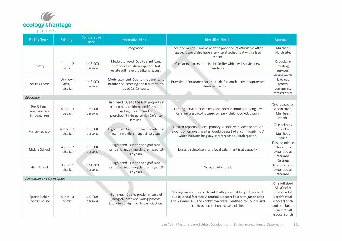
Lee Point Master-planned Urban Development – Environmental Impact Statement 181
Facility Type Existing Comparative
Rate Normative Need Identified Need Approach
integration. included multiple rooms and the provision of affordable office space. It could also have a service attached to it with a lead
tenant.
Muirhead North site.
Library 1 local, 2 district
1:18,000 persons
Moderate need. Due to significant number of children expected but estate will have broadband access
Casuarina library is a district facility which will service new residents.
Capacity in existing services.
Youth Centre Unknown
local, 3 district
1:18,000 persons
Moderate need. Due to the significant number of incoming and future youth
aged 13-18 years.
Provision of outdoor space suitable for youth activities/program identified by Council.
Service model is to use general
community infrastructure.
Education
Pre-School, Long Day Care, Kindergarten
4 local, 3 district
1:8,000 persons
High need. Due to the high proportion of incoming children aged 0-4 years
and significant need of preschool/kindergarten by Defence
families.
Existing services at capacity and need identified for long day care an/preschool focused on early childhood education.
One located on school site at
Muirhead North.
Primary School 6 local, 11
district 1:3,500 persons
High need. Due to the high number of incoming children aged 5-12 years.
Limited capacity at local primary schools with some space for expansion on existing sites. Could be part of a ‘community hub’
which includes long day care/preschool/kindergarten.
One primary School at Muirhead
North
Middle School 4 local, 2 district
1:9,000 persons
High need. Due to the significant number of incoming children aged 13-
17 years. Existing school servicing local catchment is at capacity.
Existing middle school to be expanded as
required.
High School 3 local, 1 district
1:14,000 persons
High need. Due to the significant number of incoming children aged 13-
17 years. No need identified.
Existing facilities to be expanded as
required.
Recreation and Open Space
Sports Field / Sports Ground
5 local, 3 district
1:7,000 persons
High need. Due to predominance of young children and young parents.
Likely to be high sports participation.
Strong demand for sports field with potential for joint use with public school facilities. A football (soccer) field with junior pitch and a shared AFL and cricket oval were identified by Council and
could be located on the school site.
One full sized AFL/Cricket
oval, one full sized football (soccer) pitch and one junior
size football (soccer) pitch

Lee Point Master-planned Urban Development – Environmental Impact Statement 182
Facility Type Existing Comparative
Rate Normative Need Identified Need Approach
integrated within school
and recreation area at
Muirhead North
Aquatic Centre 1 local, 1 district
1:27,000 persons
Low need due to existing pool at Casuarina
No need identified at a local level; however, Council is currently assessing the future of Casuarina Pool and this may create
demand for a future district leisure centre.
Not required for local needs.
Indoor Recreation
Centre 2 district
1:11,000 persons
Low need No need identified at a local level. Opportunity exists to develop
covered playground areas and indoor spaces for recreation at community centre or other indoor spaces.
Not required for local needs.
Outdoor Sports Courts e.g.
tennis, netball
1 local, 3 district
1:18:000 persons
High need. Due to predominance of young children and young parents.
Likely to be high sports participation.
Opportunity for parks to provide more activities for youth e.g. half basketball court. Tennis and netball courts were identified
and could be located on school site with community access.
One or two tennis courts.
One or two netball courts.
Playground/Play space
2 local, 1 district
1:18,000 persons
High need. Due to the high proportion of incoming children aged 0-12 years.
Need identified by government agencies for local playgrounds Opportunity exists to develop covered playground areas and indoor spaces for recreation at community centre or other
indoor spaces.
Provided in accordance
with NT Planning Scheme
Local Park 5 local, 3 district
1:7,000 persons
High need. Due to the high proportion of incoming children aged 0-12 years.
Need identified from government agencies for local parks.
Provided in accordance
with NT Planning Scheme
Neighbourhood Park
30 local, 20-30 district
1:2,000 persons
High need Due to predominance of young children and young parents.
Likely to be active and require outdoor activities.
Need identified from government agencies for a range of open spaces of varying size.
Provided in accordance
with NT Planning Scheme
District Park 5-10 local, 5-
10 district 1:5,500 persons
Moderate need. Due to predominance of young children and young parents.
Likely to be active and require outdoor activities. However close to other
district parks and beach.
No need identified Not required
for local needs
Shopping
Neighbourhood Moderate need. Large incoming There is agreement amongst agencies about the need for local Appropriately

Lee Point Master-planned Urban Development – Environmental Impact Statement 183
Facility Type Existing Comparative
Rate Normative Need Identified Need Approach
Shops population of 6,000. Residents with need for local shops but Casuarina centre and others located within
driving distance.
shops particularly on major transport routes and within walking distance.
zoned and serviced land
for local supermarket, café and local
speciality shops on the project
site.

Lee Point Master-planned Urban Development – Environmental Impact Statement 184
8.5.3 Economic and workforce considerations
8.5.3.1 Economic demographics
The 2014 release of the NT Population Projections for the Greater Darwin region (comprising Darwin City
and the suburbs of Palmerston and Litchfield) identifies that the population of Greater Darwin is expected to
increase to 172,271 persons by 2026. In 2011, the Census measured a total population of the Greater
Darwin region of 129,106. The 2014 estimates increased this existing population to 140,386. In order to
provide for this population, and based on current occupancy rates in the Greater Darwin region in 2011 of
2.7 persons per dwelling, an additional 1,066 dwellings will be required each year. The historic rate of
population growth is strong in comparison to other cities and Australia as a whole, and future projections
anticipate the rate of growth to average 2.1 percent per annum to 2016, before slowing to 1.8 percent per
annum to 2026.
The requirement for an additional 1,066 dwellings per year aligns with the forecast short-term (i.e. 5 year)
requirement for 5,700 dwellings per the Darwin Regional Land Use Plan (DRLUP). The difference is likely due
to the DRLUP accounting for any existing shortfall as well as housing to accommodate growth. The DRLUP
anticipates the location of these dwellings as per Table 63 below. Development of the project site is
considered as part of the greenfield development in the Darwin Northern Suburbs.
Table 63. Darwin Regional Land Use Plan (2014)
GREENFIELD 5.0 DWELLINGS
Darwin Northern Suburbs 680
Palmerston and Litchfield 2,220
Sub-total 2,900
INFILL 6.0 DWELLINGS
Darwin CBD 930
Darwin Inner Suburbs 800
Darwin Northern Suburbs 360
Palmerston and Litchfield 770
Sub-total 2,800
TOTAL 5,700
Greenfield Development in Darwin’s Northern Suburbs aligns with the remaining development in Muirhead
and the first 3-4 stages of the development at the project site that is likely to occur within the short term.
The above confirms the importance of residential development within the Lee Point area, in addition to infill
areas (for example Berrimah Farm) and greenfield areas (including Palmerston East) to meet the projected
short term housing demands.
The 2013-14 mid-year economic report by the NT Treasury states that in 2012-13, the NT economy grew by
5.6 percent, the highest level of economic growth of all States and Territories and well above the national
economic growth rate of 2.6 percent.
The report states:
“The strengthening economy was mainly driven by business investment, reflecting construction work on major
projects, robust household consumption growth and improvement in the Territory’s goods trade surplus.

Lee Point Master-planned Urban Development – Environmental Impact Statement 185
The outlook for economic growth to remain buoyant at 5 percent in 2013-14, increasing to 7 percent in 2014-15,
driven by higher levels of construction activity and household consumption that will more than offset the forecast
contraction of public expenditure.
Economic growth is expected to slow in 2015-16 and 2016-17 as construction activity related to INPEX and Total joint
venture Ichthys project passes its peak.
As the Ichthys project moves from the construction to the production phase, the export sector is forecast to underpin
Territory economic growth from 2016-17… A strengthening in local economic conditions is expected to flow through to
stronger growth in population and employment. The Territory’s rising population is expected to be driven by increased
direct workface requirements of major projects and indirectly due to increasing levels of economic activity. From 2015-
16 onwards, employment is forecast to moderate reflecting the transition of the Ichthys project to the less labour-
intensive production phase.7” (Northern Territory Government 2013, P2).
Although both population and economic projections are forecast to somewhat moderate following the
completion of the construction periods of major projects in the region, overall population growth and
housing demand is expected to continue. The recent focus on Developing Northern Australia
(Commonwealth of Australia 2015) provides confidence of future investment and focus in utilising the
strengths and advantages within the region, particularly the region’s proximity to Asia for trade and defence
purposes.
Domain (2016) reports that the median house price in Darwin in the 12 months to September 2016 is
$587,000, identifying that despite an easing of property prices in the last 24 months, Darwin remains one of
the most expensive cities to buy property. The proposed development of the project site is likely to improve
housing affordability both through an increase in supply and the provision of alternative housing options in
addition to more traditional options prevalent throughout the northern suburbs. Any improvement in
housing availability must occur in a location with an appropriate level of access to existing community health
facilities and regional centres, as well as the provision of neighbourhood-level community, commercial and
open space facilities equal to the increased demands of the locality.
A search of real estate marketing websites identified 195 detached dwellings (realestate.com.au 2016)
available for sale within the northern suburbs west of Rapid Creek, with 58 apartments/townhouses
(realestate.com.au 2016) available for sale. Within the same area, a total of 114 detached dwellings were
available to rent, with 70 apartments/townhouses available (realestate.com.au 2016). SQM Research (2016)
identifies Darwin Vacancy rates at 3.1% in September 2016, slightly up from August 2016 (3.0%) and
relatively steady (slight decrease) compared with the vacancy rate in September 2015 (3.3%). The Darwin
vacancy rates are slightly higher than the national capital city average of 2.4% for the same period. The same
report identifies a price reduction in rental asking prices in the last 12 months to September 2016, with a
reduction of 4.8% for houses and 3.5% for units. The report concludes that “rents remain under pressure in
Darwin too as the mining downturn weighs on demand”. Prior to June 2016, vacancy rates were recorded by
SQM Research (2016) around 4%, indicating a tightening of vacancy rates and indicative of a cyclical event
over the last three years (Australian Broadcasting Corporation 2016).
Labour force participation in Lyons was notably above that for Greater Darwin, at 76.6% compared with
68.7%. Likewise, full youth engagement in either work or study was well above the regional average, at

Lee Point Master-planned Urban Development – Environmental Impact Statement 186
83.6% compared with 69.6% for Greater Darwin. Median income is $64,868 compared with $87,617 for
Greater Darwin.
8.5.3.2 Project Costs and Revenue
Based on the anticipated development outcomes in Section 8.5.1.1, the Lee Point Master-planned Urban
Development is anticipated to provide between 740 to 760 residential lots, apartment blocks and lots for
community and commercial development. With an average subdivision construction cost equivalent to
$125,000 per eventual dwelling, overall construction cost is likely to be in the region of $125 million. Of this,
10% ($12.5 million), is likely to consist of consultant and design fees, with the remainder comprising
construction and works. In context, the development of the Zuccoli Aspire estate comprises 408 lots, whilst
the Zuccoli Village is 830 lots. The Northcrest residential development at Berrimah Farm has just been
granted development approval for stage 1 (144 lots), with 2,000 lots anticipated upon completion. With the
exception of Northcrest, which is likely to attract significant headworks upgrades, construction costs for the
comparable Palmerston East projects are likely to be comparable to those for the Lee Point Master-planned
Urban Development project. The proposed Noonamah Ridge rural residential project anticipates more than
4,000 lots upon completion, albeit at rural densities.
In addition to design and construction costs applicable to the project, there will be costs associated with
external infrastructure upgrades, headworks, application fees and capital work (Table 64). With an
anticipated average lot sale price equivalent to $350,000 per eventual dwelling, the Lee Point Urban
Development is expected to add approximately $350 million to the Northern Territory Economy.
Construction is expected to commence mid-2018, with completion in consistent staging over the course of
7-8 years, thus allowing for approximately 140-150 dwellings per year. Accordingly, the project is expected
to contribute to the Northern Territory economy and provide employment benefits in the short to medium
term.
Table 64. Capital expenditure costs associated with the Lee Point Master-planned Urban Development project
Trunk Water Main
Environmental $10,000
General Requirements $125,000
Water main excavation and backfill $780,000
Pressure main construction $1,365,000
Total $2,280,000
7.0 UPSTREAM AND DOWNSTRAM CAPITAL WORKS
DCP COD cost Lee Point Rd $1,543,000
DCP PWC pressure booster $1,200,000
DCP PWC Sewer pump station $300,000
PWC HV $1,400,000
Total $4,443,000
8.0 HEADWORKS COST – EXTERNAL
DCP COD cost Lee Point Road/MHN $1,236,175
DCP PWC sewer pump station MHN $200,000
Total $1,436,175
9.0 LOCAL AUTHORITY COSTS EXTERNAL – PROJECT SITE
Planning application fees $21,868
COD application fees $462,915
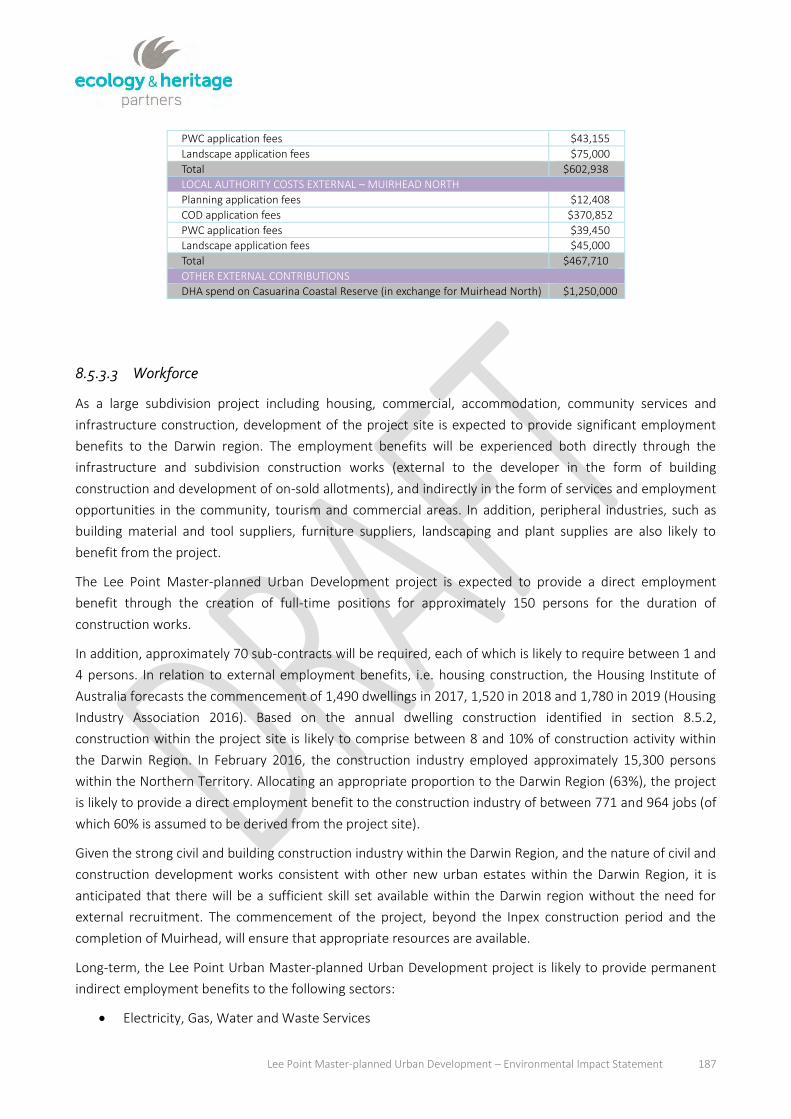
Lee Point Master-planned Urban Development – Environmental Impact Statement 187
8.5.3.3 Workforce
As a large subdivision project including housing, commercial, accommodation, community services and
infrastructure construction, development of the project site is expected to provide significant employment
benefits to the Darwin region. The employment benefits will be experienced both directly through the
infrastructure and subdivision construction works (external to the developer in the form of building
construction and development of on-sold allotments), and indirectly in the form of services and employment
opportunities in the community, tourism and commercial areas. In addition, peripheral industries, such as
building material and tool suppliers, furniture suppliers, landscaping and plant supplies are also likely to
benefit from the project.
The Lee Point Master-planned Urban Development project is expected to provide a direct employment
benefit through the creation of full-time positions for approximately 150 persons for the duration of
construction works.
In addition, approximately 70 sub-contracts will be required, each of which is likely to require between 1 and
4 persons. In relation to external employment benefits, i.e. housing construction, the Housing Institute of
Australia forecasts the commencement of 1,490 dwellings in 2017, 1,520 in 2018 and 1,780 in 2019 (Housing
Industry Association 2016). Based on the annual dwelling construction identified in section 8.5.2,
construction within the project site is likely to comprise between 8 and 10% of construction activity within
the Darwin Region. In February 2016, the construction industry employed approximately 15,300 persons
within the Northern Territory. Allocating an appropriate proportion to the Darwin Region (63%), the project
is likely to provide a direct employment benefit to the construction industry of between 771 and 964 jobs (of
which 60% is assumed to be derived from the project site).
Given the strong civil and building construction industry within the Darwin Region, and the nature of civil and
construction development works consistent with other new urban estates within the Darwin Region, it is
anticipated that there will be a sufficient skill set available within the Darwin region without the need for
external recruitment. The commencement of the project, beyond the Inpex construction period and the
completion of Muirhead, will ensure that appropriate resources are available.
Long-term, the Lee Point Urban Master-planned Urban Development project is likely to provide permanent
indirect employment benefits to the following sectors:
Electricity, Gas, Water and Waste Services
PWC application fees $43,155
Landscape application fees $75,000
Total $602,938
10.0 LOCAL AUTHORITY COSTS EXTERNAL – MUIRHEAD NORTH
Planning application fees $12,408
COD application fees $370,852
PWC application fees $39,450
Landscape application fees $45,000
Total $467,710
11.0 OTHER EXTERNAL CONTRIBUTIONS
DHA spend on Casuarina Coastal Reserve (in exchange for Muirhead North) $1,250,000

Lee Point Master-planned Urban Development – Environmental Impact Statement 188
Retail Trade
Accommodation and Food Services
Information Media and Telecommunications
Financial and Insurance Services
Rental, Hiring and Real Estate Services
Education and Training
Health Care and Social Assistance
Arts and Recreation Services.
The largest indirect employment benefits are likely to be gained by the accommodation and food services
sector (due to the proposed accommodation precinct), and the education and training sector (due to the
proposed primary school).
The accommodation precinct within the project site will provide 1.3% of available short term
accommodation within the Northern Territory, and 5.5% of short term accommodation within the Darwin
Region (Tourism NT 2017). Based on the August 2016 accommodation and food services sector employment
predictions (ABS 2016), the Lee Point Master-planned Urban Development project will provide 117 full and
part time accommodation and food service positions. Education facilities are likely to contribute
approximately 40 full and part time positions. In addition, there are expected to be smaller benefits within
the project to permanent retail, landscape and maintenance, community service and trade employment.
In addition to direct and indirect employment benefits, both the construction process and establishment of
the Lee Point Master-planned Urban Development project is likely to benefit education and training through
the provision of additional apprenticeship, certificate and on-the-job training opportunities. Defence Housing
Australia actively encourage local industry participation and include local input weighting in tender contracts,
with specific requests made for local input and/or local emphasis. The project will also present new small
business opportunities in the hospitality and retail sectors.
Defence Housing Australia has provided a number of education, training and employment benefits to
Indigenous Australians, including the Breezes Muirhead Aboriginal Landscape Education Program (DHA
2016), along with required indigenous participation and training objectives for DHA tender invitation and
expression of interest requests (for example, Expression of Interest for Upgrades and Minor Works to
Defence and DHA Homes – DHA 2013). These initiatives will continue into the development of the project
site, with corresponding benefit to indigenous participation, training, education and employment.
The Breezes Muirhead Aboriginal Landscape Education Program was developed with Greening Australia
Northern Territory, and comprises an indigenous training program with a practical component based around
the Muirhead development site as well as the Greening Australia Native Nursery. This program provides
trainees a rare opportunity to gain hands on experience in a commercial setting, emphasizing the need for
quality and efficiency in production and task performance. During the Muirhead development, the program
saw over 49 entrants, 70% rate of progress to further employment/education, and 67% of participants
achieving a Certificate 1 in Horticulture.

Lee Point Master-planned Urban Development – Environmental Impact Statement 189
8.5.3.4 Commercial Development
A retail analysis for the Lee Point Urban Development project and locality prepared by Deepend Services in
July 2014, reviewed the likely demand and locational aspects of retail floor space within the new
development, particularly in the context of the planned retail space adjacent to Lee Point Road in the
Muirhead subdivision.
The report concluded that likely retail demand would be limited to convenience shopping facilities and
services in the vicinity of 400m2 combined convenience retail floor space, in order to complement the
recently approved floor space of the Muirhead Centre. This floor space is in addition to more tourism or
recreation-based retail, such as restaurants and cafes to be located within the project site.
Accordingly the main street is anticipated to accommodate a vibrant mix of retail servicing the local (and
broader) community, along with occupants of accommodation facilities, with convenience shopping to
complement the expanded (once development occurs) Muirhead Centre.
The location of the land set aside for the Muirhead Centre, more central to surrounding Lyons and Muirhead
populations, will better facilitate larger convenience shopping facilities. As recommended, retail areas within
the project site are provided in close proximity to the community precinct, with appropriate urban design
opportunities available to maximise accessibility and pedestrian traffic between the two.
In addition to accommodation, commercial and recreation-based retail development, development of the
project site is expected to take advantage of the ability to combine residential and non-residential
opportunities in accordance with Zone C (Commercial) of the Northern Territory Planning Scheme, including
medium-high density residential uses above ground level. Varied building heights along the main street, from
4, to 8 to 12 storeys, along with the setback requirements for residential buildings within the Northern
Territory Planning Scheme, will prevent overbearing built form and ensure the appropriate transition of scale
to urban residential areas. Mixed use development incorporating residential areas will extend the vibrancy
and viability of the neighbourhood centre beyond daylight hours and outside of the peak tourist season, and
increase opportunities for a range of housing options to be collocated with goods and services.
8.5.3.5 Tourism Development
In September 2013 the Northern Territory Government established targets for growth in the tourism sector,
and identified a demand for an additional 1,660 accommodation rooms to 2020, with current trends
suggesting a demand ratio for additional accommodation rooms in the CBD equal to 75% of total demand
(Tourism NT 2013). Accordingly, it is anticipated the tourist commercial area will accommodate 150-200
accommodation rooms initially, increasing to 300 rooms over time. The Tourism NT Profile for the year
ending 2015 indicates a total of 766,000 visitors to the Northern Territory during 2015, a small (less than
0.2%) growth from 2014. Visitors equated to a total of 6.693 million visitor nights during 2015.
Tourism NT also reports an average Darwin accommodation occupancy rate of 68% for year ending June
2016, a reduction from previous years due to the combination of a softening tourism market and increased
accommodation supply. Adopting a conservative estimate for the purpose of determining likely visitor
numbers as part of the social impact assessment, a higher rate approaching 2013 highs of roughly 80%
occupancy has been taken in this instance. With up to 200 rooms initially, the tourism precinct within the

Lee Point Master-planned Urban Development – Environmental Impact Statement 190
project site could accommodate some 58,400 visitor nights per year, increasing to 87,600 over time (based
on an anticipated provision of up to 300 rooms).
8.5.3.6 Affordable Housing
Housing affordability has become a critical issue for Darwin accommodation. Although affordability issues
have subsided with the easing of the Darwin housing market and a reduction in property prices and rents, a
forecast steadying of the housing market and anticipated growth into 2017 and 2018 suggests that the
provision of affordable housing options will continue to be critical in ensuring equitable accommodation
levels across all sectors of the community.
The Lee Point Master-planned Urban Development project will provide a mix of 1/3rd Defence Housing
rentals with the remaining properties released to the private owner/occupier and rental market. Defence
Housing Australia provides significant rent subsidies to Defence personnel, with housing types provided
based on intended occupant types (e.g. singles, couples or families).
The range of dwelling density rates identified in the Lee Point Area Plan will ensure a range of dwelling types
and lot sizes are available at a range of prices, with apartments, townhouses and smaller residential lots
more affordable than the larger SD and rural residential (>4,000m2) lots. The inclusion of single dwelling lots
(in accordance with NT Planning Scheme Zone SD), small lot residential development and townhouses (Zone
MD), medium and medium-high density apartments (in accordance with Zones MR and HR) will ensure a
range of detached, attached and apartment dwellings
8.5.3.7 Visual and Social Amenity
In addition to active social and community infrastructure, the project site will provide a number of passive
social and amenity features available to residents and workers within the project, as well as benefitting the
general public. Part 5 of the Northern Territory Planning Scheme provides minimum requirements for the
provision of public open space within residential subdivisions, and includes design criteria regarding the form
and useability of open space. The City of Darwin’s Subdivision and Development Guidelines provide further
detail on the internal design, servicing and provision of exercise and play equipment, as well as the provision
of shared pedestrian and cycle paths and the achievement of full pedestrian connectivity throughout urban
areas. The subdivision and development guidelines also cover the provision of street and open space
lighting, landscaping of verge areas and disabled access. The design of subdivision works in accordance with
both the Planning Scheme and the Subdivision and Development Guidelines will ensure the appropriate
provision of community infrastructure.
No formal access currently exists from Lee Point Road between the area immediately north of the project
site and the walking cycling paths from Rocklands Drive. Whilst there are a number of informal walking and
cycling paths to the rear and through the hospital, and from the northern section of Lyons, the development
of the project site will include a new access to the Casuarina Coastal Reserve, coinciding with the western
end of the main street precinct.
Access will be designed in a manner that minimises disturbance to the escarpment, sand dunes, and
migratory shorebirds (see Section 7.3.1) and provides a benefit not only to residents and visitors to the Lee

Lee Point Master-planned Urban Development – Environmental Impact Statement 191
Point area, but also to residents of Lyons and Muirhead, and members of the public whose primary purpose
in visiting the area is utilising other facilities (for example Lee Point, the Buffalo Creek Boat Ramp and the
caravan park).
Residential development within the subject land will supplement the availability of housing within Darwin’s
northern suburbs, and increase housing options through innovative and varied dwelling design techniques.
The provision of climatically appropriate and distinctive row housing, units, townhouses and apartments,
along with alternative infrastructure and street connection opportunities, such as rear-lot vehicle access, will
have a corresponding benefit on neighbourhood amenity. Defence Housing Australia’s commitment to
climate responsive design is evident by the design covenants in the Breezes Muirhead estate, with a focus on
small lot housing with a corresponding reduction in energy consumption (Safarova 2016). This innovative
approach to environmentally sensitive housing has been recognised by the industry with a number of
awards, including:
2016 Urban Development Institute of Australia (UDIA) Northern Territory Award for Environmental
Excellence
2016 UDIA Northern Territory Awards for Innovation in Design
2015 UDIA Northern Territory Award for Excellence in Masterplanned Development
2015 UDIA Northern Territory Award for Excellence for Environmentally Sustainable Development.
It is expected that a similar approach will be adopted for the Lee Point Master-planned Urban Development
project.
Development of the project site comprises a large residential subdivision and urban development over a
period of 7-8 years. As such, the existing landform will be altered due to the clearing of vegetation,
earthworks and drainage works, construction works comprising the installation of and upgrade to service
infrastructure, landscaping and built form construction. Landform alteration to the extent proposed will alter
the nature and character of the locality, and has the potential to affect public amenity (i.e. visual, sound and
traffic) during construction.
The extent of amenity impacts during the construction period will be subject to the management and
phasing of construction activities, and the layout, design and implementation process.
Defence Housing Australia has identified the potential for critical amenity impacts and determined
appropriate management responses. Specific measures incorporated into the design and construction
process will minimise amenity impacts, both visual and otherwise, including:
Adherance to the built form requirements of the Northern Territory Planning Scheme, including the
Lee Point Area Plan, which seeks to limit densities adjacent to existing residential areas in the north
of Lyons and Muirhead, with increasing density and building height towards the centre of the project
site. The NT Planning Scheme includes design principles relating to urban and streetscape design,
protection of heritage and conservation areas, landscaping and public open space.
Monetary and land contribution to the Casuarina Coastal Reserve, securing a formal buffer between
the existing coastal reserve and the extent of urban development.

Lee Point Master-planned Urban Development – Environmental Impact Statement 192
Construction Environment Management Plan to detail construction management, including erosion
and sediment control, dust control, noise, hours of operation and construction traffic. The
management plan will ensure all construction regulations provided by the Northern Territory EPA
are adhered to, and amenity impacts from construction activities are minimised. The preparation,
approval and adherence to a detailed CEMP will be required as a condition of the subdivision
development permit issued by the Development Consent Authority, and must be approved and
implemented prior to the commencement of any works on site.
The determination of all traffic impacts and the capacity of the road network to accommodate
increased vehicle movements through detailed traffic impact analysis. Provision of developer
contributions to facilitate road upgrades as required.

Lee Point Master-planned Urban Development – Environmental Impact Statement 193
8.6 Risk Assessment
8.6.1 Risk assessment summary
The identification of social and economic risks during the site preparation, construction and occupation
phases of the project site are identified in the risk assessment (Appendix C). The risk assessment identifies
parties responsible for potential risks as well as possible affected parties.
The table below presents a summary of the medium to high level risks that could potentially arise through
the proposed development of the project site. It also includes the recommended management responses to
ensure the project has no negative impact on the local and regional community either socially or
economically. The full results of the risk assessment are provided in Appendix C which includes a list all risks
identified, as well as a description of expected positive outcomes from the project.

Lee Point Master-planned Urban Development – Environmental Impact Statement 194
Table 65. Risk assessment summary for the project site
Impact Phase Stakeholders
Type of potential impact (positive or negative)
Probability (high, medium or low)
Consequence (high, medium or low)
Management and/or mitigation strategies
Responsible Parties
Timeframe KPI
Housing and Accommodation
Oversupply of housing, impact
on housing market
Residential stage
completion and commencemen
t of sales and marketing.
DHA
Housing market vendors
Negative Medium High
Align staging and
development with growth
rates per Darwin
Regional Land Use Plan (or
updated policies and projections)
DHA
Duration of construction
and initial sales (<10 years)
Maintenance and/or growth of pricing and consistency of
sales.
Workforce
Inadequate suitably trained persons within
the Darwin Region to
supply skills.
Construction
Construction Industry
DHA.
Negative although solutions
comprising additional training/
education opportunities potentially
positive.
Low Medium
Provision of appropriate
training opportunities
for local market.
Importation of skills as a last
resort.
DHA. Duration of
construction.
Minimum local input
achievement.
Shortfall of skilled workers elsewhere due to construction
works at Lee
Construction
Construction Industry
DHA.
Negative although solutions
comprising additional
Low (primarily due to
commencement of the project
post-Inpex
Medium-high
Ensure staging and timing of construction aligns with anticipated
DHA (Responsible
for management
strategy in
Duration of construction.
No unreasonable
effect on access to trades /
construction

Lee Point Master-planned Urban Development – Environmental Impact Statement 195
Impact Phase Stakeholders
Type of potential impact (positive or negative)
Probability (high, medium or low)
Consequence (high, medium or low)
Management and/or mitigation strategies
Responsible Parties
Timeframe KPI
Point training / education
opportunities potentially
positive.
construction) population and housing growth
rates for the Darwin Region
previous column)
services.
Shortage of workers to
provide services in
community, commercial
and accommodatio
n facilities
Occupation and ongoing
Northern Territory
Government
Public and private
education sector
Private service
providers and
commercial operators
DHA
Negative
Low (range of skilled,
unskilled, vocational and
training opportunities
avoids a concentrated demand for
specific skills)
Medium
Development in accordance
with projected commercial,
accommodation and social
infrastructure demand based on population projections, to ensure service
provision doesn’t exceed
demand created by population.
DHA
Northern Territory
Government
Design and Construction
Establishment and continued operation of
non-residential services and
facilities.
Social Infrastructure
Increase use of Buffalo Creek Boat Ramp.
Occupation
Northern Territory Government.
Negative Low Medium
Ramp has recently been upgraded and access is limited by tidal movement. Continual monitoring required upon
Northern Territory Government.
Upon occupation of development and ongoing.
Ramp waiting times and congestion are within normal ranges.

Lee Point Master-planned Urban Development – Environmental Impact Statement 196
Impact Phase Stakeholders
Type of potential impact (positive or negative)
Probability (high, medium or low)
Consequence (high, medium or low)
Management and/or mitigation strategies
Responsible Parties
Timeframe KPI
occupation to determine impact on use patterns.
Increase visitation to Casuarina Coastal Reserve
Occupation
Northern Territory Parks and Wildlife
DHA
Negative High High
Monetary and spatial (land) contributions by DHA to increase size and improve visitor facilities within the reserve.
DHA (contribution)
Northern Territory Parks and Wildlife (monitoring)
Completion of Construction.
Achievement of appropriate access to facilities for all users. Achievement of relevant objectives of CCR Management Plan.
Shortfall of social services
Occupation
DHA
Residents and general public
Negative Medium High
Ensure adequate serviced land is available for community and social infrastructure in accordance with needs analysis.
DHA (land)
Northern Territory Government / Private Sector (infrastructure).
Commencement of occupation and ongoing.
Achievement of Lead Practice Principles and Benchmarks per social needs analysis.
Increase traffic impacts – Lee point Road
Construction and occupation
DHA
All road users.
Negative High Medium
Undertake road upgrades in accordance with Traffic Impact Assessment
DHA
City of Darwin
Construction and ongoing
Road operates within capacity

Lee Point Master-planned Urban Development – Environmental Impact Statement 197
Impact Phase Stakeholders
Type of potential impact (positive or negative)
Probability (high, medium or low)
Consequence (high, medium or low)
Management and/or mitigation strategies
Responsible Parties
Timeframe KPI
Amenity and Safety
Adverse amenity
impacts during construction
Site preparation
and construction
DHA
Lyons / Muirhead Residents
and General public
Royal Darwin Hospital
Negative Medium High
All construction and
development works in
accordance with a detailed Construction Environment Management Plan (CEMP).
Establishment of a complaints
register to monitor and respond to complaints
DHA
Subcontractors. Construction
No complaints received. Any
complaints are promptly resolved.
Adverse amenity
impacts from modified
landform / built form
Construction and occupation
DHA
Lyons / Muirhead Residents
and General public
Royal Darwin Hospital
Negative Low Medium
Ensure appropriate compliance
with design and layout
requirements of NT Planning
Scheme, including
minimum lot sizes, setbacks,
building heights,
landscaping and open
DHA. DCA. City of Darwin
Construction and ongoing
(maintenance)
Issue of Development
Permit. Positive public reception
of project.

Lee Point Master-planned Urban Development – Environmental Impact Statement 198
Impact Phase Stakeholders
Type of potential impact (positive or negative)
Probability (high, medium or low)
Consequence (high, medium or low)
Management and/or mitigation strategies
Responsible Parties
Timeframe KPI
space, to ensure visual
amenity is maximised.
Economic / Business Development
Low / slow take-up of commercial land by private sector
Marketing and occupation
DHA
Retail and hospitality sector.
Negative Low Medium
Ensure the appropriate provision of serviced commercial land, designed and located to cater for end use. Provide commercial land in accordance with needs analysis (ie avoid over supply)
DHA Design, construction and marketing
Consistent take-up of commercial land.
Impact on viability of nearby commercial areas by proposed centre facilities
Occupation
DHA
Retail and hospitality sector.
Negative Low-medium Medium-high
Provide commercial land in accordance with needs analysis (ie avoid over supply), which considers the current and
DHA Design, construction and ongoing
No discernible effect on nearby centres. Consistent take-up of commercial land within Lee Point (suggesting strong demand)

Lee Point Master-planned Urban Development – Environmental Impact Statement 199
Impact Phase Stakeholders
Type of potential impact (positive or negative)
Probability (high, medium or low)
Consequence (high, medium or low)
Management and/or mitigation strategies
Responsible Parties
Timeframe KPI
future provision of commercial and centre-type facilities (including the planned Muirhead centre)
Over-supply of commercial land
Occupation
DHA
Retail and hospitality sector
Negative Low-medium Medium-high
Provide commercial land in accordance with needs analysis. Update needs analysis and consult with retail sector during subdivision design. Provide accommodation in accordance with tourist accommodation demand analysis.
DHA. Northern Territory Government (confirm demand for tourist accommodation land)
Design, construction and marketing
Consistent take-up of commercial land. Progression of development concepts to construction.
Commercial land remains vacant after sale
Completion of construction, occupation and ongoing
DHA
Commercial land purchasers
Negative Medium Medium
Contractual provisions regarding commencement of
DHA Sales / Marketing and occupation
Commencement, progression and completion of lot development

Lee Point Master-planned Urban Development – Environmental Impact Statement 200
Impact Phase Stakeholders
Type of potential impact (positive or negative)
Probability (high, medium or low)
Consequence (high, medium or low)
Management and/or mitigation strategies
Responsible Parties
Timeframe KPI
construction (ie within specified time after settlement)

Lee Point Master-planned Urban Development – Environmental Impact Statement 201
8.6.2 Description of impacts and mitigation
Providing the following considerations are adopted, future residents and visitors will have appropriate access
to social infrastructure, and the project will provide an appropriate economic and social benefit at both a
local and regional scale:
Provide a range of lot sizes and housing types to ensure availability of housing across different
market sectors.
Provide public open space which, at a minimum, achieves the minimum requirements of the
Northern Territory Planning Scheme.
Provide land for commercial development, appropriately integrated with recreation and tourism-
focussed activities which, at a minimum, facilitates a convenience store and opportunity for the
establishment of a general practice medical clinic, with provision to be led by the private sector.
Ensure commercial development does not compromise the hierarchy of centres in the northern
suburbs, and more specifically does not compromise the role and function of the commercial centre
in Muirhead.
In addition, the social and economic impacts associated with developing the project site assume the
provision of community services in the adjoining Muirhead North site as outlined in the Lee Point Master-
planned Urban Development plan, including:
Approximately 3.5 hectare site for the purpose of an integrated primary school, kindergarten and
long day care facility.
At least one childcare centre for approximately 60 children.
Community centre (likely to be owned and operated by the City of Darwin).
Integrated formal recreation complex, collocated with primary school site, comprising sport fields
and courts.
The proposed development of the project site is also expected to have a number of positive social and
economic impacts including:
Housing affordability
Integrated residential, community and commercial uses
Employment opportunities
Access to commercial services and facilities
Access to Casuarina Coastal Reserve and Casuarina Beach
Increased public open space and recreational facilities.
To ensure the social and economic benefits of the project are realised, and that the proposed mitigation and
management strategies meet the community and Government’s expectation, a stakeholder engagement

Lee Point Master-planned Urban Development – Environmental Impact Statement 202
strategy will be implemented (Table 66). There will also be ongoing monitoring of the projects’ performance
against social and economic Key Performance Indicators (KPIs) as detailed in the CEMP (Appendix D).
Defence Housing Australia will adopt an existing organisational dispute resolution policy to outline an active
response to community and stakeholder concerns regarding potential social impacts. As a general rule, all
concerns, whether from a community group or member, or from a stakeholder/approval agency, will be
addressed promptly and a written response provided thereto. A written record or all relevant
complaints/issues, action taken and the response provided will be kept by DHA. Identified responses include
(but are not limited to):
Written response to all written submissions received as part of the statutory exhibition process for
the development application.
Transcription of all verbal/written concerns/complaints raised at community meetings, including
contact details where provided, and written response thereto.
Ensure written agreements follow any verbal agreements in relation to development undertakings,
agreements and conditions, and continued engagement with relevant stakeholders regarding
agreement conditions.
Implementation of grievance procedure policy for receiving, actioning and responding to
complaints/concerns during construction.
The dispute resolution policy will provide pathways and processes for handling grievances, outline
procedural steps, measures for the keeping of grievance logs, data evidence of dialogue and communication
processes, substantive outcomes achieved and measures for implementing outcomes into wider policy.

Lee Point Master-planned Urban Development – Environmental Impact Statement 203
Table 66. Stakeholder Engagement Strategy
Key Stakeholders Stakeholder Interest Engagement Actions Steps to ensure
implementation Review Mechanisms
City of Darwin
Agency responsible for local roads and associated infrastructure, stormwater drainage and associated infrastructure, public open space (at a local level) and some community facilities.
Pre-design and application meetings, including presentation to full Council.
Legislative consultation during development application process.
Formal application to Council for design approval.
Council to formally approval detail design.
Ongoing review during Council meetings and review of full Council decision.
Development Consent Authority
Consent authority for development approval.
Pre-application meetings and briefing to the DCA.
Engagement through development application.
Development approval and conditions.
Adverse development application decision.
Northern Territory Parks and Wildlife Commission
Agency responsible for the administration, management and maintenance of the Casuarina Coastal Reserve.
Ongoing meetings and formal agreement with Parks regarding the provision of part of the site into the CCR.
Engagement with Parks regarding CEMP.
Agreement to integrate part of the site into the CCR.
Approval of CEMP.
Ongoing review during meetings.
Northern Territory Power and Water Corporation
Agency responsible for the reticulation of power, water and sewerage infrastructure within the Northern Territory.
Pre-design and application meetings.
Legislative consultation during development application process.
Formal application to PWC for design approval.
Detailed design approval of reticulated infrastructure and services.
Review on advice received in response to development application. Review need for further engagement based on detailed design feedback.
Northern Territory Department of Health
Royal Darwin Hospital and associated facilities. Provide advice regarding development potentially subject to impacts from mosquitoes and biting midges.
Pre-application meetings and advice on progress.
Pre-application meetings with medical entomology unit to finalise land use restrictions on land affected by biting insects.
No objection from the Department of Health to Development application.
Ongoing review during design, approval and construction phase.

Lee Point Master-planned Urban Development – Environmental Impact Statement 204
Key Stakeholders Stakeholder Interest Engagement Actions Steps to ensure
implementation Review Mechanisms
General Public – Adjoining owners / occupants
Development on adjoining / nearby land.
Community consultation sessions pre-lodgement.
Provision of design details pre-lodgement (Development application).
Design and construction undertakings in response to feedback to be enforced by way of development permit conditions.
Review based on initial feedback.
General Public – users of Casuarina Coastal Reserve
Development on nearby / adjoining land. Increased size and facilities within Casuarina Coastal Reserve.
Community information provided via general community media.
DHA contact provided.
Design and construction undertakings (including agreed DHA upgrades / contributions to CCR) in response to feedback to be enforced by way of development permit conditions.
Review based on initial feedback.
Northern Territory Department of Education
Owner / operator of future education facility within 09370.
Pre-design and application meetings, including addressing design and servicing requirements of school site.
Legislative consultation during development application process.
Review on advice received in response to development application. Review need for further engagement based on design feedback.
Northern Territory Department of Environment and Natural Resources
Agency responsible for reviewing erosion and sediment control measures, implementation and onsite management.
Pre-design and application meetings, including design input into erosion and sediment control measures.
Legislative consultation during development application process.
No objection from the Department of Education to Development application.
Development of school site by the Department of Education.
Review on advice received in response to development application. Review need for further engagement based on comments received on ESCP application.
Northern Territory Environment Protection Authority
Agency responsible for assessment and approval of the Environmental Impact Statement under the NT Environmental Assessment Act.
Ongoing consultation during EIS.
Legislative consultation during development application process.
Approval of EIS.
Acceptable implementation of EIS conditions.
Engagement to be reviewed subject to EIS feedback, decision and conditions.

Lee Point Master-planned Urban Development – Environmental Impact Statement 205
Key Stakeholders Stakeholder Interest Engagement Actions Steps to ensure
implementation Review Mechanisms
Commonwealth Department of the Environment and Energy
Department responsible for assessment and approval of the Environment Impact Statement under the Commonwealth Environment Protection and Biodiversity Conservation Act 1999
Ongoing consultation during EIS (pre and post lodgement).
Approval of EIS.
Acceptable implementation of EIS conditions.
Engagement to be reviewed subject to EIS feedback, decision and conditions.
General Public - Other
Community groups with a focus on environment and development. Members of the public with an interest in the Lee Point area and/or development generally.
Community information provided via general community media.
DHA contact provided.
Design and construction undertakings in response to feedback to be enforced by way of development permit conditions.
Review based on initial feedback.

Lee Point Master-planned Urban Development – Environmental Impact Statement 206
9 NOISE
9.1 Introduction
This chapter assesses the potential noise and vibration impacts of the project and addresses the following
criteria of the EIS ToR:
The Proponent should address the impact of noise resulting from construction stages of the Project
on nearby residents.
The potential sensitivity of receptors to noise and mitigation measures should be discussed.
A Noise Management Plan should outline methods for communicating with, and reducing the impact
on, residents within the vicinity of the Project who may be adversely affected by the Project.
The chapter is structured in the following manner:
Description of the methods used to model the magnitude of noise and vibration disturbance
emanating from the project site during the construction and operation phase, a description of
benchmarks based in industry guidelines for the acceptable level of disturbance, and the likely
impacts to sensitive receivers including adjoining residents, future residents and future receivers (i.e.
proposed primary school at Muirhead North) (Section 9.2).
A summary of the Identified risks to sensitive receivers and future residents and a list of practical
and appropriate mitigation measures to avoid any unacceptable noise or vibration disturbance that
may occur during the construction or operation phase of the project (see Section 9.3).
The full risk assessment is provided in Appendix C, while most of the findings presented in this chapter are
based on the Noise Impact Assessment prepared by Cardno (2017a, b), which is provided in Appendix H for
2CRU and Appendix for Muirhead North .

Lee Point Master-planned Urban Development – Environmental Impact Statement 207
9.2 Existing conditions and impacts
9.2.1 Method of Assessment
The section describes the methods used to model the disturbance of noise and vibration during the
construction and operation phase of the project. Modelling is based on industry and Australian Standards. As
the type and number of plant and equipment to be utilised during construction has not been confirmed,
assumptions were made based on experience with similar residential projects.
9.2.1.1 Construction Noise
To determine construction noise, a SoundPLAN noise model was prepared and noise levels of typical
construction plant were input into the model. The type and number of plant and equipment was assumed
based upon experience from similar projects and the plant noise data provided in Australian Standard AS
2436:2010, “Acoustics – “Guide to Noise & Vibration Control on Construction, Demolition & Maintenance
Sites”.
The different construction phases for the project have been assumed based on similar previous projects.
The construction phases and assumed sound power levels are outlined below:
Clearing of Vegetation & Site Establishment (LAeq = 121 dB(A) & LAmax = 131 dB(A))
Bulk Earthworks (LAeq = 123 dB(A) & LAmax = 133 dB(A))
Drainage Infrastructure (LAeq = 115 dB(A) & LAmax = 116 dB(A))
Road Surfacing Works (LAeq = 118 dB(A) & LAmax = 130 dB(A))
9.2.1.2 Construction Vibration
Recommended minimum separation distances between sensitive structures and typical vibration generating
plant to minimise the risk of cosmetic damage to structures were identified with reference to standard
expected ground vibration curves for various equipment types and are likely construction areas and
activities.
9.2.1.3 Operational Noise
Road traffic noise was predicted using the 3D noise modelling software SoundPLAN 7.4. SoundPLAN
software applies the algorithm from the Calculation of Road Traffic Noise, UK Department of Transport,
Welsh Office 1988 (CoRTN), which is commonly used for road traffic noise assessment throughout Australia.
The modelling predicts expected road traffic noise impacts based on the following data inputs.
Existing 3D topography of the site, surrounds and nearby road alignments.
Proposed Site topography.
Road traffic flows.
Posted road traffic speeds, and % heavy vehicles.
Pavement surface type

Lee Point Master-planned Urban Development – Environmental Impact Statement 208
General Modelling Methodology
The traffic noise model was used to predict post-development road traffic noise impacts on the dwellings
located within the proposed development in the year 2026. The predicted noise levels were compared to the
relevant noise criteria and exceedances determined.
Recommendations relating to feasible and reasonable mitigation measures were then developed.
The CoRTN assessment methodology was adopted for this assessment. The CoRTN modelling methodology
sets traffic sources at a height of 0.5 metres above the road.
Noise modelling was conducted with and without noise barriers along Lee Point Road for year 2026.
Application of Correction Factors
The following correction factors were applied to the modelling:
Pavement surface corrections of 0 dB(A) for dense graded asphalt (DGAC)
An AustRoads correction factor to convert standard CoRTN outputs to Australian Conditions of -1.7
dB(A) was applied to the modelling results for receivers associated with future buildings.
The standard conversion (referenced from AS 3671) of LA10,18hr = LAeq, day + 3 dB(A) was also applied.
A conversion factor of LAeq, night = LAeq, day - 3 dB(A) was applied to determine night-time traffic noise
levels.
A façade correction factor of + 2.5 dB(A) was applied to modelled receivers to allow for façade
correction once the buildings are located on each Lot.
Noise Modelling Inputs and Assumptions
Table 67 below details the modelling input asumptions used for the noise modelling.
Table 67: Modelling Assumptions
Modelling Element Input/Assumption. Source Reference
Ground Elevation Geometry Provided by Cardno
Proposed Elevation Geometry Provided by Cardno
Road Alignment Provided by Cardno
Site Traffic Flow Data Provided by SMEC & DHA
Road Traffic Speed Provided by Cardno
Road pavement surfaces Assumed to be DGA with no pavement correction factors added.
Ground Absorption 50% over soft ground
Methodology Calculation of Road Traffic Noise, UK Department of Transport, 1988
Weather conditions Calm Conditions
Façade Reflection +2.5 dB(A) – applied to traffic prediction models, for receivers associated
with future buildings.
LA10 and LAeq conversions LAeq,day = LA10,18hr – 3 dB(A)
Day time to night-time conversion LAeq,night = LAeq,day – 3 dB(A)

Lee Point Master-planned Urban Development – Environmental Impact Statement 209
Modelling Element Input/Assumption. Source Reference
AustRoads Correction to CoRTN for Façade Corrected Australian Conditions
-1.7 dB(A) CoRTN correction for Australian conditions (with reference to AustRoads.)
Receiver Height Assumed to be 1.8 and 4.6 metres above ground level.
Traffic Volumes and Posted Speed
Projected traffic volumes for the year 2026 within the project site were obtained from the traffic impact
assessment by SMEC (2015). The traffic impact assessment report projected traffic volumes for year 2025 for
the finished development of the green field sites north of Lions and Muirhead Breezes Estate. For this
assessment it is assumed that traffic volumes for year 2026 is identical to year 2025 as no further
developments are likely to occur and that Lee Point Road is a dead end road north of the project site.
The percentage of heavy vehicles (HV) were stated by SMEC (2015) as 0.0%; however, a 5% HV should be
used as a conservative assumption, which is in line with previous noise impact assessments carried out for
residential developments. Projected traffic volumes and traffic speeds on Lee Point Road, for the noise
modelling is presented in the Table 68 below.
It should be noted that traffic volumes at the southern part of the development are predicted to be
significantly higher than at the northern end of the development as Lee Point Road is a dead end road with
no significant area north of the development suitable for further development.
Table 68. Modelled Traffic Volumes & Speeds
Road Segment
Projected 18 Hour Traffic Volumes on Lee Point Road Between 6am and Midnight (94% of AADT)
% Heavy Vehicles Proposed
Speed
South 8580 5% 60 Km/h
Mid-South 7851 5% 60 Km/h
Mid 5131 5% 60 Km/h
Mid-North 1628 5% 60 Km/h
North 717 5% 60 Km/h
9.2.2 Adopted Noise & Vibration Criteria
9.2.2.1 Construction Noise
To mitigate the risk of excessive construction noise impacting on nearby existing sensitive receivers, noise
management criteria has been adopted for the development referenced from the Northern Territory
Environmental Protection Authority’s Noise Guidelines for Development Sites in the Northern Territory, May
2014. (EPANGDS).
The EPANGDS outlines acceptable construction times and noise levels that should not be exceeded during
those times.
The guideline states that construction activities should be restricted to:
a. between the hours of 7am and 7pm Monday to Saturday; and

Lee Point Master-planned Urban Development – Environmental Impact Statement 210
b. between the hours of 9am and 6pm on a Sunday or public holiday.
The table below outlines the applicable construction noise limits for the project. Derivation of these noise
limits is based on assumed background noise levels in each of these areas, and the methodology outlined in
Appendix and Appendix I.
Table 69. Adopted Construction Noise Limits for the Development
Noise Area
Construction Noise Limit, LAeq,15min Sleep Disturbance from 10pm to 7am, LAmax
Externally Monday to Saturday from 7am
to 7pm Sunday and public holidays
from 9am to 6pm
Residential 50 50 65
Casuarina Coastal
Reserve 50 50 65
Hospital 55 55 65
9.2.2.2 Construction Vibration
The following vibration criteria for human comfort apply to this project.
Table 70. Adopted Continuous Construction Vibration Limits for the Development – Sensitive Receivers
Building Work Period Resultant PPV mm/s
Lower Limit Upper Limit
Dwellings (including hotels and motels)
Standard hours 1 2
Non-Standard hours - evening 0.3 1
Non-Standard hours - night-time
Medical/health buildings (wards, surgeries, operating theatres, consulting
rooms) All
0.3 1
Educational facilities (rooms designated for teaching purposes)
While In Use Court of Law (Court rooms)
Court of Law (Court reporting and transcript areas, Judges’ chambers)
Community buildings (Libraries, places of worship)
While In Use 1 2
Commercial (offices) and retail areas

Lee Point Master-planned Urban Development – Environmental Impact Statement 211
The minimum ‘safe limits’ for continuous construction vibration at low frequencies for commercial and
industrial buildings for the project have been referenced from German Standard DIN 4150.3 as follows Table
71).
Table 71. Adopted Continuous Construction Vibration Limits for the Development – Commercial & Industrial Receivers
Type of Structure Assessment Criteria, mm/s Reference
Dwellings (including hotels and motels)
5 (rms) at 1-10Hz
German Standard DIN 4150 5 to 15 (rms) at 10-50Hz
15 to 20 (rms) at 50-100Hz
Sensitive structures (including heritage listed structures)
3 (rms) at 1-10Hz
German Standard DIN 4150 3 (rms) to 8 at 10-50Hz
8 to 10 (rms) at 50-100Hz
‘Safe limits’ are defined as levels where no visible or cosmetic damage is expected to occur.
The transient construction vibration ‘limits’ to avoid cosmetic damage at low frequencies for different types
of buildings from BS 7385-2, have been adopted for this development as follows (Table 72).
Table 72: Adopted Transient Construction Vibration Limits for the Development – All Receivers
Type of Building Resultant PPV in Frequency Range of Dominant Pulse, mm/s
4 to 15Hz 15Hz and above
Reinforced or framed structures. Industrial and heavy commercial buildings
50 mm/s at 4 Hz and above -
Unreinforced or light framed structure. Residential or light commercial type buildings
15 mm/s at 4 Hz increasing to 20 mm/s at 15 Hz
20 mm/s at 15 Hz increasing to 50 mm/s at 40 Hz and above
Additional noise management measures with respect to construction noise are detailed in Appendix
9.2.2.3 Sleep Disturbance
In the absence of NT specific criteria for sleep disturbance, relevant guidelines from the World Health
Organisation and the QLD EPA EcoAccess Planning for Noise Control Guideline have been applied.
As a rule in planning for short-term or transient noise events, for good sleep over eight hours, the indoor
sound pressure level measured as a maximum instantaneous value should not exceed the noise levels
outlined in
Table 73 within a bedroom.
Table 73. Adopted Sleep Disturbance Noise Limits
Internal Maximum Noise Level LAmax Maximum Number of Noise Events at Night
45 dB(A) 10 to 15

Lee Point Master-planned Urban Development – Environmental Impact Statement 212
Internal Maximum Noise Level LAmax Maximum Number of Noise Events at Night
50 dB(A) up to 3
65 dB(A) 1
9.2.2.4 Operational Noise
With regard to operational noise impacts the following risks apply to the development:
Road traffic noise levels above the recommended noise limit for health and wellbeing.
Road traffic noise levels above the recommended noise limit for sleep disturbance.
Annoyance or awakening from siren of an emergency vehicle.
To manage these risks, potential impacts for operational noise sources associated with the development has
been assessed against the appropriate NT regulations, and mitigation designed accordingly so that noise
emissions and immissions associated with this development can be managed to acceptable levels.
The table below shows the applicable external road traffic noise limits as outlined in the Northern Territory
Government’s Road Traffic Noise on NT Government Controlled Roads.
Table 74. Adopted External Traffic Noise Limits for the Development – Sensitive Receivers
Receiver Description Applicable Road Traffic Noise Limits
Noise descriptor External noise level in dB(A)
Residential, Hotels and Tourist Precincts L10,18hr 63
School, Day Care, Library and Community Building L10,18hr 58
Outdoor Educational and Passive Recreational Areas L10,18hr 58
Hospital, Aged Care Facility and Nursing Home L10,18hr 58
Table 75 below shows the applicable internal noise limits as recommended in AS 2107 Recommended design
sound levels and reverberation times for building interiors.
Table 75. Adopted Internal Traffic Noise Limits for the Development – Sensitive Receivers
Area Recommended Internal Design Sound Objective, Leq, (T), dB(A)
Sleeping Areas (All bedrooms) 30
Living Areas (Lounge rooms within dwellings) 35
Work Areas 35
Apartment common areas 45
9.2.3 Impacts
9.2.3.1 Construction Vibration
The tables below outline the recommended minimum separation distances between sensitive structures and
typical vibration generating plant for development at 2CRU (Table 76) and Muirhead North (Table 77), in

Lee Point Master-planned Urban Development – Environmental Impact Statement 213
order to avoid cosmetic damage to structures. It is based on the expected plant and equipment to be used
for construction, as the equipment to be used during construction is yet to be determined. The table
indicates that cosmetic damage to buildings can be avoided by correct selection of plant when working near
vibration sensitive structures.
Table 76. Recommended minimum separation distances – 2CRU
Receiver Nearest Potential Construction Area
Distance to Nearest Sensitive Structure,
metre
Maximum size of Vibratory Roller
Maximum size of Hydraulic Hammer
Darwin Hospital Project site 175 > 300 kN
> 18 tonnes 1600 kg – 18 to 34t
excavator
Lee Point Village Resort Lee Point Road Traffic
Corridor 15
< 300 kN Typically 7-13 tonnes
900 kg – 12 to 18t excavator
Lyons Estate Project site and Lee Point
Road Traffic Corridor 1.5
< 50 kN Typically 1-2 tonnes
300 kg - 5 to 12t excavator
Current dwellings at Muirhead Breezes Estate (June 2016)
Lee Point Road Traffic Corridor
50 > 300 kN
> 18 tonnes 1600 kg – 18 to 34t
excavator
Potential future dwellings at Muirhead
Breezes Estate
Lee Point Road Traffic Corridor
15 < 300 kN
Typically 7-13 tonnes 900 kg – 12 to 18t
excavator
Table 77. Recommended minimum separation distance - Muirhead North
Receiver Nearest Potential Construction Area
Distance to Nearest Sensitive Structure,
metre
Maximum size of Vibratory Roller
Maximum size of Hydraulic Hammer
The 2CRU Site Muirhead North Site and Lee Point Road Traffic Corridor
1.5 < 50 kN
Typically 1-2 tonnes
300 kg - 5 to 12t excavator
Lee Point Village Resort Muirhead North Site 1.5 < 50 kN
Typically 1-2 tonnes
300 kg - 5 to 12t excavator
Lyons Estate Muirhead North Site and Lee Point Road Traffic Corridor
15 < 300 kN
Typically 7-13 tonnes
900 kg – 12 to 18t excavator
Current dwellings at Muirhead Breezes Estate (June 2016)
Muirhead North Site and Lee Point Road Traffic Corridor
50 > 300 kN
> 18 tonnes
1600 kg – 18 to 34t excavator
Potential future dwellings at Muirhead Breezes Estate
Muirhead North Site and Lee Point Road Traffic Corridor
1.5 < 50 kN
Typically 1-2 tonnes
300 kg - 5 to 12t excavator
9.2.3.2 Predicted Noise Impacts
Construction Noise
Construction noise levels are unlikely to exceed the design benchmark noise limits except for the worst case
scenarios, where work is conducted at the boundary of the development and during upgrade work of Lee

Lee Point Master-planned Urban Development – Environmental Impact Statement 214
Point Road. The exceedances are due to limited separation distance between the site and neighbouring
receivers and the high noise levels typically generated by construction plant. It is worth noting that work
along the boundary of the development will occur for shorty durations only, as clearing of vegetation and
general construction work will move around the development site as work progresses. Furthermore, the
model exceedances assume that all the noisiest items of plant will be operating simultaneously which is
unlikely to occur.
Sleep Disturbance
The most likely source of potential sleep disturbance from the night construction works will be from the use
of pneumatic hammers or saw cutting during services relocation and/ or road pavement works or from truck
movements on site, in particular the application of air brakes.
Maximum noise levels have been predicted to the nearest affected residential receivers to allow a review of
the potential for sleep disturbance from construction activities at night. Noise levels have been calculated
based on a worst case scenario when plant is located at the closest point to each receiver. On this basis, the
predicted results (LAmax) indicate that maximum construction noise levels at the nearest noise sensitive
receivers are likely to exceed the sleep disturbance criteria, when construction works are located nearby. For
this reason it is recommended that activities with potentially high maximum levels such as the use of
pneumatic tools and truck air-braking are minimised or not operated at locations close to noise sensitive
receivers during the night-time period. Furthermore it is recommended that noise screening using
temporary noise barriers are used for stationary plant at night, if suitable. The most effective method to
avoid sleep disturbance; however, is to avoid night time construction work, if possible.
9.2.3.3 Operational Noise
2CRU
Road traffic noise emanating from Lee Point Road is predicted to exceed the 63 dB(A) criteria at 16 (4 ground
floor and 12 first floor) of the nearest receivers without any external mitigation installed (such as noise
barriers). The results also show that this number is reduced to 9 with the inclusion of 1.8 metre high noise
barrier located along the site boundary with Lee Point Road, with all of these exceedances being first floor
exceedances.
Based on these results, the location of noise sensitive uses, such as schools, childcare centres, retirement
accommodation or hospitals, is not recommended immediately adjacent to Lee Point Road. The noise limit
of 58 dB(A) for non-residential noise sensitive use is predicted to be exceeded at 70 receivers without the
inclusion of noise barriers. This number is reduced to 29 with the inclusion of 1.8 metre high noise barriers
located along the site boundary with Lee Point Road.
The noise impact from road traffic upon 2CRU is primarily occurring at the southern end of the development,
due to the higher traffic volumes at this end of the development.
The results indicate that noise barriers aren’t required between Lee Point Road and the northern part of the
development to achieve compliance with the LA10, 18hour of 63 dB(A) for residential use.

Lee Point Master-planned Urban Development – Environmental Impact Statement 215
Most of the lots will require building construction in accordance with either AS 3671 Category 1 or Category
2. Forty-eight receivers (26 lots) will require building construction in accordance with AS 3671 Category 3
without the provision of 1.8 metre high noise barriers. The number of receivers requiring building
construction in accordance with AS 3671 Category 3 reduces to 15 (all at first floor levels) with the provision
of 1.8 metre high noise barriers.
Muirhead North
Road traffic noise from Lee Point Road is not predicted to exceed the 58 dB(A) criteria at any of the modelled
outdoor receivers whether the noise barriers are included or not. As such the predicted noise levels at the
proposed sportsgrounds and playgrounds do not indicate that noise barriers are required for the Muirhead
North development.
Road traffic noise is not predicted to exceed the 63 dB(A) criteria at any of the receivers with or without the
inclusion of noise barriers. As such the predicted noise levels at the proposed residential lots do not indicate
that noise barriers are required for the Muirhead North development.
Road traffic noise at two of the proposed school buildings and the proposed community centre building is
predicted to exceed the noise limit of 58 dB(A) for non-residential noise sensitive use. Without the provision
of a 1.8 metre noise barrier between the school site and Lee Point Road 5 (2 ground floor and 3 first floor)
exceedances are predicted. This number is reduced to 3 (1 ground floor and 2 first floor) with the inclusion
of 1.8 metre high noise barriers located along the site boundary with Lee Point Road.
Noise modelling therefore indicates that the school buildings and the community centre building should be
placed further away from Lee Point Road or that noise mitigation options, such as a noise barrier between
the proposed school site and Lee Point Road, should be included in the design to allow compliance with the
external noise limit of 58 dB(A) for non-residential noise sensitive use.
Noise levels of less than 58 dB(A) are predicted at distances in excess of approximately 50 metres from Lee
Point Road without including noise amelioration. The inclusion of 1.8 metre high noise barriers provides a
significant amount of noise reduction for ground floor levels. Therefore increased buffer distances between
the proposed buildings and the road, or provision of a barrier, or both is recommended at this location.
The results indicate that all of the proposed residential lots will require building construction in accordance
with either AS 3671 Category 1 or 2. The community centre building and the nearest school building will
require building construction in accordance with AS 3671 Category 3 without the provision of a 1.8 metre
high noise barrier. If a 1.8 metre high noise barrier is included along the site boundary, the Category 3
construction requirements are only applicable for the first floor levels of the two buildings.

Lee Point Master-planned Urban Development – Environmental Impact Statement 216
9.3 Risk Assessment
9.3.1 Purpose
This section summarises the noise and/or vibration sources that may impact upon the nearest sensitive
receivers, adopted assessment criteria and proposed mitigation measures where appropriate. Full details of
the above are contained in Appendix C.
9.3.2 Description of impacts and mitigation measures
9.3.2.1 Recommended Noise Mitigation Measures
General
A summary of noise and vibration impacts that exceed the adopted assessment criteria details above is
summarised in Table 78. Appropriate mitigation measures to reduce impacts to below threshold levels are
provided.
Table 78. Summary of Recommended Mitigation Measures - General
Impact Description Considered Mitigation Measures
Operational Noise
Sleep disturbance (operation)
Noise events during the night at levels able to cause awakenings
Noise barriers or receiver façade upgrades
Health and wellbeing (operation)
Extended periods of traffic noise levels above recommended levels
Noise barriers, low noise asphalt, reduced speed limits or façade upgrades
Annoyance (operation)
Unusual or unexpected noise events Noise barriers or façade upgrades
Construction Noise
Sleep disturbance Noise events during the night at levels able to cause awakenings
Avoid construction at night, temporary noise barriers or temporary relocation of most affected receivers
Health and wellbeing Extended periods of construction noise Temporary noise barriers or provide respite
periods
Annoyance Continued perception of reversing beeping alarm
Temporary noise barriers, provide respite periods, offer gifts (movie tickets for noisy periods)
Noise Annoyance (construction)
Mulchers should be located away from noise sensitive receivers
Reduce the number of plant operating at one time where works are required to be carried out outside of standard hours and close to existing sensitive receivers
Preference should be for electric powered plant

Lee Point Master-planned Urban Development – Environmental Impact Statement 217
Impact Description Considered Mitigation Measures
over combustion engine powered plant
Preference should be for hydraulic or electric powered plant over pneumatic powered plant
Avoid metal to metal contact on equipment to reduce impulsive or scraping noise consultation with residents
Provision of noise attenuating controls at the source, such as mufflers, acoustic screens
Keeping plant and equipment well maintained
Locating static sources of noise such as the generators as remotely as possible from noise sensitive receivers
Developing proposed hours of operation in consultation with the residents/occupants of the affected receivers, and NT EPA with a view to minimising potential impacts as far as is practically feasible
Allowing construction to occur only during approved construction hours, unless otherwise required due to climatic conditions or safety requirements
Conducting noise monitoring during operations for the purposes of assisting in noise mitigation and to verify the findings of this noise assessment, if complaints are received or proposed activities and number of plant exceed those assumed in this assessment
Noise Annoyance (construction)
Use of broadband reversing alarms, or “quackers”, on mobile equipment in accordance with the relevant health and safety regulations
Informing potentially affected receivers with adequate notice of the construction program and any planned activities that may exceed noise and vibration targets
Modification of work activities where noise or vibration is found to cause unacceptable impact
Implementing a procedure for dealing with complaints to ensure that all complaints are registered and dealt with appropriately
Ensure that managers effectively communicate acceptable and unacceptable work practices for the site, through staff site inductions, notice boards, and prestart meetings
Avoid the need for reversing in the construction area by creating a loop road or similar
Avoid dropping materials from height
Workers should avoid shouting, minimise talking loudly, and avoid slamming vehicle doors

Lee Point Master-planned Urban Development – Environmental Impact Statement 218
Impact Description Considered Mitigation Measures
Operational Vibration
Vibration (operation) Perception of heavy vehicles Road design and avoid speed bumps
Construction Vibration
Vibration (construction)
Perception of vibration or structural damage due to vibration intensive plant
Select suitable plant when near vibration sensitive receivers
Annoyance (construction)
Avoid vibration intensive work at night to minimise the risk of sleep disturbance
Informing potentially affected receivers with adequate notice of the construction program and any planned activities that may exceed noise and vibration targets
Modification of work activities where noise or vibration is found to cause unacceptable impact
Implementing a procedure for dealing with complaints to ensure that all complaints are registered and dealt with appropriately
Ensure that managers effectively communicate acceptable and unacceptable work practices for the site, through staff site inductions, notice boards, and prestart meetings
Avoid dropping materials from height
Construction Noise
Construction noise is typically a problem outside designated working periods such as would be the case for
work scheduled during the night time. However, predicted noise levels have been compared to the night
time noise limits to determine if out of hours work can be undertaken while complying with the night-time
noise limits and in particular the adopted sleep disturbance noise limit. General construction noise
mitigation measures to minimise the impact upon sensitive receivers are outlined in Table 78, and include:
Avoid night-time works.
Temporary noise barriers
Reducing the number of plant operating at anyone time.
Preference for hydraulic electric powered plant over combustion engine or pneumatic powered
plant.
Noise attenuating controls at the source (e.g. mufflers).
Keeping plant and equipment well maintained.

Lee Point Master-planned Urban Development – Environmental Impact Statement 219
Construction Vibration
Vibration generated by large plant during the construction of infrastructure and buildings may be
transmitted through the ground to such a degree that vibration can be felt at nearby receivers or in some
cases at levels that can cause cosmetic damage. Mitigation of vibration is for most cases undertaken by
using smaller plant that generates less vibration, however digging a trench between the source and the
receiver is also an option for mitigation of ground borne vibrations. General construction vibration mitigation
measures to minimise the impact upon sensitive receivers are outlined in Table 78, and include:
Select suitable plant when near vibration sensitive receivers.
Avoid works at night.
Notifying potentially affected receivers.
Operational Noise
Traffic noise primarily affects dwellings located close to busy roads. Some of the proposed residential
dwellings to be developed in the project site are located adjacent to Lee Point Road. Noise mitigation of
traffic noise would normally include provision of screening such as noise barriers, reduction of traffic speed,
low noise asphalt or upgrade of building facades. General mitigation measures for operational noise impacts
are recommended above in Table 78 and focus on the use of noise barriers and façade upgrades. Specific
details on the recommended noise barriers and the required category constructions for dwellings for the
development are detailed in Appendix H and Appendix I.
It should be noted that upgrade of building facades provides noise reduction internally in homes, but not
externally, such as for parks and outdoor recreation areas.

Lee Point Master-planned Urban Development – Environmental Impact Statement 220
10 CONCLUSION
This EIS has been prepared to address the assessment requirements under the EPBC Act and NT EA Act as
set out in the Terms of Reference in Appendix A. Through undertaking detailed risk assessment, the
magnitude of impacts to the following environmental components has been identified:
Hydrology
Air Quality
Utilities and Infrastructure
Biodiversity and Heritage
Social Economic
Noise
The major risks to the environment are considered to be increased disturbance of migratory shorebirds
along Casuarina Beach and managing stormwater run-off to avoid impacts to Sandy Creek and contributing
breeding habitat for biting insect breeding. Appropriate controls have been proposed that will adequately
address these risks, which include:
Locating access to Casuarina Beach north of Sandy Creek mouth.
Increased signage and community events to improve knowledge of migratory shorebird habitat and
their threats.
A stormwater management plan that ensures no increase in the volume of water entering Sandy
Creek from the site, and removing sediment and pollutants.
Development of an Erosion and Sediment Control Plan.
Water Quality Monitoring Program.
These and other control measures that have been proposed to ensure any environmental impacts is within
an acceptable limit are provided in detail in a CEMP (Appendix D). In addition to the potential impacts of the
project, the EIS also discusses the likely benefits of the project which include:
Provision of affordable housing.
Employment opportunities in construction during a down-turn in the mining and resources industry.
Permanent employment in the retail, accommodation and hospitality industries.
Reduction in sediment entering Sandy Creek through rehabilitation of erosion gullies.

Lee Point Master-planned Urban Development – Environmental Impact Statement 221
11 REFERENCES
ABC Radio Darwin. (June 2016). Darwin Rental Prices tipped to bottom out by Christmas [online]. http://www.abc.net.au/news/2016-06-30/darwin-rental-prices-may-bottom-out-by-christmas/7557500. [Accessed 12 October 2016].
Aplin KP, Braithwaite RW and Baverstock PR 2008, ‘Pale Field-rat: Rattus tunneyi’, Van Dyck S and Strahan R (eds.), The Mammals of Australia, 3
rd Edition, Reed New Holland, Sydney, NSW.
Armstrong and Price 2007, Conservation Values of the Parks and Reserves of the Greater Darwin Area, Biodiversity Conservation Division, Department of Natural Resources, Environment and the Arts, NT.
Aumann T and Baker-Gabb DJ 1991, The ecology and status of the Red Goshawk in northern Australia, Royal Australasian Ornithologists Union, Melbourne.
Australian Bureau of Statistics. (2012). Schools, Australia [online]. http://www.abs.gov.au/AUSSTATS/[email protected]/DetailsPage/4221.02011?OpenDocument. [Accessed 4 November 2016].
Australian Bureau of Statistics. (2016). Labour force, Australia, Detailed, Quarterly August 2016 [online]. http://www.abs.gov.au/AUSSTATS/[email protected]/DetailsPage/6291.0.55.003Aug%202016?OpenDocument. [Accessed 4 November 2016].
Australian Government. (2014). Our North, Our Future: White Paper on Developing Northern Australia. Licensed from the Commonwealth of Australia under Commons Attribution 3.0 Australia Licence.
Baker B, Price O, Woinarski J, Gold S, Conners G, Fisher A and Hempel C 2005, Northern Territory Bioregions Assessment – assessment of key biodiversity values and threats, a resource document that accompanies the Northern Territory Parks and Wildlife Conservation Masterplan.
Brock J 1995, Remnant Vegetation Darwin Municipality (map only), produced by Conservation Commission Northern Territory using information from various studies in the Darwin region.
Brocklehurst P 1991, Casuarina Coastal Reserve Management Plan, CCNT.
Brocklehurst P, Lewis D, Napier D and Lynch D 2007, Northern Territory Guidelines and Field Methodology for Vegetation Survey and Mapping, Technical Report No. 02/2007D, Department of Natural Resources, Environment and the Arts, Palmerston, Northern Territory.
Bureau of Meteorology (BOM), Groundwater Dependent Ecosystems Atlas, http://www.bom.gov.au/water/groundwater/gde/
Bureau of Meteorology (BOM), weather data
Cavanagh RD, Kyne PM, Fowler SL, Music JA and Bennett MB (eds) 2003, The conservation status of Australia Chondrichthyans, Report to the IUCN park specialist group Australia and Oceania Regional Red List workshop, University of Queensland, Brisbane.
Chatto R 1998, A preliminary overview of the locations of marine turtle nesting in the Northern Territory, In Marine turtle conservation and management in northern Australia (eds Kennett R, Webb G, Duff G, Guinea M and Hill G), pp. 33-40 Northern Territory University, Darwin.
Chatto R 2003, The distribution and status of shorebirds around the coast and coastal wetlands of the Northern Territory, Technical Report 73, Parks and Wildlife Commission of the Northern Territory, Darwin.
Chatto R and Baker B 2008, The distribution and status of marine turtle nesting in the Northern Territory-Technical Report 77/2008, Department of Natural Resources, Environment, the Arts and Sport, Parks and Wildlife Service, Palmerston.
Christian K 2004, Varanus mertensi, in Varanoid Lizards of the World, Pianka ER, King DR and King RA (eds), Indiana University Press, Bloomington, Indianapolis.

Lee Point Master-planned Urban Development – Environmental Impact Statement 222
Churchill S 1998, Australian Bats, Reed New Holland, Sydney.
City of Darwin. (September 2005). Subdivision and Development Guideline. Technical Services Department, City of Darwin.
Cowie I and Westaway J 2012, Threatened species of the Northern Territory - Typhonium praetermissum, Department of Land Resource Management, Darwin, NT.
Debus S and Czechura G 1988, Field identification of the Red Goshawk Erythrotriorchis radiates, Australian Bird Watcher, vol. 12, pp. 154-159.
Deepend Services. (July 2014). Muirhead North and 2CRU Review. Deepend Services for Defence Housing Australia.
Defence Housing Australia, (2015). 2CRU Engineering Services Report. SMEC, 2015
Defence Housing Australia, (2016). 2CRU Development Water and Wastewater Assessment. Cardno, 2016
Defence Housing Australia. (August 2016). Industry partnership educates Indigenous youth in natural resource management [online]. https://www.dha.gov.au/about-us/news-and-events/news/news-article?news=f80000ff-f4c9-6b29-aef8-2e9bd7cbb03f. [Accessed 4 October 2016].
Defence Housing Australia. (February 2013). Expression of Interest: Upgrades and Minor Works to Defence and DHA Homes. Defence Housing Australia.
Department of Natural Resources, Environment, The Arts and Sport (NRETAS) 2010, Land Clearing Guidelines, Department of Natural Resources, Environment, The Arts and Sport, Darwin, Northern Territory.
Department of Natural Resources, Environment, the Arts and Sport (undated), Sites of Conservation Significance, <https://nt.gov.au/environment/environment-data-maps/important-biodiversity-conservation-sites/conservation-significance-list>
Department of Sustainability, Environment, Water, Population and Communities (DSEWPaC) 2011, Survey guidelines for Australia's threatened fish, EPBC Act survey guidelines 6.4.
Department of the Environment (DoE) 2014, Draft Recovery Plan for Sawfish and River Sharks (Pristis pristis, Pristis zijsron, Pristis clavata, Glyphis glyphis and Glyphis garricki), Department of the Environment, Canberra.
Department of the Environment (DoE) 2015a, Saccolaimus saccolaimus nudicluniatus in Species Profile and Threats Database, Department of the Environment, Canberra.
Department of the Environment (DoE) 2015b, EPBC Act Policy Statement 3.21 – Industry guidelines for avoiding, assessing and mitigating impacts on EPBC Act listed migratory shorebird species (Commonwealth of Australia 2015), Commonwealth of Australia, Canberra ACT.
Department of the Environment 2013 (DoE), Matters of National Environmental Significance - Significant impact guidelines 1.1, Environment Protection and Biodiversity Conservation Act 1999, Commonwealth of Australia, Canberra ACT.
Department of the Environment (DoE) 2016, Policy Statement: Advanced Environmental Offsets under the Environemnt Protection and Biodiversity Conserv ation Act 1999, Department of the Environment, ACT.
Department of the Environment (DoE), NT Environment Protection Agency (NT EPA), 2016, Terms of reference for the preparation of a combined environmental impact statement/public environment report, Lee Point Master Planned Urban Development, Defence Housing Australia, May 2016
Department of the Environment, Water, Heritage and the Arts (DEWHA) 2010, Survey Guidelines for Australia’s Threatened Bats, Department of the Environment, Water, Heritage and the Arts, ACT.
Department of Sustainability, Environment, Water, Population and Community (DSEWPaC), EPBC Act Offset Policy, Australian Government, Department of Sustainability, Environment, Water, Population and Community, ACT.
Domain Group. (2016). Domain House Price Report – September Quarter 2016. Fairfax Media.
Doody JS, Green B, Rhind D, Castellano C, Sims R and Robinson T 2009, Population-level declines in Australian predators caused by an invasive species, Animal Conservation, vol. 12, pp. 46-53.

Lee Point Master-planned Urban Development – Environmental Impact Statement 223
Douglas Partner, Report of Geotechnical Assessment, Proposed residential subdivision, Lots 9737 & 9370, Lee Point Road, Muirhead, NT, 2009
Duncan A, Baker GB and Montgomery N (eds) 1999, The Action Plan for Australian Bats, Environment Australia, Canberra.
EcOz Environmental Consultants 2014, Ecological Assessment of Muirhead North and 2CRU, Darwin, NT.
EcOz Environmental Consultants 2016, Black-footed Tree-rat Survey Report: Muirhead North EIS, prepared by Brooke Rankmore.
EcOz Environmental Consultants, Ecological Assessment of Muirhead North and 2CRU, 2014
EcOz Environmental Consultants, EPBC Referral Lee Point Master-planned Urban Development Darwin, NT, 2015
Essential Economics. (March 2014). Lee Point: Preliminary Market Assessment of Tourism Accommodation Options. Essential Economics for the NT Department of Lands, Planning and the Environment.
Foo D. Yin, Northern Territory Government, Deportment of Infrastructure, Planning and Environment, Modelling of the McMinns / Howard East Groundwater System, 2004
Foo D. Yin, Water Resources Group, Goulburn Island Groundwater Resource Evaluation, 1987
Fortune J 2015, Supplement to the 2014 Darwin Harbour Region Report Card, Report No. 01/2015D, Aquatic Health Unit, Department of Land Resource Management, Palmerston, NT, viewed 12 June 2015, <http://www.lrm.nt.gov.au/water/water/darwin-harbour/regional-report-cards>.
Friend G and Braithwaite R 1986, Bat fauna of Kakadu National Park, Northern Territory, Australian Mammalogy, 9:43-52.
Friend GR 1985, Ecological studies of a population of Antechinus bellus (Marsupialia: Dasyuridae) in tropical northern Australia, Australian Wildlife Research 12: 151–162.
Friend GR 1987, Population ecology of Mesembriomys gouldii (Rodentia: Muridae) in the wet-dry tropics of the Northern Territory, Australian Wildlife Research 14, 293-303.
Friend GR and Calaby JH 1995, Mesembriomys gouldii in R Strahan (ed) The Mammals of Australia, pp564-566, Sydney: Reed Books.
Friend GR and Taylor JA 1985, Habitat preferences of small mammals in tropical open-forest of the Northern Territory, Australian Journal of Ecology 10: 173–185.
GHD 2010, Report for Lee Point Road Defence Site – Environmental Site Assessment.
GHD, Demolition Tender Specificications 2CRU – Contamination Review’, Report prepared for Defence Housing Australia, December 2014.
GHD, Destructive Hazardous Building Materials Survey – 2CRU RAAF Transmission Facility, NT’, Report prepared for Defence Housing Australia, November 2014.
GHD. (July 2014). Lee Point Area Community Infrastructure Requirements. GHD for Defence Housing Australia.
Gillespie GR, Brennan K, Gentles T, Hill B, Low Choy J, Mahney T, Stevens A and Stokeld D 2015, A guide for the use of remote cameras for wildlife survey in northern Australia, National Environmental Research Program, Northern Australia Hub, Charles Darwin University, Casuarina, NT.
Griffiths A, Koenig J, Carrol F and Price O 2002, Activity area and day-time tree use of the Black-footed Tree-rat Mesembriomys gouldii, Australian Mammalogy 23:181-183.
Hans F. Winterkorn and E. C. Chandrasekharan, Winterkorn Road Research Institute, Princeton, New Jersey, Laterite Soil and their Stabilisation, 1951
Harding SA, Wilson JR and Geering A 2007, Threats to shorebirds and conservation actions. In Shorebirds of Australia (Ed. Geering A, Agnew L, and Harding S) pp. 197-212. (CSIRO Publishing)

Lee Point Master-planned Urban Development – Environmental Impact Statement 224
Harrison, L, McGuire, L, Ward, S, Fisher, A, Pavey, C, Fegan, M and Lynch, B, 2009, An inventory of sites of international and national significance for biodiversity values in the Northern Territory, Department of Natural Resources, Environment, The Arts and Sport, Darwin.
Higgins PJ (ed.) 1999, Handbook of Australian, New Zealand and Antarctic Birds, Volume Four - Parrots to Dollarbird, Oxford University Press, Melbourne, Victoria.
Higgins PJ and Davies SJJF (eds) 1996, Handbook of Australian, New Zealand and Antarctic Birds, Volume Three - Snipe to Pigeons, Oxford University Press, Melbourne, Victoria.
Higgins PJ, Peter JM and Cowling SJ (eds.) 2006, Handbook of Australian, New Zealand and Antarctic Birds, Volume Seven - Boatbill to Starlings, in Handbook of Australian, New Zealand and Antarctic Birds, Oxford University Press, Melbourne, Victoria.
Hill B 2012, Threatened Species of the Northern Territory – Black-footed Tree-rat Mesembriomys gouldii, Northern Territory Department of Land Resource Management, viewed 9 September 2015, <https://nt.gov.au/__data/assets/pdf_file/0018/205515/black-footed-tree-rat.pdf>.
Holmes J, Bisa D, Hill A and Crase B 2005, A Guide to Threatened, Near Threatened and Data Deficient Plants in the Litchfield Shire of the Northern Territory, WWF-Australia.
Housing Industry Association. (August 2016). HIA Housing Forecasts – August 2016 – Dwelling Starts by state and territory [online]. https://hia.com.au/~/media/HIA%20Website/Files/IndustryBusiness/Economic/forecasts/August%202016%20Forecasts.ashx. [Accessed on 4 October 2016].
IAP2 International. (2014). Public Participation Spectrum. IAP2 International Federation.
IUCN 2012, IUCN Red List Categories and Criteria: Version 3.1, Second edition, Gland, Switzerland and Cambridge, UK: IUCN.
Kerrigan R, Cowie I and Liddle D 2006, Threatened Species of the Northern Territory – Cycas armstrongii, Northern Territory Department of Land Resource Management, viewed 24 April 2015, <http://lrm.nt.gov.au/__data/assets/pdf_file/0005/10967/Cycas_armstrongii_VU.pdf>.
Liddle DT 2009, ‘Management Program for Cycads in the Northern Territory of Australia 2009-2014’, Northern Territory Department of Natural Resources, Environment, the Arts and Sport, Darwin.
Lilleyman A 2016, Report on potential impacts from disturbance to migratory shorebirds in Darwin: Defence Housing Australia Lee Point Master-planned Urban Development, prepared for EcOz Environmental Consultants.
MacKinnon J, Verkuil YI and Murray N 2012, IUCN situation analysis on East and Southeast Asian intertidal habitats, with particular reference to the Yellow Sea (including the Bohai Sea). Occasional Paper of the IUCN Species Survival Commission No. 47, Gland, Switzerland and Cambridge, UK.
Marchant S and Higgins PJ (eds) 1993, Handbook of Australian, New Zealand and Antarctic Birds, Volume 2 – Raptors to Lapwings, Oxford University Press, Melbourne, Victoria.
Meek P and Flemming P (eds.), 2014, Camera Trapping: Wildlife Management and Research, CSIRO Publishing.
Metropolitan Water Sewerage and Drainage Board – Sydney (now Sydney Water Board) Manual, (1979). Design of Separate Sewer Systems.
Milne DJ 2002, Key to the bat calls of the Top End of the Northern Territory, Parks and Wildlife Commission of the Northern Territory, Technical Report No. 71.
Milne DJ, Jackling FC, Sidhu M and Appleton B 2009, Shedding new light on old species identifications: morphological and genetic evidence suggest a need for conservation status review of the critically endangered bat, Saccolaimus saccolaimus, Wildlife Research, 36:495-508.
Moores N, Rogers DI, Rogers K and Hansbro PM 2016, Reclamation of tidal flats and shorebird declines in Saemangeum and elsewhere in the Republic of Korea. Emu 116(2), 136-146.

Lee Point Master-planned Urban Development – Environmental Impact Statement 225
Morton CV 1992, Diets of three species of tree-rat, Mesembriomys gouldii (Gray), M. macrurus (Peters) and Conilurus penicillatus (Gould) from the Mitchell Plateau, Western Australia, B.Sc. (Hons.) thesis, University of Canberra, Canberra.
Murray NJ, Clemens RS, Phinn SR, Possingham HP and Fuller RA 2014, Tracking the rapid loss of tidal wetlands in the Yellow Sea. Frontiers in Ecology and the Environment 12(5), 267-272.
Northern Planning Consultants. (November 2014). Planning Scheme Amendment: Lee Point Road Area Plan, Lots 04873 and 09370 Town of Nightcliff. Northern Planning Consultants for Defence Housing Australia.
Northern Territory Department of Lands, Planning and the Environment. (2015). Darwin Regional Land Use Plan. Northern Territory Government.
Northern Territory Department of Treasury and Finance. (2014). 2013-14 Mid-Year Report. Northern Territory Government.
Northern Territory Environment Protection Authority (NT EPA) 2014, Noise guidelines for development sites in the Northern Territory, May 2014, Darwin, NT.
Northern Territory Environment Protection Authority. (May 2013). Guidelines for the Preparation of an Economic and Social Impact Assessment. Ver 1.2. NT EPA.
Northern Territory Geological Survey, Darwin Geological Map, Australia 1:250 000 series, 1988
Northern Territory Water Data Portal, https://nt.gov.au/environment/water/water-data-portal
Parks and Wildlife Commission NT 2015, Upgrades to Casuarina Coastal Reserve and Litchfield National Park, viewed 22 June 2015, <http://www.parksandwildlife.nt.gov.au/manage/experience-development-plans#.VYdaNlI7PdV>.
Parks and Wildlife Commission of the Northern Territory. (2015). Casuarina Coastal Reserve Experience Development Plan. Parks and Wildlife Commission of the Northern Territory.
Parks and Wildlife Commission of the Northern Territory. (April 2016). Casuarina Coastal Reserve Management Plan. Parks and Wildlife Commission of the Northern Territory.
Peverell SC 2005, Distribution of sawfishes (Pristidae) in the Queensland Gulf of Carpentaria, Australia, with notes on their ecology, Environmental Biology of Fishes 73, 391-402.
Pittman GW 2003, Occurrence and use of tree hollows by mammals in fragmented and continuous savanna woodlands in northern Australia, B.Sc. (Hons.) thesis, Northern Territory University, Darwin.
Power and Water Corporation, (2010). Water Supply Code of Australia Northern Territory Supplement Part 1 (Supplement to Water Supply Code of Australia, 2011).
PowerWater, Guidelines for Developers and Consulting Engineers for the Provision of Water and Sewerage Infrastructure in Subdivisions
Price O, Rankmore B, Milne DJ, Brock C, Tynan C, Kean L, and Roger L 2005, Regional patterns of mammal abundance and their relationships to landscape variables in eucalypt woodlands near Darwin, northern Australia, Wildlife Research, vol. 32, pp. 435-446.
Queensland Government Office of Urban Management. (June 2007). Implementation Guideline No. 5: Social Infrastructure Planning, South East Queensland Regional Plan. Queensland Department of Urban Management.
Queensland Government. (September 2010). Social Impact Assessment: Guideline to preparing a social impact management plan. Queensland Department of Infrastructure and Planning.
Rankmore B 2006, Impacts of habitat fragmentation on the vertebrate fauna of the tropical savannas of northern Australia; with special reference to medium-sized mammals, Ph.D. thesis, Charles Darwin University, Darwin.
Rankmore BR 2003, Species Profile: The Black-footed Tree-rat (Mesembriomys gouldii), Northern Territory Naturalist 17:56—57.
Rankmore BR and Friend GR 2008, Black-footed tree-rat Mesembriomys gouldii, In S. Van Dyck and R. Strahan, The mammals of Australia (pp.591-593), Sydney: Reed New Holland.
Realestate.com. (October 2016). Online Real Estate Search [online]. http://www.realestate.com.au/buy/property-

Lee Point Master-planned Urban Development – Environmental Impact Statement 226
house-in-karama%2c+nt+0812%3b+malak%2c+nt+0812%3b+wulagi%2c+nt+0812%3b+anula%2c+nt+0812%3b+leanyer%2c+nt+0812%3b+wagaman%2c+nt+0810%3b+moil%2c+nt+0810%3b+wanguri%2c+nt+0810%3b+casuarina%2c+nt+0810%3b+jingili%2c+nt+0810%3b+alawa%2c+nt+0810%3b+nakara%2c+nt+0810%3b+brinkin%2c+nt+0810%3b+tiwi%2c+nt+0810%3b+lyons%2c+nt+0810%3b+muirhead%2c+nt+0810%3b+marrara%2c+nt+0812%3b+northlakes%2c+nt+0812%3b+/list-1?includeSurrounding=false&source=location-search. [Accessed 11 October 2016]
Realestate.com. (October 2016). Online Real Estate Search [online]. http://www.realestate.com.au/buy/property-townhouse-unit+apartment-in-karama%2c+nt+0812%3b+malak%2c+nt+0812%3b+wulagi%2c+nt+0812%3b+anula%2c+nt+0812%3b+leanyer%2c+nt+0812%3b+wagaman%2c+nt+0810%3b+moil%2c+nt+0810%3b+wanguri%2c+nt+0810%3b+casuarina%2c+nt+0810%3b+jingili%2c+nt+0810%3b+alawa%2c+nt+0810%3b+nakara%2c+nt+0810%3b+brinkin%2c+nt+0810%3b+tiwi%2c+nt+0810%3b+lyons%2c+nt+0810%3b+muirhead%2c+nt+0810%3b+marrara%2c+nt+0812%3b+northlakes%2c+nt+0812/list-1?includeSurrounding=false&source=location-search. [Accessed 11 October 2016]
Realestate.com. (October 2016). Online Real Estate Search [online]. http://www.realestate.com.au/rent/property-house-in-karama%2c+nt+0812%3b+malak%2c+nt+0812%3b+wulagi%2c+nt+0812%3b+anula%2c+nt+0812%3b+leanyer%2c+nt+0812%3b+wagaman%2c+nt+0810%3b+moil%2c+nt+0810%3b+wanguri%2c+nt+0810%3b+casuarina%2c+nt+0810%3b+jingili%2c+nt+0810%3b+alawa%2c+nt+0810%3b+nakara%2c+nt+0810%3b+brinkin%2c+nt+0810%3b+tiwi%2c+nt+0810%3b+lyons%2c+nt+0810%3b+muirhead%2c+nt+0810%3b+marrara%2c+nt+0812%3b+northlakes%2c+nt+0812/list-1?includeSurrounding=false&source=location-search. [Accessed 11 October 2016]
Realestate.com. (October 2016). Online Real Estate Search [online]. http://www.realestate.com.au/rent/property-townhouse-unit+apartment-in-karama%2c+nt+0812%3b+malak%2c+nt+0812%3b+wulagi%2c+nt+0812%3b+anula%2c+nt+0812%3b+leanyer%2c+nt+0812%3b+wagaman%2c+nt+0810%3b+moil%2c+nt+0810%3b+wanguri%2c+nt+0810%3b+casuarina%2c+nt+0810%3b+jingili%2c+nt+0810%3b+alawa%2c+nt+0810%3b+nakara%2c+nt+0810%3b+brinkin%2c+nt+0810%3b+tiwi%2c+nt+0810%3b+lyons%2c+nt+0810%3b+muirhead%2c+nt+0810%3b+marrara%2c+nt+0812%3b+northlakes%2c+nt+0812/list-1?includeSurrounding=false&source=location-search. [Accessed 11 October 2016]
Reardon TB, Armstrong KN and Jackson SM 2015, A current taxonomic list of Australian Chiroptera, Australasian Bat Society, Inc. Version 2015-05-15, <http://ausbats.org.au/taxonomic-list/4589345107>.
Safarova, Shokhida. (2016). Thermal performance of 6 star rated houses in the hot and humid tropical climate of Darwin. Paper prepared for SBE16 International High-Performance Built Environment Conference. Centre for Renewable Energy, Research Institute for the Environment and Livelihoods, Charles Darwin University.
Schulz M and Thomson B 2007, Recovery plan for the Bare-rumped Sheathtail Bat, Saccolaimus saccolaimus nudicluniatus 2007-2011, Report to Department of the Environment and Heritage, Canberra. Brisbane: Queensland Parks and Wildlife Service.
SMEC 2014, Preliminary Geotechnical Investigation and Assessment, Muirhead North, Report prepared for Defence Housing Australia, SMEC 2014.
SMEC Urban. (July 2014). 2CRU Lee Point Road, Muirhead Darwin Rezoning Report. Smec Urban for Defence Housing Australia.
SMEC, Preliminary Geotechnical Investigation and Assessment, Muirhead North Due Diligence, January 2015
Specialised Zoology 2015, Bat call identification from Casuarina, Northern Territory, prepared by Kyle Armstrong and Yuki Konishi.
Specialised Zoology 2016, Bat call identification from near Darwin, Northern Territory, prepared by Kyle Armstrong and Yuki Konishi.
SQM Research. (October 2016). SQM Research Vacancy Rates and Asking Rents Media Release. SQM Research.
Stokeld D and Gillespie G 2015, Assessment of Small Mammal Fauna of the Darwin Area, prepared by the Flora and Fauna Division (Department of Land Resource Management) and NERP Northern Australia Hub.

Lee Point Master-planned Urban Development – Environmental Impact Statement 227
Thorburn DC, Peverell S, Stevens S, Last JD and Rowland AJ 2003, Status of freshwater and estuarine elasmobranchs in Northern Australia, Report to Natural Heritage Trust, Canberra.
Tidemann SC 1996, Causes of the decline of the Gouldian Finch Erythrura gouldiae, Biological Conservation International, vol. 6, pp. 49-61.
Tourism NT. (January 2017). Darwin Monthly Accommodation Report – January 2017 [online]. http://createsend.com/t/t-BF3EFDC5B76A2017. [Accessed 2 March 2017].
Tourism NT. (January 2017). Tourism NT Regional Profile: Greater Darwin. Report Period Year Ending June 2016. Tourism NT, Northern Territory Government.
Tourism NT. (September 2013). Tourism Vision 2020: Northern Territory’s Strategy for Growth. Tourism NT, Northern Territory Government.
Van Dyck S, Gynther I and Baker A (eds.) 2013, Field companion to the Mammals of Australia, New Holland, London.
Vanden Broek P.H. Bureau of Mineral Resources, Geology and Geophysics, Engineering geology of Darwin East, NT, 1980
VDM-EcOz 2008, Flora and Fauna Survey of the Proposed Muirhead Development Site, prepared for Connell Wagner Pty Ltd.
VDM-EcOz 2008, Flora and Fauna Survey of the proposed Muirhead Development Site.
Water Services Association of Australia, (2011). Water Supply Code of Australia WSA 03-2011
Watson ML and Calaby JH 2008, Fawn Antechinus: Antechinus bellus, in The Mammals of Australia, 3rd Edition (eds. Van Dyck, S and Strahan, R), Reed New Holland, Sydney
Woinarski J and Ward S 2012, Threatened Species of the Northern Territory – Masked Owl (north Australian mainland subspecies), Tyto novaehollandiae kimberli. Northern Territory Department of Land Resource Management < https://nt.gov.au/__data/assets/pdf_file/0019/206362/masked-owl-kimberli.pdf>.
Woinarski J, Armstrong M, Brennan K, Fisher A, Griffiths AD, Milne D, Palmer C, Ward S, Watson S, Winderlich S and Young S 2010, Monitoring indicates rapid and severe decline of native small mammals in Kakadu National Park, northern Australia, Wildlife Research 37:116-126.
Woinarski JCZ 2006, Threatened Species of the Northern Territory – Partridge Pigeon (eastern subspecies) Geophaps smithii smithii, Northern Territory Department of Land Resource Management < https://nt.gov.au/__data/assets/pdf_file/0003/206355/partridge-pigeon.pdf>.
Woinarski JCZ, Milne DJ and Wanganeen G 2001, Changes in mammal populations in relatively intact landscapes of Kakadu National Park, Northern Territory, Australia, Austral Ecology 26, 360-370.
Ziembicki MR, Woinarski JCZ and Mackey B 2013, Evaluating the status of species using Indigenous knowledge: novel evidence for major native mammal declines in northern Australia, Biological Conservation 157, 78-92.

Lee Point Master-planned Urban Development – Environmental Impact Statement 228
APPENDIX A
Terms of Reference
Table 79. Breakdown of where ToR have been addressed in EIS
Terms of Reference Section EIS Section
2.1 General Information 1
2.2 Project components 2 and 6
2.2.1 Planning and development 1
2.2.2 Essential infrastructure 8
2.2.3. Workforce 8.5.1.1
2.3 Approvals, conditions and agreements 7.4
2.4 Environmental history 2.2
2.5 Alternatives Last remaining site available for
residential development in Darwin’s northern suburbs.
3 Existing environment
3.1 Climate 2.3
3.2 Topography and geology 4.2.1
3.3 Biodiversity 7.2.4
3.4 Surface water 4
3.5. Groundwater 4.2.2.1
4. Socio-economic aspects 8
5. Risk assessment
5.1 Approach 3 and Appendix C
5.2 Biodiversity
7.2.4.5 and Appendix D 5.2.1 Environmental objectives
5.2.2 Assessment of risk
5.2.3 Mitigation and monitoring
5.3 Water
4.2.5and Appendix D 5.3.1 Environmental objectives
5.3.2 Assessment of risks
5.3.4 Monitoring
5.4 Historical and cultural heritage
7.2.4.5 and Appendix D 5.4.1 Environmental objective
5.4.2 Assessment of risks

Lee Point Master-planned Urban Development – Environmental Impact Statement 229
Terms of Reference Section EIS Section
5.4.3 Mitigation
5.5 Biting insects
4.2.5and Appendix D
5.5.1 Environmental objectives
5.5.2 Assessment of risks
5.5.3 Mitigation
5.4.4 Monitoring
5.6 Socio-economic
8.6 and Appendix D 5.6.1 Environmental objectives
5.6.2 Assessment of risk
5.6.3 Mitigation and monitoring
5.7 Other risks
5.7.1 Noise 9 and Appendix D
5.7.2 Air 5.3 and Appendix D
5.7.3 Odour 5.2.1 and Appendix D
5.7.4 Acid Sulfate Soils 4.2.1 and 4.3.2
5.7.5 Waste Management Appendix D
5.7.6 Policing, fire and emergencies 6
5.7.7 Transport 6
5.7.8 Visual Amenity 8.6.2
5.8 Cumulative Impacts 7.3.1
6 Environmental offsets 7.5
7 Environmental management Appendix D

Lee Point Master-planned Urban Development – Environmental Impact Statement 230
APPENDIX B
Contributors
Name Qualifications Years’ Experience
Role
Dr Thomas Wright PhD Forest Science 12 EIS Lead Author
Aaron Organ BSs MSc 21 EIS Quality Assurance
Glen Ewers BSc, LLB, Grad. Cert. Ornithology 9 Biodiversity chapter contributor
Tom Ewers-Reilly BSc (honours) 15 Biodiversity assessment
Dr Brooke Rankmore PhD, BSc (Honours) 17 Black-footed Tree-rat report
Amanda Lilleyman BSc (Honours) 6 Migratory shorebird report
Tom Rees BSc (Civil Engineering) UK
Certificate in Mine Surveying UK
40 Principal Civil Engineer
David Bramley BE (Civil) (Hons) 14 Senior Civil Engineer
Gerry Moore Associate Diploma in Civil Engineering 20 Senior Civil Designer
Laurence Allan BE (Civil) (Hons) 12 Senior Engineer, Hydrology and WSUD
Rick Dennis BE (Civil) 10 Senior Engineer, Hydrology and WSUD
Fabienne d'Hautefeuille
Masters of Engineering in Groundwater Management
17 Hydrogeologist
Joshua Lake B Eng (Env), Dip. Project Management 13 Senior Engineer, Water Infrastructure
Ray Cook I.Eng (UK) 30 Manager – Traffic and Transport Planning
Edmond Hoang B.Eng (Civil), M.Eng (Project Management) 3 Traffic Engineer
Asbjorn Hansen Masters of Engineering in Acoustics 8 Acoustic Engineer
Brad Cunnington Masters of Planning 12 Social Economic

Lee Point Master-planned Urban Development – Environmental Impact Statement 231
APPENDIX C
Risk Assessment

Lee Point Master-planned Urban Development – Environmental Impact Statement 232
APPENDIX D
Construction Environmental Management Plan

Lee Point Master-planned Urban Development – Environmental Impact Statement 233
APPENDIX E
Stormwater Management Plan – 2CRU

Lee Point Master-planned Urban Development – Environmental Impact Statement 234
APPENDIX F
Stormwater Management Plan – Muirhead North

Lee Point Master-planned Urban Development – Environmental Impact Statement 235
APPENDIX G
Biting Insect report

Lee Point Master-planned Urban Development – Environmental Impact Statement 236
APPENDIX H
Noise Impact Assessment report – 2CRU

Lee Point Master-planned Urban Development – Environmental Impact Statement 237

Lee Point Master-planned Urban Development – Environmental Impact Statement 238
APPENDIX I
Noise Impact Assessment report – Muirhead North

Lee Point Master-planned Urban Development – Environmental Impact Statement 239
APPENDIX J
Odour Impact Assessment report

Lee Point Master-planned Urban Development – Environmental Impact Statement 240
APPENDIX K
Traffic Impact Assessment report - 2CRU

Lee Point Master-planned Urban Development – Environmental Impact Statement 241
APPENDIX L
Traffic Impact Assessment report – Muirhead North

Lee Point Master-planned Urban Development – Environmental Impact Statement 242
APPENDIX M
Black-footed Tree-rat report

Lee Point Master-planned Urban Development – Environmental Impact Statement 243
APPENDIX N
Migratory Shorebird report

Lee Point Master-planned Urban Development – Environmental Impact Statement 244
APPENDIX O
Water Quality Monitoring Plan