ENVIRONMENTAL IMPACT STATEMENT (EIS) · PDF file1 ENVIRONMENTAL IMPACT STATEMENT (EIS) ......
23
1 ENVIRONMENTAL IMPACT STATEMENT (EIS) GUIDELINES Revised March 2015 City of Hamilton These Guidelines describe the purpose, and information requirements for preparing an Environmental Impact Statement (EIS). They have been prepared to help those individuals, agencies and environmental consultants who will be involved with preparing Environmental Impact Statements in the City of Hamilton. The EIS Guidelines were developed by City of Hamilton Planning and Economic Development Department Staff and the Environmentally Significant Areas Impact Evaluation Group (ESAIEG). They were adopted by Hamilton City Council on March 31, 2015 and replace the 2004 EIS Guidelines. These Guidelines are general. On a case by case basis, Planning and Economic Development Department staff or ESAIEG may refine the scope of an EIS and/or give more precise technical guidance regarding the type of information or level of research effort to be included in an EIS.
Transcript of ENVIRONMENTAL IMPACT STATEMENT (EIS) · PDF file1 ENVIRONMENTAL IMPACT STATEMENT (EIS) ......

1
ENVIRONMENTAL IMPACT STATEMENT
(EIS) GUIDELINES
Revised March 2015
City of Hamilton
These Guidelines describe the purpose, and information requirements for preparing an Environmental Impact Statement (EIS). They have been prepared to help those individuals, agencies and environmental consultants who will be involved with preparing Environmental Impact Statements in the City of Hamilton. The EIS Guidelines were developed by City of Hamilton Planning and Economic Development Department Staff and the Environmentally Significant Areas Impact Evaluation Group (ESAIEG). They were adopted by Hamilton City Council on March 31, 2015 and replace the 2004 EIS Guidelines. These Guidelines are general. On a case by case basis, Planning and Economic Development Department staff or ESAIEG may refine the scope of an EIS and/or give more precise technical guidance regarding the type of information or level of research effort to be included in an EIS.

2
Table of Contents
Table of Contents ............................................................................................................ 2 1.0 WHAT IS AN ENVIRONMENTAL IMPACT STATEMENT? ..................................... 3 2.0 WHEN IS AN ENVIRONMENTAL IMPACT STATEMENT REQUIRED? .................. 4 3.0 CONTENTS OF AN ENVIRONMENTAL IMPACT STATEMENT .............................. 6 4.0 WHAT IS THE PROCEDURE? ............................................................................... 14 Appendix 1: ................................................................................................................... 17 Appendix 2: ................................................................................................................... 20 References: ................................................................................................................... 23 Definitions: .................................................................................................................... 23

3
1.0 WHAT IS AN ENVIRONMENTAL IMPACT STATEMENT? 1.1 Definition An Environmental Impact Statement (EIS) is a study that assesses the potential impact of new development and site alteration within or adjacent to a Core Area by a qualified expert, usually an environmental consultant, ecologist, or hydrogeologist. An EIS provides an objective technical assessment of a development proposal that explains if, and to what extent, the proposed development or site alteration might reasonably be expected to impact the biological and physical characteristics and functions of an area. The EIS identifies potential negative impacts of a proposal and recommends ways to avoid or minimize these impacts and, where possible, enhance the natural area. 1.2 Purpose An EIS serves several purposes. First, the EIS allows an applicant to create a development plan that avoids negative environmental impacts by maintaining the significant natural features and functions of a Core Area. The recommendations provided in an EIS can influence the design of a development proposal. The EIS identifies the environmental values of a site, establishes limits of development/site alteration, and recommends mitigation measures to avoid impacting the significant features and functions for which the Core Area was designated. For this reason, the requirement for an EIS is identified at Formal Consultation, and work on the EIS should begin early in the development process (before a draft Site Plan, development concept, or draft Plan of Subdivision has been prepared), when there is the greatest opportunity to design in harmony with the natural environment and the outcome of the EIS can inform the concept plan. Based on the City of Hamilton’s Formal Consultation process, an EIS (if required) must be submitted as part of a complete development application. Second, City of Hamilton Planning and Economic Development staff and other agencies (such as Conservation Authorities) consider the information and recommendations from an EIS when evaluating a development/site alteration proposal. The Environmentally Significant Areas Impact Evaluation Group (ESAIEG) is a group of technical experts who volunteer their time to review and comment on EIS reports. The information and expert opinions in an EIS assist staff in determining whether a proposal is thorough in its data collection, and complies with municipal and provincial policy. This will assist staff in making a recommendation to accept, modify, or refuse a proposal. Completion of an EIS does not necessarily mean that a development application will be approved. Finally, an EIS also provides information of long term value to the landowner. Much of the information about the property will be useful for site planning, design work or

4
identifying construction constraints. Likewise, knowledge of environmental features can support individual stewardship efforts, such as landscaping with native species or protection of wildlife habitat.
2.0 WHEN IS AN ENVIRONMENTAL IMPACT STATEMENT REQUIRED? 2.1 What Types of Development Applications Require an EIS? An EIS may be required when development or site alteration are proposed within or adjacent to a Core Area as identified in the Official Plans. Development and site alteration are defined in the Hamilton Rural and Urban Official Plans. Development means “the creation of a new lot, change in land use, or the construction of buildings or structures, requiring approval under the Planning Act.” Through the Formal Consultation process, an EIS may be required to be submitted with one or more of the following Planning Act applications: • Official Plan Amendment; • Zoning By-law Amendment; • Subdivision; and, • Site Plan. The following applications are exempt from the Formal Consultation process, but EIS reports may also be required for: • Severance; • Variance; • Niagara Escarpment Plan Amendment or Development Permit; and, • City of Hamilton infrastructure projects proposed within or adjacent to Core Areas
(for smaller projects such as parks and trails, where there is no requirement for an Environmental Assessment). In this case, City staff should contact the City’s Natural Heritage Planner to determine whether an EIS is required.
In the Rural and Urban Hamilton Official Plans, site alteration means “activities, such as grading, excavation, and the placement of fill that would change the landform and natural vegetative characteristics of a site”. 2.2 Land Use Changes In or Adjacent to Core Areas The Official Plans identify natural areas throughout the City of Hamilton as Core Areas, which include the following:
Areas of Natural and Scientific Interest (ANSIs);
Provincially Significant Wetlands (PSWs);

5
Wetlands;
Environmentally Significant Areas (ESAs);
Streams and fish habitat;
Alvars and prairies;
Seepage areas and springs;
Lakes and littoral zones;
Significant Woodlands;
Woodlands;
Significant Wildlife Habitat;
Significant Valleylands; and,
Significant Habitat of Threatened, Endangered, and Special Concern Species. Definitions for these features are found in the Hamilton Urban and Rural Official Plans, Chapter G, Glossary. When a development or site alteration proposal has the potential to negatively impact a Core Area or its ecological or hydrological functions, the proponent will be required to prepare and submit an EIS to the satisfaction of the City. When determining whether an EIS is required, staff considers whether the proposal is within or adjacent to a Core Area. Within the Greenbelt Plan area, an EIS is required for proposals within 120 metres of a Core Area. Outside of the Greenbelt Plan area, an EIS is required based on the Adjacent Land Distances in Table F.1 of the Hamilton Urban and Rural Official Plans. In addition to adjacency, staff consider a number of factors when determining the need for an EIS, such as the nature of the development proposal (e.g. a quarry operation or residential subdivision may have greater impacts than a severance for a single detached dwelling), the sensitivity of the Core Area (habitat, species), and the nature of the surrounding landscape. 2.3 Environmental Assessments (EA) When an undertaking is in a Core Area and also requires Ministry of Environment approval under the Environmental Assessment Act, the documentation and assessment of impacts prepared by the proponent for the EA will be considered as meeting the Official Plan policy requirement for preparing an EIS. When preparing an EA, the proponent should use these EIS Guidelines.
6
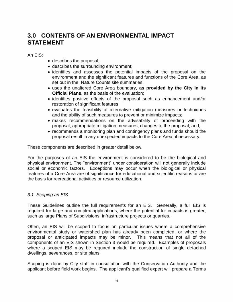
3.0 CONTENTS OF AN ENVIRONMENTAL IMPACT STATEMENT An EIS:
describes the proposal;
describes the surrounding environment;
identifies and assesses the potential impacts of the proposal on the environment and the significant features and functions of the Core Area, as set out in the Nature Counts site summaries;
uses the unaltered Core Area boundary, as provided by the City in its Official Plans, as the basis of the evaluation;
identifies positive effects of the proposal such as enhancement and/or restoration of significant features;
evaluates the feasibility of alternative mitigation measures or techniques and the ability of such measures to prevent or minimize impacts;
makes recommendations on the advisability of proceeding with the proposal, appropriate mitigation measures, changes to the proposal; and,
recommends a monitoring plan and contingency plans and funds should the proposal result in any unexpected impacts to the Core Area, if necessary.
These components are described in greater detail below. For the purposes of an EIS the environment is considered to be the biological and physical environment. The “environment” under consideration will not generally include social or economic factors. Exceptions may occur when the biological or physical features of a Core Area are of significance for educational and scientific reasons or are the basis for recreational activities or resource utilization. 3.1 Scoping an EIS
These Guidelines outline the full requirements for an EIS. Generally, a full EIS is required for large and complex applications, where the potential for impacts is greater, such as large Plans of Subdivisions, infrastructure projects or quarries. Often, an EIS will be scoped to focus on particular issues where a comprehensive environmental study or watershed plan has already been completed, or where the proposal or anticipated impacts may be minor. This means that not all of the components of an EIS shown in Section 3 would be required. Examples of proposals where a scoped EIS may be required include the construction of single detached dwellings, severances, or site plans. Scoping is done by City staff in consultation with the Conservation Authority and the applicant before field work begins. The applicant’s qualified expert will prepare a Terms

7
of Reference outlining the contents and scope of the EIS to the satisfaction of the City and Conservation Authority. Terms of Reference must clearly indicate which field studies are to be undertaken and what sampling methods will be used. They should also outline the content of the report, following these Guidelines. For complex proposals, ESAIEG may also review the Terms of Reference. A scoped report will still include the components listed below, however the detail required may be modified. 3.2 Describing the Proposal A description of the proposal and the property must include:
what is proposed;
the purpose of the proposal;
the timing of construction/development;
the existing land use and activities on-site;
a general site location map, showing main roads;
a preliminary site plan, at an appropriate scale, and with dimensions, showing the proposed location of all buildings/structures, septic areas (rural area only), grade changes, driveways, etc., overlaid on an air photo;
a recent air photo map of the subject site at a scale of approximately 1:2000 identifying:
o the limits of the Core Areas as shown in the Official Plan or using mapping provided by the City;
o vegetation communities, based on OMNR Ecological Land Classification (ELC) for Southern Ontario;
o Provincially Significant Wetlands (PSW), as well as other wetland areas as defined by the Ontario Ministry of Natural Resources and the Conservation Authority;
o permanent and intermittent water features such as headwaters, rivers, streams, lakes and ponds, caves, sinkholes, stream sinks, springs, and seeps;
o regulated areas, as defined by the Conservation Authority; and, o topographic contour lines.
activities associated with the proposal which may have an environmental impact (e.g. work on stream banks, tree-cutting, removal of vegetation, earth-moving, excavation and post-construction activities); and,
Other development applications known to be in progress in the area which would affect the natural heritage features.
3.3 Describing the Site and the Surrounding Environment (Biophysical Inventory) The description of the surrounding environment will be completed through a biophysical inventory. Three levels of investigation may be used for any feature to be described. In increasing degree of thoroughness, these are:

8
secondary sources (compiling information from existing documents);
limited field inventory; or,
detailed field inventory. The area requiring study may be different for the various ecological and physical elements. The reasoning behind the choice of study areas, the level of investigation, and the seasons or times of year of the study should be approved by the City in consultation with the Conservation Authority, when developing the Terms of Reference. For example, where downstream impacts might be expected, the study area for aquatic habitat should extend downstream. Field data from previous studies may be used as a secondary source of information, but must be updated if collected more than 5 years ago. This is important because natural area boundaries, ecological community composition, and listed species at risk change over time, sometimes quite dramatically. The EIS should include a table showing the date/time of the survey, level of survey effort (e.g. person hours), weather conditions, and the name of the surveyor(s). The EIS report must include all field studies and information outlined in the Terms of Reference. Particular attention should be paid to those features of the Core Area identified as significant in the Nature Counts Project report. The biophysical inventory should address the significance of the features in the area studied and the importance of those features to the Core Area as a whole. The locations of any significant species or features should be mapped in detail. The Planning and Economic Development Department and the relevant Conservation Authority can help in identifying secondary data sources and should be consulted by the landowner. For example, site summaries from the Nature Counts Project are available from the Planning and Economic Development Department. The Conservation Authorities and other government and non-government organizations may have additional information on particular areas. The Hamilton Conservation Authority is the depository for the Hamilton Natural Heritage Database, which is updated annually. Information can be obtained by contacting the Ecologist at (905) 525-2181. It may be beneficial to obtain input from local residents surrounding the subject site, relating to any wildlife they have noticed. This is particularly useful for species which are difficult to detect using field methods (eg. reptiles). Local residents often have information about the property that is useful. The EIS should discuss the significance of the entire Core Area, as well as the portion affected by the proposal. The EIS should identify the boundaries of Core Areas and, once approved, will provide confirmed boundaries to be surveyed for the final development plan.

9
The biophysical inventory will identify the following:
a) physical and hydrologic features, including:
soil types by texture/grain size (e.g. clay, silt sand) and drainage characteristics;
overburden and bedrock geology;
landforms;
areas of high water table;
areas of groundwater recharge and discharge;
locations and usage of wells;
drainage patterns, basin boundaries, ponds, lakes and watercourses (sampling should be carried out at a time of year when these features/systems are evident (spring, during storm events) to document the function of such features/systems); and,
existing erosion sites.
b) biological features, including:
a description of ecological communities identified during the appropriate season(s) * to the Vegetation Type level described according to the most recent version of the Ontario Ministry of Natural Resources Ecological Land Classification System for Southern Ontario (May to October);
an assessment of the condition of the vegetation community (May to October), with reference to successional state, degree of disturbance, and the extent of invasive plant species;
for the vegetation survey, species rarity status, coefficient of wetness and floristic indices should be included;
the location and status of wildlife species and their habitat including birds, mammals, reptiles, fish, amphibians, butterflies, and odonates;
the location and relative abundance of threatened, endangered or special concern species at the federal and provincial levels;
the location of locally uncommon or rare species, according to the Nature Counts Project report or Hamilton Natural Heritage Database;
the location of aquatic habitat and fish communities, including spawning grounds, nursery, rearing, food supply, and migration areas of all intermittent and permanent streams and water bodies. Sampling should be carried out when fish and water are most likely to be present for intermittent streams (late April-June and September to October). Fish habitat surveys completed during the winter months under snow/ice conditions will not be accepted;
locations should be provided as GPS co-ordinates for all plant and animal species that are listed as uncommon or rare within Hamilton, ranked S1 to S3 in the Province, or are considered Special Concern, Threatened, or Endangered. An estimate of abundance for Species at Risk should also be provided; and,
an inventory of species present in the study area, including:

10
- botanical survey in spring (May to early June), summer (July to August), and fall (September to October) using commonly acceptable sampling and recording methods;
- breeding birds (late May to early July), with the first survey between May 24 and June 15, and the second between June 15 and July 10, using Ontario Breeding Bird Atlas protocols;
- amphibians (amphibian breeding from early spring to summer) and later incidental sightings using Ontario Marsh Monitoring Protocol;
- reptiles using active searching, cover boards, or other commonly accepted methods (April to July and September to October);
- mammals – incidental sightings or signs; bat surveys may be required in areas where suitable habitat exists for bat maternity colonies, migration areas, or hibernacula;
- fish and aquatic organisms, using commonly accepted sampling methods (Ontario Stream Assessment Protocol and Ontario Benthos Biomonitoring Network Protocol);
- Butterflies, dragonflies, and damselflies – incidental sightings (spring-fall), including adult and larval stages; and,
- targeted surveys for specific species may be required (e.g. certain Species at Risk if known to occur in the study area).
* Note: The timing of species surveys is critical and therefore the most appropriate season for specific surveys should be identified. Review of an EIS will be delayed pending the completion of an appropriate seasonal survey. If biological inventory work is proposed outside of the normal season or only during one season, approval must first be given by the City (through the Terms of Reference for the EIS). In addition to this, any deviation proposed from the data survey protocols listed above must first be approved by the Natural Heritage Planner.
c) landscape features, including:
the location of the subject lands in relation to Core Areas and Linkages within the Natural Heritage System. Linkages are identified on Schedule B (Natural Heritage System) of the Hamilton Official Plans. For these areas, a Linkage Assessment may be required, according to the City of Hamilton Linkage Assessment Guidelines. The Linkage Assessment can be included as part of the EIS report, provided the requirements of the LA Guidelines are followed.
a description and analysis of the existing ecosystem both within the subject site and as it relates to the larger regional ecosystem, including, but not limited to the following:
- Locally significant natural areas, as defined in the Official Plans;

11
- Ecologically functional natural linkages and potential linkages, as shown on Schedule B (Natural Heritage System) in the Official Plans; and,
- Significant Wildlife Habitat and Functions (e.g. migration staging areas, deer yards, snake hibernacula, wintering habitat) as identified in the Significant Wildlife Habitat Eco-Region Criteria Schedules (OMNR, 2012).
the area studied for each of the above elements. A map should be provided showing the sampling locations. The presence of a Species at Risk (SAR) should be filed with the Natural Heritage Information Centre (NHIC) in Peterborough and the Hamilton Conservation Authority for inclusion in the Hamilton Natural Heritage Database. NAD 83 or UTM locations of SAR and locally uncommon and rare species should be recorded. Due to the sensitive nature of the data, the location of SAR should not be included in the EIS.
3.4 Identifying and Assessing the Impacts of the Proposal When assessing potential impacts, the EIS report must include a section addressing the Natural Heritage System policies in the applicable Official Plan and how the proposal is consistent with them. It is important to take the information from the studies and the development proposal and relate it back to the Official Plan policies. This policy context section will provide a framework for analyzing impacts. The EIS must describe the significance of any negative or positive effects of the proposal on the features of the Core Area identified in the biophysical inventory, and should describe:
the sensitivity of the features and functions of the Core Area and how the development proposal could affect them;
the impacts in terms of area and likely duration;
direct on-site effects (e.g. clearing, grubbing, grading, encroachment, fragmentation or elimination of habitat, removal of trees, enhancement and/or restoration of significant features);
indirect effects (e.g. sediment transported downstream, diversion of water flows, ponding, changes in volume and water quality of surface runoff);
effects on the ecological features and functions of the whole Core Area (e.g. loss of habitat, edge effect, change in habitat – relate to the criteria for which the area was identified as a Core Area);
short-term (during and post-construction) and long-term effects (residency impacts such as litter, encroachment, dumping, invasive species, vegetation removal, light and noise impacts);
secondary effects (e.g. changes to the aesthetic qualities or the educational value of the area, obstructions of greenway connections, effects on adjacent natural areas); and,

12
cumulative impacts. Provide an assessment of the apparent impacts of previous development applications, other development applications currently under review, or land use activities on the identified environmental features and functions (including trails, dumping, excavation and fill, encroachment, and introduced plant species).
3.5 Avoiding Impacts and Evaluating Alternative Mitigation Measures Avoiding negative impacts is preferred over mitigation. The intent of the Natural Heritage System policies is to preserve and enhance habitat that currently exists. Ways of avoiding impacts should be listed and evaluated, including modifying the basic proposal (should the development proceed, can it be re-designed?). Where negative impacts are unavoidable, a range of mitigation measures to reduce or minimize significant impacts should be evaluated. Examples include site plan modifications, improved construction practices, storm water management, or relocation of the development. The relative effectiveness of implementing these measures should be estimated and the extent of any remaining impacts discussed. This section should include the following:
an analysis of buffers and setbacks that are relevant to the potential impacts of the proposal and the Core Area features to be protected. The Hamilton Official Plans set out policies for minimum buffer widths (Vegetation Protection Zones) (see Appendix 2);
how the proposal was designed to avoid and/or minimize impacts;
a description of any proposed compensation for impacts that cannot be mitigated (e.g. fragmented habitat), or restoration plans for disturbed areas; and,
mitigation measures (e.g. lighting, fencing, erosion control, landowner stewardship brochures) proposed to eliminate or reduce impacts.
3.6 Monitoring Plan The purpose of monitoring is to measure impacts over time. Monitoring allows the Planning and Economic Development Department, though conditions of approval or securities, to require changes to site conditions if environmental effects exceed predicted levels, or if negative effects occur that were not previously identified. It also provides a means to ensure that the proponent has implemented all mitigation measures. Monitoring plans should be designed to measure the impacts of the proposal on natural areas over time. To do this, it is essential to have substantial baseline data before implementing a monitoring program. The baseline data will be used as a benchmark from which to measure the extent of impacts of the proposal.

13
Monitoring may be required where:
there is uncertainty as to the effectiveness of established mitigation measures to avoid negative impacts;
new and untested mitigation measures are used; or,
there are some long-term operations associated with a proposal that could facilitate some future or on-going refinement to the mitigation strategy.
Monitoring programs may be established as a condition of approval and may be required for pre-construction, construction, or post-construction phases. Details of the monitoring plan will be specific to the proposal and will be determined by staff and ESAIEG when reviewing the EIS. Monitoring plans should include contingency plans and funds to implement the plan should the proposal result in unexpected negative impacts. Monitoring plans are mostly intended for large scale developments, to avoid long term negative impacts. Not all proposals will require a monitoring plan. 3.7 Recommendations and Conclusions Based on this evaluation, the EIS will outline methods or preferred measures to avoid or mitigate negative impacts. Positive changes and enhancements to the Core Area should also be suggested. Recommendations should outline how the proposal can maintain or enhance ecological functions of the natural area and address the following issues:
should the proposal proceed as planned;
what mitigation measures are required; and,
recommendations for development conditions (i.e. monitoring plan, erosion and sediment control plan, storm water management plan, tree protection plan, rehabilitation/landscape plan, wildlife management plan).
Recommendations should also be included for long term management, conservation, enhancement, and monitoring of significant environmental features and functions on the subject property or adjoining lands. 3.8 Format of the EIS Three hard copies and one digital (pdf) copy of the EIS should be submitted to Planning and Economic Development Department staff. A hard copy of the data collected during the EIS (i.e. ELC data sheets, wildlife and plant species lists) should be included in the Appendix of the EIS. Data should also be submitted in electronic format where possible. Species lists should be coded

14
consistently with the Nature Counts Inventory, and should include the dates of fieldwork and weather conditions. Appendices to the EIS should provide a bibliography of literature cited and the qualifications of the study team (resumes or C.V.s).
4.0 WHAT IS THE PROCEDURE? The process outlined below is designed to allow for timely and efficient review of development applications in and adjacent to Core Areas by focusing on early consultation to identify issues and requirements. The EIS must be prepared in the early stages of a proposal’s consideration by the City. Since one purpose of an EIS is to guide the design of a development proposal to avoid or minimize environmental impacts, an EIS cannot be dealt with as an afterthought or as a condition of approval. When an EIS is required, the following procedure should be followed: a) Consultation With City Staff Typically, for Official Plan and Zoning By-law Amendments, Plans of Subdivision, and Site Plans, the requirement for an EIS is identified during the Formal Consultation process with City staff. For Niagara Escarpment Permits, Variances, and Severances, the requirement for an EIS will be identified when an application is submitted to the City. Before beginning work on the EIS, the proponent should contact a Natural Heritage Planner at the City of Hamilton to discuss the requirements for the EIS (level of study detail required, issues to be addressed, timing of field work). Planning and Economic Development Department staff can also direct the applicant to data resources and provide advice on Official Plan policy. This early discussion provides guidance to the applicant that can minimize the time and cost of preparing the EIS. b) Preparing the EIS report The proponent must retain a qualified expert to prepare the EIS. The consultant must prepare a draft Terms of Reference (TOR) for the EIS which outlines the field studies to be carried out, timing, extent of the study area, and content of the report. This allows the EIS to be scoped to address the specific issues and ecological and physical characteristics of the site. Once the TOR is approved by the City in consultation with the appropriate Conservation Authority, the consultant can begin work on the EIS. In some cases (i.e. complex applications), the Terms of Reference will be reviewed by ESAIEG. It is also advisable at this point to conduct a site visit with a City Natural Heritage Planner and the appropriate Conservation Authority to stake the boundaries of the Core Area features. By identifying the boundaries of natural features early in the process, the applicant has a clear indication of the natural area limits. To ensure that stake locations are quickly and accurately captured, a surveyor must also be on site during the staking,

15
using either a GPS unit or OLS survey. Stakes should also be numbered in the field and surveyed with these numbers, to ensure that all stakes are captured. For more information on Core Area boundary delineation, please refer to “Principles for Delineating Core Areas in the Field” in Appendix 1. It should be noted that the boundaries of the Core Area may change based on the results of the EIS and the ESAIEG site visit and review. In this way, the Core Area boundary is not considered to be final until the EIS is approved by the City. c) EIS Submission and Review When the EIS is completed, the proponent will submit three hard copies and one digital (pdf) copy to the Planning and Economic Development Department. Staff will review the EIS to ensure it is complete and complies with the Terms of Reference before submitting it to ESAIEG. Staff will also circulate the EIS to appropriate agencies for their review. Please note that the City and individual agencies may refuse to review an EIS that does not fulfill the requirements in these Guidelines or the approved Terms of Reference. The City will require a digital copy (shape files) of the Core Area boundaries and the Ecological Land Classification polygons to assist in refining City Natural Heritage System mapping. ESAIEG will conduct a site visit and discuss the EIS at their monthly meeting. The applicant will be asked to attend this site visit and meeting and make a presentation to the group. Natural Heritage staff record ESAIEG recommendations and advise the applicant on whether additional information is required. For example, sometimes ESAIEG will request additional field surveys or more information on storm water management or servicing. If additional information is necessary, the applicant will prepare the revised, final EIS or an EIS Addendum based on ESAIEG and staff comments. Occasionally, ESAIEG will ask to review additional plans and studies, such as Storm Water Management Plans, Hydrogeologic Studies, and Landscape Plans. EIS reports are reviewed by the City’s Natural Heritage Planner and ESAIEG. They may also be reviewed by staff from the appropriate Conservation Authority, Ontario Ministry of Natural Resources and Forestry, and Niagara Escarpment Commission. The applicant should be aware that these agencies may also provide comments on EIS reports, as they relate to their respective areas of interest. d) Implementation of EIS Recommendations The recommendations from the final approved EIS will be incorporated into development agreements (usually as conditions or through an Undertaking Agreement) between the City and the applicant or implemented through the Zoning By-law or Site Plan Control. In addition, the EIS may recommend changes to site design, to avoid impacts to the Core Area.

16
Other Procedural Notes: If a development proposal is significantly revised after the approval of an EIS, an updated study may be required. Also, if field studies have been conducted more than five years before the EIS report or development application are submitted, updated studies will be required. It is the responsibility of the applicant to retain qualified experts, which may include biologists, hydrogeologists, environmental planners, ecologists, landscape architects, arborists, or engineers depending on the scope of work to be completed as part of the EIS. The resumes or CVs of staff contributing to the EIS should be included in the report.

17
Appendix 1: Principles for Delineating Core Areas in the Field Boundaries of Core Areas are identified in Hamilton’s Official Plans (Schedule B, Natural Heritage System). However, since these boundaries are general and natural areas can change over time, Core Area boundaries are identified and staked in the field at the time that an EIS report is being prepared. Typically, the City’s Natural Heritage Planner and Conservation Authority staff walks the site with the applicant’s qualified expert to identify and stake the Core Area boundaries before the EIS is completed. It is essential that a surveyor be present at the time of the staking to ensure that the boundary is accurately identified using GPS coordinates. Any changes proposed by the applicant’s qualified expert to the staked Core Area boundary must be justified in the EIS report and approved by the City, appropriate Conservation Authority, and ESAIEG. Occasionally, there are questions about how the City and ESAIEG delineate the boundaries of Core Areas in the field. To provide guidance to applicants and their ecological experts, City staff and ESAIEG have prepared a list of principles. Since each site is unique and must be considered based on its own characteristics, deviations from the principles are possible. However, applicants and their ecological experts should be aware of these principles so that they understand the reasoning behind Core Area boundary delineation. When delineating a Core Area boundary, the following basic principles are followed:
- Boundaries of Core Areas will be established based strictly on ecological principles. Broader land use planning considerations are addressed during the planning process, where aspects such as the desired land use, servicing, road alignment, community design, and engineering requirements are considered.
- Core Areas are identified based on significant ecological, hydrologic, and
geomorphic features. Their boundaries are identified based on landforms, natural vegetation, and associated ecologic and hydrologic functions that are generally free from permanent disturbance and that can be distinguished from the surrounding land use.
- Areas of habitat required for Species at Risk or locally rare species will be
included within boundaries. These include areas that are used regularly for key lifecycle requirements such as feeding, breeding, dispersal, and resting.
- It is expected that ELC communities form the basis for delineating Core Area
boundaries. If a particular ELC community is to be included, the boundary of the Core Area must include the entire ELC unit.

18
- Generally, wooded Core Areas (Significant Woodlands, ANSIs, ESAs) will be
delineated based on the drip line of the trees on the edge of the woodland. The drip line is defined as an imaginary line drawn down to the ground from the outermost branches of a tree. Often, the edge of the woodland is fairly distinct. However, if there is adjoining successional or non-wooded habitat, this should also be included if it contributes to and supports the ecological function of the Core Area.
- Core Area boundaries are to be identified based on existing features at the time
of field staking and study. Sometimes, historic air photos are presented to the City to illustrate that, many years ago, the Core Area was an immature community, or did not even exist. If a natural feature exists at the time of the application, then it must be considered for its current ecological value.
Cultural Habitat: Cultural habitat is defined as a vegetation community originating from, or maintained by anthropogenic influences or culturally-based disturbances (e.g. pastures, tree planting and harvesting, and clearing for agricultural use). These communities often contain a high percentage of non-native plant species, and are undergoing natural succession. Generally, tree cover is less than 60 percent (Lee et. al. 1998). Cultural habitat includes old field meadow, thicket, cultural savannah, and cultural woodlands (plantations). Identification of vegetation communities must follow Ecological Land Classification (Lee et, al. 1998). Cultural habitat may provide supporting habitat to the Core Area, and is particularly important where the loss of these communities would result in the loss of the ecological integrity of the whole Core Area. They also are known to contribute to the biodiversity of an area, since species within the Core Area will also use cultural habitat for some of their life cycle needs. Some locally rare or Special Concern species, such as Common Nighthawk, Eastern Wood-Pee-Wee, and Milk Snake, may use cultural habitat; this habitat should therefore be included within the Core Area. Cultural habitat has the potential for rehabilitation and can contribute to overall ecosystem function (control of water quality and quantity, erosion control, improved air quality and aesthetics), especially in urban and agricultural landscapes. Depending on what ecological function it provides, cultural habitat may be identified as part of the Core Area, or as a Linkage, or included as part of the VPZ. Cultural habitat adjacent to Core Areas can provide important breeding and foraging areas for wildlife (i.e. Core Area), connections between natural areas allowing for wildlife and plant movement (i.e. Linkage), or can serve as buffers to protect more sensitive areas from adjacent land uses (i.e. VPZ). It is important to examine the ecological function of the habitat, rather than focusing on whether it is “cultural” or “natural”.

19
When assessing the importance of cultural habitats, the following is considered:
Presence of locally rare species, or Species at Risk;
Contribution to wildlife habitat (including the life cycle requirements of common and uncommon species);
Successional stage and its representation in the local area;
Contributing to the number of different habitat types (e.g. woodland, wetland, thicket, meadow, riparian);
Ability to strengthen internal linkages in the Core Area by filling in habitat gaps;
Linkages to facilitate wildlife movement between Core Areas; and,
Minimizing negative edge effects by forming a well-established mantle at the edge of the Core Area and, as such, protecting the Core Area from the effects of surrounding land uses. It is often possible to protect cultural habitats within the required VPZ.
Edge Habitat: Edge habitat is the transition area between two different habitat types/land uses along the boundary that separates them. There are positive and negative aspects to edge habitat. On the positive side, the edge contains habitat common to both communities as well as habitat unique to the transition zone itself. Because of this, edge habitat can have greater biodiversity and population density than in either of the individual communities. However, sometimes edge habitat can be considered to be lower-quality, because it bears the brunt of disturbances from adjacent land uses, including noise, light, wind, trampling, vegetation removal, predation by pets, parasitism, and invasive plants and animals. Edges often contain invasive plants and wildlife. While the City recognizes that edge habitat can be degraded, it is important to retain because it provides a buffer or line of protection against these negative influences. If edge habitat is removed from a Core Area, the new edge moves inward. Negative impacts are able to penetrate further into the significant Core Area, degrading its ecological value. For these reasons, edge habitat will generally be included in the boundary of the Core Area for the contributions it makes to supporting ecological functions and biodiversity.

20
Appendix 2: Information on Buffers (Vegetation Protection Zones, VPZs): A buffer (or vegetation protection zone, VPZ) is a linear, vegetated strip established or maintained between a natural area and an adjacent land use which serves to minimize impacts on the natural area and its ecological functions. VPZs provide physical separation from an abutting land use and are commonly recommended in EIS reports to mitigate impacts on Core Areas. In the new Official Plans, the City of Hamilton has identified minimum VPZ widths for different natural feature types. These are outlined in the following tables: Table 1: Rural Hamilton Official Plan Recommended Minimum VPZs:
Natural Feature VPZ minimum
Permanent and intermittent streams 30 metres, on either side of the stream, measured from beyond stable top of bank
Wetlands (PSWs and local wetlands) 30 metres, measured from wetland boundary as delineated under the Southern Ontario Wetland Evaluation System
Fish habitat 30 metres, measured from beyond either side of top of bank or meander belt allowance
Woodlands 15 metres, measured from drip line of trees on woodland edge
Significant Woodlands 30 metres, measured from the drip line of trees on woodland edge
Life Science Areas of Natural and Scientific Interest (ANSIs)
30 metres
Significant Valley lands 15 metres, measured from top of bank
Lakes 30 metres, measured from stable top of the shoreline
Urban Hamilton Official Plan minimum VPZ Guidelines differ slightly from those in the Rural Area, as shown in Table 2.

21
Table 2: Urban Hamilton Official Plan Recommended Minimum VPZs:
Natural Feature VPZ Minimum
Coldwater Watercourse and Critical Habitat
30 metres, on either side of stream, measured from bankfull channel
Warmwater Watercourse and Important and Marginal Habitat
15 metres, on either side of stream, measured from bankfull channel
Wetlands (Evaluated as PSWs or Local Wetlands) and Unevaluated Wetlands greater than 2 hectares in size.
30 metres, measured from the boundary of the wetland
Wetlands – Unevaluated wetlands less than 2 hectares in size
30 metres, measured from wetland boundary, unless an EIS can justify a smaller VPZ
Woodlands 10 metres, measured from drip line of trees
Significant Woodlands 15 metres, measured from drip line of trees
Areas of Natural and Scientific Interest (ANSI)
15 metres
Valleylands As required by the relevant Conservation Authority
The City recognizes that VPZ widths must be flexible and adaptable to site specific conditions. Because each site is different and VPZs perform different functions, the City has provided minimum guidelines for VPZ widths based on habitat type. As a rule, the minimum VPZ width recommended in the Official Plan, Secondary Plan, or subwatershed study should be used unless scientific evidence is provided in the EIS which shows that the natural area and its ecological functions will be adequately protected by a narrower VPZ. At disturbed sites which are undergoing re-development adjacent to Core Areas in the Urban Area, VPZ widths narrower than the recommended minimums may be considered on constrained sites when scientific evidence in the EIS confirms that a reduced VPZ will not negatively impact the Core Area. Factors to Consider when Determining VPZ Widths:
sensitivity of natural feature, existing functions and values of natural area;
topography of site, soils, hydrology;
type of land use and its expected impact. Land uses with significant construction and post-construction impacts need larger VPZs. Residential/commercial land uses present higher human impacts (trampling, dumping, noise, light) which require larger VPZs than agricultural uses. More intense land uses need wider VPZs;

22
the desired function of the VPZ (e.g. nutrient removal, flood attenuation, erosion control, noise and light reduction, aesthetic improvement, wildlife habitat, deterring human intrusion, etc.);
level of development/disturbance already in the area (cumulative impacts);
level of disturbance likely to occur post construction;
VPZ characteristics (type of planting, species used, density, size, shape, how buffer will be managed); and,
VPZs should be designed for multiple objectives/functions.
Other Notes on VPZs:
grading and site alteration are generally not permitted within VPZs. VPZs must be maintained as natural, self-sustaining vegetation. If grading and site alteration are approved within the VPZ (as part of the EIS), it should be restored;
only non-invasive (and preferably locally sourced) plants which are native to Hamilton (as identified in the Hamilton Natural Heritage Database) will be permitted in VPZ plantings. Species recommended for restoration must be native to Hamilton as identified in Nature Counts/Hamilton Natural Heritage Database;
permitted uses within a VPZ will be limited to low impact uses, similar to those permitted within the Core Area. These uses can include resource management, vegetation restoration, and open space; and,
development lots must be located outside of the VPZ. Since VPZs must be maintained as naturally vegetated areas, they cannot be included within the proposed development. By keeping the VPZ outside of the development area, this reduces the possibility that future landowners will remove vegetation within the VPZ to build pools, sheds, gardens, etc.

23
References: City of Hamilton, EIS Guidelines, 2004. City of Hamilton, Rural Hamilton Official Plan, effective March 7, 2012. City of Hamilton, Urban Hamilton Official Plan, 2009, approved by the Ontario Municipal Board, effective August 16, 2013. Conservation Halton Environmental Impact Study Guidelines, 2005. Lee, H.T., W.D. Bakowsky, J. Riley, J. Bowles, M. Puddister, P. Uhlig, and S. McMurray. 1998. Ecological Land Classification for Southern Ontario: First Approximation and its Application. Ontario Ministry of Natural Resources, Southcentral Science Section, Science Development and Transfer Branch. Ontario Ministry of Natural Resources. March, 2010. Natural Heritage Reference Manual for the Natural Heritage Policies of the Provincial Policy Statement, 2005. Second Edition. Toronto:Queen’s Printer for Ontario. 248 pp. Ontario Ministry of Natural Resources. February 2012. Draft Significant Wildlife Habitat Ecoregion 6E and 7E Criterion Schedules. Ontario Ministry of Municipal Affairs and Housing. Greenbelt Plan, 2005. Ontario Ministry of Municipal Affairs and Housing, Provincial Policy Statement, 2005. Ontario Ministry of Municipal Affairs and Housing. Provincial Policy Statement, 2014.
Definitions: Qualified Expert: means a technical expert in fields relevant to the natural environment, including an ecologist, biologist, hydrogeologist, arborist/forester, or geologist depending on the area of expertise required. In some cases, expertise in storm water management, geology, aquatic ecology, terrestrial ecology, hydrogeology, fluvial geomorphology will be required.