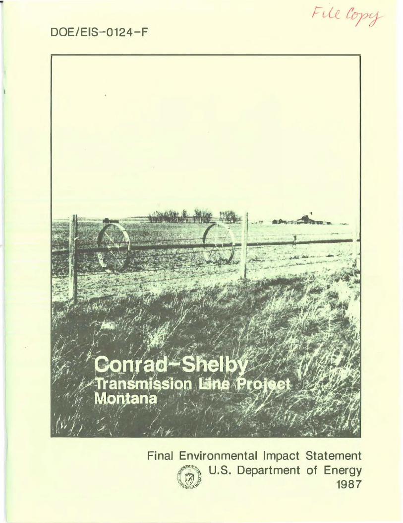
DOE/EIS-0124-F - energy.govenergy.gov/sites/prod/files/2015/04/f22/EIS-0124-FEIS.pdfDOE/EIS-0124-F...
39
- DOE/EIS-0124-F Final Environmental Impact Statement � U.S. Department of Energy � 1987
Transcript of DOE/EIS-0124-F - energy.govenergy.gov/sites/prod/files/2015/04/f22/EIS-0124-FEIS.pdfDOE/EIS-0124-F...
-
DOE/EIS-0124-F
Final Environmental Impact Statement
� U.S. Department of Energy
� 1987
FINAL
ENVIRONMENTAL IMPACT STATEMENT
CONRAD-SHELBY TRANSMISSION LINE PROJECT
US DEPARTMENT OF ENERGY WESTERN AREA POWER ADMINISTRATION
1987

FINAL ENVIRONMENTAL IMPACT STATEMENT (FEIS) CONRAD-SHELBY TRANSMISSION LINE PROJECT
PONDERA " TOOLE COUNTIES, MONTANA
Lead Agency: U.S. Department of Energy, Western Area Power Administration
For further information contact:
James D. Davies, Area Manager Billings Area Office P.O. Box EGY Billings, Montana 59101 (406) 657-6525
ABSTRACT The Western Area Power Administration (Western) proposes to construct, operate, and maintain approximately 29.8 miles of new 230-kV transmission line between Conrad and Shelby, Montana. The project also includes relocation of approximately 4.9 miles of the existing Havre-Shelby 115-kV transmission line, construction of a new 230/115-kV substation (Shelby No. 2) and construction of approximately 2.6 miles of new 115-kV transmission line to interconnect the proposed Shelby No. 2 and existing Shelby No. 1 substations. The project involves a total of approximately 36 miles of new transmission line. The area is presently served by a single transmission loop consisting of 115-kV and 161-kV facilities. This system is in urgent need of improvements to correct low voltages, overloaded facilities, and loss of service that has been experienced and which will worsen as loads grow in the area. The proposed action would provide improved service to area loads and system reliability, contribute to energy conservation, and provide additional flexibility for future expansion when and if it becomes necessary. Alternatives considered include no action, energy conservation, other generation sources, other transmission systems and technologies, and the proposed action with routing and design alternatives. Unavoidable adverse effects of the proposed action would be construction related impacts on land use, visual, and biological resources.

�) I
PREFACE
The Environmental Impact Statement (EIS) prepared for the Conrad-Shelby Transmission Line Project consists of the Draft Environmental Impact Statement (DEIS) (U.S. Department of Energy, 1986) and this document, the Final Environmental Impact Statement (FEIS). The two documents are intended to be reviewed together.
The DEIS, issued in November 1986, contains a statement of purpose and need for the proposed project, a discussion of the scoping process and project-related studies, a discussion of alternative actions, and an analysis of the affected environment and environmental consequences of the proposed action for routing alternatives studied. The DE IS underwent extensive public review by government agencies, organizations and individuals during an official comment period that included public hearings in the project area.
This document contains:
1. A comprehensive summary of the DEIS and FEIS.
2. A description of the public review process, comments from letters and hearings on the DEIS, and Western's responses to comments (Chapter I).
3. National Historic Preservation Act Consultation (Chapter II).
4. Corrections and revisions of data in the DE IS (Chapter III).
Copies of the FEIS have been sent to all agencies, organizations, and individuals listed in Chapter VI of the DEIS, and to all agencies, organizations, and individuals who have since requested copies.
����"---

T
TABLE OF CONTENTS
PAGE
SUMMARY .......... ........ ........................................................................ . . ......... . . . . ........ S-l
A. Introduction ............................................................................................. S-l
B. Need and Purpose ................................................................................... S-l
C. Alternatives Including the Proposed Action .............................................. S-l
D. Proposed Action ...................................................................................... S-3
E. Alternative Corridor and Substation Comparison ....................................... S-3
F. Public Involvement And Review Process .................................................. S-4
G. Affected Environment ............................................................................... S-4
1. Human Environment ........................................................................ S-4 2. Cultural Environment ....................................................................... S-5 3. Natural Environment ........................................................................ S-5
H. Environmental Consequences .................................................................... S-6
1. Impact Assessment/Mitigation Planning Process .............................. S-6 2. Impacts to the Human Environment ................................................ S-6 3. Impacts to the Cultural Environment ............................................... S-8 4. Impacts to the Natural Environment.. .............................................. S-9
I. Electrical Effects ..................................................................................... S-10
J. Environmentally Preferred Route ............................................................. S-11
1. Land Use ........................................................................................ S-ll 2. Visual Resources ............................................................................. S-12 3. Biological Resources ........................................................................ S-12 4. Cultural Resources .......................................................................... S-12
I. PUBLIC COMMENTS AND RESPONSES .............................................................. 1-1
II. NATIONAL HISTORIC PRESERVATION ACT CONSULTATION ........................ 11-1
III. ERRATA AND CHANGES TO THE DEIS ......................................................... 1II-1
APPENDIX A - References and Personal Contacts
LIST OF TABLES
PAGE
TABLE 1-1. INDEX TO PUBLIC COMMENTS . . . . . . . . . .. . . . ...... . . . . . . . . . . . .......... . . .. . . . ....... . 1-2
TABLE 1-2. COMPLETE LETTERS AND RESPONSES ... . . ............... . . . . . . . . ...... . . .. . ... ·1-3
TABLE 1-3. PUBLIC HEARING COMMENTS . . . . ... . . . . .. . . . ....... . . . . .. . . . . .. . .... . . . . . . ..... . . . . . 1-42
LIST OF FIGURES
PAGE
FIGURE 11-1. LOCATION FOR ADDITIONAL CULTURAL RESOURCES SURVEY . . . . .. . . . . ............ ....... . .... . ......... . . . . . . . . . ... . . . . . . . . . . . . . ... ........... . . ....... 11-2
SUMMARY
A. Introduction
The Western Area Power Administration (Western) is proposing to construct, operate, and maintain a 230-kV transmission line between Conrad and Shelby, Montana including a new 230/115-kV substation near Shelby, which would be interconnected with the existing Shelby 115/69-kV substation. This environmental impact statement (EIS) was prepared in compliance with the National Environmental Policy Act of 1969 (NEPAl, the Council on Environmental Quality (CEQ) regulations for the implementation of the procedural requirements of NEPA, the Department of Energy guidelines for compliance with NEPA, and other' applicable legislation.
B. Need and Purpose
The electrical needs of the Cut Bank-Shelby area in north central Montana are presently served by a 115-kV transmission loop beginning at the Rainbow Substation near Great Falls and running northwest to Conrad and Cut Bank, and then east to Havre (Figure 1-1, DEIS). A segment of 161-kV transmission line completes the loop to the Rainbow Substation. A portion of the loop receives support from the Great Falls-Conrad 230-kV transmission line. Subtransmission service in the Cut Bank-Shelby area is supported by a 69-kV system. Power simulation studies and operational experience have both demonstrated an urgent need for improvements to the 115-kV transmission system. Low voltages, overloaded facilities, and loss of load conditions presently occur with an outage of the Conrad-Cut Bank (Valier) 115-kV line, Havre-Rudyard 115-kV line, or Havre 161/115-kV transformer. In the future, system voltages and facility loadings will be unacceptable during both outage and system intact conditions.
The proposed action would: 1) provide improved service to area loads, 2) improve system reliability, 3) contribute to energy conservation, and 4) provide flexibility for future system expansion.
C. Alternatives Including the Proposed Action
The categories of alternatives considered for meeting the stated need are no action, energy conservation, other generation sources, other existing or planned systems, other technologies, other ac overhead systems, and the proposed action with routing and design alternatives.
In this EIS, the no action alternative has been interpreted to mean that no new transmission or generation facilities would be constructed by Western between Conrad and Shelby. The consequences of the no action alternative would be: 1) during an outage of the Havre-Rudyard or Conrad-Valier segments of the 115-kV loop, loads in the Cut Bank-Shelby area would experience low voltage, overload, and loss-of-Ioad conditions,
S - 1

and 2) the existing 115-kV line would not be able to support area electrical loads under system intact conditions as early as 1990.
In order to deal with these adverse effects, the local utilities could be forced to undertake selective load curtailments, rolling black-outs, planned voltage reductions, and/or refuse to service new loads. These measures are considered to be unacceptable in terms of normal utility practices.
Western encourages energy conservation, which refers to the elimination of wasteful or unnecessary uses of energy and has the advantage of reducing energy consumption with no documented adverse environmental impacts. While conservation measures employed by Western and its customers will result in some energy savings and reduction in loads, they will not reduce area loads or area load growth in amounts sufficient to eliminate the need for the proposed line between Conrad and Shelby.
Consideration was given to the potential for new electrical generation in the region as an alternative to the proposed action. Generation of electricity for the area is adequate, but reliable delivery is limited by the existing transmission system. Hence, new generation is not a viable alternative.
Another alternative for meeting the stated need would be for Western to transfer energy from Conrad to Shelby using other existing or planned transmission systems. Western presently has contractual rights to use transmission capacity available on certain lines owned by other utilities in the project area. However, some of these facilities are loaded to or above capacity under present system conditions and can no longer provide adequate, reliable service to area loads during peak system intact or outage conditions. None of the other area utilities plan to construct any additional high voltage lines to correct this problem. Therefore, there are no existing or planned transmission facilities owned by other utilities which could meet the stated need for Western's system.
A direct current (de) transmission system was considered as a possible alternative to an alternating current (ac) system, but a de system with the power transfer capability of a 230-kV ac line would cost approximately two to three times as much as an ac line, with no apparent environmental benefits. Underground systems were also evaluated but eliminated because of technical complications, economic and environmental costs, and accessibility, although some aesthetic impacts would be avoided. No other method is presently available for the economical bulk-power transmission of electric energy from a generating source to load centers.
Overhead ac systems other than the proposed action were also considered. These included: 1) capacitor additions at Shelby-Cut Bank, 2) a Conrad-Cut Bank 230-kV line, and 3) a Havre-Shelby 230-kV line. A comparison of these options to the proposed action indicated that the proposed action offered the best combination of costs, savings in transmission line losses, and provision of a third transmission source to area loads.
After investigating the above alternatives, Western concluded that the most reasonable alternative for meeting the stated need and purpose would be a new overhead ac line constructed between Conrad and Shelby. Design alternatives for voltage, structures, and conductor were considered. Results of design-alternative evaluations are incorporated in the following description of the proposed action and routing alternatives.
S - 2
D. Proposed Action
Western proposes to construct, operate, and maintain a single-circuit overhead 230-kV transmission line between Conrad and Shelby, and local reroutes of existing 115-kV transmission lines. The proposed project would consist of the construction of about 29.8 miles of new 230-kV transmission line on single-pole steel or concrete structures between Western's newly completed Conrad 230/115-kV substation and a new Shelby 230/115-kV substation (Shelby No. 2) . The proposed Shelby substation would be built on approximately 5 acres of land about 2.5 miles south of the existing Shelby substation (Shelby No. 1) . About 4.9 miles of the existing Havre-Shelby 115-kV Transmission Line would be removed where it passes through or near the Toole County Fairgrounds, and several residences and/or businesses. It would be replaced by about 3.5 miles of new transmission line constructed to 230-kV standards and terminated in the new Shelby substation. The existing and new Shelby substations would be interconnected by about 2.6 miles of new single-pole 115-kV transmission line. Glacier Electric Cooperative would probably reroute its Cut Bank-Shelby 115-kV transmission line from the existing Shelby substation to the new substation. Environmental impacts associated with this reroute would be studied and mitigated by Glacier Electric Cooperative. The single-pole structures would be 65 feet to 125 feet tall, and span lengths would be from 700 feet to 1,200 feet. The conductor would be a non specular type to reduce light reflection. Use of single-pole structures, along with routing of the lines along field boundaries would help to minimize disturbance to agricultural land in the rural project area.
Construction of the proposed project is scheduled to begin in October 1987 and the system is expected to be operating in December 1988. The anticipated useful life of the project is defined as 100 years.
E. Alternative Corridor and Substation Comparison
The siting and impact assessment of the Conrad to Shelby 230-kV Transmission Line Project was accomplished through a rigorous, systematic process involving six major phases: 1) determining the scope of the environmental studies and assessments to be conducted, 2) conducting resource sensitivity analyses to identify opportunities and constraints to transmission line siting, 3) selecting alternative corridors and substation sites for detailed study, 4) assessing the potential impact of constructing and operating the project at each alternative location and methods for avoiding or reducing those impacts, 5) identifying the " Ieast impact" location and selecting a proposed or II preferred II route for the project, and 6) preparing the EIS for review and obtaining other required environmental reviews and approvals.
Environmental studies including regional-scale and corridor-scale studies were conducted for several alternative transmission line routes between Conrad and Shelby and for substation sites south of Shelby. The principal studies, through which the environmental baseline for impact assessment and mitigation planning was developed, inventoried existing conditions for land use, agricultural, visual, and socioeconomic resources in the human' environment; archaeological, historic, and Native American resources in the cultural environment; and air, geologic, paleontologic, hydrologic, soils, vegetation, and wildlife resources in the natural environment. In addition, studies were
S - 3

also conducted to analyze potential electrical, biological, health, and safety effects from the proposed project.
An extensive public involvement program was conducted which began early in the planning process with scoping meetings and agency contacts to provide information on the proposed project and to solicit early input regarding environmental issues. Further public workshops were held to obtain data for the environmental studies and solicit input on alternative routes and substation sites, including refinement to the "Ieast impact" alternative.
F. Public Involvement And Review Process
An extensive program was conducted early in the planning process to provide information on the proposed project to agencies, groups and individuals; solicit input and obtain data for the environmental studies; identify issues and concerns about the project; and obtain input on the alternative routes and substation sites, including refinements to "Ieast impact" alternatives.
The public review process for the DEIS consisted of soliciting comments from approximately 90 government agencies, institutions, organizations, and individuals to whom the document was sent. Comments were received in the form of letters and remarks made during the public hearings conducted by Western in Conrad and Shelby, Montana.
In response, 14 letters were received commenting on the DEIS. One person presented oral comments for the record at the public hearings. Responses to specific comments are provided in Chapter I of this FEIS.
G. Affected Environment
1. Human Environment
The majority of lands within the study area are in private ownership. Publicly owned lands fall under the jurisdiction of the U.S. Bureau of Land Management (BLM) , the Montana Department of State Lands, and Pondera and Toole counties.
The predominant land use in the study area is agriculture. This part of northcentral Montana is generally included in the area known as the "Golden Triangle" due to the rich agricultural productivity of the region.
Approximately 50 percent of the agricultural lands within the study area are nonirrigated croplands comprised primarily of wheat and barley fields. Irrigated lands producing similar crops comprise 20 to 25 percent of the study area, primarily in Pondera county. On irrigated cropland, the trend is toward center pivot or wheel-type sprinkler systems, while flood irrigation occurs mainly near rivers and drainages. The remainder of the study area is in range or undeveloped lands assodated with steep slopes along drainages.
S - 4
Urban areas within the study area include Conrad and Shelby. Oil and gas wells are dispersed. Military facilities associated with the U.S. Air Force's ICBM Minuteman missile system also occur within the study area.
No class A (outstanding) scenic quality areas occur in the study area. Landscapes are predominantly class C, representing landscapes common to the area. The Marias River corridor is designated class B (above average) scenery. Residential, highway, and recreation foreground (0 - 1/4 mile) views occupy 20 to 30 percent of the study area.
2. Cultural Environment
There are no known archaeological sites in the study area which are listed in or eligible for the National Register of Historic Places (NRHP). One historic site, the Conrad City Hall, is listed on the NRHP. The intensive survey of the environmentally preferred corridor and access road easements, and the visual impact survey adjacent to the corridor, identified 21 sites including 1 that was previously recorded. These resources include 13 prehistoric (9 stone circle(s) , 2 stone circle/stone alignment, 2 stone circle/cairn) , 7 historic (6 homesteads, 1 historic trash dump) , and 1 historic/prehistoric (historic trash scatter and prehistoric biface) . Additional information regarding cultural resources consultation and eligibility determinations may be found on page "-1 of this FEIS.
3. Natural Environment
The project study area in north-central Montana is characterized by cold winters and warm summers. The mean minimum January temperature is about 6 of, and the mean maximum July temperature is 82 of in Shelby. Mean annual precipitation averages 12 to 13 inches, with 60 percent of total rainfall occurring between May and August.
The study area lies along the western edge of the Great Plains Physiographic Province. Area seismicity damage-risk is classified as moderate. The only bedrock unit exposed in the study area is the Kevin Shale Member of the Marias River Formation. The Kevin Member is overlain by glacial till which ranges in composition from clays to pebbles, cobbles, and boulders in a sand and silt matrix. There are seven soil map units delineated within the study area. Three of these map units have associated erosion potential, reclamation sensitivity, and engineering constraint problems. Slumping potential exists in areas of steep slopes along well-incised drainages (coulees). Although fossiliferous strata occur within the study area, the potential for significant paleontological resources is low.
The study area lies within the Marias River Basin, a subbasin of the Missouri River Basin, and is drained by the Marias and Dry Fork of the Marias Rivers which are fed by numerous small coulees. Streamflows exhibit dramatic seasonal fluctuations and ice jams exert significant control over flow in the Marias River. Surface water quality is good. Ground water from deeper formations is highly mineralized but alluvial deposits are important sources of good quality ground water.
S - 5

The vegetative communities present within the study area are prairie, shrublands, breaks, cropland, and riparian. Most of the natural vegetation is prairie although the majority of the upland prairie communities have been plowed and converted to cropland. Two main noxious weed species, spotted knapweed and leafy spurge, have been identified as needing control in the study area. Although the possibility exists that federal- or state-protected plant species may occur, none have been identified.
Cropland, grassland, wetland, and riparian are the four wildlife habitat types occurring within the study area. Big game species are mule deer, white-tailed deer, and pronghorn antelope. Upland game birds include pheasant, partridge, and grouse and waterfowl include geese and ducks. Three species listed as endangered by the U.S. Fish and Wildlife Service (USFWS) may occur in the study area. The peregrine falcon and bald eagle are potential migrants through the area. The black-footed ferret is a potential resident of prairie dog towns.
Significant floodplains occur in the major drainages (Marias and Dry Fork of the Marias Rivers) as do riverine wetland systems. Palustrine wetlands in the study area include marshes and wet meadows, potholes and mudflats, sloughs and river overflows, and seasonal natural ponds, springs, and seeps. Notably missing are lacustrine systems (bodies of water larger than 20 acres).
H. Environmental Consequences
1. Impact Assessment/Mitigation Planning Process
Environmental consequences from the proposed action and alternatives are the residual impacts derived through a process that first identified, and subsequently evaluated and integrated, initial impacts and appropriate mitigation measures. The process involved assessing impacts by: 1) comparing the proposed project with the pre-project environment, 2) determining mitigation that would avoid, effectively reduce, or eliminate impacts, and 3) identifying "residual" impacts, or impacts remaining after the application of mitigation.
Study area-specific impact types and levels as well as mitigation measures were first identified for each resource. Impacts were then evaluated using "reference centerline II
routes which were located within each of the identified alternative corridors such that they occupied the least environmentally sensitive areas. Initial and residual impacts were established on a resource by resource basis for each of the alternative routes. Routes were then compared to identify the "environmentally preferred route".
2. Impacts to the Human Environment
Land use concerns expressed by Pondera and Toole counties, interested agencies, and the public during the project scoping process included potential effects on agricultural practices, interference with aviation and military communication facilities, potential for closely paralleling other linear features such as roads, and. possibilities for following section lines and field boundaries.
S - 6
Within the study area, potentially high and high-to-moderate impacts were assigned for the following situations:
" Agricultural areas where the project: 1) follows field edges of a sprinklerirrigated field, 2) crosses flood-irrigated fields in any location, 3) crosses potentially irrigable land on a diagonal, or 4) where guyed angle towers would be located within cultivated fields. High impacts considered to be unacceptable would result from mid-field or diagonal crossing of sprinklerirrigated fields.
" Urban and residential areas where the project would create a conflict with expansion of residential uses, or cause a direct conflict with commercial, industrial, or transportation uses.
Moderate-to-high or moderate impact levels were assigned for situations where:
" The line would cross nonirrigated cropland along field edges, mid-field, or diagonally.
• The line would follow field edges of potentially irrigable land.
" A conflict with expansion of commercial and industrial facilities would result.
Low impacts were assigned to rangeland locations, taking into consideration the potential for noxious weed establishment in areas disturbed by construction activities.
The most significant potential land use im pacts occurring along the alternative routes are physical conflicts with present and future agricultural activities and removal of cropland from production. Long-term impacts to agricultural resources would be interference with cultivation and weed-control operations around transmission towers, interference with sprinkler irrigation equipment, and potential conflicts with aerial applications.
Western also considered the effects of the proposed project on prime farmlands. There were no maps available showing prime farmland in Toole and Pondera Counties. The only data available was a list of soil types in Glacier and a portion of Pondera Counties that if irrigated would qualify as prime farmland. Within the project study area, soil types are such that irrigation is required to be considered prime farmland. There is no nonirrigated prime farmland in the study area.
For purposes of alternative corridor selection, irrigated farmland was used as an approximation for prime farmland. Thus, on the Generalized Constraint Areas and Land Use maps (Figures 11-8 and 111-1) in the DEIS, the irrigated cropland illustrated was also considered prime farmland. It should be noted, that the maps of irrigated farmland include a significant portion of non-prime farmland. The proposed route crosses one-half mile of prime farmland and impacts to the resource would be minimized by spanning those fields. Sprinkler irrigated farmland was assigned the highest levels of sensitivity to transmission line routing and therefore, by extension, so were prime farmlands. The proposed route had the least potential impact to irrigated/prime farmland of all of the alternatives considered.
S - 7

The socioeconomic impact assessment focused on issues, concerns, and questio�s raised by landowners, elected officials, and agency repre�entatives in the study area In me�tings and conversations conducted as part of the e.nvlronmental st�dy
, process. Such
comments are taken to be representative of the social a�d economic Issues t�at, are
importarit to local people in relation to this project. These Issues we�e evaluate,d In light
of project construction and operation requirements in order to determine potential effects on community economies and social structures.
Benefits of the project to local residents would include incre�sed co�fidence ,in the
r bility of electric service delivery, and decreased costs associated with equipment ;:i:�res (e.g. water pumps, irrigation systems, re,sidential h��ting systems). Effects on the,
local economies of Conrad and Shelby are considered posltl�e. These .effects �re short
term, lasting only through the construction period. Negative effects Include Impacts to individual landowners, and to a minor degree, effects on the local tax b?se. Th�re would be very minor effects on the tax base of Pondera and Toole counties resulting from removal of land from the tax base for the substation faciliti�s. The proj�ct would cause localized reductions in productivity by impeding current agricultural practices of affected landowners but regional productivity would not be affected.
Visual impacts were considered to be adverse, direct, and long-term. Typical impacts included those affecting the quality of
. any scenic
. . resource; the view from any
residential, commercial, institutional, or other visually sen�ltlve land use; the view from k t' vatlOn areas' and visual contrast any established or planned par , recrea lon, or �reser ,
reSUlting from conflicting tower types and/or materials.
Visual intrusion of the transmission line would continue throughout the life of the proposed project. Nonspecular (non-shiny) conducto
,rs would be used for the propos�d
project, reducing conductor visibility as much as pOSSible. Structures would be place� In a manner which allows sensitive features to be avoided or spanned, wherever pOSSible. These mitigation measures can reduce site-specific visual i�pacts
. to
, some degree, but
would not effectively reduce initial impacts to lower levels (I.e., high Impacts would not be reduced to moderate).
3. Impacts to the Cultural Environment
Impacts to archaeological resources, which are nonrenewable, would be adverse and permanent. Construction and operation activities coul� result
, in
, impa�t
. types
affecting: archaeological resources physically and/or visually; sites ,or districts ell
.glble . �or
inclusion in the National Register of Historic Places (NRHP); or sites or areas Identified as having special archaeological value. Impact levels were probability levels determined by a predictive model.
Types of impacts to historical resources were identified as direct physica! impacts resulting from construction-related activities; indirect physical impacts resu
,ltlng fr?m
increased access; and visual impacts created by the presence of towers and lines during the life of the project.
Three types of impacts to Native American cultural resources were assessed: physical visual and aural.. No specific identification of Native American cultural resources are disclosed i� this document because of Native American concerns for the sacred nature of many sites, and the desire to protect the resources.
S - 8
4. Impacts to the Natural Environment
Primary types of impacts on air resources are increased total suspended particulate (TSP) levels from construction activities and increased emission of nitrogen oxide, hydrocarbons, carbon monoxide, and sulfur dioxide from construction and maintenance vehicles. Dust impacts could result from grading tower sites and access trails, clearing of brush and tree debris, and from vehicle movement during construction.
Air resource impacts anticipated during construction and maintenance of the proposed transmission line are highly transient in nature and of a very short duration. The impacts are therefore considered to be low in magnitude and should not prevent the maintenance of air quality standards.
The principle geologic and hydrologic environmental impacts and construction constraints assessed for the proposed project were: 1) potential slope failure (slumping) on and adjacent to steep, slopes, 2) soil erosion on steep slopes, and 3) construction of structure foundations in unconsolidated deposits (alluvium and colluvium), areas with high water tables, and areas subject to periodic flooding. Potential soil related hazards were determined to be water erosion, wind erosion, compaction sensitivity, reclamation sensitivity, and engineering constraints. Spanning or rerouting to avoid sensitive features and upgrading tower foundations to insure stability in areas of soft subsurface conditions, high water tables, or flooding potential would effectively reduce environmental impacts and overcome construction constraints.
The proposed transmission line traverses floodplains along the Marias and Dry Fork of the Marias Rivers and Pondera Coulee. These waterways cross the study area in a generally west to east direction, making a crossing by the north-south transmission line inevitable. Potential impacts to these floodplains would be minimized by careful routing and structure placement. The Pondera Coulee floodplain would be spanned. Only one structure would be sited in the Dry Fork of the Marias River floodplain. The Marias River floodplain is fairly extensive and would require five structures. The structures are about three feet in diameter at the base. There would be no impacts on flood heights or flows and the line would be designed to withstand all reasonably anticipated structural loads. Western has determined that no practicable alternative to locating in a floodplain is available, consistent with the policy set forth in Executive Order 11988. The action conforms to applicable State and local floodplain protection standards. The proposed project would not result in any wetland losses.
Typical impacts to biological resources include any impact that affects any officially classified threatened or endangered species or critical habitat; affects any relatively undisturbed, rare or unique vegetation types, species or communities; creates a barrier to the migration or movement of any wildlife species; alters the diversity of biotic communities or popUlations of plants or animal species; affects important habitat, or areas of low revegetation potential; or decreases potential for wildlife.
Unmitigable high impact levels to vegetation were not encountered in the study area owing to the lack of large, critically sensitive areas of vegetation. No unique, threatened, or endangered plant species has been identified. The wetlands associated with lakes, marshes, and streams are small and easily avoided by careful routing. Many small potholes and surface depressions which could support wetlands vegetation have been altered by agricultural practices (plowing, ditching, and irrigation), and others are grazed by livestock.
S - 9

Short-term impacts to wildlife occur during. the construction phase. They include disturbance of animals by noise and the presence of humans as well as temporary loss of habitat owing to construction activities. Long-term impacts are those that result from the long-term presence of the transmission line. They include loss of birds from collisions with structures and wires as well as permanent loss or alteration of habitat owing to construction of the line.
The removal of grassland and cropland wildlife habitat for structure sites would not result in significant long-term biological impacts. The transmission lines in the area around the proposed Shelby substation would present a potential collision hazard for migratory waterfowl which use seasonal wetlands in that area.
I. Electrical Effects
The electrical effects considered were those resulting from corona and electric fields. Corona is the electrical breakdown of the air into charged particles. Effects of corona, which are greatest during wet weather, include audible noise, visible light, photochemical oxidants, and radio and television interference. No significant adverse effects from audible noise, visible light, or photochemical oxidants are anticipated. Impacts from radio and television interference, if they occur, are expected to be minimal and would be mitigated by Western.
Field effects from electrical and magnetic fields created by the proposed transmission line include induced currents and voltages. Although there are no Federal standards for electrical fields from transmission lines, maximum field strengths of the proposed transmission line would be within the recommended limits set by states (including Montana) that have established such limits. Also, the induced short-circuit current to the largest anticipated vehicle under the proposed line would be less than the National Electric Safety Code criterion of 5 mAo
Primary shocks from steady-state current would not be possible from the induced currents because of the relatively low field strengths and grounding practices of Western. Secondary shocks are not likely to occur very often; when they do, they would represent a nuisance rather than a hazard. Spark discharges from induced voltages could occur on objects inadequately grounded under the proposed line; however, shock of this type would be rare.
Whether long-term direct exposure to electric fields from transmission lines causes biological or health effects in humans is controversial. Research results are contradictory and inconclusive. The electric-field levels of the proposed line would be less than levels at which effects have been reported and below the perception levels for humans. No adverse health or biological effects are anticipated.
Adverse electrical effects on agriculture are not anticipated because the electrical fields from the proposed transmission line would be well below levels where most effects have been observed on honeybees or crops. Where honeybee hives are located in proximity to conductor low points, Western will work with beekeepers to avoid any adverse affects.
S - 10
Magnetically induced currents and voltages from the proposed transmission line would be minimized because of grounding practices of Western and available mitigating techniques that would be applied. It is highly unlikely that exposures to the magnetic fields from the proposed line would have adverse biological or health effects because of the low levels generated, which are equal to or less than those of appliances in the home. Reversion of pacemakers is the most substantial effect noted to wearers of pacemakers and is not considered a serious problem. To date, no evidence has been found that magnetic fields generated by transmission lines have caused a serious problem to the wearer of a pacemaker (Appendix D of the DEIS).
J. Environmentally Preferred Route
The least pot�ntial impact or "environmentally preferred" route was identified through an assessment. of the environmental data and public input. Included in the preferred route selection was a review of the impact characterizations, significant unavoidable adverse impacts, individual routing preferences, and agency/public comments regarding the locations and cumulative environmental consequences of each alternative route.
The preferred route is approximately 36 miles long. It proceeds north out of the Conrad substation, east for approximately 6 miles, and then north for approximately 23 miles to the proposed Shelby substation site. The connection to the existing HavreShelby line is approximately 3.5 miles to the east, and the 115-kV connection to the existing Shelby substation is approximately 2.6 miles to the north.
Summaries of the environmental data compiled and comparisons made for the alternative routes between Conrad and Shelby are presented in Table 11-9 and Table 11-11 of the DEIS. A summary of assessment criteria, corridor selection issues and impact assessment issues is presented in Table 11-6 of the DEIS.
The locations of the alternative corridors and routes, and the Shelby substation siting area are shown in Figure 11-9 (DEIS). The environmentally preferred corridor is also shown in Figure 11-10 (DEIS).
Based on the corridor selection process and adjustments resulting from public comment, no significant unavoidable adverse impacts would remain for earth resources, floodplains and wetlands, or park, preservation, and recreation land use resources. Remaining significant unavoidable adverse impacts were identified for land use, visual, biological, and cultural resources.
1. Land Use
The construction and operation of the proposed line would remove approximately 0.43 acre of cropland from production for the life of the project. The new Shelby substation site would remove 5 acres of non-irrigated cropland from production. An additional impact zone of unknown extent would exist in the vicinity of the new Shelby substation because of the convergence of new lines into the substation.
S - 11

2. Visual Resources
Visual impacts would occur along the proposed transmission line corridor where 24 residences are located within 0.5 mile of the preferred route and at the proposed Shelby substation where one residence is located within 0.5 mile of the proposed site. Visual impacts would also occur where the preferred route crosses 1 - 1 5 and Sollid Road south and east of Conrad, and where the preferred route is in the foreground of 1 - 1 5 south of Shelby.
3. Biological Resources
Moderate impacts have been identified for a potential waterfowl collision zone where the proposed new Shelby substation and associated connecting lines would present a direct long-term and adverse collision hazard for migratory waterfowl which use the seasonal wetlands of the area. The level of collision hazard cannot be accurately quantified. Given that the water occurring within potholes and depressions in this zone is of a transitory nature (present during portions of an estimated 4 years out of ten) and localized extent, the presence of the proposed substation and associated lines could impact individuals within a species but would not be expected to have a significant overall adverse affect upon any given species.
4. Cultural Resources
Although there is potential for significant impacts to archaeological and historic resources, unavoidable adverse impacts cannot be identified until the results of the intensive cultural resources survey are assessed and consultation for eligibility and effect between Western and the SHPO is completed. Western is conferring with the SHPO to determine procedures for mitigation of adverse impacts to significant cultural resources. Additional information regarding cultural resources consultation and eligibility determinations may be found on page 1 1 - 1 of this FEIS.
S - 1 2
I. PUBLIC COMMENTS AND RESPONSES
A. Introduction
This chapter describes the public review process for the Draft Environmental Impact Statement (DEIS) for the Conrad-Shelby Transmission Line Project. Public comments were solicited from agencies, organizations, and individuals, and were received in the form of letters and statements at public hearings. Table 1 - 1 provides an index to comments and responses.
B. Public Review Process
The Environmental Protection Agency (EPA) published a Notice of Availability of the DEIS on November 14, 1 986. Western distributed press releases to all news media in its marketing area in Montana and published a notice of the filing, and dates and locations of public hearings in local newspapers in the project area during the week preceeding the public hearings. Letters announcing the availability of the DEIS and public hearings schedule were mailed to affected landowners and others in the project study area. The public comment period ended on December 29, 1 986.
Copies of the DEIS were sent to approximately 90 Federal, state, and local government agencies, institutions, organizations, and individuals for review and comment. In response, a total of 14 letters were received by Western, and are reproduced with Western's responses in Table 1 - 2 of this document.
Western reviewed and carefully considered all comments, and responded to those substantive comments that presented new data, questioned findings or analyses, or raised questions or issues relevant to the potential environmental impacts of the proposed project and alternatives, as required by the National Environmental Policy Act and related regulations.
Formal public hearings on the DEIS, at which one person presented an oral comment for the record (Table 1-3, this document), were conducted by Western in Conrad and Shelby, Montana, on December 10 and 1 1 , 1 986. Hearing transcripts are available for review at the following locations:
Western Area Power Administration Billings Area Office 2 52 5 4th Avenue North Billings, MT 591 01
Western Area Power Administration Office of Environmental Affairs 1627 Cole Boulevard Golden, CO 80401
I - 1
TABLE 1-1. INDEX TO PUBLIC COMMENTS
U.S. Department of Agriculture, Soil Conservation Service
U.S. Department of Interior, Bureau of Mines
U.S. Department of Interior, Office of Environmental Project Review
U.S. Department of Housing and Urban Development
U.S. Department of Transportation Federal Aviation Administration
U.S. Environmental Protection Agency
Letter No.
1
2
3
4
5A & 5B
6
Montana Bureau of Mines and Geology 7
Montana Department of Commerce, Transportation Division 8A & 8B
Montana Department of Fish, Wildlife, and Parks 9
Montana Department of Health and Environmental Sciences lOA, lOB, & lOB
Montana Department of Highways 11
Montana Department of Natural Resources and Conservation 12
Montana Department of State Lands 13
Montana Power Company 14
1 - 2
1-3
1-4
1-5
1-8
1-9
1-11
1-12
1-14
1-16
1-18
1-21
1-22
1-39
1-41
Cf) w Cf) 2 o c.. Cf) W 0':: o 2 <C Cf) 0':: W lIw ....J W Iw ....J c.. � o u N
I W ....J CXl T"'4 <C I-
'" -<t -<t S j.J o <1l o <1l
� I-< j.Jll) , til .-4 bO ,..... 1=1.-'10\ tr-4 0 ll"'I '" 0
.-4 0 '8 � � I'QI'Q
H j.J 1=1 '" (/) '" I-< '" a <1l r..l <1l
'" N <1l 0 0
�HI'Q
I-< <1l il <1l o <1l A
. (/) <1l .,-1 �
A
1i b c ... c: Q) E E o
u
1 - 3
(j f � __ ��.,_.��t_
.. o o
� N', I
��tltl
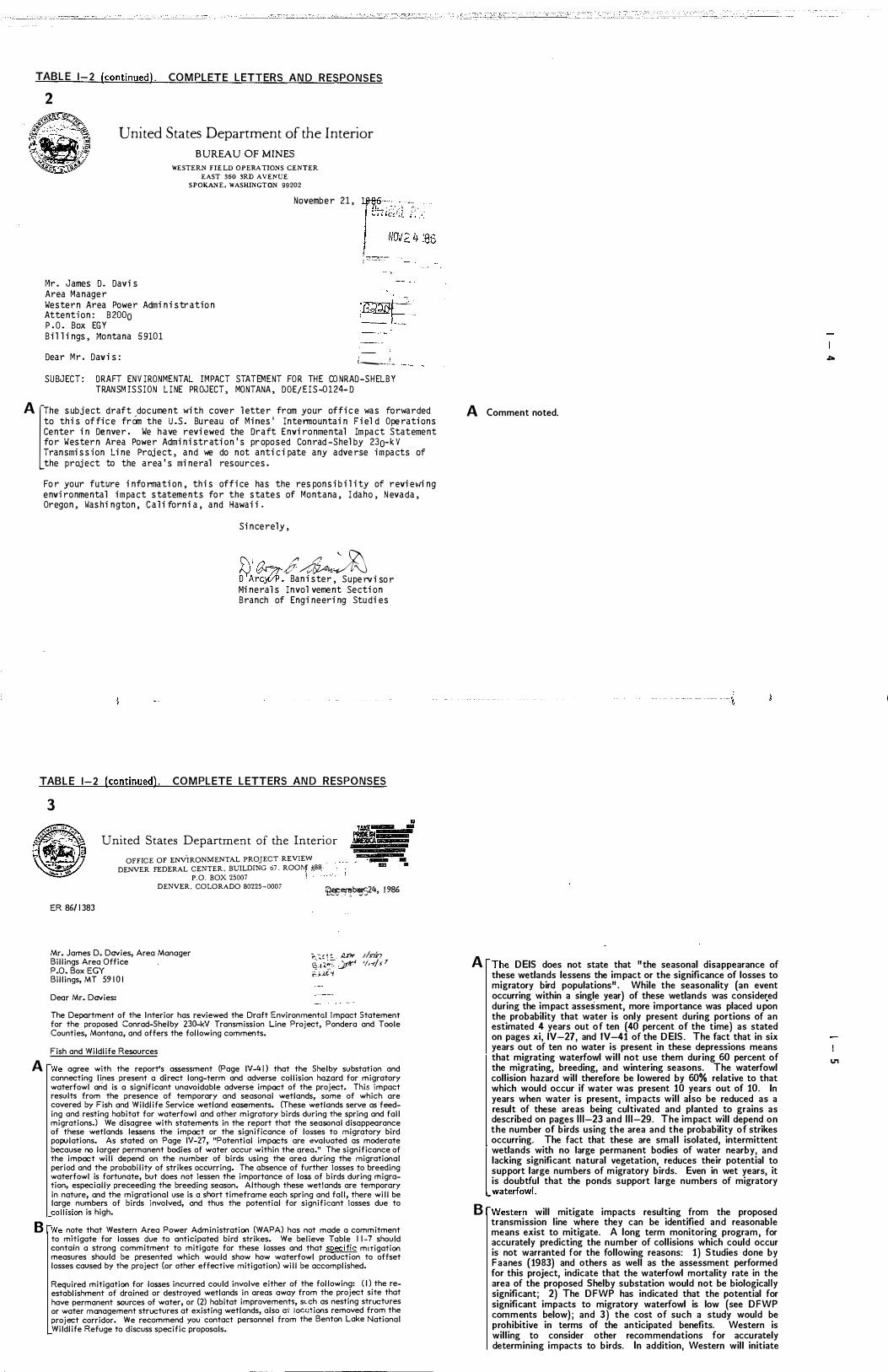
TABLE 1-2 (continued) . COMPLETE LETTERS AND RESPONSES
2
United States Department of the Interior BUREAU OF MINES
Mr. James D. Davis Area Manager
WESTERN FIELD OPERATIONS CENTER EAST 360 3RD A VENUE
SPOKANE. WASHINGTON 99202
November 21, �?-::�; :: -;.:.: ! '"'.:�:; �'86 � 7j::?,�,:,,'-.
Western Area Power Administration Attention: B2000 �Rd� ·-==- L-P .O. Box EGY Bil lings, Montana 59101
Dear Mr. Davi s: t ____ .�_ SUBJECT: DRAFT ENVIRON MENTAL I MPACT STATEMENT FOR THE CONRAD-S HELBY
TRANSMISSION L I NE PROJECT, MONTANA, DOE/EIS-0124-D
A [The sub ject draf t odocu ment with cover letter from your of fice was forwarded to this of fice from the U.S. Bureau of Mines' Intermountain Fiel d Operations Center in Denver. We have reviewed the Draft Environmental Impact Statement for Western Area Power Administration's proposed Conrad-Shelby 230-kV Transmission Line Project, and we do not anticipate any adverse impacts of the project to the area's mineral resources.
For your fu ture infonnation, this of fice has the responsibility of revie�ling environmental impact statements for the states of Montana, I daho, N evada, Oregon, 11ashington, C ali forni a, and Hawaii.
Sincerely,
� �I ./1 /' N ?':��. D A� Banister, Supervi sor �linerals Invol vement Section Branch of Engi neeri ng Stu di es
A Comment noted.
I \
TABLE 1-2 (continued). COMPLETE LETTERS AND RESPONSES
3
United States Department of the Interior OFFICE OF ENVIRONMENTAL PROJECT REVIEW
DENVER FEDERAL CENTER. BUILDING 67. ROOtlf *88 . P.O, BOX 25007 � ,
DENVER, COLORADO 80225-0007 :e�erTb�24, 1986
ER 86/1383
Mr. James D. Davies, Area Manager Billings Area Office P.O. Box EGY Billings, MT 59101
Dear Mr. Davies:
��!!!. �nf J/S-lf'7 5",":; � 'i,-(/,7 ';D.C�
The Department of the Interior has reviewed the Draft Environmental Impact Statement for the proposed Conrad-Shelby 230-kV Transmission Line Project, Pondera and Toole Counties, Montana, and offers the following comments.
Fish and Wildlife Resources
A fWe agree with the report's assessment (Page IV-40 that the Shelby substation and connecting lines present a direct long-term and adverse collision hazard for migratory waterfowl arid is a significant unavoidable adverse impact of the project. This impact results from the presence of temporary and seasonal wetlands, some of which are covered by Fish and Wildlife Service wetland easements. (These wetlands serve as feeding and resting habitat for waterfowl and other migratory birds during the spring and fall migrations.) We disagree with statements in the report that the seasonal disappearance of these wetlands lessens the impact or the significance of losses to migratory bird populations. As stated on Page IV-27, "Potential impacts are evaluated as moderate because no larger permanent bodies of water occur within the area." The significance of the impact will depend on the number of birds using the area during the migrational period and the probability of strikes occurring. The absence of further losses to breeding waterfowl is fortunate, but does not lessen the importance of loss of birds during migration, especially preceeding the breeding season. Although these wetlands are temporary in nature, and the migrational use is a short timeframe each spring and fall, there will be large numbers of birds involved, and thus the potential for significant losses due to ,collision is high.
B fWe note that Western Area Power Administration (WAPA) has not made a commitment to mitigate for losses due to anticipated bird strikes. We believe Table 11-7 should contain a strong commitment to mitigate for these losses and that specific miTigation measures should be presented which would show how waterfowl production to offset losses caused by the project (or other effective mitigation) will be accomplished.
Required mitigation for losses incurred could involve either of the following: (Il the reestablishment of drained or destroyed wetlands in areas away from the project site that have permanent sources of water, or (2) habitat improvements, sLch as nesting structures or water management structures at existing wetlands, also ai' iocc.:tions removed from the project corridor. We recommend you contact personnel from the Benton Lake National Wildlife Refuge to discuss specific proposals.
A rThe DEIS does not state that lithe seasonal disappearance of these wetlands lessens the impact or the significance of losses to migratory bird populationsll• While the seasonality (an event occurring within a single year) of these wetlands was conside�ed during the impact assessment, more importance was placed upon the probability that water is only present during portions of an estimated 4 years out of ten (40 percent of the time) as stated on pages xi, IV-27, and lV-41 of the DEIS. The fact that in six years out of ten no water is present in these depressions means that migrating waterfowl will not use them during 60 percent of the migrating, breeding, and wintering seasons. The waterfowl collision hazard will therefore be lowered by 60% relative to that which would occur if water was present 10 years out of 10. In years when water is present, impacts will also be reduced as a result of these areas being cultivated and planted to grains as described on pages 1 1 1-23 and 1 1 1-29. The impact will depend on the number of birds using the area and the probability of strikes occurring. The fact that these are small isolated, intermittent wetlands with no large permanent bodies of water nearby, and lacking significant natural vegetation, reduces their potential to support large numbers of migratory birds. Even in wet years, it is doubtful that the ponds support large numbers of migratory
_waterfowl.
B rWestern will mitigate impacts resulting from the proposed transmission line where they can be identified and reasonable means exist to mitigate. A long term monitoring program, for accurately predicting the number of collisions which could occur is not warranted for the following reasons: 1) Studies done by Faanes (1983) and others as well as the assessment performed for this project, indicate that the waterfowl mortality rate in the area of the proposed Shelby substation would not be biologically significant; 2) The DFWP has indicated that the potential for significant impacts to migratory waterfowl is low (see DFWP comments below); and 3) the cost of such a study would be prohibitive in terms of the anticipated benefits. Western is willing to consider other recommendations for accurately determining impacts to birds. In addition, Western will initiate
.;..
U1
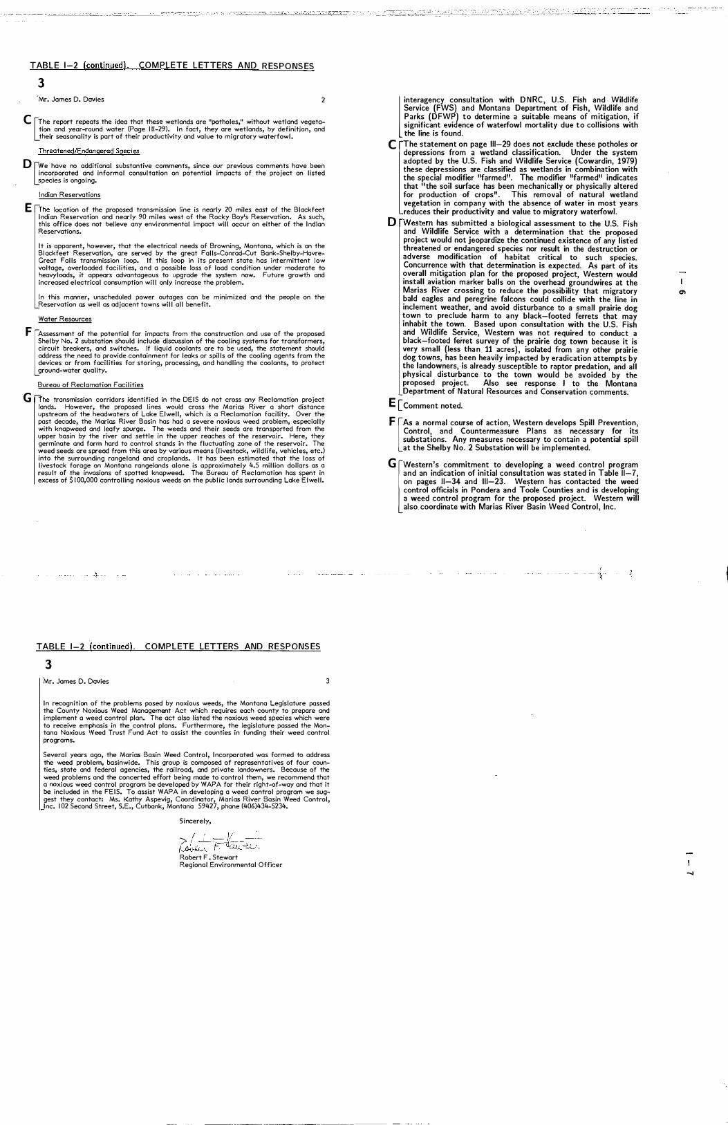
TABLE 1 -2 (continued) . COM PLETE LETTERS AND R ESPO NS ES
3 'Mr. James D. Davies 2
C UThe report repeats the idea that these wetlands are "potholes," without wetland vegetation and year-round water (Page 111-29). In fact, they are wetlands, by definition, and their seasonality is part of their productivity and value to migratory waterfowl.
Threatened/Endangered Species
o �we have no additional substantive comments, since our previous comments have been inco�po�ated a
.nd informal consultation on potential impacts of the project on listed
Species IS ongoing.
Indian Reservations
E rThe location of the proposed transmission line is nearly 20 miles east of the Blackfeet Indian Reservation and nearly 90 miles west of the Rocky Boy's Reservation. As such, this office does not believe any envi ronmental impact will occur on either of the Indian Reservations.
It is apparent, however, that the electrical needs of Browning, Montana, which is on the Bl ackfeet Reservation, are served by the great Falls-Conrad-Cut Bank-Shelby-HavreGreat Falls transmission loop. If this loop in its present state has i ntermittent low voltage, overloaded facilities, and a possible loss of load condition under moderate to heavy loads, it appears advantageous to upgrade the system now. Future growth and increased electrical consumption will only increase the problem.
In this manner, unscheduled power outages can be minimized and the people on the Reservation as well as adjacent towns will all benefit.
Water Resources
F [Assessment of the potential for impacts from the construction and use of the proposed Shelby No. 2 substation should include discussion of the cooling systems for transformers, circuit breakers, and switches. If liquid coolants are to be used, the statement should address the need to provide containment for leaks or spills of the cooling agents from the devices or from facilities for storing, processing, and handling the coolants, to protect ground-water quality.
Bureau of Reclamation Facilities
G [The transmission corridors identified in the DEIS do not cross any Reclamation project lands. However, the proposed lines would cross the Marias River a short distance upstream of the headwaters of Lake Elwell, which is a Reclamation facility. Over the past decade, the Marias River Basin has had a severe noxious weed problem, especially with knapweed and leafy spurge. The weeds and their seeds are transported from the upper basin by the river and settle in the upper reaches of the reservoir. Here, they germinate and form hard to control stands in the fluctuating zone of the reservoir. The weed seeds are spread from this area by various means (livestock, wildlife, vehicles, etc.) into the surrounding rangeland and croplands. It has been estimated that the loss of livestock forage on Montana rangelands alone is approximately 4.5 million dollars as a result of the invasions of spotted knapweed. The Bureau of Reclamation has spent in excess of $ 1 00,000 controlling noxious weeds on the public lands surrounding Lake Elwell.
l interagency consultation with DNRC, U.S. Fish and Wildlife Service (FWS) and Montana Department of Fish, Wildlife and Parks (DFWP to determine a suitable means of mitigation, i f significant eViJence of waterfowl mortality due to collisions with the line is found.
C fThe statement on page 111-29 does not exclude these potholes or depressions from a wetland classification. Under the system adopted by the U.S. Fish and Wildlife Service (Cowardin, 1979) these depressions are classified as wetlands in combination with the special modifier IIfarmedll. The modifier IIfarmedll indicates that lithe soil surface has been mechanically or physically altered for production of cropsll . This removal of natural wetland vegetation in company with the absence of water in most years reduces their productivity and value to migratory waterfowl.
o rWestern has submitted a biological assessment to the U.S. Fish and Wildlife Service with a determination that the proposed project would not jeopardize the continued existence of any listed threatened or endangered species nor result in the destruction or adverse modification of habitat critical to such species. Concurrence with that determination is expected. As part of its overall mitigation plan for the proposed project, Western would install aviation marker balls on the overhead groundwires at the Marias River crossing to reduce the possibility that migratory bald eagles and peregrine falcons could collide with the line in inclement weather, and avoid disturbance to a small prairie dog town to preclude harm to any black-footed ferrets that may inhabit the town. Based upon consultation with the U.S. Fish and Wildlife Service, Western was not required to conduct a black-footed ferret survey of the prairie dog town because it is very small (less than . 11 acres), isolated from any other prairie dog towns, has been heavily impacted by eradication attempts by the landowners, is already susceptible to raptor predation, and all physical disturbance to the town would be avoided by the proposed project. Also see response I to the Montana Department of Natural Resources and Conservation comments.
E [Comment noted.
F [AS a normal course of action, Western develops Spill Prevention, Control, and Countermeasure Plans as necessary for its substations. Any measures necessary to contain a potential spill at the Shelby No. 2 Substation will be implemented.
G [western's commitment to developing a weed control program and an indication of initial consultation was stated in Table 11-7, on pages 11-34 and 111-23. Western has contacted the weed control officials in Pondera and Toole Counties and is developing a weed control program for the proposed project. Western will also. coordinate with Marias River Basin Weed Control, Inc.
� {
TABLE 1-2 '(continued). COMPLETE LETTERS AND RESPONS ES
3 ·Mr. James D. Davies 3
In recognition of the problems posed by noxious weeds, the Montana Legislature possed the County Noxious Weed Management Act which requires each county to prepare and implement a weed control plan. The act also listed the noxious weed species which were to receive emphasis in the control plans. Furthermore, the legislature passed the Montana Noxious 'Need Trust Fund Act to assist the counties in funding their weed control programs.
Several years ago, the Marias Basin Weed Control, Incorporated was formed to address the weed problem, basinwide. This group is composed of representatives of four counties, state and federal agencies, the railroad, and private landowners. Because of the weed problems and the concerted effort being made to control them, we recommend that a noxious weed control program be developed by WAPA for their right-of-way and that it be included in the FEIS. To assist WAPA in developing a weed control program we suggest they contact: Ms. Kathy Aspevig, Coordinator, Marias River Basin Weed Control, Inc. 102 Second Street, S.E., Cutbank, Montana 59427, phane (406)434-5234.
Sincerely,
> ( ' - 1/ _·0-
il;J�� f�:lu. �, Robert F . Stewart Regional Environmental Officer
en
-..a
_J

TABLE 1-2 (continued). COMPLETE LETTERS AN D R ESPONS ES
4 �,��"'�!�.��;,J' �'.
�<' II�i .) U.S. Department of Housing and Urban Development
Denver Regional Office. Region VII I Executive Tower
"�4" Ol �I,.�<l' 1 405 Curtis Street Denver. Coloraao 80202-2349
I c . , . ' - : \ utE 3 '86
December 3 , 1986
Mr. James D . Davies Area Manager Western Area Power Admi n i strati on P . O. Box EGY
$Bro� "Z-j8 . J3);.Jo.</
B i l l i ng s , MT 591 01 -t-Dear Mr. Dav i e s :
Th i s i s i n response t o you r Novembe r 4 , 1 986 , l etter reque sti n g comments o n the Draft Envi ronmental Impact Statement ( DE IS ) for the Conrad-Shel by 230-KV Transmi s s i on Li ne P roject i n Pondera and Tool e Counti e s , Montana.
� l You r DEIS ( preferred route ) has been revi ewed for the a reas o f respon s i bi l i ty assfgned t o the Department of Hou s i n g and Urba n Devel opment. Th i s review consi dered the p roposal ' s impacts on urban i zed areas , and wi th i n these parameters , we fi nd thi s document adequate fo r our purpose.
If we may be of further assi stance , pl ease contact Mr. Myron Eckbe rg , Envi ronmental Speci al i s t, at (303 ) 844-31 02.
- �
Si ncerel y ,
Robert J . Natu schek Di rector Office of Commu n i ty
Pl ann i ng and Devel opment
TABLE 1-2 (continued) . COM PLETE LETTERS AND R ESPONSES
5 �
o U.S. Department of Transportation Federal Avtatlon Administration
DEC 2 1986
Mr. J ames D. Dav i es, Area Manager Western Area Power Adm i n i strat i on P . O. Box EGY B I I I I ng, Montana 591 0 1
Dear Mr. Dav i e s :
Northwest Mountain Region Colorado. t daho. Montana. Oregon. Utah. WashIngton. WyomIng
17900 PacIfIc Htgl1way Soutl"l r�- '--" I '�s�ore"waShlng!On 98168
(ife 5 '86
�;t:{/)� 1:1./5-M-<tY _.
� ITe have rev i ewed your draft e nv i ronmenta l I m pact statement on the proposed Conrad-S h e l by Transm i ss i on L I ne Proj ect and do not foresee a ny I m pact on av i at i on or I ts act i v i t i es.
B CP l ease b e a dv i sed of the Federa l Av i at i on Regu l at i on Part 77 req u i rement to f i l e FAA Form 7 46 0- 1 bef ore beg i n n i n g construct i on .
Th ank y o u for the o p portun i ty t o comment o n your proposed proJ ect.
S I ncer e l y,
!!�J/I7Y>� Kenneth Thomasson Act i n g Po l I cy and P l a n n i ng Off i cer
� Comment noted.
\ t
� Comment noted.
B [Western is aware of this requirement and will file a FAA Form 7460-1 prior to beginning construction.
IX)
10

TABLE 1-2 (continued) _ COMPLETE LETTERS AND RESPONSES
5 8
�J u.s. Department of Transportation Federal Aviation Administration
N o v e Q b e r 2 4 , 1 9 8 6
M r . J am e s D . D a v i e s A r e a t1 a n a g e r D ep a r tm e n t o f E n e r g y W e s t e r n A r e a P ow e r Ad m i n i s t r a t i o n P . O . B o x EGY B i l l i n � s , Mo n t a n a 5 9 1 0 1
D e a r M r . D a v i e s i
A i r p o r t s D i s t r i c t O f f i c e FAA Bu i l d i n g , R o o m 2 H e l e n a R e g i o n a l A i r p o r t H e l e n a , M o n t a n a 5 9 6 0 1
r------ ··--- -o " !.-,, ... ,.� '' ' -- , ' ; 1 tla r�t�;=.f.. r ;i� t �\, t ;
I NOV 2 6 '�6 I . , . I
-: -:"UlR!Joc:L� ______ . • .... ,'* � ...
- -:r::J ----- ->-" .... ."
_-�-"T"-- 1
--
:.
-
.
.
--
--,
£a@ ; , ;------ '
H -�-=:-! --'�
T h a n k y o u f o r t h e o p p o r tu n i t y to r e v i ew t h e D E I S f o r t h e p r o p o s e d C o n r a d- S h e l b Y 2 3 0 kV T r a n sm i s s i o n L i n e P r o j ec t , M o n t a n a D O E / E I S -0 1 24-D .
A [o u r r e c o r d s d o n o t i n d i c a t e t h a t t h e p r o p o s e d d e v e l o p m e n t h a s b e en r e v i ew e d f r om a n a i r s p a c e p e r s p e c t i v e . H e h a v e e n c l o s ed a c o p y o f F A A F o r m 7 4 6 0 - 1 , N o t i c e o f P r o p o s e d C o n s t r u c t i o n . P l a n n e d d e v e l o p m e n t r e q u i r i n g f i l i n g i s i d e n t i f i e d o n t h e f r o n t p a g e . -
P l ea s e c a l l me a t ( 4 0 6 ) 4 4 9 - 5 2 30 i f y o u ha v e a n y q u e s t i o n s .
S i n c e r e l y ,
b::£� P l a n n i n g / P r o g r a m O f f i c e r
1 E n c l o s u r e
�
TABLE 1-2 (continued) . COMP LETE LETTERS AND RESPONSES
6 United States Region 8, Mont3na Office Environmental Protection Federal Building Agency 301 S. Park, Drawer 10Q96
Helena. Montana 59626-0096
�EPA REF: 8MO
December 20 , 1 986
Mr. James D. Davi es Western Area Power Admi ni strati on Attenti o n : B2000 P. O. Box EGY Bi l l i ngs , Montana 591 01
Dear Mr. Davi e s :
�:�tJ 2 187
D.:3tn'!t' Ll1Y f5Jiif,-/
Under authori ty of Section 309 of the Cl ean Ai r Act we have revi ewed your Agency ' s Draft Envi ronmental Impact Statement ( DE I S ) for the Conrad-Shel by Transmi ssi on L i n e .
A U The statement and attached maps i ndi cate there wi l l be mi nor encroachment or i mpact upon wetl and areas . We request that efforts be made to mi nimi ze these i mpacts and that unavoidably l ost wetl ands wi l l be mi ti gated.
E3 U We do not bel i eve the acti vities descri bed in the DEIS wi l l vi ol ate any EPA envi ronmental standards . According to EPA ' s system for rati ng draft impact statements , thi s DEIS i s rated LO ( Lack of Obj ecti ons ) .
I f you have any questi ons or concern s , pl ease cal l Di ck Montgomery at 449-5486 in Hel ena.
f1 s���/ /UCM�
d 1 1 Di r� F War e , John • Office Montana
/)s/i?
See comment B above
\ J
A [NO wetlands would be lost due to the proposed project_ No fi l l materia l would be deposited in wetlands (see response A to the Office of Environmental Project Review comments).
8 [Comment noted.
to
tt-
TABLE 1-2 (continued) . COMPLETE LETTERS AND RESPONSES
7 IfDIITlNA �I ';" " ; " l
- � �. _ i::: .� ' ... ' �411111.:$: I !,�/
MONTA NA BUREA U O F MINES AND G EOLOG Y MONTANA COLLEGE OF MINERAL SCIENCE AND TECHNOLOGY
BUTTE. MONTANA 59701 4061496·4180
fl,t,cE.\'Jt.O Olflce of the Otrector
D t. C. 1 ri \C\9-'--
TO :
FROM :
SUBJECT :
MEMORANDUM
Decembe r 1 5 , 1 9 8 6
?"\ 0 1 nK\\}'i'·�\. �on"\ . "?t: " ca�SS:'" �:I\O\\
\\'i.'SCl,jR\.·t.S "
Wayne A . We tz e l , Ch i e f , Fa c i t i ty S i t ing Bureau Depa r tmen t of Na tura l R e s o u r c e s and C on s e rva t i on 1 5 20 Ea s t S i x th He lena , MT 5 9 6 20
Edward T . Rupp� l , D i r ��o r , Mon tana �ureau o f M in e s and G e o l o gy f l ' � .. �. ��-
c...t:. . . [: '.:..-' / .-," " "'-- --.-'. C.\�. _ .. -
DEIS , Conrad - Shelby Transmission Line Proj e c �
A t tached a re commen ts from Bu reau s c i en t i s ts fam i l ia r w i t h the a rea .
Conrad - She l by Transm i s s i on L ine
Commen ts on Ear th R e s o u r c e s p. 1 1 1- 14 to 1 1 1 - 1 7 and IV p . 2 1 - 22
)\ �he s e c t i on on Ea r th R e s ources covers the ge o l o gy p re t ty we l l . A
B m in o r p o i n t - they c i te our M in i ng D i re c tory a s a s ou r c e of i n f o rma t i on tha t "no me ta l m ine ra l " in the s tudy a rea . Lack of en tr i e s d o e sn ' t rea l ly in d i ca te n o me ta l s . A l s o , I won d e r i f the i r s tra t i c: gra p h i c column i s n ' t rea l ly mod i f i e d f r om B i l l Cobban ' s P r o fe s s i ona l P a p e r 974 . D � gue s s a DEIS d o e sn ' t have to l ook a t h a z a rd s . I wou l d b e very s u rp r i s e d if there a re n o t many land s l i d e s deve l o p e d on the Kevin Membe r .
�
TABLE 1-2 (continued) . COMPLETE LETTERS AND RESPONS ES
7 Conrad - She lby Tran smi s s i on L ine
Comments on Ea r th R e s ources p . 1 1 1 - 1 4 to 1 1 1 - 1 7 and IV p . 2 1 - 2 2
E I The DEIS correc t l y s ta ces tha t the p r imary s ource o f re g i ona l s e i sm i c i ty is the In termoun tain S e i s m i c B e l t to the wes t . H ow e ve r , the report fa i l s t o men t i on tha t s i gn i f i can t ea r thquakes have been loca ted 10 km w e s t of the s tudy a rea C S E o f Cu tbank ) and 30 km e a s t of the s tudy a rea . A t l e a s t s i x ea r thquakes . ha ve been l oca ted w i thin SO km of the s tudy area . It appears tha t the NOAA hypocen t e r da ta f i l e was never s e a r ch e d f o r this r e g i on and Mon tana Bureau of M i n e s a n d G e o l o gy Mem o i r 51 was n o t check e d . The p o ten t ia l ly a c t i ve fau l ts and s e i sm i c ha z a r d s of t h i s re g i on are vi r tua l ly unknown thu s making th e record o f h i s tor i c s e i sm i c i ty an imp o r tan t c lue to p o ten t ia l s e i s m i c haza rds .
Conra d - She lby Transm i s s i on L ine
Commen ts on Ea r th R e s ources p. 1 1 1 - 14 to 1 1 1- 1 7 and IV p . 2 1 -22
F Uo s i gn i f i ca n t comments from Hyd rol ogy D i vi s i on - a p p e a rs t o b e very gene ra l - very few refe rences c i te d ; bu t p robab ly a d e q ua te for the DEI S .
)\ Comment noted .
B [Within the boundaries of the study area , no mining of metal minerals or metal minerals of economic value a re known to exist.
c: [The following sources (provided in Appendix B of the D EIS) were used to develop the stratigraphic column in Figure 1 1 1-4: Cobban, W.W, et ai , 1976 and Holmes, K.H. , and T .E. Bretz, 1951.
o [SlOpe stability (slumping potential) was an integral part of the geologic hazard and geologic impact assessment process as described on pages IV-20 and IV-21, Table IV-2 (page IV-23) , and Table 1 1-6, page 7 of 9.
\ ) ,
E rAccording to the literature (Montana Bureau of Mines and Geology Memoir 51) , the seismic events recorded in the proximity of the Cut Bank area registered an intensity of 3, a value similar to vibration caused by passing of light trucks. The first minor damage associated with seismic loading occurs 2 orders of magnitude higher than the events recorded at Cut Bank (ie. 20 times the loading). Therefore, these events a re of minor significance for the purpose of constructing a transmission line. However, it should be noted that potential hazards related to seismic events may exist as a result of the geologic conditions present in the area. In the event that there is a reoccurrence of seismic activity, small scale landslides (slumping) may occur in _areas of poor slope stability.
F Comment noted.
� I'.J
.... w
TABLE 1-2 (continued). C O M P L ETE LETTERS A N D R ES P O N S ES
8 A
I DEPARTMENT OF COMMERCE
TED SCI-iWINDEN. GOVERNOR 14.24 9TH AVEKUF
��E OF MON�NA ---------(406) 444-3494 HELENA MOK7Al'A 59620 0<::':
D e c e m b e r 1 0 , 1 9 8 6
W a y n e W e t z e l , C h i e f , F a c i l i t y S i t i n g B u r e a u
D e p a r t m e n t o f N a t u r a l R e s o u r c e s
A n d C o n s e r v a t i o n
� � e E j V E D { ' l- r; I J 108G
MC)NUNA DEPT. OF NATURAl R[SOUilCES & CONSERVATION 1 5 2 0 E a s t S i x t h A v e n u e
H e l e n a , M o n t a n a 5 9 6 2 0
D e a r M r . \,l e t z e l :
I n r e s p o n s e t o y o u r l e t t e r o f D e c e m b e r 9 , 1 9 8 6 I a m f o r � a r d i n g
, y o u a c o p y o f o u r a g e n c y ' s c o m m e n t s � i t h r e s p e c t t o t h e D r a f t
E n v i r o n m e n t a l I m p a c t S t a t e m e n t f o r t h e C o n r a d - S h e l b y T r a n s m i s s i o n
L i n e P r o j e c t . - T h e s e c o m m e n t s h a v e p r e v i o u s l y b e e n s e n t t o t h e
A r e a M a n a g e r o f t h e \,l e s t e r n A r e a P o � e r A d m i n i s t r a t i o n a s n o t e d o n
t h e a t t a c h e d c o r r e s p o n d e n c e .
E n c l o s u r e :
�
Y o u r s T r u l y ,
.&..-�c:7 �A'f R i c h a r d A . H o � e l l , M a n a g e r
S p e c i a l P r o j e c t s T r a n s p o r t a t i o n D i v i s i o n
-/
TAB L E 1 - 2 (continued). C O M PL ETE L ETTER S AND R ES P O N SES
A
8
c
8 8 DEPARTMENT OF COMMERCE
TED SCHWINDEN', GOVERNOR e�;-=�ii i·1�� 142� AVENUE 1It."'-' � STATE OF MONTANA --. � ,_, _�. I '(I)IG 'S6 , .:. __ '"" ,
HEU:NA, MONTANA 59620-0401 ::;:JU��.;n: .-
-
N o v e m b e r 7 , 1 9 8 6 ,'--- -, -,,":
-
A r e a M a n a g e r '�J?_J?!_ , ,,(,,;> ;1-'U""_:�tL ' ''j" !&3.'e> I:g::._. ;,-, /11_
W e s t e rn A r e a P ow e r A d m i n i s t r a t i o n A t t n : B 2 0 0 0
P . O . B o x E G Y B i l l i n g s , M o n t a n a 5 9 1 0 1
.1_ . ""_ Ji5-'2�" i ! -"""� L..=..:..l=:=-' -1 f __ __ .J
S u b j e c t : C o n r a d - S h e l b y T r a n s m i s s i o n L i n e P r o j e c t M o n t a n a DE I S
D e a r M r . D a v i e s :
T h e T r a n s p o r t a t i o n D i v i s i o n o f t h e M o n t a n a D e p a r t m e n t o f C o mm e r c e c o n d u c t e d a r e v i e w o f t h e s u b j e c t p r o j e c t D E I S . O u r c o mm e n t s r e s u l t i n g f r om t h i s r e v i ew a r e p r e s e n t e d a s f o l l o ws :
� • T h e c r o s s i n g s p r o p o s e d i n t h e p r e f e r r e d a l t e r n a t i v e w o u l d a p p e a r t o a c c o mm o d a t e r a i l o p e r a t i o n s i f t h e y a r e b u i l t t o a c c e p t e d s t a n d a r d s .
2 . P r o b l em s w i t h s h o r t w a v e r a d i o r e c e p t i o n m a y n e e d mi t i g a t i o n .
W i t h r e s p e c t t o t h e s e c o n c e r ns i t i s i m p e r a t i v e t h a t s u f f i c i e n t h e i g h t a n d wi d t h c l e a r a n c e s b e m a i n t a i n e d . �T h e r a i l l i n e i n q u e s t i o n b e t w e e n C o n r a d a n d S h e l b y i s an a c t i v e B u r l i n g t o n N o r t h e r n ma i n l i n e p r o j e c t e d t o g r o w i n v o l um e u s e . A b a n d o n me n t i s � c o n s i d e r e d l i k e l y i n t h e n e a r f u t u r e .
T h a n k y o u f o r t h i s o p p o r t u n i t y t o c o mm e n t .
Y o u r s T ru l y ,
�d � R i c h a r d A . H o w e l l , M a n a g e r S p e c i a l P r o j e c t s T r a n s p o r t a t i o p D i v i s i o n
A [western constructs its transmission lines to meet or exceed N ational Electric Safety Code standards. The proposed transmission line crossing will accommodate a l l normal rail operations.
8 Uf complaints of shortwave or other radio or television interference are received, they will be resolved by Western, as indicated on page IV-32 of the DEIS.
C Comment noted
..... �
..... I.TI

TABLE 1-2 (continued). COM PLETE LETTERS AND RESPON� "" -
9 cM°llJarta �1IJ
of PisIt,'Wddlife ® �
D e c e m b e r 2 2 , 1 9 8 6 1 4 2 0 E a s t 6 t h A v e n u e H e l e n a , M T 5 9 6 2 0
M r . Wa y n e W e t z e l F a c i l i t y S i t i n g B u r e a u D e p t . o f N a t u r a l R e s o u r c e s
a n d C o n s e r v a t i o n 1 5 2 0 Ea s t 6 t h A v e n u e H e l e n a , M T 5 9 6 2 0
D e a r Wa y n e :
E n c l o s e d a r e s o m e c o m m e n t s o n t h e W A P A C o n r a d - S h e l b y T r a n s m i s s i o n L i n e E I S . T h e y w e r e p r e p a r e d b y G a r y O l s o n , o u r � i l d l i f e B i o l o g i s t i n t h e a r e a .
I n g e n e r a l , t h e E I S i s r a t h e r w e a k i n i t s d e s c r i p t i o n o f w i l d l i f e u s e i n t h e a r e a a n d t h e i m p a c t s s e c t i o n i s t o o g e n e r i c t o g i v e a p i c t u r e o f t h e s p e c i f i c i m p a c t s t o b e e x p e c t e d .
T h a n k y o u f o r t h e o p p o r t u n i t y t o c o m m e n t .
S i n c e r e l y ,
� UJo1/ ,2. /TC-"-' LU.,c -<-/77
R R M / b f s
E n c l o s u r e
',,=
R o b e r t R . Ma r t i n k a R e s o u r c e A s s e s s m e n t
TABLE 1-2 (continued). COMPLETE LETTERS AND RESPONSES
9 1 2 / 1 8 / 86
T O : Bob Ma r t i n ka FROM : Gary O l s o n RE : WAPA C o n r ad - S h e l by T r an sm i ss i o n L i n e P r o j e c t
� II met w i t h WAPA peop l e and S c o t t M c C o l l ou g h ( DNR ) on December 1 1 i n S h e l by ; w e s p e n t most of t h e mo r n i n g l ook i n g at v ar i ou s s i t es a l on g t h e p r o j e c t l i n e . F r om w h at I h ave 5ee n � t he re are f e w measu r ab l e i m p a c t s t o w i l d l i f e a s a r e su l t of t h i s p r oj e c t . T h e p r oposed l i ne d o es n o t c r oss a n y c r i t i c a l r i p ar i an o r b r e a k s h ab i t at , and t h e p o t h o l e area n o r t h of t h e Mar i as R i ve r i s wet o n l y part of the t i me . W h e n t h e p o t h o l es are wet I d o u b t w h e t h e r t h ey c o n t r i bu t e m u c h i n t h e way o f g o o d wate r f o w l h ab i t at , s i n c e t h e en t i r e a r e a i s i n t e n s i ve l y f armed , a n d l i t l e d e nse n e s t i n g cover ex i st s .
B [l: had n o t rev i ewed t h e E I S p r i o r to t h e f i e l d t r i p . T h e r e a r e s o m e i t ems t h at need t o be c l ea n ed up i n t h e d o c um e n t , however . If I h ad read t h e E I S and n o t i n sp e c t e d t h e a c t u a l s i t e I wou l d have a n e n t i r e l y d i f f e r e n t at t i tude about t h i s p r o j e c t . For i n s t an c e , mu l e deer a r e n ' t me n t i o n e d as one of t he typ i c a l res i de n t s of g r ass l an d h ab i t a t s ( 1 1 1 - 23 ) and t he r e f e r e n ces used in t h i s sect i on are most l y very s k e t c h y . A n examp l e wou l d b e t h e
d i scuss i o n o f b i g game i n I I I - 2� . T h e r ef e r e n c e used i s an e x e r p t f r om D e e r of No r t h Amer i c a ; I wou l d t h i n k t h i s i s a b i t b r oad f o r a spec i f i c r e f e r e n c e t o t h e Mar i as R i ve r i n M o n t an a . T h e same was
_d o n e f o r w h i t e t a i l and a n t e l op e .
C IT h e d i s c u ss i o n o f u p l an d game b i r d s i n 1 1 1 - 25 wou l d l e ad me - t o b e l i eve t h at t h ose p o pu l at i o n s ex i s t o n l y because o f p l an t s of game f arm b i r d s eac h year . T h i S , 0+ course , i s not the c as e . I n t h e sec t i o n o n f u r bear e r s ( 1 1 1 - 2 6 ) t h e y aga i n , h ave used a v e r y ge n e r a l re+ e r e n c e and make n o m e n t i o n 0+ m i n k o r beave r . T h e d i sc us s i on of t h e p r e f e r red r o u t e i n 1 1 1 - 26 m e n t i o n s d i f f e r e n t w i l d l i + e h ab i tat s � i n c l ud i n g w i n t e r r an g es , b u t 9 i ve s t h e r e ad e r n o c l ue as t o t h e sour c e .
[) � n t h e en v i r o n me n t a l c o n s e que n c es sec t i o n ( I V - 2 6 ) var i ou s i mp a c t s t o w i l d l i + e are d i s c ussed . I c an � t d e t e r m i neout w h e t h e r or n o t t he r e w i l l be a n y i mp a c t s t o var i ous w i l d l f e s p e c i es based o n t h e i r d i scuss i o n of p o t e n t i a l ef f e c t s . T hey d o n ' t c ome o u t and say o n e way o r the o t h e r ; t oo many " wease l " w o r d s !
I n g e n e r a l , I wou l d say t h at � h i s d o c u m e n t n ee d s to be t i g h t e n ed up i n t he w i l d l i + e s e c t i o n s to be 0+ muc h v a l ue T o r s om e o n e read i n g i t t h at h as n o t seen t h e s t u d y a r e a . T h e re+ e r e n ces used a r e e i t h er muc h t o o b r o ad Tor the s p e c i + i c s 0+ a p ow e r l i n e c o r r i d o r o r t hey are n o t m e n � i o n e d at a l l . T h e r e ad e r n e e d s t o b e ab l e t o f r om an op i n i o n about p r oj e c t ef f e c t s o n w i l d l i f e and I f ou n d t h i s very d i f f i cu l t t o d o .
\. .J
� Comment noted.
B I The species identified in the discussion on page 1 1 1-23 of the D EIS under Grassland is a partial list intended to familiarize the reader with the habitat type present in the study area. Mule deer, whitetail deer, and antelope are discussed in greater detail in the appropriate section under Big Game on page 1 1 1-25.
The references cited in the D EIS include a literature search of available material and interviews with agency personnel familiar with the area. These references are listed in Appendix B.
C I The discussion on page 111-25 of the D EIS was not meant to imply that new introductions of upland game occur each year. The intent of the statement was to convey the fact that pheasant and gray partridge were introduced to the region a number of years ago and are associated with grain farming in the area.
Although mink and beaver were not noted in the study area during field investigations, these species are known to exist in the region.
Data regarding seasonal distribution of wildlife was obtained from maps on file at the Montana Department of Fish, Wildlife, and Parks office in Great Falls.
[) nmpacts to big game, upland game, and fur bearers are expected to be low and short-term in nature. These impacts would occur during the construction phase of the project, as indicated on page IV-26 in the D EIS. I nitial impacts to State species of special concern are expected to be moderate and long-term. Implementation of mitigation measures listed in Table 11-7 would reduced initial moderate impacts to low residual impacts, as stated on page IV-27. Impacts to migratory species are addressed in response A and B to the Office of Environmental Project Review and response J to the D N RC.
'""" 0'1
'""" -...

TABLE 1-2 (continued). COM PLETE LETTERS AND RESPONSES
l O A DEPARTM ENT OF H EALTH A N D ENVIRONM ENTAL SCI EN CES
ENVIRONMENTAL SCIENCES DIVISION
TEDSCHWt!"'l.:O!:N GOVERNOR COGSWELL. BUIL.OI .... G
- STATE OF MONTANA "06 )/J1.�j(� 444-3948
December 1 1 . 1 986
HEL.EI'>.I.. MC-"':TANA59620
RECEIVED
D E C 1 1 lQ>iS U""NT. Drrj of NAj l, " ';l
·CES :. ;:. ... ;::::1V ... � J .:.J Kev i n Hart . Speci a l Projects Coordi nator Faci l i ty S i t i n g Bureau DNRC Hel ena . MT 59601
Dear Kevi n :
RE : No Response from WAPA on DHES Rev i ew of the Shel by to Con rad 230 kV Transmi s s i on Li ne
Encl osed is a copy of the DHES revi ew of the Western Area Power Admi ni strati on ' s (WAPA) p re l i m;'r.ary d raft envi ronmental impact statement wh i c h was made l a st s umme r . A rev i ew of the draft £ I S does not show that the water qual i ty and hazardous wa s te q ue s t i o n s were answered i n the d e ta i l requested by the depa rtment. Sol i d waste con s i derati ons were mentioned under construction ( i tem # 1 0 - Cl ea nup and Remova l : p a g e 1 1 - 1 8 ) . but only i n a p a s s i ng refere n c e .
T� ena b l e the D H E S to comp l y w i t h i ts ma n d a ted duti e s . WAPA needs to a n swer the req uested i n forma t i o n . I f t h e WAPA peop l e want to deal d i rectly wi t h Abe Horpesta d . Water Qua l i ty Bureau (444-240 6 ) and Vi c An ders e n , Sol i d a n d Hazardous waste Bureau ( 444-2821 ) they c a n , o r they c a n contact me .
j g
Enc l o s u re
--.-�';
ncerely,
lO W<-'�omas M. El l erhoff
Tec h n i c a l Wri ter
TABLE . 1-2 (contin ued) . COMP LETE LETTERS AND RESPONSES
l O B DEPARTMENT OF HEALTH AND ENVIRONMENTAL SCIENCES
COGSWELl.. BUILDING
-- STATE OF MC)NTAt\jA 44';- 39�8 Hn.EN"., MON'TANA 59620
J u l y 1 0 , 1 986
Kevi n H a c " Spec i a l Proj ects Coord i na to r F a c i 1 ; t y Si ti ng Bureau DNRC Hel ena , MT 59601
Dear Kevi n :
RE: Rev i ew of Conrad to She l by 230 kV T r a n smi s s i on L i n e Prel i mi nary D E I S
T h e Western A r e a P o w e r Admi n i stration ' s ( WAPA) prel i mi n a ry d raft envi ronmenta l impact statement for the c o n s tructi o n of a 230 kV transmi s s i on l i n e between Conrad a n d S he l by was revi ewed by t h e Water Qual i ty ( \.iQB ) , Ai r Qu a l i ty (AQB) and Sol i d a nd Hazardous Waste ( SH,IB) bureaus .
The fol l owi ng comments were made con cern i ng the envi ronmental h e a l th a s pects of the p l a n :
A I Water Dua l i ty - The p l a n men t i o n s that the preferred route c rosses the 11a r i a s R i ver a nd the Dry Fork of the Mari a s River, in a d d i t i o n to one p e re n n i a l stream, Pondera Cou l ee a nd 13 ephemeral s t reams . The W a t e r Qu a l i ty Bureau n eeds to know the names of a l l the peren n i a l and e p hemeral streams that wou l d be crossed in a l l the routes , preferred and a l te rn a tes . The bureau a l s o needs t o know if construction acti vi ty wi l l tempora ri l y a l t er wa ter q u a l i ty a n d , if s o , determi ne i f WAPA wi l l need to a p p l y for a s ho rt term exemp t i o n to a l ter water q u a l i ty s tandards ( S h o r t Term Exemp t i o n from Water Qu a l i ty Sta n d a rds fDr Constructi o n
Acti v i ty - ARI·I 1 6 . 20 . 633 ( 3 ) ) .
Ai r Dua l i ty - Reference the encl osed l etter from Warren N o rto n .
Sol i d a nd Hazardous Wa s te - Reference the enc l o sed memo from V i c Ander s e n .
I f WAPA o r Goodson and ASooc i a te s , I n c . have a ny q u es t i o n s or cc::-ments conce rni n g the Depa rtment o f Hea l th a n d E n v i ronme n t a l Sci ences re V l e w , have them c a l l me (444-3948) o r Abe Horpes t a d , WQB , (444-2406 ) ,
Wa rren liorton, AQB . ( 444-3454) or Vi c Anders e n , SHfI B . ( 444-282" ,
S i n c e re l y ,
Thomas M. E l l erhoff Techn i c a l Wri ter
A iWestern wil l provide DHES a list of perennial and intermittent (ephemeral) streams crossed by the transmission line as soon as a route is fina lized, and apply for a short-term exemption to alter water quality standards, if necessary. Short-term minor turbidity c')uld result from the movement of construction vehicles through srnal l waterways. Neither wheeled nor tracked vehicles would be al lowed to enter major waterways, such as the Marias and Dry Fork Marias Rivers. Western wi l l coordinate with the Montana Department of N atural Resources and Conservation (D N RC ) to develop project-specific environmental stipulations (see response "M" to D N RC comments) which wi l l include measures to protect a l l water bodies which may be crossed by the proposed transmission line.
.... CO
.... 10

TABLE 1-2 (continued) . COMPLETE LETTERS AND RESPONSES 1 0 C
Office Memortmdum • STATE DEPARTMENT OF HEALTH AND ENVIRO N M ENTAL SCIENCES
TO
FRO ...
Tom E l l erhoff
Vi c Andersen ttJ. DATE : J u l y 3 , 1 986
SUBJECT : Conrad-She l by 230 kV L i ne
13 �o mention is made of s o l i d waste or hazardous wa ste hand l i ng or disposa l . The only reference to waste ma nagement I fou n d was i n the a i r section where they proposed burni n g a l l debri s . I d o n ' t know what p l ans they ' ve made for wastes . They need t o a ddress t h i s matter " a nd i n c l ude a section i n t h e contra ctor req u i rements , wh i c h I wou l d l i ke to s e e i nc l uded i n the E I S .
TABLE 1-2 (continued) . COMPLETE LETTERS AND RESPONSES 1 1
DEPARTM ENT OF H I G H WAYS
TEDSCHWI"JDEN GOvERNOR 2701 �ROSF�CT
�NE OF MON�NA ---------
December 1 6 , 1986
Wayne Wetz el , Ch i e f Faci l i ty Si t i ng Bureau Depa rtment of Natural Resources
and Conserv a t i o n He l ena , M T 59620
CONRAD-SHELBY TRANSM I S S I O N L I N E DRAFT ENV I RONM ENTAL IMPACT STATEMENTS
I-IELE r-..;I. MO .... TAr-..A SS620
R E C E I V E D D E C 1 0 1986
MONTANA DEPT OF NATURAL RESOURCES & CONSERVATION
Thank you for the o p portu n i ty to rev i ew the above c a p t i oned D E I S .
� �h e Montana Department of H i g hways recommends that a l l towers be con structed we l l away from pu b l i c roads so that they do not c o n s t i tute a hazard for out of control veh i c l e s . On a contro l l ed access h i g hway , s u c h a s I n terstate 1 5 , p rov i s i on s for constru c t i o n and mai nte nance a c c es s shou l d be coord i nated through the DOH Great Fal l s D i stri ct Offi ce .
Qou are adv i sed to obta i n a Standard R i g h t -of-Way E n c ro a c hment Perm i t (RW-20 ) for a ny a e r i a l road cro s s i ng s or p u b l i c road a c c e s s routes . These perm i ts are avai l a b l e from the DOH Great Fa l l s Di s t ri ct Offi c e . � t i s understood that t h e contractor w i l l u s e adequate s i g n i ng at pub l i c road accesses during construc t i o n . I t i s a l s o understood t h a t the contra c to r wi l l not exceed rated l oad l i mi ts o n any s tructure o r roa d segment d u r i n g construct i on o r s u bsequent mai ntenance .
If you need a d d i t i o n a l i nforma t i o n , p l ea s e c o n t a c t th i s offi c e .
4�� DON CROMER , SUPERVI SOR RURAL PLAN N I NG SECTION
DC : SS : mb : 2( k k
c c : Keenan B i n g ham Thomas Barnard Homer Whee l er
S t e v e Ko 1 0g i B i l l Dunb a r , FHWA
13 1 The D EIS clearly states on page IV-20: "Western does not anticipate any open burning, and if so, not enough to require a state permit. II
Under "Cleanup and Removal " on page 11-18 of the D EIS, it is stated: II All rubbish and waste material would be hauled away and disposed of at approved sites. II It is not anticipated that any hazardous wastes will be generated during project construction. If so, they will be handled like waste generated at al l other Western facilities, in accordance with a l l applicable State and Federal laws and regulations.
A All towers will be located outside of pubic road rights-of-way.
B [western is aware of this requirement. As in past projects, Western will coordinate with the Montana Department of Highways and obtain a permit.
C �western's construction specifications require contractors to provide adequate signing and comply with al l road load limits and/or overload vehicle permitting requirements.
� I-"
� o
TABLE 1-2 (continued) . COMP LETE L ETTERS AND RESPONSES
1 2 DEPARTMENT OF NATURAL RESOURCES
AND CONSERVATION
TED SCKWINDEN. GOVERNOR
STATE OF MONTANA DIRECTOR'S OFFlCE (406) ",,,,,.66!X1
J ames D. Dav I es, Area Ma nager Western Area Power Adm I n I strat I on B I I l I n gs Area Off I ce P. O. Box EGY
-
B I l l l n gs, MT 591 0 1
Dea r Mr. Dav I es :
December 23 , 1 986
1520 EAST SIXTH AV'D'lUE
\ :., � ��A: i.!ONTANA 5�6:Z0 : ,- _0 2 d, I S8a i � " �,.': .-: �" '-:' t." ,:.=1 c.'�'"
,,/ ." :,.. �.r .... " '�" :�·:;- I
\:' ;:��!' : �,. ":=r:-i2·:..j ,.8:1.<><= !.�.' u./.,,1/F� �.B,2:4.a1)_.; ___ � •• _ . _ _ _ �
-" ._--;---'
--.---: �=:�--.�--j T h e Depa rtment of Natur a l Resources and Conserv at I on (DN RC ) s ubm I ts t h e
f o l l ow I n g comments o n t h e Western Area Power A dm I n I stra t I on (Western ) Draft Env I ronmenta l Impact Statement for the Conra d-to- S h e l by 23 0-kV Transm I s s I o n L I ne Project (DOE/E I S 0 1 240 ) .
It I s our hope that th I s l etter and the specI f I c comments r e l atI ng to econom I c a n a l ys i s a n d reso urce I mpa cts from the proposed project be I ncor porated I n i'h e I r ent I rety I n th e f I na I E I S . Some comments may req u I re Western to gather' a d d I tI o n a l I nformatI on to e na b l e DNRC a n d the Department of Hea l th and E nv I ronmenta l ScI ences (DHES) to determ I ne w heth er th e proposed Conrad-Sh e l by project comp i l es w I th state env I ronment a l l aw s .
DNRC a l so I s forw ard I ng comments f rom other state age n c I es. A s l ea d a gency, DNRC I nten ds t o a dopt Wester n ' s draft E I S, a s s u p p l ementep a n d ame n d e d b y th e state ' s comments, as th e state ' s dr aft E I S for th I s project . We w I I I be m a I l I n g our comments a n d a notI ce of a dopt i o n of Wester n ' s E I S to the p u b l I c for rev I ew I n J anuary . Our f I na l decI s I on on w hether . . to a do pt Wester n ' s f I na l E I S as o u r f i na l E I S w I I I depend on the a d equacy of Wester n ' s responses to th e concerns and I nformat i on req uests expressed I n th e atta ched comments. Our f i n a l E I S wo u l d a l so need to a d dress comments rece ive d f rom the p u b l I c I n response to our J a nuary E I S so l i c i tat i on .
S u b sequent t o the E I S process, DNRC w i l l I ss ue a re port t o t h e Board of Natur a l Resources and Conservati on a d dress i ng a ny concerns th at rema i n u nreso l ved a n d w l l I make re comme n da t i ons a s to wheth er Wester n ' s project wo u l d comp l y w i th esta b l i sh e d state sta n dards un der th e Major Fa c i l ity S i t i ng Act.
TABLE 1-2 (continued). COMP LETE L ETTERS AND RESPONSES
1 2 Page 2 December 23 , 1 986
I f you h av e any q uest i ons r ega r d I n g th I s mater i a l , we wou l d be g l ad to meet w i th perso n n e l from Wester n . Th a n k you I n a dvance f or your con s l dera t l on of our concerns.
KJH/ jb Encs .
A I Conme nt :
�:r��y , •
Va n J am l s Adm l n l st tor E nergy D l v l s l o n
State of �nta na Comme nts on th e
Co nr a d to S h e l by Draft E nv l rorme nta l Im pa ct S tateme n t
A N ,Al YS I S OF N EED FOR TH E PROJ E CT
Th e gl ossary o f t h e draft E IS sh oul d conta l n t w o a d d l tl o na l d e f i n l t i ons to
hel p rea ders un dersta n d the d i scuss i on co nta l ne d i n Ol a pter s One an d Tw o. The
def I nl t i ons a r e :
L i ne L osse s : E l ectr i c power r eq u i red to ov ercome resi sta nce i n a
tran sm i s s i on system, meas ured by the d i f f erence betwe e n the amo u nt of power
generate d and t h e amount of power de l i v ered to cust om er s .
Prese nt W orth : AI so knOo' n a s prese nt v a l ue or d i s co u nte d v a l ue. The val ue
to day of a SLill of money expected to be earne d or pa I d i n the f uture. Th i s
v a l ue r ef l ects the I ntere st cost of del ay I ng rece i pts a n d al 1 000s compari son of
v a l ue s at dl fferent t i mes.
A Comment noted.
r-,) r-,)
r-,) (,0.)

TAB LE 1-2 (continued). COMP LETE LETTERS AND R ESPONSES 12
B I Canme nt :
Eval uatl ons of both pr i v ate i nv estm ents a n d f ederal proj ects gener a l l y
I n c l u de a canpar i so n of the be nef i ts a n d th e costs. [;N R C has pr ev i o us l y
I n d i cated t o W estern t h at I nf ormat i on a bo ut both th e benet Its and costs of a
project a n d the un certa i nty of those be nef i t s a n d co sts i s v i ta l to Wester n ' s
de ci s i on process a n d the exp l a na t i o n of de c i s i ons through an E I S . DNRC f ee l s
that a n a l y s i s of costs and be n ef i t s I s e s se nti a l to sa t i sfy th e r eq u i r eme nt s of
the Nati ona l Env i rormenta l Pol i cy Act a n d the /ob nta na Env i rormenta l Pol i cy Act.
Western presents Its "econan l c a n a l y s i s " of the proposed proj e ct an d three
a l ter nati ves on pa ges 1 1-6 and 1 1-7 and i n Ta b l e 1 1- 1 on pa ge 1 1- 1 2 . DN RC
con s i ders th i s a n a l y s i s i n can p l ete a n d co nf u s i ng. The a n a l y s i s doe s not
co n s i der the m a i n so urces of be nef I ts of e i th er the proposed proj e ct or i ts
a l terna t ives. I t treats I I ne l os se s as a cost of the project whe n a r e d u ct i on
i n l i n e l os se s I s o ne of the benef i t s of the project. I t al so i n c l u des th e
cost of rebu i I di ng the Hav re-Shel by 1 1 5-kY tr a n 911 I ssi on I I ne I n proj ect costs
when th a t l i ne i s not part of the project un der con s i derati o n . The res u l t i s
a n overstatement of the costs of th e project a n d i ts a l ternati v e s w i th no
statement of th e l � be n ef i t s. Th i s prov i de s no ba s i s for can par l n g the proposed
proj ect w i th the no-act i on a l terna t i v e and o n l y a n I ncom p l ete ba s i s f or
canpar l so n of th e f o ur opti ons co n s l dere d .
i n de c l d i n g w hether t h e proposed project can p l I es w i th t h e substant i v e
prOV i s i on s of th e I-bntana Major Fac l l i ty S i t i n g Act, th e B oar d o f Nat ur al
Resour ce s a n d Conserv ati on i s req u i red to con s i der both I ts be nef Its and
costs. [;NRC th erefore co n d u cte d a n a n a l y s i s of the benef i ts a n d costs of th e
proposed proj ect a n d a l ternat l v es. [;N RC f o u n d that th e benef Its of Wester n ' s
propose d Co nrad-Sh e l by 230-kY tran sm i s s i o n l i ne are reaso na b l y I I ke l y to excee d
th e costs a n d that I t I s the l ow est cost opt i on that w o u l d so l ve the area ' s
e l ectr i ca l pro b l ems. DNR C a gree s that Wester n ' s proposed act i o n I s the best
opt I on. The reasons f or th I s ch o l ce m ust be presented to the p u b l I c.
TAB LE 1 - 2 (continued) . COMPLETE LETTERS AND R ESPONSES
12 E CONOMI C AN AL YS I S O F THE PROPOSED A Cf I ON AN D AL TERN AT I Y ES
An e co nom i c a na l y s i s of the benef I ts a n d costs of a proposed proj ect sh ow s
whether, fran soci e ty ' s v i ew p o I nt, th e be n ef I ts a r e l I ke l y to e xceed th e costs
and the r I sks are acce ptab l e . The actual benef I ts of the proposed project w I l l
de pen d on both f ut ure e l ectr I c i ty deman d an d th e f ut ure serv i ce I nter r u pt i o n s
that the proj ect w o u l d protect aga I nst. The I i m i te d amount of i nf ormat I o n
av a I l a b l e t o estimate f ut ure el ectr I Ci ty dema n d a n d the costs o f tra n sm I ss i o n
prob l ems a d ds a n e l ement of uncerta I nty . Faced w i th th i s potent I a l for
un certa I n ty, [;NRC' s econan i c a n a l y s I s focused on determ i n i n g th e l ev e l of
conf I de nce w I th w h i ch I t can be s a i d that th e benef Its of th e proj ect w i l l be
greater tha n I ts costs. [;NRC f o u n d the r i s k aSSOCi ate d w I th the costs be i n g
greater th a n the benef i ts I s sm a l l ( DNRC 1 985 ; DNRC 1 986c ) .
Opt i ons Exam i ne d
the [;NRC estI mated the pos s l bl e ranges of benef I ts a n d costs f or each of
o pt I ons con s l dered I n Ta b l e 1 1- 1 . A ny e st Imat I o n of be n ef Its a n d costs
DN RC used the no-act I o n a l ternati ve as req u i res a base I I ne f or can par I son .
th i s basel I ne, a n d the be n ef I t s a n d co sts I n can par I son t o n o act I o n w ere
com p uted f or each al ter natI v e . The uncerta i nty of the be ne f Its i s ref l ecte d I n
the r a n ge of pos s I b l e v a l ues prese nted for each ty pe of be n ef I t.
B enef I ts of the Opt I ons
Any of the f o ur con str uct i on opt I ons w o u l d benef I t e l ectr i c i ty co ns um er s by
prev e nt I n g or del ay i n g th e dr amati C deter i ora t I o n of serv i ce r e i l a b i l i ty that
w o u l d be exper i enced by custaners i n the B row n I ng-Cut B a n k-Sh e l by area i f no
a cti o n were ta ke n .
u tl i i ty rel i a b i l I ty cr I ter i a ge neral l y req u i re that a transm i ss ' �n sy stem
be a b l e to se rv e a l l l oads eve n w I th a ny s i ngi e tran 911 I s s i o n i i ne o ut of
serv i ce . Th e Brow n i ng-Cut B a nk-Sh e l by area ca n bare i y meet th i s cr i ter i on a t
present. L o a d f l ow stu d i es performed b y Western a n d r ev i ewed by [;N R C' s
e l ectr i ca l e n g i nee r i n g contractor sh ow that by 1 990 an D utage on th e exi sti n g
1 1 5-kY I i ne f r om Co nr a d to Cut Ban k d ur i n g a h i gh l OG e per i o d wo u l d res u l t i n
unacceptabl y l ow v o l tage and l oss of power to some consLiTlers I n th e
Brow n i ng-Cut Bank-Sh e l by area. Later I n th e 1 990s a n o uta ge on tne
B I Council on Environmental Quality " Regulations for Implementing the Procedural Provisions of the National Policy Act" (40 CFR 1500-1508) do not require the preparation of a cost-benefit analysis as part of the Federal environmental process. Section 1502.23 of the regulations provides in pertinent part, that " For the purposes of complying with the Act, the weighing of the merits and drawbacks of the various alternatives need not be displayed in a monetary cost-benefit analysis and should not be when there are important qualitative considerations. In any event, an environmental im pact statement should at least indicate those considerations, including factors not related to environmental quality, which are likely to be relevant and impo.rtant to a decision. " Western has contractual agreements with its customers and other power suppliers in the region to maintain a particular level of reliability of service. As described in the D EIS, joint studies by area utilities i ndicated the need for system improvements in the Conrad-Cut Bank-Shelby area in order to meet those reliability requirements. Several alternatives were evaluated which could provide the necessary level of reliability. Based upon the electrical and economic factors used in the studies, and reported in the D EIS, the proposed action was the best to meet the long-term needs of the area. A cost/benefit analysis as conceived by D N R C is not required by Western for its decision making process, therefore, was not included in the D EIS.
N �
N <J1

TABLE 1-2 (continued) . COM PLETE LETTERS AND RESPONSES
12 Havre-Shel by 1 1 5-kV l i ne w o u l d cause s i m i l ar prob l ems, a n d t h e prob l em s w o u l d
cont i n ue to worsen as power demand grow s i n th e area ( Western 1 985 ; DNRC
1 986 a ) . I f no ch anges were made i n area ' s transm i ss i o n system, customers co u l d
expect to exper i e n ce more o uta ge s I n th e f uture th a n they do to day.
Engi neer i n g r ei i ab i l l ty cr i ter i a co u l d be v i o l ated I n a n area w her e l oads
are so sm a l i or o uta ge s are so I nfreq uent that the oost of mee t i n g the
engl neer l ng rei l a b l i i ty req u l rement I s greater th an the benef i ts. Pu b l i c
i nvestment projects m ust norm a l l y meet certa i n eoo n om i c sta n dards be s i des th e
rei ev ant engi neer l ng r eq u l rements. Th e proposed proj ect shoul d not be a n
exce pt i o n . S pe c l f i ca l i y, the pro posed project sho u l d be e xan l ne d to determ i ne
whether i ts benef i t s w o u l d be greater th a n I ts oosts an d whether i t i s th e best
o pt i on. S i nce the be nef I ts are uncerta l n, it i s a p propr i ate to eval uate the
r i s ks i nvol ve d i n m a k i n g th e I nvestme nt.
/Io nta na ' s s ubsta nt i v e sta ndards f or need a n d m i n i m um adverse I m pact for a
tra n sm i ss i o n l i ne r eq u i re that three tests be met. Fi rst, th ere m ust be a
prob l em that w l l i be sol ved I n a t i me l y manner by the proposed I i ne. I f no
act i o n I s take n, the ut i l i ty ' s r e l l a b l i I ty cr i ter i a w o u l d be v l oi ate d w i th i n 2
y ears of the date ' the proposed f ac i l i ty i s to be p l aced I n serv i ce (ARM
36 .7 .3506 (7) ( a ) ) . Seoo n d , th e be nef i ts of the project m ust exceed I ts oosts.
Th e vai ue of red u ce d o utages and i mpr ov e d r ei i a b l I I ty over th e l i f e of the l i ne
m ust be reasona b l y l i ke l y to e xcee d the oost of the l i ne ( ARM 36 . 7 .3 506
( 7 ) ( b ) ) . Th i r d, the proposai must be be tter th an a ny reasona b l e a l ternati ve.
The o pt i o n chosen m ust h ave th e l owest oost of the o p t i o n s tha t wo u l d sa tl sfy
th e f i rst two req u i rements.
Any of the four oon str uct i on o pt i ons w o u l d prov i de be nef i ts. They wo u l d
prevent or s l ow the deter i or a t i o n of serv i ce r el i a b i l i ty by ena b l i n g the system
to oo nt l n ue to s u p p l y power at acce pta b l e vol ta ge s ev e n w i th one tr a n sm i ssi on
l i ne o ut of serv i ce. Th i s wo u l d be n ef i t el ectr i ci ty customers by red u c i n g the
n um ber , durati on, a n d costs of outa ge s a n d by i ncr ea s i n g the certa i nty of th e i r
ei ectr l c l ty s up p l y . Th e tr a n sm i ss i o n a l ter na t i v e s w o u l d del i v er power over new
transm i s s i o n I i ne s w i th h i gh er ca pa c i ty a n d l ow er res i sta nce th a n exi sti n g
l i nes. Th i s woul d r e d u ce th e ano u nt of power l ost i n overcom i n g th e r e s i stance
I n th e l i ne a n d w o u l d m ake th i s a d d i t i o na l power av a l I abi e to oonsumers.
� �....- - - -� .. - -�- ---� -
TABLE 1-2 (continued). COM PLETE LETTERS AND RESPONSES
1 2 Re duct i o n i n f uture outage oosts
Any of the f o ur constr uct i on opt I ons w o u l d prov I de be nef I ts by reduci ng the
oosts that wo u l d be i m pose d o n customers by tran sm l s s i on system fai l ures.
These oosts I ncrease w i th the tota l amount of t i me w i th o ut serv i ce and w i th
l on g I n d i v i d u a l o uta ge s . Greater dema n d f or power I n th e f ut ur e w i l l I n crease
the cost of outa ge s . None of the opt i ons w o u l d protect oonsumers aga i nst
system-w i de o utages or f a l l ures of l ocal d i str i b uti o n l i ne s.
The proposed Cb nrad-Sh el by 230-kV l i ne wo u l d pr ov i de r ei l a b l e tran sm i s s i o n
serv i ce to t h e B ra.. n i ng-Cut B a nk-Shel by area unt i I w e i I after 1 996 . Bey o n d
th i s po i nt, i t w o u l d n o l on ger prov i de f ul l serv i ce i n s om e o utage s i t ua t i ons
but w o u l d st l I I prov i de benef Its.
The a d d i t i on of ca pa C i tor s at the Shel by and R u dy ar d s ubsta ti ons woul d
m a i nta i n tr an sm i s s i o n rei l a b i l f ty i n the area o n l y through a bo ut 1 996 . Th i s
opt i on w o u l d soi ve th e rei l ab i I i ty prob l em for a shorter per i od than th e other
o pti ons an d wo u l d prov I de a p proxlmate l y 35 per ce nt of the be nef I t s estimated
f or the Co nr a d-Shel by I I ne .
Both the Co nr a d-Cut B a n k a n d Havre-Shel by o pt i ons w o u l d prov I de f ul I
serv i ce I n the f a ce of si n g l e tr an sm i s s i o n l i ne o uta ge s th rough 1 9 96, but
rei i a b l i I ty woul d beg l n to deter i or ate soon af ter that date. E i th er of these
o pt i on s wo u l d prov i de more be nef i ts a n d a l on ger l a sti n g sol uti o n to the
rei i a bi I ity pro b l em th an the a d d i ti on of ca paci tor s at S h e l by a n d R u dy ard.
However, th ey woul d sol ve the pro b l em for a shorter t i me an d w i th f ewer
be nef its th an th e Co nr a d-She l by o pt i o n .
Outages : Pr ec i se data on l oca l outa ge s was not av a i i a b l e f rom Western,
al though data represe ntati ve of outa ge s f rom a I arger area were sup p l i e d .
Western s up p l i e d a n d CI'l R C used data comp i l ed by the Ml d- Cbnt l ne n t Ared Power
Pool to e sti mate how often customers i n th e B ra.. n i ng-Cut B a nk-Shel by area w o u l d
exper i e n ce o utages of d i f f erent l e n gths d ue to tra n sm i s s i o n f a l l ures I f the
present system were l ef t una l tered C DN R C 1 986 b ) . Cons umers w o u l d exper i e nce
a d d i t i o na l o utages a n d oosts d ue to system-w i de f a i l ure�, a n d d i str i b u t i o n
f a l I ures. However, on l y o uta ge s on the area tr a n sm i ss i o n sy stem, w h i ch w o u l d
be arne I l orated by the pro posed l i ne, are con s l der e d here. The total amo unt of
t i me that customers m i gh t be w i th out power each y ear due to tr ansm i s s i on
N CI'l
N -.j

TABLE 1-2 (continued) . COMPLETE LETTERS AN D RESPONSES
1 2 f a i l ures a n d th e I i ke l i hood of that total o uta ge t i me occurr i n g i s g i ve n i n
Ta b l e 1 .
TASLE 1 Tota l Annua l Outage T i me
Time Proba b i l i ty 0-24 h o ur s 23 .5%
24-48 hours 1 4 .0% 48-72 ho ur s 1 2 . 8% 72-96 hours 1 1 .0% 96 + ho urs 38 .7%
Ta b l e 2 prov i de s i nf orma t i o n o n the l i ke l i hood of CXlns umers exper i e n c i n g
l on g o uta ge s dur i ng the w i nter. It i n d I cates that, w I th no act i on, CXlns umers
CXl ul d e xpect a n o utage of a t l ea st 1 2 h o ur s i n 3 o ut of 4 year s . Th I s i s the
t I me a n aver a ge r-bntana h ouse woul d take to drop f rom 55 degrees to the
freez i ng poI nt In col d w i nter wea th er.
Durati o n 1 ho ur 6 hour s
1 2 ho urs 24 hour s 48 ho ur s
TASLE 2 W i nter O utage L e ngth
Proba b i l i ty of at I east o ne o utage per � I nter l o n ger than gI v e n duratI o n
97 . 4% 85 . 6% 73 . 2% 53 .6% 28 .7%
O:>sts of o uta ge s :
o uta ge s (DNRC 1 986c ) .
DNRC i de nt i f l e d f our ty pe s of s l gn i f i ca nt costs of power
These are ( l l l ost r es I de nt I a l e l ectr I c serv i ce ; ( 2 )
l o st, del aye d or dama ge d I n d ustr I a l pro duct I o n , ( 3 ) damage i n curred by
resI de nt I a l customers, pr I m ar i l y from f roz e n p I pe s ; a nd ( 4) damage I ncurred by
commercI a l customers, pr I mar I l y from s po i l a ge of r ef r i gerated a n d froze n fOO d .
Actua l outage CXlsts I n a ny year w I I I de pe n d o n th e n um ber o f outa ge s, th e l r
l e n gth and t I m I ng, l oa d gr a.t th , a n d other f a ctor s.
Est I mates of th e val ues resl de ntl a l customers w o u l d pi ace on l ost
e l e ctr i cal serv I ce d ue to th e ran ge of pos s l b l e I n cr ease d o uta ge s w I th n o
I mprovements I n the transm i ss I on sy stem a r e g I v e n I n Ta b l e 3 . ( A l l costs are
pre se nte d I n 1 988 dol l ar s . )
TABLE 1-2 (continued). COM PLETE L ETTERS AN D RESPONSES
12 TASL E 3
Annua l O:>st of I nterr upted ResI de nt I a l Serv i ce i n 1 990*
CDst $0-$ 1 3 0 , 00 0 $ 1 3 0 , 0 00-$50 0 , 0 00 $50 0 ,000-$ 1 ,30 0 , 0 0 0 $ 1 ,3 00 , 000-$2 ,900 ,000 more than $2 , 900 , 0 0 0
Proba b i l i ty 1 0% 25% 3 0% 25% 1 0%
*Th e range of th e se CXlsts wo u l d be grea t l y reduce d I f ho useh o l ds bought a n d use d back-up ge nerator s. Ha.tever, th I s i s un l I ke l y to be w I de sprea d u n l ess total l o st r e s I de ntI a l serv I ce average d at l ea st $2 m I l l I on per y ear.
Est I mates of th e r a nge of poss I b l e l osses i n dustr I a l customers woul d
s u sta I n d ue to I n crease d power f a i l ures I n a year i f no act I o n i s take n are
presented I n Ta b l e 4 .
TASL E 4 A n n ua l V a l ue of I n dustr I a l L osses I n 1 990
CDst $0 $ 1 -$ 1 , 5 0 0 , 000 $ 1 ,500 ,000-$3 , 40 0 , 0 0 0 $3 ,400 , 000-$7,900 , 000 more than $7 , 90 0 , 00
Proba b i I Ity 1 0% 25% 3 0% 25% 1 0%
Res I de ntI a l a n d commercI a l dama ge s wo u l d occur o n l y d ur I n g l o n g o uta ge s a n d
o n l y dur l n g part of the y ear so th e damage I n a ny g I v e n y ear m ay be zero.
Howev er, I n years whe n l on g o uta ge s occur, dama ge can be a p precl a b l e. U n l ess
the transm i s s l o n sy stem I s I m proved, resl de nt l a l damage cou l d be expected to
occur I n 3 o ut of 4 years, and commerci al dama ge CXl u i d be expected I n a bo ut 4
o ut of 1 0 years. I n y ears w i th l on g w i nter o uta ge s, res I de nt I a l damage w o u l d
r a n ge u p�ar d from $4 m i l l I on , an d l on g o utages CXl u l d pro duce commercI a l damage
of u p to $1 m I l I Ion.
Th e actual CXlst of f uture o uta ges Is un certa i n . Howev e r , the severi ty of
o utage CXlsts a n d th e I r proba b l I I t l es of occur r I n g ca n be com b I ne d to g i v e
estImates of th e range of tota l be n ef I t s that CXl u i d be expe cte d f r om av o l d i n g
I ncr ea se d o uta ge s . Ta b l e 5 sh a.t s the proba b l l i t l e$ at (, l f f er ent l ev e l s o f th e
be n ef I ts that m I gh t res u l t from avo I d i n g o uta ge s for 25 years. Th I s I s
eq u i v a l ent to th e benef Its that w o u l d be produced by the O:> nr a d-Sh e l by o pt I on.
N co
N 10
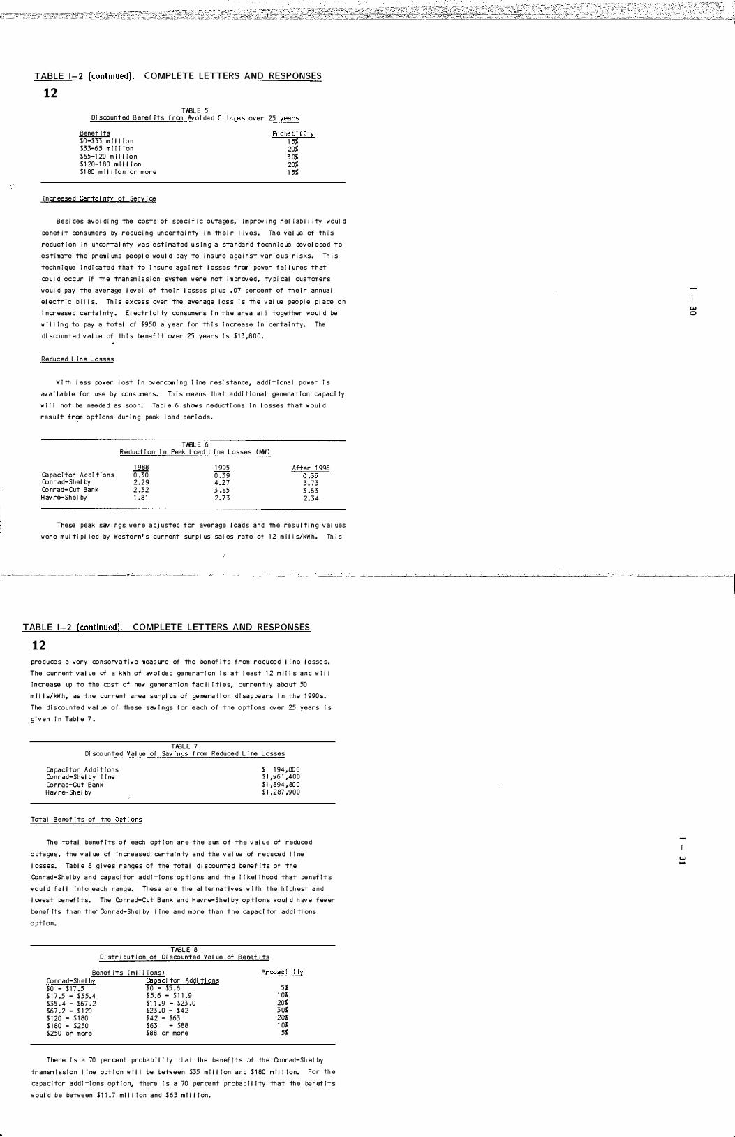
TABLE 1-2 (continued) . COMPLETE LETTERS AND RESPONSES
12 TPBL E 5
OJ scounted B e nef J ts f rom Avo l de d O utages over 25 years
Benef Its $0 -$33 m I l l I o n $33-6 5 m I I I I on $65-1 20 m i l l I o n $ 1 20-1 80 m i l l i on $1 80 m I l l I o n or more
I ncr ease d Certa I nty of Serv i ce
Proba b I l Ity 1 5% 20% 3 0% 20% 1 5%
BesI des av o i d I ng the costs of s pe c i f I c o uta ge s, i m prov I ng rei I ab i l i ty woul d
be nef i t cons umers by r e d u c I n g un certa I nty I n th e I r l I ves. Th e v a l ue of th I s
reduct I o n I n uncerta l nty was e st I mated u s l n g a sta n da r d tech n I q ue dev e l o pe d to
estImate the pr em I ums peopl e wo u l d pay to I ns ure a ga i n st v a r i o us r i s ks . Th i s
tech n I q ue I n d I ca te d that to I nsure aga I nst l osses f rom power f a I l ures t h at
co u l d occur If th e tra n sm I s s I on system w ere not I m pr ov e d, ty p I ca l customers
w o u l d pay the average l ev e l of th e I r l osses p i us . 07 perce nt of th e i r ann ua l
e l ectr I c b i l l s. Th I s excess over the average l os s I s th e v a l ue peo pl e p l a ce o n
I ncr ease d certa i nty . E l ectr i ci ty consumer s I n t h e area a l I together w o u l d be
w i l l I n g to pay a total of $950 a year f or th I s i n crease I n certa i nty. The
d i sco unted v a l ue of th I s be nef I t ov er 25 years I s $ 1 3 , 8 0 0 .
Reduced L i � e L osses
W I th l ess power l ost I n ov ercom I ng I i ne resI sta nce, a d d i t i ona l power I s
av a I l a b l e for use by cons umers. Th i s means th at a d d i t I o na l ge nera t I on ca pa c i ty
w I I I not be nee de d as soo n. Ta b l e 6 s h OW' s r e d uct I ons I n l osses th at w o u l d
res u l t from o ptI ons d ur I n g peak l oa d per I o ds.
TPBL E 6 R e duct I on I n Peak L oa d L i ne Losses ( MW )
1 988 1 995 After 1 996 ca pa c I tor A d d I t I o n s 0 .3 0 0 .3 9 ---0:35 Conrad-Shel by 2 . 2 9 4 . 2 7 3 . 73 Co nrad- Cut Bank 2 .32 3 .85 3 .63 H av re-Shel by 1 . 8 1 2 . 7 3 2 . 3 4
These peak sav i ngs w e r e a dj usted f or average l oa d s a n d th e res u l tI n g v a l ues
w er e m u l ti p l l ed by Weste r n ' s current s ur p l us sa l es rate of 1 2 m i l I s/kW h . Th I s
TABLE 1-2 (continued). COMPLETE L ETTERS AND RESPONSES
12 pro d u ce s a very co n serv a t I v e meas ure of th e be n ef I ts f r om r e d u ce d l I n e l o sse s.
The current v a l ue of a kWh of av o l de d ge nerati on I s at I east 1 2 m l I I s a n d w i l l
I n crease up to the cost of new genera t I o n f a c l l i tl e s, curre ntl y a bo ut 50
m i l l s/ kW h , as th e current area s ur p l us of ge neratI on d I sa p pears i n the 1 990 s.
The d i s co u nte d v a l ue of the se sav I n gs f or each of the o ptI ons over 25 years i s
g I v e n i n Ta b l e 7 .
TPBL E 7 01 sco unte d V a l ue of Sav I ngs f rom Reduce d L i ne L osses
ca pa c i tor A d d i t I ons Conrad-Shel by I I ne Co nrad-Cut Bank H av re- Sh e l by
Total Benef i ts of the OptI ons
$ 1 94 , 80 0 $ 1 ,':J6 1 ,400 $ 1 , 894 , 80 0 $ 1 ,287 ,9 0 0
Th e tota l benef I ts o f each opt I on are t h e s um o f t h e v a l u e of reduce d
o uta ge s , the v a l ue of I n creased car tal n ty a n d the v a l ue of r e d u ce d l I ne
l osses. Ta b l e 8 g i v e s r a nges of the tota l d l scounte d be nef I ts of the
Conrad-Sh e l by a n d ca paci tor a d d i t I o n s o p t I o n s an d th e I I kel i hoo d that be nef I t s
w o u l d f a l l i nto each range. These are the al ter nat l ves w I th the h i gh est a n d
l owest be nef I ts. The Co nrad-Cut B a n k an d H avre-Sh e l b y o p t i o n s wo u l d h av e f ew er
be nef Its th an the· Conrad-Sh e l by l i ne a n d more th a n the ca pac! tor a d d l tl ons
o ptI on.
TPBL E 8 D I str I but I on of DI sco unted V a l ue of B e nef I ts
Benef Its Co nrad-Sh el by $0 - $ 1 7 .5 $ 1 7 .5 - $35.4 $35 . 4 - $67 . 2 $67 . 2 - $ 1 20 $ 1 20 - $ 1 80 $ 1 80 - $250 $250 or more
( m l I I I ons ) Capac! tor Addl tl ons $0 - $5 . 6 $ 5 . 6 - $ 1 1 . 9 $1 1 . 9 - $23 .0 $23 . 0 - $42 $42 - $63 $63 - $88 $88 or more
Proba b I l ity
5% 1 0% 20% 3 0% 20% 1 0%
5%
There I s a 70 per ce nt proba b I l I ty that th e be n ef i TS .)f th e Co nrad-Sh e l by
tr ansm I ss I o n l I ne opt I o n w i l l be betw e e n $35 m I l l I on a n d $ 1 80 m i l l I on. For th e
ca pa ci tor a d d i tI ons o pt I o n, there i s a 70 per ce nt proba b i l i ty that th e be n ef i t s
w o u l d b e between $ 1 1 . 7 m i l l I on a n d $ 6 3 m i l l i on.
II.) -
II.) o
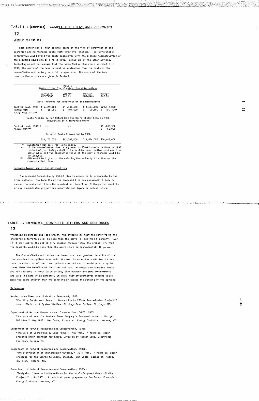
TABLE 1-2 (continued). COMPLETE LETTERS AND RESPONSES
12 Costs of th e Opt i ons
Each o pt i on w o u l d I ncur ca p i ta l costs at the time of constr uct i on and
o pera t i o n a n d m a i nte na n ce co sts (O&M) ov e r I t s l I fetIme. Th e H avr e-Sh e l by
a l terna t I v e w o u l d av o I d the costs assocI ated w I th the p l anned r econstr uct I o n of
the e xI stI n g Havre-Sh e l by l i ne I n 1 996 . S I nce al l of th e other optIons,
i n cl u d I ng no act I on, assume th at the H av re-Shel by l I ne w o u l d be r e b u I l t i n
1 996 , the costs of the re b u i l d m ust be s u btracte d from the costs of the
Havre-She l by o pt I o n to g I ve a f a i r com pa r I so n . Th e co sts of the f o ur
construct I o n o pt I ons are g I ve n I n Ta b l e 9 .
HBl E 9 Costs of th e Fo ur Co n struct i on AI ter natl ves
CAPA C I TOR ADD I T IONS
CONRADSH EL B Y
CONRADQJ T-BAN K
Costs I ncurre d for Constr u ct i o n a n d Ma I nte nan ce
H AVRESHELBY
Ca p I ta l cost, 1 988 An n ua l O &M
$ 1 2,47 9 ,500 $ 1 25 , 90 0
$ 1 1 ,397 , 4 00 $ 1 0 4 , 000
$ 1 3 ,364 , 6 00 $ 1 09 , 50 0
$29, 4 1 1 , 0 0 0 $ 1 5 9 , 7 0 0 "
(3 .5% esca l atl o n )
Costs Avo l de d by Not Reou l l d l n g t h e H av re- S h e l by l i ne i n 1 996 ( H avre-Sh el by A l ter nat i ve On l y )
Ca p i ta l cost, 1 996 "" An n ua l O &M"""
$ 1 1 ,205,500 $ 6 0 , 0 0 0
V a l u e o f Costs 01 sco unted to 1 988
$1 4 , 1 7 0 , 00 0 $1 2 , 7 93 , 000
" S u bstati o n O&M o n l y for H avre-Sh el by
$1 4 , 834 , 0 0 0 $26 , 448 , 0 0 0
"" I f the H av re-Shel by l i ne I s upgrade d to 230-kV spe c i f i ca ti ons I n 1 996 I n stea d of j ust be i n g r e b u i l t, the avo i de d constr u cti on cost wo u l d be $38 , 9 1 5 , 0 00 and the d i sco unted v al ue of th e cost d i f f erence w o u l d be $1 4 ,282 , 6 0 0 .
""" O &M w o u l d be h i gh er on the exi st I ng H av re- Sh e l by l i ne th an o n the reconstru cte d l I n e.
Econom i c Compa r i so n o f the A l terna t i v e s
Th e propo se d Ccnrad-Sh el by 230-kV l i ne I s e conom i ca l l y prefer a b l e t o the
other optI o n s . The be n ef Its of the pro pose d I I ne are reaso na b l y I I ke l y to
e xce e d the costs a n d I t h a s the greatest net benef I ts . A I though the benef i ts
of a ny tran sm I s s i on project are uncerta i n a n d de pe n d on act u a l f ut ur e
TABLE 1-2 (continued). COMPLETE LETTERS AND RESPONSES
12 transm i ss l on outa ge s a n d l oa d gr Olt th , th e proba b i l I ty that the benef I ts o f th e
preferred a l terna t I v e w I l l be l e ss th a n the costs I s l e ss th a n 5 perce nt. Eve n
I f i t onl y so l ves the r e l i ab i l i ty prob l em through 1 996 , th e proba b l l i ty that
the be n ef Its w o u l d be I ess th a n th e co sts wo u l d be a p proxlmate l y 1 0 per ce nt.
The Conrad-Shel by o pt I on has the l ow est cost a n d greatest be nef I ts of the
f o ur construct i o n o pt i o n s exam i ne d . I t s co s t I s m or e th a n a m i I l i on dol l ars
l es s than th e cost of th e other opt i ons exam i ne d a nd I t w o u l d prov i de up t o
three t I mes th e be n ef I t s o f the other o pt l o[l s . A I though e nv I rorme ntal costs
are not I n c l u de d I n these cal c u l atI ons, both Wester n a n d [NRC e nv I ro nme nt a l
a na I y s l s I n d l cate I t i s extremel y u n I I ke I y that env i ro rm e nta I Impacts w o u l d
make the co sts greater tha n the be nef I ts or ch a n ge th e ran k i n g of the optI o n s .
References
Western Area Pow er Adm I n I strat i on (Wester n ) , 1 985 .
" Fa c l l l ty Dev e l o pme nt Report : Co nrad-Sh el by 230-kV Tra n sm I s s i o n Pr oj e ct. "
J une. D i v i s I on of Sy stem Stu d i es, B i l l i ngs Area Off I ce , B i l l i n gs, MT.
Ce partment of Nat ur a l Reso ur ce s a n d Con servati on ( [NRC) , 1 9 85 .
"Ana l y s I s of Need f or Montana Pow er Com pa ny ' s Proposed l a ur e l to B r i dger
' B ' L I ne. " May 1 985 . Da n Dodds, Econom I st, E nergy D I v i s I o n. H e l e n a , MT.
Department of Natur a l Resources a n d Conserv at i on, 1 986 a.
"Ana l y s I s of Co nrad-Sh e l by l oa d F l ow s . " May 1 9 86 . A tech n I ca l paper
prepared u n der contract for Energy D i v i s i on by Ramesh S oo d , E l ectr I ca l
E n g i neer. H e l e na , MT.
Department of Natur a l Reso ur ce s a n d Ccnserv atl on, 1 986 b .
"The D i stri b ut i o n of Tra n sm i s s i o n O utage s . " J u l y 1 9 86 . A tech n I ca l paper
pr epared for the Co nrad to S h e l by project. Da n Do d ds , Econom i st . �nergy
D i v l s l o n. H e l e na, MT.
Department of Natural Reso ur ce s a n d Conserv atI on, 1 986c.
"Ana l y s l s of Nee d an d A I terna t l v e s for Wester n ' s Pro pose d Co nrad-Sh el by
Project. " J u l y 1 986 . A tech n I ca l paper prepare!.l �y Da n Do d ds , Econom I st,
E nergy D l v l s l o n . H e l e na, MT.
(,oJ (,oJ
(,oJ �

TABLE 1 - 2 (continued) . COM PLETE LETTERS AND RESPONSES
12 I DENT I F I CAT I ON, AN AL YS I S, AN D M IT IGAT I ON OF
ENV I R ONr>'ENTAL I MPACTS FROM THE PROJ ECT
C I Canment :
The draft E IS I s unc l ear and m i s l ead i ng I n I ts d i scus s i on of Impacts a n d
m i t i gati o n. Ap pen d i x A, Task 4F, on page A-9 , des cr l bes how m l t l gat l o n was
i de nt i f i e d I n the route se l ect i on process. Ne i ther the m i t i gati on measur e s
al l u de d t o nor the areas where these meas ures w i l l be ta ke n are cl ear l y
descr I be d i n t h e document.
0 1 Canme nt :
Base d on f l el d r ev i ew of th e propose d center l i ne sh ow n i n the dr af t E I S ,
[N R C note d two areas w h er e m i t l ga t l o n f or v i s ual I m pacts sho u l d be con s l der e d .
a ) O p portun i ti es f or i m p l ement i ng sel ect i v e m i t i ga ti o n sh ou l d be exp l ored
f or the re s l de n ce at the cros s l ng of Pon dera Co u l ee ( T28 N , R2W, SI I ,
SW 1 / 4) . Here the proposed center l i ne I s l ocated a p pr oxi mate l y
o ne-te nth m i l e frcm the re s l den ce. O pport u n i ti e s for str ucture
p l acement a n d/or center l i ne adj ustments to red uce v i s ua l impacts shoul d
be expl cr e d o
b ) Groun d d l st ur bance a n d v I s ua l I m pacts co u l d b e r educe d by rei ocatl ng a n
access r oa d east of Led ger ( T2 9 N, R2W, S24, NW1 / 4 ) . R e l o cat i o n frcm
the steep f a ce of th e Dry For k to th e rei at l v e l y fl at bench top south
of th e Ledger Roa d wo u l d acccm pi I sh th I s.
E I Canme nt :
S i nce the max i m um el ectr i C f i el d str e n gth of the pr oposed f ac i l i ty f a l l s
w i th i n th e range re ported by th e l i terature to af fect honey bees, i t ca n not be
categor i ca l l y state d t h at th e f l e i d i s un l i ke l y to h av e adverse eff ects o n a ny
h i ves l ocated beneath th e l i ne. The statement on page I V-35 , paragr a p h 4 a ,
d i rect l y conf l i cts w i th I nf ormat i on prov i de d I n A p pe n d i x D . Th e t e xt shou l d be
rev I se d to r e f l e ct I nrorma t l o n a bo ut po s s l bl e I m pacts on bee h i ves a n d
W e ster n ' s comm i tm e nt t o m i ti gate those I mpacts a s s pe ci f i ed I n Appe n d i x D ,
paragraph 2a.
TABLE 1-2 (continued) . COMPLETE L ETTERS AND RESPONSES
1 2 F lComme nt :
I t I s I mpossi b l e t o determ i ne f rcm the draft E IS w hat the speci f i c i m pacts
to r l parI an vegeta t i o n w I I I be frcm constr u ct I o n of the I I ne. Th e i ni tl a l
prob l em i s t h e l ack o f a cl ear def I n i t i on o f "r i par i an. " Th e v egetati o n
sect i o n refers to Sect i o n H ( Fl oo d p l a i n s an d Wetl a n ds ) . Th e w l l d l l fe sect i o n
refers back to the vegetati o n sect i on. Sect i on H f a i l s to cl ear l y descr i be a n d
def i ne r i par i a n vegetati o n. Th e I ss ue i s f urther co nf used by th e g l ossa ry ' s
def i n i t i on of r i par i an.
The f i na l E IS m ust corr ect th e contra d i ct i ons rega r d i ng i m pacts to r i par i a n
vegeta t i on ( p . 1 1 1 -23 , l i ne 1 5 ; p. 1 1 1 -29 , l i ne s 1 4 a n d 1 5 ; Fi g ur e I V-6 ) . Does
the preferred route cr oss r: par i an v egetati o n ? W o u l d r I par i an v egetati o n ( i . e.
cotto nwoods ) be r em oved ?
G I Comme nt :
Th e b i ol ogi ca l sect i on i s I ncom p l ete w i th rega r d to I nf ormat i o n sources
u se d to descr i be ba sel i ne con d i t i ons. The draft E I S ( p. 1 1 -26 ) states that
I nformatl o n came f rcm "ex l sti ng data so ur ce s w i th s u p p l ementary f lei d
I nvestl gat l ons. " S u b ch a pters I I I -G a n d I I I-H m ust i n cor porate al l l ocal
references. If i nformat i on I s base d o n f i el d st u d i es, th e methodo l ogi es m ust
be br l ef I y des cr i be d . FI g ure 1 1 1 -1 0 m ust sh ow so ur ce s of w I I d l I f e
I nf ormati on. Fi gur e 1 1 1 -9 sh o u l d a l so conta i n I nf ormati o n sources.
H [Canme nt :
It I s not possi b l e to determ i ne f rcm the draft E I S w h at the I m pacts to
wetl a n d s w I I I be frcm the pro posed proje ct. Th e draft E I S ( p . 1 1 1 -2 8 ) uses the j USFWS ( 1 97 9 ) def i n i ti on of wetl ands. However, s u bseq ue nt eval uat l ons of the
pref erre d route an d I m pacts use a mo d i f i e d def i n i t i o n of wetl a n ds ( see pp. � "-29' l i ne s 18 a n d 1 9 ; I V-26 , l i ne s 1 a n d 2) , Th e f I na l E I S m u st a d dr e s s
I m pacts to w e t l a n d s a s d e f i ne d by the USFW S a n d w ith respect to Execut i v e Order
1 1 990 .
I rComme nt :
Th e draft E IS does not I n d l cate w hether the h I gh I mpacts to eagl es w o u l d be
C I Locations where specific mitigation measures will be implemented cannot be finalized until an actual centerline, including exact structure locations, is determined during the engineering and construction stages of the project. The purpose of the environmental analysis is to identify the environmental ly preferred corridor from selected alternative routes. The selection process is based upon potentia l initial and residual impacts identified within the study area. Potential mitigation measures have been identified and are described in Table 1 1-7 in the D EIS, and wil l be implemented where necessary during the engineering and construction stages. The discussion of residual impacts in Chapter IV addresses impacts and associated mitigation measures on a resource by resource basis.
0 1 a. The residence in question is a n abandoned farmstead that i,s currently being used to store farm equipment. Mitigation for visual impacts is not warranted.
b. Western investigated an alternative access easement in the area. The landowner was consulted and indicated a preference for the proposed easement which is an existing seldom used and well sodded trail. if the easement as presently proposed is used, Western wil l mitigate potentia l erosion by providing necessary reclamation.
It is acknowledged that effects on honeybees in hives have been observed down to 2 kV 1m. However, most effects are evident in electric fields of 7 to 12 kV 1m (Lee, J .M. , et a I . , 1986) , more
E I than twice the electric field for the proposed transmission line. Since the effect appears to be in the hive and related to induced hive current, the effect could be present at lower electrical fields in tal ler hives than those used by Rogers et al . (1982). Similarly, effects might be absent in shorter hives at higher fields. Therefore, there is uncertainty about the threshold electric field for effects on honeybees, and the possibility of such effects exists for the proposed line. Elimination of potential effects on bees is most easily accomplished by not locating hives near the low point of the conductors or by placing a grounded wire screen over hives that are located under the line (Lee, J .M., et aI . , 1986) . Western wil l advise any beekeepers a long the right-of-way of the potentia l effects of the transmission line on bees and assist them in moving or grounding their hives.
F I For the purpose of this study, the term riparian is used in a general sense (the same as prairie) to denote those vegetation communities that occur on banks, floodplains, and terraces of streams as opposed to slopes and uplands. Riparian plant communities a re a complex of vegetation types that tend to be located along major drainages and rivers and coulees. Portions of the riparian areas lack vegetative cover or have been converted to cropland. The riparian vegetation complexes are of four general types:
1. Gallery or riparian forests are dominated by species of cottonwood and box elder with an understory of shrubs, forbs, and grasses. These stands of trees form a closed canopy forest or occur as isolated groves or trees surrounded by shrubs or grassland.
2. Shrub communities in the riparian zone occur in conjunction with open cottonwood trees or as dense stands dominated by wil lows, a lders, wild plum, and other shrubs (see list in Appendix F of the DEIS) . These shrub stands are most often considered a wetland type, but may occur on more mesic, well-drained sites on floodplains.
3. Wetland plant communities occur next to streams or in wet sloughs, oxbows, and depressions on floodplains.
4. Grasslands occur on the upper, drier parts of the floodplains and lower stream terraces. Grasslands contain mostly dryland grasses, forbs, and some shrubs; and have been extensively grazed.
Impacts to riparian vegetation would be minimal . These riparian zones are smal l , isolated and easily avoided. Significant impacts to vegetation will be circumvented by corridor selection, centerline al ignment, and structure placement to avoid riparian zones. Many riparian areas in the project study area have been cultivated, reducing their habitat value.
For the purposes of impact assessment, riparian zones were divided into three sub-categories: riparian (riparian shrub communities and gal lery forests) , prairie floodplain (riparian grasslands) , and wetlands (Figure 1 1 1-9, D EIS) . Low initial impacts were assigned to the prairie floodplain sub-category and moderate initial impacts were assigned to the riparian and wetland sub-categories.
The preferred route crosses 1.5 miles of the prairie floodplain sub-category, 0.1 mile of the riparian sub-category, and 0.1 mile of the wetlands sub-category.
Based on onsite inspections by Western personnel, it appears that one cottonwood tree may have to be removed.
w "'"
W IJ"I
�J

TABLE 1-2 (continued). COMPLETE LETTERS AND RESPONSES 1 2 �ca used by powerl I ne col I I s I ons, d I st ur ba n ce, h a b i ta t l oss, or a l I three
sources. The f I na l E I S m ust cl ar I fy I mpacts and r e l ate m I t I ga t I ons ( I . e. s e l e ct I v e m I tI ga t I on s #1 0 and #1 2 ) to I m pacts.
J I Comment :
The draft E I S does not present a cl ear p I cture of the s I gn i f I ca nce of
waterfow l col l I s I on s w I th the powerl l ne. Page s I V-27 an d I V-28 c l a s s I fy
I m pacts near the S h e l by s ubstatI on as moder ate but I n s I gn i f i ca nt . Th e
s I gn I f I can ce I s ev a l uated on a broad ba s i s . ( II • • • wo u l d not be expe cte d to h av e
a s i gn i f i ca nt ov er a l l adverse aff ect upon a ny g I v e n s peci es. II) Th e f i na l E I S
must al so attempt to ev a l uate I m pacts on a snal I er ( more r e i eva nt ) ba s i s.
Woul d w aterf ow l mortal ity be not i ce d by s portsnen, a ge ncy b i ol og i sts, or
l an dow ners ? Wo u l d morta l i ty r i se above a n "accepta b l e " l ev e l ? Th e l a st
paragraph on p. 1 1 1-26 s h o u l d be consi dered dur I ng the ev a l uatl on. Th e
I n s I g n i f I ca nt cl a ss i f i catI o n I s contr a d I cte d by the determ i na t i on of
s i gn i f i ca nce on p. I V-41 . Th i s co nf l i ct m ust be r eso l ved.
Al so, page 1 1 1 -26 ( l ast para gra p h ) states th a t waterf OW l m i grate al o n g the Ma r i as R i ver. The f i n a l E I S m ust, therefore, a d dr ess I m pacts of the propose d I i ne to waterf ow l m i grati n g a l ong th e r i v er.
K I Comment :
I f I mpacts to waterf ow l are determ i ne d to be s I gn i f i ca nt, the f i na l E I S m ust I n cl u de m i t i ga t i o n meas ures. Due to the un certa i nty regar d I n g th e magn i tu de of I i ne str i ke s ( p . IV-28, l i ne 3 ) , a mon i tor i ng program cou l d be propose d . Res u l ts o f the program wo u l d then b e ev a l uate d f or s l g n l f I ca n ce by I nter a ge n cy b i o l og i ca l sta f f . A determ i na t i on of s i gn i f i ca nce co u l d l ea d to mar k i n g th e l i ne, r em OV i n g some sect i ons of th e statI c w i re, h a b i ta t m anagement, or hab I ta t acq u I s i t i on. ( T h e f i na l E I S m ust cl ar i fy I f se l ect i v e m I t i ga t i o n #1 2 I n cl u de s meas ures f or waterf ow l I m pacts . )
l [Comment :
The draft E IS I s not correct a n d not a deq uate I n I ts treatment of s o l i compact i on pro b l em s wh i ch are l i ke l y to res u l t f r om con str u ct i o n of th e propose a proj ect. I n sev eral p l aces, nota b l y page I V-2 i n th e Agr i c u l tur al
TABLE 1-2 (continued) . CO MPLETE L ETTERS AND RESPONSES
1 2 Im pact sect i on a n d I n Ta b l e 1 1 -6 , uns u p porte d statements are m a de th at
compact i on I m pacts are short term and w o u l d I ast f rom 1 -3 years. I n a d d i ti on,
the a p propr i a te m i ti gatI n g meas ure--deep r l p p l ng-- i s me nt i oned o n l y i n pass i n g
on page I V- 4 , paragraph 6 . On the other h and, the dr af t E I S i ncorrect l y states
that l o ng-term so i l compact i on pro b l em s w l l I be greater d ue to farm i n g aro u n d
th e transm i s s i o n str uctures t h a n co nstr uct i on o f the l i ne I tse l f ( Ta b l e 1 1-6 a n d page I V-4, paragraph 6 ) .
AI I l i terature DN RC i s aw are of a n d r e s u l ts f rom f i e l d observ ati o n on the
Great Fal l s- Co nr a d l i ne I n d i cates that constr u ct i o n of the proposed pr oje ct
w i l l res u l t i n so i l compact i on. Th e prob l ems f rom off-roa d travel by l oa de d
cement trucks, dr i l l i n g r I gs, an d l ar ge cranes w i l l be more severe a n d l on ger
l ast i ng than the dr af t E IS r ecogn i z es. The obv I o us m i t i gati ng mea s ur e--deep
r l p p l n g--w l l l re duce the compact i on prob l em a n d ca n be done I mme d i at e l y
f o l l ow i ng I i ne co nstr uct i o n by eq u i pment th at w i l l a l ready be on the
co n str u ct i on s i teo Th ese i m pacts m ust be a d dre sse d an d m I t l gate d .
ADOPT ION O F STANDARD ENV I RONMENTAL SPE C I F I CAT IONS
M I Comme nt :
W he n rev I ew I ng th I s proj ect f or com p l i ance w I th th e � ntana Ma j or Fa c l l i ty
S i t I n g Act, the Board of Natur a l Reso ur ce s a n d Con servati o n w i l l r eq u i re th a t
Wester n com p l y w I th the s ubstance of th e Boar d ' s Sta n dard E nv i ronmenta l
S pe c I f I cat I ons f or Tran sn i ss i o n L i ne s . A co py of th ese were sent t o Wester n
. pr i or to p ub l I catI o n of the draft E IS un der separ ate cov er. Measur es to be 1 taken d ur I n g co n str u ct I o n when cross I n g h I ghways, a d dr es s i n g l a n dow ner
co ncerns, archaeol ogI cal and h I stor I ca l resource protect i on, recl amatI on, a n d
�con str u ct i o n mo n i torl n g ef f orts w I I I b e a d dr e sse d. A f i n al set of these
e nv I ronmental spe c i f l ca t l ons sh o u l d be a gr ee d to before DNRC makes i T, report
to th e Board of Nat ur a l Reso ur ce s an d Con serva t i o n .
G I References and personal communications are cited in the text and listed in Appendix B of the DEI�. I n addition to the personal communications cited in the DEIS, other persons contacted during the investigation a re listed in Appendix A of this document. Information for Figure 111-9 was derived using the methodology described below. Data for Figure 11 1-10 was obtained from the Montana Department of Fish, Wildlife and Parks (winter ranges) and from field surveys.
The methodologies used to derive baseline data included a reconnaissance visit in October 1985, a literature search from available sources, use of aerial photographs to construct baseline maps, and meetings and interviews with local regulatory and agency personnel. A second field trip was made in May 1986 to verify data and further investigate potentia l impacts along the preferred route.
Field verification consisted of driving roads in the project area and recording habitat types present. Additionally, foot surveys were performed in habitats of high interest along the preferred route. These include riparian habitat along the Marias River, wetlands near the proposed Shelby substation site, and prairie dog towns. All observations of wildlife were noted.
During the reconnaissance visit in October 1985 an attempt was made to quantify waterfowl flight activity a long the Marias River by Western's consultants and personnel from the U.S. Fish and Wildlife Service and the Department of Natural Resources and Conservation. However, due to the short duration (a single evening and the fol lowing morning) of the monitoring activities limited data was obtained.
H IThe DEIS discusses and classifies wetlands according to the Cowardin (Cowardin, 1979) system adopted by the USFWS and with respect to Executive Order 11990. The statements on pages 1/1-29 and IV-26 discuss the condition of these areas as observed by Western's consultants. According to the Cowardin system, when a wetland has been modified by the activities of man, such as farming, the classification must a lso be modified to describe these influences. As described on pages 111-29 and IV-26, many of these upland potholes have been altered for the production of crops, thereby reducing their value as wetland habitats (see response C to Office of Environmental P roject Review comments above) . Response F above discusses the D EIS's treatment of riparian wetlands. No fil l material wil l be deposited in wetlands and no wetlands wil l be lost due to the proposed project.
I rAlthOUgh the D EIS noted the possibility of bald eagles occurring within the study area, no eagles or eagle nests were observed during field investigations. The D EIS did not identify high
impacts to eagles. As stated on page IV-27, a l l residua l impacts to wildlife along the preferred route are either moderate or low. As a result of discussions with the US FWS, Western would use marker bal ls in areas where the line crosses the Marias River in order to reduce the eagle collision hazard.
Western wil l adhere to specific mitigation measures 10 and 12 where appropriate. Western wil l avoid driving through or operating construction equipment in sensitive areas, such as .prairie dog towns. No grouse leks were identified in the study area. Western conducted a field review accompanied by personnel from D N RC in December 1986 and no sensitive habitats or other areas were identified which would require further application of these mitigation measures.
The discussion referred to on pages IV-27 and IV-28 classifies impacts in the "potential waterfowl collision zonell as moderate relative to other locations along the preferred route. As stated on page IV-28, the actual impacts which may occur (Le., the number of waterfowl collisions) cannot be quantified. Various studies of bird collisions with transmission lines have shown collision rates (collisions per observed flights) varying from 0.07% in Oregon and Washington (Meyer, 1978) to 1 .08% in North Dakota (Faanes, 1983) . Of the total observed waterfowl mortalities due to transmission line collisions, Faanes found that approximately 92% occurred at large waterfowl concentration areas and 4.5% occurred at waterfowl production a reas similar to those near the proposed Shelby substation site. Since the wetlands in the Shelby area are likely to contain water only four years out <)f ten, and since the wetlands near the transmission line are only a smal l proportion of those in the Shelby area, waterfowl mortality due to collisions with the proposed transmission line are likely to be low. See responses A, B, and C to Office of Environmental Project Review comments.
J [Marker bal ls would be instal led a long the proposed line where it crosses the Marias River.
K [Western does not believe that the potential waterfowl collision hazard warrants a post-construction monitoring study.
l iThe statement defining expected soil compaction problems on page IV-4, paragraph 6, is supported by two sources (Bi lbo, 1979; Peters, 1986) .
The D EIS does not unequivocal ly state that compaction impacts are short term and would last from 1 to 3 years. On page IV-2, and in Table 1 1-6, it is stated that compaction impacts lI usual ly" or "general ly" last from 1 to 3 seasons or years. Table IV-3, page IV-24 identifies a short to long duration for soil compaction in the study area . On page IV-4, paragraph 6,
w -..j
w �

TABLE 1-2 (continued). COMPLETE LETTERS AND RESPONSES
1 2 CXlMA. I AN CE W ITIl A IR AN D W ATER Q UAL I TY AND S Q I D W ASTE S TATUTES
N I Canme nt :
Th e a ttach ed l etter f rom the De partment of Hea l th a n d E nv I ronmenta l
S c I e n ces I n d I cates that the draft E I S I s not a deq uate to make determ I na t I o n s
rega r d I ng com pl I a nce w I th a I r q ua l I ty , water q ua l I ty , or so l i d waste d I sposa l
r eq u i r eme nts. The OHES determ i na tI o n s m ust be m a de before th e Boar d of Natur a l
Resources a n d COnserv atI on ca n make I ts determ I nati on.
KJ H/ j b 1 2/ 1 8/ 86
TABL E 1-2 (continued). COM PLETE LETTERS AND RESPONSES
13 RECEIVED
DEPARTMENT OF STATE LANDS DEC 1 7 1986
�-. ... �<��' \ i'i � �_ \
TEO SCH ....... INDEN'. GOVERNOR
MONT, DEPT. of NATURAL RESOURCES & CONSoRVATIDrI
CAPITOL STATION
(it�5t::�;; -- STATE OF MONTANA 0 ' � • \ '-:.�. ".�:-;::s - . ... ':>. .... (40€ J 4"-' 207"1 H::�5 ElI" EN . H A\; E!'-'1.J:E: '7',��_�' HEJ...El'OA. MONTANA �962l'
'�
A
B
December 1 6 , 1 9 8 6
MEMORANDUM
TO :
FROM :
RE :
Wayne Wet z e l , Fac i l ity S it i ng Bureau C� Kelly B l ake , Lands Divis ion Admin i strato� f�� comments on the Conrad-She lby 2 3 0 kV Transmi s s i o n L i n e E . r . S . ( We s tern Area Power Admin i s tration )
We have reviewed the preferred a l ternat ive in the above -refer enced E . I . S . and have had department personnel at several scheduled public mee tings .
The 33 mile l ine as proposed wi l l uti l i z e approximately 6 m i l e s , more or l es s , of State land . Thi s is probably the l e a s t amount of S t a t e l a n d crossed by a s a i d W . A . P . A . proj e c t , y e t i t s t i l l encompasses 2 0 % of t h e pro j e c t .
We are concerned that Section 5 0 l - 2 ( s ) of the M . C . A . Fac i l i ty S i t ing Law , encourages "power mark e t i ng agenc i e s to se lect public l and over private land when a l l other fac tors are equa l " . The State needs to s tr e s s to W . A . P . A . that " School Trust land s " are not public lands and therefore should not be selected over private lands , as the above law s t ates .
---
One section of the f ive sections of State land in the preferred route might be envir onmentally sens i tive . This section i s wher e the Marias River w i l l be crossed ; Section 3 6 , Township 3 1 North , Range 2 We s t , Toole County , W . A . P . A . has done a good j ob of spanning rivers in the past and t h p y c f ore we do not env i s ion problems with the cros s ing . We w i l l however request W . A . P . A . to conduct a cultural resource s tudy on the r i ght of way corridor near the river as this area i s reputed to have a his tory of I nd i an habi tation . When conducting such a s tudy we request improved commun icatio� between W . A . P . A . ' s archaeo logical staff and DSL ' s archaeo logist . On past pro j ects we have been largely ignored when W . A . P . A . has done such studies on department lands . This should be the oppo s i t e case ; we should know pre c i s e ly what is going on , what is found and i f
additional potentia l impacts a re attributed to the requirements for maneuvering farm equipment around structures. On Table 11-6, page 1 of 9, soil compaction from farm equipment maneuvers is classified as long-term because of the continuing necessity for such maneuvers versus the 1 year period of line construction.
According to the SCS (Ferguson, 1984) compaction occurring in the top one foot of soil wil l be ameliorated within in one to three years by norma l til lage, water, freeze-and-thaw action, etc. There a re no existing data for Montana or the Great Plains region that indicate how long impacts would remain if the compaction is deeper than approximately 12 to 15 inches. No data presently exist with which to determine the actual depth of compaction from various activities, including transmission line construction. Western would deep rip any soil compacted by construction activities or compensate landowners to do so.
M [western will work with D N RC to assure that the intent of a l l mutually agreeable guidelines is incorporated in the construction specifications, as with their previous projects in Montana.
N rSee responses to comments A and S, Montana Department of LHealth and Environmental Sciences.
A I Western does not select its transmission line corridors and routes on the basis of land ownership. The methodology used in route selection is clearly stated in the D EIS on page iii, Alternative Corridor and Substation Comparison and also in Chapter II on pages 1 1-22 through 1 1-42 and Appendix A. Because cropland is general ly more sensitive than rangeland to impacts by transmission line construction, operation, and maintenance and one of Western's main goals is to minimize project impacts, routing a lternatives which include a greater proportion of rangeland tend to be selected. For the Conrad-Shelby Project, 20.6 percent of the proposed route crosses State land. About 46.7 percent of the State land crossed is cropland, while 65.6 percent of private land crossed is cropland. The la rgest portion of State land is at the Marias River crossing.
B rPage IV-18 of the D EIS states that an intensive survey of the preferred route was performed. The DSL was aware of the project and in fact, was consulted on a number of occasions to obtain permits to conduct the survey on State lands. In addition, DSL was invited to all of the public scoping meetings and planning workshops for the project. Copies of site forms for sites on State lands were provided to DSL on November 7, 1986. In previous projects, where State lands were involved, Western provided DSL with copies of survey and mitigation study 'reports. Western is fully aware that artifacts are not its property nor the property of its cultural resources contractors. In past projects, a l l artifacts collected have been properly curated with the University of Montana or other state-approved repository. No artifacts were collected on State lands for the Conrad-Shelby project. In the future, if requested by DSL, Western wil l insure that artifacts collected on State lands be returned to DSL.
(,oJ ex)
(,oJ 10
TABLE 1-2 (continued) . COM PLETE LETTERS AND R ESPONSES
c
D
1 3 Wayne wee z e l Dec ember 1 6 , 1 9 8 6 Page 2
Uhe cultural are i f acts are c a t a l ogued , they should be packaged and sh ipped to our depar tment . Th e s e a r t i f a c t s belong to the State of Montana , not to W . A . P . A . ' s cultural subcontractor .
A final i t em that needs to be answered J.S a que s t i on brought out at the pub l i c hearing in Conr ad , Dec ember 1 0 , 1 9 8 6 . I e appears that W . A . P . A . contradicted a s t aeement made e a r l i e r at a scoping meeting l a se spr i ng . T h e s e a e ement d e a l t with a l l owable i rr i gaeion under a W . A . P . A . t r ansmi s s i on l i ne . At the Dec embe r 1 0 , 1 9 8 6 , meetJ.ng our DSL repre s e ntative asked whether whee l- l i ke i r r i g a 1: i on would be permi t t e d and he was given an a f f i rmative answe r . Last s pr i n g , a W . A . P . A . represent a e ive stated tha1: under no c i r c umstances is any i r r i g a t i o n a l l owed under a W . A . P . J.. . t r ansm i s s i on l i ne . We n e e d to have �h i s c l eared up .
� It is our f ee l i n g 1:hae 1:he Conrad -She lby rOu1:e is pretty good , and on most of our s e c t i ons they have hugged 1:he s e c t i o n l i n e s cO a v o i d m a j o r severance problems . 5 0 % o f t h e S t a t e l a n d s are i n a g r i c u l t u r a l us e , and 1: h i s m a y requ i r e a d d i t i o n a l e f f o rt on o u r l e s s e e ' part , b u t we c o n c l u d e that t h e chosen route i s a good one .
C I Western's easement states that above-ground mechanical irrigation facilities are prohibited within the right-of-way unless written permission is granted by the Area Manager. The practice by Western for the Conrad-Shelby project would a llow mechanical irrigation facilities on the rights-of-way when the system is properly grounded, a conductor is not in continuous contact with the spray. and 15 feet of conductor clearance is maintained between the conductor and the irrigation equipment.
D Comment noted.
. A J Q 0
c c : Larry pyke , Cent r a ! Land O f f i c e D o r J. Pas sman n , Resource Deve lopment Bureau
.TABLE 1-2 (continued). COM P LETE LETTERS AND R ESPONSES
1 4
::lfJ;;flIJi l�P //-/& GENERAL OFFTCES: 40 EAST BROADWA Y. BUTlE. MONTANA 59701 • TELEPHONE (4IJ6) 723-5421
j1[tl" " �. ; f� :::'::.
Area Ma naqer Wes tern Area Power Admi n i s trat i o n Att enti o n : B 2 0 0 0 P O Box EGY B i l l i nqs , MT 5 9 1 01
Dear S i r :
December 1 , 1 9 8 6 i''''''o DEC3 '86
�!f.-� .. -�i_._ The Montana Power C ompany has rev i ewed t h e Dra f t E n v i ronme ntal Impact Statement ( DE I S ) f o r Wes tern Area Power Admi n i s trat i o n ' s ( Weste rn ) propos ed C onrad-Sh e l b y 2 3 0 kV Tranm i s s ion L i ne
P r o j ect , Montana , DOE/EIS- 01 2 4- D .
The Montana Power C ompany o f f ers the f o l l ow i ng s t a tement o f support for th i s pro j e c t :
J\ T h e cond i t i ons d e s c r i bed as the ne e d f o r t h i s pro j e c t have b e e n apparent in transmi s s i o n s y s t em mode l i ng s tu d i e s performed by ours e l ves and in c o n j unct ion w i t h Wes t ern and the Central Montana Gene rat i o n and Transm i s s i o n Cooperat ive . The pot e n t i a l transmi s s i o n s o l u t i ons i d e nt i f i e d i n thes e s t u d i e s are thos e cont a i ne d i n the D EI S . Bas ed o n the informat i on conta i n e d i n the DE I S , the propos e d s o l u t i o n appears to b e t h e mos t feas i b l e one .
Thank you for the opportu n i ty to r e v i ew and comme nt on the D E I S .
S i ncerely ,
jj-� �&kn r./ Eugene A Braun Manager , E l e c t r i ca l Enq i ne e r i nq
DEO/gah
J\ Comment noted. A ,......

TABLE 1-3. PUBLIC HEARING COMMENTS
Speaker Name/Organization
Merrill L. Peacock, Central Montana Electric Power Cooperative
Comment
Mr. Peacock described the basis for an lIurgent needll for the proposed project and expressed the hope that it would be favorably endorsed by landowners and local communities.
I - 42
Response
Comment noted.
I I . NATIONAL H ISTORIC PRESERVATION ACT CONSUL TATION
In response to State Historic Preservation Officer (SHPO) recommendations, additional cultural resource fieldwork was undertaken in September 1986. The work included recording historic site 24TL176, the Underdahl Ranch; rerecording 24PN11, a prehistoric stone circle/stone alignment site; and shovel testing 24TL93 and 24TL174, both prehistoric stone circle sites.
The Underdahl Ranch, 24TL176, is located on the north bank of the Marias River approximately 1000 feet west of the proposed transmission line route. The site was patented in 1913 and contains over 15 features dating from approximately 1909 to the present. The site was recorded, mapped, and photographed.
,
Site 24PN11 was originally recorded in 1979, but only a one-page form was available from the University of Montana site files. Not enough information was available to make a National Register of Historic Places (NRHP) recommendation, therefore, the site was rerecorded. A stone alignment and 13 stone circles were recorded, mapped, and photographed. Trowel tests were placed in Features 1, 4, 5, 8, 11, 12, and 13, and no cultural materials were recovered.
Site 24TL93, consisting of eight stone circles and one hearth, was shovel tested. A 35- by 35-cm. shovel test was placed within each of Features 1, 3, and 6. All excavated materials were screened through 1/4 inch mesh. No cultural materials or levels were discovered in any of the tests.
Site 24TL173, consisting of 33 stone circles and 1 cairn, was also shovel-tested. A 35- by 35-cm. shovel test was placed within each of Features 4, 6, 8, 10, 21, 24, and 28. No cultural materials or levels were discovered. The site map was revised and additional photographs were taken.
Western has determined that only one site, 24TL176, the Underdal Ranch, be designated as eligible for the NRHP. The SHPO has concurred with this determination. Final determinations of impact are being made by Western in consultation with the SHPO. The final cultural resources report will address NRHP eligibility and impact mitigation recommendations. An adjustment to the preferred route southeast of Ledger (Figure 1 1-1, this document) was surveyed for cultural resources in May 1987. One prehistoric site, consisting of two stone circles, was recorded by the supplemental survey. Data from this survey will be included as a supplement to the final Cultural Resources Survey Report and Western will consult with the SHPO regarding any cultural properties discovered.
11 - 1

FtG U R E / 1 - 1 . LOCATIO N F O R ADDITIO NAL C U LTU RAL RESO U R C ES S URVEY.
11-2
II I . ERRATA AND CHANGES TO THE DEI S
Paragraph/Line
Table Of Contents
List of Tables Table 11-3
List of Tables Table IV-2
List of Tables Table D-2
1/7
iii 3/4
vii 3/6
vii 5/2,3
x 3/4
11-9 1/2
11-26 3/6
111-5 5/5
111-9 3/2
111-13 1/2,3
111-14 3/3
111-15 Figure 111-4
III - 1
Comments
Should read: II Bibliographyli under Appendix B,
11 230 kVII should be 11 230-kVII ,
II Sensitivitiesli should be IISensitivityll ,
II Linits" should read "Iimits",
"Commpliance" should read "compliance",
Replace "resources" with "resource",
Replace II will II with II would II ,
Replacell willl ' with" would",
Replace" 115 kV" with" 115-kV",
Separate "documentedin" so that it reads "documented in",
Replace II It II with II Theil ,
"Distance" should read "distances",
Replace the word "megafauna" with "Iarge animals",
Change to "Native Americans" and "ceremonial/religious" ,
Rewrite sentence to read: liThe study area lies within a broad anticline known as the Sweetgrass Arch which trends southeast to northwest through central Montana and into Canada, lI
The glacial till should not be included in the Kevin Member,

111-16
111-17
111-18
111-19
111-20
111-22
111-23
111-25
111-28
IV-2
IV-4
IV-8
IV-12
Paragraph/Line
5/6
8/5
3/3
Table 111-2
2/2
7/1
4/3
4/2
5/3
2/23
5/4
Table IV-l
Table IV-l
'" - 2
Comments
"Mineral" should be "minerals" .
Insert a period at the end of the sentence.
Delete the word "at".
Replace "MOHS" with "MHOS" .
"base" should be "based" .
Wetland should be number (6) etc . .
Replace "No riparian communities are directly crossed by the preferred route. " with II Floodplain and riparian communities are directly crossed by the preferred route in the major drainages of the Marias River and the Dry Fork of the Marias River (1. 7 miles) . 11
Omit the word "feed."
Replace "emergents, the Palustrine systems on the floodplains, and all other . . . " with "emergents. The Palustrine systems occur on the floodplains and uplands and include all other . . . II .
Change II pesticide II to "herbicide" .
Insert "would" after the word "possible" .
Under Project Need: Replace II by II
with "be" in the sentence "Can generation . . . " .
Under ROW Acquisition & Use: Replace"be" with "by" in the sentence "How will property . . . II .
IV-17
IV-22
IV-29
IV-41
V-l
VI-l
VI-l
A-5
A-8
B-1
B-3
B-6
B-18
C-7
Paragraph /Line
4/8
5/1,5
6/3
1/5
3/9
Burt, W.H.
Loftness, M.O. 1980
Wertheimer, N.
Burt, W.H.
One-hundredyear flood
I I I - 3
Comments
In the last sentence insert II affected II after II significantlyll .
Insert "OPI in the first sentence of the paragraph.
Change IISince AN levels . . . " to "Since AN levels are measured on a logarithmic scale, the change from 58 to 46 dBA between 50 and 600 feet represents a reduction of approximately 1/16th in perceptibility. II
Replace "committments" with IIcommitment" .
Replace " M. Weiringall with "M. Wieringall .
Delete the Advisory Council on Historic Preservation.
Change the location of the Department of Transportation from Washington, D.C. to the Regional Representative of the Secretary, Kansas City, MO.
Omit "of thell •
Under Resource Quantity - replace II affect II with "affected" .
Replace " Miffline" with II Mifflin" .
Replace " fromi" with II from " .
Replace "Childhool" with IIChildhood" .
Replace " Miffline" with "Mifflin" .
Replace "occur oneil with "occur once" .

Page Paragraph JUne
D-1 1/6
D-13 7/6
D-13 7/12
F-5 Swans
I I I - 4
Comments
Replace IIAtli with IIAII .
Remove the parentheses from IIgreater than 5 kV /m" .
Replace llcite" with ll citedll .
Replace IIThundrali with IITundrali .
APPENDIX A - REFERENCES AND PERSONAL CONTACTS
Bilbo,
REFER E N C ES
Bill C. 1979. The Effects of Electric Transmission Lines and Towers on Agriculture. Proprietary report to Southern California Edison. Resource International, Fresno
Cobban, W.A. et al. 1976. Type Sections and Stratigraphy of the Members of the Black-leaf and Marias River Formations of the Sweetgrass Arch, Montana. U.S. Geological Survey Professional Paper No. 974.
Cowardin, Lewis M. 1979. USDI Fish and Wildlife Service. Classification of Wetlands and Deepwater Habitats of the United States. FWS/OBS-79/31.
Faanes, Craig A. 1983. USFWS. Northern Prairie Wildlife Research Center, Jamestown, North Dakota. Assessment of Power Line Siting in Relation to Bird Strikes in the Northern Great Plains
Ferguson, H. June 12, 1984. Soil Conservation Service, Bozeman, Montana, Personal communication as cited in Great Falls-Conrad Transmission Line Project, Montana, Final Environmental Impact Statement, U.S. Department of Energy, 1984.
Holmes, K.H. and T.E. Bretz. 1951. Geologic Map of the Ledger - Dunkirk Area, Pondera and Toole Counties, Montana. USGS.
Lee, J .M., et at . 1986. II Electrical and Biological Effects of Transmission Lines: A Review." Bonneville Power Administration, U.S.D.O.E., Portland, Oregon.
Meyer, J .R . 1978. Effects of Transmission Lines on Bird Flight Behavior and Collision Mortality. Bonneville Power Administration. Portland, OR.
Montana Bureau of Mines and Geology Memoir 51
Montana Department of Agriculture. 1985. County Noxious Weed Management Act. Title 7, Chapter 22; 7-22-2101 through 7-22-2153.
Montana Department of Fish, Wildlife and Parks, Great Falls Office. Winter Ranges of Mule Deer, Whitetail Deer, and Antelope.
Montana Heritage Program. 1986 . Plant Species of Special Concern, mimeo.
Rogers, L.E., et al. 1982. Environmental Studies of a 1100-kV Prototvoe Transmission Line, An Annual Report for the 1982 Study Period. Prepared for the U.S. Department of Energy, Bonneville Power Administration. Document No. DOE/BP-42.
A - 1

U . S . Department of Energy, 1986. Draft Environmental Impact Statement, Conrad-Shelby
Transmission Line Project, Montana. Prepared by the Western Area Power
Administration, Billings Area Office, Document No. DOE/EIS -01 24- D .
A - 2
Algard, George -
Becker, Steve
Burgett, D . L .
Fisher, Garfield -
Fullerton, David -
Hesquit, Julius -
Hunnington, Ken -
M ullin, Barbara -
Pearson, Robert -
Peters, Jeffery -
Peterson, Kathy -
Richmond, Gerald -
Thompson, Larry -
P ERSO NAL C O N TACTS
Montana Department of Agriculture, Helena,Montana.
County weed agent for Pondera County.
U . S . Department of Agriculture, Soil Conservation Service, Conrad, Montana.
U . S . Department of Agriculture, Soi l Conservation Service, Conrad, Montana.
U . S . Department of Agriculture, Soil Conservation Service,
Conrad, Montana.
County weed agent for Toole County.
U . S . Fish and Wildlife Service, N ational Wetland Inventory, Denver, Colorado.
Montana Department of Agriculture
U . S . Fish and Wildlife Service
Certified Professional Soil Scientistj Principal, Western
Ecological Services.
Montana Natural Heritage Program and Montana Rare Plant Project.
U . S . Geological Survey, Denver, Colorado .
Montana Department of Natural Resources and Conservation
A - 3


()
g ., III a.
I (fJ ::J"
� 0-
'<
� III :J en
3 iii· en _.
a :J
r
5· CD
il .....
a �.
CD o ....
m :J
!S . .....
o :J
3 CD :J ....
!!!.
3 "0 III o ....
(Jl ....
� CD
3
� ....


![Blinded Veterans Association [0124]](https://static.fdocuments.in/doc/165x107/577cdd601a28ab9e78acedf0/blinded-veterans-association-0124.jpg)