.ENVIRONMENTAL IMPACT ASSESSMENT REPORT ON...
18
1 .ENVIRONMENTAL IMPACT ASSESSMENT REPORT ON PROPOSED UPPER GHOGRA DAM PROJECT Is it about doing the right thing? Or Doing things the right way? INTRODUCTION Environmental impact assessment (EIA), a systematic process to identify, predict and evaluate the environmental effects of proposed actions and projects is applied prior to major decisions and commitments being made. Under this study the social, cultural and health effects form an integral part in order to prevent, mitigate and offset the significant adverse effects of proposed undertakings. The EIS study provides information for decision-making on the environmental consequences of proposed actions; and promotes environmentally sound and sustainable development through the identification of appropriate enhancement and mitigation measures. With the infringement of the site the impacts become more complex and larger in scale thus, in order to reduce the burden of environmental impacts it becomes necessary to undertake EIA study for maintaining the sustainability of the project even after the developmental processes. The study minimizes the adverse effects that large scale development schemes have on natural resources and ecosystems. Increasingly, the scope of EIA includes consideration of all potentially significant effects -- direct, indirect and cumulative. Thus, EIA processes analyze a range of impact types within a single framework as it an efficient method for preserving natural resources and protecting the environment. It is thus anticipatory, participatory, and systematic in nature and relies on multidisciplinary input (Glasson et al., 1994). This made, EIA a management tool to be linked closely with the project life cycle to ensure that appropriate environmental information is provided at the correct time (Wood, 1995 and EPA, 2007). It also ensures integration of environmental concerns in decision making (Feldman, 1998).
Transcript of .ENVIRONMENTAL IMPACT ASSESSMENT REPORT ON...

1
.ENVIRONMENTAL IMPACT ASSESSMENT REPORT ON
PROPOSED UPPER GHOGRA DAM PROJECT
Is it about doing the right thing?
Or
Doing things the right way?
INTRODUCTION
Environmental impact assessment (EIA), a systematic process to identify, predict
and evaluate the environmental effects of proposed actions and projects is applied prior to
major decisions and commitments being made. Under this study the social, cultural and
health effects form an integral part in order to prevent, mitigate and offset the significant
adverse effects of proposed undertakings.
The EIS study provides information for decision-making on the environmental
consequences of proposed actions; and promotes environmentally sound and sustainable
development through the identification of appropriate enhancement and mitigation
measures.
With the infringement of the site the impacts become more complex and larger in
scale thus, in order to reduce the burden of environmental impacts it becomes necessary
to undertake EIA study for maintaining the sustainability of the project even after the
developmental processes.
The study minimizes the adverse effects that large scale development schemes
have on natural resources and ecosystems. Increasingly, the scope of EIA includes
consideration of all potentially significant effects -- direct, indirect and cumulative. Thus,
EIA processes analyze a range of impact types within a single framework as it an
efficient method for preserving natural resources and protecting the environment. It is
thus anticipatory, participatory, and systematic in nature and relies on multidisciplinary
input (Glasson et al., 1994). This made, EIA a management tool to be linked closely with
the project life cycle to ensure that appropriate environmental information is provided at
the correct time (Wood, 1995 and EPA, 2007). It also ensures integration of
environmental concerns in decision making (Feldman, 1998).
2
Since Dam construction have variable impacts on social, economical, geophysical
as well as impacts on water quality, climate, flora and fauna,theseimpacts being closely
related to each other have been analyzed from all aspects under the present study.
The Environmental Management Plan (EMP) is a site specific plan developed to
ensure that the project is implemented in an environmental sustainable manner where all
contractors and subcontractors, including consultants, understand the potential
environmental risks arising from the proposed project and take appropriate actions to
properly manage that risk. EMP also ensures that the project implementation is carried
out in accordance with the design by taking appropriate mitigative actions to reduce
adverse environmental impacts during its life cycle. The plan outlines existing and
potential problems that may adversely impact the environment and recommends
corrective measures where required. Also, the plan outlines roles and responsibility of the
key personnel and contractors who are charged with the responsibility to manage the
proposed project site.
DETAILS OF THE PROJECT AND SITE
Government of Madhya Pradesh proposes to construct an earthen dam of 17 m
height across Ajnal River, a tributary of Narmada at Nasrullahganj Tehsil in village
Piplani and Fandkipani of Sehore District in Madhya Pradesh.Upper Ghogra Dam is a
feeder reservoir to the downstream Ghogra medium tank project on the same river. It is a
minor irrigation scheme having culturalable command Area of 1650 ha and Gross
Command Area of 1940 ha. (Fig.1).
• The project is conceived to have a live storage capacity of 6.43 MCM to facilitate
irrigation in 1650 ha of land.
• The proposed dam is a Earthen dam of total length of 1470 m (including W/W),
with a maximum height of 17.0 m. The right flank waste weir is 90 m in length,
with Ogee shape is proposed to cater SPF of 308.08 cumecs of anticipated flood
discharge.
Climate of the Area
• Nasrullahganj, district Sehore (Madhya Pradesh) has a subtropical climate. It has
a hot dry summer (March–June) and the intervening rainy months of the
southwest monsoon (June to September) followed by a cool and relatively
3
drywinter. The average rainfall is 1146 mm in the area. It decreases from east to
west. There is no rain gauge station in the catchment area and rain fall data of
Nasrullahganj rain gauge station for 53 years has been used. The mean maximum
temperature in the region reaches 42.1°C and 39.4°C in the month of May. During
the winter season, in mean minimum temperature dips to 11.7°C and 10.2°C in
the month of January and December wherein mean maximum temperature
remains around 27°C.
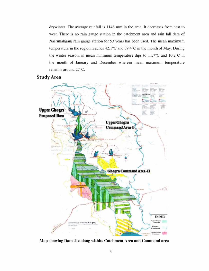
Study Area
Map showing Dam site along withits Catchment Area and Command area
4
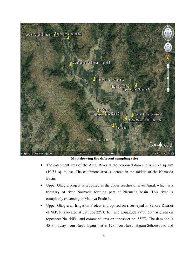
Map showing the different sampling sites
• The catchment area of the Ajnal River at the proposed dam site is 26.75 sq. km
(10.33 sq. miles). The catchment area is located in the middle of the Narmada
Basin.
• Upper Ghogra project is proposed in the upper reaches of river Ajnal, which is a
tributary of river Narmada forming part of Narmada basin. This river is
completely traversing in Madhya Pradesh.
• Upper Ghogra an Irrigation Project is proposed on river Ajnal in Sehore District
of M.P. It is located at Latitude 22o50’16’’ and Longitude 77
o03’50’’ as given on
toposheet No. 55F/1 and command area on toposheet no. 55F/2. The dam site is
45 km away from Nasrullaganj that is 17km on Nasrullahganj-Sehore road and

5
then 28km on Singur-Piplani road near Fandkipani. The nearest railway station is
Sehore. The distance of dam site from District H/Q Sehore is 75 km. At the
storage site it is proposed to construct an earthen dam across AjnalRiver, a
tributary of river Narmada.
DESCRIPTION OF THE ENVIRONMENT AND BASELINE DATA
The projects is a ‘A’ category project, however, since submergence area of this
project falls within 10 km periphery of Kheoni Wildlife Sanctuary which is at 8.75 km
from the outer limit of submergence area hence considered at the Central level.
The Catchment Area of the storage site is 26.75 sq. km. and 75% dependable
yield is 7.614 mcm. This yield can be stored upto full tank level (FTL) 378 m. Live
storage shall be 6.43 mcm. Maximum water level (MWL)shall be 379.50 m and TBL (top
bund level) shall be 381.50 m.
This would result in a submergence of 140 ha of land out of which:
Forest land =25.97 ha.
Private land =88.85 ha
Government land =25.26 ha
Area of forest that comes under submergence is approx.,18.5% of the total submergence
area.
The main land use in the area under consideration is agriculture and forest. No
village is coming under submergence; however, 69 families have been affected due to the
project who was cultivating the land to be submersed for growing:
Wheat, Maize and Soya beans besides raising livestock like cows, Buffalos,Goats, Chickens and Sheep.
Human Settlement
The majority of the population in Sehore District lives in rural area. No human
population resides in the area to be submersed after the construction of dam.
NEED OF THE DAM CONSTRUCTION
• Presently under rain-fed agriculture with very low productivity. It will also
provide drinking water to villages adjoining to submergence area.
• Most of the culturable land is rain fed and owing to erratic rainfall, very little area
is covered under sustainable agriculture. This is further compounded due to lack
of any irrigation project in the area.

6
• The irrigation requirement of the culturable area in the Ajnalsub basin can be
brought under assured irrigation only by constructing water storage projects.
• The lack of any sizeable water storage scheme in the district has hindered the
agricultural development in the area.
• In this backdrop, a minor water storage project, near Fandkipani village in
Nasrullahganj Tehsil, Sehore District, is proposed for execution.
• The beneficiary areas covered by the proposed project include Nasrullahganj
Tehsils of Sehore district.
LAND USE AND LAND COVER
The land use and land cover of the Upper Ghogra dam catchment area includes
barren/ rocky, sown, scrub/alpine scrub, forest lands, settlements/cultivation and water
body. In the entire catchment Net Sown Area (58%), and uncultivable land (7%),
cultivable waste land (2%), fallow land (1%) of thetotal catchment. Other uncultivated
land excluding both fallow land and cultivable waste land (6%).Dense forests in the
catchment constitute 26% of area.
OBJECTIVE OF THE STUDY:
1. Present study assesses environmental impact analysis of the proposed dam and
environmental management plan in the catchment and the command areas of the
AjnalRiver for clearance by the Ministry of Environment.
2. The watershed of the River has a semi-arid climate. The scarcity of water is acute.
In spite of having a rich black soil, the area is backward because of dependency
on rain fed agriculture. The increased irrigation potential due to the proposed dam
shall have a great impact on the socio-economic upliftment of the region.
3. The construction of the dam is aimed at improving the land productivity in the
command area. Proper utilization of the irrigation water from the dam is
suggested to prevent unwanted changes in the command area.
4. Monitoring the status of Ajnal River (upstream) based on physico-chemical and
biological characteristics of water and soil.
5. To explore an environmentally sound alternative to improve the status.

7
DETAILS OF THE METHODOLOGY
The data for physico-chemical parameters, aquatic organisms composition and
distribution and fisheries conditions were studied according to the "Terms of Reference
of EIA on Upper Ghogra Dam Project, Sehore" for prediction of environmental impacts
before and after dam construction on the aquatic ecosystem.
Physico-chemical characteristics
The water samples were collected between 0600hrs to 1900hrs from the selected
sites in one liter polyethylene canes. Weather, air temperature, water temperature and
dissolved oxygen were determined on the spot and the rest of the parameters were
analyzed in laboratory within time period of 48 hrs after collection. Physico-chemical
characteristics of the samples were assessed following the methodology as given in
APHA (2000).
Biological analysis
The biological population in the form of phytoplankton and zooplankton collected
from the selected stations of the Bhoj wetland were primarily identified following the
works of Desikacharya (1959), Edmondson (1959), Needham and Needham (1962),
Pennak (1978), Wanganeo and Wanganeo (1991, 2006), Battish (1992) and Sinha and
Naik (1997).
Macro-invertebrate and Fish study
For qualitative and quantitative study of macro-invertebrate fauna quadrat method
have been followed.Fishes were identified by standards keys of Jhingran(1975) and Day
(1978).
COMPONENTS OF THE EIA STUDY
Hydrology
The catchment of the Ajnal Riverat the proposed dam site is 10.33 sq miles (26.75
sq km). There is no rain gauge station in the catchment area. The rain fall data of
Ichhawar rain gauge for 33 years has been used to work out dependable rain fall and the
yield from the catchment area. The 75% dependable yield is 7.614mcum for the whole
catchment area of 10.33 sq miles.
In the project proposals for water planning following facts are considered:

8
I. As per the storage of site topograph 7.360 Mcum yield may be stored upto
R.L 378.00 m and at this R L, approximately 25.976 hact. Forest land will
come under submergence, no village will come under submergence, only
allotted revenue land and some private land will be submerged.
II. There is another dam site just D/S of this proposed site named as Ghogra
medium tank project on the same river Ajnal.
III. The catchment area of the Ghogra medium project site is 61.75 sq. km.
IV. The catchment area of Ghogra mediumproject having 75% dependable yield
of 17.576MCM as indicated in BODHI letter no. 405/Hyd/ 271-Y/12 dated
28/03/12. Out of this 17.576 MCM available yield 17.43 MCM as live storage
may be utilised in Ghogra medium project.
V. This newly proposed Upper Ghogra reservoir may be constructed as a feeder
reservoir for Ghogra medium tank project as well as its own command
between Upper Ghogra and Ghogra tank project to irrigate additional 1650
hact.of land.
VI. For dead storage purpose silt rate provision re kept as recommended by
BODHI in his letter mentioned above i.e, 0.75 acre feet/aq miles/year.
Physico-Chemical Environment
During the present study period Air temperature ranged between 24.8°C to 30.5°C.
During the study period water temperature ranged from 22.9°C-28.7°C. pH of water
varied between 8.2 to 8.7 units. Value of Total dissolved solids at selected sampling sites
varied between 170 ppm to 370 ppm. Maximum conductivity value (490 µS/cm)recorded
which indicated contribution of dissolved salts in Upper part of the Ajnal River.
Minimum conductivity (295 µS/cm) value documented in the study.Dissolved Oxygen
concentration at different sampling sites varied between 3.6 to 4.9 mg/l. During the present
investigation free CO2 only recorded (6 mg/l) and (18 mg/l). A Phenolphthalein alkalinity
range between 12 to 28 mg/l has been recorded. Total alkalinity ranges between 213 mg/l
to 389 mg/l at all the sites. At all the sampling sites Chloridevalue ranges between 19.5
mg/l to 38 mg/l. Total Hardness ranges between 136 mg/l to 260 mg/l at all the sites. The
similar trends of Calcium Hardness and Total Hardness have been observed. Calcium

9
Hardness ranges between 46 mg/l to 173 mg/l at all the sites. Ranges of Magnesium
contenthas been documented between 15 mg/l to 23 mg/l at all the sites. Concentration of
Nitrate in catchment of Upper Ajnal River ranged between 0.08 mg/l to 0. 12 mg/l.
Nitrite in catchment of Upper Ajnal River ranged between 0.02 mg/l to 0.05 mg/l.
Concentration of Orthophosphate in catchment of Upper Ajnal River ranged between
0.05 mg/l to 0. 170 mg/l. Total phosphorus in catchment of Upper Ajnal River ranged
between 0.140 mg/l to 0.290 mg/l.
While comparing water quality of present study with some worldwide accepted
water standards, water quality of feeder streams of upper Ghogra were found to be in the
desirable range as per the given standards.The physico-chemical characteristics of ground
water and surface water sample of Ghogra catchment area are under desirable limits of
drinking water. Some chemical parameters such as Dissolved Solids, Conductivity,
Dissolved Oxygen, Total Alkalinity, Nitrate and Orthophosphate recorded its higher
values in ground water sample in comparison to surface water samples which indicates
that the if seepage occurs ground water may not be change up to the harmful level.
BIOLOGICAL ENVIRONMENT
TERRESTRIAL FLORA & FAUNA:
The Sehore district supports rich dry deciduous forest (Annexure 1).The
catchment area of Upper Ghogra Dam also abounds in a wide variety of flora and fauna
which mainly consists of Teak and Bamboo species besides different types of Grasses,
Bamboos, Epiphytes and Parasitic plants.
Kheoni Wildlife Sanctuary
Kheoni Wildlife Sanctuary, established in 1955, is situated in Dewas District, Madhya
Pradesh, Spread over an area of 123 sq km.
Principal Flora:
Teak, Bija, Saja, Dhawada, Khair, Shisham, Baheda, Bamboo and others.
All are common species found in every part of central India. Not a single species is
recorded which is found in particular in catchment of Ghogra..
10
Principal Fauna:
There are number of animal species (Annexure2)were recorded in the Sehore district of
which Kheoni wildlife sanctuary forms a part. The Major animal species found in Kheoni
wildlife sanctuary include Chital, Sambar, Blue Bull, Four-Horned Antelope, Wild
Boar and Barking Deer and Wolf.
Birds
The sanctuary is also rich in birdlife. Though the number of birds (127 Species) given in
Annexure 3, includes the overall birds of the Sehore district as such, no clear-cut
demarcation has as yet been drawn regarding the birds habituating the Kheoni Wildlife
Sanctuary.
AQUATIC ECOLOGY
Phytoplankton studies
In the present study period, the overall diversity of phytoplankton (121 species)
was composed of five groups viz., Bacillariophyceae, Chlorophyceae, Cyanophyceae,
Euglenophyceae and Chrysophyceae. In the above groups, Bacillariophyceae recorded
highest number (52 species and 43 %) followed by Chlorophyceae (36 species, 30%)
which in turn was followed by Cyanophyceae 21 species (17%) and Euglenophyceae 11
species (9%). Only one species was represented from group Chrysophyceae.
Dominance of various taxonomic groups of phytoplankton on the basis of species
percentage contribution showed the following trend as:
Bacillariophyceae > Chlorophyceae > Cyanophyceae > Euglenophyceae > Chrysophyceae
Thus, theorder of dominance based on the populations of various groups was as:
Chlorophyceae > Bacillariophyceae > Cyanophyceae > Euglenophyceae > Chrysophyceae
On the basis total phytoplankton density, winter season recorded maximum
density of 3459 units 1-1
while minimum of 87 units 1-1
during post monsoon season. The
above dominant group was represented by Chlorophyceae, among this group species like
Spirogyra sp. and Zygnema sp. recorded dominance in terms of density.
On an overall seasonal basis in terms of quality, Bacillariophyceae recorded
highest group followed by Chlorophyceae in all the seasons.
During the present investigation of upper Ghogra dam, ten sites were selected at
different seasons of the study period. Site 9 (down stream) registered maximum number

11
of species (32 species) and minimum of 16 species at site 6. In this study also
Bacillariophyceae represented the dominant group at all the sites except at site S7. The
continuous dominance of diatoms in the entire stretch of the Ajnal stream indicates the
unpolluted status.
During the present investigation of phytoplankton density of upper Ghogra
streams, on site wise total density, site 8 documented highest population density of 1902
units/l while lowest of 133 units/l at site 4. Among the above highest peak,
Chlorophyceae contributed maximum (86.2%).
Cyanophyceae is the least abundant of the three main phytoplankton encountered
which indicate that the stream is not polluted. The high relative abundance of
Chlorophyceae indicates that the Ajnal stream is highly productive.However presence of
oligotrophic species indicates the unpolluted nature of the Ajnal stream.
Zooplankton Studies
In the study period, the overall diversity of zooplankton (33 species) was recorded
from four groups viz, Rotifera, Copepoda, Cladocera and Ostracoda. In the above groups,
Rotifera recorded highest number of 20 species (61 %) followed by Cladocera (8 species,
24%) which in turn was followed by Copepoda 4 species (12%) and Ostracoda 1 species
(3%).
In the present investigation period, Rotifera was dominant group at all sites in
terms of number of species.
Dominance pattern of various taxonomic groups of zooplankton on the basis of
species percentage contribution showed the following trend as:
Rotifera >Cladocera> Copepoda>Ostracoda
On quantitative basis of zooplankton, highest population density of 155 Ind.1-1
from the group Copepoda at site 7 of October month while lowest population density of 3
Ind.1-1
at most of the sites from the group Cladocera, Copepoda and Ostracoda (Table 16
andFig. 28).
Macro-invertebrate

12
Qualitative enumeration of Ghogra catchment showed 15 species of macro-
invertebrate populationbelonging to classes Insecta and Mollusca which were collected
from different selected sites.
Fishdiversity Total 21 fish species has been reported from different water resources of Sehore
district. Out of these, 9 fish species were observed the present investigation total which is
enlisted in (Table24). During sampling period few numbers of fingerlings of some fishes
were observed in different streams of Ajnal River. Not a single large size fish was
encountered from proposed Ghogra dam area.
Ambient Air Quality in Study area
A site–specific background air quality monitoring program was conducted for one
season (pre-monsoon season). Background data was collected for RSPM, SO2, NOx and
non-SPM.Four sampling stations were located in the study area to provide the
surrounding baseline airquality. Air quality was monitored with highvolume samplers, for
24 hours, twice a week. All the observed RSPM, NOx, SO2 levels were observed to be
within the prescribed standards.
Ambient Noise Quality
An assessment of baseline noise quality was undertaken to establish the status of
exposure of the major sensitive receptors.
The results of the monitoring program indicated that the daytime levels of noise
ranged between 64.3 to 70.2 dB (A)Leq.
Impact prediction and mitigation measures
Positive impacts of the proposed project:
Award for land acquisition has been passed and compensation has already been
paid. Rs. 107446875(Ten Crore Seventy Four Lakh, Forty Six Thousand, Eight Hundred
and Seventy Five) has been disbursed among 69 affected families.
Number of poor people employed by surrounding commercial farmers will get benefitted
by the dam construction in various ways.
Impact of dam on productive land:However, loss of agricultural land due to
impoundment will be there though relatively small compared to the available arable land.

13
On wildlife habitat: Wildlife is in fact expected to resurface in the area due to improved
water supply.
On social and cultural infrastructure: No social or cultural infrastructure is located
within the area as such no impact will be there on this aspect.
Increased employment opportunities: Construction and operation of dams create
opportunities for jobs mainly for the local communities.
Increase in local population: The construction of the dam will have an influence on the
population size of the area.
Increase in local economic activities: The irrigation scheme will provide both
permanent and temporal employment to the local people. This means more income for
the community in the area resulting into increased economic activities.
Increased fish production: Though fish mortality may be high initially, fish production
is expected to increase significantly with time in the dam.To enhance this, the developer
will: i) encourage natural fish restocking of the dam and stream,
ii) promote use of sustainable methods of fishing
Boost to economic growth: The operation of dam has made it possible for local
community to have additional reliable water supply throughout the year, effectively
enabling to increase its production levels.
Increase in groundwater level: Impoundment of a river may lead to increased
percolation of water to deeper levels resulting in localized increase in groundwater level
and consequently overall quantity.
Increased irrigated area: The presence of dam has made it possible for locals to
increase its land under irrigation.
Increased crop production: The additional water storage from dam has made it possible
for local people to increase its crop production.
Stepwell (Bawdi):Though the “Stepwell”is present above the submergence area it will
also be benefitted on account of its possible recharge from the dam. Presently it is being
used for both portable and for irrigation purpose.
14
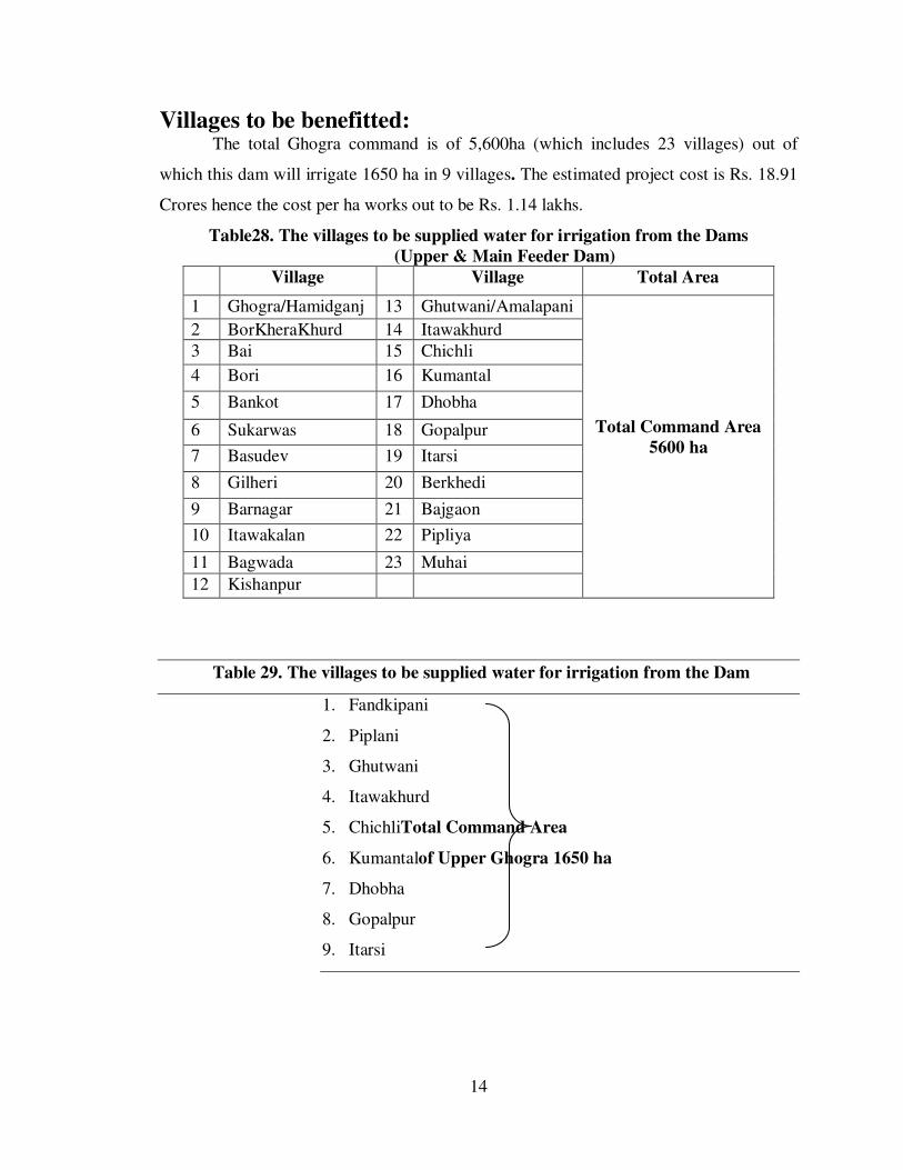
Villages to be benefitted: The total Ghogra command is of 5,600ha (which includes 23 villages) out of
which this dam will irrigate 1650 ha in 9 villages. The estimated project cost is Rs. 18.91
Crores hence the cost per ha works out to be Rs. 1.14 lakhs.
Table28. The villages to be supplied water for irrigation from the Dams
(Upper & Main Feeder Dam)
Village Village Total Area
1 Ghogra/Hamidganj 13 Ghutwani/Amalapani
Total Command Area
5600 ha
2 BorKheraKhurd 14 Itawakhurd
3 Bai 15 Chichli
4 Bori 16 Kumantal
5 Bankot 17 Dhobha
6 Sukarwas 18 Gopalpur
7 Basudev 19 Itarsi
8 Gilheri 20 Berkhedi
9 Barnagar 21 Bajgaon
10 Itawakalan 22 Pipliya
11 Bagwada 23 Muhai
12 Kishanpur
Table 29. The villages to be supplied water for irrigation from the Dam
1. Fandkipani
2. Piplani
3. Ghutwani
4. Itawakhurd
5. ChichliTotal Command Area
6. Kumantalof Upper Ghogra 1650 ha
7. Dhobha
8. Gopalpur
9. Itarsi

15
Negative impacts of the proposed project:
There is every possibility that the wild species, benefitted by the availability of
water in the Kheoni Wildlife Sanctuaryterritory will possibly descend along with the
receding water level up to its dead storage level.
Displacement of people and land: The number of people actually living in the
downstream area of the proposed dam. Through field surveys it was established that the
project area particularly impoundment areas are part of commercial fields meant for
agricultural activities. Total of 140.10 ha of land will get submerged (private land -88.859
ha, forest land – 25.976 ha and Revenue land – 25.265 ha) As such no households are
expected to be relocated due to inundation.
On the top soil and dam sedimentation: The nature of the project demands use of
heavy machinery during construction mainly for earth movement and leveling. This may
lead to instability of the soil in the area and as a result cause soil erosion mainly of top
soil.
Dust pollution: Dust pollution is expected to pose a negative impact that can affect
human health.
Pollution due to increased usage of pesticides and fertilizers: Increased availability of
water supply throughout the year for irrigation may lead to higher usage of agro
chemicals.
Encroachment of aquatic weeds and water quality of the dam: The aquatic ecosystem
in newly constructed dam is very unstable and water is often eutrophic as a result of the
inundation of fertile land.
Nine villages that will be benefitted directly by the Upper Ghogra Dam are as:
Land type Area lost Area benefited
1 Agricultural
land
88.859 ha The total Ghogra command is of 7,000 ha out of
which this dam willIrrigate 1650 ha in 9 villages
(Fandkipani, Piplani, Ghutwani, Itawakhurd, Chichli,
Kumantal, Doban, Gopalpur, and Itarasi).
This is about 8.5% of total proposed CCA of 1650
Ha. Revenue land under submergence has been
transferred to the Water Resources Department.
2 Forest land 25.976 ha
3 Revenue land 25.265 ha
Total land 140.10 ha

16
Recommendations:
Fish is important to our society not only as a living being but also as a basic food for
thousands of years and fishing is a sport or recreational activity for a lot of people
(Horvath et. al., 1998). Human population growth and increased water usage are
placing greater demands on the world's freshwater supplies (Postel, 2000).
Consequently, alterations in the hydrologic regime due to structural and operational
measures such as dam construction and associated water diversion, exploitation of
groundwater aquifers, stream channelization and inter-catchment water transfer are
producing global-scale effects on the environment (Rosenberg et al., 2000).
The storage capacity allows dams to generate electricity, to supply water for agriculture,
industries and municipalities, to mitigate flooding and to assist river navigation
(Rosenberg et al., 2000). Large dams and river diversions have proven to be primary
destroyers of aquatic habitat, contributing substantially to fisheries destruction, the
extinction of species and the overall loss of ecosystem services on which human
economy depends (Postel, 1998).
Despite the benefits that dams provide, they can have significant environmental costs.
The size and function of the dam will influence the impacts the dam has on the
environment.
Typically, the larger the dam the greater the potential for environmental impacts.
However, small dams built in highly sensitive ecosystems may have significant
impacts. A number of small dams built on the same waterway will also have similar
effects as large dams on total stream flow. How the proponent operates the dam will
also effect how much of a risk the dam poses to water resources. Catchment land use
practices have a strong influence on the quality of surface water sources.
A dam water balance should be determined that includes dam water inputs from rainfall
and run-off, and outputs from evaporation, seepage and draw.
If the dam will block the migration of any aquatic fauna, then the design should include
additional infrastructure to facilitate this movement such as fish ladders.
To reduce the potential damage caused by clearing, only the minimum amount of
vegetation necessary should be cleared. This should match the footprint of the dam

17
when full. The benefits that vegetation surrounding a dam can provide should be
considered.
During construction, bypass channels should be used to divert flow around the
construction site to prevent sediment being transported downstream.
Dams should be built during the dry season to allow construction to a sufficiently high
standard without the dam beginning to fill with water.
Some seepage from the dam will inevitably occur. A rate of 10-9
metres per second (water
flow rate) is an acceptable level of seepage. The use of compaction, material
amelioration or additives such as concrete or bentonite, geotextiles and fabrics
(artificial liners) can reduce water loss through seepage.
Environmental water provisions (EWPs) are an important component in determining if a
dam is likely to threaten the ecological values of a catchment. EWPs are the water
regimes that are provided in the water allocation process taking into account
ecological, social and economic.
Impacts. Water in excess of the EWPs may be available for consumptive uses and defines
the sustainable yield of water from the waterway. If there is concern that a dam will
diminish this yield and threaten the sustainability of downstream ecosystems, then a
water resource investigation (WRI) may be required by the Department of Water.
Water quality testing should be carried out to determine if water contains toxins or
pathogens. If significant contamination is found then remedial action should be taken
to control the source.
Good management practices play an important part in controlling fluctuations in water
quality. Regular maintenance and monitoring of the dam is recommended. Regular
testing and analysis of the water will provide warning if changes are occurring and
allow action to be taken prior to a problem developing.
CATCHMENT AREA TREATMENT
• Catchment of 26.75 sq km is partly barren and partly cultivated, vulnerable to
erosion and weathering
• The present rate of siltation in catchment is 0.75 MAF/year/sq km
• 90% of the cultivation in catchment area is under rain-fed agriculture

18
• Suitable measures will be taken up to decrease the rate of siltation like
construction of dykes, gully traps, farm bunding, check dams, slope stabilization,
stone pitching, agronomical practices, crop rotation, and so on and so forth.
• Through these measures, it is expected to bring down the rate of siltation by 50%.
COMMAND AREA DEVELOPMENT
• CADWM project will be prepared & accordingly ofd activities will be
implemented
• Proper drainage will be provided to mitigate waterlogging and salinity
• Sustainable farming will be promoted
• Organic farming will be promoted
• Crop rotation will be followed
• Horticulture and farm forestry will be encouraged especially of citrus fruits,
suitable to the agro-climatic conditions of the district
• Thrust will be placed on social forestry