
Transboundary Water Cooperation in the Orange Senqu River Basin

SENQU AND SENQUNYANE RIVER BRIDGES AND CONNECTING ROAD
ENVIRONMENTAL IMPACT ASSESSMENT REPORT
July 6 2006
PREPARED FOR Government of the Kingdom of Lesotho:
Ministry of Public Works and Transport
PREPARED BY Africon
Environment and Sustainability Consulting
© 2006, Africon Environment and Sustainability. All rights reserved.
E1424v 2
Pub
lic D
iscl
osur
e A
utho
rized
Pub
lic D
iscl
osur
e A
utho
rized
Pub
lic D
iscl
osur
e A
utho
rized
Pub
lic D
iscl
osur
e A
utho
rized
Pub
lic D
iscl
osur
e A
utho
rized
Pub
lic D
iscl
osur
e A
utho
rized
Pub
lic D
iscl
osur
e A
utho
rized
Pub
lic D
iscl
osur
e A
utho
rized

Senqu and Senqunyane Bridges Environmental Impact Assessment
ENVIRONMENTAL IMPACT ASSESSMENT FOR THE PROPOSED CONSTRUCTION OF THE SENQU AND SENQUNYANE RIVERS BRIDGES AND CONNECTING ROAD REPORT NO: 101810 /EIA PREPARED BY: Africon Environment and Sustainability Christie House Orpen Road MASERU 100 CONTACT: Mr. Tsebang Putsoane Tel: + 266 2231 5788 Fax: + 266 2231 0490 E-MAIL: [email protected] PREPARED FOR: Government of the Kingdom of Lesotho: Ministry of Public Works and Transport PO Box 20 MASERU 100
EIA Lesotho ITP 6 July 2006.doc i

Senqu and Senqunyane Bridges Environmental Impact Assessment
I EXECUTIVE SUMMARY
The Lesotho Government aims to achieve economic growth, reduce poverty and improve service delivery through the implementation of the Transport Sector Programme. This programme, funded through local and international sources, will focus on significant improvements within the transport infrastructure sector by the year 2010. A component of the TSP is the construction of a new road between Semonkong and Ha Ramoholi near Ha Sekake. In 1999, Muir Associates were appointed to undertake a feasibility study for a new bridge over senqu river as well as a road linking Seforong and Semonkong. This study selected the road corridor as well as the bridge crossings across Senqunyane and Senqu rivers. In 2000 WSP were appointed to undertake a detailed engineering design of the road between Semonkong and Sekake. Consult 4 were appointed by the Ministry of Public Works and Transport to conduct the Environmental Impact Assessment and Social Impact Assessment for the roads project. The design and construction of bridges crossing the Senqu and Senqunyane Rivers at Pitsaneng and Mokopung respectively were excluded from the Consult 4 Scope of Works. Africon has been appointed to conduct the redesign and EIA/SIA for the bridges, the approach roads and road connecting the two bridges from Mokopung to Pitsaneng, as well as the maintenance of an existing gravel access road from Senqu bridge site through Seforong to Ha Mosi during construction. The EIA/SIA is required in terms of Section 27 of the Environment Act, as well as items which may require addressing in the EIA. The project has been identified in terms of the World Bank Operational Policy 4.01 as a Category B project, but requires that the Ministry of Public Works and Transport submit an EIA. The study area is located approximately 100 km south-east of Maseru, and is situated at the confluence of the Senqu and Senqunyane Rivers. The proposed Senqu Bridge is situated approximately 8 km upstream of the confluence of the two rivers, between the Pitsaneng and Seforong settlements. The proposed Senqunyane Bridge is located approximately 2 km upstream of the confluence between Mokopung and Hloahloeng. A connecting road will be constructed between the bridges, passing through Hloahloeng and Pitsaneng. The detailed design of the road and bridge structures has been completed. The study area occurs within a summer rainfall area, with approximately 80% of the annual rainfall occurring as thunderstorms between October and March. Temperatures are mild, with rapid temperature drops to -10°C occurring in winter. The geology comprises Basalts of the Drakensberg Formation of the Karoo Supergroup with the eastern portions underlain by Arenite and Siltstones of the Clarens Formation. Doleritic intrusions, often associated with the Karoo Supergroup, occur throughout the study
EIA Lesotho ITP 6 July 2006.doc i

Senqu and Senqunyane Bridges Environmental Impact Assessment
area. Soil distribution patterns are relative to the underlying parental material and differs only texture and depth. The sandy nature of the soils, coupled with topography and low vegetation cover is conducive to the formation of erosion gullies and rills. Topography of the study area is dominated by an elevated dissected plateau at approximately 2 000 mamsl. Hydrology of the area is highly dendritic, with drainage in a south-westerly direction. The peculiar, meandering characters of all major river systems is related to a combination of upliftment of the previous plateau surface, erosion by rivers and discontinuities in the bedrock. The biophysical environment associated with the study area comprises grassland with scattered sclerophyllous shrubs. The woody component is predominantly associated with river banks and sheltered gorges. Natural vegetation is predominantly associated with steeper areas, and is utilised as communal grazing land. Flatter areas are effectively cleared for cultivation. Floral biodiversity is thus low. Faunal diversity is generally limited in Lesotho, and restricted to small mammals, reptiles and avifauna. Loss of habitat and hunting contribute to this low biodiversity. The average household size is approximately 6.5, ranging from 4 to 8 individuals in a household. Male to female ratios are approximately 1:1, although this becomes more skewed towards females in older age groupings and reflects the effects of HIV/AIDS on the population. Unemployment is high, with approximately half (49%) of the economically active population between 20 and 65 unemployed. Education levels in rural areas are usually low, with more than 72 % not having primary education only. Less than 1% of the population in the study area have tertiary/higher educations. The majority of households interviewed indicated an average monthly income below M 500. Income in rural communities is predominantly linked to farming, although formal employment and pensions are required to augment income. Public Participation was conducted by Consult 4 in 2005, with follow-up consultations conducted in December 2005/January 2006 following the proposal to alter the alignments and in May 2006 when the alignment had been finalised. The SIA and RAP were completed as follows:- 1) A site screen was conducted in March 2005 by Consult 4, during which access to
communities was assessed. It was determined that access is highly limited, and requires the use of horses, four wheel drive vehicles and hiking to access remote communities.
2) A questionnaire survey was conducted, utilising ten fieldworkers trained to administer the survey. Local Chiefs/Headmen were approached to facilitate community interaction and participation. A desktop assessment was conducted to identify potentially impacted areas, followed up with field assessment. Interviews were conducted with affected land owners through the local Chiefs.
EIA Lesotho ITP 6 July 2006.doc ii

Senqu and Senqunyane Bridges Environmental Impact Assessment
3) Community consultations were then held, at which preliminary findings were presented and verified, and comments and queries sought.
The consultations held in December 2005/January 2006 were principally held to identify affected landowners along the new proposed alignments. Detailed layout and design was completed in May 2006, following which additional consultations were held. These consultations consisted of:- 1) Meetings with local Chiefs to confirm the alignment, and present the alignment to
the community. 2) Survey affected properties along the alignment, identification of landowners of
properties affected with the local Chiefs or their representatives, and consultations with property owners in order to compile an asset register.
3) Additional community meetings (Pitsos) held In Hloahloeng and Seforong. Based on the process conducted, it was found that the majority (97%) of the population supported the project and felt that it was necessary to support economic development in the area. The consensus was that the project would improve access to education, health and business facilities, as well as opening business opportunities in previously inaccessible areas. It was generally felt, however, that the proposed roads would lead to increased crime in the area as well as transmission of STI’s. Previous studies identified and evaluated various alternatives in terms of the project. Minor realignment of the connecting road has been proposed to facilitate access to the clinic at Hloahloeng. An alternatives assessment was conducted to determine the broad (Macro) social and environmental impacts of the proposed road alternatives. Based on the outcome of this assessment, a preferred alternative was identified and a detailed EIA (micro impact) was conducted. One of the objectives of this study is to identify and quantify the potential positive and negative impacts which the proposed roads will have on the receiving biophysical and socio-economic environment. These impacts have been generated and identified by field investigation, specialist studies and evaluation. Input from the public and various authorities consulted during this process are also incorporated. The negative impacts will be mitigated to minimise their significance and the positive impacts will be enhanced as far as possible. Significance of the impact has been determined as a function of the probability, duration, extent and intensity. A summary of the potential impacts is provided below:-
ENVIRONMENTAL ASPECT
POTENTIAL IMPACT
MITIGATION
Surface and groundwater quality
Pollution of natural resources
• Storage of hazardous material in sealable containers
• Bunded fuel storage areas • Removal of domestic, construction or
EIA Lesotho ITP 6 July 2006.doc iii

Senqu and Senqunyane Bridges Environmental Impact Assessment
ENVIRONMENTAL ASPECT
POTENTIAL MITIGATION IMPACT
effluent waste materials to registered facilities
Social structure Impact on social structure • Siting of camp to be negotiated with communities
• Health, HIV/AIDS awareness training provided to imported labourers
• Labour to be drawn from local communities as far as possible
Land use Loss of grazing • Compensation to be provided for loss of land tenure
Vegetation Loss of biodiversity • Vegetation removal only within alignment • Where possible, plant rescue to occur along
alignment Air quality
Increased emissions and dust generation
• Dust suppression to be conducted • Vegetation cover to be maintained as far as
possible • Vehicle emission controls to be
installed/maintained Noise levels Increased noise generation • Vehicles to be well maintained and fitted with
correct muffler systems • Normal working hours to be followed (06:00 to
18:00) Soil erosion Increased susceptibility to
erosion • Erosion control (temporary or permanent) to be
installed prior to vegetation stripping Socio-economic Loss of income
Job creation Increased STI’s due to influx of migrant workers
• Compensation to be provided for loss of land tenure
• Local labour to be utilised • HIV/AIDS and general health awareness training
to be provided • Environmental awareness training to be
provided Aquatic/bank vegetation
Loss of biodiversity • Vegetation to be cleared in alignment only • If possible, plant rescue to be conducted along
alignment Surface water flow Alteration of surface water
flow patterns • Placement of pillars to occur during low flow
period (if possible) • Surface area of pillars to be minimised • Pillar shape to facilitate flow around pillar and
prevent build-up of material Water quality Increased sedimentation due
to erosion • Pillar shape to facilitate flow around pillar and
prevent build up of material
Based on the findings of the macro and micro EIA, the preferred road alternative and bridge project is expected to impact negatively on hydrological function, dust emissions and ambient noise levels and biodiversity during the construction phase. While infrastructure development can be expected to have a positive impact on job creation and improving access to health, education and business facilities, the influx of migrant workers during construction may increase transmission of HIV/AID’s or other STI’s within local communities. Finally, the construction of the road will result in sterilisation of land currently under cultivation which will require compensation, as well as potentially impact on residences or structures in close proximity to the alignment. Note
EIA Lesotho ITP 6 July 2006.doc iv

Senqu and Senqunyane Bridges Environmental Impact Assessment
that no relocation of residences should be required, although strict management will be required during the construction phase.
The following recommendations were therefore made:-
• Public consultation must be ongoing through the various phases of the project
to ensure that the compensation process is acceptable to all stakeholders as well as ensuring community support for the project;
• Ensure establishment of a steering committee to address community concerns and/ or grievances;
• Suitable compensation must be provided in accordance with strategies identified in the Resettlement and Compensation Policy Framework and Resettlement Action Plan;
• The findings of the EIA must be considered and EMP implemented; • Due care and responsibility be applied as detailed in the EIA and EMP • The mitigation of negative impacts as described in the impact evaluation
tables and as elaborated by the EMP be implemented; • An Environmental Site Agent (ESA) must be appointed to oversee the
implementation of the EMP on site during the construction phase. • Local labour must be used as far as possible during the construction phase as
far as possible; • Labourers must be educated and trained to provide much needed skills which
they can utilise on other projects; • The EMP to be revised on an ongoing basis during the construction phase to
ensure compliance with acceptable standards and objectives; • Erosion control measures must be implemented throughout the project area
where required and phased rehabilitation instituted during construction; • Effective storm water management systems and structures must be put in
place to ensure hydrological functioning. • Labourers must be educated in terms of health issues, and in particular
HIV/AID’s/STD’s; • Traffic calming measures should be introduced along the alignments to reduce
traffic speeds and associated risk to local roads users such as pedestrians or livestock; and
• Strict control must be instituted at the construction camp, to monitor and mitigate all potential impacts associated with such camps.
EIA Lesotho ITP 6 July 2006.doc v

Senqu and Senqunyane Bridges Environmental Impact Assessment
TABLE OF CONTENTS
I EXECUTIVE SUMMARY ..............................ERROR! BOOKMARK NOT DEFINED.
II ABBREVIATIONS.....................................ERROR! BOOKMARK NOT DEFINED.
III TERMS AND DEFINITIONS .....................ERROR! BOOKMARK NOT DEFINED.
1 INTRODUCTION.......................................ERROR! BOOKMARK NOT DEFINED.
1.1 Project Background..............................................Error! Bookmark not defined. 1.2 Project Description...............................................Error! Bookmark not defined.
1.2.1 Regional Setting ..........................................Error! Bookmark not defined. 1.2.2 Detailed Site Layout ....................................Error! Bookmark not defined.
1.3 Project Brief ..........................................................Error! Bookmark not defined. 1.4 Statutory and Institutional Procedure Requirements .....Error! Bookmark not defined.
1.4.1 Environment Act, 2001 ................................Error! Bookmark not defined. 1.4.2 World Bank OP 4.01 and 4.12.....................Error! Bookmark not defined.
1.5 Project Objectives ................................................Error! Bookmark not defined. 1.6 Structure of the Report ........................................Error! Bookmark not defined.
2 BASELINE ENVIRONMENTAL DESCRIPTION ...................................................8
2.1 Physical Environment ......................................................................................8 2.1.1 Climate ........................................................................................................8 2.1.2 Geomorphology and soil..............................................................................8 2.1.3 Hydrology ..................................................................................................10 2.1.4 Topography ...............................................................................................10
2.2 Biophysical Environment...............................................................................11 2.3 Environmental Sensitivity..............................................................................14 2.4 Social-Economic Environment......................................................................14
2.4.1 Land Use ...................................................................................................15 2.4.2 Sites of Cultural or Archaeological interest................................................15 2.4.3 Socio-Economic Activity ............................................................................16
3 PUBLIC PARTICIPATION ...................................................................................18
3.1 Public participation to date............................................................................19 3.1.1 Site screen.................................................................................................19 3.1.2 Socio-Economic Survey ............................................................................19 3.1.3 Community Consultations..........................................................................21
3.2 Outcomes of the Public Participation Process............................................21 3.3 Subsequent Participation Process to be conducted...................................21
4 ALTERNATIVES TO THE PROJECT..................................................................27
4.1 Alternative to the Location of the Bridges ...................................................27 4.2 Alternatives to the Bridge Design and layout ..............................................27
EIA Lesotho ITP 6 July 2006.doc i

Senqu and Senqunyane Bridges Environmental Impact Assessment
4.3 Alternatives to connecting road alignment..................................................27
5 EIA METHODOLOGY AND APPROACH ...........................................................30
5.1 Introduction.....................................................................................................30 5.2 Evaluation Methods........................................................................................30
6 IMPACT DESCRIPTION ......................................................................................33
6.1 Introduction.....................................................................................................33 6.2 Macro Impacts Associated with the Construction Phase...........................33
6.2.1 Air Quality ..................................................................................................33 6.2.2 Construction Camp....................................................................................34 6.2.3 Disturbance of Hydrological Patterns ........................................................35 6.2.4 Flora and Fauna ........................................................................................36 6.2.5 Erosion along Alignment / River Crossings ...............................................36 6.2.6 Noise Pollution...........................................................................................37 6.2.7 Damage to Existing Infrastructure .............................................................38 6.2.8 Socio-Cultural Environment.......................................................................38
6.3 Macro Impacts Associated with the Operational Phase .............................41 6.3.1 Air Quality ..................................................................................................41 6.3.2 Noise Pollution...........................................................................................41 6.3.3 Disturbance of Surface Flow .....................................................................42 6.3.4 Socio-Cultural Environment.......................................................................43
6.4 Summary of Impacts ......................................................................................46 6.5 Environmental Impact Checklists .................................................................47
7 ENVIRONMENTAL MANAGEMENT PLAN ........................................................54
7.1 Institutional Matters........................................................................................54 7.1.1 Steering Committee...................................................................................54 7.1.2 Environmental Site agent ..........................................................................56 7.1.3 Environmental and HIV/AIDS Awareness Training for Site Personnel ......57 7.1.4 Communication Procedures on Site ..........................................................57 7.1.5 Record Keeping.........................................................................................59
7.2 Monitoring and Evaluation of the EMP implementation .............................59 7.2.1 Environmental Monitoring..........................................................................59
7.3 Environmental Mitigation and Management ................................................62
8 CONCLUSIONS...................................................................................................64
9 RECOMMENDATIONS.............................ERROR! BOOKMARK NOT DEFINED.
10 REFERENCES.....................................................................................................68
APPENDIX A: TERMS OF REFERENCE TO AFRICON BY THE CLIENT..............70
APPENDIX B: VEGETATION SURVEY CONDUCTED BY LERATO KOSE AND MOLETSI POLAKI IN JANUARY 2006........................................................................71
EIA Lesotho ITP 6 July 2006.doc ii

Senqu and Senqunyane Bridges Environmental Impact Assessment
APPENDIX C: MINUTES OF PUBLIC MEETINGS AT SEFORONG AND HA NKAU 72
APPENDIX D: RESETTLEMENT ACTION PLAN ....................................................73
APPENDIX E: DETAILED ENVIRONMENTAL MANAGEMENT PLAN...................74
APPENDIX F: EXAMPLE OF A METHOD STATEMENT.........................................14
EIA Lesotho ITP 6 July 2006.doc iii

Senqu and Senqunyane Bridges Environmental Impact Assessment
LIST OF TABLES, FIGURES AND PHOTOGRAPHS
TABLE 3-1: LIST OF PROPERTIES AFFECTED BY THE PREFERRED ALIGNMENT ...........................23 TABLE 4-1: MACRO IMPACTS ASSOCIATED WITH THE PROPOSED ALTERNATIVES ON SELECTED
ENVIRONMENTAL PARAMETERS..........................................................................................28 TABLE 6-1: SUMMARY OF IMPACTS.........................................................................................46 TABLE 6-2: MICRO IMPACT TABLES - SENQU AND SENQUNYANE BRIDGES AND CONNECTING
ROAD ...............................................................................................................................48 TABLE 7-1: SUMMARY OF IMPACTS.........................................................................................62
FIGURE 1-1: LOCALITY OF THE STUDY AREA, INDICATING PROPOSED LAYOUT OF BRIDGES AND
CONNECTING ROAD ..........................................................ERROR! BOOKMARK NOT DEFINED. FIGURE 2-1: CLIMATIC DATA .....................................................................................................8 FIGURE 6-1: MICRO IMPACT ASSESSMENT –ENVIRONMENTAL FEATURES ..................................50 FIGURE 6-2: MICRO IMPACT ASSESSMENT –ENVIRONMENTAL FEATURES ..................................51 FIGURE 6-3: MICRO IMPACT ASSESSMENT –ENVIRONMENTAL FEATURES ..................................52 FIGURE 6-4: MICRO IMPACT ASSESSMENT –ENVIRONMENTAL FEATURES ..................................53 FIGURE 7-1: ESTABLISHMENT OF STEERING COMMITTEE AND IMPLEMENTATION OF
COMPENSATION PROGRAMME ...........................................................................................55 FIGURE 7-2: MONITORING AND EVALUATION OF THE EFFECTIVENESS OF THE EMP ..................62
PLATE 1: DOLERITIC DYKE UPSTREAM OF SENQU RIVER CROSSING SITE ......................................9 PLATE 2: DEEPLY INCISED RIVER CHANNELS.............................................................................10 PLATE 3: DEEPLY INCISED RIVER CHANNELS.............................................................................11 PLATE 4: COMMELLINA AFRICANA SUBSP. KREBSIANA (QENA)....................................................12 PLATE 5: ALOE BROOMII ...........................................................................................................13 PLATE 6: ALOE PRATENSIS (LEKHALA-QHALANE).......................................................................13 PLATE 7: DICOMA ANOMALA (HLOENYA)....................................................................................13 PLATE 8: DICOMA MACROCEPHALA ...........................................................................................13 PLATE 9: LEPUS SAXATILIS (‘MUTLANYANA, SCRUB HARE).........................................................13 PLATE 10: EXTENSIVE CULTIVATION WITHIN STUDY AREA, HA NKAU (ALONG PROPOSED
ALIGNMENT)......................................................................................................................15 PLATE 11: CATTLE HUSBANDRY, HA NKAU ................................................................................15 PLATE 12: COMMUNAL GRAVEYARD LOCATED ADJACENT TO PROPOSED ACCESS ROAD
(PITSANENG) ....................................................................................................................16 PLATE 13: COMMUNAL GRAVEYARD LOCATED ADJACENT TO PROPOSED ACCESS ROAD
(SEFORONG) ....................................................................................................................16
EIA Lesotho ITP 6 July 2006.doc iv

Senqu and Senqunyane Bridges Environmental Impact Assessment
II ABBREVIATIONS
BPEO Best Practicable Environmental Option
EIA Environmental Impact Assessment
EMP Environmental Management Plan
ESMU Environmental and Social Monitoring Unit (MoPWT)
GoL Government of Lesotho
I&AP’s Interested and Affected Parties
IEM Integrated Environmental Management
MoPWT Ministry of Public Works and Transport
NES National Environmental Secretariat
OP 4.01 World Bank Operational Policy 4.01 on Environmental Assessment
OP 4.12 World Bank Operational Policy 4.12 on Involuntary Resettlement
PPP Public Participation Process
RAP Resettlement Action Plan
RB Roads Branch (MoPWT)
RD Resettlement Desk (MoPWT)
RoD Record of Decision
TSP Transport Sector Programme
EIA Lesotho ITP 6 July 2006.doc v

Senqu and Senqunyane Bridges Environmental Impact Assessment
III TERMS AND DEFINITIONS
Audit - regular inspection and verification of construction activities for implementation of the EMP Batch plant - a concrete or plaster mixing facility and associated equipment and materials. Best Practicable Environmental Option: BPEO is the outcome of a systematic consultative and decision-making procedure that emphasizes the protection of the environment across land, air and water. It establishes, for a given set of objectives, the option that provides the most benefit or least damage to the environment as a whole at an acceptable cost in the long term and as well as the short term. Bund - enclosure under / around a storage facility to contain any spillage. Contractor - the principal persons / company undertaking the construction of the development Developer - The developer is the same person as the applicant or the client, the Ministry of Public Works and Transport (MOPWT) Development site - boundary and extent of development works and infrastructure. Emergency situation – An incident, which potentially has the ability to significantly impact on the environment, and which, could cause irreparable damage to sensitive environmental features. Typical situations entails amongst others the:-
• Spill of petroleum products and lubricants into the aquatic system; • Potential damage, erosion and slumping of the unstable river embankment; • Potential event of impeding the continuous flow of water to downstream
water users dependant on the flow; and • Dangerous situation where livestock and small children can be injured by
any activity emanating from the construction or rehabilitation of the project implementation.
Engineer - A person who represents the client and is responsible for enforcing the technical and contractual requirements of the project.
EIA Lesotho ITP 6 July 2006.doc vi

Senqu and Senqunyane Bridges Environmental Impact Assessment
Environment: Associated cultural, social, soil, biotic, atmospheric, surface and groundwater aspects impacted on (or which could potentially be impacted on) by the proposed road projects. Environmental Impact Assessment: A process of assessing the potential impact of a proposed activity on the environment and the surrounding community. The process involves the assessment of both biophysical and social impacts to propose mitigation and make final recommendations. Environmental Management Plan: A document that contains recommendations for the control or management of the potential significant impacts of operations on the environment and recommendations to contain or mitigate actual impacts. ESA - Environmental Site Agent: - Person responsible to Developer tasked with implementing and controlling the environmental requirements during construction. Feasible: Acceptable, capable of being used or implemented successfully, without unacceptably damaging the environment. Interested and/or Affected Parties: Any member of the public, non-government organisation or local community with an interest in the project, or which may be impacted on by the proposed project. Public Participation Process: A process of facilitating the participation of the general public in the EIA process. The process includes publishing of notices, public meetings and local community involvement in order to inform the public regarding projects which may impact on them or their environment, to identify problems and to receive input from interested and affected parties regarding projects and activities. RE – Resident Engineer: - Represents the Engineer on site. Risk: The scientific judgement of probability of harm. Significant: Factors or considerations are termed significant when they are important, because they are of consequence. For example, they will have a detectable influence on a process, the environment, or the end result.
EIA Lesotho ITP 6 July 2006.doc vii

Senqu and Senqunyane Bridges Environmental Impact Assessment
1 INTRODUCTION
1.1 Project Background
The Government of Lesotho (GoL) aims to achieve economic growth, reduce poverty and improve service delivery through the implementation of the Transport Sector Programme (TSP). This programme, funded through local and international sources, is planned to focus on significant improvements within the transport infrastructure sector by the year 2010. A component of the TSP is the construction of a new road between Semonkong and Ha Ramoholi near Ha Sekake. Consult 4 were appointed by the Ministry of Public Works and Transport (MOPWT) to conduct the Environmental Impact Assessment (EIA) and Social Impact Assessment (SIA) for the roads project. However,a subcomponent of this road comprising the two bridges crossing the Senqu and Senqunyane Rivers at Pitsaneng and Mokopung respectively did not form part of the Scope of Works of Consult 4. Muir Associates had been appointed in 1999 to conduct a feasibility study for the construction of these bridges, with WSP International subsequently appointed in 2000 to conduct a feasibility review as well as preliminary and final design of these bridges. Based on the findings of these studies, Africon has been appointed to conduct a design review of the bridges, as well as the EIA/SIA for the bridges. The design review concluded that the bridge over the Senqu River should be relocated to a point approximately 1.2 km upstream, thereby necessitating a realignment of the interconnecting road between the two bridges (Alignment A). Upon review, a variant of this alignment was introduced to reduce the area of arable land affected (Alignment B). A subsequent further deviation to Alignment B was proposed by the World Bank to improve access to the Clinic at Hloahloeng (Alignment C). Alignment C follows existing tracks for the most part. The scope of Senqu and Senqunyane civil works funded under the ITP comprises construction of the two bridges; the approaches and interconnecting road to bitumen standard (10 km) as well as the maintenance of the existing gravel road (7 km) from between Senqu bridge site and Ha Mosi. This EIA covers the scope defined above.
1.2 Project Description
1.2.1 Regional Setting
The study area is located approximately 100 km south-east of Maseru, and is situated at the confluence of the Senqu and Senqunyane Rivers (Figure 1.1). The three proposed alignments investigated are indicated.
EIA Lesotho ITP 6 July 2006.doc 1
Senqu and Senqunyane Bridges Environmental Impact Assessment
EIA Lesotho ITP 6 July 2006.doc 2

Senqu and Senqunyane Bridges Environmental Impact Assessment
EIA Lesotho ITP 6 July 2006.doc 3

Senqu and Senqunyane Bridges Environmental Impact Assessment
The proposed Senqu Bridge is situated approximately 8 km upstream of the confluence of the two rivers, between the Pitsaneng and Seforong settlements. The proposed Senqunyane Bridge is located approximately 2 km upstream of the confluence between Mokopung and Hloahloeng. A connecting road will be constructed between the bridges, passing through Hloahloeng and Pitsaneng, extending for about 3 km across Senqu where it will connect to the proposed Semonkong – Ha Ramoholi road. Note that the existing road between Senqu bridge site and Ha Mosi, passing through Seforong, will be maintained to provide access during the construction phase.
1.2.2 Detailed Site Layout
The proposed Layout of the bridges and connecting roads is indicated in Figure 1-1. Note that, while a 30 m Right of Way (RoW) has been proposed, the detailed design and layout requires that this RoW be relaxed through villages at Mokopung, Pitsaneng and Lehonyeling to avoid demolition of existing structures that are not in the roadway. The 7 km alignment between Mokupung and Lehonyeling near Pitsaneng will be coincident with the existing track over rocky terrain. This track is currently used by pick-ups servicing the clinic, airfield and population on the peninsular. Alignments A, B and C are variants of this proposed road which are a few meters apart in the same corridor affecting the same properties to varying degrees. Alignment C affects slightly less arable land than Alignment A and Alignment B (although about 100 meters longer than alignment B), at the same time running closer to the Clinic at Hloahloeng than the other proposed alignments. An existing gravel road between the Senqu Bridge crossing and Seforong, approximately 8 km long, will be maintained and utilised as an access road during the construction phase (Figure 1-1). Geometric and Pavement design of the roads was conducted as per the MoPWT “Design Standards for Geometric Design and Volume” (volume 1) and “Design Standards and Guidelines for Pavement Materials Design (volume 3) of the “Lesotho Design Standards for Roads and bridges, 1998“. The proposed Senqu Bridge will comprise a raised structure, approximately 150 m long and 10 m high supported on 5 pillars. The proposed Senqunyane Bridge will comprise a raised structure approximately 300 m long and 30 m high supported on 7 pillars. Note that the dimensions of the bridges have been determined as a function of topography rather than hydrological constraints. Similarly, the spans will be skewed to facilitate approach and departure safety.
1.3 Project Brief
Africon has been retained by the MoPWT to conduct a design review of the proposed Senqu and Senqunyane Bridge structures (Appendix A). This scope of work further
EIA Lesotho ITP 6 July 2006.doc 4

Senqu and Senqunyane Bridges Environmental Impact Assessment
requires that the necessary applications and submissions be made to the National Environmental Secretariat (NES) in order to obtain an environmental licence prior to commencement of construction. The EIA focuses on issues identified by various specialists and stakeholders. An exhaustive Public Participation process was conducted by Selelekela in 2005 on behalf of Consult 4. This included identification and surveying of affected properties by the alignment. Subsequent realignments requested by the World Bank and the MOPWT – which would facilitate easier access to the Clinic at Hloahloeng– required that properties potentially affected by the proposed new alignment be identified for inclusion in the RAP. Additional field assessments and consultations with community leaders concerning the various alternatives were undertaken by representatives of the World Bank and MoPWT in December 2005, and again by representatives of the MoPWT and Africon in January 2006. Upon finalisation of the route alignment, additional consultations were held with local Chiefs, residents and landowners in affected areas in May 2006. These consultations were conducted by personal interviews as well as community meetings (Pitsos).
1.4 Statutory and Institutional Procedure Requirements
1.4.1 Environment Act, 2001
Schedules published in terms of Section 27 of the Environment Act specify types of projects and activities for which EIA’s are required. The proposed connecting road and bridges are specified in Schedules 3(a) and 3(f) respectively and thus requires the submission of an EIA. Additional items which should be considered during the EIA include:-
• Part VI - environmental quality standards and guidelines; • Part VII - prevention of pollution; and • Part VIII - environmental management.
1.4.2 World Bank OP 4.01 and 4.12
The World Bank Operational Policy on Environmental Assessment1 (OP4.01) requires the submission of an EIA for projects to be financed, in order to ensure that the project is environmentally sound and sustainable. According to the criteria for categorisation described in Section 8 (Environment Screening) of OP4.01, the project can be classified as a Category B project, since it will have significant negative impact on land
1 http://wbln0018.worldbank.org/Institutional/Manuals/OpManual.nsf/toc2/9367A2A9D9DAEED38525672C007D0972?OpenDocument
EIA Lesotho ITP 6 July 2006.doc 5

Senqu and Senqunyane Bridges Environmental Impact Assessment
use (linked to socio-economy within study area) and will require appropriate mitigation measures and management. The MoPWT is responsible for the preparation of an EIA for the proposed project. In terms of Section 9 of OP4.01 (Environmental Assessment for special project types), the MoPWT is obliged to submit, for approval, an appropriate Environmental Assessment including a RAP for approval with the National Environmental Secretariat (NES) as well as the World Bank. In addition, the framework and objectives of the RAP are defined within the World Bank Operational Policy on Involuntary Resettlement (OP 4.12). The contents of the EIA, as well as the Environmental Management Plan (EMP) required by the World Bank are stipulated in Annexure B of OP 4.01.
1.5 Project Objectives
The assessment process is considered to be the environmental and socio-economic base upon which the final bridge location and route alignment layout will be finalised. The assessment should thus inform planning, rather than justify it. The objectives of this impact assessment include:-
• Identification and sourcing of status quo environmental and social information which will provide a solid base for an informed decision by the relevant regulatory authorities;
• Identification of social and environmental dimensions which will be impacted upon by the development activity;
• Determination of the significance of the impacts; • Mitigation of the identified issues through management actions to prevent any
long-term adverse impacts; • Incorporate proposed mitigation into a construction and operational phase
EMP; • Consultations with Local communities and other stakeholders; • Updating of the draft Resettlement Action Plan (RAP); and • Ensure that all relevant environmental and social protection clauses are
included in subsequent tender and contractual documents.
1.6 Structure of the Report
The report has been structured as follows:- Chapter 1 introduces the project, including the rationale for the project, proposed design and layout and legal framework surrounding the project.
EIA Lesotho ITP 6 July 2006.doc 6

Senqu and Senqunyane Bridges Environmental Impact Assessment
Chapter 2 provides a description of the baseline or Status Quo environment Chapter 3 describes the Public Participation process conducted by Consult 4 in June 2005, Africon and MoPWT in December 2005/January 2006 and subsequent community consultations in May 2006. A detailed alternatives assessment is provided in Chapter 4 The methodology utilised for the Impact Assessment conducted in Chapter 6 is described in Chapter 5, and the Environmental Management Plan (EMP) is provided in Chapter 7. Chapter 8 and 9 present the conclusions drawn from the study and recommend actions or steps which must be implemented.
EIA Lesotho ITP 6 July 2006.doc 7

Senqu and Senqunyane Bridges Environmental Impact Assessment
2 BASELINE ENVIRONMENTAL DESCRIPTION
The following section provides a description of the baseline or status quo environment as well as the socio-economic parameters which characterise the study area and are pertinent to the EIA/SIA.
2.1 Physical Environment
2.1.1 Climate
The study area has a sub-humid climate, with more than 80 % of precipitation occurring during the summer rainfall period from October to March. Thunderstorms are often accompanied by hail, with the highest incidence of lightening in Southern Africa. While summers are mild, rapid temperature drops can occur with a high likelihood of snow throughout the year. Winters are dry and very cold with severe frosts, with ambient temperature typically dropping 10°C below freezing. Wind speeds and direction are variable, being dependant on terrain where deeply incised valleys have a channelling but divisional effect on the prevailing winds. Mean monthly precipitation and temperatures are indicted in Figure 2-1 below.
Climatic Data
0
20
40
60
80
100
120
140
160
180
Jan Feb Mar Apr May Jun Jul Aug Sep Oct Nov Dec
Month
Prec
ipita
tion
(mm
)
0
2
4
6
8
10
12
14
16
18
Tem
pera
ture
(o C)
PrecipitationTemperature
Figure 2-1: Climatic data
2.1.2 Geomorphology and soil
The study area is located predominantly located on Basalts of the Drakensberg Formation, Karoo Supergroup. The eastern portions of the study area, such as at the
EIA Lesotho ITP 6 July 2006.doc 8

Senqu and Senqunyane Bridges Environmental Impact Assessment
Senqu River crossing (located at Pitsaneng), is underlain by Arenite and Siltstone of the Clarens Formation (Karoo Supergroup). Doleritic intrusions, such as above the Senqu River crossing (Plate 1), are also associated with the Karoo Supergroup.
Plate 1: Doleritic dyke upstream of Senqu River crossing site
Soil distribution patterns are related to the relatively homogenous parent material, differing only in texture, depth and drainage potential. Typically, soil forms encountered along the alignment comprise red-brown sandy-clays in higher lying areas with darker, grey-brown clayey-sands in lower lying areas (adjacent to watercourses). These darker soils are mostly associated with proportionally higher humic levels, particularly in the upper horizons.
2.1.2.1 Soil Erosion Potential
Susceptibility to erosion is determined as a function of topography, vegetation cover, soil chemical and physical characteristic and climate. Soil Physics: Sandier soils, such as those which cover the study area, are typically more prone to erosion Topography: Soils overlying steep slopes tend to erode easily, particularly during high rainfall periods. The topography associated with the study area is particularly conducive to erosion. Vegetation cover: Soils underlying well established vegetation are generally protected from erosion, reducing run-off velocities during high rainfall periods. Removal of
EIA Lesotho ITP 6 July 2006.doc 9

Senqu and Senqunyane Bridges Environmental Impact Assessment
vegetation through agricultural activities (grazing and cultivation) has, therefore, increased susceptibility to erosion. Climate: Increase surface water runoff and high wind speeds will tend to increase erosion. Based on these criteria, susceptibility to erosion over the study area will be High to Very High.
2.1.3 Hydrology
Rainfall in the study area occurs predominantly as soft rainfall with short thunderstorms. This creates a low concentration time, exacerbated by the increased runoff related to steep slopes and thin soil layer. Vegetation clearing, coupled with high runoff volumes and velocities, leads to increased silt loads within surface water runoff entering rivers within the study area. Although flow within the Senqu and Senqunyane rivers is highly variable, seasonal variations in frequency and magnitude have been observed. Heavy scouring may occur during the wet season, which is often characterised by flash floods.
2.1.4 Topography
The topography of the highlands is dominated by an elevated, dissected plateau approximately 2000 mamsl. Drainage is dendritic, with all major rivers draining in a south - westerly direction. These rivers typically form steep to very steep valleys often incised up to 500 m deep (Plates 2 & 3).
Plate 2: Deeply incised river channels
EIA Lesotho ITP 6 July 2006.doc 10

Senqu and Senqunyane Bridges Environmental Impact Assessment
Plate 3: Deeply incised river channels
Peculiar meandering characteristics of the major river systems in the highlands, such as the Senqu and Senqunyane Rivers, are related a combination of the upliftment of the previous plateau surface, erosion by new river action along different courses and discontinuities in the basaltic bedrock.
2.2 Biophysical Environment
The following description of the Biophysical environment is extracted from Kose and Polaki (2006). The detailed vegetation and ecological survey is appended (Appendix B) The overall impression of the vegetation on the proposed construction site is largely of the grassland type with scattered sclerophyllous scrubs. The medium-sized shrubs and trees are largely confined to stream banks, sheltered gorges and slopes-with southern, south-eastern or eastern aspect-wherever conditions are sufficiently moist and there is adequate protection from wind and fire. Exotic plants exist to varying extents within this area. The tree species, though not widespread, are largely confined towards the villages while the herbaceous forms predominate along valley floor and floodplains of Senqu and Senqunyane rivers. The flat areas are mainly used as cropland and for human settlements with little natural vegetation, not worthy of consideration for this exercise. The faunal diversity of Lesotho is generally limited. The proposed construction site was no different in this regard although there were frequent sightings of some reptiles and small mammals in the area. Avian species diversity, while marginally higher, comprised predominantly insectivorous species such as Larks (Mirafra sp), Pipits
EIA Lesotho ITP 6 July 2006.doc 11

Senqu and Senqunyane Bridges Environmental Impact Assessment
(Anthus sp), Wagtails (Motacilla sp) and Thrushes (Tardus sp). Low grass cover and lack of roosting/nesting sites within the study area precludes a larger biodiversity. It should be noted that most of the species recorded can be considered as opportunistic and tend to prey on pest species associated with agriculture and cultivation. The adjoining slopes on either side of the proposed bridge sites are heavily grazed, especially near the settlement areas, and are degraded by several footpaths and animal tracks that connect villages. This is evidenced by prevalence of species indicative of land abuse such as Chrysocoma ciliata (Sehalahala), Filicia filifolius (Leholo), Senecio glaberrimus (Lehlomane-le-lenyane), Enneapon scoparius, Elionorus muticus (Tlhoko) and Aristida junciformis (Lefielo). Some uncommon species in this area include Commellina africana subsp. krebsiana (Qena), (Plate 4), and Lotononis laxa (‘Musa-pelo-o monyenyane –oa-matlapa), all if which occur along the banks both upstream and downstream of the proposed bridge sites.
Plate 4: Commellina africana subsp. krebsiana (Qena)
The tree and shrub species, the major source of fuel wood, are mainly restricted to sheltered south-facing gorges and these include Celtis africana (Bolutu), Rhamnus prinoides (Mofifi), Leucosidea sericia (Cheche), Euclea crispa (Mohlakola), Buddleja salviifolia (Lelothoane), Olea europae (Mohloare), Rhus erosa (Tsinabele), Gnidia burchellii (Moomang) and scramblers like Coccinia adoensis (Leraka-la-Balimo). Some succulents that occur in this area include Chamatophyllum masculinum, Trichodiadema sp., Euphorbia clavarioides (Sehlooko) and some Red-Data- Listed species like Aloe broomii and Aloe pratensis (Lekhala-Qhalane) (Plates 5 & 6). Some medicinally important species such as Dicoma anomala (Hloenya), Dicoma macrocephala also occur (Plates 7 & 8).
EIA Lesotho ITP 6 July 2006.doc 12

Senqu and Senqunyane Bridges Environmental Impact Assessment
Plate 5: Aloe broomii
Plate 6: Aloe pratensis (Lekhala-Qhalane)
Plate 7: Dicoma anomala (Hloenya)
Plate 8: Dicoma macrocephala It is in this area that some reptiles, especially Mabuya spp. (Skinks, Mekholutsoane) and Pedioplanis spp. (Challa-challa, Old World Lizards), were observed. However, proper identification to ascertain their true identity hence their conservation status is yet to be determined. Among the small mammals sighted in the area were Lepus saxatilis (‘Mutlanyana, Scrub Hare). These are quite widespread in the area such that it is not uncommon to find most herdboys having a good kill like in the Plate 9.
Plate 9: Lepus saxatilis (‘Mutlanyana, Scrub Hare)
EIA Lesotho ITP 6 July 2006.doc 13
Senqu and Senqunyane Bridges Environmental Impact Assessment
The valley floors, especially the drybanks are dominated by trees such as Salix mucronata (Moluoane), Rhus divaricata (Lebele-bele), Rhus glauca (Mosina), Diospyros lycioides (Lekhasi) and weeds like Tribulus terrestris (Tsehlo) including some of the noxious invasive alien species like Salsola kali (Mokoerekoere), Xanthium spinosa (Hlaba-hlabane) and X. strumarium and Zinnia peruviana (Pilo-pilo). In both rivers, the wet bank vegetation has a very low cover due to the instability of the sandy substrate. It is for this reason that, larger herbs and shrubs are virtually non-existent. In the light of the foregoing the species observed are not unique to this particular area. Indeed most of them are widespread in the country, especially in the lowlands.
2.3 Environmental Sensitivity
Environmental sensitivity mapping was conducted utilising the following available resources:-
• 1:50 000 Topo-cadastral maps • Aerial photographs • Flora and Fauna field survey • Field and survey verification
No sensitive vegetation or animal communities were recorded during the survey. However, based on hydrological and social function associated with rivers and river banks, the proposed bridge sites are considered moderately to highly sensitive, based on increased susceptibility to erosion (steep slopes and low vegetation cover; community crossing area and livestock grazing). Effectively, this s interprets to potentially unstable banks associated with altered hydrological patterns in the main river channel and increased silt loads downstream of the bridge sites. Significant mitigation and design intervention is required to minimise potential impacts of construction and operational phase activities, including erosion control measures and stormwater management structures.
2.4 Social-Economic Environment
The proposed project starts at Mokopung in the west, where the Senqunyane Bridge will be located. Moving from west to east, the proposed interconnecting road (all proposed alignments) passes north of the clinic at Hloahloeng to Pitsaneng where the Senqu Bridge will be constructed. The Proposed road then passes through Seforong in the East where it will connect with the proposed Semonkong – Ha Ramoholi road Neck. Socio-economic data is extracted from the Consult 4 RAP for the Seforong – Sekake road (October 2005).
EIA Lesotho ITP 6 July 2006.doc 14

Senqu and Senqunyane Bridges Environmental Impact Assessment
2.4.1 Land Use
Land use within the study area comprises agriculture and rural livelihoods. Cultivation is the primary economic category (Plate 10), with limited cattle husbandry and goat herds occurring throughout the study area (Plate 11). Of particular concern is the potential for loss of grazing and cultivated land along all proposed alignments.
Plate 10: Extensive cultivation within study area, Ha Nkau
(along proposed alignment)
Plate 11: Cattle husbandry, Ha Nkau
2.4.2 Sites of Cultural or Archaeological interest
No sites of archaeological interest occur within the proposed 30 m Right of Way along the proposed alignment or bridge sites. However, several small community graveyards were recorded at Pitsaneng and Seforong (Plate 12 and 13) will be located in close proximity to the proposed road alignments and may be indirectly impacted on during construction if not properly managed. Mitigation to prevent any impact on the graves during the construction phase will be required.
EIA Lesotho ITP 6 July 2006.doc 15

Senqu and Senqunyane Bridges Environmental Impact Assessment
Plate 12: Communal graveyard located adjacent to
proposed access road (Pitsaneng)
Plate 13: Communal graveyard located adjacent to
proposed access road (Seforong)
2.4.3 Socio-Economic Activity
According to Consult 4 (2005), average community sizes along the full route alignment is between 30 and 40 households such as at Mokopung and Hloahloeng, with smaller communities – such as Pitsaneng – comprising less than 20 households occurring in the more inaccessible areas. The majority of these (66%) comprised households who had resided in the area for 20 years or more. An approximate population size of between 650 and 750 occurs within the study area.
2.4.3.1 Population Characteristics
A mean household size of 6.5 was observed during the 2005 Consult 4 survey, with the majority of households indicting 4 or 8 family members. Each household comprises mostly household Heads and their children or grandchildren, although the larger proportion of grandchildren indicates that most families are four generational (Consult 4, 2005). The study further indicated that family relations (nucleation) are still important. Male to female ratio in communities was approximately 1:1 (48.7%:51.3%), although this relationship becomes more skewed towards women in older age groupings.
EIA Lesotho ITP 6 July 2006.doc 16

Senqu and Senqunyane Bridges Environmental Impact Assessment
According to Consult 4 (2005), the population skew (particularly in relation to Age-Gender distribution) reflects the effect of HIV/AIDS on the population.
2.4.3.2 Employment Figures and Sectors
According to the socio-economic study conducted by Consult 4 in 2005, unemployment is high within the study area with 7% of the population being formally employed and 19% informally employed, taken for the economically active population segment between 20 and 69 (Consult 4, 2005). Demographically, however, it should be noted that a large proportion of the population surveyed is economically inactive, with approximately 43% of the population still of school going age (below 20). As a proportion of the economically active population, however, approximately half (48%) are unemployed. Education levels observed during the survey were low, with the majority of the population not having completed past Primary School level (72%), and approximately 14% not having any formal education whatsoever. Less than 1% of respondents indicated education at higher level (Technicons or University). It was established during the survey that the dropout rate between primary and secondary school, although this may be related to lack of education facilities in the area.
2.4.3.3 Household Income
Average household income is low, with the majority of households (64%) earning below M 500 per month (Consult 4, 2005). While most rural households have access to arable land and grazing land, cultivation and animal husbandry does not generate sufficient income and households are thus forced to adopt a combination of income sources. A combination of formal employment, farming and pensions/rent is the generally utilised source of income in the area (Consult 4). It can, therefore, be said that the local economy is thus still dependant on subsistence farming. Maize is the staple crop in affected communities (90%), followed by beans, wheat, peas and barley. Maize and Wheat are principally grown for household use, while beans, peas and barley are predominantly sold to generate income (due to the relatively smaller areas required for cultivation).
EIA Lesotho ITP 6 July 2006.doc 17

Senqu and Senqunyane Bridges Environmental Impact Assessment
3 PUBLIC PARTICIPATION
EIA Lesotho ITP 6 July 2006.doc 18

Senqu and Senqunyane Bridges Environmental Impact Assessment
PUBLIC PARTICIPATION
Public Participation was conducted by Consult 4 in 2005 as a component of the EIA and Resettlement Action Plan, which included the original alignment of the proposed road between the Senqu and Senqunyane River bridges. Additional Participation was conducted during subsequent site visits in December 2005 and January 2006, to establish land ownership along the proposed alignments. Final consultations to present the final alignment to the affected communities and determine land tenure was conducted by Africon in May 2006.
3.1 Public participation to date
The following activities were conducted by Consult 4 with regard to the determination of the social impacts:-
a) Site screen b) Socio-economic survey c) Community consultation d) Data capture / Database development
3.1.1 Site screen
An initial site screen was conducted by Consult 4 in March 2005, to assess the area and established requirements to conduct consultation in the study area as well as further field assessments. Subsequent to the alignment changes proposed by Africon (following the design review of the bridges themselves), subsequent site screens were conducted by Africon and representatives of the MoPWT in July 2005 to establish biophysical, physical and social/cultural constraints along the proposed new alignment and at the proposed bridge sites.
3.1.2 Socio-Economic Survey
A questionnaire survey was conducted in all communities (directly or indirectly) and households (directly) situated along the Alternative A alignment from Semonkong to Sekake by Consult 4. The survey was conducted in order to obtain baseline household and community socio-economic information for the SIA. The survey was conducted as follows:-
• Ten field workers were trained for a one week period to administer the questionnaire in the communities and households. A pre-test was conducted to finalise the format of the questionnaire.
EIA Lesotho ITP 6 July 2006.doc 19
Senqu and Senqunyane Bridges Environmental Impact Assessment
• Area Chiefs / village Headmen in communities along the alignment were consulted prior to commencement of the field survey. This was done in order to advise them of the proposed project and subsequent studies to be conducted for the EIA and facilitate their participation in the entire process (according to Consult 4, 2005, the input and participation by local Chiefs / Headmen was considered ‘invaluable’). These consultations also facilitated the identification of owners of affected properties assets along the proposed alignment.
• A 1:2 000 layout plan was utilised to identify potentially impacted areas. These were then surveyed during the fieldwork component, and initially surveyed using hand-held Global Positioning Device (GPS). All assets or fields within 25 m of the alignment centreline were recorded. Note that the identification of the assets was conducted in the presence of the area Chiefs or their representatives in order to identify the landowners.
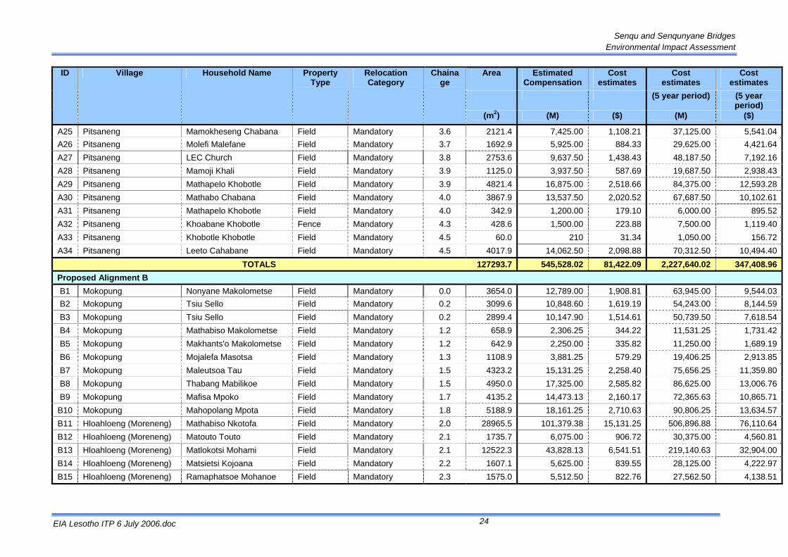
• Interviews were then conducted with these landowners. In addition to this, surveys and consultations were conducted with community leaders and representatives along the proposed Alternative B and C alignments in December 2005 by World Bank and MoPWT representatives. Follow-up surveys were conducted in January 2006 by Africon and MoPWT representatives to identify properties/assets affected by the properties along the proposed new alignments (Table 3-1). Once the final (preferred) alignment had been identified and approved, consultations were held in May 2006 with local chiefs and land owners to confirm the route and affected properties. Community meetings (Pitsos) were held in Seforong and Hloahloeng to present the final alignment to the affected communities and obtain comment and final input. A final list of properties to be affected is presented in Table 3-1 (Alternative C). Property owners and compensation for loss of cultivated land or removal of assets is indicated. Note that no resettlement is required, as no residences are directly impacted on. Policy regarding compensation for loss of communal grazing is under discussion. This may, however, include rehabilitation and reinstatement of currently degraded areas for grazing. Similarly, several cultivated fields will be affected in the Seforong area but no residences requiring resettlement occur along the alignment. It should be noted that strict control and management will be required in these areas where construction activities occur in very close proximity to residences or infrastructure. Some activities – such as blasting or compacting – may result in cracking or other damage to structures in close proximity to the alignment. Allowance should be made in the construction contract for compensation/repairs to such properties.
EIA Lesotho ITP 6 July 2006.doc 20

Senqu and Senqunyane Bridges Environmental Impact Assessment
3.1.3 Community Consultations
Community meetings (Pitsos) – facilitated by experienced Public Participation specialists – were held by Consult 4 in July 2005. These meetings were held to facilitate community participation in order to identify issues related to the proposed road and bridge construction projects as well as provide some feedback on the initial site screens and socio-economic surveys. These meetings were used as an opportunity to verify land ownership and affected properties or assets. These meetings were held in Semonkong, Ha Samuel, Ha Tumo, Ha Lepekola, Lehonyeling and Ha Mosi. Additional Pitsos – facilitated by Dr None Mokitimi, an experienced Public Consultation expert – were then held in May 2006 in Hloahloeng and Seforong once the alignment had been finalised. The meetings served to determine community reaction to the proposed road alignment and re-establish support for the project. Minutes of these meetings are appended (Appendix C).
3.2 Outcomes of the Public Participation Process
Based on the consultations conducted, the following views and concerns were raised:-
• The majority (100%) of the population interviewed felt that the project was necessary for development of the areas.
• The majority felt that the roads project would improve access to education, health or business/market facilities (99%, 98% and 88% respectively).
• Approximately 96% of the population felt that they would support the project, providing fair compensation is paid.
• The majority of community members felt that the project would not affect their quality of life (85%), and should instead provide opportunities to commence small businesses (86%) or provide job opportunities during the construction phase (95%).
• A majority of the population expressed that the proposed roads could increase crime/theft in the area (81%), livestock may be impacted on or killed (47% and 57% respectively) and increased risk of sexually transmitted diseases (59%)
As indicated, however, the majority of the population (97%) viewed the project as beneficial to the socio-economic situation.
3.3 Subsequent Participation Process to be conducted
Final consultations have been conducted to present the project to the communities, and a final draft RAP has been prepared. The final draft RAP for the proposed Senqu and Senqunyane Bridges and interconnecting road is appended (Appendix D)
EIA Lesotho ITP 6 July 2006.doc 21

Senqu and Senqunyane Bridges Environmental Impact Assessment
EIA Lesotho ITP 6 July 2006.doc 22
It is strongly recommended that a steering committee, comprising MoPWT and NES representatives as well as community leaders and representatives, should be established on acceptance of the EMP and RAP to facilitate compensation process prior to the start of construction and continued during the construction phase to allow for community input and feedback during the construction phase.

Senqu and Senqunyane Bridges Environmental Impact Assessment
Table 0-1: List of Properties affected by the preferred alignment
Area Estimated Compensation
Cost estimates
Cost estimates
Cost estimates
(5 year period) (5 year period)
ID Village Household Name Property Type
Relocation Category
Chainage
(m2) (M) ($) (M) ($)
Proposed Alignment A A1 Mokopung Nonyane Makolometse Field Mandatory 0.0 3654.0 12,789.00 1,908.81 63,945.00 9,544.03 A2 Mokopung Tsiu Sello Field Mandatory 0.2 3099.6 10,848.60 1,619.19 54,243.00 8,095.97 A3 Mokopung Tsiu Sello Field Mandatory 0.2 2899.4 10,147.90 1,514.61 50,739.50 7,573.06 A4 Mokopung Mathabiso Makolometse Field Mandatory 1.2 658.9 2,306.25 344.22 11,531.25 1,721.08 A5 Mokopung Makhants'o Makolometse Field Mandatory 1.2 642.9 2,250.00 335.82 11,250.00 1,679.10 A6 Mokopung Mojalefa Masotsa Field Mandatory 1.3 1108.9 3,881.25 579.29 19,406.25 2,896.46 A7 Mokopung Maleutsoa Tau Field Mandatory 1.5 4323.2 15,131.25 2,258.40 75,656.25 11,291.98 A8 Mokopung Thabang Mabilikoe Field Mandatory 1.5 4950.0 17,325.00 2,585.82 86,625.00 12,929.10 A9 Mokopung Mafisa Mpoko Field Mandatory 1.7 4135.2 14,473.13 2,160.17 72,365.63 10,800.84 A10 Mokopung Mahopolang Mpota Field Mandatory 1.8 5188.9 18,161.25 2,710.63 90,806.25 13,553.17 A11 Hloahloeng (Moreneng) Thabiso Nkotofa Field Mandatory 2.0 28965.5 101,379.38 15,131.25 506,896.88 75,656.25 A12 Hloahloeng (Moreneng) Matlokotsi 'Mei Field Mandatory 2.3 12522.3 43,828.13 6,541.51 219,140.63 32,707.56 A13 Hloahloeng (Moreneng) Matouto Touto Field Mandatory 2.1 1735.7 6,075.00 906.72 30,375.00 4,533.58 A14 Hloahloeng (Moreneng) Matlokotsi Mohami Field Mandatory 2.1 12522.3 43,828.13 6,541.51 219,140.63 32,707.56 A15 Hloahloeng (Moreneng) Malimola Moeketsi Field Mandatory 2.2 1189.3 4,162.50 621.27 20,812.50 3,106.34 A16 Hloahloeng (Moreneng) Malefa Lerotholi Field Mandatory 2.4 2550.0 8,925.00 1,332.09 44,625.00 6,660.45 A17 Hloahloeng (Moreneng) Maresetselemang Kuloana Field Mandatory 2.4 1607.1 5,625.00 839.55 28,125.00 4,197.76 A18 Hloahloeng (Moreneng) Morenakemang Moruba Field Mandatory 2.6 2935.7 10,275.00 1,533.58 51,375.00 7,667.91 A19 Hloahloeng (Moreneng) Motlatsi Maroba Field Mandatory 2.7 1725.0 6,037.50 901.12 30,187.50 4,505.60 A20 Hloahloeng (Moreneng) Thabang Mpota Field Mandatory 2.8 289.3 1,012.50 151.12 5,062.50 755.60 A21 Hloahloeng (Moreneng) Matholang Lerotholi Field Mandatory 3.0 3744.6 13,106.25 1,956.16 65,531.25 9,780.78 A22 Hloahloeng (Moreneng) Thabiso Nkotofa Field Mandatory 3.2 2667.9 9,337.50 1,393.66 46,687.50 6,968.28 A23 Hloahloeng (Moreneng) Malefa Lerotholi Field Mandatory 3.3 2946.4 10,312.50 1,539.18 51,562.50 7,695.90 A24 Hloahloeng (Moreneng) a & b Communal Water tank Possible 3.5 100,000.00 14,925.37 14,925.37
EIA Lesotho ITP 6 July 2006.doc 23
Senqu and Senqunyane Bridges Environmental Impact Assessment
Area Estimated Compensation
Cost estimates
Cost estimates
Cost estimates
(5 year period) (5 year period)
ID Village Household Name Property Type
Relocation ChainaCategory ge
(m2) (M) ($) (M) ($)
A25 Pitsaneng Mamokheseng Chabana Field Mandatory 3.6 2121.4 7,425.00 1,108.21 37,125.00 5,541.04 A26 Pitsaneng Molefi Malefane Field Mandatory 3.7 1692.9 5,925.00 884.33 29,625.00 4,421.64 A27 Pitsaneng LEC Church Field Mandatory 3.8 2753.6 9,637.50 1,438.43 48,187.50 7,192.16 A28 Pitsaneng Mamoji Khali Field Mandatory 3.9 1125.0 3,937.50 587.69 19,687.50 2,938.43 A29 Pitsaneng Mathapelo Khobotle Field Mandatory 3.9 4821.4 16,875.00 2,518.66 84,375.00 12,593.28 A30 Pitsaneng Mathabo Chabana Field Mandatory 4.0 3867.9 13,537.50 2,020.52 67,687.50 10,102.61 A31 Pitsaneng Mathapelo Khobotle Field Mandatory 4.0 342.9 1,200.00 179.10 6,000.00 895.52 A32 Pitsaneng Khoabane Khobotle Fence Mandatory 4.3 428.6 1,500.00 223.88 7,500.00 1,119.40 A33 Pitsaneng Khobotle Khobotle Field Mandatory 4.5 60.0 210 31.34 1,050.00 156.72 A34 Pitsaneng Leeto Cahabane Field Mandatory 4.5 4017.9 14,062.50 2,098.88 70,312.50 10,494.40
TOTALS 127293.7 545,528.02 81,422.09 2,227,640.02 347,408.96 Proposed Alignment B B1 Mokopung Nonyane Makolometse Field Mandatory 0.0 3654.0 12,789.00 1,908.81 63,945.00 9,544.03 B2 Mokopung Tsiu Sello Field Mandatory 0.2 3099.6 10,848.60 1,619.19 54,243.00 8,144.59 B3 Mokopung Tsiu Sello Field Mandatory 0.2 2899.4 10,147.90 1,514.61 50,739.50 7,618.54 B4 Mokopung Mathabiso Makolometse Field Mandatory 1.2 658.9 2,306.25 344.22 11,531.25 1,731.42 B5 Mokopung Makhants'o Makolometse Field Mandatory 1.2 642.9 2,250.00 335.82 11,250.00 1,689.19 B6 Mokopung Mojalefa Masotsa Field Mandatory 1.3 1108.9 3,881.25 579.29 19,406.25 2,913.85 B7 Mokopung Maleutsoa Tau Field Mandatory 1.5 4323.2 15,131.25 2,258.40 75,656.25 11,359.80 B8 Mokopung Thabang Mabilikoe Field Mandatory 1.5 4950.0 17,325.00 2,585.82 86,625.00 13,006.76 B9 Mokopung Mafisa Mpoko Field Mandatory 1.7 4135.2 14,473.13 2,160.17 72,365.63 10,865.71 B10 Mokopung Mahopolang Mpota Field Mandatory 1.8 5188.9 18,161.25 2,710.63 90,806.25 13,634.57 B11 Hloahloeng (Moreneng) Mathabiso Nkotofa Field Mandatory 2.0 28965.5 101,379.38 15,131.25 506,896.88 76,110.64 B12 Hloahloeng (Moreneng) Matouto Touto Field Mandatory 2.1 1735.7 6,075.00 906.72 30,375.00 4,560.81 B13 Hloahloeng (Moreneng) Matlokotsi Mohami Field Mandatory 2.1 12522.3 43,828.13 6,541.51 219,140.63 32,904.00 B14 Hloahloeng (Moreneng) Matsietsi Kojoana Field Mandatory 2.2 1607.1 5,625.00 839.55 28,125.00 4,222.97 B15 Hloahloeng (Moreneng) Ramaphatsoe Mohanoe Field Mandatory 2.3 1575.0 5,512.50 822.76 27,562.50 4,138.51
EIA Lesotho ITP 6 July 2006.doc 24

Senqu and Senqunyane Bridges Environmental Impact Assessment
Area Estimated Compensation
Cost estimates
Cost estimates
Cost estimates
(5 year period) (5 year period)
ID Village Household Name Property Type
Relocation ChainaCategory ge
(m2) (M) ($) (M) ($)
B16 Hloahloeng (Moreneng) a & b Communal Water tank Possible 3.6 0.0 100,000.00 14,925.37 14,925.37 B17 Pitsaneng Mamokheseng Chabana Field Mandatory 3.6 2121.4 7,425.00 1,108.21 37,125.00 5,574.32 B18 Pitsaneng Molefi Malefane Field Mandatory 3.7 1692.9 5,925.00 884.33 29,625.00 4,448.20 B19 Pitsaneng LEC Church Field Mandatory 3.8 2753.6 9,637.50 1,438.43 48,187.50 7,235.36 B20 Pitsaneng Mamoji Khali Field Mandatory 3.9 1125.0 3,937.50 587.69 19,687.50 2,956.08 B21 Pitsaneng Mathapelo Khobotle Field Mandatory 3.9 4821.4 16,875.00 2,518.66 84,375.00 12,668.92 B22 Pitsaneng Mathabo Chabana Field Mandatory 4.0 3867.9 13,537.50 2,020.52 67,687.50 10,163.29 B23 Pitsaneng Mathapelo Khobotle Field Mandatory 4.0 342.9 1,200.00 179.10 6,000.00 900.9 B24 Pitsaneng Khoabane Khobotle Fence Mandatory 4.3 428.6 1,500.00 223.88 7,500.00 1,126.13 B25 Pitsaneng Khobotle Khobotle Field Mandatory 4.5 60.0 210 31.34 1,050.00 157.66 B26 Pitsaneng Leeto Cahabane Field Mandatory 4.5 4017.9 14,062.50 2,098.88 70,312.50 10,557.43
TOTALS 98298.2 444,043.64 66,275.17 1,720,218.14 273,159.05 Proposed Alignment C C1 Mokopung Makhati Sello Field Mandatory 0.7 3770.2 13,195.70 1,969.51 65,978.50 9,847.54 C2 Mokopung Makhati Sello Field Mandatory 0.9 1964.7 6,876.45 1,026.34 34,382.25 5,131.68 C3 Hloahloeng (Moreneng) Mabilikoe Mabilikoe Field Mandatory 1.9 2237.9 7,832.65 1,169.05 39,163.25 5,845.26 C4 Hloahloeng (Moreneng) Mojalefa Masoetsa Field Mandatory 1.9 1135.5 3,974.25 593.17 19,871.25 2,965.86 C5 Hloahloeng (Moreneng) Thabang Mabilikoe Field Mandatory 2.0 937.8 3,282.30 489.90 16,411.50 2,449.48 C6 Hloahloeng (Moreneng) Maleutsoa Tau Field Mandatory 2.1 900 3,150.00 470.15 15,750.00 2,350.75 C7 Hloahloeng (Moreneng) Mafisa Mpoka Field Mandatory 2.2 6000 21,000.00 3,134.33 105,000.00 15,671.64 C8 Hloahloeng (Moreneng) Malebuajoang Letsie Field Mandatory 2.4 3297.7 11,541.95 1,722.68 57,709.75 8,613.40 C9 Hloahloeng (Moreneng) Malerato Khafu Field Mandatory 2.4 1273.1 4,455.85 665.05 22,279.25 3,325.26 C10 Hloahloeng (Moreneng) Malebohang Khafu Field Mandatory 2.5 4177.5 14,621.25 2,182.28 73,106.25 10,911.38 C11 Hloahloeng (Moreneng) Masekake Lerotholi Field Mandatory 2.6 4855.5 16,994.25 2,536.46 84,971.25 12,682.28 C12 Hloahloeng (Moreneng) Mathabiso Nkotofa Field Mandatory 2.7 82.1 287.35 42.89 1,436.75 214.44 C13 Hloahloeng (Moreneng) Matlokotsi Mmei Field Mandatory 2.9 4122.3 14,428.05 2,153.44 72,140.25 10,767.20 C14 Hloahloeng (Moreneng) Matouto Touto Field Mandatory 3.0 1703.8 5,963.30 890.04 29,816.50 4,450.22
EIA Lesotho ITP 6 July 2006.doc 25

Senqu and Senqunyane Bridges Environmental Impact Assessment
EIA Lesotho ITP 6 July 2006.doc 26
Area Estimated Compensation
Cost estimates
Cost estimates
Cost estimates
(5 year period) (5 year period)
ID Village Household Name Property Type
Relocation Category
Chainage
(m2) (M) ($) (M) ($)
C15 Hloahloeng (Moreneng) Mamonaheng Sekhae Field Mandatory 3.1 2511.2 8,789.20 1,311.82 43,946.00 6,559.10 C16 Hloahloeng (Moreneng) Mamonaheng Sekhae Field Mandatory 3.3 1421.1 4,973.85 742.37 24,869.25 3,711.83 C17 Hloahloeng (Moreneng) Malepolesa Monale Field Mandatory 3.4 1392.9 4,875.15 727.63 24,375.75 3,638.17 C18 Hloahloeng (Moreneng) Mampobole Ntjelo Field Mandatory 3.4 587.9 2,057.65 307.11 10,288.25 1,535.56 C19 Hloahloeng (Moreneng) Tsosane Mphonyo Field Mandatory 3.7 552.1 1,932.35 288.41 9,661.75 1,442.05 C20 Hloahloeng (Moreneng) Malefa Lerotholi Field Mandatory 4.4 504.2 1,764.70 263.39 8,823.50 1,316.94 C21 Hloahloeng (Moreneng) Communal Water Tank Mandatory 4.4 100,000.00 14,925.37 14,925.37 C22 Pitsaneng Mamokheseng Chabana Field Mandatory 4.9 2266.7 7,933.45 1,184.10 39,667.25 5,920.49 C23 Pitsaneng Molefi Malefane Field Mandatory 5.0 2095.6 7,334.60 1,094.72 36,673.00 5,473.58 C24 Pitsaneng Lesotho Eva Church Field Mandatory 5.0 1649.1 5,771.85 861.47 28,859.25 4,307.35 C25 Pitsaneng Mamoji Khali Field Mandatory 5.1 1289.6 4,513.60 673.67 22,568.00 3,368.36 C26 Pitsaneng Mathapelo Khobotle Field Mandatory 5.1 4218.6 14,765.10 2,203.75 73,825.50 11,018.73 C27 Pitsaneng Mathabo Chabana Field Mandatory 5.1 1234.9 4,322.15 645.10 21,610.75 3,225.49 C28 Pitsaneng Mathapelo Khobotle Field Mandatory 5.3 2661.8 9,316.30 1,390.49 46,581.50 6,952.46 C29 Pitsaneng Khoabane Khobotle Fence Mandatory 5.5 2,500.00 0.82 373.13 C30 Pitsaneng Butleng Chabana Vegetable
P t hMandatory 5.6 346.7 1,213.45 181.11 6,067.25 905.56
C31 Pitsaneng Leeto Chabana Field Mandatory 5.7 805.3 2,818.55 420.68 14,092.75 2,103.40 C32 Pitsaneng Mathabo Chabana Field Mandatory 5.8 549.9 1,924.65 287.26 9,623.25 1,436.31 C33 Seforong Sello Mohapi Field Mandatory 7.3 6781.4 23,734.90 3,542.52 118,674.50 17,712.61 C34 Seforong Mamorapeli Sekoati Field Mandatory 7.9 1576 5,516.00 823.28 27,580.00 4,116.42 C35 Seforong Mapabotso Sekoati Field Mandatory 8.0 1648.3 5,769.05 861.05 28,845.25 4,305.26 C36 Seforong Matsoako Tsoako Field Mandatory 8.0 2727.6 9,546.60 1,424.87 47,733.00 7,124.33 C37 Seforong Mothepu Sekoati Field Mandatory 9.2 1129.5 3,953.25 590.04 19,766.25 2,950.19 C38 Seforong Mampati Sokoati Field Mandatory 9.6 2016.1 7,056.35 1,053.19 35,281.75 5,265.93
TOTALS 76424.6 369,986.10 54,849.50 1,337,430.50 214,915.00

Senqu and Senqunyane Bridges Environmental Impact Assessment
4 ALTERNATIVES TO THE PROJECT
The alternatives assessment has been drafted based on internationally accepted guidelines and methodologies. In accordance with these guidelines, alternative alignments and locations have been investigated, including provision of access to the Clinic at Hloahloeng. Note that ‘No Go’ option was not considered, due to the requirements of the MOPWT
4.1 Alternative to the Location of the Bridges
In the feasibility study conducted by Muir Associates in 1999, it was proposed to construct a single bridge structure on the Senqu River, below the confluence of the Senqunyane River. Although this option was determined to be feasible, it was decided that the final layouts must facilitate increased accessibility to Hloahloeng. It was therefore decided that bridge structures should be therefore constructed on the Senqu and Senqunyane Rivers above the confluence of the two Rivers. This proposal was accepted during the WSP International review. The Senqunyane River crossing was placed at Mokopung approximately 2 km upstream of the confluence, providing access from the Hloahloeng area to a small store. The proposed Senqu River crossing was initially placed approximately 1 km downstream from Pitsaneng. In their review Africon recommended that the bridge be relocated 1 km upstream based on technical and cost as well as provision of access to a wider population
4.2 Alternatives to the Bridge Design and layout
No alternatives to deck design were investigated during the Muir Associates study, which proposed a steel girder with a reinforced deck slab design. WSP international proposed that a viaduct type bridge design be utilised, although this was discarded due to the high technical requirements of the design. No other alternatives to bridge design were investigated.
4.3 Alternatives to connecting road alignment
The initial route alignment (Alternative A – Figure 1-1) passed directly between the two bridges, passing over land predominantly utilised for cultivation and providing easy access to the runway strip at Hloahloeng. However, the subsequent relocation of the Senqu River Bridge required a minor realignment of the proposed connecting road through Hloahloeng (Alternative B). A subsequent minor realignment was then proposed by the MoPWT and the World Bank to facilitate access to the clinic at
EIA Lesotho ITP 6 July 2006.doc 27

Senqu and Senqunyane Bridges Environmental Impact Assessment
Hloahloeng (Alternative C). Alternative A, which would also have required the appropriation of far more cultivated land, was therefore discarded. It is important to note that these alternatives considered are minor variants of the alignment within the same corridor. During the field assessments, it was determined that the minor realignment of the road (from Alternative B to Alternative C) to pass closer to the clinic did not have significant cost implication. Alternative C was therefore investigated as a viable alternative. It is accepted that all proposed alternatives will impact on land use within the study area to a greater or lesser extent, with Alternative C impacting on the least number of cultivated fields and properties (Table 3-1) while improving access to the clinic at Hloahloeng (refer Figure 1-1). The macro impact of each alignment is assessed below (Table 4-1) against identified environmental and social components. Potential positive impacts are assigned a score of 1, no impact a score of 0 and negative impact a score of -1. Note that, where alternatives are assessed in terms of benefit, a similar score is assigned based on most favourable (1) or least favourable (-1).
Table 4-1: Macro Impacts Associated with the proposed alternatives on selected environmental parameters
ENVIRONMENTAL PARAMETER
ALT A
ALT B
ALT C
Biophysical and physical parameters Soil erosion -1 -1 -1 Noise/dust generation -1 -1 -1 Surface water runoff -1 -1 -1 Vegetation cover -1 -1 -1 Sub total -4 -4 -4
Socio-economic parameters Damage to existing infrastructure -1 -1 -1 Sites of cultural interest (graveyards) -1 -1 -1 Increase in Crime -1 -1 -1 Transmission of STI’s -1 -1 -1 Job creation 1 1 1 Loss of land tenure -1 -1 -1 Increased accessibility 1 1 1 Reduced travel times 1 1 1 Upgrading of infrastructure 1 1 1 Safety on road 1 1 1 Access to Clinic at Ha Nkau -1 0 1 Sub total -1 0 1
Institutional arrangement Construction cost 1 0 -1 Compensation costs -1 0 1
EIA Lesotho ITP 6 July 2006.doc 28

Senqu and Senqunyane Bridges Environmental Impact Assessment
Implementation of the EMP 0 0 0 Sub total 0 0 0 Total -5 -4 -3
From Table 4-1, it is clear that all three proposed alternative alignments will have similar positive or negative impacts on the receiving social, physical and biophysical environments. Principally, Alternative C has the most benefit in terms of improving access to the clinic at Hloahloeng. At the same time, the proposed alternative will pass over fewer cultivated fields, thus the impact on Land Tenure can be reduced, and in turn reduce the monetary amount required for compensation. Alternative C was therefore accepted as the preferred route alignment. A detailed impact assessment, indicating significance of the proposed macro as well as micro impacts which can be associated with the construction and operation of a road along the preferred alignment, is presented below. Note that the detailed assessment only describes impacts associated with alternative C.
EIA Lesotho ITP 6 July 2006.doc 29

Senqu and Senqunyane Bridges Environmental Impact Assessment
5 EIA METHODOLOGY AND APPROACH
5.1 Introduction
One of the objectives of this study is to identify and quantify the potential positive and negative impacts which the proposed roads will have on the receiving biophysical and socio-economic environment. These impacts have been generated and identified by field investigation, specialist studies and evaluation. Input from the public and various authorities consulted during this process are also incorporated. The negative impacts will be mitigated to minimise their significance and the positive impacts will be enhanced as far as possible. Methods for identification of environmental impacts can assist in specifying the range of impacts that may occur, including their spatial dimensions and time period. Identification methods answer questions concerning the components of the project and what elements of the environment may be affected by these components.
FUNCTION METHODOLOGY Identification • Description of the existing environmental system
• Determination of the components of the project • Definition of the environment modified by the project
Prediction • Identification of environmental modifications that may be significant
• Forecasting of the quantity and/or spatial dimensions of change in the identified environment
• Estimation of the probability that the impact (environmental change) will occur (time period)
Evaluation • Determination of the incidence of costs and benefits to user groups and populations affected by the project
• Specification and comparison of the trade offs (costs or effects being balanced) between various alternatives
5.2 Evaluation Methods
While the use of multiple evaluation methods may seem excessively demanding, it is usually obtaining the inputs to evaluation methods that is demanding. Once these inputs are available, application of the methods themselves is often relatively straightforward. More than 50 impact analysis methodologies have been developed internationally. Of those considered, the two primary methods and variations on them selected in this instance are checklists and matrices, since these are mostly applicable. Checklists can be divided into simple, descriptive, scaling, and scaling-weighting checklists. Matrices are subdivided into simple and stepped matrices. The key point
EIA Lesotho ITP 6 July 2006.doc 30

Senqu and Senqunyane Bridges Environmental Impact Assessment
with regard to all environmental impact analysis methodologies is that there are useful tools for examining relative environmental impacts of alternatives. They represent a tool that must be applied with professional judgement, and their results must also be interpreted using professional judgement. These are evaluated in terms of the following:- • Nature and Extent
DESIGNATION DESCRIPTION Immediate The impact restricted to the activity site Local The impact extends beyond the activity area/boundary into the surrounds Regional ay extend on adjacent/surrounding communities The impact mNational The impact may extend over regional/international boundaries
Duration •DESIGNATION DESCRIPTION
T The impact is predominantly events such as high linked to climaticransient winds/high rainfall etc. Short The impact only arises and persists through the construction phase
Medium e after rehabilitation/decommissioning The impact persists through the construction and operational phases, but ceasThe impact persists after the rehabilitation/decommissioning phase will cease as a result of the re-establishment of natural ecosy
but stem Long
processes Permanent The impact is permanent
• and int Status ensity
DESIGNATION DESCRIPTION
Low Cultural and Ecosystem processes are not affected, or can be maintained at a high level of functionality ersible, and may require . Impacts are revmitigation
Medium h the implementation of adequate mitigation Cultural and Ecosystem processes are impacted on, but can be functionally maintained througmeasures. Impacts, while severe, can be reversed
High ay Cultural and Ecosystem processes are irreversibly impacted on, and m
cease completely. Mitigation must be implemented to reduce these to within acceptable limits
• Probability
DESIGNATION DESCRIPTION Improbable It is unlikely that the impact will arise Prob There is a 30% likelihood ing able of the impact arisHighly probable There is a 75% likelihood of the impact arising Definite The impact will occur
The overall Significance determined, based on the above four riteria, and designated as described below.
of the impact is thenc
DESIGNATION DESCRIPTION
EIA Lesotho ITP 6 July 2006.doc 31
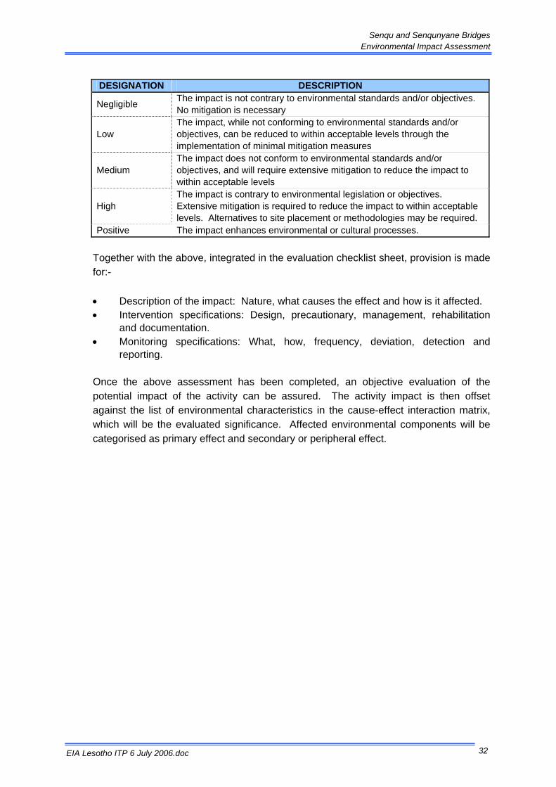
Senqu and Senqunyane Bridges Environmental Impact Assessment
DESIGNATION DESCRIPTION The impact is not contrary to ndards and/or objectives. environmental staNegligible No mitigation is necessary
Low mental standards and/or The impact, while not conforming to environ
objectives, can be reduced to within acceptable levels through the implementation of minimal mitigation measures
Medium ards and/or
The impact does not conform to environmental standobjectives, and will require extensive mitigation to reduce the impact towithin acceptable levels
High ronmental legislation or objectives.
e ired.
The impact is contrary to enviExtensive mitigation is required to reduce the impact to within acceptabllevels. Alternatives to site placement or methodologies may be requ
Positive The impact enhances environmental or cultural processes. Together with the above, integrated in the evaluation checklist sheet, provision is made
r:-
Description of the impact: Nature, what causes the effect and how is it affected. Intervention specifications: Design, precautionary, management, rehabilitation
Once the above assessment has been completed, an objective evaluation of the otential impact of the activity can be assured. The activity impact is then offset
fo • •
and documentation. • Monitoring specifications: What, how, frequency, deviation, detection and
reporting.
pagainst the list of environmental characteristics in the cause-effect interaction matrix, which will be the evaluated significance. Affected environmental components will be categorised as primary effect and secondary or peripheral effect.
EIA Lesotho ITP 6 July 2006.doc 32

Senqu and Senqunyane Bridges Environmental Impact Assessment
6 IMPACT DESCRIPTION
6.1 Introduction
The Impact assessment conducted below pertains specifically to potential impacts – positive / negative or direct / indirect – which may arise at any phase of the development of the proposed two bridges and connecting road. Two phases have been identified in which significant impacts may arise:-
• Construction phase • Operational phase
A description of the Macro and Micro impacts which can be expected to arise as a result of construction and operation phase activities associated with the road construction project is presented below. Note that the detailed EIA (Micro impacts) are only presented for the proposed (accepted) Alternative C alignment. Mitigation measures are presented in the assessment tables below. The Planning and Development phase, as well as the closure phase, have been discarded since no impacts will arise during these phases due to the nature of the project.
6.2 Macro Impacts Associated with the Construction Phase
The principal activities which will occur during the construction involve:-
1) Establishment of the construction camp 2) Clearing of vegetation along the alignment 3) Topsoil stripping/filling for cut/fill along the alignment 4) Construction of stormwater drainage features 5) Establishment of bridge foundations 6) Placement of the bridge platform 7) Placement and compaction of pavement layers
6.2.1 Air Quality
Environmental Description Dust generation and Air quality: Negative Impact Impact Descriptions Construction activities such as clearing and grubbing, topsoil removal, trenching and storage as well as the movement of construction vehicles generate dust. The dust will influence the air quality in the immediate vicinity of the construction activity.
EIA Lesotho ITP 6 July 2006.doc 33
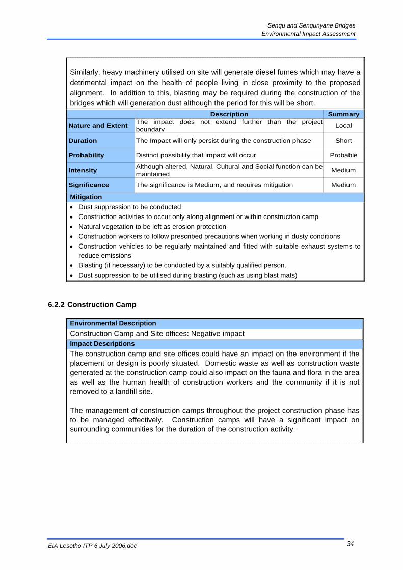
Senqu and Senqunyane Bridges Environmental Impact Assessment
Similarly, heavy machinery utilised on site will generate diesel fumes which may have a detrimental impact on the health of people living in close proximity to the proposed alignment. In addition to this, blasting may be required during the construction of the bridges which will generation dust although the period for this will be short.
Description Summary
Nature and Extent The impact does not extend further than the projectboundary Local
Duration The Impact will only persist during the construction phase Short
Probability Distinct possibility that impact will occur Probable
Intensity Although altered, Natural, Cultural and Social function can bemaintained Medium
Significance The significance is Medium, and requires mitigation Medium
Mitigation • Dust suppression to be conducted • Construction activities to occur only along alignment or within construction camp • Natural vegetation to be left as erosion protection • Construction workers to follow prescribed precautions when working in dusty conditions • Construction vehicles to be regularly maintained and fitted with suitable exhaust systems to
reduce emissions • Blasting (if necessary) to be conducted by a suitably qualified person. • Dust suppression to be utilised during blasting (such as using blast mats)
6.2.2 Construction Camp
Environmental Description Construction Camp and Site offices: Negative impact Impact Descriptions The construction camp and site offices could have an impact on the environment if the placement or design is poorly situated. Domestic waste as well as construction waste generated at the construction camp could also impact on the fauna and flora in the area as well as the human health of construction workers and the community if it is not removed to a landfill site. The management of construction camps throughout the project construction phase has to be managed effectively. Construction camps will have a significant impact on surrounding communities for the duration of the construction activity.
EIA Lesotho ITP 6 July 2006.doc 34

Senqu and Senqunyane Bridges Environmental Impact Assessment
Description Summary
Nature and Extent The impact does not extend further than the projectboundary Local
Duration The Impact will only persist during the construction phase Short
Probability It is highly likely that the impacts will occur Highly Probable
Intensity Although altered, Natural, Cultural and Social function can bemaintained Medium
Significance The significance is Low Low
Mitigation • The placement of the construction camps must be negotiated with the local land owners and
community leaders • The construction camps must be placed on a disturbed piece of land • Indigenous vegetation must not be disturbed if at all possible • The contractor must supply the workers with firewood or preferably gas cooking appliances,
to ensure that wood is not harvested from the surrounding vegetation
6.2.3 Disturbance of Hydrological Patterns
Environmental Description Soil, surface and groundwater pollution: Negative impacts Impact Descriptions Daily natural water resources play a very significant part in the biophysical and human environment. Construction of the bridges – specifically the placement of the pillars – may require the diversion of the river around the drilling site. This will impact on flow within the Senqu and Senqunyane Rivers.
Description Summary
Nature and Extent The impact does not extend further than the project boundary Local
Duration The Impact will only persist during the construction phase Short
Probability It is highly likely that the impacts will occur Highly Probable
Intensity Although altered, Natural, Cultural and Social function can bemaintained Medium
Significance The significance is Medium, and requires mitigation Medium
Mitigation • The road surface should be maintained regularly to minimise accidents which result in
spillage of hazardous materials • Water user licences (if applicable) will be obtained from Department of Water Affairs and
Forestry for water required during the maintenance use • A suitable hazmat response programme to be initiated during the maintenance phase, to
reduce the probability of the accidental hazardous material spills from entering the natural environment
EIA Lesotho ITP 6 July 2006.doc 35

Senqu and Senqunyane Bridges Environmental Impact Assessment
6.2.4 Flora and Fauna
Environmental Description Removal of vegetation during road construction: Negative impact Impact Descriptions Road construction activities will have resulted in loss of vegetation along new routes, particularly natural vegetation associated with the approaches and departures to the proposed bridges. Although the plant and animal communities within the road and bridge alignments are not considered sensitive, the loss of biodiversity in general is contrary to national and international objectives.
Description Summary
Nature and Extent The impact does not extend further than the projectboundary Local
Duration The impact will persist into operational phase Medium
Probability It is highly likely that the impacts will occur Highly Probable
Intensity Although altered, Natural, Cultural and Social function can bemaintained Medium
Significance The significance is Medium, and requires mitigation Medium
Mitigation • Movement of machinery must be restricted to demarcated areas only • Indigenous vegetation must not be disturbed outside of the surveyed alignment and bridge
sites • No harvesting of natural resources will be permitted • Fines to be imposed for infractions relating to habitat conservation and disturbance of natural
vegetation
6.2.5 Erosion along Alignment / River Crossings
Environmental Description Erosion: Negative impacts Impact Descriptions Construction activities such as clearing and grubbing, topsoil removal, trenching and storage of materials could cause erosion during rainstorms or flooding. Erosion of the soil or run-off from construction materials could cause siltation of the water bodies in the surrounding area. As indicated, the soils occurring within the study area are highly erodable.
EIA Lesotho ITP 6 July 2006.doc 36

Senqu and Senqunyane Bridges Environmental Impact Assessment
Description Summary
Nature and Extent The impact may extend past regional / Internationalboundaries National
Duration The impact is permanent Permanent
Probability The impact will definitely occur Definite
Intensity Natural, Cultural and Social function is irrevocably altered,and may temporarily or permanently cease. High
Significance The significance is High. Extensive mitigation or designintervention is required High
Mitigation • The location of topsoil and other construction material stockpiles must be carefully considered
to minimise siltation / pollution of the Senqu or Senqunyane • Stockpile areas must be clearly demarcated and stabilised to ensure minimum erosion during
rainstorms • Construction activities to disturb as small an area as possible – natural vegetation to be left
as erosion protection as far as possible • Exposed areas which will not be utilised after the construction phase must be rehabilitated • Construction vehicles must be maintained regularly and services conducted in clearly
demarcated service areas designed to contain fuel and oil spillages directly or indirectly onto the soil
6.2.6 Noise Pollution
Environmental Description Noise generation: Negative impact Impact Descriptions Noise is generated by construction activities such as clearing and grubbing, layer works, trenching and cement / asphalt batching. Construction vehicles generate noise. Blasting (if required) will generate noise.
Description Summary
Nature and Extent The impact may extend into surrounding communities Regional
Duration The Impact will only persist during the construction phase Short
Probability It is highly likely that the impacts will occur Highly Probable
Intensity Natural, Cultural or Social functions are unaffected by theimpact Low
Significance The significance is Medium, and requires mitigation Medium
Mitigation • Construction workers to adhere to health and safety standards as prescribed in the EMP • Working hours will be restricted to reduce impacts on the neighbouring residences at night • Blasting will be conducted on a fixed schedule, only during working hours • Local communities to be informed of blasting times • Blasting to be conducted only be a certified contractor, using minimal material to obtain
maximum results
EIA Lesotho ITP 6 July 2006.doc 37
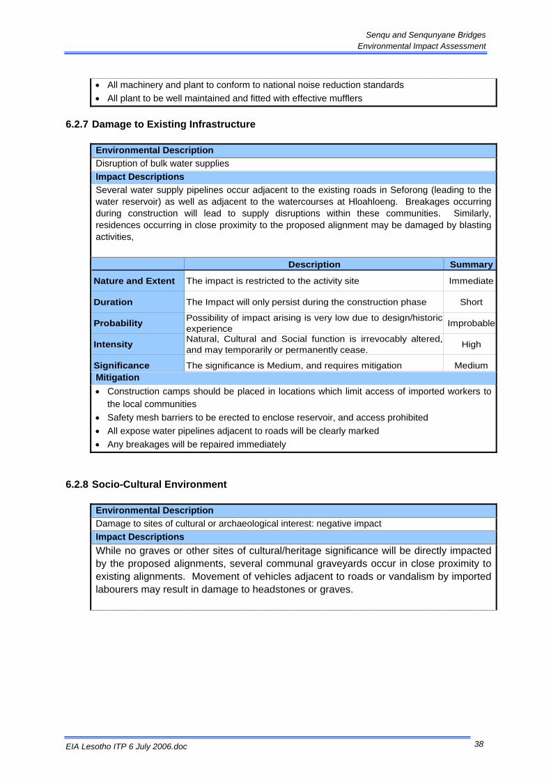
Senqu and Senqunyane Bridges Environmental Impact Assessment
• All machinery and plant to conform to national noise reduction standards • All plant to be well maintained and fitted with effective mufflers
6.2.7 Damage to Existing Infrastructure
Environmental Description Disruption of bulk water supplies Impact Descriptions Several water supply pipelines occur adjacent to the existing roads in Seforong (leading to the water reservoir) as well as adjacent to the watercourses at Hloahloeng. Breakages occurring during construction will lead to supply disruptions within these communities. Similarly, residences occurring in close proximity to the proposed alignment may be damaged by blasting activities,
Description Summary
Nature and Extent The impact is restricted to the activity site Immediate
Duration The Impact will only persist during the construction phase Short
Probability Possibility of impact arising is very low due to design/historicexperience Improbable
Intensity Natural, Cultural and Social function is irrevocably altered,and may temporarily or permanently cease. High
Significance The significance is Medium, and requires mitigation MediumMitigation • Construction camps should be placed in locations which limit access of imported workers to
the local communities • Safety mesh barriers to be erected to enclose reservoir, and access prohibited • All expose water pipelines adjacent to roads will be clearly marked • Any breakages will be repaired immediately
6.2.8 Socio-Cultural Environment
Environmental Description Damage to sites of cultural or archaeological interest: negative impact Impact Descriptions While no graves or other sites of cultural/heritage significance will be directly impacted by the proposed alignments, several communal graveyards occur in close proximity to existing alignments. Movement of vehicles adjacent to roads or vandalism by imported labourers may result in damage to headstones or graves.
EIA Lesotho ITP 6 July 2006.doc 38

Senqu and Senqunyane Bridges Environmental Impact Assessment
Description Summary
Nature and Extent The impact does not extend further than the projectboundary Local
Duration The Impact will only persist during the construction phase Short
Probability Possibility of impact arising is very low due to design/historicexperience Improbable
Intensity Natural, Cultural and Social function is irrevocably altered,and may temporarily or permanently cease. High
Significance The significance is Medium, and requires mitigation Medium
Mitigation • Construction camps should be placed in locations which limit access of imported workers to
the local communities • Fences/safety barriers to be erected between construction activities and graves/graveyards • A minimum 15 m buffer to be placed between safety barrier and graves / outer graves in
graveyard • Labourers to be instructed in the consequences of intentional vandalism
Environmental Description Increase in Crime / Theft Impact Descriptions The use of imported labour may lead to increased theft from local communities during the construction phase. Stock theft in particular may become problematic. The impact has a Medium significance.
Description Summary
Nature and Extent The impact does not extend further than the projectboundary Local
Duration The Impact will only persist during the construction phase Short
Probability Distinct possibility that impact will occur Probable
Intensity Although altered, Natural, Cultural and Social function can bemaintained Medium
Significance The significance is Medium, and requires mitigation Medium
Mitigation • The contractor to educate / warn labourers as to the ramifications of theft • The contractor and MOPWT to establish cordial relationships with local communities and
local Chiefs / Headmen to facilitate criminal investigations of stock / theft Environmental Description Health implications: Negative social impact Impact Descriptions Easier access into once relatively remote areas has the probability of increasing the influx of more people into the area. Rural communities, whose lifestyles consist to a large extent on a traditional lifestyle, will be more susceptible to outside influences. Diseases such as HIV/AIDS are a reality and can significantly impact on rural communities.
EIA Lesotho ITP 6 July 2006.doc 39

Senqu and Senqunyane Bridges Environmental Impact Assessment
Similarly, the influx of skilled and unskilled work force during the construction phase will impact negatively on local community dynamics and function if not managed effectively. Aspects such as the placement of the construction camps to limit contact with the local community will be further explored in the mitigation phase of the project. The significance of this impact can, however, largely be reduced through the acquirement of labour from surrounding communities.
Description Summary
Nature and Extent The impact may extend past regional / Internationalboundaries National
Duration The Impact will only persist during the construction phase Short
Probability It is highly likely that the impacts will occur Highly Probable
Intensity Natural, Cultural and Social function is irrevocably altered,and may temporarily or permanently cease. High
Significance The significance is High. Extensive mitigation or designintervention is required High
Mitigation • Construction camps should be placed in locations which limit access of imported workers to
the local communities • NGO’s/clinics should be consulted, and provision made for health and healthcare training and
education for labourers • Labour should be drawn as far as possible from local/surrounding communities to reduce
number of migrant/imported labourers on site • Education programs should be implemented to educate construction workers as well as the
surrounding communities on potential communicable diseases (STD’s/HIV/AID’s etc) associated with the influx of foreign / migrant workers
Environmental Description Creation of employment opportunities: Positive impact Impact Descriptions A significant impact is the short-term wealth expectation created by any development project. Unskilled labour should be used during the construction process, and if possible labour intensive construction methods employed. This is typically required by the MoPWT, and facilitates adequate transfer of skills. Based on current employment and skill levels within the local communities, a significant number of skilled positions, such as machinery operators, can be filled from within local communities.
Description Summary
Nature and Extent
Duration
Probability
Intensity
Significance The impact is Positive PositiveSustainability Actions • Local unskilled labour (women included) should be used as far as possible during the
EIA Lesotho ITP 6 July 2006.doc 40

Senqu and Senqunyane Bridges Environmental Impact Assessment
construction of the road through a local labour recruitment plan • Mechanisms and structures to ensure the appropriate development and transfer of skills to
the local community should be established • Labour intensive construction methods should be employed where possible • An overall development / land use plan for the surrounding area should be implemented to
ensure that potential future conflicts are identified and mitigated • The development / land use plan to be implemented and monitored by the Environment and
Social unit of the MoPWT
6.3 Macro Impacts Associated with the Operational Phase
Principle activities involved during the operational phase can include:- 1) Maintenance of road surfaces and shoulders along the alignment 2) Repair/rehabilitation of storm water management structures/erosion control
structures 3) Routine inspection of the road surface/associated structures
6.3.1 Air Quality
Environmental Description Dust generation and Air quality: Negative Impact Impact Descriptions Potential road users could generate dust if the road surface or shoulders are not maintained. With the construction of improved road infrastructure, it can be expected that the vehicle emissions level will decrease, due to more efficient vehicle operation and reduced stop-start traffic.
Description Summary
Nature and Extent The impact does not extend further than the projectboundary Local
Duration The impact will persist into operational phase Medium
Probability Possibility of impact arising is very low due to design/historicexperience Improbable
Intensity Although altered, Natural, Cultural and Social function can bemaintained Medium
Significance The significance is Medium, and requires mitigation Medium
Mitigation • The road surface and shoulders to be maintained regularly to eliminate potholes and
reduce dust entrainment
6.3.2 Noise Pollution
Environmental Description Noise generation: Negative impact
EIA Lesotho ITP 6 July 2006.doc 41

Senqu and Senqunyane Bridges Environmental Impact Assessment
Impact Descriptions Noise will typically be an impact associated with the road as long as it is in operation. It is not envisaged that the daily traffic flow will increase to such an extent that the noise levels will become problematic. Improvement in the quality of the road surface will most likely result in a decrease of noise although tire noise generated by higher travelling speeds may result in nuisance noise.
Description Summary
Nature and Extent The impact does not extend further than the projectboundary Local
Duration The impact will persist into operational phase Medium
Probability It is highly likely that the impacts will occur Highly Probable
Intensity Natural, Cultural or Social functions are unaffected by theimpact Low
Significance The significance is Medium, and requires mitigation Medium
Mitigation • Regular maintenance of the road to ensure road safety and to reduce noise as a
result of potholes and vehicles reducing speed to avoid them • Noise in significantly sensitive cultural and social areas can be mitigated by berms
and planting of vegetation screens where and if required such as between the road and schools/community meeting places
• Speed limits to be enforced along roads to minimise tire noise, particularly where the road passes close to residences/community structures
6.3.3 Disturbance of Surface Flow
Environmental Description Soil, surface and groundwater pollution: Negative impacts Impact Descriptions Daily natural water resources play a very significant part in the biophysical and human environment. The most significant impact will be a change in the surface water velocity (run-off), flow quantities and water quality due to construction of impervious surfaces. Note that the bridge structure design, which utilise pillars, is not expected to have a significant impact on hydrological patterns within the Senqu or Senqunyane River. Pollution of the water sources could impact on the health of the neighbouring community, construction and facility workers.
EIA Lesotho ITP 6 July 2006.doc 42

Senqu and Senqunyane Bridges Environmental Impact Assessment
Description Summary
Nature and Extent The impact may extend into surrounding communities Regional
Duration The impact is permanent Permanen
Probability It is highly likely that the impacts will occur Highly Probable
Intensity Although altered, Natural, Cultural and Social function can bemaintained Medium
Significance The significance is High. Extensive mitigation or designintervention is required High
Mitigation • The road surface should be maintained regularly to minimise accidents which result in
spillage of hazardous materials • Suitable erosion control mechanisms to be instituted in the design and layout of the bridges
and road to reduce silt loads in surface water runoff. • A suitable hazmat response programme to be initiated during the maintenance phase, to
reduce the probability of the accidental hazardous material spills from entering the natural environment
6.3.4 Socio-Cultural Environment
Environmental Description Loss of land tenure and livelihoods: Negative impact Impact Descriptions The proposed bridges and connecting road will result in sterilisation and loss of ground currently utilised for cultivation which, in turn, impacts on local livelihoods and income. In addition, the construction of the bridges will negate the need for the private ferry service located at the Senqu bridge site. Note, however, that no residences will be impacted on thus no involuntary resettlement is necessary
Description Summary
Nature and Extent The impact does not extend further than the project boundary Local
Duration The impact is permanent Permanen
Probability It is highly likely that the impacts will occur Highly Probable
Intensity Although altered, Natural, Cultural and Social function can bemaintained Medium
Significance The significance is High. Extensive mitigation or designintervention is required High
Sustainability Actions • On finalisation of the alignments, all properties which will be affected must be surveyed,
owners identified and provision for compensation made in terms of the Draft RAP (Appendix E). Note that provisional identification has been completed for properties along the proposed alignment (Table 3-1)
• Compensation to be conducted in accordance with the Transport Sector Compensation and
EIA Lesotho ITP 6 July 2006.doc 43

Senqu and Senqunyane Bridges Environmental Impact Assessment
Resettlement Policy Framework (Consult 4, September 2003) and Final Resettlement Action Plan
• When drawing up the specifications for the construction contract, clauses addressing environmental and social impacts must be specified and adhered to
Environmental Description Increased accessibility: Positive impact Impact Descriptions Construction of the two bridges will result in improved access to the Hloahloeng area, particularly between Mokopung, Ha Nkau, Pitsaneng and Seforong. This will improve accessibility of local communities to health, education and market/business facilities. Easier and efficient access to these facilities will greatly improve the quality of life for surrounding and local communities.
Description Summary
Nature and Extent
Duration
Probability
Intensity
Significance The impact is Positive Positive
Sustainability Actions No actions necessary
Environmental Description Reduced travel times and operating cost: Positive impact Impact Descriptions One of the most significant benefits of improved transport infrastructure is reduced travel times. This will constitute tremendous cost savings and production turn-around times, which can in turn stimulate local and regional economies. Vehicle operating costs in terms of maintenance and energy inputs will be decreased through the upgrade, once again contributing to stimulating efficiency and cost savings.
Description Summary
Nature and Extent
Duration
Probability
Intensity
Significance The impact is Positive Positive
Sustainability Actions • Pavement layers and bridge structures must be regularly maintained • Ensure that erosion is minimal during the wet season to improve road safety
EIA Lesotho ITP 6 July 2006.doc 44

Senqu and Senqunyane Bridges Environmental Impact Assessment
• Areas where the road passes through social or cultural gathering places should be clearly marked with road signage and sufficient road crossings should be introduced
Environmental Description Upgrading of current infrastructure: Positive impact Impact Descriptions The project will upgrade the existing poor infrastructure to an acceptable level through upgrading of existing routes and the construction of new routes. Erosion control measures will be implemented where required and rehabilitation measures instituted. Existing stormwater management structures can be rehabilitated to improve storm water management.
Description Summary
Nature and Extent
Duration
Probability
Intensity
Significance The impact is Positive Positive
Sustainability Action • Erosion control measures must be implemented where required and rehabilitation
measures instituted • Effective storm water management systems and structures must be put in place and
existing structures to be retained must be rehabilitated • Stormwater must be managed to minimise erosion and siltation of aquatic systems
Environmental Description Safety along the alignment: Negative and Positive social implication Impact Descriptions Poorly maintained and un-surfaced roads impact significantly on the safety of vehicle users, especially of pedestrians and private vehicles as are found in the study area. Upgrading of the route alignment and surface will invariably increase the design speed of the road, and vehicle travel speeds can be expected to increase dramatically. Conversely, increased vehicle speeds will impact negatively on current pedestrian road users.
Description Summary
Nature and Extent The impact does not extend further than the projectboundary Local
Duration The impact will persist into operational phase Medium
Probability It is highly likely that the impacts will occur Highly Probable
Intensity Although altered, Natural, Cultural and Social function can bemaintained Medium
Significance The significance is Medium, and requires mitigation Medium
EIA Lesotho ITP 6 July 2006.doc 45
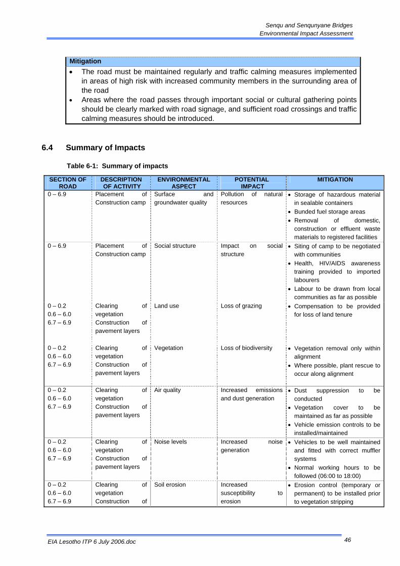
Senqu and Senqunyane Bridges Environmental Impact Assessment
Mitigation • The road must be maintained regularly and traffic calming measures implemented
in areas of high risk with increased community members in the surrounding area of the road
• Areas where the road passes through important social or cultural gathering points should be clearly marked with road signage, and sufficient road crossings and traffic calming measures should be introduced.
6.4 Summary of Impacts
Table 6-1: Summary of impacts
SECTION OF ROAD
DESCRIPTION OF ACTIVITY
ENVIRONMENTAL ASPECT
POTENTIAL IMPACT
MITIGATION
0 – 6.9 Placement of Construction camp
Surface and groundwater quality
Pollution of natural resources
• Storage of hazardous material in sealable containers
• Bunded fuel storage areas • Removal of domestic,
construction or effluent waste materials to registered facilities
0 – 6.9 Placement of Construction camp
Social structure Impact on social structure
• Siting of camp to be negotiated with communities
• Health, HIV/AIDS awareness training provided to imported labourers
• Labour to be drawn from local communities as far as possible
0 – 0.2 0.6 – 6.0 6.7 – 6.9
Clearing of vegetation Construction of pavement layers
Land use Loss of grazing • Compensation to be provided for loss of land tenure
0 – 0.2 0.6 – 6.0 6.7 – 6.9
Clearing of vegetation Construction of pavement layers
Vegetation Loss of biodiversity • Vegetation removal only within alignment
• Where possible, plant rescue to occur along alignment
0 – 0.2 0.6 – 6.0 6.7 – 6.9
Clearing of vegetation Construction of pavement layers
Air quality
Increased emissions and dust generation
• Dust suppression to be conducted
• Vegetation cover to be maintained as far as possible
• Vehicle emission controls to be installed/maintained
0 – 0.2 0.6 – 6.0 6.7 – 6.9
Clearing of vegetation Construction of pavement layers
Noise levels Increased noise generation
• Vehicles to be well maintained and fitted with correct muffler systems
• Normal working hours to be followed (06:00 to 18:00)
0 – 0.2 0.6 – 6.0 6.7 – 6.9
Clearing of vegetation Construction of
Soil erosion Increased susceptibility to erosion
• Erosion control (temporary or permanent) to be installed prior to vegetation stripping
EIA Lesotho ITP 6 July 2006.doc 46

Senqu and Senqunyane Bridges Environmental Impact Assessment
EIA Lesotho ITP 6 July 2006.doc 47
pavement layers 0 – 0.2 0.6 – 6.0 6.7 – 6.9
Clearing of vegetation Construction of pavement layers
Socio-economic Loss of income Job creation Increased STI’s due to influx of migrant workers
• Compensation to be provided for loss of land tenure
• Local labour to be utilised • HIV/AID’s and general health
awareness training to be provided
• Environmental awareness training to be provided
0 – 0.6 6.0 – 6.7
Placement of pillars Placement of slabs
Aquatic/bank vegetation
Loss of biodiversity • Vegetation to be cleared in alignment only
• If possible, plant rescue to be conducted along alignment
0 – 0.6 6.0 – 6.7
Placement of pillars Placement of slabs
Surface water flow Alteration of surface water flow patterns
• Placement of pillars to occur during low flow period (if possible)
• Surface are of pillars to be minimised
• Pillar shape to facilitate flow around pillar and prevent build-up of material
0 – 0.6 6.0 – 6.7
Placement of pillars Placement of slabs
Water quality Increased sedimentation due to erosion
• Pillar shape to facilitate flow around pillar and prevent build up of material
6.5 Environmental Impact Checklists
Micro impacts, which may impact on specific environmental features along all proposed alignments, are indicated below in Table 6-2. A photographic summary of the environmental features impacted on at specific points along the alignments are provided in Figures 6-1 to 6-4.

Senqu and Senqunyane Bridges Environmental Impact Assessment
Table 6-2: Micro Impact Tables - Senqu and Senqunyane Bridges and Connecting Road
ENVIRONMENTAL FACTOR Air Water Land Fauna and
Flora Human use Quality of life Impact Cost
w/out mitigation
RE
FER
EN
CE
CH
AIN
AG
E
FEATURE / ACTIVITY DESCRIPTION Dus
t lev
el
Em
issi
ons
Sur
face
wat
er fl
ows
Sur
face
wat
er q
ualit
y
Eros
ion/
depo
sitio
n
Dra
inag
e pa
ttern
s
Slo
pe s
tabi
lity
Sens
itive
hab
itats
Terre
stria
l flo
ra/fa
una
Aqu
atic
flor
a/fa
una
Infra
stru
ctur
e
Pub
lic fa
cilit
ies
Agric
ultu
re
Live
stoc
k
Fore
stry
Econ
omic
Indu
stry
/ co
mm
erce
Res
iden
tial
Soc
ial s
truct
ure
Pub
lic h
ealth
and
saf
ety
Fam
ily fi
nanc
es
Noi
se le
vel
cultu
ral h
erita
ge
Land
scap
e qu
ality
Dur
atio
n
Ext
ent
Pro
babi
lity
Inte
nsity
SIG
NIF
ICA
NC
E
Com
mun
ity
Pro
ject
cos
t
1 0.0 Residence within close proximity to proposed alignment X X X X X X X X X X P L H H M X
2 0.1 Residence within close proximity to proposed alignment X X X X X X X X X X P L H H M X
3 0.7 Cultivated Field: Loss of livelihood and / or income X X X X X X P L H H H X
4 0.9 Bridge bank habitus: Loss of vegetation / Grazing X X X X X X X P L H M M X
5 0.9 Cultivated Field: Loss of livelihood and / or income X X X X X X P L H H H X
6 1.3 Alignment habitus: Loss of vegetation / Grazing X X X X P L H L L
7 1.9 Cultivated Field: Loss of livelihood and / or income X X X X X X P L H H H X
8 1.9 Cultivated Field: Loss of livelihood and / or income X X X X X X P L H H H X
9 2.0 Cultivated Field: Loss of livelihood and / or income X X X X X X P L H H H X
10 2.1 Cultivated Field: Loss of livelihood and / or income X X X X X X P L H H H X
11 2.2 Alignment habitus: Loss of vegetation / Grazing X X X X P L H L L
12 2.2 Cultivated Field: Loss of livelihood and / or income X X X X X X P L H H H X
13 2.4 Cultivated Field: Loss of livelihood and / or income X X X X X X P L H H H X
14 2.4 Cultivated Field: Loss of livelihood and / or income X X X X X X P L H H H X
15 2.5 Cultivated Field: Loss of livelihood and / or income X X X X X X P L H H H X
16 2.6 Cultivated Field: Loss of livelihood and / or income X X X X X X P L H H H X
17 2.7 Cultivated Field: Loss of livelihood and / or income X X X X X X P L H H H X
18 2.9 Cultivated Field: Loss of livelihood and / or income X X X X X X P L H H H X
19 3.0 Cultivated Field: Loss of livelihood and / or income X X X X X X P L H H H X
20 3.1 Cultivated Field: Loss of livelihood and / or income X X X X X X P L H H H X
21 3.3 Cultivated Field: Loss of livelihood and / or income X X X X X X P L H H H X
22 3.4 Cultivated Field: Loss of livelihood and / or income X X X X X X P L H H H X
23 3.4 Cultivated Field: Loss of livelihood and / or income X X X X X X P L H H H X
24 3.7 Cultivated Field: Loss of livelihood and / or income X X X X X X P L H H H X
25 4.4 Cultivated Field: Loss of livelihood and / or income X X X X X X P L H H H X
26 4.4 Damage to Assets: Water tank and pump X X P L H H H
27 4.9 Alignment habitus: Loss of vegetation / Grazing X X X X P L H L L
28 5.0 Cultivated Field: Loss of livelihood and / or income X X X X X X P L H H H X
29 5.0 Cultivated Field: Loss of livelihood and / or income X X X X X X P L H H H X
30 5.1 Cultivated Field: Loss of livelihood and / or income X X X X X X P L H H H X
31 5.1 Cultivated Field: Loss of livelihood and / or income X X X X X X P L H H H X
32 5.1 Cultivated Field: Loss of livelihood and / or income X X X X X X P L H H H X
EIA Lesotho ITP 6 July 2006.doc 48

Senqu and Senqunyane Bridges Environmental Impact Assessment
EIA Lesotho ITP 6 July 2006.doc 49
ENVIRONMENTAL FACTOR Air Water Land Fauna and
Flora Human use Quality of life Impact Cost
w/out mitigation
RE
FER
EN
CE
CH
AIN
AG
E
FEATURE / ACTIVITY DESCRIPTION Dus
t lev
el
Em
issi
ons
Sur
face
wat
er fl
ows
Sur
face
wat
er q
ualit
y
Eros
ion/
depo
sitio
n
Dra
inag
e pa
ttern
s
Slo
pe s
tabi
lity
Sens
itive
hab
itats
Terre
stria
l flo
ra/fa
una
Aqu
atic
flor
a/fa
una
Infra
stru
ctur
e
Pub
lic fa
cilit
ies
Agric
ultu
re
Live
stoc
k
Fore
stry
Econ
omic
Indu
stry
/ co
mm
erce
Res
iden
tial
Soc
ial s
truct
ure
Pub
lic h
ealth
and
saf
ety
Fam
ily fi
nanc
es
Noi
se le
vel
cultu
ral h
erita
ge
Land
scap
e qu
ality
Dur
atio
n
Ext
ent
Pro
babi
lity
Inte
nsity
SIG
NIF
ICA
NC
E
Com
mun
ity
Pro
ject
cos
t
33 5.3 Cultivated Field: Loss of livelihood and / or income X X X X X X P L H H H X
34 5.5 Cultivated Field: Loss of livelihood and / or income X X X X X X P L H H H X
35 5.5 Damage or loss of property fence X X P L H H H
36 5.6 Cultivated Field: Loss of livelihood and / or income X X X X X X P L H H H X
37 5.7 Cultivated Field: Loss of livelihood and / or income X X X X X X P L H H H X
38 5.8 Cultivated Field: Loss of livelihood and / or income X X X X X X P L H H H X
39 6.5 Residence within close proximity to proposed alignment X X X X X X X X X X P L H H M X
40 6.8 Bridge bank habitus: Loss of vegetation / Grazing X X X X X X X P L H M M X
41 7.3 Cultivated Field: Loss of livelihood and / or income X X X X X X P L H H H X
42 7.9 Cultivated Field: Loss of livelihood and / or income X X X X X X P L H H H X
43 7.9 Cultural heritage site in close proximity to proposed alignment X X X X S L L H H X
44 8.0 Cultivated field in close proximity to road X X X X X X S L H H H X
45 8.0 Upgrade existing road: Residences in close proximity to road X X X X X X X X X X S L H H M X
46 8.0 Cultivated field in close proximity to road X X X X X X S L M M M X
47 8.0 Upgrade existing road: Residences in close proximity to road X X X X X X X X X X S L H H M X
48 8.5 Cultivated field in close proximity to road X X X X X X S L M M M X
49 9.2 Cultivated field in close proximity to road X X X X X X S L M M M X
50 9.4 Cultivated field in close proximity to road X X X X X X S L M M M X
51 9.6 Upgrade existing road: Road habitus X X X X S L L L L X
52 10.4 Upgrade existing road: Bulk water supply X X X X X S L L M M X
53 10.5 Upgrade existing road: Cultural heritage sites in close proximity to road X X X X S L L H H X
54 10.6 Junction with existing road: road users and safety X X X X X X X S L H H H X
55 10.9 Road users at Seforong: Road safety X X X X X X X S L H H H X
56 13.7 Cultivated field in close proximity to road X X X X X X S L M M M X
57 15.5 Junction with main road at Ha Mosi: road safety X X X X X X S L H H H X

Senqu and Senqunyane Bridges Environmental Impact Assessment
Figure 6-1: Micro impact assessment –environmental features
(insert Figure 6-1 here)
EIA Lesotho ITP 6 July 2006.doc 50

Senqu and Senqunyane Bridges Environmental Impact Assessment
Figure 6-2: Micro impact assessment –environmental features
(insert Figure 6-2 here)
EIA Lesotho ITP 6 July 2006.doc 51

Senqu and Senqunyane Bridges Environmental Impact Assessment
Figure 6-3: Micro impact assessment –environmental features
(insert Figure 6-3 here)
EIA Lesotho ITP 6 July 2006.doc 52

Senqu and Senqunyane Bridges Environmental Impact Assessment
Figure 6-4: Micro impact assessment –environmental features
(insert Figure 6-4 here)
EIA Lesotho ITP 6 July 2006.doc 53

Senqu and Senqunyane Bridges Environmental Impact Assessment
7 ENVIRONMENTAL MANAGEMENT PLAN
The purpose of the EMP is to form a guideline for the management of activities which will be conducted during the construction phase. The management measures provided below, which incorporate mitigation measures provided in Section 6 above, will reduce the environmental impact to within nationally and internationally acceptable levels. It should be noted that macro impacts associated which the construction of roads would occur for each of the alternatives, thus the proposed EMP could be generically applied to minimise impacts on each of the alternatives. The principal difference between the two proposed alignments and the preferred alignment would be the number of cultivated fields impacted on and therefore the subsequent compensation required.
7.1 Institutional Matters
This document describes mitigation measures and is mostly prescriptive, identifying specific people to undertake specific tasks, in order to ensure that impacts on the environment are minimised during the construction of the bridges and the interconnecting road. The responsibility for the implementation of this EMP on site rests with the appointed contractor, and should therefore be included in the contractor’s contract. Clauses, which bring this into effect, must be included in the tender/bid document and Contactor’s contract.
7.1.1 Steering Committee
A Steering committee must be established to oversee the compensation process as well as monitor the effectiveness of the implementation of the EMP during construction (Figure 7-1). The steering committee would, as a minimum, comprise of representatives the MoPWT Roads Branch (RB), the National Environmental Secretariat (NES), the Resettlement Desk (RD), the Environmental and Social Monitoring Unit (ESMU), Traditional leaders and community representatives within the Mokopung, Seforong and Hloahloeng communities and the District Administrators Offices (Quthing and Mohale’s Hoek). At this point, the RD within the MoPWT will chair the chair the committee and will be responsible for the execution of the compensation programme as prescribed in the RAP. The steering committee can assist the RD in addressing any complaints or grievances regarding the compensation process (note that the detailed grievance process is outlined in the RAP).
EIA Lesotho ITP 6 July 2006.doc 54
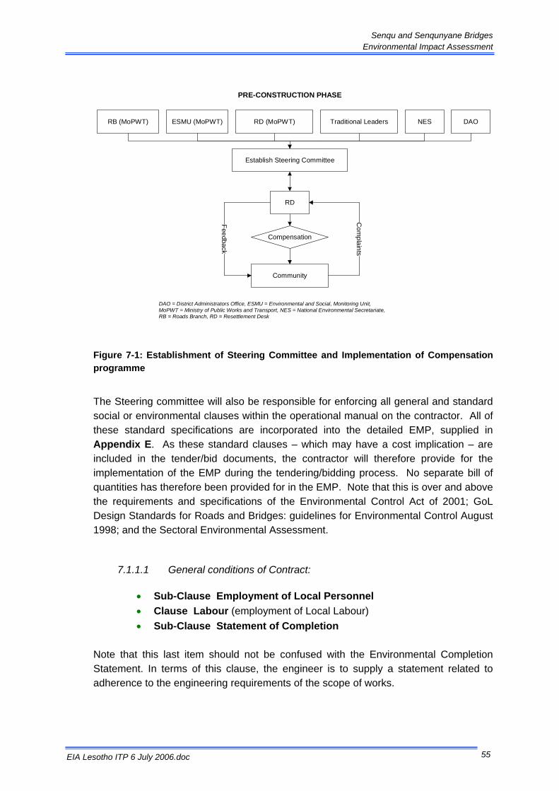
Senqu and Senqunyane Bridges Environmental Impact Assessment
RD (MoPWT) Traditional Leaders NES DAOESMU (MoPWT)RB (MoPWT)
Compensation
Community
Feedback
Com
plaintsC
omplaints
RD
DAO = District Administrators Office, ESMU = Environmental and Social, Monitoring Unit, MoPWT = Ministry of Public Works and Transport, NES = National Environmental Secretariate, RB = Roads Branch, RD = Resettlement Desk
Establish Steering Committee
PRE-CONSTRUCTION PHASE
Figure 7-1: Establishment of Steering Committee and Implementation of Compensation programme
The Steering committee will also be responsible for enforcing all general and standard social or environmental clauses within the operational manual on the contractor. All of these standard specifications are incorporated into the detailed EMP, supplied in Appendix E. As these standard clauses – which may have a cost implication – are included in the tender/bid documents, the contractor will therefore provide for the implementation of the EMP during the tendering/bidding process. No separate bill of quantities has therefore been provided for in the EMP. Note that this is over and above the requirements and specifications of the Environmental Control Act of 2001; GoL Design Standards for Roads and Bridges: guidelines for Environmental Control August 1998; and the Sectoral Environmental Assessment.
7.1.1.1 General conditions of Contract:
• Sub-Clause Employment of Local Personnel • Clause Labour (employment of Local Labour) • Sub-Clause Statement of Completion
Note that this last item should not be confused with the Environmental Completion Statement. In terms of this clause, the engineer is to supply a statement related to adherence to the engineering requirements of the scope of works.
EIA Lesotho ITP 6 July 2006.doc 55

Senqu and Senqunyane Bridges Environmental Impact Assessment
7.1.1.2 Standard Specifications for Road and Bridge Works for Road Authorities, 1998 Edition (as modified) series 1000:-
• Section B1500 and B2000 – Accommodation of traffic • B1515 Warning Signs • B2003 Accommodation of contractor’s traffic
• Section B1800 – Promotion of Awareness and Mitigation of HIV / AIDS,
Gender Mainstreaming • B1803 Liaison with communities and local authorities (dealing and
interaction with local community leaders and members) • B1804 Promotion of awareness and mitigation of HIV/ AIDS
(establishment of an awareness programme and training through the appointment of an independent service provider. The MoPWT generally prefer the use of CARE, which has an established awareness and monitoring programme currently operating in Lesotho)
• B1805 Gender Mainstreaming (contractor’s recognition of women’s rights and concerns during the construction period)
• Section B1900 Site Safety and Health Requirements
• B1902 Site Safety (Management of Construction traffic, Noise nuisance, Water abstraction and waste management)
• B1903 Contractors Construction camp (Storage of hazardous materials, effluent waste, and rehabilitation after construction).
• B1904 Quarry operations (Safety aspects and rehabilitation)
• Section B3100 Borrow Materials (all items)
• Section B3300 Mass Earthworks • B3306 Cut and Borrow (Temporary Stockpiling)
• Section B3400
• B3403 Construction (Temporary Stockpiling) • B3404 Protection and Maintenance (establishment of stormwater
control measures)
• Section 3300 Earthworks and pavement layers of gravel or crushed Stone General clauses relating timing and frequency of permitted blasting
7.1.2 Environmental Site agent
The environmental site agent (ESA) is the person responsible for the monitoring of the implementation of the environmental management plan. The ESA will also be
EIA Lesotho ITP 6 July 2006.doc 56

Senqu and Senqunyane Bridges Environmental Impact Assessment
responsible for liaison with and reporting to the environmental/social coordinators of MOPWT and NES. This person may be someone involved with the project acting on behalf of the Developer, but must however be a person with adequate environmental knowledge to understand and implement this management plan. The ESA may not be someone appointed by the contractor and should ideally report to the Developer/Steering Committee only. The ESA has the authority to stop works if in his opinion there is a serious threat to or impact on the environment caused directly by the construction operations. This authority is to be limited to emergency situations (see definitions) where consultation with the RE or Developer is not immediately possible. In all such work stoppage situations the ESA is to inform the RE and Developer of the reasons for the stoppage as soon as possible. Upon failure by the contractor or his employees to show adequate consideration to the environmental aspects of this contract, the ESA may recommend to the engineer to have the contractor's representative or any employee(s) removed from the site or work suspended until the matter is remedied. No extension of time will be considered in the case of such suspensions and all costs will be borne by the contractor.
7.1.3 Environmental and HIV/AIDS Awareness Training for Site Personnel
All contractor teams involved in construction work are to be briefed on their obligations towards environmental controls and methodologies in terms of this EMP as well as HIV/AIDS awareness training prior to commencing of works. The briefing will usually take the form of an on-site talk and demonstration by the ESA in conjunction representatives of an implementing agency such as CARE. Education / awareness programmes should be aimed at all levels of management and staff within the contractor team. Environmental awareness training – over and above the requirements to provided HIV/AIDS and health awareness training – must also be provided to the community.
7.1.4 Communication Procedures on Site
Each of the books described below must be available in duplicate, with copies for the RE and ESA or alternatively an agreement could be reached to use a single system. These books should be available to the authorities for inspection on request. Contractors meeting minutes must reflect environmental queries, agreed actions and dates of eventual compliance. These minutes form part of the official environmental record.
EIA Lesotho ITP 6 July 2006.doc 57

Senqu and Senqunyane Bridges Environmental Impact Assessment
7.1.4.1 Site Instruction Entries
The Site Instruction book entries will be used for the recording of general site instructions as they relate to the works on site. It will also be used for the issuing of stop work orders for the purposes of immediately halting any particular activities of the contractor in lieu of the environmental risk that they may pose.
7.1.4.2 ESA Diary Entries
The purpose of these entries will be to record the comments of the ESA as they relate to activities on the site.
7.1.4.3 Method Statements
Method statements from the Contractor will be required for specific sensitive actions on request of the authorities or ESA. A method statement forms the base line information on which sensitive area work takes place and is a “live document” in that modifications are negotiated between the Contractor and ESA / RE, as circumstances unfold. All method statements will form part of the EMP documentation and are subject to all terms and conditions contained within the EMP main document. Refer to the standard method statement sheet included as Appendix F. A method statement describes the scope of the intended work in a step-by-step description in order for the ESA and RE to understand the Contractors intentions. This will enable them to assist in devising any mitigation measures, which would minimise environmental impact during these tasks. For each instance wherein it is requested that the Contractor submit a method statement to the satisfaction of the ESA, the format should clearly indicate the following:
• What - a brief description of the work to be undertaken; • How - a detailed description of the process of work, methods and
materials; • Where - a description/sketch map of the locality of work (if applicable);
and • When - the sequencing of actions with due commencement dates and
completion date estimates. The Contractor must submit the method statement before any particular construction activity is due to start. Work may not commence until the method statement has been approved by the ESA.
EIA Lesotho ITP 6 July 2006.doc 58

Senqu and Senqunyane Bridges Environmental Impact Assessment
7.1.4.4 Environmental Completion Statement
An Environmental Completion Statement is a report by the ESA to the relevant authorities stating completion of the project and compliance with the EMP and conditions. This statement will be prepared after the final audit after the rehabilitation phase.
7.1.5 Record Keeping
All records related to the implementation of this management plan (e.g. site instruction book, ESA diary, method statements) must be kept together in an office where it is safe and can be retrieved easily. These records should be kept for a minimum of two years and should at any time be available for scrutiny by any relevant authorities. It is recommended that photographs are taken of the site prior to, during and immediately after construction as a visual reference. These photographs should be stored with other records related to this EMP.
7.2 Monitoring and Evaluation of the EMP implementation
As previously indicated, the RE will be responsible for the day to day implementation of the EMP, which will be overseen by the ESA who will be answerable to the Steering Committee. The ESA will also be responsible for implementation of the environmental monitoring programme outlined below, as well as reporting the findings to the Steering committee. The ESA will – in consultation with the steering committee – appoint an independent (external) auditor to evaluate the implementation in terms of the EMP and accepted objectives and practises. The auditor will compose audit reports, which will be presented at the steering committee meetings. In addition to the ESA addressing any transgressions and corrective measures taken, all site records maintained by the ESA will be evaluated. The effectiveness of the EMP implementation will therefore be evaluated on regular basis at the steering committee meetings. The steering committee will thereafter be required to amend the EMP if required, issue corrective actions to be implemented on site by the ESA or impose penalties for major transgressions. The proposed institutional arrangement is presented below in Figure 7-2.
7.2.1 Environmental Monitoring
This section details what needs to be monitored in terms of this EMP, detailing monitoring frequency and reporting requirements.
EIA Lesotho ITP 6 July 2006.doc 59

Senqu and Senqunyane Bridges Environmental Impact Assessment
7.2.1.1 Monitoring Plan for the Construction Phase
Regular meetings will be held between the Developer, the RE, and the ESA. The purposes of the meetings shall be:-
• To establish the suitability of the contractor’s methods and machinery in an effort to lower the risk involved for the environment.
• To discuss possible non-conformance to EMP guidelines or environmental legislation
• To assess the general state of the environment on site and discuss any environmental problems which may have materialised.
• To act as a forum for input into the construction phase by the MOPWT representative and external environmental auditor.
• To accommodate the local community in the decision-making process regarding social and environmental issues on site.
Monthly and non-conformance reports should be complied by the ESA for study by the external environmental auditor, RS-EU, RIA, NEMC and representatives of the WB. The monthly report should include:-
• Results of all testing performed as per this EMP in the specific month. This testing will be conducted either by an outside contractor or by the ESA with equipment acquired for the project by the contractor;
• A description of exceptional conditions on site whether they be meteorological, personnel related, machinery related, or otherwise stipulated;
• A description of any environmental accident or developments which could potentially develop into a non-conformance event by the contractor; and
• Minutes from the meetings. Non-conformance reports will describe, in detail, the cause, nature and effects of any environmental non-conformance by the contractor and could stand as evidence should legal action be required. A testing sheet with test results included for each infringement indicating the details of the event including position on site, date and time. If possible a photo should also be included in the report. This report will also suggest mitigation measures to correct the non-conformance (if necessary) and contemplate revisions to any of the strategies used in the construction phase, whether they pertain to monitoring or to construction methods used on site.
7.2.1.2 Testing Frequencies
Compliance monitoring and testing will be done as per this EMP to monitor EMP implementation and compliance and initiate corrective action if required. The ESA will
EIA Lesotho ITP 6 July 2006.doc 60

Senqu and Senqunyane Bridges Environmental Impact Assessment
develop sample sheets for regular monitoring and testing, as well as establish a proper filing system for record keeping purposes. Testing will be done as per relevant Lesotho standards, such as water quality standards. Where no such standards exist, international standards will apply. Testing frequencies for different aspects are listed below:-
• Potable water quality monitoring: every 2 weeks and more often if specific complaints are received from personnel or labourers;
• Discharge water quality monitoring: every 2 weeks and more often if specific complaints are received from personnel, labourers or the public;
• Air quality monitoring only if specific complaints are received; • Noise monitoring only when specific complaints are received; • Surface water quality: first samples are to be taken prior to any construction
activity to complete the baseline information and records kept, and again if discharge water quality drops to assess impact on the environment;
• Groundwater quality and pump tests of boreholes: first samples to be taken prior to any construction activity to complete the baseline information and records kept. These tests are to be repeated if discharge water quality drops to assess the impact on the environment.
• Erosion monitoring: weekly with details on position, extent and volume recorded accurately;
• Unstable Slope monitoring: weekly with details on position, extent and volume recorded accurately;
• Potholing of completed sections of road: weekly with details on position, extent and volume recorded accurately; and
• Conditions of culverts (records of culverts damaged or blocked): weekly with details on position, extent and volume recorded accurately.
Open communication channels must be maintained between the Contractor, the ESA and the local communities. This will be necessary for the negotiation of the construction camp site, negotiation of the operating times and blasting times. This will also provide for feedback from the communities regarding potential conflict areas and facilitation the resolution of any conflicts.
EIA Lesotho ITP 6 July 2006.doc 61

Senqu and Senqunyane Bridges Environmental Impact Assessment
Traditional Leaders NES DAORD (MoPWT)RB (MoPWT)
Steering Committee
ESMU (MoPWT)
ESAExternal Auditor
CONSTRUCTION
ESMU (MoPWT)
DAO = District Administrators Office, ESA = Environmental Site Agent, ESMU = Environmental and Social Monitoring Unit, MoPWT = Ministry of Public Works and Transport, NES = National Environmental Secretariate, RB = Roads Branch, RD = Resettlement Desk
CONSTRUCTION PHASE
Figure 7-2: Monitoring and Evaluation of the Effectiveness of the EMP
7.3 Environmental Mitigation and Management
A summary of predicted impacts is presented below in Table 7-1. Mitigation measures are proposed to reduce the significance is also presented. These mitigation measures have been incorporated into the detailed EMP, which is appended (Appendix F).
Table 7-1: Summary of impacts
DESCRIPTION OF ACTIVITY
ENVIRONMENTAL ASPECT
POTENTIAL IMPACT
MITIGATION
Placement of Construction camp
Surface and groundwater quality
Pollution of natural resources
• Storage of hazardous material in sealable containers
• Bunded fuel storage areas • Removal of domestic, construction or
effluent waste materials to registered facilities
Placement of Construction camp
Social structure Impact on social structure
• Siting of camp to be negotiated with communities
• Health, HIV/AIDS awareness training provided to imported labourers
• Labour to be drawn from local communities as far as possible
Clearing of vegetation Construction of pavement layers
Land use Loss of grazing • Compensation to be provided for loss of land tenure
Clearing of vegetation Construction of
Vegetation Loss of biodiversity
• Vegetation removal only within alignment • Where possible, plant rescue to occur
EIA Lesotho ITP 6 July 2006.doc 62

Senqu and Senqunyane Bridges Environmental Impact Assessment
pavement layers along alignment Clearing of vegetation Construction of pavement layers
Air quality
Increased emissions and dust generation
• Dust suppression to be conducted • Vegetation cover to be maintained as far
as possible • Vehicle emission controls to be
installed/maintained Clearing of vegetation Construction of pavement layers
Noise levels Increased noise generation
• Vehicles to be well maintained and fitted with correct muffler systems
• Normal working hours to be followed (07:00 to 19:00)
Clearing of vegetation Construction of pavement layers
Soil erosion Increased susceptibility to erosion
• Erosion control (temporary or permanent) to be installed prior to vegetation stripping
Clearing of vegetation Construction of pavement layers
Socio-economic Loss of income Job creation Increased STI’s due to influx of migrant workers
• Compensation to be provided for loss of land tenure
• Local labour to be utilised • HIV/AID’s and general health awareness
training to be provided • Environmental awareness training to be
provided Placement of pillars Placement of slabs
Aquatic/bank vegetation
Loss of biodiversity
• Vegetation to be cleared in alignment only
• If possible, plant rescue to be conducted along alignment
Placement of pillars Placement of slabs
Surface water flow Alteration of surface water flow patterns
• Placement of pillars to occur during low flow period (if possible)
• Surface are of pillars to be minimised • Pillar shape to facilitate flow around pillar
and prevent build-up of material Placement of pillars Placement of slabs
Water quality Increased sedimentation due to erosion
• Pillar shape to facilitate flow around pillar and prevent build up of material
EIA Lesotho ITP 6 July 2006.doc 63

Senqu and Senqunyane Bridges Environmental Impact Assessment
8 CONCLUSIONS
A comprehensive field survey and I&AP consultative process was conducted in order to identify affected stakeholders along the route alignment. As a result of this, key environmental, social and economic concerns were raised by various stakeholders, which include loss of livelihoods, security concerns and health and safety issues. These concerns and issues were then addressed through a detailed impact assessment process. Based on the outcomes of the impact assessment, it was established that the project would have significant positive impact on the social environment in the long term, with a low to moderate impact on the biophysical environment and a moderate to high impact on the hydrological environment in the short to medium term. The following specific conclusions can be drawn:-
1) The construction of the two bridges and connecting road will greatly improve access to the Ha Nkau area after construction. This translates to improved access to education, healthcare and commercial facilities.
2) The proposed infrastructure project will result in the creation of jobs
during the construction phase. The significance of the impact, although positive, can be increased through the use of local labour from surrounding communities. Existing governmental recruitment procedures must be followed when employing local labour.
3) The influx of labourers can have a negative impact on local communities
through increased transmission of HIV/AID’s or other STD’s in previously inaccessible areas. An HIV/AID’s and general health awareness training programme must be established to educate labourers and community members.
4) The construction of the access roads and bridges will impact negatively
on land use, in particular land currently under cultivation in the Ha Nkau and Seforong regions. In addition to this, the potential exists for the loss of communal grazing land and sterilisation of land for future cultivation/other use. Compensation, in terms of the RAP, will be required for loss of land tenure and assets.
5) Dust and emission generation will be problematic during the
construction phase, particularly where the road passes in close proximity to residences or places of social/cultural interest. This may have environmental as well as health implications. Dust suppression and maintenance will be required during the construction and operational phases to reduce dust entrainment.
6) The construction of the Senqu and Senqunyane Bridges will have a
moderate to high impact on the hydrological environment, particularly
EIA Lesotho ITP 6 July 2006.doc 64

Senqu and Senqunyane Bridges Environmental Impact Assessment
during the construction phase. These may include changes in hydrological functioning in the river channel, sedimentation occurring around the pillars, and increased sedimentation related to erosion. The construction and design layout of the bridges must facilitate the existing flow patterns in order to minimise the impact on hydrological regimes after construction.
7) Clearing of vegetation will have a moderate impact on biodiversity, as
well as increased susceptibility to erosion. This may have an additional (indirect) implication with regard to loss of grazing on communal grazing area. This can be mitigated through the rehabilitation of degraded area to reinstate grazing potential, as well the construction of erosion control mechanisms to reduce soil loss.
EIA Lesotho ITP 6 July 2006.doc 65
Senqu and Senqunyane Bridges Environmental Impact Assessment
9 RECOMMENDATIONS
It is critical that the project EMP described above is applied to mitigate significant impacts which may arise during the construction phase. The following general recommendations have been highlighted:- • Additional consultations with the directly affected persons must be conducted
once the alignment has been finalised, in order to verify and effect the compensation payments. This will include formal community meetings and individual consultations.
• Public Consultation and feedback must continue through the Construction phase, to facilitate good relations with the affected community members along the alignments. Existing community structures should be utilised to facilitate the process.
• Suitable compensation must be provided to identified affected land owners (Table 3-1) in accordance with strategies identified in the Resettlement and Compensation Policy Framework (Consult 4, September 2003) and Resettlement Plan.
• A steering committee, comprising representatives from the MoPWT, RIA, RS-EU, NEMC Local Headman and the contractor must be established to monitor the implementation of the EMP.
• Social and environmental mitigation management clauses, reflecting the implementation of the EMP must be incorporated into the tender and operational manuals supplied to the contractor/s to ensure that the measures are applied on site.
• An Environmental Site Agent must be appointed to oversee the day to day implementation of the EMP during the construction phase. The ESA will report directly to the MoPWT and provide monthly updates on the implementation of the EMP to the Steering Committee to be established.
• Local labour must be used as far as possible during the construction phase and existing Governmental recruitment procedures must be followed when appointing local labour.
• The ESA must supply environmental awareness training to labourers, as well as arranging HIV/AID’s and general health awareness prior to construction. Labourers drawn from local communities must be educated and trained to provide much needed skills which they can utilise on other projects.
• The specific mitigation of negative impacts as described in the impact evaluation tables and as elaborated by the Environmental Management Plan, must be implemented by the contractor. Environmental and social clauses must be incorporated into the tender document and operational guideline for the contractor.
• All management and mitigation measures must be instituted at the construction camp, to monitor and mitigate all potential impacts associated with such camps.
• Effective storm water management systems and structures must be put in place to ensure hydrological functioning.
EIA Lesotho ITP 6 July 2006.doc 66

Senqu and Senqunyane Bridges Environmental Impact Assessment
• Erosion control measures must be implemented throughout the project area where required and rehabilitation measures instituted.
• Traffic calming measures should be introduced along the alignments to reduce traffic speeds and associated risk to local roads users such as pedestrians or livestock.
• Rehabilitation should be done in accordance with specifications on completion of the works
• Additional allowance must be made in the contract for additional compensation and repair works that may result from construction activities.
EIA Lesotho ITP 6 July 2006.doc 67

Senqu and Senqunyane Bridges Environmental Impact Assessment
10 REFERENCES
Consult 4 (September 2003): Resettlement Policy Framework Study – Compensation and Resettlement Policy Framework for the Transport Sector. Study prepared for the Ministry of Public Works and Transport, Lesotho. Consult 4 (October 2005): Draft Resettlement Action Plan for the Semonkong –Sekake Road. Study prepared for the Ministry of Public Works and Transport, Lesotho.
EIA Lesotho ITP 6 July 2006.doc 68


APPENDIX A: TERMS OF REFERENCE TO AFRICON BY THE CLIENT

APPENDIX B: VEGETATION SURVEY CONDUCTED BY LERATO KOSE AND MOLETSI POLAKI IN JANUARY 2006

APPENDIX C: MINUTES OF PUBLIC MEETINGS AT SEFORONG AND HA NKAU

APPENDIX D: RESETTLEMENT ACTION PLAN

APPENDIX E: DETAILED ENVIRONMENTAL MANAGEMENT PLAN

Senqu and Senqunyane Bridge and Interconnecting road: Environmental Management Plan
A ENVIRONMENTAL MANAGEMENT PLAN
The EMP presented herein has been formulated to realise the mitigation measures indicated in section 7.3 above. The goal of the mitigation and management measures indicated is to reduce the environmental risk associated with the road construction project; ensure compliance with acceptable environmental objectives and legislation; and align the environmental management with the standard environmental and social clauses prescribed in the Contractor’s contract and Operational Manual. As previously indicated, clauses binding the contractor the requirements of the EMP must be included in the contract, thereby legally binding them to the implementation of the approved EMP.
A.1 Fencing
• Fencing of the campsite and construction area (if applicable) shall be suitably secured to prohibit access by live stock and local fauna.
• No unauthorised pedestrian or vehicular access shall be allowed into fenced off-limits areas.
• Fencing shall be kept neat at all times. The contractor shall be responsible for the maintenance of all fences.
• If temporary fencing is removed temporarily for the execution of work, the contractor shall reinstate it as soon as practicable.
• Breaches in the fencing must be repaired immediately. The purpose of the fenced areas is to control construction and personnel activity within the designated areas, and limit unauthorised access.
A.2 Clearing and Grubbing
• Contractor shall at all times carefully consider what machinery is appropriate to the task while minimising the extent of environmental damage.
• Topsoil shall be cleared of woody vegetation and specifically exotic vegetation before ripping and removing.
• The topsoil is regarded as the top 300 mm of the soil profile irrespective of the fertility appearance.
• Topsoil is to be stripped when it is in as dry a condition as possible in order to prevent compaction.
• The topsoil, including the existing grass cover is to be shallowly ripped (only the depth of the topsoil) before removal. This is to ensure that organic plant material, and the natural seed base is included in the stripping process.
EIA Lesotho ITP 6 July 2006.doc 1

Senqu and Senqunyane Bridge and Interconnecting road: Environmental Management Plan
• Soil stockpiles shall not be higher than 2.5 m or stored for a period longer than one year. The slopes of soil stockpiles shall not be steeper than 1 vertical to 2.5 horizontal.
• No vehicles shall be allowed access onto the stockpiles after they have been placed.
• Stockpiles shall not be allowed to become contaminated with oil, diesel, petrol, garbage or any other material, which may inhibit the later growth of vegetation.
• The contractor shall apply soil conservation measures to the stockpiles to prevent erosion. This can include the use of erosion control fabric or grass seeding.
• If at any stage of the clearing operations archaeological artefacts are unearthed or identified the relevant organisations are to be contacted immediately to conduct a thorough scientific investigation of the finds.
• The works shall be cleared of alien vegetation as identified by the ESA. An effort must be made to remove the entire root system where after the plant shall be left to dry out on a hard surface that will not facilitate the germination of seed.
A.3 Site Buildings / Construction Camp
• The planning and design for the Construction Camp must ensure that there is a minimum impact on the environment. Where possible existing infrastructure and disturbed areas must be used.
• No construction camps will be allowed in sensitive areas such as wetlands. • All site buildings to be of a container or prefabricated type. With the
decommissioning of the structures all compacted platforms and slab foundations must be ripped and removed, unless otherwise negotiated with the local communities.
• All buildings will be soundly built and will not pose a danger to personnel. • No fires may be allowed outside the construction area / construction camp and
adequate fire fighting equipment according to the fire hazard during the construction period must be available on site in good working order (at least one all purpose 12.5 kg extinguisher).
• Welding, gas cutting or cutting of metal will only be permitted inside the working areas.
• The Contractor shall pay the costs incurred to organisations called to put out any fires started by him. The Contractor shall also pay any costs incurred to reinstate burnt areas as deemed necessary by the ESA.
EIA Lesotho ITP 6 July 2006.doc 2

Senqu and Senqunyane Bridge and Interconnecting road: Environmental Management Plan
A.4 Initial Earthworks and Platforms
• The construction platform for the contractor’s camp, as well as the platform for the materials storage area must be appropriately planned.
• The Contractor shall take appropriate and active measures to prevent erosion resulting from his own works, operations and activities as well as stormwater control measures to the satisfaction of the ESA / RE. Restoration costs will be for the contractor's account, should these measures not be reasonably implemented. Aspects normally covered in construction contracts in terms of “protection of works” are standard and are not to be billed or confused with any details covered under environmental requirements.
• During construction the Contractor shall protect areas susceptible to erosion by installing all the necessary temporary and permanent drainage works as soon as possible. All such measures must be discussed with and approved by the ESA / Engineer.
• Measures can include cut off trenches, straw stabilising, brush packing etc.
A.5 Explosives Storage
The storage of explosives will be permitted on the following conditions:
• All storage and handling of explosives to be done in accordance with the relevant legal requirements and industry guidelines such as the South African Explosives Act of 1956, or any regulations since published in terms of Section 75 of the Lesotho Environment Act of 2001.
• An explosives and detonator magazine has to be established on site for the storage of explosives.
• The contractor shall submit a proposal as to the design and siting of such magazine to the RE before approval and representation is to be made to the relevant authorising and permitting authority.
• The contractor will be responsible for the fencing and safeguarding of such magazine.
• Only suitably qualified and experienced technicians will be allowed to handle explosives on site.
A.6 Vehicle Parking Area
• All vehicles and plant will be allocated a dedicated parking area in the camp site.
• No storage of plant and vehicles will be allowed outside of the designated area.
EIA Lesotho ITP 6 July 2006.doc 3
Senqu and Senqunyane Bridge and Interconnecting road: Environmental Management Plan
A.7 Service Area / Wash Bay
• All vehicle and plant shall be maintained to ensure that there are no oil or fuel leakages.
• The contractor will provide a dished concrete floor slab to prevent infiltration of petroleum products.
• Drainage from the service area will be channelled into a sump or oil-skimming tank, where it shall be treated to remove oil and/or fuel.
• Drainage from the wash bay platform will firstly be channelled into the skimming tank before being released by drain to the sedimentation pond.
• Soil contaminated by oil, fuel or chemicals shall be removed and disposed of at a permitted landfill site.
• The contractor shall educate workers on the appropriate methods for workshop maintenance and fuel points to prevent fuel and oil being washed out of containment areas.
• Toxins and oil must be recovered from the system at least once a week, and if necessitated more regularly.
• Toxins and oil recovered must be stored in sealed drums in a bunded area and taken to Maseru where it can be recycled by any of the petroleum companies.
• Effluent discharge from the settling ponds shall not exceed the relevant effluent quality standards, such as the South African Water Quality Guidelines Vol 4 for Agricultural use: Irrigation, published by the Department of Water Affairs and Forestry (Second edition, 1996), or any standards since published in terms of Section 36(1)(b) of the Lesotho Environment Act of 2001, as specified under Section 36(1)(b)(iii) – water for agricultural purposes.
• All spillage of oil onto concrete surfaces shall be controlled by the use of an approved absorbent material such as Econosorb or Drizit.
• The servicing of plant and vehicles will not be allowed elsewhere on site.
A.8 Separation Tanks
• The contractor shall provide grease and oil separation tanks (if required) at all areas where oil spillage or collection will occur, i.e. workshops, oil storage, vehicle wash areas and fuel points.
• The contractor shall provide a method for oil recovery. Recovered oil shall be collected in drums for recycling or disposed of at a permitted hazardous waste site.
• The contractor will test effluent discharged from the oil skimming tanks for conformance with relevant effluent standards if requested to do so by the ESA when pollution is suspected.
EIA Lesotho ITP 6 July 2006.doc 4

Senqu and Senqunyane Bridge and Interconnecting road: Environmental Management Plan
A.9 Aggregate Storage
• Materials will be stored inside the camp area as far as possible. • Fine aggregate shall be stored on a compacted sub-base platform. • The contractor will ensure (and implement steps if required, e.g. bund walls)
that no fine aggregate is washed from the storage area onto the rest of the site. • Coarse aggregate will be stored as a minimum on a surface of compacted inert
sub-base material. • An approved borrow pit must be used for construction materials. • Aggregate used shall be stored as compactly as possible so as to minimise the
possibility of it spreading across a greater area than necessary and to prevent it from being washed away.
A.10 Cement Silos / Storage
• Cement shall be delivered in sound and properly secured sacks or in approved bulk containers.
• Cement products in sacks shall be stored in an enclosed storage area. The storage facility and surrounding area shall be swept and cleaned regularly as required to ensure that cement products do not enter the surrounding environment.
• Bulk delivered cement products will be stored in approved cement silos. • Air filters are to be monitored and cleaned and replaced on a regular basis.
A.11 Fuel Storage Areas
• The contractor shall provide and maintain bund walls around his fuel storage areas within the site with a sump. Such walls shall be of sufficient height to contain a minimum of 110 % of the contents of his fuel storage facilities.
• This shall apply to storage above the ground. No underground fuel storage will be allowed.
• All drainage from fuel storage areas shall be treated to remove oil and fuel.
A.12 Dust Control
• The Contractor is to take appropriate measures to minimise the generation of dust as a result of construction works, to the satisfaction of the ESA.
• Dust control by means of water-spraying would be sufficient on these sites.
EIA Lesotho ITP 6 July 2006.doc 5

Senqu and Senqunyane Bridge and Interconnecting road: Environmental Management Plan
A.13 Batching Plant
• Concrete shall only be mixed in areas which have been specifically demarcated for this purpose.
• All concrete spilt shall be promptly removed by the contractor to an approved disposal site.
• After mixing is complete all waste shall be removed from the batching area and disposed of at an approved disposal site.
• No storm water is permitted to flow through the batching site. • All residue water from concrete batching plants or the surface run-off from them
will be led to specially constructed collection ponds. • Batching plant is to be enclosed by a bund wall with dedicated divisions and
compartments for the various types of materials. • Air filters are to be monitored and cleaned and replaced on a regular basis. • All effluent from mixer washing, and run-off from batching areas and other work
areas shall be contained in suitable sedimentation ponds. • Sedimentation ponds shall be allowed to dry out on a regular basis to allow for
solid material to be removed. This material must be disposed of in a suitable manner, depending on the nature of the material and to the discretion of the ESA.
• Care must be taken to ensure that no water from the construction site enters the agricultural land adjacent to the site, or the natural watercourses.
A.14 Access Roads and Accommodation of Traffic
• Existing access roads will be used as far as possible. • Topsoil shall be removed as described under 'Clearing and Grubbing' prior to
the construction of the road. • All new temporary roads shall be approved by the ESA. • All temporary roads shall be decommissioned by the contractor and
rehabilitated using the stockpiled topsoil. • During construction the contractor shall protect all areas susceptible to erosion
by installing all necessary temporary and permanent drainage works as soon as possible.
• The accommodation of traffic is an important aspect on these roads. Where required, temporary works to facilitate the accommodation of traffic during bridge construction, should be completed first as road closures will not be permitted.
A.15 Sanitation
• Adequate chemical latrines shall be provided for all staff.
EIA Lesotho ITP 6 July 2006.doc 6

Senqu and Senqunyane Bridge and Interconnecting road: Environmental Management Plan
• They shall be serviced once a week to prevent overflowing. • All latrines provided by the contractor shall be efficient, sanitary and non-
offensive. • All fees payable to any local authority for removal of night soil (if applicable)
shall be paid by the contractor. • A minimum of one toilet shall be provided per 20 persons at each working area
such as the construction camp and bridge.
A.16 Temporary Storage of Waste
A.17 Construction Waste
• Temporary storage of construction waste will be limited on the site, and within the designated areas.
• The contractor will be responsible to remove and transport all waste material off site to an approved site.
• Spoil material will as far as possible be used in the shaping of the area during rehabilitation, or alternatively removed to an identified borrow pit.
Domestic Waste • The contractor shall dispose of all refuse generated by his staff and sub-
contractors on a weekly basis at an approved disposal site. • The contractor shall on a daily basis do site clean-ups (chicken runs) of litter
other than construction spoil, and dispose of it in designated refuse bins provided on site.
A.18 Borrow Pits
• Existing borrow pits will be used as far as possible. • No areas where water will pond will be allowed at any borrow pit after use due
to the risk of children drowning. • No steep slopes will be allowed at borrow pits. • All borrow pits to be rehabilitated after use, including battering and shaping,
topsoiling and revegetation as described elsewhere in this EMP.
A.19 Blasting
• All blasting shall be conducted in terms of the relevant Lesotho and international regulations.
• Blasting shall be limited to a specific period of the day so as to minimise disturbance. This time schedule is to be determined and approved with the RE. It is recommended that blasting take place between 12:00 noon and 15:00.
EIA Lesotho ITP 6 July 2006.doc 7

Senqu and Senqunyane Bridge and Interconnecting road: Environmental Management Plan
• A blasting time schedule shall be distributed to all surrounding villages indicating the time and date for blasting activities.
• It may be required to announce the blasting time period prior and upon completion by siren.
• Where blasting is required every precaution shall be exercised to protect the works and persons, animals and properties in the vicinity of the site.
• The contractor shall complete pre- and post-blast surveys in the vicinity of the site.
• The contractor will be responsible for all injury and damage occasioned by any blasting operations and shall compensate for such injury or damage repair.
• All workmen engaged on blasting at the site shall be experienced in this work and shall be familiar with the relevant regulations, copies of which shall be kept on site by the contractor.
• The contractor shall take measures to limit flyrock. This may be achieved by matching the charge to the rock type, by using milli-second delay detonators or by using rubber blasting mats
• No blasting shall be carried out until permission has been obtained in writing from the RE; who may prohibit the use of explosives near pipelines, cables, roads and villages and concrete already placed and who may restrict the size of charges.
• At all times blasting shall be carried out that ground vibration, air blast and scatter are kept within such limits as to avoid damage to adjacent structures or concrete already placed at the works. Peak particle velocity may be restricted to 50 mm/sec or less at the discretion of the RE.
• Where there is a possibility of shattering rock, the RE may order the contractor to cease blasting and continue to excavate the rock without the use of explosives, by barring, breaking, wedging, line drilling or other approved methods.
A.20 Screening
• The process of separating rock material into acceptable grades for backfilling and layerworks material will result in noise and dust.
• The contractor shall suppress dust caused by the screening process. • The screening process shall be positioned so as not to cause any disturbance
to surrounding villages.
A.21 Stock Piling and Spoil Material
• All suitable materials excavated shall be used in the construction of the works. • All unsuitable and surplus spoil rock shall be removed from the site to a
dumping site or sites, to be negotiated by the contractor and approved by the
EIA Lesotho ITP 6 July 2006.doc 8

Senqu and Senqunyane Bridge and Interconnecting road: Environmental Management Plan
RE where it shall be dumped, spread and levelled, all to the satisfaction of the RE and ESA.
• No dumpsite shall be used without the prior written approval of the RE and the owner of the property.
• No spoil material shall be stockpiled in violation of any legal requirement or to obstruct any watercourse or drainage channel.
A.22 Concrete Construction
• All cement and concrete batching shall take place within the designated batching plant area.
• Concrete and cement products shall be transported to the construction site with due care. Any spills will be removed and stockpiled on the construction waste area to be removed from site to an approved landfill site.
• Temporary storage of construction spoil will be limited on the site, and within the designated areas.
• The contractor will be responsible to remove and transport all concrete waste material off site to an approved site.
A.23 Shaping
• The soil surface shall be contoured, and the edges of all cut and fill areas rounded to fit into the natural landscape.
• Topsoil shall be spread in keeping with the natural topographical form of the site and immediate surroundings.
A.24 Topsoil Placement
• Topsoil shall be placed to a minimum depth of 150 mm over all areas that have been disturbed by the construction activity.
• Topsoil placement shall follow as soon as construction in an area has closed. • All compacted areas shall be ripped parallel to the contours to a minimum depth
of 300 mm. • All areas onto which topsoil is to be spread shall be graded to the approximate
original landform and shall be ripped prior to placement. • Topsoil shall be placed in the same soil zone from which it had been stripped.
If there is insufficient topsoil available for a particular soil zone, additional topsoil may be brought from other soil zones at the approval of the ESA.
• Where topsoil that has been stripped by the contractor is insufficient to provide the minimum depth, the contractor shall obtain suitable substitute material from other approved sources.
EIA Lesotho ITP 6 July 2006.doc 9
Senqu and Senqunyane Bridge and Interconnecting road: Environmental Management Plan
• No vehicles shall be permitted access onto the topsoil after it has been placed.
A.25 Revegetation
• Flat and gently sloping areas shall be ripped in lines 300 mm centre to centre and to a depth of at least 300 mm parallel to the contours prior to revegetation.
• Revegetation of disturbed and work areas shall be done with an indigenous grass mix; similar to what is found in the vicinity of the site.
A.26 Storm water Management
• During construction the contractor shall protect all areas susceptible to erosion by installing all necessary temporary and permanent drainage works as soon as possible.
• Any erosion channels developing during the construction period or during the operational and maintenance period shall be backfilled and consolidated immediately and the area restored to the proper condition. All erosion damage shall be repaired as soon as possible. Displaced topsoil shall be replaced.
A.27 Traffic and Plant on Site
• Adequate and appropriate traffic warning signage will be placed along the route to be used by the construction vehicles from the camp and the borrow pit to the site.
• Adequate and appropriate traffic warning signage will be placed along the route to warn public of construction work and heavy vehicle traffic.
• Transporters of fine materials must ensure that their operation does not pose a nuisance through the spillage of material or the creation of dust. The contractor shall remedy, at his own expense, dust generation and spillage where it occurs to an unacceptable level along the transport routes. It is recommended that the load haul of all transport vehicles be covered with tarpaulins.
• Deliveries shall be scheduled for off-peak hour traffic time schedules. • All trucks and vehicles removing spoil from the site shall have the load areas
covered by a tarpaulin to prevent rocks and spoil from falling onto the road surfaces, or causing a nuisance to persons in the vicinity.
A.28 Personnel
• Working hours will be agreed upon with the affected communities prior to construction.
EIA Lesotho ITP 6 July 2006.doc 10

Senqu and Senqunyane Bridge and Interconnecting road: Environmental Management Plan
• Warning signs must be placed on and around the site as per the occupational health and safety requirements.
• Cooking facilities shall be provided for the construction staff within the confines of the construction camp. No trees may be removed for the making of fires and no collection of wood will be allowed.
• If possible, local kitchens/food services to be utilised for the provision of food to labourers.
• No fires shall be permitted, unless a specifically designated area has been identified and set aside by the RE for that purpose.
• Where there is a particular fire hazard at any point in the construction works the contractor shall ensure that his employees are properly trained in the use of the appropriate fire fighting equipment and that such equipment is on hand at all times.
• The contractor shall refrain from harming or clearing trees, timber and shrubs to any extent other than that indicated by the RE for the execution of the contract.
• The contractor shall take all measures necessary to prevent his staff from hunting, capturing or killing animals and birds in the vicinity of the construction activities.
• The contractor shall take all necessary precautions against trespassing on adjoining properties and shall take care that all livestock, game or crops are not interfered with.
• The contractor shall comply with all safety regulations regarding the electricity supply and he shall take every precaution to ensure the safety of all the people on site.
• The contractor shall ensure that as far as practical, suitable arrangements are made on the site for the maintenance of health, the prevention and overcoming of outbreaks of disease. Adequate first aid and emergency transport services should be available.
• The contractor shall be responsible for his own security arrangements and shall comply with any security instructions, which the RE may issue from time to time.
• The contractor shall ensure that suitable safety regulations and precautions are established and brought to the attention of the personnel. Approved safety helmets and other protective clothing shall be worn where deemed necessary by the RE.
• The contractor shall, at his own cost provide for a constant supply of potable water for human consumption to the site offices and other domestic use on site. The contractor shall allow for chemical testing of water samples on a monthly basis, or more frequently if pollution is suspected by the ESA.
• The contractor is responsible for the behaviour and discipline of all personnel while they are present on the site and shall exercise strict supervision over them at all times.
EIA Lesotho ITP 6 July 2006.doc 11

Senqu and Senqunyane Bridge and Interconnecting road: Environmental Management Plan
A.29 Personnel Education
• The contractor shall ensure that his personnel are educated and informed as to the requirements of the EMP.
• The contractor shall ensure that his personnel have a clear understanding of the Health and Occupational Safety aspects of the contract works.
• The contractor shall ensure that his staff complies with the EMP requirements for best practice as described by this document.
A.30 Works affecting planted fields
• Where the road follows an alignment next to a planted field, due care shall be taken not to disturb the state of the field.
• No vehicular traffic will be allowed in any agricultural field. • Where required, slopes up to agricultural fields need to be protected to ensure
slope stability at all times. • Compensation for loss of cultivated fields will be as per the Resettlement Plan
proposed by Consult 4 (October 2005) will be carried out prior to the commencement of construction. A list of properties to be impacted on the proposed road alignment is indicated in Table 3-1 above.
A.31 Crossing of the Rivers
• The contractor is requested to notify the Department of Water Affairs in writing of the proposed commencement of construction and provide the department with a construction programme, prior to any work commencing in proximity of the river or riverbank.
• Extreme caution shall be taken during construction owing to the steep, eroded nature of the river embankment. The ESA shall assess any preventable damage caused by the contractor and prescribe rehabilitation measures to be completed at the contractor's expense.
• No construction materials or pollutants, such as cement, shall be allowed to fall/ flow into the riverbed.
• No washing of clothes or vehicles will be allowed in the rivers. • A laundry facility will be provided in the construction camp. The effluent from
this facility (grey water) will drain into a French drain system to be constructed for this purpose.
• Only environmentally friendly bio-degradable detergents will be allowed in the construction camp.
• Any activity which brings about the run-off of sediments into any watercourse shall be forbidden
• Any activity which adversely affects aquatic fauna and flora shall be forbidden
EIA Lesotho ITP 6 July 2006.doc 12
Senqu and Senqunyane Bridge and Interconnecting road: Environmental Management Plan
• The flow of the river may not be affected during construction and under no circumstances will the stream be blocked.
A.32 Fauna and Flora
• Natural vegetation shall be kept in as undisturbed a state as possible. Special attention shall be paid to preserve trees and plant communities such as wetlands, sponges, forest of any sort and riparian vegetation.
• Indigenous plants or wild animals (including reptiles, amphibians or birds etc.) may not be damaged or harmed. Vegetation removals as part of the development requirements are excluded.
• All incidents of harm to any animal or natural vegetation (apart from the agreed areas) must be reported to the ESA.
A.33 Embankments
• No activity shall be allowed which shall, in any way, create unnecessary disturbance of any river embankment due to the extreme sensitivity of these zones.
• Care must be taken to ensure that machinery used does not erode the embankments further. The embankments are severely eroded in places and the contractor must ensure that no further degradation occurs.
A.34 Site Clean Up and Rehabilitation
• The Contractor must ensure that all structures, equipment, materials and facilities used or created on site for or during construction activities are removed once the project has been completed.
• The construction site shall be cleared, and cleaned and rehabilitated to the satisfaction of the ESA, prior to revegetation.
A.35 Monitoring
The Roads Implementation Agency (RIA) and Ministry of Works Environmental Unit (RS-EU), in conjunction with the National Environmental Management Council (NEMC) will be invited to attend environmental steering committee meetings, and will oversee and approve the monitoring done by the ESA.
A.36 Monitoring Plan
EIA Lesotho ITP 6 July 2006.doc 13

Senqu and Senqunyane Bridge and Interconnecting road: Environmental Management Plan
APPENDIX F: EXAMPLE OF A METHOD STATEMENT
EIA Lesotho ITP 6 July 2006.doc


