ENVIRONMENT AND SOCIAL IMPACT ASSESSMENT Impact... · valley, in Othaya division, Nyeri District,...
56
1 PROPOSED GURA SMALL HYDROPOWER PROJECT E E N N V V I I R R O O N N M M E E N N T T A A N N D D S S O O C C I I A A L L I I M M P P A A C C T T A A S S S S E E S S S S M M E E N N T T FINAL REPORT March 2008 R.J. Mwendandu Que Energy Ltd P. O. Box 47054 Nairobi 00100
Transcript of ENVIRONMENT AND SOCIAL IMPACT ASSESSMENT Impact... · valley, in Othaya division, Nyeri District,...

1
PROPOSED GURA SMALL HYDROPOWER PROJECT
EENNVVIIRROONNMMEENNTT AANNDD SSOOCCIIAALL
IIMMPPAACCTT AASSSSEESSSSMMEENNTT
FINAL REPORT
March 2008
R.J. Mwendandu
Que Energy Ltd
P. O. Box 47054
Nairobi 00100

Gura SHP Project - Environmental and Social Impact Assessment
IED – Innovation Energie Développement 2
Table of Contents
EXECUTIVE SUMMARY ......................................................................................... 5
1.0 PROJECT DESCRIPTION ............................................................................ 8
1.1 General Project Background ................................................................................................... 8
1.2 Project Location ....................................................................................................................... 8
1.3 A Comparative Advantage of the Project .............................................................................. 8
1.4 Key Project Components ......................................................................................................... 9
1.5 The ESIA Team ........................................................................................................................ 8
2.0 PROJECT DESIGN......................................................................................... 9
2.1 Intake ........................................................................................................................................ 9
2.2 Channel ................................................................................................................................... 10
2.3 Forebay ................................................................................................................................... 11
2.4 Penstock .................................................................................................................................. 12
2.5 Power House ........................................................................................................................... 12
3.0 ENVIRONMENTAL BASELINE INFORMATION ................................. 13
3.1 General status ......................................................................................................................... 13
3.2 Topographic trends ................................................................................................................ 14
3.3 Geology, drainage, and soils .................................................................................................. 14
3.4 Land use patterns ................................................................................................................... 15
3.5 Forest, Products and Wood Energy ...................................................................................... 15
4.0 SOCIAL AND ECONOMICS INFORMATION ........................................ 19
4.1 General social considerations ................................................................................................ 19
4.2 Existing socio-economic situation in the project area. ........................................................ 19
4.3 Engagement mechanisms for integrating the community in the project. .......................... 20
5.0 CONSULTATIVE PUBLIC PARTICIPATION ........................................ 21
5.1 Introduction ............................................................................................................................ 21
5.2 Summary of issues arising from the consultations .............................................................. 21 5.2.1 Compensation ...................................................................................................................... 21
Gura SHP Project - Environmental and Social Impact Assessment
IED – Innovation Energie Développement 3
5.2.2 Safety ................................................................................................................................... 22 5.2.3 Employment Opportunities ................................................................................................. 22 5.2.4 Conclusion ........................................................................................................................... 22
6.0 LEGISLATIVE AND REGULATORY CONSIDERATIONS ................. 23
6.1 The Environmental Management and Coordination Act, 1999 ......................................... 23
6.2 Water Act 2002 ....................................................................................................................... 24
6.3 Forest Act 2005 ....................................................................................................................... 25
6.4 Health and safety regulations; Public Health Act (Cap 242) .............................................. 26
7.0 ENVIRONMENTAL MANAGEMENT PLAN .......................................... 28
7.1 Overview ................................................................................................................................. 28
7.2 General impacts ...................................................................................................................... 28
7.3 ESMP matrix .......................................................................................................................... 29
8.0 CONCLUSION .............................................................................................. 33
APPENDIX 1: PICTURES OF GURA HYDROPOWER SITE ........................... 35
APPENDIX 2: PICTURES OF GURA HYDROPOWER SITE ........................... 39
APPENDIX 3: NYERI ADMINISTRATIVE BOUNDARIES .............................. 42
APPENDIX 4: ATTENDANCE LIST AT CONSULTATIVE MEETING ......... 43
APPENDIX 5: SOCIAL SURVEY TEMPLATE ................................................... 47
APPENDIX 6: WATER ABSTRACTION REQUEST .......................................... 49
APPENDIX 7: NYERI DISTRICT FACT SHEET ................................................ 50

Gura SHP Project - Environmental and Social Impact Assessment
IED – Innovation Energie Développement 4
List of Abbreviations
ASAL Arid and Semi Arid Lands
EATTA East African Tea Trade Association
ERC Electricity Regulatory Commission
ESIA / EIA Environmental and Social Impact Assessment
ESMP Environmental and Social Management Plan
FUM Factory Unit Manager
GEF Global Environment Facility
KTDA Kenya Tea Development Agency
SHP - MHP Small - Mini Hydro Power
MoE Ministry of Energy
NEMA National Environmental Management Authority
WRMA Water Resources Management Authority
List of Tables
Table 1: Description of the main vegetation types
Table 2: Affected tree species
Table 3: Typical District information
Table 4: Environmental Management Plan
List of Figures
Figure 1: Gura MHP scheme map
Figure 2: Kenya; Distribution of forest in provinces

Gura SHP Project - Environmental and Social Impact Assessment
IED – Innovation Energie Développement 5
EXECUTIVE SUMMARY
Introduction
In the framework of the Greening the Tea Industry in East Africa initiative executed
by the East African Tea Trade Association (EATTA), IED was awarded a contract to
carry out full scale feasibility studies for two selected sites: one in Uganda (on
Nchwera river – Bushenyi district) and one in Kenya (on Gura river - Nyeri District).
The objective of the 2 proposed Small Hydro Power (below 5MW) projects is to
reduce electrical energy use in tea processing industries in member countries of the
East African Tea Trade Association (EATTA) while increasing power supply
reliability and reducing Greenhouse Gas emissions through the removal of barriers.
The project is expected to be implemented for 5 selected tea factories but also
preferably with an attached rural electrification component.
Any project that is developed should be justified by being socially desirable,
economically viable and environmentally sustainable. It is therefore critical that for
any project to ensure that emphasis are put on both environmental and socio-
economic impacts. In addition to direct environmental impacts of a project, there are
other equally substantial impacts and consequences with respect to the social and
environment of the people directly affected by the development project.
To this end an environmental and social impact assessment is always necessary to
evaluate the baseline conditions, opinion of stakeholders and/or affected and
beneficial communities, predict the likely impacts and establish any required
mitigation measures for integration in the project designs and implementation.
Accordingly a request for TOR approval for an Environmental Impact Assessment
was submitted on 24th January 2008 to the National Environment Management
Authority and the approval was subsequently granted on 14th February 2008. The
assessment report detailed herewith addresses the requirements.
Key Findings
The project targets four factories namely Gathuthi, Gitugi, Iriani and Chinga Tea
Factories to supply their electrical power needs.

Gura SHP Project - Environmental and Social Impact Assessment
IED – Innovation Energie Développement 6
The project is located at the boundary of the Aberdares National Park high in the Gura
valley, in Othaya division, Nyeri District, Central Province about 220 km from
Nairobi. The project will cover an area of about 5 ha and have a water canal about 6
km long, of which 2 km will be through gazetted forest and the rest through tea farms.
The power house is located close to Munyange village
The following briefs are the environmental and social impacts identified
1. Vegetation cover degradation caused by the removal of trees from the intake
and canal route within the forest
2. Removal of vegetation and clearance from canal route, power house and
forebay sites along farms, some with tea bushes
3. The community expressed safety concerns over having an open waterway
canal
4. There are significant risks of pollution of the abstraction points for
construction water
5. Positive impacts from job creation
6. Risks of pollution from oil spills, waste disposal of oils, grease etc from
construction equipment and activities
7. Risks of pollution from the spoiling of excess excavation materials
8. Risks of pollution from dust from construction activities.
Recommended mitigation measures
1. Creation of a tree nursery. Initiate a trees nursery and tree planting programme
in collaboration with the tea factories, the Kenya Forestry Service and relevant
government organs, financiers and experts.
Undertake top-soiling and grassing programme for any access road reserve
2. Develop and document Standard Operating Procedures (SOPs), schedules and
supervision guidelines for the project for controlling the risks from oil spills,
dust, water abstraction for construction etc
3. Address safety concerns of the community for waterway canal crossings either
through covering of the canals or provision of specific crossings both for
humans and livestock

Gura SHP Project - Environmental and Social Impact Assessment
IED – Innovation Energie Développement 7
4. Regular interaction and discussions with the community. A position of
environmental manager/officer be created during construction to oversee to
oversee environment and social management of re-planting of trees and other
vegetation along the canal route, the recovery of any eroded areas, enhanced
safety measures and general liaison with the community during and post
construction period
An Environmental and Social Management Plan (ESMP) has been developed and
designed to address the factors affecting construction including upholding the legal
and environmental provisions at all times during the construction and post
construction period.
Conclusions
On the basis of the assessment undertaken, there are no major environmental negative
impacts and the project benefits overrides the anticipated environmental and social
impacts. A comprehensive environmental and social management plan has provided a
schedule of activities to achieve and guide these mitigation and legal measures
The detailed feasibility study for Gura MHP Project shows the project is economically
and technically viable

Gura SHP Project - Environmental and Social Impact Assessment
IED – Innovation Energie Développement 8
1.0 Project Description
1.1 General Project Background
Kenya Tea Development Agency (KTDA) is the single largest tea producer in the
world and accounts for 61% of tea produced in Kenya, managing some 54-tea
factories
In view of rising energy costs the Agency has been exploring ways to reduce the
energy costs of the production process. In addition the factories they manage
experience frequent electricity supply outages from the existing supply from the
national power utility
Four factories namely Gathuthi, Gitugi, Iriani and Chinga Tea Factories are desirous
of developing a mini hydro power plant along the Gura River to supply their electrical
power needs.
A request for TOR approval for an Environmental Impact Assessment was submitted
on 24th January 2008 to the National Environment Management Authority (NEMA)
and the approval was subsequently granted on 14th February 2008. The approvals are
attached Appendix 1
1.2 Project Location The project is located at the boundary of the Aberdares National Park high in the Gura
valley, in Othaya division, Nyeri District, Central Province about 220 km from
Nairobi. The project will cover an area of about 5 ha and have a water canal about 6
km long, of which 2 km will be through gazetted forest and the rest through tea farms.
The power house is located close to Munyange village.
1.3 A Comparative Advantage of the Project The project development is in accordance with Gathuthi, Gitugi, Iriani and Chinga
Tea factories long term development of self reliance for energy. This is also in line

Gura SHP Project - Environmental and Social Impact Assessment
IED – Innovation Energie Développement 9
with the Ministry of Energy strategy for development of mini-hydro on suitable sites
to serve areas not covered by the main grid.
The project power will help supplement the national supply and provide continuous
and reliable power to the tea factories. This will ensure quality control of tea
produced and lower the cost of production.
1.4 Key Project Components The main features of the proposed project are as follows:
a) Power Production
i) Construction of a concrete weir across Gura river
ii) Construction of a 6 km water canal
iii) Penstocks to convey water from the intake to the turbines
iv) Generating plant
v) Power-house
b) Switchyard and Distribution lines
i) Equipment including transformers and power lines
ii) Transmission poles
iii) Way leaves
c) Social Amenities and Benefits
The communities participating in the project will be supplied with the
following options:
i) Water
ii) Foot path bridges
iii) Tree seedlings
A map of the Gura MHP project is shown in Figure 1.

10
Figure 3: Gura MHP scheme map

8
1.5 The ESIA Team The following are the EIA multi – disciplinary team who undertook the
assessment
SN Name Responsibilities/Tasks
1 Richard J. Mwendandu
(Environmentalist) NEMA
Lead Expert
- EIA Team Leader
- Coordination of the EIA team
- EIA Lead Consultant in EIA screening and
scooping, baseline surveys, determination for the
potential impacts of the project, development of
Environmental Monitoring Plan, compilation of the
EIA study report
2 Kiragu Mugwe
Civil/Energy Engineer
- Compile and synthesize and evaluate all data on the
project design, construction and operation stages
- Provide a Management Plan for the project
3 Diana Kimani
Socio-Economist
- Compile, synthesize and evaluate all existing data
on socio-economics in the project area.
- Assess direct and indirect impacts of the project on
socio-economic conditions in the project area
- Identify and propose mitigating measures to
reduce/eliminate negative environmental conditions
in the project area.
- Provide inputs to the Environmental
4 Peter Gota
Surveyor
- Undertake all survey works in relation to the
project.
- Clearly identify and mark wav leaves

Gura SHP Project - Environmental and Social Impact Assessment
IED – Innovation Energie Développement 9
2.0 Project Design
2.1 Intake The weir is a non-storage run-of-the-river diversion structure and will be
located upstream in the Forest approx 2 km from its boundary (Forest guard
house). Level of the weir 2066 m
The following inherent design characteristics are adopted for the diversion
weir structure:
• Ogee-type spillway weir where the entire crest length (35 m) serves as
the principal spillway in case of overflow;
• Three (3) meter-high weir height from upstream apron slab to dam’s
crest;
• Boulder-core with concrete binder for the main Ogee core with 0.25
meter (m) concrete wearing surface;
• Provided with 2 sluice gates:
(1) a simple one 3.5x3.5 m in the right bank. Its function is to flush off
sediments from the upstream to the downstream locations and also to
act as secondary spillway, and
(2) a small one (dim.0.8x0.8 m) controlled by the upstream water level,
to allow the residual flow downstream (416 l/s);
• Provided with upstream and downstream apron slabs with penetrating
cut-off walls beneath the river to arrest excessive seepages;
• Provided with complete intake structure (towards the settling basin and
the canal) with steel trash racks to prevent large debris from entering
intake, lifting mechanism for gate control and sediment control device
The settling tank proposed to clean the water from its suspended solid residues (TSS),
will be laid down parallel and on the right bank of the river and upstream of the
waterway. In addition, the settling basin plays also safety and regulation roles to
protect the canal:
The tank will have the following characteristics
• Size 34.6 x 5.55 m
• Height between 5.0 and 5.3m
• Storage volume 231m3

Gura SHP Project - Environmental and Social Impact Assessment
IED – Innovation Energie Développement 10
• Length of spillway 11m
Plate 2 in Appendix 2 gives a picture of the intake location.
2.2 Channel The waterway channel is an important part of any hydropower system and its
function is to convey water from the intake of the weir and the settling basin to
the forebay and down to the turbine through the penstock line. The channel
will follow the line given in the Gura scheme map between 2,064.77 m and
2,059.72 m at the forebay location and will have the following characteristics
• The total length of the waterway is 6 665 meters with a slope of 0.59
mm/m and consists mainly in cuts on the right bank of the river
• Its profile is essentially trapezoidal (over 6,480 m out of 6,665 m),
except when crossing the specific ditches (marked) where the canal
shall be rectangular and carried out on posts (over 185 m out of 6,665
m).
• Dimensioned for the capacity of 3.0 m3/s (nominal capacity of 2.50
m3/s with a safety factor of 20%), the height of normal water level in
the canal is identical for the two profiles: 1.23 m.
• With that flow capacity, the velocity of water flow in the trapezoidal
profile is 1 m/s.
• The free board suggested is 0.60 m.
• We propose a concrete lining for the trapezoidal sections. The role of
this coating is multiple:
1. it must ensure the sealing,
2. avoid the erosion of the closeness soils and facilitate the marling
conditions
3. improve the condition of flow,
4. ensure a long durability of the canal
5. reduce maintenance.
• In certain sections and according to the closeness soils, this coating
could be drained in the foundation raft (draining and/or filtering refill
in alluvia) and on the walls of the canal (porous concrete trenches),

Gura SHP Project - Environmental and Social Impact Assessment
IED – Innovation Energie Développement 11
water of drainage being evacuated by a longitudinal collector located
under the foundation raft. According to the nature of the soils
encountered, some joints could be placed in the coating. The purpose
of these joints is to locate the cracking of the concrete slabs due to the
withdrawal, the thermal expansions and the possible packing down.
• A service path of three (3) meters broad and ditches (especially for the
cut profiles) will skirt the canal on its course. A gutter of remote
control posed on sand and connecting the weir to the forebay and the
power station will be laid out close to the canal edge.
(cf. Plate 1 in Appendix 2)
2.3 Forebay
The projected forebay is a collector-distributor, or small pond, receiving the
water from the canal and distributing it to the penstock.
The Gura SHP’s forebay is long and width enough to accommodate the intake,
penstock, spillway or the scouring gate. It should have also a certain storage
volume capable of regulating the flow.
In SHP plants, the draw down/up of the water during transitory phenomena
can be considered as small. For example, when the plant is suddenly shut
down, a hydraulic bore or surge takes place while the canal is still supplying
water to the forebay. Nevertheless, this will happen during an emergency and
will be considered. Because of it, a side spillway is provided in the
forebay. Then the complicated procedures associated with unsteady flows can
be avoided.
Then the side spillway of Gura’s forebay is designed for maximum discharges
into the canal.
Likewise, to accommodate the deposition of silt, the entrance elevation of the
forebay’s intake is much higher than the floor base. As a result the maximum
water depth picked in the proposed forebay is approximately 3.0 m, and the
mean velocity is 0.20 m/s, so that it can be expected to settle out effectively

Gura SHP Project - Environmental and Social Impact Assessment
IED – Innovation Energie Développement 12
the harmful particles in this work. Scouring of the forebay is scheduled during
shut-down of the plant.
Additional parameters are • Length/width 15.5 x 3.75 m • Maximum height of settling basin 5.5m • Length of spillway 9.5m
2.4 Penstock The penstock pipe is a steel pipe and will have a cross section of 900 mm
diameter but will be buried into the ground. Its approximate length is 400 m.
2.5 Power House The powerhouse: will occupy about 250m² on the floor.
The power house consists of a building which shelters the arrival of the
penstock (diameter 900mm reduced to two pipes 600 mm diameters), the
group turbine-generator, the control boards, controls and automatism
necessary to the energy generation, the room of the main transformer, a sound-
proof office and sanitary.
A screen of 18.33 meters (2 times 3.00 meters + 6.16 and 6.17 meters) x 10.5
meters x 4.00/5.50 H (roof with double slope) is proposed for the civil
engineering of the building, with a position of the axis of entering penstock
counted with 4.6 and 11.10 meters from the western pinion of the building.
The Power house will be partially buried in the natural right edge-slope of
Gura river.

Gura SHP Project - Environmental and Social Impact Assessment
IED – Innovation Energie Développement 13
3.0 Environmental baseline information
3.1 General status The project is located at the boundary of the Aberdares National Park high in
the Gura valley, in Othaya Division, Nyeri District, Central Province about
220 km from Nairobi. Nyeri District administrative map showing the
boundaries is attached Appendix 3
The majority of the population in Mathira, Tetu, Mukurwe-ini, Othaya and
Kieni Divisions practice agriculture and livestock farming. The population of
Municipality Division works in the formal and informal sectors as well as in
small-scale urban agriculture and livestock production.
The main physical features of the district are Mount Kenya (5,199m) to the
east and Aberdare Range (3,999m) to the west. The western part of the
district, is flat, whereas further southwards, the topography is often
characterised by steep ridges and valleys, occasionally interrupted by hills
such as Karima, Nyeri and Tumutumu. To some extent these hills affect the
pattern of rainfall, thus influencing the mode of agricultural production in
some localised areas.
The district experiences equatorial rainfall due to its location and being within
the highland equatorial zone of Kenya. The long rains occur from March to
May while the short rain falls from October to December although sometimes
this pattern is occasionally disrupted by abrupt and adverse changes in
climatic conditions. The annual rainfall ranges from 500mm in the dry areas
of the Kieni plateau to 1,500mm in the Aberdare Hills and areas around Mt.
Kenya. The rainfall in the district is generally between the long and short
rains the major reason being the influence of the rain shadow caused by the
Mt. Kenya and Aberdare range. The annual rainfall therefore varies from
600mm to 1,500mm during the long rains and 1,200mm to 1,600mm during
the short rains. The temperature in the district are lower in the higher areas

Gura SHP Project - Environmental and Social Impact Assessment
IED – Innovation Energie Développement 14
like the slopes of the Aberdare ranges which experience cold of up to 13˚C but
can go down to 8˚C in the cold seasons of June/July; while in the low areas of
Mathira, Tetu and Othaya, the temperature is about 7˚C. Kieni east and west
are the hottest regions in the district.
3.2 Topographic trends In Kenya, 83% of the country is classified as arid and semi-arid (ASAL) and
falls under agro-climatic zones IV-VII. The remaining 17% is classified as
medium to high potential areas and fall under agro-climatic zones I-III. The
project area falls under climatic zone II classified as sub-humid
The topography can be described as Volcanic Footridges meaning a
landform that consists of broad parallel, rather convex interfluves alternating
with deeply incised Valleys, often with convex slopes and with a narrow
valley bottom.
3.3 Geology, drainage, and soils The geology around Gura is defined by the Aberdare Mountain range. This
mountain range comprises peaks Nyandarwa (12,816 feet) and the Elephant
(11,900 feet). Moorland, which generally occurs above 11,000 feet though
scattered trees occur on slopes above this altitude, is commoner on Niandarawa
than on the Elephant. The lower slopes of Niandarawa and the Elephant are
forested with trees and bamboo, the latter seldom growing on steep slopes or
above 10,000 feet. At lower altitudes, particularly along water-courses, dense
bush includes numerous, sometimes giant varieties, of stinging-nettles. North
Lereko (Mutubiu) and South Kereko (Kantuere), two smaller mountains north
of Niandarawa, are also covered by dense vegetation concealing the underlying
rocks, which are believed to be basaltic agglomerates.
The mountains have a radial drainage, but once the rivers reach the Kinangop,
mastery of the streams is disputed between the headwaters of the north-westerly
flowing Mdawa and south-easterly flowing Chania system rivers. Nyandarwa
is the source of the Chania and Maragua rivers, the divide between them being
very small, while the Gura river rises in the east-facing slopes of Lereko further
north.

Gura SHP Project - Environmental and Social Impact Assessment
IED – Innovation Energie Développement 15
The Elephant, composed of basaltic agglomerates, has prominent cliffs up to 500
feet in height on its western side. Numerous basaltic dykes radiate from
Nyandarwa, though a pronounced east-west concentration is seen on the
moorland. Similar dykes on the Elephant and in the forested parts of the
mountains are not so easily observed owing to Ithe thick cover of soil and
vegetation.
The geology comprises mainly non-porphyritic Laikipian basalts of of middle
Pleistocene to Pliocene age. The soils are deep red nitisols
3.4 Land use patterns The project area is a high potential area characterized by tea and coffee
growing. A bit of subsistence farming mainly for domestic use is also
practiced. However, tea is the dominant crop in this upper zone with some
dairy farming and rain fed agriculture mainly at subsistence level.
3.5 Forest, Products and Wood Energy
The weir for the intake and a significant part of the channel will be in the
Forest.
The Aberdares Ranges are one of Kenya’s five main “water towers” and play
a critical role in supporting the country’s economy. Map of forests in Kenya is
shown below in Figure 2.
The Range stretches over 125 kilometres from Nyahururu in the North to
Limuru in the South. The Aberdare Forest covers over 250,000 Ha over the
range with the upper reaches designated as Aberdare National Park
The Aberdares host a wide variety of plant species. A study carried out in
1986-88 identified 778 species, subspecies and varieties in the Aberdare
National Park alone (Schmidt, 1991).
Common hardwood tree species include Camphor (Ocotea usambarensis),
Cedar (Juniperus procera), Podo (Podocarpus
Gura SHP Project - Environmental and Social Impact Assessment
IED – Innovation Energie Développement 16
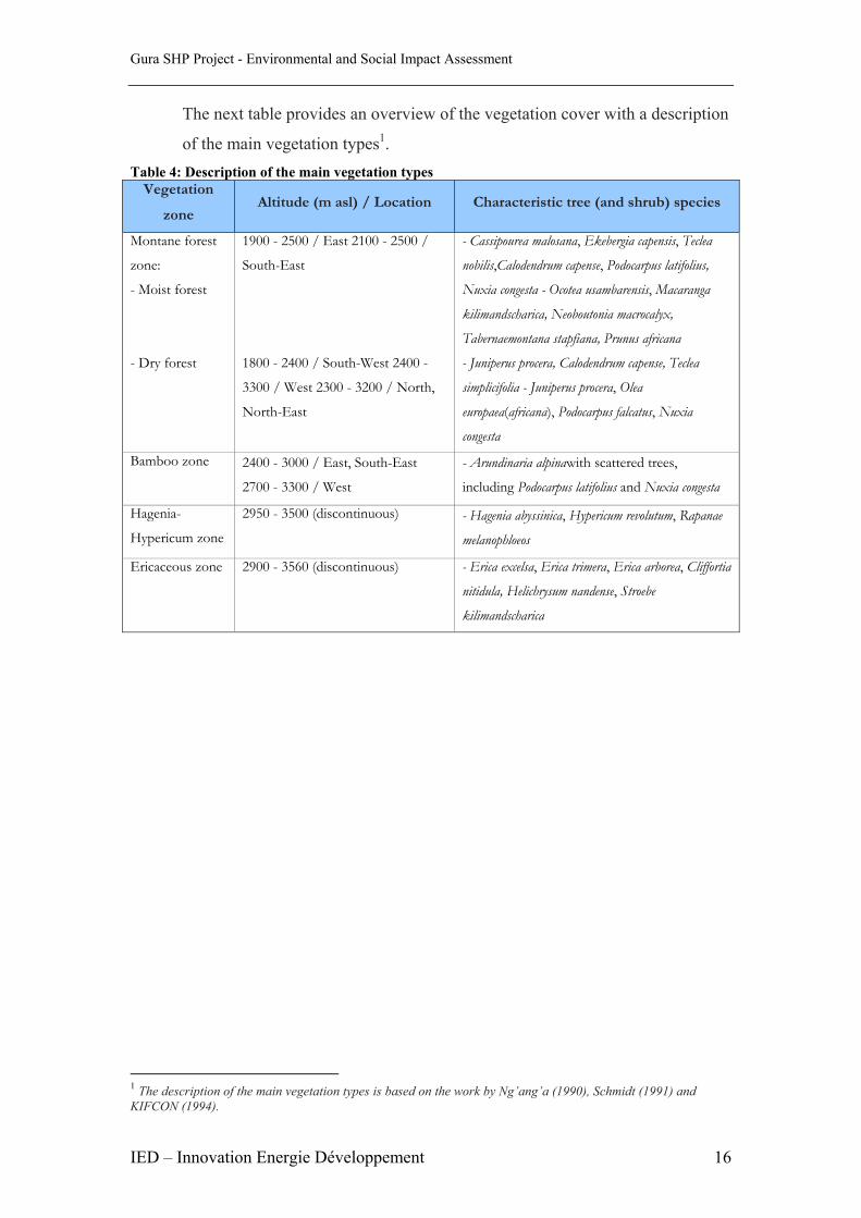
The next table provides an overview of the vegetation cover with a description
of the main vegetation types1. Table 4: Description of the main vegetation types
Vegetation
zone Altitude (m asl) / Location Characteristic tree (and shrub) species
Montane forest
zone:
- Moist forest
1900 - 2500 / East 2100 - 2500 /
South-East
- Cassipourea malosana, Ekebergia capensis, Teclea
nobilis,Calodendrum capense, Podocarpus latifolius,
Nuxia congesta - Ocotea usambarensis, Macaranga
kilimandscharica, Neoboutonia macrocalyx,
Tabernaemontana stapfiana, Prunus africana
- Dry forest 1800 - 2400 / South-West 2400 -
3300 / West 2300 - 3200 / North,
North-East
- Juniperus procera, Calodendrum capense, Teclea
simplicifolia - Juniperus procera, Olea
europaea(africana), Podocarpus falcatus, Nuxia
congesta
Bamboo zone 2400 - 3000 / East, South-East
2700 - 3300 / West
- Arundinaria alpinawith scattered trees,
including Podocarpus latifolius and Nuxia congesta
Hagenia-
Hypericum zone
2950 - 3500 (discontinuous) - Hagenia abyssinica, Hypericum revolutum, Rapanae
melanophloeos
Ericaceous zone 2900 - 3560 (discontinuous) - Erica excelsa, Erica trimera, Erica arborea, Cliffortia
nitidula, Helichrysum nandense, Stroebe
kilimandscharica
1 The description of the main vegetation types is based on the work by Ng’ang’a (1990), Schmidt (1991) and KIFCON (1994).

Gura SHP Project - Environmental and Social Impact Assessment
IED – Innovation Energie Développement 17
Figure 4: Kenya; Distribution of forest in provinces
The canal is located where the shamba system was practised and attempts have
been made at replanting thus the trees to be affected will be mainly re-planted
plantation species. The study identified the following species which will be
affected by the canal

Gura SHP Project - Environmental and Social Impact Assessment
IED – Innovation Energie Développement 18
Table 5: Affected tree species Item Description Quantity (nos)
1 Cypress - Cupressus lusitanica 200 2 “Mitundu” 80 3 Eucalyptus celigna 100 4 “Miiri” - Prunus africana 10 5 “Mikarariki” 20 6 “Miirere” 25
In addition the community use the forest for livestock grazing and collection
of fuel wood for domestic use.
There were anecdotal indications from discussions with the community that
there have been significant drop in illegal logging and charcoal burning
activities in the forest since the ban was effected in 2002 with more stringent
monitoring by the Kenya Forest Service (and its predecessor the Forestry
Department)

Gura SHP Project - Environmental and Social Impact Assessment
IED – Innovation Energie Développement 19
4.0 Social and Economics Information
4.1 General social considerations Any project that is developed should be justified by being socially desirable,
economically viable and environmentally sustainable. It is therefore critical
that for any project to ensure that emphasis are put on both environmental and
socio-economic impacts. In addition to direct environmental impacts of a
project, there are other equally substantial impacts and consequences with
respect to the social and environment of the people directly affected by the
development project
Wide-ranging discussions were held with all the 4 Tea Factories and
additionally with the District Administration and in particular the District
Development Office whereby the information was obtained on current social
economic data and attached is Appendix 7 with detailed socio-economic data
from the district fact sheet and from survey templates
4.2 Existing socio-economic situation in the project area.
The project is located in Mahiga Location of Othaya Division in Nyeri
District. The division has an area of 171 km2 comprising 5 locations and 20
sub-locations with a population density of 516 persons/km2 compared to a
district average of 202 persons/km2 (National Census; 1999)
Nyeri District is a predominantly agricultural area with small holder farms of
average size of 0.4 ha. The main cash crops are tea, coffee with some
horticultural crops (French beans, capsicum etc) and main food crops
produced comprising of maize, beans, Irish potatoes, bananas and cabbages.
However though socio –economic indicators like literacy show literacy levels
of 96% and 82% for males and females respectively, as with many parts of
Kenya unemployment is high at average of 40% over the district.
There are four main urban centres; Nyeri (which is also the Government
headquarters for Central Province ) , Karatina, Othaya and Naro Moru with
combined population of 175,000.
Some typical district information is tabulated below

Gura SHP Project - Environmental and Social Impact Assessment
IED – Innovation Energie Développement 20
Table 6: Typical District information (2002)2
Item Description Remark 1 Population (2002) 677,216 2 Population growth rate 0.8% 3 Average density 202 pers./km2 4 Total number of households 168, 786 5 Average household size 4 6 Average farm size 0.6Ha 7 Population growth rate 0.8% 8 Life Expectancy: Average 46 years
9 Sectoral contribution to household incomes- Agriculture 53%
10 Number of households with access to piped water 73%
11 Total enrolment rates – Boys - Girls
89% 86%
12 Number of households with electricity connections 11,053 13 Number of trading centres with electricity 74 14 %rural households using solar power 0.4% 15 % households using firewood/charcoal 80% 16 % households using kerosene, gas or biogas 90%
4.3 Engagement mechanisms for integrating the community in the project. (a) Establish community sensitization forums
Once it has been determined that the project will proceed formal
stakeholders sensitization meeting should be held and agreements reached
on regular mechanisms to inform the community on progress of the project
(b) Identify key areas of the project which have community roles and engage
the communities in those areas
During the stakeholders sensitization meeting community roles will be
discussed and developed where they can be engaged e.g. in employment
where possible, development and nurturing of tree nursery etc
2 Source: District Development Office, Nyeri, 2002.

Gura SHP Project - Environmental and Social Impact Assessment
IED – Innovation Energie Développement 21
5.0 Consultative Public Participation
5.1 Introduction It has become prudent practice to consult all stakeholders and more so the
communities directly affected by development projects to hear and understand their
views prior to implementation and adopt the recommendations in the designs thereof.
In this regard a meeting was called jointly by the Gathuthi Tea Factory Ltd and local
consultants Que Energy Ltd to inform and sensitize the farmers about the proposed
small hydro power development along Gura River. The meeting brought together the
local community of Gituiga sub–location3 and its environs, the Provincial
Administration, the Director and Management of Gathuthi Tea Factory and local
consultants Que Energy Ltd. The meeting was held at the Gituiga4 Tea Buying
Centre. In addition the consultants had carried out a social surveys and interacted
adequately with the community and sensitized them on the project aims
The meeting was well attended and attached Appendix 4 is the list of participants.
The meeting was moderated by the Director of Gathuthi Tea Factory ably assisted by
the Assistant Chief and the Factory Unit manager of Gathuthi Tea Factory
In addition the Consultants during the topographical and cadastral surveys regularly
engaged the community in discussions on what the project entailed. Accordingly a
survey was carried out along the whole project locations and typical templates are
attached Appendix 5
5.2 Summary of issues arising from the consultations The FUM and the consultants led the meeting through the genesis of the proposed
project and broadly the way it will be constructed and below are the issues arising
from the consultations
5.2.1 Compensation The community were keen to understand how they will be compensated for the land
and crops they will lose.
The consultants was explained that an independent Government Land Valuer, or if
the community strongly felt necessary engage a private Land Valuer , who will carry
out the exercise and tabulate the values therein of the land and crops they will forfeit.
3The Kenyan administrative set up is District, followed by Division then location, sub-location finally village. 4 Gituiga Tea Buying Centre is one of the tea collection centre for Gathuthi Tea Factory

Gura SHP Project - Environmental and Social Impact Assessment
IED – Innovation Energie Développement 22
The consultants added that the value of most items is now well known e.g. the factory
has a list with values of tea bushes of the different maturities and these are the figures
the valuer would base his compensation amount on. In addition the value of land
would be based on recent land sale values
The community requested the project to evaluate the possibility of supplying them
with water in lieu of cash or supply of power to the plots directly affected by the
construction through loss of land.
5.2.2 Safety The community strongly opposed having an open channel as they felt will be a risk to
themselves, their children and livestock. In addition they wanted to be advised where
the crossings over the channel would be. The Consultants pointed out that the issue
was of risk management and that covering the channel or provision of a fence would
carry a significant added cost to the project.
However the community felt an open channel posed a grave danger to them and the
consultants to evaluated the added costs to the project and the issue was to be
evaluated further by the consultants with a view of accommodating their concerns
5.2.3 Employment Opportunities The community through the Director noted that the locals will benefit from
employment opportunities which will ensue from the construction of the power
project. In addition the community agreed there would be long term benefits from the
transfer of skills and continued employment to run and maintain the project once
completed. However the community urged that locals be given priority when hiring of
labour. The consultant confirmed it is the Government policy that all unskilled labour
must be sourced from the locality of the project and in any case no contractor wishes
to bring external skills unless necessary as it is an additional expense.
5.2.4 Conclusion The meeting agreed that the project is beneficial to the community and noted that it
was an honour to be the first project to benefit for a full study from the GEF/EATTA
facility.
The participants requested and it was agreed consultations should be carried out
especially prior to commencement of construction works.
Gura SHP Project - Environmental and Social Impact Assessment
IED – Innovation Energie Développement 23
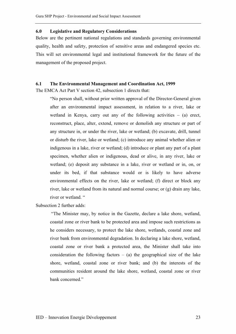
6.0 Legislative and Regulatory Considerations Below are the pertinent national regulations and standards governing environmental
quality, health and safety, protection of sensitive areas and endangered species etc.
This will set environmental legal and institutional framework for the future of the
management of the proposed project.
6.1 The Environmental Management and Coordination Act, 1999 The EMCA Act Part V section 42, subsection 1 directs that:
“No person shall, without prior written approval of the Director-General given
after an environmental impact assessment, in relation to a river, lake or
wetland in Kenya, carry out any of the following activities – (a) erect,
reconstruct, place, alter, extend, remove or demolish any structure or part of
any structure in, or under the river, lake or wetland; (b) excavate, drill, tunnel
or disturb the river, lake or wetland; (c) introduce any animal whether alien or
indigenous in a lake, river or wetland; (d) introduce or plant any part of a plant
specimen, whether alien or indigenous, dead or alive, in any river, lake or
wetland; (e) deposit any substance in a lake, river or wetland or in, on, or
under its bed, if that substance would or is likely to have adverse
environmental effects on the river, lake or wetland; (f) direct or block any
river, lake or wetland from its natural and normal course; or (g) drain any lake,
river or wetland. “
Subsection 2 further adds:
“The Minister may, by notice in the Gazette, declare a lake shore, wetland,
coastal zone or river bank to be protected area and impose such restrictions as
he considers necessary, to protect the lake shore, wetlands, coastal zone and
river bank from environmental degradation. In declaring a lake shore, wetland,
coastal zone or river bank a protected area, the Minister shall take into
consideration the following factors – (a) the geographical size of the lake
shore, wetland, coastal zone or river bank; and (b) the interests of the
communities resident around the lake shore, wetland, coastal zone or river
bank concerned.”

Gura SHP Project - Environmental and Social Impact Assessment
IED – Innovation Energie Développement 24
Further according to section 45 of the Act, hilly or mountainous areas are at risk and
District Environmental Committees are encouraged to initiate self-help conservation
activities for such areas with section 47 giving further guidelines on these measures.
The conservation and management of forests is covered under sections 48 to 51 which
state inter alia;
“48 (2) The Director-General shall not take any action, in respect of any forest
or mountain area, which is prejudicial to the traditional interests of the
indigenous communities customarily resident within or around such forest or
mountain area.”;
“51 (b) The Authority shall, in consultation with the relevant lead agencies,
prescribe measures adequate to ensure the conservation of biological resources
in-situ and in this regard shall issue guidelines for the selection and
management of protected areas so as to promote the conservation of the
various terrestrial and aquatic ecosystems under the jurisdiction of Kenya“.
6.2 Water Act 2002 Section 25 part 1 describes the Water rights and permit requirements and states
“A permit shall be required for any of the following purposes:
(a) Any use of water from a water resource as provided by section section26
(b) The drainage of any swamp or other land
(c) The discharge of a pollutant into any water resource
(d) Any purpose to be carried out in or in relation to a water resource which is
presided by the rules made under this act to be a purpose for which a
permit is required”
Additionally Sections 28, 29 and 30 give further particulars on the specific licence
and permit requirements
Accordingly the proponent through the Regional Manager, KTDA applied for an
abstraction permit to the Regional Manager of the regulatory authority; Water
Resource Management Authority (WRMA) and the specific requirements are listed
below and copy of letter is attached Appendix 6:
1. Cadastral maps showing the location of the factories and points of intakes
for the water works
2. Two topographical sheets 134/2 showing the points of intake

Gura SHP Project - Environmental and Social Impact Assessment
IED – Innovation Energie Développement 25
3. Title deeds for the plots where the water works will be constructed
4. Certificates of incorporation
5. Letters of no objection from owners of plots in (3) above if plots are not
owned by the applicant themselves
6. The feasibility study report
7. Application fee of Kshs 42,000.00
8. A letter of no objection from Kenya Forestry Service for entering the
forest
6.3 Forest Act 2005 The part of the project in the Aberdare Forest will be governed by the new Forest Act
2005. Some of the sections applicable to authorization are inter alia;
Part 3 section 32 which states:
“(1) Any forest community, or person who is desirous of utilizing or
conserving any grove or forest which is part of a nature reserve for cultural,
religious, educational, scientific or other reasons shall submit an application,
in the prescribed form, to the board through the forest conservation committee
for the area in which the nature reserve occurs.
(2) Upon receipt of the application referred to in subsection (1), the Board
shall make inquiries regarding the application, including the authenticity of the
application and the suitability of the site vis-a –vis the activities for which the
application is made, and, based on such inquiry, the Board may within three
months of receipt of the application –
a) grant the application as requested;
b) grant the application on specified terms and conditions; or
c) refuse to grant the application, giving reasons for such refusal.
Section 39 which states:
(1) Where the Board is satisfied that utilization of a forest can be done
through the granting of concessions, the Service may, by licence, grant the
same subject to an Environmental Impact Assessment Licence in accordance
with the Environmental Management and Coordination Act, 1999.

Gura SHP Project - Environmental and Social Impact Assessment
IED – Innovation Energie Développement 26
(2) In addition to subsection (1), the grantee of a concession shall:-
a) comply with the guidelines or management plans prescribed by the
Service;
b) protect the concession area from destruction and encroachment by
other persons;
c) ensure that the forest areas under his management are maintained for
the conservation of biodiversity, cultural or recreational use;
d) maintain the physical boundaries of the concession;
e) take precautions to prevent the occurrence and spread of forest fires in
connection with any or all operations within or outside the
concession area; and
f) ensure that all structures and facilities constructed or operated by and
in connection with any activities are maintained according to the
conditions of the licence.
(3) The licence shall indicate the nature of the concession, including its
physical location and boundaries, and the purpose for which it is granted.
(4) The Board may withdraw a concession granted under this section where a
grantee breaches any of the conditions prescribed under subsection (2).
(5) A grantee of a concession under this section shall be held personally
responsible for any damage, including the negligence of his employees, arising
directly from his operations on the land for which the concession has been
obtained.
6.4 Health and safety regulations; Public Health Act (Cap 242) Part IX section 115 of the Public Health Act (Cap 242) states that no
person/institution shall cause nuisance or condition liable to be injurious or
dangerous to human health. Any noxious matter or waster water flowing or
discharged into a watercourse is deemed as a nuisance. Part XII Section 136
states that all collections of water, sewerage, rubbish, refuse and other fluids
which permits or facilitates the breeding or multiplication of pests shall be
deemed nuisances.
This Act generally addresses matters of sanitation, hygiene and general
environmental health and safety
Gura SHP Project - Environmental and Social Impact Assessment
IED – Innovation Energie Développement 27
6.5 The Energy Act 2006
The licensing of generation and transmission of electricity falls under the
regulatory authority of the Electricity Regulatory Commission (ERC) under
the Energy Act 2006. The requirements are under Part III section 27 which
state :
“Requirements for a licence or permit.
27. (1) Subject to the provisions of this Act, a licence or licences as the case
may be, shall be required for the–
(a) generation, importation or exportation, transmission or distribution
of electrical energy; or
(b) supply of electrical energy to consumers:
Provided that for undertakings involving a capacity not exceeding 3,000 kW,
the provisions of subsections (2), (3) and (4) shall apply.
(2) A Permit shall be required in respect of all undertakings–
(a) intended for the supply of electrical energy to other persons or
consumers; and
(b) with a generating plant of over 1000 kW intended for own use.
(3) Any undertaking operating pursuant to a permit granted under this Act
shall–
(a) in any case where conveyance of electrical energy to or from any
transmission or distribution network is possible, meet the minimum
requirements of the owner or operator of the transmission or
distribution network as approved by the Commission, and the owner or
operator of any such undertaking shall inform the network owner or
operator of all connected load and generation equipment that might
have material effect on the network; and
(b) be subject to such conditions as may be specified by the
Commission
There are the other sections namely sections
Additional requirements for implementation namely applications,
transfers electrical installation etc are contained from sections 28 to 42
of Part III.

Gura SHP Project - Environmental and Social Impact Assessment
IED – Innovation Energie Développement 28
7.0 Environmental Management Plan
7.1 Overview The project is geared towards provision of power for Gathuthi, Chinga, Gitugi and
Iriani Tea factories, and for people living within the area and the neighbourhood of
the project at large
The project should also observe environmental requirements in accordance with legal
and statutory requirements
To achieve this goal, acceptability by a majority of the beneficiaries with minimal
effects to the physical environment will require to be integrated in the project through
constant consultations, evaluations and review of the design aspects where applicable
7.2 General impacts Among the factors that need to be considered in this particular project
implementation and its post evaluation initiatives will include;
a) Preservation of the natural beauty of the forest and countryside along the canal
route.
b) Control of soil erosion and siltation of Gura River and other public sources of
water
c) Enhancing integration of environmental, social and economic functions in the
project design and implementation
d) Incorporation of safety provisions in the design and construction including
accessibility to the users, livestock…etc.
The project is an economic good for Tea factories, the people living in the area and
the country in general and no significant negative issues are anticipated on
environmental, economic and social well-being on the whole. However the
community expressed strong feeling about safety along the canal and this needs to be
addressed.
In order to implement the management plan, it is recommended that a position is
created of appropriate expertise to oversee environment and social management of re-
planting of trees and other vegetation along the canal route, the recovery of any
eroded areas, enhanced safety measures and general liaison with the community
Gura SHP Project - Environmental and Social Impact Assessment
IED – Innovation Energie Développement 29
during and post construction period. This environmental manager/officer would be
under the responsibility of the consultants superintending the construction of the
project and the management of the power company thereon should their services
continue to be required.
7.3 ESMP matrix
The following is a matrix (tables 4 a-b-c) providing specific actions on mitigating
significant impacts with the actions are recommendations on timeframe and those
responsible in leading the way. It is important to note that costs are estimated and
will be firmed up by each specific activity at time of implementation.
To keep track of the successes of the management plan, targets and monitorable
indicators have also been provided.

30
Table 4a: Environmental Management Plan (Part 1) Item Anticipated Impacts and Proposed Actions Responsibility Costs ( Kshs) Targets to Achieve Monitorable No. Sources and Timeframe Indicators1 Degradation of water sources: • Observe stipulated The contractor, • Minimal • Physical • Over-abstraction of water, utilization regulations (water discharging into quality downstream • Water quality abstraction, slope excavations, The Project water bodies, of road, from siltation, hydrocarbon etc.) Resident Approx • Status of residuals, 2,000,000.00 • No effects on rivers and wetlands • Effects on • Monitor standards of For the whole physical status downstream of the dependants (people and at the construction camps, Project period of water quality, roads reserve aquatic systems), • Complaints • Establish a mechanism for Immediate • Centralised the neighbouring Sources: waste collection, storage, and collection of communities or the • Silt from earth moving, transfer and disposal. throughout solid wastes at authorities. • Oil and grease project period. camps and final construction machinery, disposal Site workshops and machinery maintenance areas, 2. Air quality: • Invest in constant watering of The Contractor Nil visible • Dust level • Dust and particle matter, access roads and other areas particulate matter in the project, • Visual disruption, construction, the diversions and The Project Approx the air. • Exhaust fumes form • Smoke and dry materials, Resident 2,000,000.00 construction residual emissions, Payable monthly . • Inhibition of crop pollination • Establish against activity (reduced farm productivity), dissemination process to the • Surface depositions, communities on potential dusty • Bronchial and eye problems conditions, the communities. Throughout • Keep inevitable construction Sources: conditions and/or emissions as period Construction activities short as possible, moving and operations).

Gura SHP Project - Environmental and Social Impact Assessment
IED – Innovation Energie Développement 31
Table 4b: Environmental Management Plan (Part 2) Item Anticipated Impacts and Proposed Actions Responsibility Targets to Achieve Monitorable No. Sources and Timeframe Indicators 3 Vegetation cover degradation: • Initiate a trees nursery and Reinstate the Well established trees • Removal of trees from tree planting in collaboration The Contractors Approx vegetation cover the intake and canal route with the tea factories, the Kenya along the Community participation • Removal of vegetation clearance Forestry Service and Resident Engineer 10,000,000.00 project to near its from canal route, power house and relevant government organs, To also cover original status. Greenery along the and forebay sites, financiers and experts. maintenance route of access roads. period post Re-planting and Sources: • Undertake top-soiling and construction well established Forest and farms grassing programme for any trees by project end access road reserve 4 Environmental Pollution: • Develop and document The Contractor Minimal disruption • Physical water • Erosion and loss of soil, Standard Operating Procedures to physical and quality, • Siltation of water bodies, (SOPs), schedules and Resident Engineer Approx biological • Affected • Pollution of water and soil (turbidity supervision guidelines for the 3,000,00.00 environmental environmental and hydrocarbons), project, Including study quality throughout features, • Visual pollution (from dust for SOP the route. • Environmental and emissions), • Identify sensitive and safety for health risks, Soil waste spoiling environmental features (e.g. accidental spill • Waste from construction Sources: river/stream crossings) for and camp sites and their • Oil/grease leaks from necessary precautions, ultimate destinations machineries, • Solid waste disposal (filters, • Establish a programme of waste Risks from camp sites, greases, asphalt wastes, etc.), management and dust control service yards and • Construction machinery, throughout construction period. Hydro-carbon working excavations and vehicles. yards.6 Land degradation: • Initiate a vegetation programme The Contractor, Conservation of • Soil loss, on canal route, Approx soils on each side of A project wide • Soil quality degradation, The Resident 1,000,000.00 for the canal throughout concern Source: Engineer scour checks etc • Channeling surface runoff • Draw rehabilitation plans of away from natural drainage reflect this aspect. lines),

Gura SHP Project - Environmental and Social Impact Assessment
IED – Innovation Energie Développement 32
Table 4c: Environmental Management Plan (Part 3) Item Anticipated Impacts and Proposed Actions Responsibility Costs Targets to Achieve MonitorableNo. Sources and Timeframe Indicators7 Health and Safety • Initiate a safety programme for The Contractor, Information flow Complaints on health • Personal injuries (construction all construction sites and working Approx and dissemination safety aspects related employees), areas involving information, The Resident 2,000,000.00 on health and safety. to the road construction • Communicable diseases awareness and physical Engineer for HIV/AIDS activities. (workers and local protection training etc Specific response to communities), To be initiated HIV/AIDS issues • Accidental falls into canal and • Initiate awareness creation immediately and Health care and intake program among the workers continue accidents under • Environmental diseases and residents on HIV/AIDS and throughout the insurance cover (bronchial and eye problems), other infectious diseases, project period. of contractor Sources: • Construction dust and emissions, • Social interaction of construction workers and the • Provide' medical, insurance local communities, cover and PPEs for all the • Pollution of water from construction workers. construction activities. 8 Social and Economic: The Resident An acceptable, Trends in socio- • Temporary disruption of • Enhance consultations with Engineer sustainable and economic dynamics river flows communities on activities in conjunction Approx economically viable within the area • Public disaffection from the affecting them and collaborate with the 300,000.00 for road with long term project implementation on the impacts reduction, Contractor, communication benefits to the insensitivity, and dissemination people without • Benefits to the riparian • Establish modalities of Liaison with local adverse implications communities (employment, recruiting manual labour from authorities and the on the physical and trade, etc.) within the project area. Provincial biological Administration, environment. Sources: • Coffer dams Action within the project implementation period

33
8.0 Conclusion
On the basis of the assessment undertaken, there are no major environmental negative
impacts and the project benefits overrides the anticipated environmental and social
impacts. A comprehensive environmental and social management plan has provided a
schedule of activities to achieve and guide these mitigation and legal measures
The detailed feasibility study for Gura MHP Project shows the project is economically
and technically viable

Gura SHP Project - Environmental and Social Impact Assessment
IED – Innovation Energie Développement 34
APPENDICES

Gura SHP Project - Environmental and Social Impact Assessment
IED – Innovation Energie Développement 35
Appendix 1: Pictures of Gura Hydropower Site Request for NEMA TOR Approval

Gura SHP Project - Environmental and Social Impact Assessment
IED – Innovation Energie Développement 36
NEMA TOR Approval (page 1)

Gura SHP Project - Environmental and Social Impact Assessment
IED – Innovation Energie Développement 37
NEMA TOR Approval (page 2)

Gura SHP Project - Environmental and Social Impact Assessment
IED – Innovation Energie Développement 38
NEMA TOR Approval (page 3)

Gura SHP Project - Environmental and Social Impact Assessment
IED – Innovation Energie Développement 39
Appendix 2: Pictures of Gura Hydropower Site
Plate 1: Typical Forest Cover which will be affected by channel
Plate 2: Intake location

Gura SHP Project - Environmental and Social Impact Assessment
IED – Innovation Energie Développement 40
Plate 3a: Typical Farming Activities- Tea growing and dairy farming
Plate 3b: Typical Farming Activities- Tea growing and dairy farming
Gura SHP Project - Environmental and Social Impact Assessment
IED – Innovation Energie Développement 41
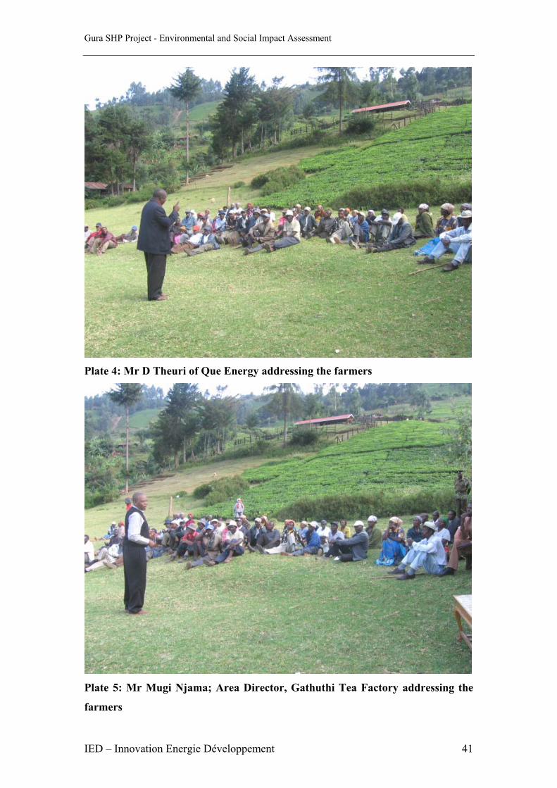
Plate 4: Mr D Theuri of Que Energy addressing the farmers
Plate 5: Mr Mugi Njama; Area Director, Gathuthi Tea Factory addressing the
farmers

Gura SHP Project - Environmental and Social Impact Assessment
IED – Innovation Energie Développement 42
Appendix 3: Nyeri Administrative Boundaries

Gura SHP Project - Environmental and Social Impact Assessment
IED – Innovation Energie Développement 43
Appendix 4: Attendance List at Consultative Meeting

Gura SHP Project - Environmental and Social Impact Assessment
IED – Innovation Energie Développement 44

Gura SHP Project - Environmental and Social Impact Assessment
IED – Innovation Energie Développement 45

Gura SHP Project - Environmental and Social Impact Assessment
IED – Innovation Energie Développement 46

Gura SHP Project - Environmental and Social Impact Assessment
IED – Innovation Energie Développement 47
Appendix 5: Social Survey Template Typical social survey template
Example of filled social survey template

Gura SHP Project - Environmental and Social Impact Assessment
IED – Innovation Energie Développement 48

Gura SHP Project - Environmental and Social Impact Assessment
IED – Innovation Energie Développement 49
Appendix 6: Water Abstraction Request

Gura SHP Project - Environmental and Social Impact Assessment
IED – Innovation Energie Développement 50
Appendix 7: Nyeri District Fact Sheet

Gura SHP Project - Environmental and Social Impact Assessment
IED – Innovation Energie Développement 51

Gura SHP Project - Environmental and Social Impact Assessment
IED – Innovation Energie Développement 52

Gura SHP Project - Environmental and Social Impact Assessment
IED – Innovation Energie Développement 53