Enhanced Loran (eLoran - rntfnd.org Enhanced Loran (eLoran) Definition Document has been published...
17
Enhanced Loran (eLoran) Definition Document For Consultation - Comments to ILA by 1 April Report Version: 0.1 Report Version Date: 12 January 2007
Transcript of Enhanced Loran (eLoran - rntfnd.org Enhanced Loran (eLoran) Definition Document has been published...

Enhanced Loran (eLoran)Definition Document For Consultation - Comments to ILA by 1 April
Report Version: 0.1 Report Version Date: 12 January 2007
eLoran Definition Document For Consultation - Comments to ILA by 1 April
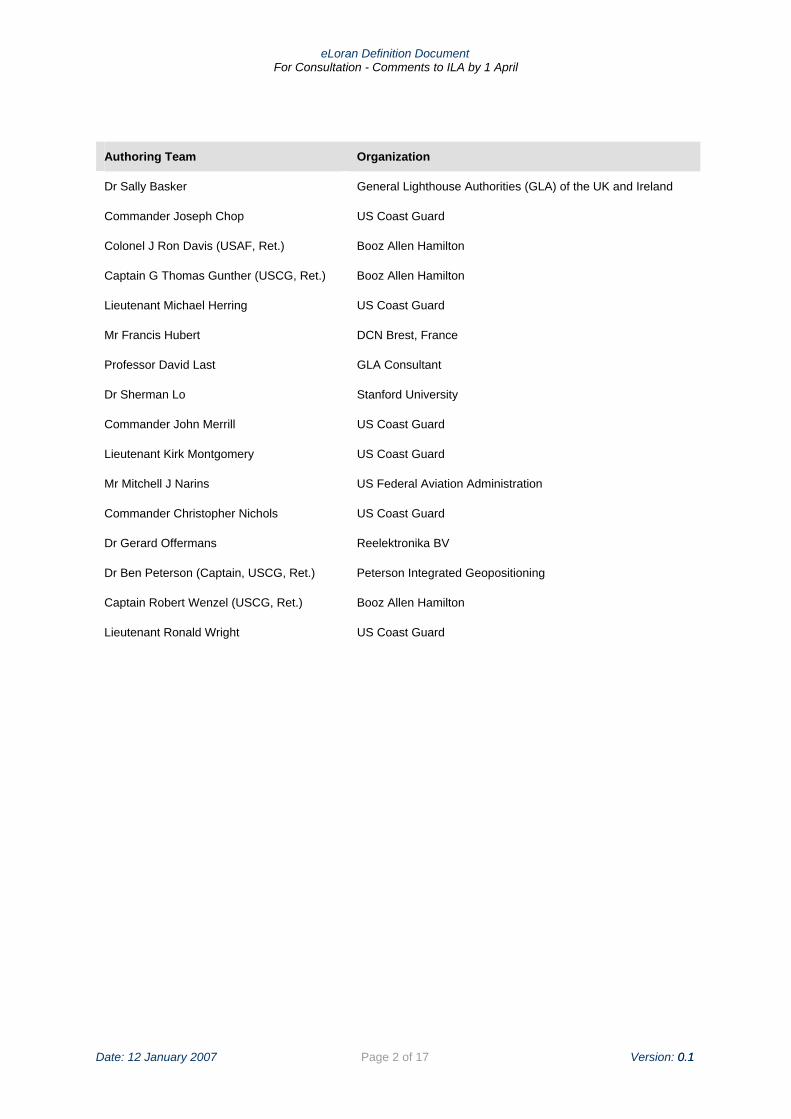
Authoring Team Organization
Dr Sally Basker General Lighthouse Authorities (GLA) of the UK and Ireland
Commander Joseph Chop US Coast Guard
Colonel J Ron Davis (USAF, Ret.) Booz Allen Hamilton
Captain G Thomas Gunther (USCG, Ret.) Booz Allen Hamilton
Lieutenant Michael Herring US Coast Guard
Mr Francis Hubert DCN Brest, France
Professor David Last GLA Consultant
Dr Sherman Lo Stanford University
Commander John Merrill US Coast Guard
Lieutenant Kirk Montgomery US Coast Guard
Mr Mitchell J Narins US Federal Aviation Administration
Commander Christopher Nichols US Coast Guard
Dr Gerard Offermans Reelektronika BV
Dr Ben Peterson (Captain, USCG, Ret.) Peterson Integrated Geopositioning
Captain Robert Wenzel (USCG, Ret.) Booz Allen Hamilton
Lieutenant Ronald Wright US Coast Guard
Date: 12 January 2007 Page 2 of 17 Version: 0.1 0.1

eLoran Definition Document For Consultation - Comments to ILA by 1 April
Executive Summary
Overview This Enhanced Loran (eLoran) Definition Document has been published by the International Loran Association to provide a high-level definition of eLoran for policy makers, service providers, and users. It was developed in November 2006 at the United States Coast Guard Navigation Center by an international team of authors.
Enhanced Loran is an internationally-standardized positioning, navigation, and timing (PNT) service for use by many modes of transport and in other applications. It is the latest in the long-standing and proven series of low-frequency, LOng-RAnge Navigation (LORAN) systems, one that takes full advantage of 21st century technology.
eLoran meets the accuracy, availability, integrity, and continuity performance requirements for aviation non-precision instrument approaches, maritime harbor entrance and approach maneuvers, land-mobile vehicle navigation, and location-based services, and is a precise source of time and frequency for applications such as telecommunications1.
eLoran is an independent, dissimilar, complement to Global Navigation Satellite Systems (GNSS). It allows GNSS users to retain the safety, security, and economic benefits of GNSS, even when their satellite services are disrupted.
The eLoran System eLoran meets a set of worldwide standards and operates wholly independently of GPS, GLONASS, Galileo, or any future GNSS. Each user’s eLoran receiver will be operable in all regions where an eLoran service is provided. eLoran receivers shall work automatically, with minimal user input.
The core eLoran system comprises modernized control centers, transmitting stations and monitoring sites. eLoran transmissions are synchronized to an identifiable, publicly-certified, source of Coordinated Universal Time (UTC) by a method wholly independent of GNSS. This allows the eLoran Service Provider to operate on a time scale that is synchronized with but operates independently of GNSS time scales. Synchronizing to a common time source will also allow receivers to employ a mixture of eLoran and satellite signals.
The principal difference between eLoran and traditional Loran-C is the addition of a data channel on the transmitted signal. This conveys application-specific corrections, warnings, and signal integrity information to the user’s receiver. It is this data channel that allows eLoran to meet the very demanding requirements of landing aircraft using non-precision instrument approaches and bringing ships safely into harbor in low-visibility conditions. eLoran is also capable of providing the exceedingly precise time and frequency references needed by the telecommunications systems that carry voice and internet communications.
eLoran Service Provision eLoran services are provided by a Core eLoran Service Provider and various Application Service Providers:
• Core eLoran Service Provider – delivering a highly precise version of the core signal originally described in the US Coast Guard Specification of the Transmitted Loran-C Signal; and
1 Loran's Capability to Mitigate the Impact of a GPS Outage on GPS Position, Navigation, and Time Applications; Prepared for the Federal Aviation Administration, Vice President for Technical Operations, Navigation Services Directorate; dated March 2004
Date: 12 January 2007 Page 3 of 17 Version: 0.1

eLoran Definition Document For Consultation - Comments to ILA by 1 April
• Application Service Providers – (e.g. aviation, maritime, etc …) delivering application-specific data (e.g. differential Loran messages or early skywave warnings) that may be communicated using the eLoran data channel.
eLoran’s enhanced accuracy, availability, integrity and continuity meets the requirements for aviation non-precision instrument approaches, maritime harbor entrance and approach maneuvers, land-mobile vehicle navigation, and location-based services. It also allows absolute UTC time to be recovered with an accuracy of 50 nanoseconds as well as meeting the Stratum 1 frequency standard needed by telecommunications users.
Accuracy Availability Integrity Continuity
0.004 – 0.01 nautical mile (8 – 20 meters)
0.999 – 0.9999 0.999999 (1 x 10⁻⁷)
0.999 – 0.9999 over 150 seconds
Notes: 1. Accuracy to meet maritime harbor entrance and approach 2. Availability, integrity and continuity to meet aviation non-precision approach in the U.S.
eLoran System Performance Requirements
eLoran services will deliver safety, security and economic benefits to a wide range of stakeholders (e.g. governments, service providers) and users (e.g. aviation, maritime):
• allowing aviation communications, navigation and surveillance functions to migrate to digital communications;
• enabling maritime e-Navigation including permanent or temporary virtual AtoNs to be used to mark dangerous waters;
• supporting road user charging providing authentication; and
• maintaining synchronization of wired and wireless telecommunications without the need for expensive external oscillators.
The Way Ahead eLoran is an independent, dissimilar complement to GNSS. As such, it will allow PNT users with demanding safety-critical or mission-critical applications to secure their safety, security and economic benefits even when their satellite services are disrupted.
eLoran is capable of meeting the accuracy, availability, integrity, and continuity performance requirements for:
• aviation non-precision instrument approaches;
• maritime harbor entrance and approach maneuvers;
• land-mobile vehicle navigation;
• location-based services; and
• precise time and frequency users.
This document, the first of several needed to fully define the system, marks the beginning of an international effort to secure accurate and reliable sources of PNT for 21st century users with demanding safety-critical or mission-critical applications.
Date: 12 January 2007 Page 4 of 17 Version: 0.1

eLoran Definition Document For Consultation - Comments to ILA by 1 April
Contents
1 Introduction ............................................................................................................................ 7 1.1 Overview......................................................................................................................... 7 1.2 Background..................................................................................................................... 7 1.3 Contents ......................................................................................................................... 8
2 The eLoran System................................................................................................................ 8 2.1 eLoran Signal.................................................................................................................. 9 2.2 Transmitting Stations .................................................................................................... 10 2.3 Control Centers............................................................................................................. 10 2.4 Monitor Sites/Reference Stations.................................................................................. 10 2.5 Users’ Equipment.......................................................................................................... 10
3 Applications.......................................................................................................................... 11 3.1 Overview....................................................................................................................... 11 3.2 Aviation ......................................................................................................................... 11 3.3 Maritime ........................................................................................................................ 12 3.4 Land Mobile .................................................................................................................. 14 3.5 Location-Based Services .............................................................................................. 14 3.6 Time & Frequency......................................................................................................... 15
4 eLoran Service Provision ..................................................................................................... 15 4.1 Documentation.............................................................................................................. 17
5 Conclusion ........................................................................................................................... 17
Date: 12 January 2007 Page 5 of 17 Version: 0.1

eLoran Definition Document For Consultation - Comments to ILA by 1 April
Acronyms
ADS-B Automatic Dependent Surveillance – Broadcast (aviation)
AIS Automatic Identification System (maritime)
AtoN Aid to Navigation (maritime)
CNS Communications, Navigation, Surveillance (aviation)
ECDIS Electronic Chart Display Information System
eLoran Enhanced Loran
FAA Federal Aviation Administration
GLA General Lighthouse Authorities
e-Navigation Enhanced Navigation (maritime)
GNSS Global Navigation Satellite System
GPS Global Positioning System
ICAO International Civil Aviation Organization
IEC International Electrotechnical Commission
IMO International Maritime Organization
ITU International Telecommunications Union
Loran LOng-RAnge Navigation
MOPS Minimum Operational Performance Standards
PNT Positioning, Navigation, and Timing
P-Static Precipitation Static
Ret Retired
RNAV Area Navigation (aviation)
RNP Required Navigation Performance
SSX Solid State Transmitter
UPS Uninterruptible Power Supply
US United States of America
USCG US Coast Guard
UTC Coordinated Universal Time
WWRNS World Wide Radionavigation System
Date: 12 January 2007 Page 6 of 17 Version: 0.1
eLoran Definition Document For Consultation - Comments to ILA by 1 April
1 Introduction
This Enhanced Loran (eLoran) Definition Document has been produced by the International Loran Association to provide a high-level definition of eLoran for policy makers, service providers, and users. It first describes the eLoran system, signal, and users’ receivers. It focuses in turn on how eLoran is employed to navigate in the air, at sea, and on land, and then on the use of eLoran in location-based services as well as a source of highly precise time and frequency. This document will be followed by others produced by various bodies, including a signal specification and a set of receiver performance standards for the various applications.
1.1 Overview Enhanced Loran is an internationally standardized positioning, navigation, and timing (PNT) service for use by many modes of transport and in other applications. It is the latest in the long-standing and proven series of low-frequency, LOng-RAnge Navigation (LORAN) systems, one that takes full advantage of 21st century technology.
eLoran meets the accuracy, availability, integrity, and continuity performance requirements for aviation non-precision instrument approaches, maritime harbor entrance and approach maneuvers, land-mobile vehicle navigation, and location-based services, and is a precise source of time and frequency for applications such as telecommunications2.
eLoran is an independent, dissimilar, complement to Global Navigation Satellite Systems (GNSS). It allows GNSS users to retain the safety, security, and economic benefits of GNSS, even when their satellite services are disrupted.
1.2 Background The predecessor of eLoran, Loran-C, delivered a positioning accuracy of 460 meters3, principally to mariners sailing in coastal and oceanic waters. When the Global Positioning System (GPS) appeared in the1980s, with its positioning accuracy of tens of meters, many began to regard Loran-C as irrelevant. However, others saw it as an essential source of position and time that could still be relied upon if GPS failed.
In September 2001, almost simultaneously with the “9/11” act of terrorism, the US Government published its “Volpe Report”4. This spelled out the degree to which the US, like other nations worldwide, was starting to base its critical infrastructures on GPS. The Report explained the vulnerability of GPS (and similar GNSS systems) to disruption by intentional or unintentional interference. It identified Loran as a potential solution to this important problem. This attracted interest worldwide, and provided an impetus to modernize the Loran system in the US.
The US Loran evaluation and modernization program5 resulted in this new version of Loran with significantly improved performance. It has much better accuracy, integrity, and continuity while continuing to meet Loran-C’s traditional availability requirements (Table 1). These improvements are realized mainly through the addition of a data channel. This data channel allows eLoran to meet the very demanding requirements of landing aircraft using so-called non-precision instrument approaches, and bringing ships safely into harbor in low-visibility conditions. eLoran was also shown to be capable of providing the exceedingly precise time and frequency
2 Loran's Capability to Mitigate the Impact of a GPS Outage on GPS Position, Navigation, and Time Applications; Prepared for the Federal Aviation Administration, Vice President for Technical Operations, Navigation Services Directorate; dated March 2004 3 2005 Federal Radionavigation Systems. US Department of Defense, US Department of Transportation, and US Department of Homeland Security 4 Vulnerability Assessment of the Transportation Infrastructure relying on the Global Positioning System. John A Volpe National Transportation Systems Center. Final Report. August 2001. 5 A program directed by the US Congress through the budget appropriation process, which began in 1997 and has continued through the current fiscal year, totaling ~$160 M to date.
Date: 12 January 2007 Page 7 of 17 Version: 0.1

eLoran Definition Document For Consultation - Comments to ILA by 1 April
references needed by the telecommunications systems that carry voice and internet communications.
Accuracy Availability Integrity Continuity
0.004 – 0.01 nautical mile (8 – 20 meters)
0.999 – 0.9999 0.999999 (1 x 10⁻⁷)
0.999 – 0.9999 over 150 seconds
Notes: 1. Accuracy to meet maritime harbor entrance and approach 2. Availability, integrity and continuity to meet aviation non-precision approach in the US 3. eLoran meets ITU requirements in G.811 for primary reference clocks6
Table 1 – eLoran System Performance Requirements
One of the data channel messages is used to provide real-time differential corrections. These corrections are provided via reference stations that detect tiny variations in the eLoran signal, similar to the differential GNSS reference stations, allowing receivers to correct for these variations as well as providing information regarding signal integrity.
eLoran has the potential to back up GNSS, taking over seamlessly if the satellite signals are lost, thus allowing users to continue to operate and keeping communications and surveillance systems running.
As eLoran uses high-powered transmitters and low-frequency signals (not microwatts and microwaves like GNSS), it is very unlikely to be interfered with or jammed by the same causes that would disrupt GNSS signals. This means that small, low-cost, eLoran receivers, even built into GNSS units, can mitigate the impact of disruptions to GNSS. Moreover, eLoran can do things GNSS cannot, such as acting as a static compass. At sea, a new concept of navigation – enhanced navigation (e-Navigation) – is being developed which requires an exceptionally reliable input of position, navigation, and time data. Uniquely, the combination of GNSS and eLoran has the potential to meet its needs.
eLoran is the culmination of technical developments undertaken world-wide over the past two decades, which now meets the very demanding requirements of 21st century users.
1.3 Contents In this document, Section 2 will introduce the eLoran system and its signal, the transmitting stations, the monitoring and control arrangements, and the user equipment. In Section 3, the use of eLoran in aviation, maritime, land mobile, and location-based services, and time and frequency applications will be illustrated as well as the safety, security, and economic benefits offered by eLoran within each of these applications. Section 4 will discuss the eLoran Service Provision as well as the technical documentation that is needed to fully define the performance of the eLoran system.
2 The eLoran System
eLoran meets a set of world-wide standards and will run wholly independently of GPS, GLONASS, Galileo, or any future GNSS. Each user’s eLoran receiver will be operable in all regions where eLoran service is provided. eLoran receivers shall work automatically, with minimal user input.
The foundation for the eLoran signal is the US Coast Guard Specification of the Transmitted Loran-C Signal7. However, for eLoran use, many of the tolerances have been tightened in order to ensure that eLoran meets the new, much higher, standards. Details of these changes will be
6 Timing Characteristics of Primary Reference Clocks. International Telecommunications Union, G.811, September 1997 7 Specification of the Transmitted LORAN-C Signal, United States Coast Guard, COMDTINST M16562.4A, 1994
Date: 12 January 2007 Page 8 of 17 Version: 0.1

eLoran Definition Document For Consultation - Comments to ILA by 1 April
specified in later documents. The change to eLoran will not preclude the continued use of legacy Loran-C receivers, but legacy users will not benefit from the additional data channel capabilities of eLoran.
Figure 1 – eLoran System Concept
Because eLoran signals travel over the surface of the earth (i.e., they are groundwaves), they are subject to small propagation delays that depend on the electrical conductivity of the ground. To achieve the high level of accuracy required for aviation approaches, harbor entrance and approach maneuvers, and to recover precise time, these propagation delays must be measured and the corrections must be applied. User and System Monitor Receivers will store and employ these Signal Propagation Corrections to maximize the accuracy and also provide integrity for the solutions they deliver.
2.1 eLoran Signal The principal difference between the eLoran transmitted signal and the traditional Loran-C signal is the addition of a data channel. The data channel conveys corrections, warnings, and signal integrity information to the user’s receiver via the Loran transmission. The data transmitted may not be needed for all applications but will include at a minimum:
• The identity of the station; an almanac of Loran transmitting and differential monitor sites;
• Absolute time based on the Coordinated Universal Time (UTC) scale; leap-second offsets between eLoran system time and UTC;
• Warnings of anomalous radio propagation conditions including early skywaves; warnings of signal failures, aimed at maximizing the integrity of the system;
• Messages that allow users to authenticate the eLoran transmissions; official-use only messages;
• Differential Loran corrections, to maximize accuracy for maritime and timing users; and
• Differential GNSS corrections.
Date: 12 January 2007 Page 9 of 17 Version: 0.1

eLoran Definition Document For Consultation - Comments to ILA by 1 April
2.2 Transmitting Stations All eLoran transmitters use modern solid-state transmitter (SSX) and control technology. They have uninterruptible power supplies (UPS) that ensure that any failure of the incoming power will neither interrupt nor affect the transmitted signal. The time and frequency control systems of the transmitter are designed for eLoran operation and they apply phase corrections in a continuous manner. The time reference system uses multiple cesium clocks, or an alternative technology of at least equal quality.
eLoran transmissions are synchronized to an identifiable, publicly-certified, source of Coordinated Universal Time (UTC) by a method wholly independent of GNSS. This allows the eLoran Service Provider to operate on a time scale that is synchronized with but operates independently of GNSS time scales. Synchronizing to a common time source will also allow receivers to employ a mixture of eLoran and satellite signals.
When an eLoran station is detected as being out of tolerance it is immediately taken off the air to ensure that receivers promptly cease to use its signals. Traditional Loran-C blinking8 is used to show that a station is under test and should not be used.
2.3 Control Centers eLoran transmitting stations run unattended. Sufficient personnel are at the control centers and on call to respond rapidly to failures and to maintain the published very high levels of availability and continuity. Scheduled maintenance work is planned carefully to minimize the impact on users of stations being off the air. Users are given adequate notice of interruptions via well-publicized channels of communication.
Security of these sites and of any critical communications systems is of a high level, reflecting the importance of the applications for which the transmitted signal is being used.
2.4 Monitor Sites/Reference Stations Monitor sites, located in the eLoran coverage area, are used to provide integrity for the user community. The receivers used at these sites monitor the eLoran signals and provide real-time information to the control centers regarding signals in space. Users are notified immediately if any abnormalities are detected. Some of the monitor sites will be used as reference stations to generate the data channel messages. Selected sites will also have at least one highly accurate clock for synchronization to UTC to provide time and frequency corrections for timing users. A monitoring network will be established to provide real-time maritime differential corrections and provide warnings for aviation users.
2.5 Users’ Equipment eLoran users’ receivers operate in an all-in-view mode. That is, they acquire and track the signals of many Loran stations (the same way GNSS receivers acquire and track multiple satellites) and employ them to make the most accurate and reliable position and timing measurements. Another benefit of using the all-in-view mode is that it ensures that the eLoran receiver is always tracking the correct cycle of each individual signal.
An eLoran receiver is capable of receiving and decoding the data channel messages and applying this information based on the user specific application (Figure 2). This information, coupled with the published Signal Propagation Corrections, provides the user with a highly accurate PNT solution.
8 Specification of the Transmitted LORAN-C Signal, United States Coast Guard, COMDTINST M16562.4A, 1994
Date: 12 January 2007 Page 10 of 17 Version: 0.1

eLoran Definition Document For Consultation - Comments to ILA by 1 April
Figure 2 - Data Channel Messages
3 Applications
3.1 Overview Minimum Operational Performance Standards (MOPS) will be published to set the standards for receiver performance based on the user application.
3.2 Aviation Aviation navigation services support aircraft operations in the departure, en-route, and approach and landing phases of flight. In the US, Loran-C has long been approved by the Federal Aviation Administration (FAA) for use by aircraft with certified receivers for flying en-route and making departures and arrivals, but not for the critical approach and landing phases. The much higher accuracy, availability, integrity, and continuity of eLoran does meet the specifications for each of these phases allowing eLoran to support aircraft operations from gate-to-gate.
eLoran meets the requirement for so-called non-precision approaches; this means that although eLoran (which has no means of measuring height) will not provide any vertical guidance, it will provide sufficient horizontal guidance. Specifically eLoran has been shown to meet the Required Navigation Performance 0.3 (RNP 0.3) aviation specification, which has the following stringent requirements:
Horizontal Accuracy Availability Integrity Continuity
0.3 Nautical Mile (556 meters) 0.999 – 0.9999 1 x 10⁻⁷ per hour 0.999 – 0.9999
Table 2 – Requirements for RNP 0.3
The term RNP 0.3 refers to the accuracy specification of 0.3 nautical miles (556 meters). Because this tolerance must also accommodate deviations resulting from human factors, eLoran must provide a more stringent horizontal position accuracy of 307 meters, 95% of the time. To ensure that eLoran meets these requirements the Signal Propagation Corrections are published for each airport and applied by the user receiver in real-time during each phase of operation.
The key to meeting the high availability requirement is the eLoran receiver’s use of all-in-view technology. The performance of the system must also be maintained throughout each approach,
Date: 12 January 2007 Page 11 of 17 Version: 0.1

eLoran Definition Document For Consultation - Comments to ILA by 1 April
with its duration of some 150 seconds. The all-in-view receiver technology ensures that eLoran does so, with the required probability of 99.9% – 99.99%.
The most demanding part of the specification, and the key to maintaining the safety of an aircraft instrument approach, is the integrity requirement of 1 x 10⁻⁷. This means that the probability of the receiver’s producing position information that is hazardously misleading must be shown to be less than 1 in 10,000,000 per hour. Extensive analyses have demonstrated that the eLoran system can achieve this most stringent requirement.
Most eLoran aviation receivers employ so-called H-field (or, magnetic loop) antennas. Extensive tests have shown that these antennas are almost immune to the effects of the Precipitation Static (P-Static) experienced in rain and snow, which has been a major problem for users of traditional Loran-C airborne receivers.
Benefit Description
Safety • Maintains the gate-to-gate area navigation (RNAV) operational concept and benefits when GNSS is disrupted
Security • Maintains air-to-ground and air-to-air situational awareness using ADS-B when GNSS is disrupted
Economic • Has the potential to reduce ground based infrastructure and avoid the cost of recapitalizing.
• Allows the continued use of the dispatch and economic routing structure • Enables Communications, Navigation, and Surveillance (CNS) functions
to migrate to digital communications
Table 3 – Summary of eLoran aviation benefits
3.3 Maritime The world’s shipping industry is experiencing strong growth, which is expected to continue. Ships are getting larger and faster, sea-lanes are becoming more crowded, and crews are increasingly relying on electronic navigation systems to operate in this environment9. The newly proposed concept of e-Navigation will improve safety, security, and protection of the marine environment as well as potentially reducing costs. It will provide bridge officers with all the information they need on a single display. In order to make these critical e-navigation services available, the system will require a supply of position and timing data of exceptionally high accuracy and reliability.
This information will come principally from GNSS. But GNSS alone cannot be guaranteed to meet the availability and reliability required. Uniquely, the combination of GNSS and eLoran will do so, with the two systems operating independently of one another, but providing a single combined output data stream. Thus, eLoran is the key that will enable e-Navigation to deliver its full range of benefits and maintain safety through redundancy10. The high availability achieved could also lead to a reduction in the number of traditional physical aids to navigation - lights and buoys – with potentially substantial cost savings.
The International Maritime Organization (IMO) sets the navigation performance requirements for systems to gain acceptance into the World Wide Radionavigation System (WWRNS). These apply in harbor entrances, harbor approaches and those coastal waters with a high volume of traffic and/or a significant degree of risk11.
9 2020 The Vision. General Lighthouse Authorities of the United Kingdom and Ireland, October 2004 10 The Case for eLoran. General Lighthouse Authorities of the United Kingdom and Ireland, May 2006 11 World-Wide Radionavigation System. International Maritime Organisation, Resolution A.953(23), December 2003
Date: 12 January 2007 Page 12 of 17 Version: 0.1

eLoran Definition Document For Consultation - Comments to ILA by 1 April
Accuracy Signal Availability Time to Alarm Service Reliability
10 meters (95%) 0.998 over 2 years 10 seconds 0.9997 over 3 hours
Table 4 – IMO requirements for harbor or coastal operations
A number of demonstration projects and studies in the US and Europe have shown that eLoran can meet these requirements12. The most demanding specification is the accuracy of 10 meters (95%). Achieving this requires two key components. The signal propagation errors along the channels and throughout the harbors must be measured. The resulting Signal Propagation Corrections are published, and stored in each receiver. Real-time differential Loran corrections are applied to remove the small fluctuations in the signals due to weather or transmitter timing variations. By using these real-time corrections, ships achieve the exceptional accuracy required for safe navigation in confined waterways.
eLoran supplies the precise timing needed to support not only e-Navigation, but also the Automatic Identification System (AIS) and synchronized lights in harbor areas. The performance requirement that eLoran must meet for these timing applications is the International Telecommunication Union’s (ITU) standard ITU G.81113. This specifies the relative phase stability required of primary reference clocks: 1 × 10-11.
An important bonus of using eLoran – something GNSS cannot provide – is the eLoran compass. When the receiver is used with an H-field (Magnetic Loop) antenna it can be employed as an automatic direction-finder taking bearings on the transmitting stations. From these, the receiver calculates the ship’s heading, generally with an accuracy of better than 1°, and independent of the ship’s movement.
eLoran maritime equipment will be required to meet minimum operational performance standards (MOPS) that will be issued in due course by the IMO, the International Electrotechnical Commission (IEC) or eLoran service providers. These documents will also specify the interfaces of the eLoran receiver with ship-borne navigation equipment such as the Electronic Chart Display and Information System (ECDIS) or AIS.
Benefit Description
Safety • Maintains e-Navigation operations when GNSS is disrupted rather than the ship reverting to traditional operations using physical aids to navigation (AtoN).
• Enables permanent or temporary virtual AtoNs to be used to mark dangerous waters. In conjunction with a robust collision warning systems, this will enhance the safety of life at sea.
Security • Supports robust collision warning systems during GNSS disruptions. • Maintains Vessel Traffic Service situational awareness using the marine
Automatic Identification System when GNSS is disrupted.
Economic • Potentially reduces the number of collisions and groundings leading to a reduction in oil spills and assists with pollution monitoring
• Potentially decreases the total cost of AtoN service provision. • Potentially improves on-board operational efficiency including routing and
access to ports.
12 The General Lighthouse Authorities’ Loran Programme and Current Status in Europe. Basker, S. Proc. International Loran Association 2006 Convention and Technical Symposium, Groton, CT, October 2006 13 Timing Characteristics of Primary Reference Clocks. International Telecommunications Union, G.811,
September 1997.
Date: 12 January 2007 Page 13 of 17 Version: 0.1

eLoran Definition Document For Consultation - Comments to ILA by 1 April
Table 5 – Summary of eLoran maritime benefits
3.4 Land Mobile eLoran will provide PNT data for a variety of land mobile applications, working alongside GNSS. However, it can also provide the e-Loran compass capability to determine the heading of a vehicle even when it is stationary.
eLoran, via the data channel, can authenticate its own and GNSS data when it is used for toll collection or vehicle monitoring.
It is perhaps on land that eLoran’s greatly enhanced immunity to jamming compared to that of GNSS will prove to be of the greatest value. eLoran employs high-powered transmitters, so the signals reaching receivers are of much greater strength than those of GNSS and require much more power to jam. Given that radiating significant power efficiently at the low frequency and long wavelength of Loran requires large antenna structures, it is extremely difficult to produce a signal that could jam an eLoran signal over more than a very small local area. In contrast, jamming a GNSS signal even over a whole city (for example, to block a road pricing system) is not very technically demanding.
A further important benefit of eLoran’s low frequency signals is their ability to penetrate into places where GNSS signals either cannot be received at all, or where they are intermittent or inaccurate. These include the urban canyons in the centers of major cities. Loran signals have been shown to penetrate reliably into steel shipping containers, refrigerated vehicles and storage warehouses14. This ability has led to the development of systems that track items either of high-value or whose safe and timely delivery must be guaranteed. The tracking of hazardous cargoes also demands the consistent updates and high availability of eLoran-based systems.
Unlike aviation and maritime systems, those designed for land tracking applications are generally not required to meet published performance standards. Rather, their performance is normally assessed and optimized for user specific applications.
Benefit Description
Safety • Provides effective and timely emergency response and routing in response to an E-911 or E-112 report
• Permits positive vehicle control
Security • Enables tracking of hazardous cargo, high-value assets and other vehicles of interest when GNSS is disrupted or cannot be received
• Assists in vehicle theft prevention and recovery
Economic • Allows for traffic characterization using the Floating Car technique to assist fleet tracking, management and routing
• Supports road user charging providing authentication
Table 6 – Summary of eLoran land-mobile benefits
3.5 Location-Based Services eLoran services will also deliver PNT data to support numerous location based services (i.e. personal applications). eLoran’s ability to penetrate into urban canyons and building can assist service providers in meeting the evolving PNT performance requirements including those for E-911(US) or E-112 (Europe) response systems. Other applications include, but are not limited to, location-based encryption systems, geo-fencing, weather balloon tracking, offender tracking, and location-based billing.
14 Test results of the e-Tracker – a new modular and flexible Loran-C based goods tracking system. Clerens, M, Proc. International Loran Association 2006 Convention and Technical Symposium, Groton, CT, October 2006
Date: 12 January 2007 Page 14 of 17 Version: 0.1

eLoran Definition Document For Consultation - Comments to ILA by 1 April
The performance standards for these applications, as with those for any land mobile applications, need to be assessed and optimized for user specific applications.
Benefit Description
Safety • Tracks people, including children • Provides lone worker protection • Assists E-911 or E-112 reporting
Security • Provides geo-fencing for offender tracking • Allows location-based encryption
Economic • Tracks weather balloons (Weather forecasting) • Location-based marketing and billing
Table 7 – eLoran location-based service benefits
3.6 Time & Frequency Using GNSS is now the principal method of recovering UTC time world-wide. GNSS is extensively employed as a time source in the telecommunications and many other industries. It provides time with an accuracy of 5 – 100 nanoseconds.
eLoran is a viable alternative source of time, since its transmissions are precisely synchronized to UTC. The data channel carries messages that receivers use to identify the timing of each individual eLoran pulse from each station. Other messages on this channel also correct for small variations caused by propagation delays. Employing them allows absolute UTC time to be recovered with an accuracy of 50 nanoseconds. Thus an eLoran timing receiver can serve as a reference clock, a primary source of time, or as an alternative to GNSS; combined GNSS-Loran timing receivers are available commercially.
A particular advantage of eLoran over GNSS is the availability of its signals indoors. This avoids the need to install an outside antenna with a clear view of the sky, something that can be particularly difficult (and even expensive) in downtown city-center locations and high-rise buildings.
eLoran is also used as a source of precise frequency; frequency is the rate of change of a clock. eLoran timing receivers have been shown to meet the Stratum 1 (1x10-11) frequency standard, even without differential corrections. And this can be done with an indoor antenna!
Benefit Description
Safety • Ensures continuity of telecommunications network for E-911 or E-112
Security • Maintains power grid phase synchronization, flow control and fault isolation • Provides the timing source for encrypted communications
Economic • Maintains synchronization of wired and wireless telecommunications without the need for expensive external oscillators
• Time-stamps banking and share trading transactions • Synchronizes digital television.
Table 8 – Summary of eLoran time and frequency benefits
4 eLoran Service Provision
eLoran services will deliver benefits to a wide range of stakeholders (e.g. governments, service providers) and users (e.g. aviation, maritime). From a service provision perspective, eLoran may be considered as comprising:
Date: 12 January 2007 Page 15 of 17 Version: 0.1

eLoran Definition Document For Consultation - Comments to ILA by 1 April
• Core eLoran Service Provider – delivering a highly precise version of the core signal originally described in the US Coast Guard Specification of the Transmitted Loran-C Signal; and
Figure 3 - eLoran service provision
• Application Service Providers – (e.g. aviation, maritime, etc …) delivering application-specific data (e.g. differential Loran messages or early skywave warnings) that may be communicated using a data channel on the eLoran signal.
TransmittingStations
DifferentialLoran
Ref. Station
MonitoringSites
Control Center
Maritime Service Provision
Core eLoran Service Provision
Diff. Loran Corrections
Diff. Loran Corrections
Diff. Loran Corrections
eLoranSignal
eLoranSignal
eLoran Integrity
eLoran Integrity
eLoran Integrity
eLoranSignal
The Maritime Service Provider is responsible for generating the Diff Loran
Corrections and providing Signal Propagation Maps
Figure 4 – Example of an eLoran service provision for maritime users
Date: 12 January 2007 Page 16 of 17 Version: 0.1

eLoran Definition Document For Consultation - Comments to ILA by 1 April
4.1 Documentation Three documents are required to define fully an eLoran service (Table 9): a plan, a performance specification and an interface control document. The eLoran plan and performance specification will be owned by the service provider. The eLoran interface control document shall be standardized globally to ensure interoperability.
Document Description
Plan Addresses policy, considers operational issues, presents a service description and identifies future developments. It may include a summary of user requirements that are met. Example: US Federal Radionavigation Plan15
Performance Specification
Defines the level of performance including coverage that the service provider is committed to providing. It may take the form of a service level agreement. Example: US GPS SPS Specification16
Interface Control Document
Defines the signal so that it can be accessed by user equipment. Example: GPS ICD-GPS 20017
Table 9 – eLoran service definition documentation
Each Core eLoran Service Provider and each Application Service Provider will need to develop its own service definition documents based on international standards and local service provision requirements.
5 Conclusion
eLoran, as an internationally standardized positioning, navigation, and timing (PNT) service, will be available for a wide range of applications and is an independent, dissimilar, complement to Global Navigation Satellite Systems (GNSS). PNT users will be capable of retaining the safety, security, and economic benefits of GNSS, even when their satellite services are disrupted or when using eLoran in areas where GNSS in not available.
eLoran is capable of providing this level of service by meeting the accuracy, availability, integrity, and continuity performance requirements for
• aviation non-precision instrument approaches
• maritime harbor entrance and approach maneuvers
• land-mobile vehicle navigation
• location-based services
• precise time and frequency users
This document, the first of several needed to fully define the system, marks the beginning of an international effort to secure accurate and reliable sources of PNT for 21st century users with demanding safety-critical or mission-critical applications.
15 2005 Radionavigation Plan. Published by US Department of Defense, Department of Homeland Security, and Department of Transportation, January 2006 16 Global Positioning System Standard Positioning Service Performance Specification. US Department of Defense, October 2001 17 NAVSTAR GPS Space Segment / Navigation User Interfaces. ARINC Research Corporation, ICD-GPS-200 Rev C, October 1993
Date: 12 January 2007 Page 17 of 17 Version: 0.1