
ELANCO ENTERPRISES LTD. Our File: 201€¦ · · 2015-12-21Regional District of Nanaimo...
29
ELANCO ENTERPRISES LTD. Our File: 201 4965 Cordova Bay Road, Victoria, B.C., V8Y 2K1 Phone/fax 250 744-1357. E-mail: [email protected] July 25, 2015 Regional District of Nanaimo Water Utilities Section 6300 Hammond Bay Road Nanaimo, B.C. V9T 6N2 Attention: Gerald St. Pierre, P. Eng, PMP, Project Engineer. Dear Sirs: Re: Assessment of Groundwater Supply Potential for Whisky Creek Water Service Area, Hilliers, B.C. As requested, I have conducted a hydrogeological assessment of the area on, and around, the Whisky Creek water service area located south of Highway 4 in the Hilliers area, west of Qualicum Beach, BC (the Service Area). This report provides a summary of the work carried out and sets out my findings relating to the search for a groundwater source that has the potential to replace the surface water source which currently supplies the Service Area. Background The existing water supply system abstracts water from Crocker Creek through an infiltration gallery. According to Koers & Associated Engineering Ltd. (Koers, 2014), this water is treated by dosing with a polymer and passing it through a pressurized sand filter, followed by chlorination, before delivering it to the supply system. As a requirement for the operating permit issued by the Vancouver Island Health Authority (VIHA), the operator is to upgrade the system to achieve an improved capacity to remove microbiological pathogens, in accordance with the VIHA’s policy 3.3 and the BC Drinking Water Treatment Objectives. The options being considered for achieving this objective are: 1) Develop a groundwater source and 2) Install a higher level surface water treatment system. Terms of Reference In April 2015, Elanco Enterprises Ltd. (Elanco) was retained by the Regional District of Nanaimo (RDN) to carry out a hydrogeological assessment of the area to determine if a groundwater source was feasible, the scope of which is set out in the attached Appendix A. The work carried out by Elanco included: • Reviewing and collating relevant information on geology, soils and groundwater, with an emphasis on surficial sediment aquifers, especially in areas located on and west and northwest of the Service Area. This included preparation of hydrogeological profiles in selected areas, identifying groundwater recharge areas and potential sources of
Transcript of ELANCO ENTERPRISES LTD. Our File: 201€¦ · · 2015-12-21Regional District of Nanaimo...

ELANCO ENTERPRISES LTD. Our File: 201
4965 Cordova Bay Road, Victoria, B.C., V8Y 2K1 Phone/fax 250 744-1357. E-mail: [email protected]
July 25, 2015
Regional District of Nanaimo Water Utilities Section 6300 Hammond Bay Road Nanaimo, B.C. V9T 6N2
Attention: Gerald St. Pierre, P. Eng, PMP, Project Engineer.
Dear Sirs:
Re: Assessment of Groundwater Supply Potential for Whisky Creek Water Service Area, Hilliers, B.C.
As requested, I have conducted a hydrogeological assessment of the area on, and around, the Whisky Creek water service area located south of Highway 4 in the Hilliers area, west of Qualicum Beach, BC (the Service Area). This report provides a summary of the work carried out and sets out my findings relating to the search for a groundwater source that has the potential to replace the surface water source which currently supplies the Service Area.
Background
The existing water supply system abstracts water from Crocker Creek through an infiltration gallery. According to Koers & Associated Engineering Ltd. (Koers, 2014), this water is treated by dosing with a polymer and passing it through a pressurized sand filter, followed by chlorination, before delivering it to the supply system. As a requirement for the operating permit issued by the Vancouver Island Health Authority (VIHA), the operator is to upgrade the system to achieve an improved capacity to remove microbiological pathogens, in accordance with the VIHA’s policy 3.3 and the BC Drinking Water Treatment Objectives. The options being considered for achieving this objective are:
1) Develop a groundwater source and
2) Install a higher level surface water treatment system.
Terms of Reference
In April 2015, Elanco Enterprises Ltd. (Elanco) was retained by the Regional District of Nanaimo (RDN) to carry out a hydrogeological assessment of the area to determine if a groundwater source was feasible, the scope of which is set out in the attached Appendix A.
The work carried out by Elanco included:
• Reviewing and collating relevant information on geology, soils and groundwater, with an emphasis on surficial sediment aquifers, especially in areas located on and west and northwest of the Service Area. This included preparation of hydrogeological profiles in selected areas, identifying groundwater recharge areas and potential sources of

Regional District of Nanaimo Attention: Gerald St. Pierre, P. Eng, PMP -2- July 25, 2015t
Elanco Enterprises Ltd.
contamination, determining groundwater quality and delineating groundwater discharge areas (such as springs and stream inflows).
• Making site visits on May 6th, 2015 and June 22nd, 2015, and communicating with representatives from Fyfe Well Drilling and Pump Systems Ltd. and Red Williams Well Drilling Ltd. While in the field, relevant geological features were mapped and water from accessible springs and creeks was collected for in-field analyses of indicator geochemical parameters, such as: pH, electrical conductivity, temperature and redox.
• Delineating areas where suitable groundwater sources could be developed and carrying out preliminary water balances to assess potential long term sustainability of identified aquifers.
Water Supply Requirement
According to Koers (2014), the Service Area serves a population of about 300 who reside in 123 households. Water consumption ranges from 41.8 m3/day in winter to about 210 m3/day at the peak of summer. This represents a range of 0.48 L/s to 2.43 L/s (6.4 to 32.2 Igpm), as set out on Table I in this report.
Physical Setting and Drainage
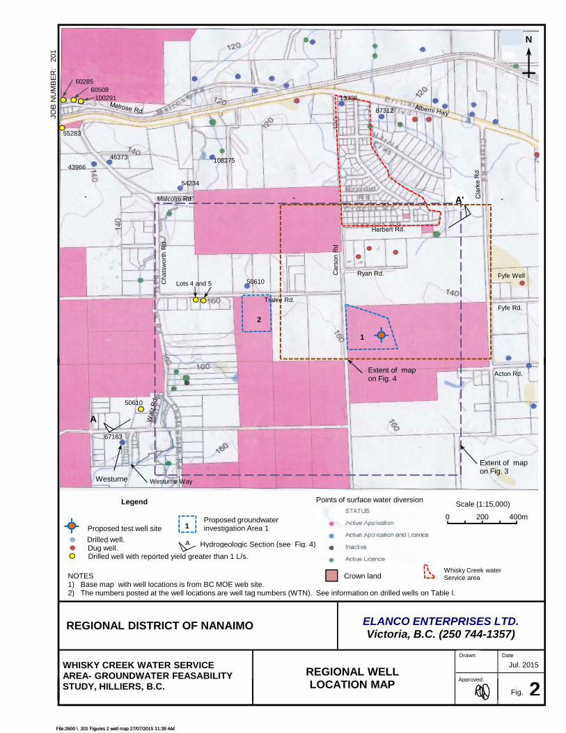
The irregular shaped Service Area is located south of the Alberni Highway (Hwy 4) and is accessed via Poplar Way. The area is located on undulating land that predominantly rises upwards towards the south. The Crocker Creek water intake is located at the east end of Herbert Street at an elevation of about 123 metres above mean sea level (m-asl) (see Figs. 1 and 2).
The Service Area is drained on both east and west sides by tributaries of Whisky Creek, Crocker Creek being one of them (see Fig. 1). As is indicated later in this report, the base flows in the major Whisky Creek tributaries are sustained by groundwater flowing from an unconfined aquifer located in the south and west of the Service Area.
Surficial Geology
The regional geology map indicates that the Service Area is underlain by marine and glaciomarine sediments (Unit 12a and 12c on Fig. 1). Unit 12a is comprised of sand and sandy gravel (see Photo 1). which are generally underlain by clay. Unit 12c is relatively thin (less than 2m thick) and comprises stony gravel, sand, silt, clay and gravelly loam. South and west of the Service Area there is an extensive glaciofluvial deposit. This deposit is comprised of sand and gravel, with lenses of glacial till. Unit 8 is in the form of hummocky (kame) knob-and-kettle ridged deposits, which were formed when glaciers melted in the area. Further south, there are kame terrace and kame delta deposits Unit 9a).
Water Wells
GW Solutions Inc. (2012) have provided information on the regional hydrogeology and higher yielding wells. There is only one record of a well located in the Service Area (see Well 13336 on Fig. 2.) This 15.2m deep well was constructed before 1950 and other than knowing the depth to bedrock (7.9m) there no other information on the well (see listing on Table II). As the

Regional District of Nanaimo Attention: Gerald St. Pierre, P. Eng, PMP -3- July 25, 2015t
Elanco Enterprises Ltd.
well was apparently never commissioned and given it is geological setting, it is unlikely that this well had a yield greater than about 0.3 litres per second (L/s)
In the greater area, locations of about 50 wells are indicated on the regional well map presented on Fig. 2, and. of these, eight are shallow dug wells. This inventory was based initially on well records listed in the BC Ministry of Environment’s wells (MOE) database and has since been supplemented by well logs provided by a local well drilling contractor (see wells on Fig. 3). This is likely still not a complete record of all wells in the area, as government reporting on well construction is voluntary in BC. A summary of depth, yield and elevation information on most of the documented wells is provided on Table II.
The results of this review led to the following observations:
• Of the 33 well records for drilled well summarized on Table II, none confirmed a “dry hole”.
• The estimated yields ranged from 0.01 to 3.8 (L/s). This compares with the 2.4L/s peak summer demand required for the Service Area.
• The median and average yields were respectively 0.6 and 1.0 L/s.
• The higher yields were all from wells constructed in the hummocky kame deposits (Unit 8 on Fig. 1)
• Well depths ranged from 4.3 to 110m, but the median was only 14m
• Median depths to static water level (SWL) ranged from 0.9m to 19.8m, and the median was 7.6m.
• Only eight wells encountered bedrock. In each case the record indicates it was shale bedrock.
A dug well located on a property on the south side of Fyfe Road was considered as a potential water supply for the Service Area (see location on Fig. 2) as it had high yield potential. However, when learned that this well is about 6m deep and is situated in an area where surface water is present, this well was not pump tested, as the water from this well clearly would be considered GWUDI.
Aquifers and Groundwater Flow Systems
As indicated earlier, the glaciofluvial deposits form the most productive aquifer in the area, and this helps sustain base flows in the many tributaries of Whisky Creek, including Crocker Creek.
Using lithologic information from selected well logs, two hydrogeologic sections were constructed. These are the southwest to northeast Section A-A’, presented on Fig. 5 and the east-west to Section B-B’, presented on Fig. 6. Both sections are drawn through hummocky kame deposits (Unit 8) which gradually thin out from about 30m in the southwest to about 2m in the north east. This moderately permeable sand and gravel unit is underlain by shale bedrock, as is confirmed by the few wells that have fully penetrated the unit. Most of the wells were drilled for domestic water supplies and there was no reason to fully penetrate the aquifer.

Regional District of Nanaimo Attention: Gerald St. Pierre, P. Eng, PMP -4- July 25, 2015t
Elanco Enterprises Ltd.
The western portion of Section B-B’ is constructed through wells drilled on each lot in a residential subdivision. As can be seen, the well yields ranged from 0.5 to 1.3 L/s, with the higher yields coming from the deeper two of the seven wells. The other two wells located along this section had progressively lower yields with increased distance to the east. This trend was taken into account when selecting a test well site for the Service Area.
The saturated thickness in the south and western areas of the two sections is about 10m and hydraulic gradients are about 0.015. Assuming an average aquifer hydraulic conductivity of 4 x 10⁻⁴ m/s the calculated flux is about 6 L/s/100m of aquifer width.
The approximate 150m width of the groundwater discharge zone that feeds Crocker Creek is indicated on Fig. 5. This suggests that the base flow in Crocker Creek will be about 9 L/s, which is well above the Service Area peak usage of 2.4 L/s.
Potential for Constructing a Water Supply Well to Supply the Service Area
The nearest potential groundwater development areas (Area 1 and Area 2) to the existing service intake are located southeast (up gradient) of the Crocker Creek discharge area indicated on Figs. 2, 3 and 7. As they are located on crown land (see Fig. 2), it is possible that the RDN can get permission to locate a well on the property. For example, access to a proposed test site (in Area 1) appears feasible if permission can be obtained to pass through privately owned land located west of the crown land (see access road on Fig 3 and Photo 2.
As the lithology and permeability of the sediments in this target area are likely quite variable, it is recommended that a test drilling program be carried out, and a budget for at least two test holes be considered. If groundwater investigation in the nearest area (see Area No. 1 on Fig. 2) does not prove to be viable, then consideration could be given to exploring for a water source in development Area No. 2, which is located further west on crown land.
As there is always degree of uncertainty when selecting a site for groundwater exploration, the use of geophysical techniques can sometimes be considered to reduce the risk. Consideration was given to recommending the use of resistivity imaging to profile the base of the aquifer. This technique involves profiling using instruments on the ground surface to pass an electrical current into the ground and monitoring responses, so that depths lithological boundaries can be estimated (see information in Appendix B). The estimated cost of running a resistivity survey is in the range $6,000 to $8,000. This compares with an estimated $3,000 cost for drilling casing to a depth of 25m and assessing the potential for completing the hole as a production well or for an additional cost of $2,500 completing the hole as a monitoring well. As the chance of successfully constructing a production well using, the first test hole is reasonably good, the use of geophysics is likely not warranted at this site.
Water Quality
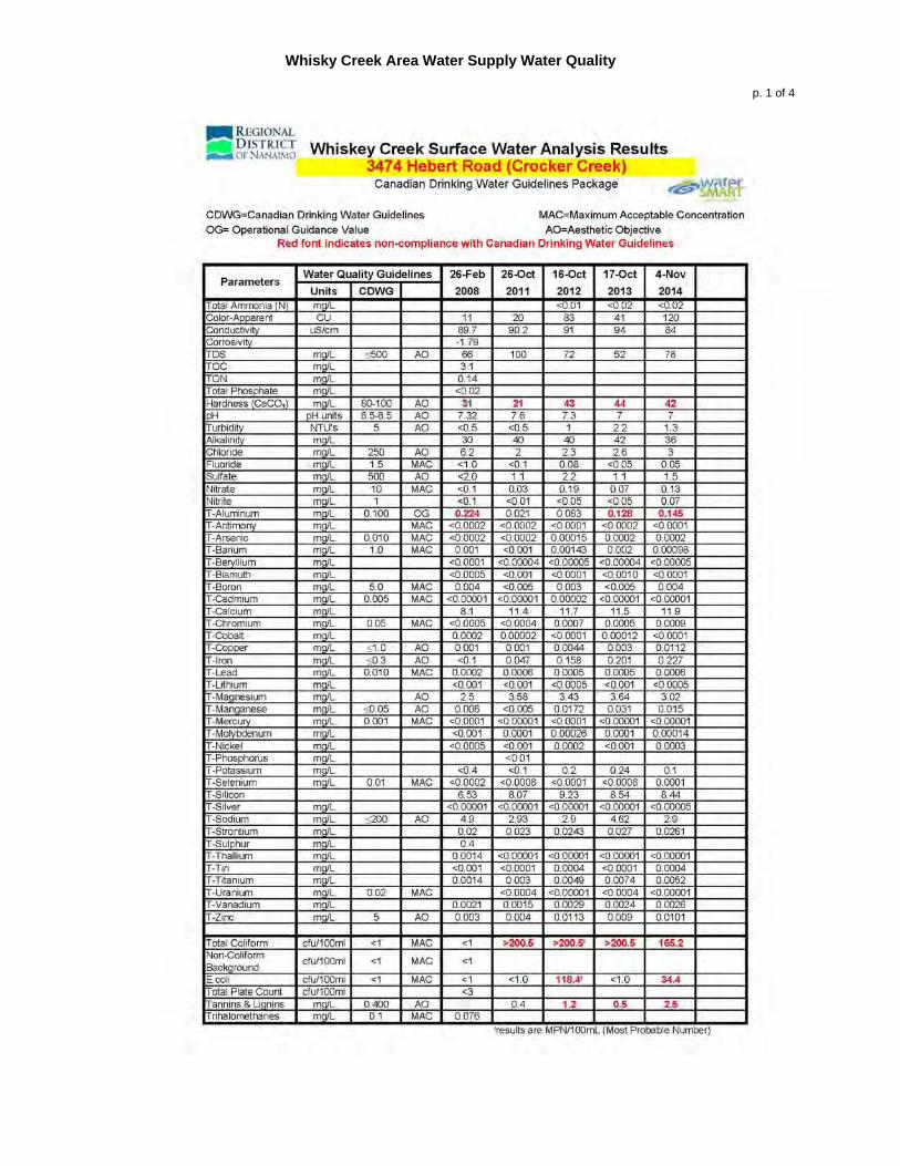
Inorganic water quality parameters in the analyses of Crocker Creek source water suggest that the water has a relatively low (100 mg/L) total dissolved solids concentration (TDS). Most of the inorganic parameters tested easily met Canadian Drinking Water Quality criteria (see data in Appendix C). The exception was aluminum for one sample, and total hardness (too low).
Regional District of Nanaimo Attention: Gerald St. Pierre, P. Eng, PMP -5- July 25, 2015t
Elanco Enterprises Ltd.
Similarly, water analyses for a community well located at Westurne Heights also indicate a low TDS and excellent water quality (see table in Appendix C). This suggests that a well located at the suggested development site will have a similar quality to these two sets of analyses.
Samples collected from a community well located on Melrose Terrace (see Fig. 2), had higher hardness concentrations and elevated iron and manganese concentrations. (see Appendix C) As this well is located in a hydrogeologically different area, this type of water quality is not anticipated at the proposed development site.
The estimated extent of the typical new production well capture zone is indicated on Fig. 7. In this example, the capture zone is currently undeveloped, and as there is likely a significant thickness of unsaturated sediments above the water table, the chance of the well being contaminated is relatively remote.
The water pumped from the well will not be considered groundwater under the direct influence of surface water (GWUDI).
Summary and Conclusions
1. Glaciofluvial aquifer located south east of the current Service area water intake has the potential for supplying the community needs from one or possibly two wells located on Crown land..
2. The nearest proposed development site is located approximately 0.5 Km from the existing water intake and is located on crown land. Routing for a potential pipeline could either follow a road right of way or have an easement to pass directly through privately owned land.
3. There is a relatively high chance of developing a water source capable of yielding up to 2.4 L/s from one well, and an even higher chance from two wells.
4. The water pumped from the proposed development site will very likely meet the Canadian Drinking Water Quality standards for all parameters.
Limitations.
This investigation has been conducted using a standard of care consistent with that expected of scientific and engineering professionals undertaking similar work under similar conditions in B.C. No warranty is expressed or implied.
I trust that this is sufficient for you present purposes.
Yours truly,
Elanco Enterprises Ltd.
R. Allan Dakin, FEC, P. Eng. Senior Groundwater Engineer

References
GW Solutions Inc. August 2012. Whisky Creek Groundwater Supply Assessment. Report prepared for the Regional District of Nanaimo, 11pp
Koers & Associates Engineering Ltd, September 2014. Whisky Creek Service Area – Water Treatment Options. Report prepared for the Regional District of Nanaimo. 23pp.
Koers & Associates Engineering Ltd, January 2014. Westurne Heights Water System Assessment. Report prepared for the Regional District of Nanaimo.
Elanco Enterprises Ltd.

Elanco Enterprises Ltd.
Photographs

Photo. 1 Exposed sands and gravel – typical of the type found in the test well area.
Test Well Site
Photo. 2 Recommended site for a test well on Crown Land Property.
Elanco Enterprises Ltd.

Elanco Enterprises Ltd.
Tables
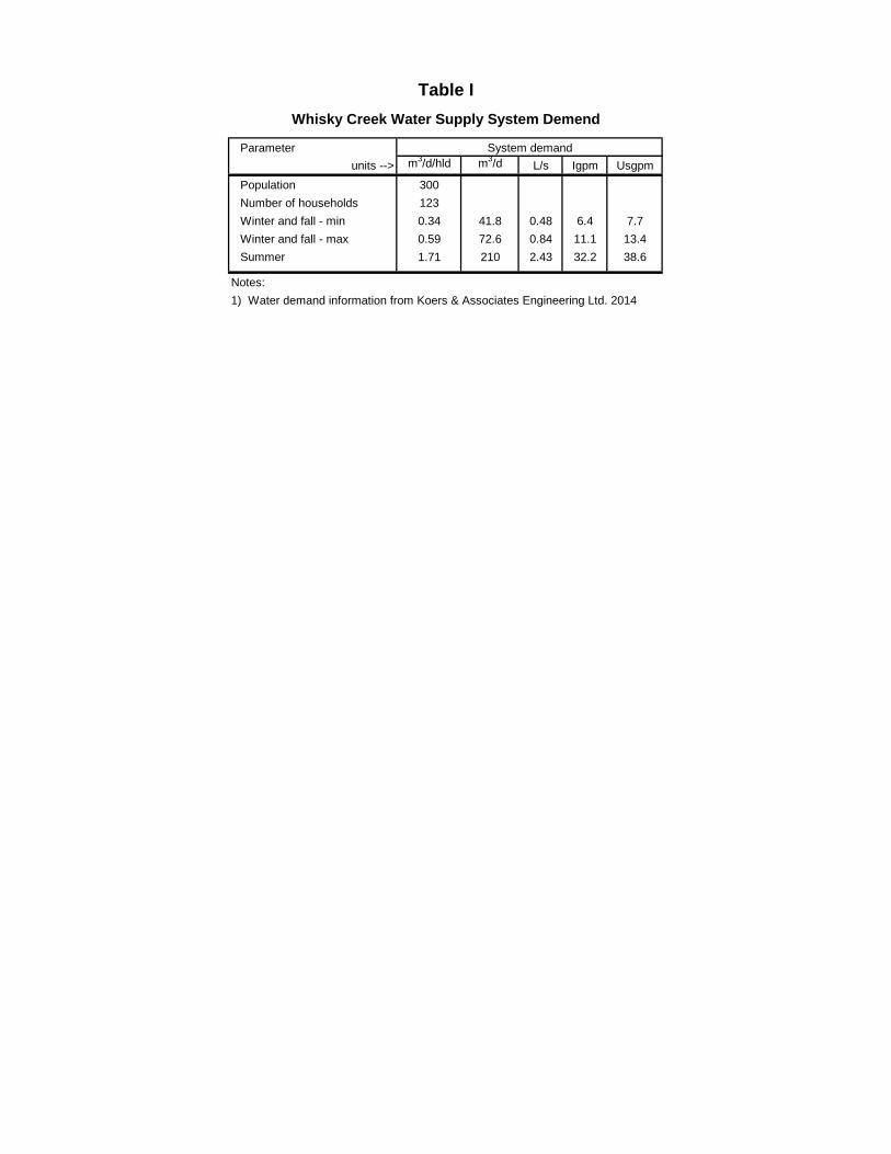
Parameterunits --> m3/d/hld m3/d L/s Igpm Usgpm
Population 300Number of households 123Winter and fall - min 0.34 41.8 0.48 6.4 7.7Winter and fall - max 0.59 72.6 0.84 11.1 13.4Summer 1.71 210 2.43 32.2 38.6
Notes:1) Water demand information from Koers & Associates Engineering Ltd. 2014
System demand
Table IWhisky Creek Water Supply System Demend

Table IIInformation on local area water wells
p. 2 of 3
Address WTN Depth (metres) to: Elevation (m-asl) Yield
Year Type Top of Aquifer SWL Water
StrikeBottom of
AquiferBedrock surface
Bottom of Hole Ground Top of
Aquifer SWL Water Strike
Bottom of Aquifer
Bedrock surface
Bottom of Hole L/s
Albernei Highway - No. 4 13051 <1950 na 7.3 8.8 7.3 8.8 8.8 9.4 140 132.7 131.2 132.7 131.2 131.2 130.6 na
Burbank Road 13184 <1950 na na 9.1 9.1 na na 10.4 130 na 120.9 120.9 na na 119.6 na
Albernei Highway - No. 4 13217 <1950 na na 9.1 9.1 na na 10.4 129 na 119.9 119.9 na na 118.6 na
Albernei Highway - No. 4 13270 <1950 D4 na 10.1 na na na 10.7 138 na 127.9 na na na 127.3 na
Albernei Highway - No. 4 13306 <1950 D3 na 0.9 na na na 4.3 119 na 118.1 na na na 114.7 na
Albernei Highway - No. 4 13313 <1950 D4 na 4.3 na na na 4.9 119 na 114.7 na na na 114.1 na
Albernei Highway - No. 4 13336 <1950 D8 na na na 7.9 7.9 15.2 120 na na na 112.1 112.1 104.8 na
Albernei Highway - No. 4 13363 <1950 D4 na 10.1 na na na 10.7 120 na 109.9 na na na 109.3 na
Albernei Highway - No. 4 13365 <1950 na 6.1 7.0 na na na 7.9 128 121.9 121.0 na na na 120.1 na
Melrose Road 27360 1972 Dr na 6.1 12.2 na 11.3 30.5 115 na 108.9 102.8 na 103.7 84.5 0.9
Melrose Road 43043 1979 D6 na 4.6 na na 15.2 68.6 120 na 115.4 na na 104.8 51.4 0.1
907 Chatsworth Rd (Big Country Auto) 43966 1979 D6 na 6.1 6.1 na na 18.3 144 na 137.9 137.9 na na 125.7 0.6
Albernei Highway - No. 4 44700 1980 D6 na 11.3 na na na 17.4 130 na 118.7 na na na 112.6 0.3
Chatsworth Road 46373 1980 D6 15.2 15.2 18.3 na na 26.8 144 128.8 128.8 125.7 na na 117.2 0.4
3681 Tralee Road 50473 1982 D6 6.1 6.1 6.1 13.7 13.7 13.7 152 145.9 145.9 145.9 138.3 138.3 138.3 0.3
Chatsworth Rd (1191 Waltz Road) 506i0 1982 D6 8.8 na 8.8 na na 11.9 170 161.2 na 161.2 na na 158.1 1.9
Malcolm Road @ Chatsworth 54234 1984 D6 na 9.1 na na na 18.3 146 na 136.9 na na na 127.7 0.3
Construction
@
Albernei Highway - Service Stn 55283 1985 D6 4.6 3.7 4.6 na na 13.7 135 130.4 131.3 130.4 na na 121.3 2.2
Melrose Road (iron issue) 60285 1993 D6 5.5 2.3 3.0 14.3 na 16.8 135 129.5 132.7 132.0 120.7 na 118.2 3.8
Melrose Road 60508 1994 D6 18.9 18.9 19.8 29.0 33.2 33.2 137 118.1 118.1 117.2 108.0 103.8 103.8 2.2
Albernei Highway - No. 4 82056 na D6 na na na na 9.1 103.6 114 na na na na 104.9 10.4 0.01
3514 Brittain Boulevard 87312 1983 D6 na 1.5 na na 7.9 109.7 113 na 111.5 na na 105.1 3.3 na
Melrose Road - RDN utility 93890 na D6 na 19.2 na 26.2 na 29.3 140 na 120.8 na 113.8 na 110.7 na
Melrose Road 100291 1994 Dr 10.7 4.3 10.7 13.4 na 14.3 133 122.3 128.7 122.3 119.6 na 118.7 1.9
3679 Melrose Road 110000 2014 D6 8.5 7.9 8.5 14.0 na 14.6 120 111.5 112.1 111.5 106.0 na 105.4 0.4
File: \ 201 Tables 2 Well summary 27/07/2015 11:39 AM

Table IIInformation on local area water wells
p. 3 of 3
Address WTN Depth (metres) to: Elevation (m-asl) Yield
Year Type Top of Aquifer SWL Water
StrikeBottom of
AquiferBedrock surface
Bottom of Hole Ground Top of
Aquifer SWL Water Strike
Bottom of Aquifer
Bedrock surface
Bottom of Hole L/s
Construction
Tralee Road - Lot 1 na 1996 D6 5.5 7.0 5.5 10.5 na 11.6 160 154.5 153.0 154.5 149.5 na 148.4 0.6
Tralee Road - Lot 2 na 1996 D6 7.3 5.0 7.3 13.6 na 14.0 161 153.7 156.0 153.7 147.4 na 147.0 0.5
Tralee Road - Lot 3 na 1996 D6 6.7 4.3 7.3 12.0 na 12.2 161 154.3 156.7 153.7 149.0 na 148.8 0.4
Tralee Road - Lot 4 na 1996 D6 9.8 9.4 9.8 19.7 na 19.7 160 150.2 150.6 150.2 140.3 na 140.3 1.3
Tralee Road - Lot 5 na 1996 D6 12.8 8.8 12.8 17.1 na 17.1 160 147.2 151.2 147.2 142.9 na 142.9 1.3
Tralee Road - Lot 6 na 1996 D6 9.4 7.6 9.4 13.7 na 13.7 159 149.6 151.4 149.6 145.3 na 145.3 0.6
Tralee Road - Lot 7 na 1996 D6 7.6 8.8 8.5 10.2 na 11.4 159 151.4 150.2 150.5 148.8 na 147.6 0.6
Tralee Road - Lot A na 2003 D6 7.9 na 8.5 11.0 na 11.0 155 147.1 na 146.5 144.0 na 144.0 0.6
Minimum 4.6 0.9 3.0 7.9 7.9 4.3 113 111.5 109 102.8 106.0 3.3 0.01 Median 7.8 7.6 8.5 13.6 10.2 14.0 137 146.5 129 137.9 139.3 119.6 0.6 Average 8.8 7.8 9.2 14.7 13.4 22.3 138 139.5 130 136.5 132.3 116.1 1.0 Maximum 18.9 19.2 19.8 29.0 33.2 109.7 170 161.2 157 161.2 149.5 158.1 3.8
otes:1) Data based on logs available on the BC Ministry of Environment wells data base and other sources.2) See locations of wells on Figs. 2 and 3 Well Construction Type3) Ground elevations estimated from Google Earth mapping. na = No informationSWL = static water level recorded soon after well construction Dr = drill hole diam not indicated (likely 6-inch diam)WTN = Well tag number assigned by BC MOE. D4, D6, D8 = Drilled hole with 4, 6 and 8-inch diameter.
DRAFT
File: \ 201 Tables 2 Well summary 27/07/2015 11:39 AM

Figures
Elanco Enterprises Ltd.

JOB
NU
MB
ER
: 2
01
N
Cla
rk
Cha
tsw
orth
Fyfe
Tralee
Gilb
ert
Acton
Malcolm
Kriscoll
A'
Crocker
1Fig.SURFICIAL GEOLOGY MAP
Jul. 2015Date
Approved:
Drawn:
REGIONAL DISTRICT OF NANAIMO
WHISKY CREEK WATER SERVICE AREA- GROUNDWATER FEASABILITY STUDY, HILLIERS, B.C.
ELANCO ENTERPRISES LTD.Victoria, B.C. (250 744-1357)
Scale (1:30,000) 0 400 800mLegend
NOTES1) Adapted from Geological Survey of Canada 1:63,000 scale Maps No.1111A & 1112A2) See Hydrogeological Section A-A' on Fig.4A
Crocker Creek water supply source
Whisky Creek water Service area
Well with reported >1 L/s yield.
A
1Fig.SURFICIAL GEOLOGY MAP Approved:AREA GROUNDWATER FEASABILITY
STUDY, HILLIERS, B.C.
File:2600 \ 201 Figures 1 Surficial Geology 27/07/2015 11:39 AM
JOB
NU
MB
ER
: 2
01
A'
N
50610
60285
10029160508
Tralee Rd.
Cha
tsw
orth
Rd.
13336
87312
54234
4637343966
108275
Malcolm Rd.
Ryan Rd.Car
son
Rd
55283
Lots 4 and 5
Fyfe Rd.
Fyfe Well
1
2
File:2600 \ 201 Figures 2 well map 27/07/2015 11:39 AM
2Fig.
REGIONAL WELL LOCATION MAP
Jul. 2015Date
Approved:
Drawn:
REGIONAL DISTRICT OF NANAIMO
WHISKY CREEK WATER SERVICE AREA- GROUNDWATER FEASABILITY STUDY, HILLIERS, B.C.
ELANCO ENTERPRISES LTD.Victoria, B.C. (250 744-1357)
Scale (1:15,000)
0 200 400m
Extent of map on Fig. 4
Legend
A
50610
67163
Westurne Westurne Way
NOTES1) Base map with well locations is from BC MOE web site.2) The numbers posted at the well locations are well tag numbers (WTN). See information on drilled wells on Table I.
Drilled well.Dug well.Drilled well with reported yield greater than 1 L/s.
Acton Rd.
Proposed test well site
Extent of map on Fig. 3
Proposed groundwater investigation Area 11
Crown land
A Hydrogeologic Section (see Fig. 4)
Whisky Creek water Service area
Points of surface water diversion
2Fig.LOCATION MAP Approved:AREA GROUNDWATER FEASABILITY
STUDY, HILLIERS, B.C.
File:2600 \ 201 Figures 2 well map 27/07/2015 11:39 AM

JOB
NU
MB
ER
: 2
01
N
BB'
C
C'
1 2 3 4 5 6 7
A50610
Potential first test well site
Whisky Creek surface water intake
Area 1
Area 2
Potential access trail for test drilling rig.
Tralee Rd.
Car
son
Rd
Ryan Rd.
Cha
tsw
orth
Rd.
3Fig.MAP OF STUDY AREA
Jul. 2015Date
Approved:
Drawn:
REGIONAL DISTRICT OF NANAIMO
WHISKY CREEK WATER SERVICE AREA- GROUNDWATER FEASABILITY STUDY, HILLIERS, B.C.
ELANCO ENTERPRISES LTD.Victoria, B.C. (250 744-1357)
Scale (1:10,000)
0 200 400m
NOTES1) With the exception of one well (WTN 50610) none of these wells are located on the MOE web based map .
See Note. 1
Legend
B Hydrogeologic Section (see Figs 5 and 7)
Drilled well.Dug well.
Drilled well with reported yield greater than 1 L/s.
Points of surface water diversion
Proposed groundwater investigation Area 11
3Fig.MAP OF STUDY AREA Approved:AREA GROUNDWATER FEASABILITY
STUDY, HILLIERS, B.C.
File:2600 \ 201 Figures 3 Tralee map 27/07/2015 11:39 AM

Estimated flow in the section = 0.05 L/s/m
JOB
NU
MB
ER
: 2
01E
leva
tion
(m-a
sl)
170
SWA
160
150
140
130
5047
3
5061
0
?
Shale Bedrock
Estimated level
NEA'
120
?
?
?
?
Crocker Creek
Sand and Gravel
Chatsworth Rd.
Tralee Rd.
5.2 L/s/100mGradient = 0.013
Thickness = 10 mHydraulic conductivity = 0.0004 m/s
4Fig.HYDROGEOLOGICAL SECTION
A - A'
Jul. 2015Date
Approved:
Drawn:
ELANCO ENTERPRISES LTD.Victoria, B.C. (250 744-1357)
NOTES1) See location of section on Figs. 2 and 3 and information on wells on Table I.
Legend
Dense silty sand and gravel (till like)
Interpreted groundwater flow direction
In plane of section
Into section
Out of section
Horizontal Scale (1:15,000) 0 200 400m
Sand and gravel Water level at time of construction
Downward infiltrating groundwater
REGIONAL DISTRICT OF NANAIMO
WHISKY CREEK WATER SERVICE AREA- GROUNDWATER FEASABILITY STUDY, HILLIERS, B.C.
Vertical exaggeration = 30
Sand and gravel aquifer
Spring / groundwater discharge area.
4Fig.A - A'Approved:AREA GROUNDWATER FEASABILITY
STUDY, HILLIERS, B.C.
File:2600 \ 201 Figures 4 Sect A 27/07/2015 11:39 AM
f 0 06 / /
JOB
NU
MB
ER
: 2
01Driller's well yield estimate.
EastWest
B B'165
155
145
135
140
150
160
Ele
vatio
n (m
-asl
)
?
50473Offset50m N
Lot 1 Lot 2 Lot 3 Lot 4 Lot 5Lot 6
Lot 7
Lot A
0.6 L/s
0.5 L/s
0.4 L/s
1.3 L/s
1.3L/s
0.6 L/s
0.6 L/s
0.6 L/s
0.3L/s
Estimated flow in the section = 0.06 L/s/m6.4 L/s/100m
Gradient = 0.016Thickness = 10 m
Hydraulic conductivity = 0.0004 m/s
Interpreted groundwater flow direction
In plane of section
Into section
Out of section
5Fig.
HYDROGEOLOGICALSECTION B - B'
Jul. 2015Date
Approved:
Drawn:
ELANCO ENTERPRISES LTD.Victoria, B.C. (250 744-1357)
Horiz. scale (1:5,000) 0 80 160m
SWL
NOTES1) See location of section on Fig. 3 and summary of information on wells in Table II.2) SWL = static water level at the time of construction.
Permeable sediments (Sand and gravel, with some silt zones)
Legend
Interpreted water table
Vertical exaggeration = 16.7
Low permeability (till like) sediments
Clay and dense silt
Peat.
Shale bedrock
Well screen
REGIONAL DISTRICT OF NANAIMO
WHISKY CREEK WATER SERVICE AREA- GROUNDWATER FEASABILITY STUDY, HILLIERS, B.C. 5Fig.SECTION B - B' Approved:STUDY, HILLIERS, B.C.
File:2600 \ 201 Figures 5 Sect B 27/07/2015 11:39 AM

JOB
NU
MB
ER
: 2
01
Ryan Rd.
Tralee Rd.
C'
C
Area 1
6Fig.
MAP OF AREA SHOWING POTENTIAL TEST WELL
Jul. 2015Date
Approved:
Drawn:
REGIONAL DISTRICT OF NANAIMO
WHISKY CREEK WATER SERVICE AREA- GROUNDWATER FEASABILITY STUDY, HILLIERS, B.C.
ELANCO ENTERPRISES LTD.Victoria, B.C. (250 744-1357)
Scale (1:7,000) 0 100 200m
NOTES1) Base map from Google Earth 2015 view.
Legend
Proposed test well site
C Hydrogeologic Section (see Fig 7)
Groundwater discharge area that supplies Crocker Creek.
Whisky Creek surface water intake
Potential access trail for test drilling rig.
Proposed groundwater investigation Area 11
6Fig.POTENTIAL TEST WELL Approved:AREA GROUNDWATER FEASABILITY
STUDY, HILLIERS, B.C.
File:2600 \ 201 Figures 6 Google map 27/07/2015 11:39 AM

JOB
NU
MB
ER
: 2
01E
leva
tion
(m-a
sl)
New Water Well160
SWC
150
140
130
120
Shale Bedrock
NEC'
110
?
Crocker Creek
Sand and Gravel
Whisky Creek water
Crown Land Development Area 1
7Fig.HYDROGEOLOGICAL SECTION
C - C'
May. 2015Date
Approved:
Drawn:
ELANCO ENTERPRISES LTD.Victoria, B.C. (250 744-1357)
NOTES1) See location of section on Figs. 2 and 3 and information on wells on Table I.
Sand and gravel
Legend
Dense silty sand and gravel (till like)
Interpreted groundwater flow direction
In plane of section
Into section
Out of section
Interpreted aquifer unit
Water level at time of construction
Downward infiltrating groundwater
REGIONAL DISTRICT OF NANAIMO
WHISKY CREEK WATER SERVICE AREA- GROUNDWATER FEASABILITY STUDY, HILLIERS, B.C.
Scale (1:7,000) 0 100 200m
Vertical exaggeration = 14
Spring / groundwater discharge area.
7Fig.C - C'Approved:AREA GROUNDWATER FEASABILITY
STUDY, HILLIERS, B.C.
File:2600 \ 201 Figures 7 Sect C 27/07/2015 11:39 AM

Appendix A
Study Terms of Reference
Elanco Enterprises Ltd.


Appendix B
Information on Geophysical Systems that could be used for Groundwater Source Exploration
Elanco Enterprises Ltd.


Elanco Enterprises Ltd.
Appendix C
Water Quality from Representative Water Supply Systems.
Whisky Creek Area Water Supply Water Quality
p. 1 of 4

Whisky Creek Area Water Supply Water Quality
p. 2 of 4

Whisky Creek Area Water Supply Water Quality
p. 3 of 4
Westurne Community Water Well (WTN 67163)

Whisky Creek Area Water Supply Water Quality
p. 4 of 4


![A.I. Enterprises Ltd. and A.I. Enterprises Ltd. et …...[2014] 1 R.C.S. A.I. ENTERPRISES c. BRAM ENTERPRISES 177 A.I. Enterprises Ltd. et Alan Schelew Appelants c. Bram Enterprises](https://static.fdocuments.in/doc/165x107/5e918dac94e60f42b949e30a/ai-enterprises-ltd-and-ai-enterprises-ltd-et-2014-1-rcs-ai-enterprises.jpg)
