El Niño Patterns and Sediment Flux to the Deep Sea
49
1 Influence of millennialscale El Niño pa4erns on sediment delivery from land to the deep sea Insights from the Holocene Santa Monica Basin, CA Brian Romans Virginia Tech Geosciences NASA
-
Upload
brian-romans -
Category
Education
-
view
4.322 -
download
0
Transcript of El Niño Patterns and Sediment Flux to the Deep Sea

1
Influence of millennial-‐scale El Niño pa4erns on sediment delivery from land to the deep sea
Insights from the Holocene Santa Monica Basin, CA
Brian Romans Virginia Tech Geosciences
NASA
source
sink
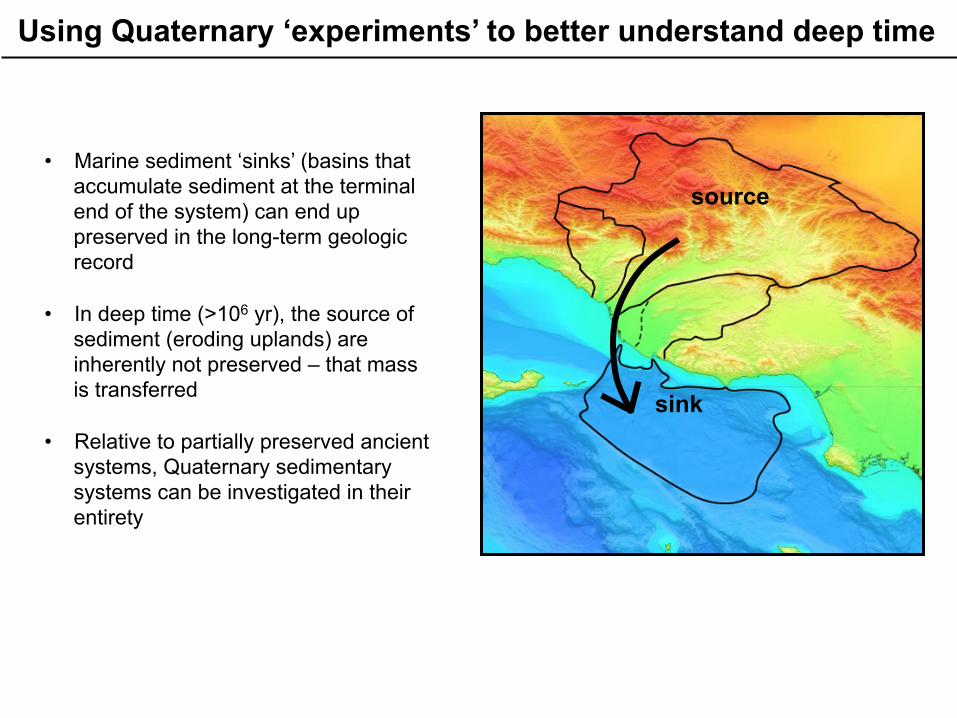
• Marine sediment ‘sinks’ (basins that accumulate sediment at the terminal end of the system) can end up preserved in the long-term geologic record
• In deep time (>106 yr), the source of
sediment (eroding uplands) are inherently not preserved – that mass is transferred
• Relative to partially preserved ancient
systems, Quaternary sedimentary systems can be investigated in their entirety
Using Quaternary ‘experiments’ to better understand deep time
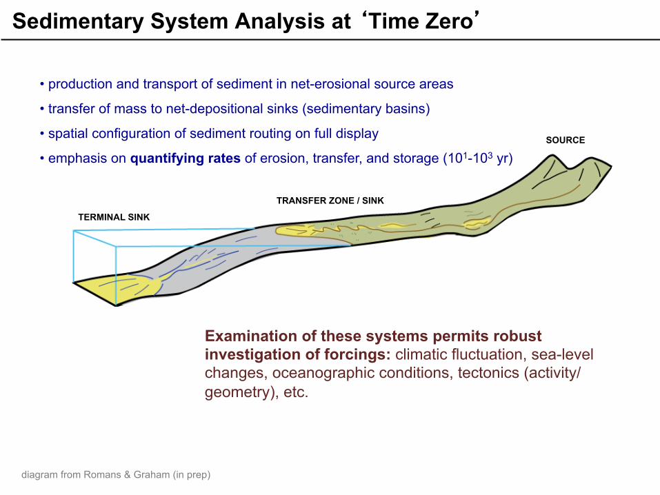
Sedimentary System Analysis at ‘Time Zero’
• production and transport of sediment in net-erosional source areas
• transfer of mass to net-depositional sinks (sedimentary basins)
• spatial configuration of sediment routing on full display
• emphasis on quantifying rates of erosion, transfer, and storage (101-103 yr) SOURCE
TRANSFER ZONE / SINK
TERMINAL SINK
Examination of these systems permits robust investigation of forcings: climatic fluctuation, sea-level changes, oceanographic conditions, tectonics (activity/geometry), etc.
diagram from Romans & Graham (in prep)
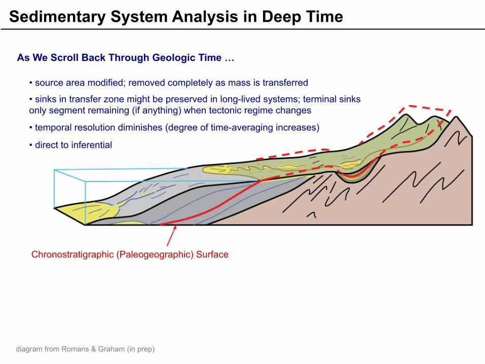
Sedimentary System Analysis in Deep Time
As We Scroll Back Through Geologic Time …
• source area modified; removed completely as mass is transferred
• sinks in transfer zone might be preserved in long-lived systems; terminal sinks only segment remaining (if anything) when tectonic regime changes
• temporal resolution diminishes (degree of time-averaging increases)
• direct to inferential
Chronostratigraphic (Paleogeographic) Surface
diagram from Romans & Graham (in prep)
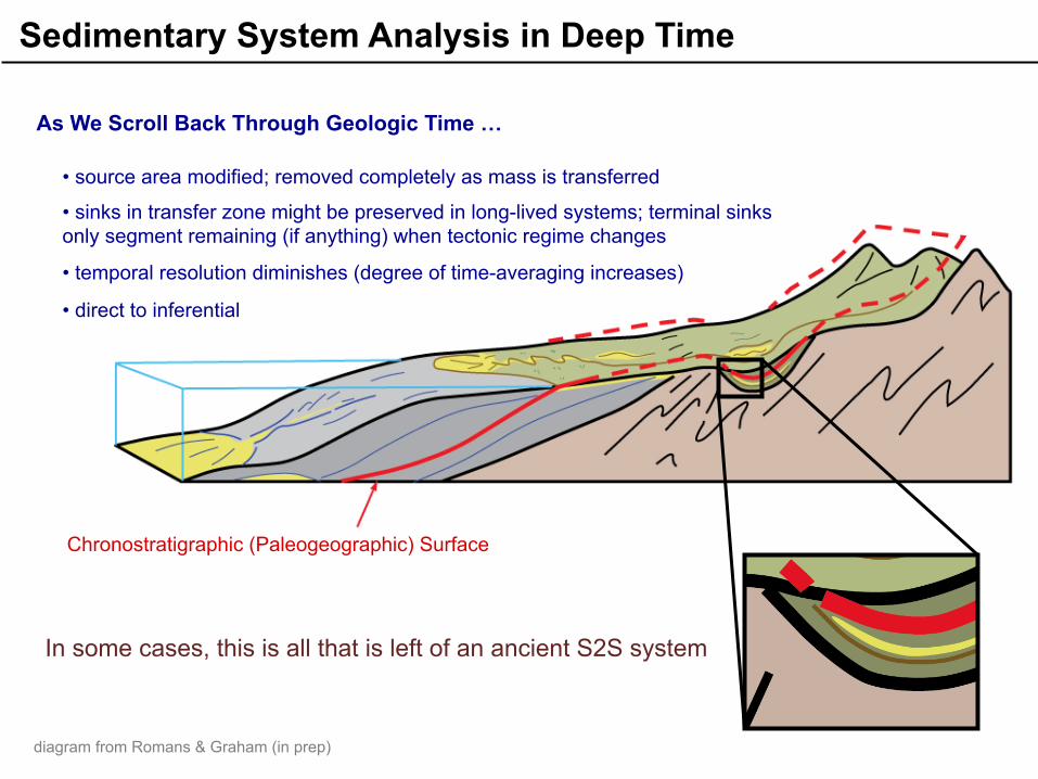
As We Scroll Back Through Geologic Time …
In some cases, this is all that is left of an ancient S2S system
Chronostratigraphic (Paleogeographic) Surface
• source area modified; removed completely as mass is transferred
• sinks in transfer zone might be preserved in long-lived systems; terminal sinks only segment remaining (if anything) when tectonic regime changes
• temporal resolution diminishes (degree of time-averaging increases)
• direct to inferential
Sedimentary System Analysis in Deep Time
diagram from Romans & Graham (in prep)

Thin- and medium-bedded turbidites interbedded with siltstone, Paleocene German Rancho Fm., northern California coast (photo taken by Brian Romans)
I’m a geologist … I want to know what controls these patterns

Meter-scale turbidite beds in the Upper Cretaceous Tres Pasos Formation, southern Chile (photo taken by Brian Romans)
I’m a geologist … I want to know what controls these patterns
Controls on stratigraphic patterns are divided into two general categories: Allogenic
Autogenic
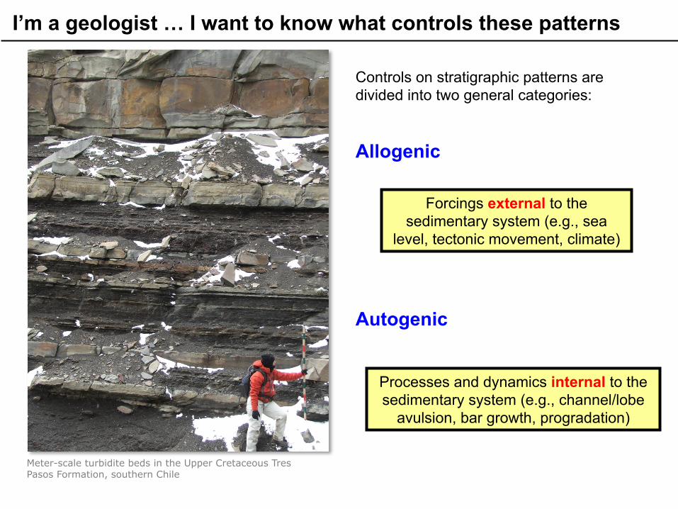
Meter-scale turbidite beds in the Upper Cretaceous Tres Pasos Formation, southern Chile
I’m a geologist … I want to know what controls these patterns
Controls on stratigraphic patterns are divided into two general categories: Allogenic
Autogenic
Forcings external to the sedimentary system (e.g., sea
level, tectonic movement, climate)
Processes and dynamics internal to the sedimentary system (e.g., channel/lobe
avulsion, bar growth, progradation)

Meter-scale turbidite beds in the Upper Cretaceous Tres Pasos Formation, southern Chile
I’m a geologist … I want to know what controls these patterns
Controls on stratigraphic patterns are divided into two general categories: Allogenic vs. Autogenic?
One way to approach this problem is to carefully investigate ‘modern’ systems where the controls are much better constrained

Why study sediment-routing systems in the California Borderland?
§ basins are small à data coverage of an individual system is good
§ relatively sand-rich submarine fan systems adjacent to nearby and uplifting sediment sources
§ External forcings such as climatic fluctuations, sea level, and tectonism is well constrained
NOAA
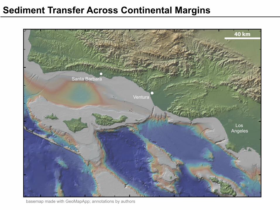
Sediment Transfer Across Continental Margins
Los Angeles
Santa Barbara
Ventura
basemap made with GeoMapApp; annotations by authors

source
sink
sink
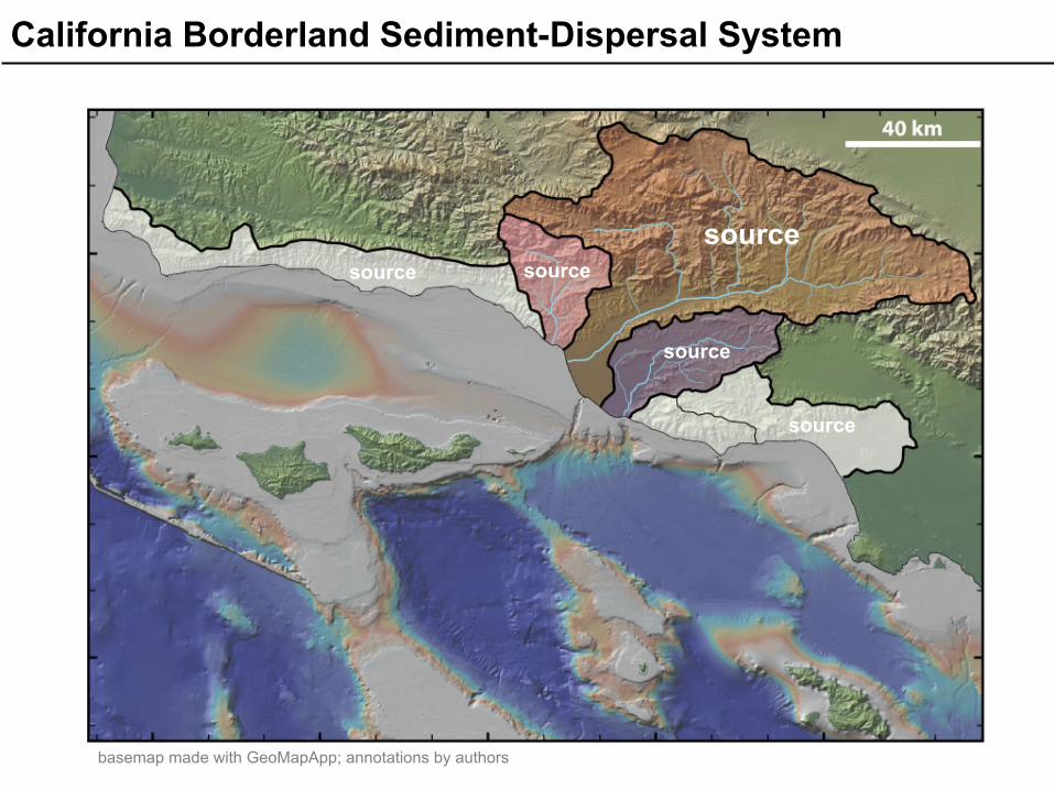
California Borderland Sediment-Dispersal System
basemap made with GeoMapApp; annotations by authors

California Borderland Sediment-Dispersal System
source
sink
sink sink sink
source source
source
sink
sink
basemap made with GeoMapApp; annotations by authors
source source
source
source
source
California Borderland Sediment-Dispersal System
basemap made with GeoMapApp; annotations by authors

sink
sink
sink
sink
sink
sink
sink
source source
source
source
source
California Borderland Sediment-Dispersal System
basemap made with GeoMapApp; annotations by authors

sink
sink
sink
sink
sink
sink
sink
source source
source
source
source
California Borderland Sediment-Dispersal System
basemap made with GeoMapApp; annotations by authors

A single watershed feeds multiple sinks and one sink receives material from multiple watersheds
California Borderland Sediment-Dispersal System
basemap made with GeoMapApp; annotations by authors

The Santa Barbara littoral cell moves coarse-grained sediment laterally across the margin
California Borderland Sediment-Dispersal System
basemap made with GeoMapApp; annotations by authors

Routing of Coarse-Grained Sediment (sand + gravel)
Santa Clara River
Calleguas Creek
Hueneme Canyon

Vast majority of post-Last Glacial Maximum sand delivered to coast ends up in Santa Monica Basin
California Borderland Sediment-Dispersal System
basemap made with GeoMapApp; annotations by authors
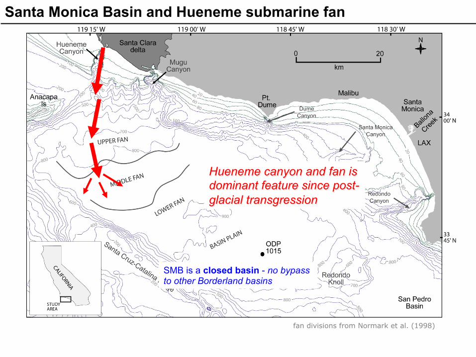
Santa Monica Basin and Hueneme submarine fan
Hueneme canyon and fan is dominant feature since post-glacial transgression
SMB is a closed basin - no bypass to other Borderland basins
fan divisions from Normark et al. (1998)

Santa Monica Basin and Hueneme submarine fan
fan divisions from Normark et al. (1998)
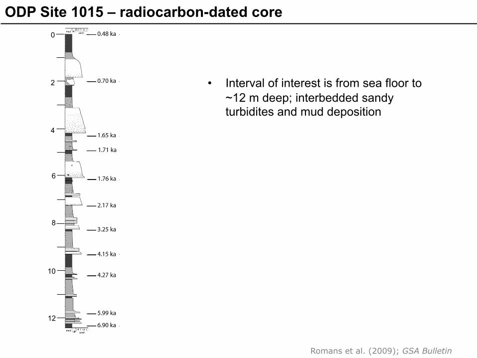
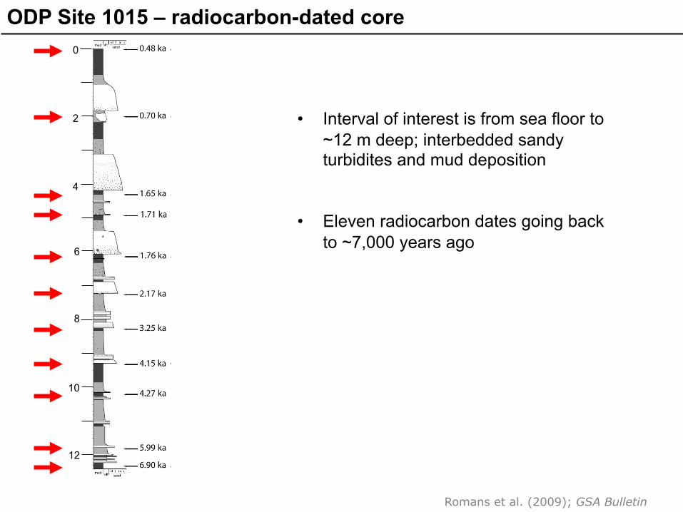
ODP Site 1015 – radiocarbon-dated core
• Interval of interest is from sea floor to ~12 m deep; interbedded sandy turbidites and mud deposition
0
2
4
6
8
10
12
Romans et al. (2009); GSA Bulletin
ODP Site 1015 – radiocarbon-dated core
• Interval of interest is from sea floor to ~12 m deep; interbedded sandy turbidites and mud deposition
• Eleven radiocarbon dates going back to ~7,000 years ago
0
2
4
6
8
10
12
Romans et al. (2009); GSA Bulletin

ODP Site 1015 – radiocarbon-dated core
• Interval of interest is from sea floor to ~12 m deep; interbedded sandy turbidites and mud deposition
• Eleven radiocarbon dates going back to ~7,000 years ago
• Tied to seismic-reflection data à five stratigraphic intervals mapped
1
2
3
4
5
0
2
4
6
8
10
12
Romans et al. (2009); GSA Bulletin
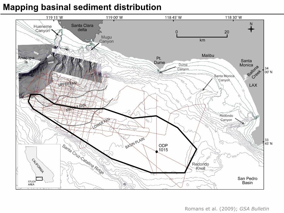
Mapping basinal sediment distribution
Romans et al. (2009); GSA Bulletin

Mapping basinal sediment distribution
area of sediment volume calculations
Romans et al. (2009); GSA Bulletin

Volumes and rates of basinal sedimentation
Over the past 7,000 years, the average sediment accumulation rate in Santa Monica Basin = 3.74 million tons/year
Romans et al. (2009); GSA Bulletin
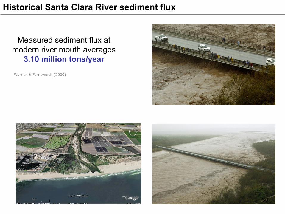
Historical Santa Clara River sediment flux
Measured sediment flux at modern river mouth averages
3.10 million tons/year
Warrick & Farnsworth (2009)
30

Historical Santa Clara River sediment flux
Measured sediment flux at modern river mouth averages
3.10 million tons/year
Warrick & Farnsworth (2009)
So, that’s an average over several millennia …what about the variability of flux at shorter time scales?
31
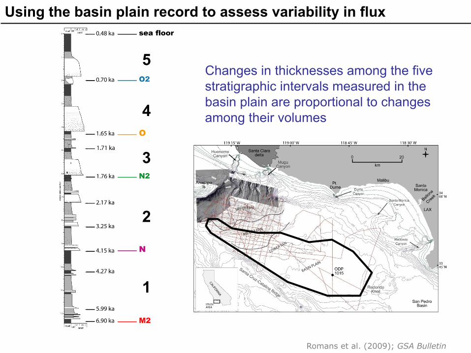
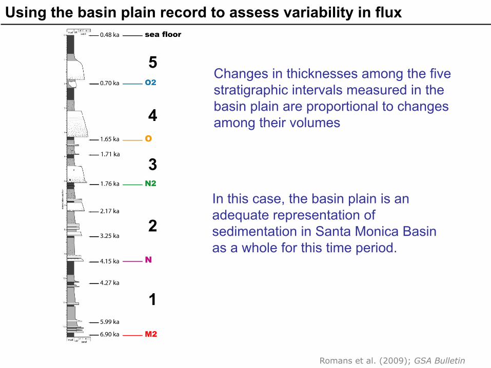
Using the basin plain record to assess variability in flux
1
2
3
4
5 Changes in thicknesses among the five stratigraphic intervals measured in the basin plain are proportional to changes among their volumes
Romans et al. (2009); GSA Bulletin
Using the basin plain record to assess variability in flux
1
2
3
4
5 Changes in thicknesses among the five stratigraphic intervals measured in the basin plain are proportional to changes among their volumes
In this case, the basin plain is an adequate representation of sedimentation in Santa Monica Basin as a whole for this time period.
Romans et al. (2009); GSA Bulletin

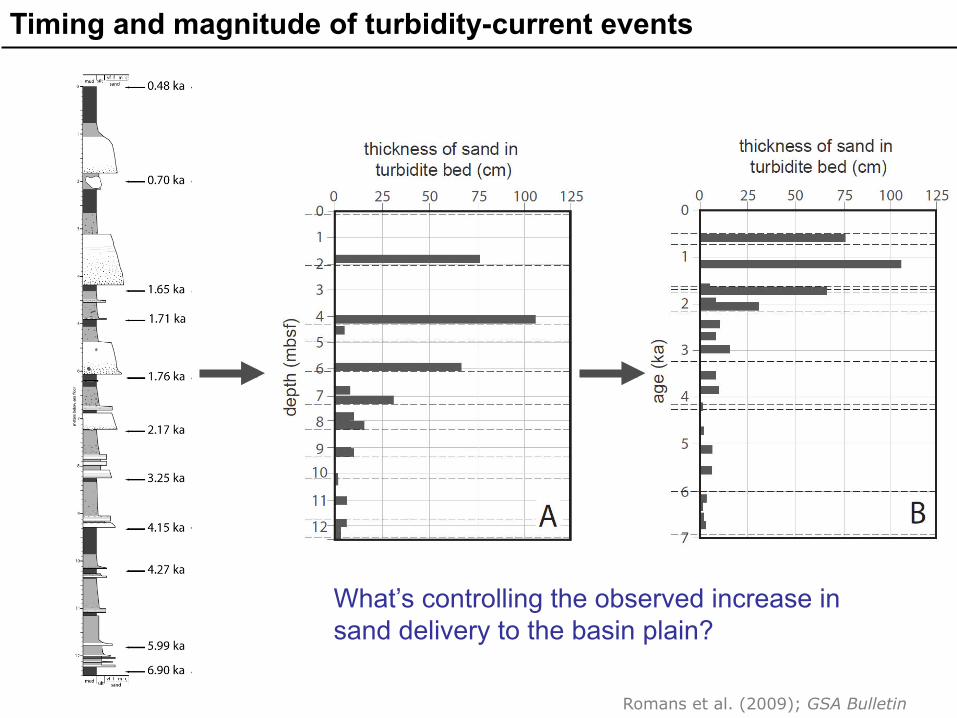
Timing and magnitude of turbidity-current events
Romans et al. (2009); GSA Bulletin
Timing and magnitude of turbidity-current events
What’s controlling the observed increase in sand delivery to the basin plain?
Romans et al. (2009); GSA Bulletin

Climate influence on sediment delivery to the deep sea
Moy et al. (2002)
Romans et al. (2009); GSA Bulletin
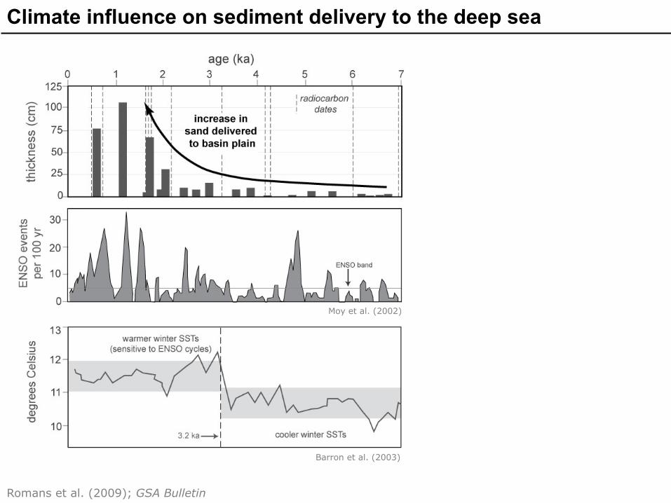
Climate influence on sediment delivery to the deep sea
Barron et al. (2003)
Moy et al. (2002)
Romans et al. (2009); GSA Bulletin

Climate influence on sediment delivery to the deep sea
Warrick & Farnsworth (2009)
Barron et al. (2003)
Moy et al. (2002)
Romans et al. (2009); GSA Bulletin

Relationship to Holocene seismicity
paleoseismologic compilation shows increased seismic activity of LA region faults ~1-3 ka
Dolan et al. (2007)
Romans et al. (2009); GSA Bulletin
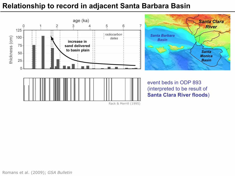
Relationship to record in adjacent Santa Barbara Basin
event beds in ODP 893 (interpreted to be result of Santa Clara River floods)
Santa Monica Basin
Santa Barbara Basin
Santa Clara River
Rack & Merrill (1995)
Romans et al. (2009); GSA Bulletin

Relationship to record in adjacent Santa Barbara Basin
event beds in ODP 893 (interpreted to be result of Santa Clara River floods)
Santa Monica Basin
Santa Barbara Basin
Santa Clara River
history of beach accretion and erosion along Santa Barbara coast
Sand eroded from Santa Barbara beaches very likely made its way into Santa Monica Basin via turbidity currents
Rack & Merrill (1995)
Masters (2006)
Romans et al. (2009); GSA Bulletin
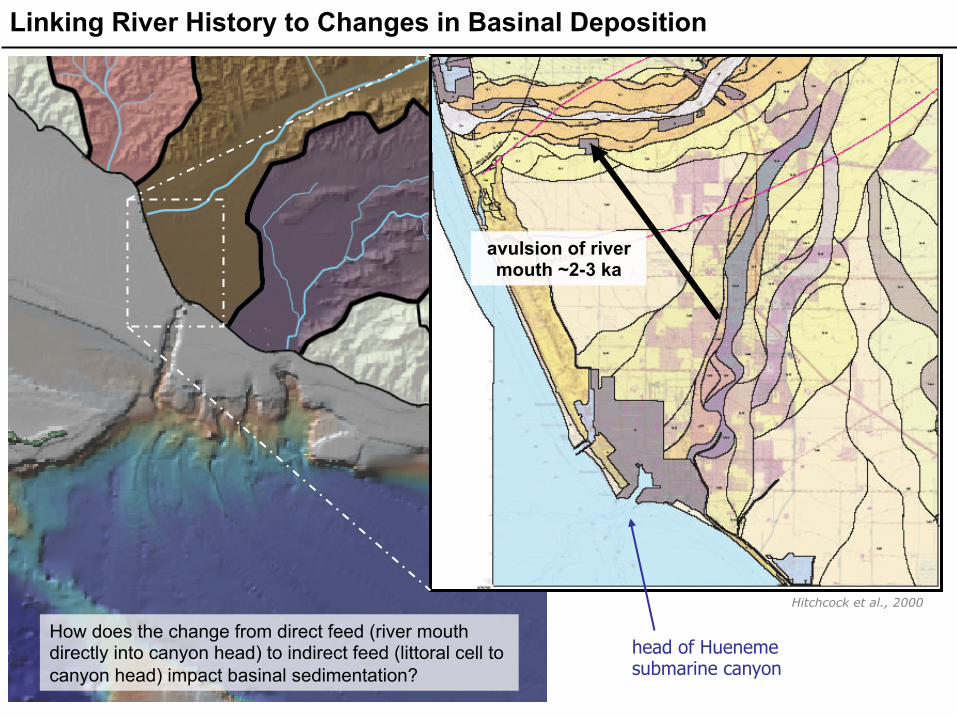
head of Hueneme submarine canyon
avulsion of river mouth ~2-3 ka
Hitchcock et al., 2000
Linking River History to Changes in Basinal Deposition
How does the change from direct feed (river mouth directly into canyon head) to indirect feed (littoral cell to canyon head) impact basinal sedimentation?

Shift in river recorded in basin plain stratigraphy?
direct river input
littoral cell input
Romans et al. (2009); GSA Bulletin

Interacting controls on delivery of sediment to the basin
• The timing and distribution of large turbidity currents are investigated.
Romans et al. (2009); GSA Bulletin

Interacting controls on delivery of sediment to the basin
• The timing and distribution of large turbidity currents are investigated.
• Increase in magnitude and frequency of ENSO cycles à increased sediment flux to deep sea.
Romans et al. (2009); GSA Bulletin

Interacting controls on delivery of sediment to the basin
• The timing and distribution of large turbidity currents are investigated.
• Increase in magnitude and frequency of ENSO cycles à increased sediment flux to deep sea.
• Shift in sediment routing from direct river-input to indirect littoral-input.
• Increased earthquake activity may have been important trigger for large turbidity currents.
Romans et al. (2009); GSA Bulletin

source
sink
• From a geological perspective, Quaternary sedimentary system analysis allows us to test our conceptual models of how basins fill with sediment
• These models inform/constrain
numerical models of system evolution that are important for:
• predicting how sedimentary systems will respond to environmental change
• understanding transfer of other
materials from land to sea (pollutants, terrestrial carbon, etc.)
• predicting distribution/heterogeneity of
subsurface fluid reservoirs (hydrocarbon extraction, CO2 injection, etc.)
Using Quaternary ‘experiments’ to better understand deep time

The research summarized in this talk was published in the journal Geological Society of America Bulletin in 2009
More details about this study
Link: http://gsabulletin.gsapubs.org/content/121/9-10/1394.abstract PDF: https://sites.google.com/site/romansbrian/2009Romansetal-SantaMonicaBasinHoloceneflux.pdf?attredirects=0