Effective Tools for Cadastral Surveying in Latin America and the Caribbean DR. GRENVILLE BARNES.
35
Effective Tools for Effective Tools for Cadastral Surveying Cadastral Surveying in Latin America and in Latin America and the Caribbean the Caribbean DR. GRENVILLE BARNES DR. GRENVILLE BARNES
-
Upload
hunter-eddy -
Category
Documents
-
view
221 -
download
4
Transcript of Effective Tools for Cadastral Surveying in Latin America and the Caribbean DR. GRENVILLE BARNES.

Effective Tools for Effective Tools for Cadastral Surveying in Cadastral Surveying in Latin America and the Latin America and the CaribbeanCaribbean
DR. GRENVILLE BARNESDR. GRENVILLE BARNES

• Scope of Land Administration Activities in LACScope of Land Administration Activities in LAC• Development of a GPS Methodology for Property Development of a GPS Methodology for Property
SurveyingSurveying
– Challenges and Design Criteria Challenges and Design Criteria – Cadastral ContextCadastral Context– Equipment Acquisition and TransferEquipment Acquisition and Transfer– Geodetic Infrastructure Geodetic Infrastructure – Office and Field ProceduresOffice and Field Procedures
• Evolution of MethodologyEvolution of Methodology
– Toolbox Approach Toolbox Approach – IGS Stations as controlIGS Stations as control– Real-time correctionsReal-time corrections
• Maintaining currency of property information Maintaining currency of property information • Conclusions and ChallengesConclusions and Challenges
OutlineOutlineOutlineOutline

NO SURVEYSOLUTION
SURVEY AND MAP 6,200,000
PARCELS1998-2008
INFORMALPROPERTY
(UNSURVEYED)
[est. 80% Rural &60% Urban]
GOVERNMENTAWARENESSWILLINGNESS
FUNDINGAVAILABLE
Problem StatementProblem Statement

• Over the past 10+ years governments in Over the past 10+ years governments in Latin America and the Caribbean have Latin America and the Caribbean have embarked on numerous ‘land embarked on numerous ‘land administration’ projects with an estimated administration’ projects with an estimated total cost of over total cost of over US$1billionUS$1billion
• This This fundingfunding has come from the countries has come from the countries themselves, the international banking themselves, the international banking organizations (World Bank and IDB) and the organizations (World Bank and IDB) and the bi-lateral donors (USAID, MCC, United bi-lateral donors (USAID, MCC, United Kingdom, France, Canada, Japan, Holland Kingdom, France, Canada, Japan, Holland etc.)etc.)
Effective Tools...Effective Tools...

CENTRAL AMERICABelize (IDB)Guatemala (WB)Honduras (WB, EU, IDB)El Salvador (USAID, WB)Nicaragua (WB, MCC)Costa Rica (IDB)Panama (WB, IDB)
CENTRAL AMERICABelize (IDB)Guatemala (WB)Honduras (WB, EU, IDB)El Salvador (USAID, WB)Nicaragua (WB, MCC)Costa Rica (IDB)Panama (WB, IDB)
SOUTH AMERICAGuyana (IDB, DFID)Colombia (IDB)Ecuador (IDB, WB)Peru (IDB, WB, USAID)Brazil (IDB)Bolivia (WB, USAID, Neth, Nordic)Paraguay (IDB)Suriname (Neth. IDB)
SOUTH AMERICAGuyana (IDB, DFID)Colombia (IDB)Ecuador (IDB, WB)Peru (IDB, WB, USAID)Brazil (IDB)Bolivia (WB, USAID, Neth, Nordic)Paraguay (IDB)Suriname (Neth. IDB)
CARIBBEANJamaica (IDB)Trinidad & Tobago (IDB)Bahamas (IDB)Dominican Republic (IDB)Antigua & OECS Countries (OAS)Turks and Caicos (DFID)
CARIBBEANJamaica (IDB)Trinidad & Tobago (IDB)Bahamas (IDB)Dominican Republic (IDB)Antigua & OECS Countries (OAS)Turks and Caicos (DFID)
[http://www.property-registration.org/Project-list.html]
MEXICO (WB & IDB)MEXICO (WB & IDB)
Land Administration Projects Land Administration Projects and Funding Agencyand Funding AgencyLand Administration Projects Land Administration Projects and Funding Agencyand Funding Agency

Cadastral MethodologyCadastral Methodology(challenges and design criteria)(challenges and design criteria)

• The The costcost of conventional property surveying of conventional property surveying approaches exceeds the value of the landapproaches exceeds the value of the land
• The The timetime required to survey large numbers of required to survey large numbers of properties far exceeds the typical length of properties far exceeds the typical length of land administration projects (4 - 5 years)land administration projects (4 - 5 years)
• LAC countries (circa 1994) do not have the LAC countries (circa 1994) do not have the geodetic geodetic infrastructureinfrastructure to support the use of to support the use of GPSGPS
• Shortage of modern Shortage of modern technologytechnology and qualified and qualified surveyorssurveyors
Major ChallengesMajor ChallengesMajor ChallengesMajor Challenges

Performed by Qualified Professionals (education/experience)
Minimum requirements dictated by law
Calibrated Equipment
Measurements checked Independently
Surveys Georeferenced to national coordinate system
Performed by Qualified Professionals (education/experience)
Minimum requirements dictated by law
Calibrated Equipment
Measurements checked Independently
Surveys Georeferenced to national coordinate system
Fundamental Principles of Fundamental Principles of Cadastral SurveyingCadastral SurveyingFundamental Principles of Fundamental Principles of Cadastral SurveyingCadastral Surveying

Efficient (short occupations) Long Base Lines (minimize control) Less Costly (than Conventional Methods) Realistic level of accuracy Realistic level of Technology Flexible Incorporate quality control mechanisms
The methodology must be needs driven
Design Criteria for GPS Design Criteria for GPS MethodologyMethodologyDesign Criteria for GPS Design Criteria for GPS MethodologyMethodology

Accuracy = f (land value, land use, parcel size, culture,…..)
Cadastral Function of Coordinates: relocation of property corners re-monumentation abstract representation
Accuracy = f (land value, land use, parcel size, culture,…..)
Cadastral Function of Coordinates: relocation of property corners re-monumentation abstract representation
In rural areas where property values are relatively low, sub-meter accuracy is
adequate for fulfilling the three functions
1 m
Realistic AccuracyRealistic AccuracyRealistic AccuracyRealistic Accuracy

Cadastral MethodologyCadastral Methodology(equipment acquisition)(equipment acquisition)

Classes of GPS PositioningClasses of GPS Positioning
$35,000increasing complexity (and Skill
Requirements) and cost $100
mm
0.5 m
1 m
cm
15 m
5 mRELATIVE /
DIFFERENTIAL
POSITIONING POINT (ABSOLUTE)
POSITIONING
AP
PR
OX
IMA
TE
AC
CU
RA
CY
geodeticgrade
mappinggrade
navigation /recreational
grade
dm

Cadastral MethodologyCadastral Methodology(geodetic infrastructure)(geodetic infrastructure)

Motivation for a New Motivation for a New Geodetic InfrastructureGeodetic Infrastructure• Inadequacy of Local DatumsInadequacy of Local Datums
– Incompatible with GPS MethodsIncompatible with GPS Methods•PeruPeru
– Large regional distortions (e.g., The Coast vs. the Large regional distortions (e.g., The Coast vs. the Andes Valleys)Andes Valleys)
•The BahamasThe Bahamas– Different NAD27 Realizations on Most IslandsDifferent NAD27 Realizations on Most Islands
• Crumbling Infrastructure:Crumbling Infrastructure:– Attrition of Physical MarksAttrition of Physical Marks– Loss of RecordsLoss of Records

Motivation for Not Delaying Motivation for Not Delaying in Adopting ITRFin Adopting ITRF
$Invested in Geo-referenced Data
Time2005
Current Cumulative investment

Reference points with coordinates referenced to
WGS84/ITRF In-country base stations Calibration Site (10-20 Points) local reference points transformation parameters to convert local
datum to/from WGS84
Reference points with coordinates referenced to
WGS84/ITRF In-country base stations Calibration Site (10-20 Points) local reference points transformation parameters to convert local
datum to/from WGS84
Geodetic InfrastructureGeodetic InfrastructureGeodetic InfrastructureGeodetic Infrastructure

GPS METHODOLOGY(field and office procedures)
GPS METHODOLOGY(field and office procedures)

CALIBRATION OF EQUIPMENT
OFFICE PREPARATION
FIELD WORK
POST-PROCESSING
VERIFICATION
DRAW CADASTRAL PLAN
· before first use· changes in receiver, software, antenna, firmware, data collector
· create data dictionary
· recharge batteries· verify available memory · program receiver· notify base station
· occupy reference points· reconnaissance of parcels· draw provisional field sketch· occupy parcel corners · collect satellite data
· enter attribute data· reoccupy corners· draw final field sketch· transfer data to laptop
transfer data to office computer obtain data from 2 base stations differentially correct GPS observation export coordinates to spreadsheet
compare corrected coordinates: - base stations 1 and 2 - 1st and 2nd occupations
calculate means (if acceptable) export coordinates to mapping software
draw cadastral plan submit documents to Cadastre Office
GPS MethodologyGPS MethodologyGPS MethodologyGPS Methodology

ResultsResults
• Occupation times ( 0.5 - 5 min.)Occupation times ( 0.5 - 5 min.)
• Variable base lines (2 km - 200 km)Variable base lines (2 km - 200 km)
• Different types of GPS receiversDifferent types of GPS receivers
• Two base stationsTwo base stations
• Occupation times ( 0.5 - 5 min.)Occupation times ( 0.5 - 5 min.)
• Variable base lines (2 km - 200 km)Variable base lines (2 km - 200 km)
• Different types of GPS receiversDifferent types of GPS receivers
• Two base stationsTwo base stations
• Obtained submeter accuracy with:Obtained submeter accuracy with:– Occupations of 1 min.Occupations of 1 min.– Base lines up to 200 kmBase lines up to 200 km– Using Trimble Pro XLUsing Trimble Pro XL– Verified with dual base stations and Verified with dual base stations and
double occupationdouble occupation
Initial Tests (UF + Albania)Initial Tests (UF + Albania)Initial Tests (UF + Albania)Initial Tests (UF + Albania)
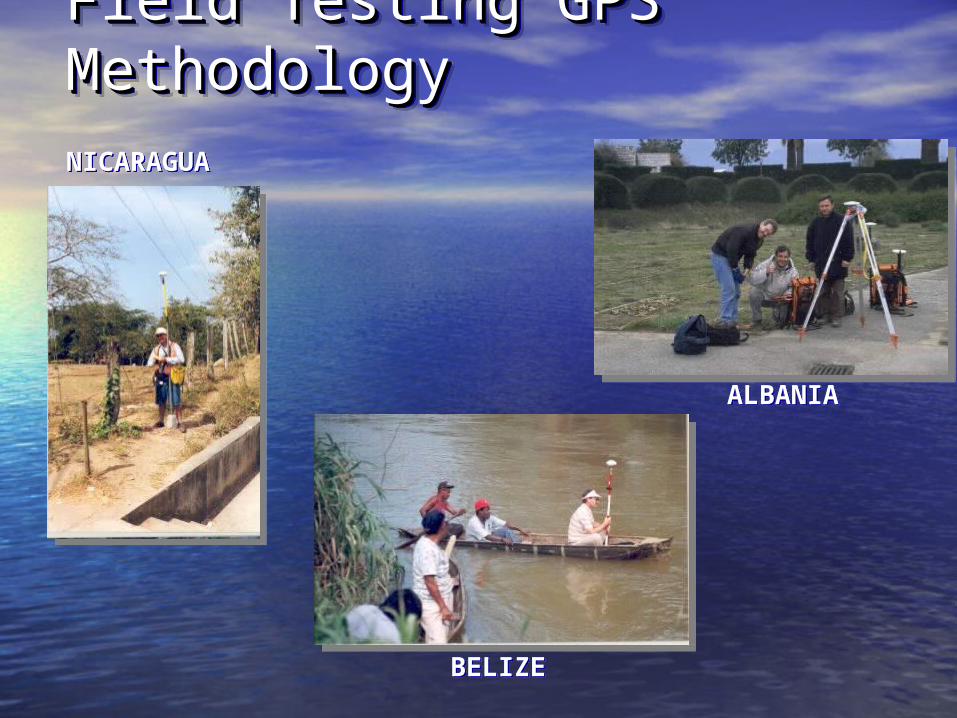
ALBANIAALBANIA
BELIZEBELIZE
NICARAGUANICARAGUA
Field Testing GPS Field Testing GPS MethodologyMethodologyField Testing GPS Field Testing GPS MethodologyMethodology

PERUPERUECUADORECUADOR
TRINIDADTRINIDAD
Field Testing GPS Field Testing GPS MethodologyMethodologyField Testing GPS Field Testing GPS MethodologyMethodology

Blunder Trapping: multipathing no of satellites and geometry “trailing” off point wrong base station coordinates change in receiver configuration (e.g. datum)
Accuracy Check: Receiver meets sub-meter accuracy occupation times sufficient
Quality Control IssuesQuality Control IssuesQuality Control IssuesQuality Control Issues

Calibration: checks receiver meets sub-meter accuracy checks occupation times sufficient
Local Reference Points: checks wrong base station coordinates entered checks change in receiver configuration
Double Base Station: checks wrong base station coordinates second BS acts as back-up
Dual Occupation: checks for multipathing checks for trailing
Quality Control MechanismsQuality Control MechanismsQuality Control MechanismsQuality Control Mechanisms

EVOLUTION OF GPS METHODOLOGY
EVOLUTION OF GPS METHODOLOGY

Evolution of the Cadastral Evolution of the Cadastral Surveying MethodologySurveying Methodology
• Initial Concept – dGPSInitial Concept – dGPS
• Field Experience Field Experience (Belize, Peru, Albania, (Belize, Peru, Albania, etc.) Reveals etc.) Reveals Complexity of the Complexity of the ProblemProblem
• The Methodology The Methodology Evolves to the Evolves to the ‘Toolbox’ Concept‘Toolbox’ Concept
Addition of Surveying Tools
dGPS
Real-time dGPS
CompassLaser Rangefinder
Orthophotography
dGPS
Tape
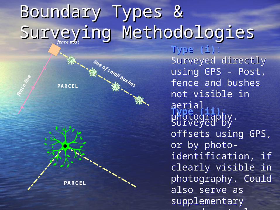
Boundary Types & Boundary Types & Surveying MethodologiesSurveying Methodologies
X
X
X
fence post
line of small bushes
fenc
e lin
e
PARCEL
PARCEL
Type (i): Surveyed directly using GPS - Post, fence and bushes not visible in aerial photography.
Type (i): Surveyed directly using GPS - Post, fence and bushes not visible in aerial photography.
Type (ii): Surveyed by offsets using GPS, or by photo-identification, if clearly visible in photography. Could also serve as supplementary ground control.
Type (ii): Surveyed by offsets using GPS, or by photo-identification, if clearly visible in photography. Could also serve as supplementary ground control.
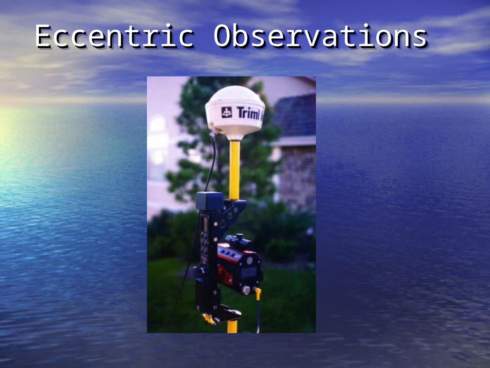
Eccentric ObservationsEccentric ObservationsEccentric ObservationsEccentric Observations

Boundary Types & Boundary Types & Surveying MethodologiesSurveying Methodologies
PARCEL
irrigation canal
a
bc
d
road
stone wall
rive
r
roa
d
pathway
inaccessible river bank surveyed by monoscopic
('heads-up') digitizing
pathway surveyed by monoscopic ('heads-up')
digitizing
PARCEL
Type (iii): Surveyed by GPS and/or by photo-identification, if clearly visible in photography. Could also serve as supplementary ground control if clearly photo-identifiable.
Type (iii): Surveyed by GPS and/or by photo-identification, if clearly visible in photography. Could also serve as supplementary ground control if clearly photo-identifiable.
Types (iv and v): Surveyed by GPS if accessible and/or by photo-identification, if not accessible and clearly visible in photography.
Types (iv and v): Surveyed by GPS if accessible and/or by photo-identification, if not accessible and clearly visible in photography.
= GPS positions

PREDIOS
Type (vi) Delineated theoretically, can be set out using real-time dGPS.
Boundary Types & Boundary Types & Surveying MethodologiesSurveying MethodologiesBoundary Types & Boundary Types & Surveying MethodologiesSurveying Methodologies

BS 1Rover
BS 2
Rover
Reference Marks
Cadastral Survey Cadastral Survey MethodologyMethodologyCadastral Survey Cadastral Survey MethodologyMethodology
(2 Central Base Stations)

Rover Rover
Reference Mark
BS/IGSLocal BS1
(Local & Central Base Stations)
Cadastral Survey Cadastral Survey MethodologyMethodologyCadastral Survey Cadastral Survey MethodologyMethodology
Local BS2

Corrections(Real Time)
Reference Marks
Rover Rover
BS
Geostationary Communication Satellite (e.g. Omnistar)
(Real-Time Corrections via Satellite
Cadastral Survey Cadastral Survey MethodologyMethodologyCadastral Survey Cadastral Survey MethodologyMethodology

Maintenance IssuesMaintenance Issues
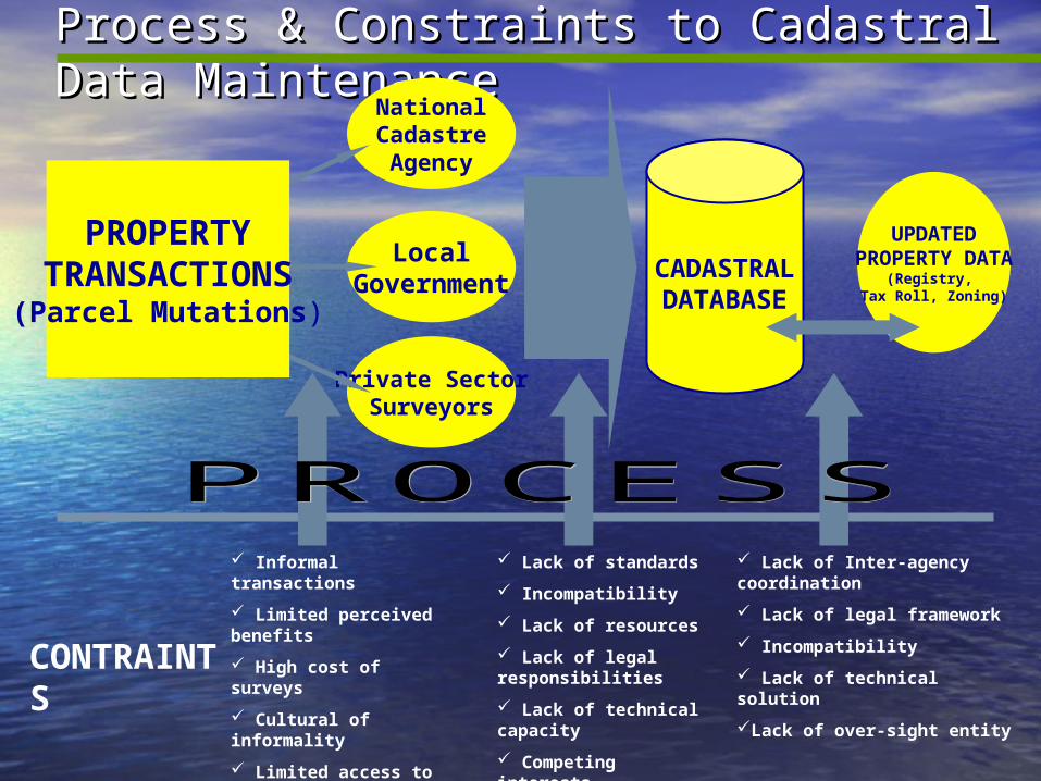
Process & Constraints to Cadastral Data Process & Constraints to Cadastral Data MaintenanceMaintenance
NationalCadastreAgency
LocalGovernment
Private SectorSurveyors
CADASTRALDATABASE
UPDATEDPROPERTY DATA
(Registry, Tax Roll, Zoning)
PROPERTYTRANSACTIONS(Parcel Mutations)
Lack of standards
Incompatibility
Lack of resources
Lack of legal responsibilities
Lack of technical capacity
Competing interests
Competing mandates
Lack of Inter-agency coordination
Lack of legal framework
Incompatibility
Lack of technical solution
Lack of over-sight entity
Informal transactions
Limited perceived benefits
High cost of surveys
Cultural of informality
Limited access to services
Lack of awareness
Lack of information
CONTRAINTS

ConclusionConclusion• Sub-meter GPS is now being used widely in Sub-meter GPS is now being used widely in
several land administration projectsseveral land administration projects• It offers a more efficient, less costly solution in It offers a more efficient, less costly solution in
certain circumstances, but not the total solutioncertain circumstances, but not the total solution• Even though benefits are proven, GPS Even though benefits are proven, GPS
technology transfer is still an obstacletechnology transfer is still an obstacle• GPS procedures need to be integrated into a GPS procedures need to be integrated into a
complete business process (office to field to complete business process (office to field to office)office)
• Need for technology extension agents (e.g. Need for technology extension agents (e.g. agriculture)agriculture)