Eelgrass in Puget Sound—A New Study of Flow, … Sound Waves September 2004 U.S. Department of the...
13
1 Sound Waves September 2004 U.S. Department of the Interior U.S. Geological Survey Fieldwork http://soundwaves.usgs.gov/ Eelgrass in Puget Sound—A New Study of Flow, Sediment Transport, and Zostera marina By Jessie Lacy (Eelgrass continued on page 2) Sound Waves Volume FY 2004, Issue No. 65 September 2004 Meadows of eelgrass (Zostera marina) provide essential habitat to a wide range of fish and wildlife in the nearshore parts of Puget Sound, WA. Birds and fish, including juvenile salmon and Pacific herring, feed on the diverse assemblage of plants and invertebrates living on the eelgrass, and the meadows provide refuge from predators for juvenile fish. Eelgrass is responsible for much of the primary production of organic carbon (the source of energy for many other organisms) both within Puget Sound and in adjacent marine waters. Eelgrass is also believed to buffer wave energy and tidal currents, reduce sediment resuspension, and retain sediment. This stabilization of the sub- strate may help to prevent beach erosion. Nutrients and organic matter retained along with the sediment contribute to the productivity of the nearshore. Eelgrass is threatened by human activi- ties that increase water turbidity (such as agriculture or road building), block light (construction of docks), or disturb the bottom (anchoring or dredging). These impacts have caused significant declines in eelgrass in many U.S. coastal waters. The Washington State Department of Natural Resources, which monitors the distribu- tion of eelgrass in Puget Sound, has not yet found evidence of large-scale loss; however, losses have occurred in some areas, and the increasing urbanization of the region poses threats to eelgrass and the entire nearshore ecosystem. As part of the Coastal Habitats in Puget Sound project, U.S. Geological Survey (USGS) scientists are investigating the ���������������� � ������ ����������� ������������������ � � � � � � � � � � � � � � � � � � � � � � � � � � � � ������� ���������� ������� � � � � � � � � � � � � � � ������� ������� Study site in In- dian Cove, Shaw Island, San Juan Islands, WA. (Left to right) Kevin O’Toole, Jessie Lacy, and Guy Gelfenbaum deploying an instrumented frame in Indian Cove. Image from the underwater video camera.
Transcript of Eelgrass in Puget Sound—A New Study of Flow, … Sound Waves September 2004 U.S. Department of the...

1 Sound Waves September 2004U.S. Department of the InteriorU.S. Geological Survey
Fieldwork
http://soundwaves.usgs.gov/
Eelgrass in Puget Sound—A New Study of Flow, Sediment Transport, and Zostera marinaBy Jessie Lacy
(Eelgrass continued on page 2)
Sound Waves Volume FY 2004, Issue No. 65September 2004
Meadows of eelgrass (Zostera marina) provide essential habitat to a wide range of fish and wildlife in the nearshore parts of Puget Sound, WA. Birds and fish, including juvenile salmon and Pacific herring, feed on the diverse assemblage of plants and invertebrates living on the eelgrass, and the meadows provide refuge from predators for juvenile fish. Eelgrass is responsible for much of the primary production of organic carbon (the source of energy for many other organisms) both within Puget Sound and in adjacent marine waters. Eelgrass is also believed to buffer wave energy and tidal currents, reduce sediment resuspension, and retain sediment. This stabilization of the sub-strate may help to prevent beach erosion. Nutrients and organic matter retained along with the sediment contribute to the productivity of the nearshore.
Eelgrass is threatened by human activi-ties that increase water turbidity (such as agriculture or road building), block light (construction of docks), or disturb the bottom (anchoring or dredging). These impacts have caused significant declines in eelgrass in many U.S. coastal waters. The Washington State Department of Natural Resources, which monitors the distribu-tion of eelgrass in Puget Sound, has not yet found evidence of large-scale loss; however, losses have occurred in some areas, and the increasing urbanization of the region poses threats to eelgrass and the entire nearshore ecosystem.
As part of the Coastal Habitats in Puget Sound project, U.S. Geological Survey (USGS) scientists are investigating the
����������������
������������������������������������
��������� �������������� �����
�������
����������
�������
����
�����
����
�
��������������
Study site in In-dian Cove, Shaw Island, San Juan Islands, WA.
(Left to right) Kevin O’Toole, Jessie Lacy, and Guy Gelfenbaum deploying an instrumented frame in Indian Cove.
Image from the underwater video camera.

2September 2004 Sound Waves
Sound Waves
Editor Helen Gibbons
Menlo Park, California Telephone: (650) 329-5042
E-mail: [email protected] Fax: (650) 329-5198
Print Layout Editors Susan Mayfield, Sara Boore
Menlo Park, California Telephone: (650) 329-5066
E-mail: [email protected]; [email protected] Fax: (650) 329-5051
Web Layout Editor Jolene Shirley
St. Petersburg, Florida Telephone: (727) 803-8747 Ext. 3038
E-mail: [email protected] Fax: (727) 803-2032
SOUND WAVES (WITH ADDITIONAL LINKS) IS AVAILABLE ONLINE AT URL http://soundwaves.usgs.gov/
Contents
Fieldwork 1Research 6Outreach 7Meetings 9Staff and Center News 12Publications 12
Fieldwork
U.S. Geological Survey Earth Science Information Sources:
Need to find natural-science data or information? Visit the USGS Frequently Asked Questions (FAQ’s) at URL http://ask.usgs.gov/faqs.html
Can’t find the answer to your question on the Web? Call 1-888-ASK-USGS
Want to e-mail your question to the USGS? Send it to this address: [email protected]
Fieldwork, continued
Submission Guidelines
Deadline: The deadline for news items and publication lists for the November 2004 issue of Sound Waves is Thursday, October 14. Publications: When new publications or products are released, please notify the editor with a full reference and a bulleted summary or description. Images: Please submit all images at publi-cation size (column, 2-column, or page width). Resolution of 200 to 300 dpi (dots per inch) is best. Adobe Illustrator© files or EPS files work well with vector files (such as graphs or dia-grams). TIFF and JPEG files work well with ras-ter files (photographs or rasterized vector files).
Any use of trade, firm, or product names is for descriptive purposes only and does not imply endorsement by the U.S. Government.
(Eelgrass continued on page 3)
dynamics of seawater flow over and through eelgrass meadows to quantify the influence of eelgrass on waves and currents and to determine whether it retains sediment. Our first study site is in Indian Cove, Shaw Island, in the San Juan Islands. Eelgrass grows taller (greater than 1 m) and in deeper water in the San Juan Islands than elsewhere in the sound because the water is clearer there.
Jessie Lacy, Guy Gelfenbaum, Jodi Harney, Kevin O’Toole, Hal Williams, Jodi Eshleman, and Dave Gonzales deployed two instrumented frames in Indian Cove from the research vessel
The frame within the meadow was in very shallow water (2.5 m MLLW), and the top half of the 2.2-m-high frame was exposed at low tide during spring tides. The Karluk was able to access the site at high tide because of the large tidal range in Puget Sound (about 3 m in the San Juan Islands).
We took high-resolution digital photo-graphs of bed sediment within and outside the eelgrass meadow to determine grain size, using technology developed by Dave Rubin, Hank Chezar, and Jodi Harney. Jodi Harney took images of the sea floor by deploying an underwater camera from the Karluk. With these images, we will gauge the influence of eelgrass on bed-sediment grain-size distribution.
Before the deployment, Jessie and sea-grass ecologist Sandy Wyllie-Echeverria
(Eelgrass continued from page 1)
Frame in seagrass meadow exposed at low tide.
Jodi Harney taking a digital photograph of beach sediment.
of the University of Wash-ington mapped the seaward edge of the eelgrass mead-ow, using boat-mounted un-derwater video and a global positioning system (GPS). Jessie mapped the landward edge of the meadow from shore at low tide.
Sandy and his family, who have been monitor-
Karluk for a two-week experiment in July. One frame was deployed within the eel-grass meadow, which extends to a depth of 5 m MLLW (mean lower low water); the other was deployed outside the meadow. Our goal was to measure velocity and suspended-sediment concentration above and within the eelgrass meadow, and to determine the influence of eelgrass on cur-rents and waves by comparing velocities measured at the two stations. Underwater video cameras were mounted on the frames to record how the posture of the eelgrass varies with current strength. This informa-tion is important in defining the vertical extent of the velocity measurements above the meadow, because the vegetation inter-feres with the acoustic velocimeters. The video also captured images of many fish in the eelgrass.
3 Sound Waves September 2004Fieldwork
Fieldwork, continued
(Eelgrass continued from page 2)
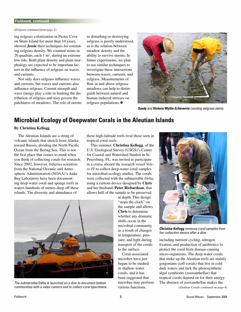
ing eelgrass colonization in Picnic Cove on Shaw Island for more than 10 years, showed Jessie their techniques for estimat-ing eelgrass density. We counted stems in 20 quadrats, each 1 m2, during an extreme low tide. Both plant density and plant mor-phology are expected to be important fac-tors in the influence of eelgrass on waves and currents.
Not only does eelgrass influence waves and currents, but waves and currents also influence eelgrass. Current strength and wave energy play a role in limiting the dis-tribution of eelgrass and may govern the patchiness of meadows. The role of storms
Sandy and Victoria Wyllie-Echeverria counting eelgrass stems.
The Aleutian Islands are a string of volcanic islands that stretch from Alaska toward Russia, dividing the North Pacific Ocean from the Bering Sea. This is not the first place that comes to mind when you think of collecting corals for research. Since 2002, however, fisheries scientists from the National Oceanic and Atmo-spheric Administration (NOAA)’s Auke Bay Laboratory have been document-ing deep-water coral and sponge reefs in waters hundreds of meters deep off these islands. The diversity and abundance of
Microbial Ecology of Deepwater Corals in the Aleutian IslandsBy Christina Kellogg
(Aleutian Corals continued on page 4)The submersible Delta is launched on a dive to document bottom communities with a video camera and to collect coral specimens.
these high-latitude reefs rival those seen in tropical coral reefs.
This summer, Christina Kellogg, of the U.S. Geological Survey (USGS)’s Center for Coastal and Watershed Studies in St. Petersburg, FL, was invited to participate in a cruise aboard the research vessel Vele-ro IV to collect deep-water coral samples for microbial-ecology studies. The corals were collected with the submersible Delta, using a custom device designed by Chris and her husband, Peter Richardson, that allows half of the sample to be preserved
at depth. This design “stops the clock” on the sample and allows Chris to determine whether any dramatic shifts occur in the microbial community as a result of changes in temperature, pres-sure, and light during transport of the corals to the surface.
Coral-associated microbes have just begun to be studied in shallow-water corals, and it has been suggested that microbes may perform various functions,
including nutrient cycling, nitrogen fixation, and production of antibiotics to protect the coral from disease-causing micro-organisms. The deep-water corals that make up the Aleutian reefs are mainly gorgonians (soft corals) that live in cold dark waters and lack the photosynthetic algal symbionts (zooxanthellae) that tropical corals depend on for their energy. The absence of zooxanthellae makes the
Christina Kellogg removes coral samples from her collection device after a dive.
in disturbing or destroying eelgrass is poorly understood, as is the relation between meadow density and the ability to survive storms. In future experiments, we plan to use similar techniques to investigate these interactions between waves, currents, and eelgrass. Measurements of flow in and above eelgrass meadows can help to distin-guish between natural and human-induced stresses on eelgrass populations.]

4September 2004 Sound Waves Fieldwork
Fieldwork, continued
(Big Sur Coast continued on page 5)
potential role of microbes (bacteria, fungi, archaea) even more interesting. The microbes may help feed these corals, similar to the chemosynthetic bacterial symbionts that feed hydrothermal-vent worms. The microbial communities of these cold-adapted corals are also likely to contain novel organisms, which will not only increase our understanding of microbial diversity but could also be a source of novel enzymes or pharmaceuticals.]
Christina Kellogg enjoys the balmy summer weather in the Aleutian Islands.
Fanellia sp., one of the deep-water gorgonian corals collected during the cruise.
Researchers from the U.S. Geologi-cal Survey (USGS)’s Coastal and Marine Geology Program and the University of California, Santa Cruz (UCSC)’s Earth Sciences Department joined together in late July to collect field data along the Big Sur coast. The team consisted of Cheryl Hapke and Krystal Green (USGS) and Ty Kennedy-Bowdoin, a UCSC gradu-ate student. The purpose of the fieldwork was to collect spectra—measurements of
Hyperspectral Data Analysis for Mapping Coastal Landslide Hazards Along the Big Sur CoastBy Cheryl Hapke and Krystal Green
reflected sunlight—from the various rock types and fault materials along the coast with a field spectrometer.
This research, which is part of the Coastal Landslides project, involves the processing and analysis of hyperspectral remote-sensing data collected via aircraft (by HyVista Corp.) in July 2003 along the Big Sur coast. Hyperspectral data provide a digital image of surface reflectance from more than 100 different spectral
tion minerals and providing high-resolu-tion information about the chemistry and spatial distribution of minerals.
The geology of the Big Sur area is highly complex, consisting of folded and faulted metamorphic rocks of the Sur com-plex and highly sheared metasedimentary and metavolcanic rocks of the Franciscan Complex. Because the Big Sur coast is remote and in many areas inaccessible, detailed geologic mapping is difficult, and so the geologic maps that do exist for the area are somewhat generalized. A focus of
(Aleutian Corals continued from page 3)
Ty Kennedy-Bowdoin and Krystal Green collect spectra from a metamorphosed quartz diorite exposed at Garrapata State Beach. Ty is wearing the sprectrometer on his back and holds the sensor to capture the reflectance from the rock surface. Krystal holds the laptop into which the data are directly recorded.
Cheryl Hapke examines the mineralogy of a serpentinite outcrop at Sand Dollar Beach. Fibrous asbestos minerals are common in the serpentinite and help to give it its characteristic “soapy” feel.
channels—discrete parts of the electromagnetic spectrum—ranging from the visible near-infrared (wavelength, 0.4-1.9 µm) to the short-wave infrared (wavelength, 2.0-2.5 µm). In comparison, standard aerial photography has three channels: red, green, and blue (all in the visible region; wavelength, 0.4-0.7 µm). Because of the large number of channels, hyper-spectral data are ideal for mapping the composition of geologic materials on the basis of their spectral sig-natures, and are especially good for detecting altera-

5 Sound Waves September 2004
Fieldwork, continued
Fieldwork
(Big Sur Coast continued from page 4)
our current research is to better understand the processes and hazards related to large coastal landslides that are common along this stretch of coast. Landslide occurrence is related to the underlying geology, spe-cifically to variations in the strength of the rocks, which is a function of the rock type, the degree of weathering, and the presence (or absence) of such geologic structures as joints, faults, and shear zones.
The objective of our hyperspectral anal-ysis is to refine existing geologic maps and to identify and map the spatial distribution of previously unmapped or unknown faults and shear zones through the detection of alteration minerals. Although existing spectral-map libraries can be used to iden-tify minerals, the spectra of a particular mineral can vary depending on the specific host rock. Therefore, collection of spectral data in the field is crucial to ground-truth the remotely sensed data.
From July 26 to 29, Cheryl, Krystal, and Ty collected numerous rock samples and recorded the spectra of the various rock types and fault materials along the Big Sur coast, using a field spectrometer. The field spectrometer, which belongs to the Naval Postgraduate School and is on loan to the UCSC Earth Sciences Depart-ment, weighs about 50 lb and is carried in a backpack. A hand-held sensor records the reflectance of sunlight off the surface of rock outcrops, which is output directly
into dedicated software in a laptop com-puter. Rock and sand samples were also collected at the outcrops so that additional analyses (measurement of rock strength and X-ray diffraction for clay identifica-tion) can be conducted. Initial processing has already identified mizzonite, chlorite, and antigorite, alteration minerals com-mon in metamorphic rocks.
The research team stayed at the Landels-Hill Big Creek Reserve’s Whale Point Research Cabin, about 80 km south of Monterey. The cabin, perched on top of a high ridge, has all the necessary amenities for fieldwork, including elec-tricity for recharging the field equipment,
corporating the results of the hyperspectral analysis into current landslide-distribution maps. The spectra collected in the field will provide additional data to expand existing spectral libraries for numerous applications, including an important goal of our project: helping the California De-partment of Transportation (Caltrans) best manage the scenic Coast Highway (Cali-fornia Highway 1) while protecting the valuable natural resources of the Monterey Bay National Marine Sanctuary.]
Ty sprays disinfectant on the bottom of Krystal’s shoes. Because of the threat of sudden oak death, we were required to clean the vehicles and disinfect our shoes each day before re-entering the reserve.
This plot dislays the spectral signatures of common meta-morphic minerals of the Big Sur coast. Mizzonite occurs in metamorphosed limestone and is found in the rocks of the Sur complex. Chlorite and epidote are common constituents of greenstone, which is abundant in the Landels-Hill Big Creek Reserve just north of Lucia; these minerals are a result of the regional metamorphism of basaltic rocks. Antigorite is a sec-ondary serpentine mineral, an abundant mineral in the serpen-tinites of the southern part of the Big Sur coast.
The Whale Point Re-search Cabin, located within the Landels-Hill Big Creek Reserve, is available by reserva-tion for university or government research-ers working in the area. The roof in the fore-ground is the Steward’s Cabin, where one of the full-time caretaker-researchers lives.
kitchen facilities, and a hot (outdoor!) shower. The Landels-Hill Big Creek Reserve, one of more than 30 wildland sites in the University of California’s Natural Reserve System and one of four such re-serves managed by UCSC, is guarding against an epi-demic of sudden oak death. As a result, upon returning from the field each day, we had to sweep the vehicles clean and disinfect the bot-toms of our shoes before entering the reserve.
The data collection was highly successful, and future work will include in-

6September 2004 Sound Waves Research
Research
Manatee populations are growing at healthy rates in two of four regions off the Florida coast but may be stalled or declin-ing in the other two regions, according to a recently released report by the U.S. Geo-logical Survey (USGS).
In three USGS-led studies—the first com-prehensive population analysis published in 9 years—scientists documented popula-tion-growth, survival, and reproduction rates of the endangered Florida manatee. The Florida Fish and Wildlife Conservation Commission, Mote Marine Laboratory, and the Florida Park Service collaborated in the research, published in the July issue of the journal Marine Mammal Science.
Population-Growth Rates “Over the past 10 years, the annual
population-growth rate in two of the regions is healthy, one region appears to be declining, and one region is probably holding steady. That’s what the science says,” said Michael Runge, lead scientist for the USGS. “We estimate that manatee populations in the Northwest and Upper St. Johns River regions have been growing annually at 3.7 percent and 6.2 percent, respectively. These estimates are in line with previous studies and, leaving a margin for error, suggest healthy growth of those populations.”
The report concludes that the estimated annual growth rate for the population in Florida’s Atlantic region is 1.1 percent, but the margin of error in this estimate is large enough that it is possible the population is stable or slightly declining. In the South-west region, the estimated population growth rate is negative (–1.1 percent per year); however, the margin of error in this estimate is larger than in the other regions.
“The estimates for the Atlantic and South-west are of concern, because these regions
Manatee Population Rising in Some Regions, Likely Stalled or Declining in OthersBy Michael C. Runge
95.6 percent in the Northwest region, 96 percent in the Upper St. Johns River re-gion, 93.7 percent in the Atlantic region, and 90.8 percent in the Southwest region.
“Field efforts by the Florida Fish and Wildlife Conservation Commission and the Mote Marine Laboratory over the years have allowed us to estimate survival rates in the Southwest for the first time,” said Langtimm. “While this monitoring achieve-ment is exciting, the survival rates them-selves are disappointing in the Southwest.”
Langtimm and collaborators were also able to make formal statistical estimates of calf survival for the first time. In the Up-per St. Johns River region, the only region where scientists could reliably identify calves, annual survival rates were 81 per-cent for first-year calves and 92 percent for second-year calves.
Reproduction Rates The other companion study, led by
USGS scientist William Kendall, estimat-ed manatee reproductive rates from photo-identification data in the Northwest and Atlantic regions. When field personnel take photographs, they record whether a female is with a first-year calf. Because scientists can identify individual adult females from scar patterns, they can reconstruct the female’s reproductive history and estimate reproductive rates. Kendall and colleagues found that adult females in the Northwest region without a dependent first-year calf have a 43-percent probability of producing a calf over the next year; this probability is 38 percent in the Atlantic region. Similar estimates are not yet available for the Up-per St. Johns River or Southwest regions. Scientists expect that this new analytical method is applicable to many other ma-rine-mammal populations.]
U.S. and Canadian partners have devel-oped a new online mapping service that brings together U.S. Geological Survey (USGS) data and data sets from other government agencies and research institu-
Online Mapping Service for the Gulf of MaineBy Fran Lightsom
tions that are active in the Gulf of Maine. The final project meeting of “Building a Spatial Data Framework in the Gulf of Maine to Support Benthic Mapping for Resource Management” was held August
9 in the conference center of the New England Aquarium. The meeting featured a presentation of the Gulf of Maine Map-ping Portal (GoMMaP), which allows
(Online Mapping continued on page 7)
make up most of the manatee population,” said Runge.
These findings estimate annual popula-tion-growth rates over the past decade, using survival and reproductive rates from the two companion studies. The modeling work indicates that these growth rates are largely driven by adult survival, a result that has implications for both monitoring and management.
“First, we need better estimates of adult survival, especially in the Atlantic and South-west regions; this involves a strong commit-ment to the continuation of long-term moni-toring,” Runge said. “Second, recovery of the species may largely depend on achieving and maintaining high adult-survival rates.”
Survival Rates One companion study, led by USGS sci-
entist Catherine Langtimm, estimated the survival rates of adults and calves. Every year, scientists from several Federal, State, and private agencies photograph individual manatees. Many manatees can be uniquely identified by their scar patterns, and this identification provides the information to estimate survival rate in a statistically sound manner. The estimated annual adult-survival rates over the past decade were
Close-up of manatee face. Photograph courtesy of the Sirenia Project, USGS.

7 Sound Waves September 2004Research, Outreach
Research, continued
(Online Mapping continued from page 6)
online users to create their own maps by selecting regions, base maps, and data. The portal is also a Web service that al-lows other organizations to present cus-tomized Internet mapping services as part of their Web sites. USGS data, including freshwater features and seabed sediment
type, are among the basic maps offered by GoMMaP. USGS interpretations of coastal geomorphology and coastal vulnerability to sea-level rise are also available. After GoMMaP is released publicly at the Gulf of Maine Summit, to be held October 26-29 in St. Andrews, New Brunswick,
Canada, the portal will go online at URL http://www.gommap.org/. This project was jointly sponsored by the Federal Geo-graphic Data Committee (FGDC) and the Canadian agency GeoConnections. USGS contributions were arranged by Brad But-man and Valerie Paskevich.]
On August 2, 2004, Carlton Roches-ter, a U.S. Geological Survey (USGS) sci-entist working at the Western Ecological Research Center (WERC) in San Diego, CA, presented the third annual “Snake Talk” for 8 members of the Youth Conser-vation Corps (YCC) and 30 members of the California Conservation Corps (CCC) at Cabrillo National Monument, located at the tip of Point Loma peninsula, San Di-ego. The presentation included three live snake species. A San Diego gopher snake was presented as an example of a common native species that the two workgroups might encounter within the park. Two coastal rosy boas were shown as examples of a snake species that is present but not common within the park, where just one individual has been detected. Finally, a California glossy snake represented a species that is suspected to have lived on Point Loma peninsula historically but has not been detected in more than 7 years of USGS reptile and amphibian research in the park.
From 1995 through 2002, the USGS conducted pitfall-trap sampling at 17 points throughout Cabrillo National Mon-ument. These efforts resulted in 1,900 rep-tile and amphibian captures, representing 13 species. Since 2002, the National Park Service has continued these pitfall-trap efforts. The USGS supports the National Park Service by providing tools and re-sources needed to collect the data, such as digital data forms used to collect field data on handheld computers.
On July 8, 2004, another WERC scien-
Scientists Come to the Point to Talk About Snakes and Birds at Cabrillo National MonumentBy Carlton Rochester and Mark Mendelsohn
tion step of the scientific method, includ-ing field techniques of using vocalizations played from a portable device to entice birds to respond and thus facilitate detec-tion, and the important skill of writing a species account while observing wildlife.
A full year of surveys of the greater road-runner at Cabrillo National Monument and many other sites across the county has been completed, and analysis begun, in an effort to reveal the causes of declining roadrunner numbers in the region.]
San Diego gopher snake. For information about this species and other reptiles and amphibians of coastal southern California, visit URL http://www.werc.usgs.gov/fieldguide/. Photograph by Chris-topher W. Brown, USGS.
Greater roadrunner, photo-graphed by Mark Mendelsohn. Mark’s Master’s thesis research highlights the im-portance of maintaining large open spaces for this species, which is negatively affected by habitat fragmentation in San Diego County. More in-formation about the greater roadrunner is available at URL http://www.mbr-pwrc.usgs.gov/infocenter/i3850id.html.
Outreach
tist, Mark Mendelsohn, gave a brief presentation for eight YCC members on studies of the local bird community at Ca-brillo National Monu-ment. His presentation included an interactive discussion of graduate research on the greater roadrunner in San Diego County, contrasted with other bird species that currently inhabit the pe-ninsula. The enthusiastic YCC members were ex-posed to the data-collec-

8September 2004 Sound Waves Outreach
Outreach, continued
“Mentoring provides a unique oppor-tunity to change lives—a child’s and your own. I encourage everyone to mentor. In this complex world, it is a simple way to make a difference.”
Mayor Rick Baker
The mayor of St. Petersburg, FL, strummed his guitar while students from Perkins Elementary School’s orchestra and chorus sang “We Are The World.” At an April 14 ceremony, Mayor Rick Baker announced the successful recruitment of partners for all of St. Petersburg’s 27 ele-mentary schools, 9 middle schools, 5 high schools, and 3 secondary schools. Partners will work with the schools in various ways, some providing financial support, others sending employees to lend volun-teer support. The ceremony gave partners and school principals the opportunity to
USGS Partners with St. Petersburg, FL, Elementary SchoolBy Jennifer Leigh Oates
meet and get excited about the countless partnership possibilities. The U.S. Geo-logical Survey (USGS) will be a partner to Bay Point Elementary Magnet School, known as the “Center for the Advance-ment of Science and Technology.” Echelon Real Estate Services and the USGS will work together to meet the financial and scientific needs, respectively, of the stu-dents and teachers at Bay Point.
The purpose of the Mayor’s Mentors & More Initiative is to help students ex-cel and to augment the limited resources available to local schools. Mayor Baker
St. Petersburg mayor Rick Baker plays “We Are The World” on his guitar while students from Per-kins Elementary School sing.
(Left to right) Lisa Robbins (chief of the USGS’s Center for Coastal and Watershed Studies), Rick Baker (mayor of St. Petersburg), and Gaye Lively (principal of Bay Point Elementary School) embrace after a ceremony dedicated to helping St. Petersburg students.
believes that it is important for the com-munity to get involved in improving edu-cation. By increasing school standards, he hopes to attract larger companies to the St. Petersburg area. Mayor Baker said that major concerns for companies considering relocation to St. Petersburg are “Where will my employees’ children be attending school?” and “Can we expect a qualified workforce from local schools?”
Other partners with Pinellas County el-ementary schools include the University of South Florida, the U.S. Coast Guard, and numerous private firms.
Mayor Baker and his staff would like to see the idea of corporate mentoring take root in other cities. To support the spread of community responsibility across Ameri-ca, the mayor decided to make information and advice available from his office. To learn more, visit the Mayor’s Mentors & More Web site at URL http://www.stpete.org/mentors.htm.]
Teachers gathered in the cafeteria at Bay Point Elementary Magnet School on July 29 to meet Lisa Robbins, director of the U.S. Geological Survey (USGS)’s Center for Coastal and Watershed Stud-ies in St. Petersburg, FL, and to hear what the USGS can do to enhance the learning experience for students. Bay Point is known as the “Center for the Advancement of Science and Technol-ogy.” Jennifer Oates accompanied Lisa to the welcome breakfast, prepared by the local PTA. Lisa stressed the need for teachers to use the USGS as a resource. Educational handouts, coloring sheets, CDs, and posters were given to teach-ers to use in the classroom. The teachers were appreciative and eager to hear about USGS student and teacher resources available online (at URL http://www.usgs.gov/education/). Teachers unable to devote an entire day to a field trip be-
Local School Welcomes USGS as its Partner in the Mayor’s Mentors & More InitiativeBy Jennifer Leigh Oates
cause of standardized test requirements in Florida were intrigued by the virtual tours available on the USGS’s SOFIA Web site (at URL http://sofia.usgs.gov/virtual_tour/). When asked what they needed, teachers mentioned grade-level tours of the USGS facility and scientific-research presentations. Scientists in the St. Petersburg center have been asked to participate, and some have offered to be mentors or give presentations. As a parent and educator, Lisa feels strongly about the USGS partnership with Bay Point. Principal Gaye Lively and Science Resource Specialist Ron Woolums are the two contacts at Bay Point. For more information about Bay Point, visit the school’s Web site at URL http://www.geocities.com/Athens/Acropolis/8714/. For more information about the Mayor’s Mentors & More Initiative, visit URL http://www.stpete.org/mentors.htm.

9 Sound Waves September 2004Outreach, Meetings
Outreach, continued
Eighteen middle- and elementary-school teachers gathered at a summer training session at Weedon Island Preserve in St. Petersburg, FL, on July 27. Cindy Benkert, a member of Suncoast Earth Force, orga-nized presenters from the Tampa Bay area to share information and resources from the U.S. Geological Survey (USGS)’s Center for Coastal and Watershed Studies, MacDill Air Force Base, and the Tampa Bay His-tory Center. Representing the USGS was Jennifer Oates, who gave a PowerPoint
USGS Participates in Earth Force Teacher TrainingBy Jennifer Leigh Oates
presentation on educational resources avail-able online and locally at the center, and distributed a bag of educational materials to each teacher. She received teachers’ re-quests for a Spanish-speaking classroom presenter, WETMAAP (Wetland Education Through Maps and Aerial Photography) workshops, presenters during the Great American Teach-in, teacher tours, meetings with scientists, and invitations to the annual St. Petersburg USGS Open House. The two South Florida ecosystems posters that Jen-
nifer brought were so popular that they had to be given away in a raffle.
Earth Force is a national nonprofit organi-zation that provides opportunities for young people to understand, improve, and sustain the natural environment in their community. Its award-winning programs are aimed at teaching youths of high-school age essential academic skills, including critical thinking, teamwork, problem solving, and decision making. For more information, visit URL http://www.earthforce.org/.]
Meetings
The American Geophysical Union (AGU) Chapman Conference on “Salt Marsh Geomorphology: Physical and Eco-logical Effects on Landform” will be held in Halifax, Nova Scotia, Canada, on Octo-ber 9-13, 2004. The preliminary program and field trip and registration information are available on the conference Web site at URL http://www.geol.sc.edu/chapman/. The goal of this conference is the integra-tion of physical and ecological sciences to enhance our understanding of the interac-tions between salt-marsh geomorphology and intertidal sedimentary processes.
This meeting will promote discussion be-tween ecosystem and physical scientists who
Upcoming! AGU Chapman Conference on Salt MarshesBy Donald R. Cahoon
otherwise may not communicate with each other about their respective fields of research. We hope that the meeting structure of plenary sessions, small breakout-group meetings, and two field trips will facilitate that discus-sion and, ultimately, help define how physics and ecology interact to produce and main-tain salt marshes. At the end of the meeting, we expect to have a clearer view of where the sciences of salt-marsh physics and ecol-ogy are, where they need to be, and how to get there. The invited speakers and contribu-tors were selected because of their potential to stimulate cross-disciplinary discussion.
As of August 9, 2004, 66 abstracts had been submitted from 16 countries, evaluat-
ing the interrelations among physical forc-ings, ecological processes, and sedimenta-ry processes and their combined influence on coastal landforms. The U.S. Geological Survey (USGS) is a sponsor of the confer-ence, along with the American Society of Limnology and Oceanography (ASLO), the International Association of Geomor-phologists (IAG), several academic institu-tions, and other Federal agencies.
For further information about the con-ference, contact the conference organizers through the Web site: Dr. Ray Torres, University of South Carolina, Dr. Danika van Proosdij, Dr. Sergio Fagherazzi, or Dr. Charles Hopkinson.]
Educators and scientists traveled to St. Petersburg, FL, to participate in the 28th annual National Marine Educators As-sociation (NMEA) conference on July 18-22. The U.S. Geological Survey (USGS)’s Center for Coastal and Watershed Studies participated with eight presenters. Teach-ers were eager to gather lesson plans, lists of useful Web sites, handouts, coloring sheets, and CDs from the booths and con-ference sessions. The 2005 NMEA confer-ence will be held in Maui, Hawai’i. For more information, visit the NMEA Web
National Marine Educators Attend Conference in St. Petersburg, FLBy Jennifer Leigh Oates
site at URL http://www.marine-ed.org/.Lisa Robbins (USGS, St. Petersburg)
participated in two conference sessions. Robbins was a panelist in a session called “Beach Literacy in America,” with mem-bers from the Clean Beaches Council, the Pinellas County Health Department, and Sea Grant programs at the Virginia Insti-tute of Marine Science and the University of Virginia. Discussion topics included beach water quality, habitat conservation, erosion management, safety education, and litter education and prevention. As
an invited general-session speaker at the Florida Marine Research Institute, Rob-bins joined Peter Betzer from the College of Marine Science, University of South Florida (USF), to discuss the importance of “building bridges” between scientific research, the public, and students.
Educators toured the USGS facility in St. Petersburg, where they examined core samples in the sediment lab, touched corals, learned how to forecast hurricanes, and saw how easily ground water can be
(Marine Educators continued on page 10)

10September 2004 Sound Waves
Meetings, continued
Meetings
(Marine Educators continued from page 9)
contaminated. The four hands-on scientific sessions gave educators the opportunity to ask USGS scientists questions and gather educational information. Dennis Krohn (USGS, St. Petersburg) gave an introductory presentation to the visitors. Jim Flocks (USGS, St. Petersburg) spoke in the sediment lab, where he had sections of “working” cores displayed to allow educators to see how variations in the sediment reflect the history of the Earth over thousands of years. He showed how cores are X-rayed, sliced, and archived and explained causes of subsidence in Louisiana (visit URL http://coastal.er.usgs.gov/projects/location/louisiana.html for more information).
Don Hickey (USGS, St. Petersburg) had a table of corals and educational materi-
St. Petersburg) gave an overview of Abby Sallenger’s “National Assessment of Coastal Change Hazards” Web site (at URL http://coastal.er.usgs.gov/national-assessment/). Morgan discussed how she forecasts the impacts of storms, using LIDAR (LIght Detection And Ranging) images from Hurricane Isabel as an example.
Ann Tihansky (USGS, Tampa, FL) spoke about ground-water contamination and water sources. The educators enjoyed watching a video that documented the discovery of wells and showed how carefully divers must maneuver through shallow underground wa-terways. Discussion focused on where, how, and why sinkholes are formed.
Brian Bossak (USGS, St. Petersburg) and Tara Miller (ETI Professionals contractor at USGS, St. Petersburg) together presented a session titled “Geographic Information Science: Applications to Coastal Hazard Research.” Bossak gave an overview of geographic information systems (GIS) and their uses in coastal studies,
LIDAR data and how it can be integrated within a GIS, and current work at the USGS (such as the development of a digital tool integrating GIS information, remote-sensing data, and storm parameters to estimate coastal storm impact; see URL http://geology.usgs.gov/postdoc/profiles/bossak.html). Miller discussed the completion of the Gulf of Mexico part of the National Assessment of Shoreline Change Project headed by USGS principal investigator Bob Morton. The project marks the first-ever analysis of historical shoreline change along the entire conterminous United States and parts of Alaska and Hawaii. The analysis looks at shoreline change from early maps made in the 1800s to today, using LIDAR measurements made as recently as 2002 (for more information, visit URL http://coastal.er.usgs.gov/shoreline-change/).
For more information about the NMEA 2004 Conference, visit URL http://www.floridamarine.org/features/category_main.asp?id=2088.]
Don Hickey fielded NMEA educators’ questions about African dust.
Brian Bossak and Tara Miller talked about digital tools used in coastal studies.
als, and an elaborate exhibit board for educators to exam-ine. Hickey discussed USGS coral-reef research and dis-eases affecting reefs. Several educators wanted to know how the African dust theory played a role in the declin-ing health of reefs (for more information, visit URLs http://walrus.wr.usgs.gov/coralreefs/intro.html and http://coastal.er.usgs.gov/african_dust/).
Karen Morgan (USGS,
Jim Flocks showed visitors in the sediment lab how core sam-ples are collected and analyzed.
Karen Morgan explained how LIDAR was used to detect shore-line changes after Hurricane Isabel.

11 Sound Waves September 2004Meetings
Meetings, continued
Woods Hole Scientific Community Diversity Initiative and Sea Education Association Diversity WorkshopBy Jamey M. Reid
On July 27, 2004, the leaders of the six scientific organizations in the Woods Hole, MA, area officially established the Woods Hole Scientific Community Diversity Ini-tiative. A memorandum of understanding (MOU) was signed with the purpose of working cooperatively to increase diver-sity in the local area and in the sciences. The participating organizations include the Marine Biological Laboratory, the Nation-al Marine Fisheries Service of the National Oceanic and Atmospheric Administration (NOAA), the Sea Education Associa-tion (SEA), the U.S. Geological Survey (USGS)’s Woods Hole Science Center, the Woods Hole Oceanographic Institution, and the Woods Hole Research Center.
The goals of the initiative include: 1. to provide advice to Woods Hole scien-
tific organizations; 2. to be a resource through sponsored ac-
tivities and referrals; and 3. to cooperatively undertake recruitment,
retention, and mentoring programs that will result in a diverse group of students, employees, and researchers in ocean sciences, biological sciences, geosciences, ocean engineering, and marine and environmental policy.
The participating agencies acknowledge that significant barriers exist between the present situation and their future goals, and they are prepared to gather the resources
needed to overcome those barriers. The MOU is designed to “create pathways of opportunity that will attract people from underrepresented groups by showing that the Woods Hole scientific and educational community has opportunities beginning with primary education and leading to high-er education, postgraduate work, research, and lifetime careers both in Woods Hole and in the global scientific community.”
The signing of the MOU kicked off the 2004 SEA Diversity Workshop, the third in a series of four workshops funded by the Andrew Mellon Foundation. The workshop brings together participants from More-house College, the Marine Biological Labo-ratory, Clark Atlanta University, the USGS, Cornell University, the ACE Foundation in Bermuda, Carlton College, NOAA, Har-vard College, the National Science Founda-tion, Howard University, the Los Angeles Maritime Institute, Hampton University, and the Andrew Mellon Foundation.
Participants in this year’s workshop attended mini-lectures in oceanography and nautical science and participated in a three-day cruise on the sailing school ves-sel (SSV) Corwith Cramer, one of SEA’s research sailing vessels. The participants experienced, firsthand, everything students encounter during the SEA programs, in-cluding sailing, deploying oceanographic equipment, and conducting laboratory procedures, as well as cooking, cleaning, and doing what it takes to maintain the ship. Members of the ship’s crew walked participants through man-overboard, fire, and abandon-ship drills. During the cruise, the participants had frank discussions about diversity-related issues and barriers. In three short days, it became clear that the impact of a SEA semester in the life of a student goes far beyond science and adds to overall life skills as well. Students emerge with not only a better understand-ing of oceanography but also a tremendous increase in confidence and self-esteem—two traits that are important in self-devel-opment. In addition, they learn survival, teamwork, and leadership skills. All of this
USGS participant Jamey Reid (center of photo-graph) and Howard University associate provost Joseph Reidy (lower left) climb the ship’s rigging.
packaged together enables these students to become highly competitive as they seek future work and success in the sciences.
The participants held a wrapup session when they returned to the SEA campus. The session resulted in a list of actions for SEA to incorporate into its diversity plan, as well as actions for the participants to take with them to their home organizations in support of SEA. SEA will reconvene the workshop in 2005, bringing together all of the partici-pants from the first three workshops.]
NOAA scientist Ambrose Jearld and SEA as-sistant scientist Suzanne Renssalaer prepare to deploy a Shipek grab sampler.
SEA Diversity Workshop participants say good-bye to the sailing school vessel (SSV) Corwith Cramer.

12September 2004 Sound Waves Staff and Center News, Publications
Staff and Center News
Jodi Eshleman has recently joined the U.S. Geological Survey (USGS)’s Western Coastal and Marine Geology Team as an oceanographer who will be working with Guy Gelfenbaum.
Jodi received a B.S. degree in civil engineering from Lehigh University and recently completed an M.S. degree in coastal engineering at the University of Florida. While working on her Master’s research, she spent 8 months at the U.S. Army Corps of Engineers’ Field Research Facility in Duck, NC, where she gained valuable field experience collecting cross-shore profiles with the amphibious LARC and CRAB vehicles, and a backpack-mounted GPS (global positioning sys-tem). This experience will be beneficial at the USGS, where Jodi will be working
Oceanographer Joins the Western Coastal and Marine Geology TeamBy Guy Gelfenbaum
Jodi Eshleman programs a current meter before data collection as part of a recent field investigation of eelgrass in Puget Sound, WA (see article “Eelgrass in Puget Sound,” this issue).
with Guy, Peter Ruggiero, and Dan Hanes in the Coastal Evolu-tion Modeling project to collect nearshore bathymetric data with the Coastal Profiling System (a waverunner equipped with a GPS receiver and an echo sounder to measure depth).
In addition, Jodi will be primar-ily involved in the new Coastal Habitats in Puget Sound project. Her efforts will focus on all aspects of the project, from data collection in the field to processing, analyz-ing, compiling, and presenting the results of the study.
Please come by Room 1213 in the Menlo Park, CA, office and welcome Jodi to the USGS.]
Publications
Barnhardt, W.A., Jaffe, B.E., Kayen, R.E., and Cochrane, G.R., 2004, Influence of near-surface stratigraphy on coastal landslides at Sleeping Bear Dunes National Lakeshore, Lake Michigan, USA: Journal of Coastal Research, v. 20, no. 2, p. 510-522.
Calderon, K., Dadisman, S.V., Kindinger, J.L., Davis, J.B., Flocks, J.G., and Wiese, D.S., 2004, Archive of digital boomer seismic reflection data collected during USGS cruises 93LCA01 and 94LCA01 in Kingsley, Orange, and Lowry Lakes, northeast Florida, 1993 and 1994: U.S. Geological Survey Data Series DS-100 [DVD].
Calderon, K., Dadisman, S.V., Kindinger, J.L., Flocks, J.G., Ferina, N.F., and Wiese, D.S., 2004, Archive of digital boomer and chirp seismic reflection data collected during USGS cruises 01RCE05 and 02RCE01 in the Lower Atchafalaya River, Mississippi River Delta, and offshore southeastern Louisiana, October 23-30, 2001, and August 18-19, 2002: U.S. Geological Survey Data Series DS-95 [DVD].
Recently Published ArticlesCalderon, K., Dadisman, S.V., Kindinger,
J.L., Flocks, J.G., Morton, R.A., and Wiese, D.S., 2004, Archive of digital boomer seismic reflection data collected during USGS cruises 94CCT01 and 95CCT01, eastern Texas and western Louisiana, 1994 and 1995: U.S. Geological Survey Data Series DS-93 [DVD].
Hallock, P., Lidz, B.H., Carnahan, E., Daniels, C., and Hoare, A.M., 2004, Three low-cost tools for reef monitoring and risk assessment; distinguishing local from global stresses: International Coral Reef Symposium, 10th, Okinawa, Japan, June 28-July 2, 2004, Abstracts, p. 332.
Hallock, P., Lidz, B.H., Carnahan, L., Daniels, C., and Hoare. A.M., 2004, Distinguishing local from global stresses; low-cost tools for reef monitoring and risk assessment: Association for Tropical Biology and Conservation (ATBC) Annual Meeting, Miami, FL, July 12-15, 2004, Abstracts, p. 75.
Lipp, E.K., Jarrell, J.L., Griffin, D.W., Lukasik, J. Jacukiewicz, J., and Rose, J.B., 2002, Preliminary evidence for
human fecal contamination in corals of the Florida Keys: Marine Pollution Bulletin, v. 44, no. 7, p. 666-670.
Poppe, L.J., Eliason, A.H., and Hastings, M.E., 2004, A Visual Basic program to generate sediment grain-size statistics and extrapolate particle distributions: Computers & Geosciences, v. 30, no. 7, p. 791-795.
Ruggiero, Peter, Holman, R.A., Beach, R.A., 2004, Wave run-up on a high-energy dissipative beach: Journal of Geophysical Research, v. 109, C06025, doi: 10.1029/2003JC002160, 2004.
Shinn, E.A., Griffin, D.W., and Seba, D.B., 2004, Atmospheric transport of mold spores in clouds of desert dust: Archives of Environmental Health, v. 58, no. 8, p. 498-504.
Warner, J.C., Sherwood, C.R., Arango, H.G., and Signell, R.P., 2004, Performance of four turbulence closure models implemented using a generic length scale method: Ocean Modeling, v. 8, no. 1-2, p. 81-113.]

13 Sound Waves September 2004Publications
Publications, continued
Conrad, J.E., Sliter, R.W., and Ryan, H.F., Characteristics of the southern part of the Palos Verdes fault from high-resolution and multichannel seismic reflection data [abs.]: Southern California Earthquake Center (SCEC) Annual Meeting, Palm Springs, CA, Sept. 19-22, 2004.
Edwards, R.E., and Raabe, E.A., Ecological characteristics and forcing functions of the Suwannee River Estuary [abs.]: USGS Suwannee River and Estuary Initiative Integrated Science Workshop, Cedar Key, FL, September 22-24, 2004.
Griffin, D.W., and Gray, M.A., Source tracking and microbial water quality in three Florida Springs [abs.]: USGS Suwannee River and Estuary Initiative Integrated Science Workshop, Cedar Key, FL, September 22-24, 2004.
Hall, D.K., Williams, R.S., Jr., Steffen, K., and Chien, J.Y.L., Analysis of summer 2002 melt extent on the Greenland ice
Publications Submitted for Director’s Approvalsheet using MODIS and SSM/I data: Institute of Electrical and Electronic Engineers’ International Geoscience and Remote Sensing Symposium (IGARSS 2004), Anchorage, Alaska, September 20-24, 2004, Proceedings.
Hapke, Cheryl, and Green, Krystal, Coastal landslide activity and coastal cliff retreat: U.S. Geological Survey Fact Sheet.
Normark, W.R., Baher, Shirley, and Sliter, Ray, Late Quaternary deformation in Santa Monica Basin deposits adjacent to Santa Cruz-Catalina Ridge, offshore southern California [abs.]: Southern California Earthquake Center (SCEC) Annual Meeting, Palm Springs, CA, September 19-22, 2004.
Poore, B.S., Integrating information for watershed management; a Suwannee River Basin watershed atlas [abs.]: USGS Suwannee River and Estuary Initiative Integrated Science Workshop, Cedar Key, FL, September 22-24, 2004.
Poore, R.Z., Pavich, M.J., and Grissino-Mayer, H.D., Record of North American southwest monsoon from Gulf of Mexico sediment cores: Geology.
Raabe, E.A., Edwards, R.E., and McIvor, C.C., Structural and dynamic habitat in the Suwannee estuary; an application of remotely sensed imagery to integrated habitat mapping [abs.]: USGS Suwannee River and Estuary Initiative Integrated Science Workshop, Cedar Key, FL, September 22-24, 2004.
Raabe, E.A., Slow energy, fast transgressions; status of knowledge in Florida’s Big Bend [abs.]: Geological Society of America Annual Meeting, Denver, CO, November 7-10, 2004.
Warrick, J.A., Historical erosion rates of coastal California—what is “natural”? [abs.]: Headwaters to Oceans (H2O) Conference, Long Beach, CA, October 28-30, 2004.]