Ecology is for the Peopl Nilesh.doc - Wikimedia Commons · 2018-01-08 · Ecology is for the...
237
Ecology is for the People: A Methodology Manual for People’s Biodiversity Register Madhav Gadgil Centre for Ecological Sciences Indian Institute of Science Bangalore 560012, India & Agharkar Research Institute Agarkar Road, Pune 411004, [email protected] http://ces.iisc.ernet.in/hpg/cesmg/ in collaboration with K.P.Achar, Harish Bhat, P.R. Bhat, Shubhada Deshmukh, Ajay Dolke, Yogini Dolke, N. Vijay Edlabadkar, A.K. Ghosh, Satish Gogulwar, Yogesh Gokhale, Shrikanth Gunaga, B.V. Gundappa, Nilesh Heda, Mohan H. Hiralal, N. Indiramma, Kailash C. Malhotra, M.B.Naik, M.P.Nair, N.H.Ravindranath, G. Nalini Rekha, Kaustubh Pandharipande, S.G.Patgar, Ramakrishnappa, P.R. Seshagiri Rao, V.V. Sivan, S. Srinidhi, S. Sujith, K.A. Subramanian, Devaji Tofa, C. Yathiraju National Workshop on People’s Biodiversity Register 22-23 June 2006 Chennai
Transcript of Ecology is for the Peopl Nilesh.doc - Wikimedia Commons · 2018-01-08 · Ecology is for the...

Ecology is for the People:
A Methodology Manual for People’s
Biodiversity Register
Madhav Gadgil
Centre for Ecological Sciences
Indian Institute of Science
Bangalore 560012, India
&
Agharkar Research Institute
Agarkar Road, Pune 411004,
http://ces.iisc.ernet.in/hpg/cesmg/
in collaboration with
K.P.Achar, Harish Bhat, P.R. Bhat, Shubhada Deshmukh, Ajay
Dolke, Yogini Dolke, N. Vijay Edlabadkar, A.K. Ghosh, Satish
Gogulwar, Yogesh Gokhale, Shrikanth Gunaga, B.V. Gundappa,
Nilesh Heda, Mohan H. Hiralal, N. Indiramma, Kailash C.
Malhotra, M.B.Naik, M.P.Nair, N.H.Ravindranath, G. Nalini
Rekha, Kaustubh Pandharipande, S.G.Patgar, Ramakrishnappa,
P.R. Seshagiri Rao, V.V. Sivan, S. Srinidhi, S. Sujith, K.A.
Subramanian, Devaji Tofa, C. Yathiraju
National Workshop on People’s Biodiversity Register
22-23 June 2006
Chennai


i
CONTENTS
1 PREFACE ..................................................................................................................................... 1
2 INTRODUCTION ........................................................................................................................ 3
3 BIOLOGICAL DIVERSITY ACT.............................................................................................. 5
4 FUNCTIONS OF PEOPLE’S BIODIVERSITY REGISTERS................................................ 6
5 BIODIVERSITY INFORMATION SYSTEM......................................................................... 16
6 PBR PROCESS........................................................................................................................... 28
7 SPREADING AWARENESS .................................................................................................... 31
8 PEOPLE’S CONCERNS ........................................................................................................... 33
9 INDIVIDUAL BIODIVERSITY PROJECTS ......................................................................... 35
10 DEPLOYING STUDENT POWER ...................................................................................... 36
11 MANAGING THE INFORMATION ................................................................................... 39
12 THEMES AND METHODS .................................................................................................. 55
13 PEOPLESCAPE ..................................................................................................................... 70
14 MAPPING THE LANDSCAPE ............................................................................................ 86
15 SKETCHING THE LIFESCAPE ......................................................................................... 93
16 SETTING OF THE STUDY SITE...................................................................................... 102
17 FOCAL ISSUES ................................................................................................................... 103
18 LANDSCAPE TYPES AND SUB-TYPES.......................................................................... 106
19 FOCAL ELEMENTS OF LANDSCAPE/ WATERSCAPE ............................................. 117
20 FOCAL LIFE FORMS ........................................................................................................ 126
21 KNOWLEDGE ..................................................................................................................... 130
22 MANAGEMENT.................................................................................................................. 134
23 NATIONAL LEVEL SUPPORT......................................................................................... 147
24 ACKNOWLEDGEMENTS ................................................................................................. 149
25 REFERENCES ..................................................................................................................... 150
26 APPENDIX 1: POSSIBLE APPLICATIONS OF INFORMATION COLLECTED
THROUGH THE PBR PROCESS FROM THE PERSPECTIVE OF THE LOCAL
COMMUNITY MEMBERS .................................................................................................................... 151
27 APPENDIX 2: PRINCIPLES OF THE ECOSYSTEM APPROACH ADOPTED BY
CBD 156

ii
28 APPENDIX 3: SALIENT FEATURES OF MEMORANDUM OF AGREEMENT
BETWEEN KNOWLEDGE HOLDERS OF MALA GRAM PANCHAYAT, KARKALA
TALUK, UDUPI DISTRICT, KARNATAKA AND THE NATIONAL INNOVATION
FOUNDATION......................................................................................................................................... 157
29 APPENDIX 4: BIODIVERSITY RELATED TOPICS FOR ENVIRONMENTAL
EDUCATION PROJECTS FOR PRIMARY, HIGH SCHOOL AND COLLEGE STUDENTS
THAT WILL SUPPORT PBR ACTIVITIES. ....................................................................................... 161
30 ANNEXURE: SCREEN SHOTS OF PBR DATA ENTRY FORMS............................... 179

Preface
1
1 Preface
onserving, using sustainably and sharing equitably in the benefits
flowing from biodiversity resources have emerged as vital concerns
in recent decades. This has prompted a number of international as
well as national initiatives. The Convention on Biological Diversity (CBD), in
force since 1993, is the most significant of the pertinent international
agreements. India is one of the 170-odd nations that are a party to the CBD.
As a follow-up to this Convention, India enacted the Biological Diversity Act,
2002, which received the assent of the President on the 5th February 2003.
The rules promulgated under this Act, in force as of 15th April 2004, include
the following provisions:
22. Constitution of Biodiversity Management Committees
(1) Every local body (i.e. Panchayat, Municipality etc.) shall constitute a Biodiversity Management Committee (BMC) within its area of jurisdiction.
(6) The main function of the BMC is to prepare People’s Biodiversity Register in consultation with local people. The Register shall contain comprehensive information on availability and knowledge of local biological resources, their medicinal or any other use or any other traditional knowledge associated with them.
(7) The other functions of the BMC are to advise on any matter referred to it by the State Biodiversity Board or Authority for granting approval, and to maintain data about the local vaids and practitioners using the biological resources.
(8) The National Biodiversity Authority (NBA) shall take steps to specify the form of the People’s Biodiversity Registers, and the particulars it shall contain and the format for electronic database.
(9) The NBA and the State Biodiversity Boards shall provide guidance and technical support to the Biodiversity Management Committees for preparing People’s Biodiversity Registers.
(10) The People’s Biodiversity Registers shall be maintained and validated by the Biodiversity Management Committees.
The Committee shall also maintain Register giving information about the details of the access to biological resources and traditional knowledge granted, details of the collection fee imposed and details of the benefits derived and the mode of their sharing.
Thus, all local bodies in the country, Gram, Taluk, and Zilla Panchayats,
Town Municipalities and City Corporations would have the responsibility of
documenting:
C

Preface
2
� Comprehensive information on availability and knowledge of local biological resources, their medicinal or any other use or any other traditional knowledge associated with them;
� Data about the local vaids and practitioners using the biological resources; � Details of the access to biological resources and traditional knowledge
granted, details of the collection fee imposed and details of the benefits derived and the mode of their sharing.
The rules stipulate that the National Biodiversity Authority shall take
steps to specify the form of the People’s Biodiversity Registers, and the
particulars it shall contain and the format for electronic database; and that
the National Biodiversity Authority and the State Biodiversity Boards shall
provide guidance and technical support to the Biodiversity Management
Committees for preparing People’s Biodiversity Registers. Preparation of the
People’s Biodiversity Registers (PBR) is a novel activity that will involve
people at the grass roots in a scientific enterprise. The Centre for Ecological
Sciences (CES) at the Indian Institute of Science, a Center of Excellence of
the Union Ministry of Environment and Forests, has had the privilege of being
extensively involved in the formulation of this programme. At the instance of
the Ministry, CES has conducted pilot exercises of preparation of PBRs in a
number of Gram Panchayats in the states of Karnataka and Maharashtra.
Furthermore, CES was asked to conduct five Regional Workshops at
Bangalore, Pune, Delhi, Bhuvaneshwar and Guwahati during 2003 to discuss
the methodology of PBR preparation with a range of stake-holders including
technical experts from Universities, research institutions, Botanical and
Zoological Surveys, Forest and other Government Departments, school and
college teachers, workers from NGOs, and members and office-bearers from
Panchayat bodies. These five Workshops, each lasting 3 days, and involving
a total of around 500 people, provided an outstanding opportunity to discuss
all pertinent issues in depth and obtain very substantive feedback.
Assimilating all this experience, CES has attempted to formulate an
appropriate methodology and design a database. This Manual presents the
relevant material. It is hoped that this will serve as a useful input to the
National Biodiversity Authority and the State Biodiversity Boards in their task
to provide guidance and technical support to the Biodiversity Management
Committees for preparing People’s Biodiversity Registers.

Introduction
3
2 Introduction
he “People’s Biodiversity Registers (PBR)”, a programme now
mandated by the Biological Diversity Act 2002, was initiated in 1995
as an attempt by the Foundation for Revitalization of Local Health
Traditions, Bangalore to record the rapidly eroding folk knowledge of
medicinal uses of plants (Gadgil, 1996). Two other NGOs, Navadhanya of
New Delhi and Deccan Development Society of Hyderabad continued the
activity, focusing on recording the occurrence and management practices of
land races of cultivated crops to support their on-farm conservation, as well
as promotion of farmers’ rights. Kerala Sastra Sahitya Parishat, the leading
People’s Science Movement of the country went on to prepare PBRs covering
all 85 gram panchayats of the district Ernakulam over 1998-99 as an
element of the people’s planning movement in the Kerala state (Ernakulam
District Biodiversity Committee, 1999). The M.S. Swaminathan Research
Foundation of Chennai has prepared PBRs in Wynaad district of Kerala and
Paschim Banga Vigyan Manch and Society for Environment and Development
of Kolkata at several sites in West Bengal with a similar motivation. Following
the passage of the Biological Diversity Act, the Madhya Pradesh Biodiversity
Board has vigorously propagated the preparation of PBRs in representative
localities in all of the state’s eco-regions over 2004-05. However, the most
systematic attempt of preparation of PBRs, covering 52 sites in 7 states and
UTs, was undertaken by a network coordinated through the Indian Institute
of Science, Bangalore, initiated as a part of the Biodiversity Conservation
Prioritization Programme sponsored by WWF (India) over 1996-98, (Gadgil et
al, 2000).
We would like to begin this Manual by recounting a happy experience
from one of these 52 sites, in the state of Himachal Pradesh. Situated on the
bank of river Sutlej, village Nanj came up with a novel community initiative
during the course of the PBR work. The village had been an active participant
in the literacy movement during 1992-93 and the people had been exposed
to a variety of issues related to natural resource management. As a
consequence, a heavily degraded patch of forest had been protected by
consensus with promising regeneration. During the literacy campaign, a
blackboard had been painted on a wall at a public place in the village for
open classes and dissemination of information. Over 94-95, the blackboard
had fallen into disuse. It was revived again during the PBR documentation to
T

Introduction
4
display the gist of the information collected. It resulted in public debates on
the issues raised by the information and in turn to conservation actions.
One such debate centered on kambal (Rhus wallichi), a multipurpose
tree species of the mid-Himalaya. It is a good fuel wood and its leaves are
used as green manure in ginger cultivation. It was pointed out on the
blackboard that due to excessive lopping kambal has been reduced to a bush
in the forest, leading to declining availability of both fuel wood and manure.
After many days of discussion in front of the blackboard, it was decided that
leaf manure for ginger was a higher priority. Since other fuel wood species
were available in the forest, the extraction of kambal would be restricted to
leaves for green leaf manure and the bushes would be pruned in such a way
that one or two shoots would be permitted to grow. At the same time, a few
progressive farmers decided to experiment with agricultural crop residues as
a substitute for kambal leaves for manure. Over a year, it was demonstrated
that there was no difference in the yields from the two kinds of manure and
subsequently more farmers turned to crop residues, as it saved on labour. As
a consequence, kambal is now flourishing in the forest, and thanks to careful
pruning and good rootstock, is now growing back to trees.

Biological Diversity Act
5
3 Biological Diversity Act
he PBR exercise in Nanj thus provided a platform for the community
members to initiate positive steps to manage their biodiversity
resources better. India’s Biological Diversity Act provides for just such
a forum in every local body in the form of Biodiversity Management
Committees (BMC). This act aims to promote conservation, sustainable use
and equitable sharing of benefits of India’s biodiversity resources. With this
in view it calls for the establishment of a National Biodiversity Authority
(NBA), State Biodiversity Boards (SBB) and Biodiversity Management
Committees (BMC) at the level of Panchayats, Municipalities and City
Corporations. It stipulates that “Every local body shall constitute a BMC
within its area for the purpose of promoting conservation, sustainable use
and documentation of biological diversity including preservation of habitats,
conservation of land races, folk varieties and cultivars, domesticated stocks
and breeds of animals and micro-organisms and chronicling of knowledge
relating to biological diversity”. The BMCs are authorized to regulate harvests
of biodiversity resources within their jurisdiction, and to charge collection
fees for this purpose. They will have at their disposal “Local Biodiversity
Funds” into which such income, as well as other grants will be deposited. The
NBA is authorized to scrutinize all Intellectual Property Rights related
applications and ensure that they properly acknowledge the contributions of
providers of indigenous knowledge. NBA is expected to consult all local BMCs
in this respect and to ensure appropriate arrangements for equitable sharing
of benefits. NBA is now working out a system of management of confidential
information for this purpose.
While there are many significant initiatives such as Joint Forest
Management and Watershed Development towards decentralization of
ecosystem management, none of the institutions set up for the purpose have
a statutory backing. The BMCs have the required legislative support and
should therefore be in a position to strike roots more effectively. Most
significantly, BMCs would serve to take science right down to the grass roots,
since, the rules lay down that “The main function of the BMC is to prepare
People’s Biodiversity Register in consultation with local people. The Register
shall contain comprehensive information on availability and knowledge of
local biological resources, their medicinal or any other use or any other
traditional knowledge associated with them.”
T

Functions of PBR
6
4 Functions of People’s Biodiversity Registers
ne may begin by asking: what would people gain by compiling such
a Biodiversity Register, or, do they, in fact stand to lose by making
their knowledge readily available for biopiracy by multinationals?
There are several ways in which people could gain by compiling such
Registers in view of the provisions of the Biological Diversity Act.
4.1 Community regulation of access to biodiversity
resources leading to sustainable harvests
The wooded tracts of Seoni district in Madhya Pradesh, dotted with Gond
villages, constitute the famed “Moogli land” of Kipling’s Junglebook. The fruit
of achar (Buchnania lanzan), gathered from the natural forest is an
important source of income for the people. In any forest patch, people
coming in from many surrounding villages may pluck the fruit. When there is
no understanding amongst the harvesters, everybody rushes in to pick as
soon as the nuts reach a minimal marketable size. So people end up picking
nuts at a size well below the mature size that can fetch much better price. As
a result, everybody loses, because nobody can trust others to wait patiently
and share the well-matured fruit on some agreed basis. This continues to be
the case over much of the region, but things changed when a cluster of 13
villages of the Chhapara block became involved in the preparation of the “Jal,
Jungle, Jameen Dastavej”, a prelude to the People’s Biodiversity Registers.
Coming together, the people recalled that the traditional convention was for
everybody to wait till Akshayya (Baisakh Shukla) Trutiya, around 10th May,
before plucking achar fruit, which is fully ripe by this time. As a part of the
Joint Forest Management initiative, they were given exclusive rights to
collect achar from this tract, and then agreed amongst themselves to wait till
Akshayya Trutiya before touching it. The result was that their total collection
went up by 33% in terms of weight, and much more in terms of value
because the properly matured fruit commanded a higher price per kilogram.
O
Functions of PBR
7
4.2 Promoting knowledge-based sustainable management
of agriculture, livestock, fish, forests and public health so
as to enhance the quality of life of the community members
Ms Mukta Rai, the chairperson of the Teligram gram panchayat in
Hooglie district of West Bengal led the vigorous involvement of the local
community members in the preparation of the People’s Biodiversity Register
coordinated by the Paschim Baga Vigyan Manch. She pointed out that a
major issue in terms of natural resource management for their locality was
the adverse impacts of excessive use of chemical pesticides in paddy fields
on the fish cultured in the ponds and on the domesticated ducks. She
therefore suggested that the scientific exercise should focus on introduction
of integrated pest management techniques that would lower the use of
chemical pesticides.
While it has not been possible to follow up on this important suggestion
in Teligram, it has been implemented as a part of the PBR exercise
spearheaded by School teachers and students in several villages of Tumkur
and Bangalore districts in Karnataka. In this exercise, scientists of the Centre
for Ecological Sciences at the Indian Institute of Science, the University of
Agricultural Sciences, and ICAR’s Project Directorate of Biological Control, all
from Bangalore have worked with farmers and students to identify potential
biological control agents for significant pests of major crops being locally
cultivated. This was done through a series of interactions and training
programmes, leading to the selection of the following agents:
4.2.1 Table: Bio-agents proposed for suppressing insect pests of
different crops
Crop Pest species Bioagents 1. Groundnut RHC, Amsacta albistriga AaNPV 2. Groundnut Groundnut rot Trichoderma/Pse
udomonas 3. Redgram Helicoverpa armigera HaNPV 4. Tomato/Bhendi Helicoverpa armigera and Erias spp HaNPV/EaNpv 5. Cabbage Plutella xylostella Bt
The selected agents were successfully multiplied locally in the schools
and released on farmers’ fields. The efficacy of the control agents was then
systematically monitored as a part of the People’s Biodiversity Register
exercise. It turned out that AaNPV, Trichoderma, Pseudomonas, HaNPV, and
EaNpv were all successful in controlling the target species.

Functions of PBR
8
4.3 Opportunities to generate funds through imposition of
collection fees for access to biodiversity resources
The Biological Diversity Act authorizes local Biodiversity Management
Committees to charge collection fees while permitting outsiders: (1) to
access local biodiversity resources, or (2) to record local knowledge. That
this has considerable potential was evident in many of the PBR exercises
undertaken in 1996-98. Thus in village Kigga in Chikmagalur district of
Karnataka state, the process of documentation drew people’s attention to the
fact that large quantities of mosses were being collected and exported to
urban centers. As a consequence, they became motivated to find out the
prices prevailing in the urban markets and to organize themselves to
regulate the harvests and ensure better returns for themselves. In village
Mala of Udupi district in Karnataka, the villagers had not realized that the
total value of non-timber forest produce being collected annually from their
village was around 5 lakh rupees. Realization of this large volume during the
course of the PBR exercise triggered an interest in sustainable use, as well as
in the possibilities of charging collection fees, since even a 10% charge
would add substantially to the income of the gram panchayat.
The range of diversity of life forms of economic value is now exploding
as modern scientific discoveries permit ever more rapid screening of
biodiversity resources, isolation of chemicals of potential use, and moving
around of genes - units of heredity - from one species to another. But we
have little record of what is going on in the field. For instance, a tiny
insectivorous plant, Drosera grows, amongst many other places, in rainy
season puddles on the lateritic hard pans of Masur-Lukkeri in Uttara Kannda
district of coastal Karnataka. Residents of Masur-Lukkeri report that this
plant is collected for export to Japan. Perhaps some special chemical is
derived from the rather unusual animal digesting enzymes of Drosera. Proper
recording of such information through the medium of PBRs and its follow up
by the Government officials and the scientific community would clearly be of
value to local people as well as in the national interest.
4.4 Conserving valued resources
A significant outcome of the preparation of People’s Biodiversity
Registers by the Society for Environment and Development in West Bengal
has been a reawakening of farmers’ interest in the traditional paddy

Functions of PBR
9
varieties. This is in part prompted by the escalating costs of cultivation of
HYVs and the emergence of a market for produce of organic agriculture. As a
result the farmers in many villages engaged in PBR activities have set up
“seed banks” of traditional varieties and taken to their multiplication. These
farmers may also be rewarded in future under the Protection of Plant
varieties and Farmers’ Rights Act as farmer conservators.
The People’s Biodiversity Registers programme is not only relevant to
rural and forested tracts, but also to urban localities such as Pune in
Maharashtra. Pune, aptly named the `Queen of Deccan’ after it's elevated
position atop the Deccan Plateau, lies just to the east of the crestline of
Western Ghats. Initially confined to the Mutha river valley surrounded by hills
on all sides, the city has now grown around many of the hillocks, known as
tekdis in Marathi. These fairly extensive hillocks serve as lungs for the city,
and in a reversal of the trend in decline in wildlife over much of India, have
come in recent years to harbour good numbers of the lovely peafowl. The
current urban development rules strictly prohibit ‘‘cutting of hills’’ under any
circumstance and have served to keep these hillocks free of construction and
open to public as valued sites of exercise and recreation. But enormous
profits are to be made if these rules are changed, and there have been
repeated attempts to push through laws that will allow construction on hills
against popular sentiment. Since the law requires that the public have an
opportunity to offer suggestions and objections, a people’s movement called
“Tekdi” has worked hard to mobilize public opinion, register objections and
ensure that there is no change in the law. To this end, they have published
much relevant data on their website, www.tekdi.org/prot.htm, which also
housed an online protest form. A discussion was also organized through the
Eco-Portal www.tekdi.com to garner broader national and international
support. As a result of some 80,000 submissions that this initiative
generated, the plans to permit construction on hills by amending the rules
were temporarily shelved.
We see in Pune two kinds of conflicts of interest involving citizens
wishing to retain the hillocks as sites of aesthetic, recreational, and scientific
interest. Firstly, they are engaged in a tussle with those wishing to use these
as sites for housing development. Secondly, those who wish to retain the
hillocks as sites of aesthetic interest particularly value the peafowl. So they
are frustrated with another group of people, the animal rights activists.
Because of the measures instituted under pressure from the animal rights

Functions of PBR
10
activists, the numbers of stray dogs have been on the increase throughout
the country, including on the hillocks of Pune. Much to the agony of lovers of
peafowl, these stray dogs hunt the peafowl, especially eggs and chicks since
peafowl nests are constructed on the ground.
It is notable that much of the information used to support the objections
to construction on hillocks of Pune was collected through an initiative called
“Pune alive” www.ranwa.org/punealive by an NGO called RANWA. RANWA
began its biodiversity documentation activities in rural Maharashtra as a part
of the Peoples’ Biodiversity Registers programme in the network coordinated
by the Indian Institute of Science during 1996-98 and then extended it to
Pune city.
4.5 Value addition to biodiversity resources
PBR activities may help organize local level value addition to
biodiversity. An excellent example of the potential in this context, catalyzed
by NGO initiatives and scientific documentation by research groups, is
provided by the enterprise-based approach to conservation in the BRT WLS.
The Biligiri Rangaswamy Temple Wildlife Sanctuary, located at the confluence
of Eastern and Western Ghats in the Mysore district of Karnataka state,
harbours rich biota. The earliest inhabitants of the sanctuary are a tribal
community called Soligas of whom about 4500 still live in 25 settlements
scattered in and along the fringes of the sanctuary. The Soligas traditionally
engaged in hunting, shifting cultivation, and collection of NTPF. Initially, they
collected the wild products for subsistence, but later did so on a commercial
scale. Earlier they used to sell their produce to traveling-traders and
contractors, but later continued their collection under the aegis of a co-
operative known as LAMPS (Large-scale Adivasi Multi-purpose Cooperative
Societies). Preliminary studies in the sanctuary indicated that the Soligas
derive about 50% of their cash income from the sale of NTFPs (non-timber
forest products); and these earnings are quite inadequate. It was also found
that many NTFP-yielding species are not adequately regenerating, possibly
due to over-harvesting. This situation was suitable for an intervention that
combined both the economic interests of the forest-users and their active
involvement in conservation.
In 1994, VGKK (Vivekananda Girijana Kalyana Kendra), a non-
governmental community organization based in the BR Hills devoted to
social, economic and health welfare of the Soligas, conceived a project in

Functions of PBR
11
collaboration with The Energy and Resources Institute and Ashoka Trust for
Research in Ecology and Environment. The 3-year project was designed to
increase the economic stake of Soligas in conserving their biotic resources
and to increase their capacity to ensure the ecological sustainability of these
resources and the larger ecosystem. The central aim of the project was to
create enterprises based on NTFPs, to be operated by the Soligas. The
enterprises were to process some of the NTFPs, including herbal medicines,
collected through the LAMPS and to market the items to generate profits for
the community, while simultaneously ensuring sustainable NTFP extraction
and broad-based development. The long-term goal of sustainability in
extraction of NTFPs was to be achieved by a biological monitoring system to
be undertaken by the enterprises with full participation of Soligas. The
responsibility of socio-economic component of the project was to ensure full
participation of the community in the project and equity in the flow of
benefits. Monitoring was to be initiated to ascertain the degree to which
Soligas rely on NTFPs, the prices they obtain for the products, the impact of
the enterprises, and feedback from Soligas on issues related to extraction,
management and conservation of forest resources.
As a result, a group of enterprises comprising a honey-processing unit, a
food-processing unit, and an herbal-medicine-processing unit were set up.
The HPU is designed to process honey collected predominantly from wild rock
bees (Apis dorsata). The unit has the capacity to process 30 tonnes of honey
annually. It processed about 6 tonnes of honey in 1996 and about 15 tonnes
in 1997, and made a net profit of Rs 340,000 in 1998. The FPU is intended to
make pickles, jams, and other products. It became operational in 1996,
processing 500 kg of pickle on a trial basis. Setting a target of 2000 kg of
pickle in 1997, the unit aimed to generate a profit of about Rs 50,000. The
HMPU, located at Yelandur, about 24 km from the BR Hills, was originally
conceived by the local NGO, VGKK to process ayurvedic drugs, generated a
profit of Rs. 200,000 in 1998. At the end of the project, most of the activities
of the enterprises have been handed over to the Soligas, who are presently
managing the enterprises with inputs from VGKK. People’s Biodiversity
Register exercises could obviously play a positive role in promoting such
activities in many parts of the country.

Functions of PBR
12
4.6 Recording of biodiversity related knowledge, pertaining
to management
People possess extensive knowledge of the local biodiversity resources,
their status, and dynamics as well as techniques of use. It is appropriate to
consider this knowledge in two contexts:
� Knowledge of uses that might find commercial application, and that therefore might need to be guarded from the perspective of Intellectual Property Rights, and
� Knowledge pertinent to prudent management of natural resources, that might be widely shared with benefit to all concerned, without any unfair commercial profits accruing to any party.
While sections 4.7 and 4.8 consider knowledge with possible commercial
applications, this section focuses on people’s knowledge related to
management issues. There is now abundant evidence that given the nature
of complex ecological systems, scientists too have a limited understanding of
their functioning (Hilborn and Ludwig 1993, Ludwig, Hilborn and Walters
1993). The history of the wetland of Keoladev Ghana at Bharatpur in
Rajasthan, home to numerous species of resident and migratory water birds
provides an excellent example. The eminent ornithologist, Dr Salim Ali and
his co-workers have spent decades studying this ecosystem. As a result of
this work, Dr Salim Ali was convinced that the ecosystem would benefit as a
water bird habitat by the exclusion of buffalo grazing. The government
accepted this recommendation, and, with the constitution of a National Park
in 1982, all grazing was banned. The result was a complete surprise. In the
absence of buffaloes, a grass, Paspalum grew unchecked and choked the
wetland, rendering it a far poorer habitat for the water birds (Vijayan 1987).
Scientists therefore advocate that ecosystem management must be
flexible and at all times ready to make adjustments on the basis of continual
monitoring of on-going changes, in other words, be adaptive. In contrast, the
Government authorities made a rigid decision to permanently ban all grazing
and minor forest produce collection from Keoladev Ghana, and having once
committed themselves have felt obliged to continue the ban, even though it
has become clear that buffalo grazing, in fact, helps enhance habitat quality
for the water birds. The emerging scientific philosophy therefore is to shift to
a regime embodying systematic experimentation with more fine tuned
prescriptions. Under such a regime, stoppage of grazing would have been
tried out in one portion of the wetland, the effects monitored and the ban on
grazing either extended or withdrawn depending on the consequences

Functions of PBR
13
observed. This would be a flexible, knowledge-based approach, a system of
“adaptive management” appropriate to the new information age, and in
complete harmony with our strengthening democratic institutions (Walters
1986).
The practice of adaptive management calls for detailed, locality specific
understanding of the ecological systems. Much of the pertinent information
on the status and dynamics of the local ecosystems, as well as uses of their
components, resides with people who still depend on it for their day-to-day
sustenance. The Keoladev Ghana story offers an excellent example of the
relevance of people’s practical ecological knowledge. Siberian crane is one of
the flagship species for which this wetland is being managed. Yet numbers of
these migrant birds have dwindled in years following the constitution of the
National Park in 1982. The residents of a village called Aghapur adjoining
Keoladev Ghana participated in the preparation of a “People’s Biodiversity
Register” in collaboration with students and teachers of Biology from a
college at nearby Bharatpur during 1996-97 (Gadgil et al 2000). They
suggested that the National Park regulations which prevent people from
digging for roots of khas grass have resulted in compacting of soil, making it
harder for the Siberian Cranes to get at underground tubers and corms which
are an important ingredient of their diet. Whether this is the primary cause
for a decline in the visits by Siberian Cranes must, of course, be assessed
carefully; nevertheless, this certainly is a plausible hypothesis that needs to
be considered in developing a management plan for this wetland.
4.7 Recording of biodiversity related knowledge, coupled to
opportunities to generate funds through imposition of
collection fees for access to local knowledge
The village Mala, adjoining the great forest of Kudremukh National Park
in Dakshina Kannada district of Karnataka is notable for continuing extensive
use of herbal medicine. The most knowledgeable of the dispensers of herbal
medicines is Shri Kunjeera Moolya, who does not charge for his services, but
makes a living as a farm labourer. In recognition of his talents, the Indian
Institute of Science joined in felicitating him, along with Shri Kadare Srinivas
Prabhu, a knowledgeable healer of livestock in a special function during the
wild life week of October 1996. This felicitation brought to fore many others
from the village who felt encouraged to talk of their knowledge. Moreover,

Functions of PBR
14
this helped Kunjeera Moolya to become better known and receive other
awards including one by the National Innovation Foundation in 2005.
But in March 1995, prior to his contacts with the Indian Institute of
Science, Shri Kunjeera Moolya was approached by an agent of some
pharmaceutical firm to disclose his knowledge of local medicinal plants. He
went around the forest for two days and shared this information, for which
he was paid a sum of Rs.200/-, equivalent to his normal earnings over 4-5
days. This agent possibly worked for Hoechst Marion Roussel India, a
subsidiary of a multinational company of German origin. Hoechst runs in
Mumbai a research unit established in 1972 and described as a “target
oriented lead discovery center from natural origin”. It employs some 70
Ph.D. holding scientists, all but the Director being Indian citizens. Indigenous
information, obtained from people like Shri Kunjeera Moolya, as well as from
published literature including that of Ayurveda and ethnobotany which has
no tradition of giving credit to folk healers and other knowledgeable
individuals, and electronic data bases is used to provide clues to rationalize
the search for plants with interesting biological activities. Only 3 of the
scientists employed by the research center are engaged in collecting samples
of plants, fungi and microorganisms, others are busy with screening,
toxicology and investigations of chemical mode of action.
Obviously, Hoechst would pay very many people like Shri Kunjeera
Moolya small sums like two hundred rupees, and then pool together all the
information generated with other public knowledge such as of Ayurveda, and
inputs from many scientific disciplines to eventually develop a small number
of products. The process may take many years, perhaps decades, and of
course particular pieces of information provided by a specific individual may
or may not yield any product; and in any case every product will use many
other inputs in its development. In this context, a system of documentation
of local knowledge through PBRs, coupled to a well designed system of
organizing all such local information; along with relevant information from
scientific/ technical/ commercial institutions is the only possible basis for a
system of value addition and benefit sharing.

Functions of PBR
15
4.8 Sharing in the benefits of commercial application of
local knowledge
The prevalent patent laws only recognize claims made in specified
manner and based upon non-obvious, novel and useful applications. These
laws therefore do not permit any sharing of benefits with respect to oral
knowledge, or knowledge contained in already published literature. India’s
classical as well as folk traditional health practices have been subject to
centuries of documentation beginning with van Rheede’s Hotrus Malabaricus
published from 1678 to 1703. India or its people cannot therefore benefit
from the commercial application of such knowledge. This is what happened in
case of use of reserpine derived from Rouwolfia serpentina in treatment of
high blood pressure, for which a European pharmaceutical company obtained
a patent.
However, the Convention on Biological Diversity calls for benefit sharing
with indigenous people holding such traditional knowledge. This was
implemented by the Tropical Botanical Garden and Research Institute
(TBGRI) in Thiruvananthapuram in Kerala in case of a tonic called jeevani
that they developed based upon information derived from members of Kani
tribe about properties of a forest herb, Trichopus zeylanicus.
Aryavaidyashala, a pharmaceutical company, paid a royalty of Rs 10 lakh for
this product to TBGRI. In turn, TBGRI shared 50% of this amount with a
Trust established for the benefit of Kani community. Since these transactions
occurred before the passage of India’s Biological Diversity Act, they had no
legal backing and have run into difficulties. Yet, they represent a pioneering
attempt at benefit sharing with respect to community knowledge. Proper
recording of such knowledge through the medium of PBRs, coupled to
implementation of benefit sharing provisions of the Act by the National
Biodiversity Authority could in future bring benefits from community, or
individual, oral knowledge of such use to the people at the grassroots.
These are then some examples of the possible advantages to the local
community members from the preparation of People’s Biodiversity Registers.
Appendix 1 attempts an inventory of such potential advantages.
Biodiversity Information System
16
5 Biodiversity Information System
5.1 Broad mandate
As these examples make clear, a “People’s Biodiversity Register” should
not be a simple list of plant and animal species and of varieties of cultivated
crops and domesticated animals. It should not even be just such a list along
with a record of folk knowledge of medicinal and other uses of living
organisms. PBR is much more than this, for it should serve as a component
of the societal knowledge base for conservation, sustainable use and
equitable sharing of benefits of biodiversity. Biodiversity, as defined in the
CBD and the Biological Diversity Act, is the variability at the genetic, species
as well as ecosystem levels. Hence, a PBR would not only focus on species
and varieties, but also be concerned with maintenance and prudent
management of ecosystems such as forests and grasslands, ponds and coral
reefs. It would, for instance, be concerned with habitats or ecosystems such
as the “tekdis” or hillocks of Pune. Furthermore, a “People’s Biodiversity
Register” would concentrate on engaging people in conservation, sustainable
use and benefit sharing. This is very much in tune with the “Ecosystem
Approach” adopted by the Convention on Biological Diversity, which
emphasizes that humans are an integral component of ecosystems
(Appendix 2). The Ecosystem Approach advocates decentralization of the
management of ecosystems to the lowest possible level of governance, and
taking on board all streams of knowledge. India’s Biological Diversity Act
adopts this approach; hence, PBRs must be concerned with documentation of
the many facets of people- ecosystem interactions as well. These would
range over harvests of biomass (e.g. collection of NTFP such as achar nuts
by residents of Chhapara block or commercial fishing), and processing (e.g.
of honey by Soligas of BRT), to technologies (e.g. preparation of food
products like pickles, or of herbal medicinal plants by Soligas of BRT, or
sustainable methods of tapping resin from pine trees or of treatment of
paper mill effluents), and patents (e.g. over rice crop varieties of West
Bengal or products such as stabilized alkaloids for pest control from neem
leaves). PBRs would also serve to give due credit to knowledgeable
individuals like Shri Kunjeera Moolya (section 4.7), and facilitate value
addition to such knowledge accompanied by an equitable sharing of benefits.
The totality of information in PBRs would thus include many different kinds of
building blocks; species, their habitats, biological produce, prices of biological

Biodiversity Information System
17
produce, harvesting and transport of biological produce, regulations
governing harvests, technologies of processing biological produce, people
and their ways of using and managing biodiversity resources, local
knowledge of uses and management of biodiversity resources, and so on.
5.2 Information flows
The preparation of PBRs throughout the country, in the 2.4 lakh or so
local bodies, would be a stupendous exercise that would generate an
enormous amount of information from the grass roots. To motivate their
involvement, this information should, of course, be of some immediate local
use to the communities, as discussed in section 4 and appendix 1. But it
would also help facilitate many activities at national, and even international
levels. Thus, this information is pertinent to the National Biodiversity
Authority fulfilling its mandate of:
1. Examining, and deciding on requests for accessing biological resources or
knowledge associated thereto for research, or for commercial utilization,
or for bio-survey in consultation with the concerned Biodiversity
Management Committees.
2. Ensuring equitable sharing of benefits arising out of the use of accessed
biological resources, their by-products, innovations and practices
associated with their use and applications and knowledge relating thereto
in accordance with mutually agreed terms and conditions between the
persons applying for such approval, local bodies concerned and the benefit
claimers.
3. Examining, and deciding on requests for Intellectual Property Rights based
on any research or information on biological resource of Indian origin,
prescribing, as appropriate, benefit sharing fees or royalty or conditions
for agreeing to intellectual property rights claims.
To fulfill this mandate, the NBA would not only require access to PBR
information, such as on local knowledge of medicinal uses of plants, but also
much other information such as on commercial products manufactured from
such plant species, any patents claimed on such products, and so on. This
information would be available with scientific bodies such as Botanical Survey
of India or the Central Drug Research Institute, or commercial organizations
like Dabur Pharmaceuticals, or in international databases like NAPRALERT

Biodiversity Information System
18
(Natural Products Alert). Some of this scientific, technological and
commercial information would be of interest to the Biodiversity Management
Committees of the local bodies as well, since it would help them decide on
appropriate levels of collection charges to be imposed, promote local level
value addition activities, or devise effective marketing strategies. The overall
Indian Biodiversity Information System (IBIS) should therefore be designed
to ensure flows of information, not only from bottom up, but top down and
horizontally as well.
5.3 Twofold Functions
IBIS would serve two broad functions:
� Promote conservation and more sustainable management of biodiversity resources,
� Promote value addition to biodiversity resources, and associated knowledge, including knowledge in folk and classical streams, coupled to equitable sharing of benefits.
Intellectual Property Rights (IPR) would be an important consideration in
the context of value addition and benefit sharing, and may call for access
being restricted for some of the information. In the context of conservation
and sustainable use this would be less important, though it may be
necessary to restrict access to information on some issues such as the exact
localities of occurrence of certain endangered species. To place the PBR
exercises in their broader contexts it is essential to consider the institutional
arrangements appropriate to the discharge of these two functions (diagrams
1 and 2).
5.4 Resource management
The BMCs would be involved in five kinds of activities in the context of
management of local biodiversity resources:
� Promoting conservation measures � Organizing sustainable harvests � Fixing collection charges � Organizing value addition activities � Designing effective marketing strategies
In each of these contexts, they would collect locality specific, quite
detailed information that would be of value in planning countrywide activities
as well. For instance, an exercise by the Karnataka Planning Board showed
that of the 300 species of medicinal plants used commercially in Karnataka,
some limited information on status was available for only 27 of the most

Biodiversity Information System
19
common species such as amla (Phyllanthus emblica) and shikekai (Acacia
concina). This led to an experiment of involving high school students at
looking at medicinal plant resources in their own localities as a part of the
Karnataka Biodiversity Strategy and Action Plan exercise. The outcome was
that students from 42 high schools collected data on the levels and recent
trends in local abundance for 172 out of these 300 medicinal plant species.
Such information, collected through PBR exercises would be of value at the
state and national level in deciding on conservation and sustainable use
strategies. At the same time, information on countrywide status, various
products derived, pertinent technologies and prevalent market prices, would
help local BMCs decide on total protection to certain species, devise
sustainable harvest regimes for others, fix appropriate collection charges,
organize value addition activities and work out good marketing strategies. As
diagram 1 shows the public component of IBIS could facilitate the desired
information flows.

Biodiversity Information System
20
Diagram 1: A possible system for the management of information pertinent to
conservation and sustainable uses of biodiversity resources, in particular the
information recorded through the People’s Biodiversity Register exercises.
5.5 Value addition
The PBR documents would also record people’s knowledge of potential
commercial application, and it is essential that measures be instituted to
appropriately protect their intellectual property rights. If all the PBR
information is open to the public, there is no way to ensure flow of benefits
to people, especially in cases where the products are developed and sold in
markets outside India. There is no international agreement in place today to
permit India’s National Biodiversity Authority to persuade foreign enterprises
operating outside of India to share benefits in such a contingency. Neither is
such an international agreement likely in the near future, especially since the
USA has refused to ratify the CBD.
It is therefore vital that details of such knowledge are kept confidential.
One possible agency to do so is the National Innovation Foundation (NIF),
established by the Government of India in March 2000. NIF has grown out of
National Biodiversity Authority/ State Biodiversity Boards/
Local Biodiversity Management Committees
Biodiversity Information System:
Public Component
People’s Biodiversity Registers
Database:
Public Com ponent
Scientific- Technical – Commercial
Database:
Public Component
Designing
effective
marketing
strategies
Organ izing
value addition
activities
Fixing
collection
charges
Organizing
sustainable
harvests
Instituting
conservation
measures
BM Csof
Gram-Zilla
Panchayats,
Town
Municipalities,
C ity
Corporations
Scientific,
Technical,
Commercial
Establishments
IPRsTechno-
logies
Markets
BD
Resources

Biodiversity Information System
21
the Honeybee Network activity as an agency to promote green grassroots
innovations and traditional knowledge, and is presided over by the head of
India’s Council for Scientific and Industrial Research. It maintains an
information base called National Register that is a repository of all socially
and environmentally acceptable information flowing to it from a number of
channels including village level exploratory trips. There is a provision to
maintain the confidentiality of some of the information lodged with the
National Register. The Governing Body of NIF has decided that NIF would set
up an additional database to be named as People’s Knowledge Database
(PKD) to supplement the existing National Register (NR). The PKD will serve
as an electronically searchable, multi-lingual, and multi-media, repository of
all of people’s knowledge recorded through PBRs and other means. This will
be maintained either as publicly accessible or as confidential knowledge as
specified by knowledge providers, giving full credit to individuals or
communities concerned. All entries in the PKD will be scrutinized and those
components that meet the criteria evolved by NIF pertaining to
environmental and social sustainability will be transferred to the National
Register, again maintaining specified restrictions on access and providing an
indication of the content to the public in a synoptic form. The entries not
accepted for inclusion in the National Register, will continue to be maintained
in the PKD. The PKD and National Register would, of course, form part of
IBIS that would also incorporate other relevant scientific, technical, IPR and
market related information and serve as the knowledge base for the NBA,
SBBs and the BMCs.
5.5.1 Memorandum of Agreement
The Indian Institute of Science has maintained an active dialogue with
the National Innovation Foundation to explore the use of National Register as
a repository of confidential information pertaining to uses of biodiversity
provided by communities or individual knowledge providers in the course of
PBR preparation. It has employed the information on medicinal uses of
plants collected from Shri Kunjeera Moolya and other knowledge providers of
Mala Village as a test case. A model of information management for this
purpose was evolved during a brainstorming session at the Governing Body
of NIF on March 9, 2004 (diagram2).
This model proposes that NIF execute a Memorandum of Agreement with
the knowledge providers, in place of a simple Prior Informed Consent. The

Biodiversity Information System
22
Memorandum would acknowledge NIF’s acceptance of certain conditions laid
down by knowledge providers under which their knowledge may be shared
with third agencies. These third agencies would primarily be research and
commercial organizations interested in developing products on the basis of
the knowledge. The knowledge providers may specify the kind of agencies
that may be allowed access to their knowledge, how these agencies may
further manage this knowledge, and the expected benefits from these
agencies. NIF may make available their knowledge only after these
conditions are met.

Biodiversity Information System
23
5.5.1.1 Diagram 2: A possible system for the management of information pertinent to value addition to biodiversity resources and associated knowledge, in particular knowledge
recorded through the People’s Biodiversity Register exercises.
PUBLIC CONFIDENTIAL
BIODIVERSITY INFORMATION SYSTEM
NATIONAL BIODIVERSITY AUTHORITY/ STATE BIODIVERSITY BOARD/ LOCAL BIODIVERSITY MANAGEMET COMMITTEES
LOCAL COMMUNITIES
SCIENTIFIC/ TECHNICAL/
COMMERCIAL INSTITUTIONS
CONFIDENTIAL DATABASE
PUBLIC DATABASE
PEOPLE’S BIODIVERSITY REGISTERS DATABASE
PUBLIC CONFIDENTIAL
SYNOPSIS SYNOPSIS
SYNOPSIS
INSTITUTIONAL MECHANISM FOR MANAGING COFIDENTIAL INFORMATION
[IMMFI]
MEMORANDA OF UNDERSTANDING
VALUE ADDITION thru R&D
PRODUCTS
BENEFIT SHARING as
per MoA

Biodiversity Information System
24
Of course, outside agencies need to have an indication of the nature of
the knowledge being held as confidential knowledge in the National Register
to enter into an agreement with NIF for access to any particular item of
knowledge. For this purpose, the National Register would provide a synopsis
of the nature of the confidential knowledge. Such a synopsis may, for
instance, mention the symptoms of a disease that can be treated with an
herbal remedy, while withholding the name of species and other details. If
such an arrangement works, it would be an excellent way to bridge the gap
between the local and national scales and folk and modern scientific
knowledge.
Following the elaboration of this model at the Governing Body meeting of
NIF, a series of discussions were held with the knowledge providers of Mala
Village as a part of Indian Institute of Science’s PBR activities sponsored by
the Ministry of Environment and Forests, GoI. These discussions focused on
the form of a Memorandum of Agreement acceptable to them, and to NIF,
and led to the drafting of a mutually agreeable Memorandum of Agreement.
Appendix 3 lists the main clauses of this Memorandum, which was signed by
the knowledge providers and NIF on 14th June 2004 with full concurrence of
the gram panchayat.
However, a number of issues still need to be addressed. NIF has to
develop a good system of links with government, academic and commercial
research and development agencies to facilitate value addition to such
knowledge. It has to ensure that the confidentiality of the knowledge in its
repository is not violated during the process of collection and storage of the
knowledge elements. Moreover, the National Biodiversity Authority has to
decide upon the way it will organize a countrywide Indian Biodiversity
Information System (IBIS), including the mechanisms for maintaining the
confidentiality, while at the same time promoting value addition to the
knowledge flowing from gram panchayats through State Biodiversity Boards
to the national level. NBA has to decide on the possible role of NIF in this
process. These and many other challenges will have to be addressed in the
days ahead.
5.6 A co-operative enterprise
While PBRs need to be placed in this broad context of the Indian
Biodiversity Information System, they must still be documents of the people,

Biodiversity Information System
25
by the people and for the people. Given the diversity of life and ecosystems,
of people and economy, over our vast country in which hunting-gathering
and shifting cultivation co-exist with intensive agriculture and modern
industry, PBR exercises have to be fine-tuned to the local conditions. In fact,
to do this effectively, it may be appropriate to go down below the level of a
Panchayat/ Municipality, and, as in the case of Village Forest Committees,
organize sub-committees of BMCs at the level of individual villages/ hamlets/
town wards and to prepare PBRs at this level. Hence, PBR exercises cannot
be set tasks with all details specified, but must allow for sufficient freedom to
take on board local concerns and priorities. The exercises must also permit
use of a whole spectrum of media from paintings and songs to seed banks.
Manifestly, local people, the barefoot ecologists must be at the center-
stage of the PBR exercises to do justice to the task at hand. In any event, we
simply do not have enough technical experts to man such an endeavor on
their own. Therefore, the experts will have to work hand-in-hand with actors
from many different segments of the society, from every village and town,
from every fishing community, from every tribal hamlet, from every camp of
herders. The network will have to include teachers and students from local
schools and colleges, as well as local community leaders, government
officials, researchers, and workers of voluntary agencies. Given their broad
scope, the PBR exercises may be viewed as comprising several, parallel,
closely interwoven strands. The first of these strands will concern the more
structured information with fuller participation in the networked Indian
Biodiversity Information System; such structured information may be in the
public domain, or may, in part, have restricted access. This may be
complemented by a second strand focusing on the less structured
information, such as relating to folk practices of conservation of biodiversity.
These two strands of the PBR exercises would be complemented by a third
strand of more global scientific, technological, law or market-related
information to weave the fabric of IBIS, an Information System that should
enable us to respond to the challenges of the modern times, while promoting
biodiversity as a people’s movement.
The local educational institutions, especially teachers and students in 8th,
9th, and 11th standards, and in undergraduate colleges might play a key role
in generating the more structured information under the supervision of
Biodiversity Study Groups that might be set up by the Biodiversity
Management Committees of the Panchayats, Municipalities and City

Biodiversity Information System
26
Corporations. These study groups may commission the local educational
institutions to undertake specific studies that might generate a number of
documents that may, for example, be designated as “Contribution # 1 of
2005-06 by Abhinava Vidyalaya towards the preparation of the People’s
Biodiversity Register for Yerandavane Ward of Pune Municipal Corporation”.
Putting together such contributions, along with the material generated by
local community members, the study groups may compile the PBRs that
should be ultimately put up to the gram sabha, or other equivalent
assemblies of people for final approval. Special measures would have to be
instituted to record and manage items of people’s knowledge that they may
wish to keep confidential. As mentioned above, more thinking needs to go
into devising the appropriate systems for this purpose of managing
information that has possible implications in terms of intellectual property
rights, and the present manual would focus largely on information that
people wish to share widely without any reservation.
To reiterate, at the Panchayat/ village level the implementing agencies
for managing the more structured information could be a high school/
college/ a community based organization (CBO) like a youth club/ self-help
group; at the city/ taluk/ district level a College / Krishi Vigyan Kendra, and
at the state level some scientific or educational institutions such as G.B.Pant
Institute of Himalayan Environment and Development or Kerala Forest
Research Institute. These agencies may be supported by appropriately
constituted technical and civil society support groups that would also
contribute to the elaboration of the scientific, technical and other material
needed to support the PBR exercises (see Table 5.6.1).

Biodiversity Information System
27
5.6.1 Table: Institutional framework for generating the
structured information as a part of the PBR process
Scale ����
Institution ����
Country State District Taluk Local body Village / Ward
Superviso
ry Agency
NBA SBB ZP - BMC
study
group
TP -
BMC
study
group
Panchayat/
Municipality
BMC study
group
Village or Ward BMC
study group
Implemen
ting
agency
MoEF, GoI Nodal
Agency
designat
ed by
SBB
Sci/edu
institution
designated
by ZP-
BMC
Sci/edu
institutio
n
designat
ed by
TP-BMC
Sci/ edu
institutions &
CBOs selected
by BMC
Sci/ edu institutions &
CBOs selected by
BMVC / BMWC
Technical
Support
agencies
Technical
support
group (TSG)
TSG TSG TSG Local sci/ edu
institutions
Local sci/ edu
institutions

PBR process
28
6 PBR process
Preparation of PBRs is an enormous challenge that will have to be
addressed in phases, carefully building capacity of the many different actors
that would have to join hands, as the activity progresses. We may visualize
the overall nation-wide process, which would stretch over several years, as
involving the following eleven streams, not necessarily in a linear sequence:
6.1 Eleven streams:
1. A campaign of dissemination of information on biodiversity issues,
including CBD, BDAct, BMCs and PBRs, and progress in development of
PBRs.
2. Relatively simple PBR exercises, largely involving community members,
CBOs and NGOs, and focusing on preparation of management plans
pertaining to the most significant concerns of the people based on the
already available understanding, and recording other information of interest
to the community in a free-hand fashion. These exercises would serve to
generate preliminary information that would create the awareness needed to
undertake more structured exercises as suggested in step 4. We may term
these exercises “basic” exercises. The “jal-jungle-jameen dastavej’s”
prepared for the Seoni district of Madhya Pradesh are examples of such basic
documents.
3. School and college level individual and group projects, conducted as a
part of environmental education activities that are mandated by a decision of
the Supreme Court. These projects may be selected on the basis of
exploratory discussions with community members on their most significant
concerns. We provide a suggestive list of such projects below in Appendix 4.
These activities may, of course, run as a parallel stream throughout.
4. Exercises, that may be termed “mid-level” exercises, commissioned by
the State Biodiversity Boards/ BMC Study Groups through educational
institutions/CBOs involving (a) recognition of user groups, and, with their
collaboration (b) identification of focal issues, associated species and
habitats, and then (c) gathering information through interviews on well-
known groups of organisms such as economic plants, fish and shellfish,
birds, major wild life species, pending preparation of resource material on
PBR process
29
the other lesser known species and habitats [stream 8], while leaving out
confidential information.
5. Exercises, that may be termed “advanced” exercises, commissioned by
the State Biodiversity Boards/ BMC Study Groups through educational
institutions/CBOs involving (a) recognition of user groups, and, with their
collaboration (b) identification of focal issues, associated species and
habitats, and then (c) gathering information through both interviews as well
as field visits on well-known groups of organisms such as economic plants,
fish and shellfish, birds, major wild life species, pending preparation of
resource material on the other lesser known species and habitats [stream 8],
while leaving out confidential information.
6. Technical groups, operating as appropriate at national, state and district
levels, organizing an Indian Biodiversity Information System (IBIS) by
linking scientific biodiversity databases and PBRs.
7. Technical groups, operating as appropriate at national, state and district
levels, possibly collaborating with the National Innovation Foundation, to
organize a system of management of confidential information with an
appropriate system of facilitating value addition and benefit sharing, and
linked to the Indian Biodiversity Information System.
8. Technical groups, operating as appropriate at national, state and district
levels, consolidating information flowing from grass-roots on focal issues,
associated species and habitats [as per stream 4 and 5] and generating
pertinent scientific information relating to identification, sustainable use
practices, technologies of value addition, patents, marketing, and
management.
9. Further exercises commissioned by the BMC Study Groups through
educational institutions focusing on focal issues, associated species and
habitats identified at grass-roots through the first phase exercises (stream 4
and 5), and supported by resources generated through stream 8.
10. Further PBR exercises, largely involving community members and CBOs,
focusing on (a) preparation of management plans building on the material
generated through exercises commissioned in stream 8 and the work of the
Technical groups, and (b) on recording of confidential information.

PBR process
30
11. Continuation of the activities of the various streams, building on the
foundation generated and moving towards a participatory, decentralized,
system of adaptive management of biodiversity resources and associated
knowledge.
Spreading Awareness
31
7 Spreading Awareness
onserving, using sustainably, and sharing equitably in the benefits
from biodiversity and associated knowledge is a complex process
interlinked with a whole spectrum of other human endeavors. It is
therefore important that all segments of the society are kept informed of the
various pertinent issues and ongoing developments. It is especially important
that these information dissemination activities reach out to people at the
grass roots. A well-established mechanism for doing this is a march or jatha,
and this was the method employed in a campaign to develop the so-called
“Jal- jungle- jameen dastavej’s” in Seoni district of Madhya Pradesh. This
jatha was organized by local NGOs with support from the State Forest
Department and involved visits to a series of villages, informing them of PBR
related issues, followed by compilation of preliminary information. The
Deccan Development Society has similarly organized jathas through many
villages, interacting with local community members to produce a matrix of
information on many different attributes of local crop varieties depicted
through use of a large chess-board drawn on ground using rangoli, seeds,
stones and other objects so as to be accessible to all participants,
irrespective of their formal education.
Such activities are important to prepare ground for and supplement the
more organized activities in streams 2 to 11. They may use a variety of
media ranging over songs and street theatre, posters, slide and film shows,
to books and material on CDs and websites. They should deal with:
� India’s as well as the concerned region’s heritage of biodiversity and associated knowledge; India as a country of origin for endemic species and its sovereign rights over these biodiversity resources; the challenges of conservation and sustainable use.
� India’s wealth of traditional knowledge, its on-going erosion and the challenge of preserving this knowledge and equitable sharing of benefits with knowledge-holders.
� Intellectual property rights, trade secrets, patents. � Implications of international agreements such as the Convention on
Biological Diversity, GATT and TRIPS. � National laws like Biological Diversity Act, 2002 and rules 2004, Protection
of Plant Varieties and Farmers’ Rights Act 2001, Forest Act, Patents Act, Acts relating to local governance, and to rights to information.
� On-going national programmes of decentralized management of natural resources such as watershed and Joint Forest Management programmes.
� Scientific advances in our understanding of ecological processes and of biodiversity, and emerging concepts like adaptive management.
� Technological advances in fields such as biotechnology and information and communication technologies and their implications for conservation, sustainable use and equitable sharing of benefits flowing from biodiversity.
C

Spreading Awareness
32
� IT tools, databases, sharing information, right to information, promise of new tools to aid decentralized planning processes
� Issues immediately involving people such as constitution of Biodiversity Management Committees in Panchayats and Municipalities, their authority to levy collection charges, techniques of sustainable harvests and possibilities of value addition to local biodiversity resources, use of internet to access pertinent information and so on.
Educational institutions should be an important focus of such awareness
activities, since they would serve as key actors in the process of building up
local level information on biodiversity. Our experience suggests that High
School students in standards 8 and 9, Pre-university college students in
standard 11 as well as first, second and third year undergraduates can do an
excellent job in generating pertinent and reliable information if provided with
good resource material and exposed to a few days of training in field
situations. We may attempt to reach out to the educational institutions with
the help of existing networks such as those associated with the National
Council for Science and Technology Communication of DST, GoI or with the
Center for Environmental Education, and the Green Corps and Eco-clubs
programmes of the Ministry of Environment and Forests, GoI.
People’s Concerns
33
8 People’s Concerns
iodiversity is an overwhelmingly complex phenomenon. Indeed, it is
estimated that only about 20% of the total number of species of
plants, animals and microorganisms living on the earth today have
been described scientifically. Some groups such as flowering plants are
relatively better known, but they constitute only about 2.5% of all species.
Using this as a baseline, we can assume that the total number of species in a
locality, known as also as yet unknown to science, would number 40 times
the number of flowering plant species. Now, the Mala Panchayat in
Karnataka Western Ghats, extending over an area of 50 km2 harbours some
500 species of flowering plants. Hence this locality may shelter around
20,000 species of all living organisms put together, each with substantial
levels of genetic variation. A large fraction of these species will be small
insects, mites, threadworms and moulds as yet unknown to science. An
attempt at preparing an inventory of all these forms is clearly not a practical
proposition, and has not been successfully accomplished anywhere in the
world.
Hence, in interest of practicality and efficacy, PBR efforts must focus on
a manageable range of issues. In addition to national concerns such as
conservation of endemic species, the issues selected must serve people’s
interests. The very first step in the PBR process should therefore be to
communicate to local community members the significant challenges and the
new opportunities arising from the provisions of the Biological Diversity Act.
As discussed above in Section 4, these opportunities include:
� Community regulation of access to local biodiversity resources leading to sustainable harvests,
� Promoting knowledge-based sustainable management of agriculture, livestock, fish, forests and public health so as to enhance the quality of life of the community members,
� Opportunities to generate funds through imposition of collection fees for access to biodiversity resources,
� Conserving valued resources, � Value addition to biodiversity resources, � Recording of biodiversity related knowledge, pertaining to management
issues, � Recording of biodiversity related knowledge, coupled to opportunities to
generate funds through imposition of collection fees for access to local knowledge,
� Sharing in the benefits of commercial application of local knowledge,
Thus the PBR process may begin by community members and teachers
and students working with them exploring possible uses of information
B

People’s Concerns
34
generated through a PBR exercise. Such a discussion may use as a starting
point a checklist such as that provided in Appendix 1. The PBR exercise
should ideally proceed after both the community members and the teachers
and students find at least some of the possibilities of sufficient interest to
justify their involvement in the exercise.

Individual Biodiversity Projects
35
9 Individual Biodiversity Projects
n excellent way to build capacity to develop PBRs would be to
involve the students, from the primary school onwards, in projects
dealing with various facet of local biodiversity. Such environmental
education activities are now mandatory at all levels of education in
accordance with the Supreme Court decisions of 22nd November 1991, 18th
December 2003 and 13th July 2004. Ideally these projects should emphasize
the possibilities such as those indicated in Appendix 1, and selected by local
community members as of particular interest to them. Thus, if the impact of
air pollutants from a local cement factory is a matter of interest, the projects
could look at lichens as possible indicators. Such projects could provide
useful activities for programmes like eco-clubs, green corps or science clubs.
These could be encouraged on a very broad scale and in the long run would
facilitate the coverage of PBRs over the length and breadth of the country.
Appendix 4 provides more detailed suggestions for such projects.
A

Deploying Student Power
36
10 Deploying Student Power
he PBR exercise will be an innovative enterprise bringing together
knowledge of the local people with scientific knowledge. Local
educational institutions will have to play a central role in these
exercises, backed by technical support (see Box 10.1). The necessary
technical inputs may be derived opportunistically from a variety of sources
such as Regional Stations of Agricultural Universities, Krishi Vigyan Kendras,
Farm Clinics, Universities and colleges, research institutes like Central
Institute of Medicinal and Aromatic Plants, or G B Pant Institute of Himalayan
Environment and Development, NGOs like the Foundation for Revitalization
of Local Health Traditions and so on. Since, it will take some time to acquire
such inputs, the PBR exercises should be initiated, albeit on a preliminary
footing, on the basis of technical knowledge accessible to local High School
teachers coupled to the knowledge of local community members.
Simultaneously, efforts should be organized at the state and national levels
to develop:
[a] Resource material,
[b] Training modules,
[c] Network of experts and technical institutions to support PBR
activities everywhere, and
[d] Database designed to organize the locally collected PBR
information and link it to a broader networked Indian Biodiversity
Information System.
♦♦♦♦♦♦♦♦♦♦♦♦♦♦♦♦♦♦♦♦♦♦♦♦♦♦♦♦♦♦♦♦♦♦♦♦♦♦♦♦♦♦♦♦♦♦♦♦♦♦♦♦
T

Deploying Student Power
37
10.1 Box: Steps involved in engaging educational
institutions in the PBR process
1. Familiarizing community members with provisions of Biological Diversity Act,
the concept of People’s Biodiversity Register and possible advantages of engaging in
the PBR process
↓ 2. Confirming people’s interest in engaging in the PBR process
↓ 3. Informing educational institutions of a locality that has evinced interest in taking
up a PBR exercise, of provisions of Biological Diversity Act, the concept of People’s
Biodiversity Register and possible educational value of engaging in a PBR process
↓ 4. Identifying educational institutions committed to engaging in a PBR exercise
↓ 5. Developing a rapport between the teacher-student team and local community
members
↓ 6. Building capacity of teachers, students and local community members to
participate in a PBR exercise
↓ 7. Delineation of user groups and identification of knowledgeable individuals
↓ 8. Constitution of a broad based study team involving teachers, students, and local
community members representing different user groups
↓ 9. Participatory mapping of the landscape of the study area
↓ 10. Preparing an inventory of locally known life forms
↓ 11. Documentation of local geographic, social and economic setting
↓ 12. Identification of focal issues
↓ 13. Identification of species and habitats pertinent to focal issues, and
communication of this information to a national technical support group to initiate
development of resource material on the emergent set of habitats and species
↓ 14. Documentation of ecological setting in terms of habitats of interest, trends of
change and patterns of management of these habitats
↓ 15. Documentation of occurrence of focal species, trends of change in populations,
uses and patterns of management of these species
↓ 16. Simultaneous compilation of scientific/ technical information available on focal
issues and habitats and focal species to feed into plans of management and value
addition

Deploying Student Power
38
↓ 17. Documentation of local knowledge of habitats and of focal species that people
are happy to share with general public
↓ 18. Preparation of a database
↓ 19. Documentation of current and desired patterns of management of habitats and
focal species
↓ 20. Preparation of a biodiversity management plan

Managing the Information
39
11 Managing the Information
11.1 Contents of a PBR
s noted above, the totality of information in PBRs would include
many different kinds of building blocks; species, their habitats,
biological produce, prices of biological produce, harvesting and
transport of biological produce, regulations governing harvests, people and
their ways of using and managing biodiversity resources, local knowledge of
uses and management of biodiversity resources, and so on. These different
building blocks or entities would be related to each other in a variety of
ways, and a well-designed information system should properly specify the
relationships. A Relational Database Management System (RDBMS) helps
efficiently organize information in this fashion.
We have designed such an RDBMS termed “PeBInfo” to support People’s
Biodiversity Registers exercises. As depicted in diagram 3, this Database
Management System incorporates six major classes of entities, namely: (1)
People and institutions, (2) Knowledge, (3) Concerns, (4) Activities, (5)
Species and other taxonomic categories, and (6) Habitats. Diagram 3 depicts
the most significant relationships amongst these classes of entities;
additionally there are many other relationships not depicted in this diagram.
Thus knowledge not only underpins concerns and activities, it pertains to
species and habitats, and so on.
People, institutions
Knowledge
ConcernsActivities
SpeciesHabitats
possess
underpinsunderpins
support
harbourundertake
modulate
impact
Diagram 3: Schematic representation of
the main classes of entities and their major relationships
A

Managing the Information
40
11.2 Inter-linked entities
As an illustration of the manifold, inter-linked information that might go
into a People’s Biodiversity Register, consider a biological product, honey.
Honey may be produced by a domesticated honeybee, such as Apis serrana,
or a wild honey-bee, such as Apis dorsata. These are two instances of the
entity class, “species”. A variety of names depict these species in different
languages in different parts of the country. These honeybees are influenced
by a number of other plant, animal and microbial species in many different,
positive as well as negative, ways. Giant Tetrameles nudiflora trees serve
Apis dorsata bees as support trees, while Xeromphis spinosa trees serve as a
nectar source. Sloth bears are major predators on beehives, while drongos
and bee-eaters hunt bees on wings. These plants and animals represent
other instances of the entity class, “species”, related to the honeybees in
different ways. A variety of different ecosystems, ranging over evergreen
and deciduous forests to suburban habitation harbour wild Apis dorsata
colonies. The bees need a good source of water, such as a stream or tank
and Apis dorsata thrive on suitable trees close to water sources. Boxes
sheltering domesticated Apis serrana colonies may be maintained in house
gardens or orchards. These are all instances of the entity class, “habitats”.
Different groups of people relate to different honeybee species and their
produce in manifold ways. Some people deriving a livelihood as landless
agricultural labourers may harvest wild Apis dorsata hives. Orchard owners
may maintain domesticated Apis serrana colonies. A few individuals from
both these groups may be especially knowledgeable about the bees, or
techniques of harvesting or rearing them. Some others, such as scientists
working with Khadi and Village Industries Commission or with Dabur
Pharmaceuticals may also be highly knowledgeable about bees, bee-keeping,
and processing and marketing of bees-wax and honey. A variety of
institutions may deal with honeybees and their products. Forest Departments
may regulate collection of wild honey from Reserve Forest areas. Forest
Labourers’ Co-operative Societies may undertake contracts for collection of
wild honey from forest areas. Bee-keepers’ Co-operative Societies may help
members in production, processing and marketing of honey. Companies like
Dabur Pharmaceuticals may also undertake purchase, processing and
marketing of honey. Grocery shops may sell honey along with many other

Managing the Information
41
products. These illustrate various instances of the entity classes, “people and
institutions”, “activities” and “knowledge”.
A variety of technologies (instances of the entity class “knowledge”)
relate to honeybees, honey and bees-wax. Honey may be harvested from
wild honeybee hives by lighting a fire underneath. Alternatively, a person
wearing protective clothing may harvest only a part of the hive allowing
survival and continued production of honey in the same hive. There are a
number of technologies of processing honey and bees-wax, some of them
protected by patents. Rights over patents relating to processing of honey
may be held by pharmaceutical companies or individual scientists.
Different individuals or institutions may harbour variety of concerns in
these contexts. Thus, landless labourers may be concerned with honey
collection as a source of income. Farmers may be concerned with honey
production activities as a by-product of pollination services for their crops.
Forest Department and Khadi and Village Industries Commission may be
concerned with long term sustenance of honey production. These are various
instances of the entity class, “concerns”.
One can see from this quite limited example the great variety of entities
that are relevant to a PBR exercise and the diverse inter-connections
amongst them. A Relational Database Management System ensures that
while the information may be recorded bit by bit, and organized in a number
of independent tables, the inter-connections are kept in view. Thus, one
table (form 5.1) may record Apis dorsata, Apis serrana, Tetrameles nudiflora,
and Xeromphis spinosa, along with their local names, as some of the species
recorded from one locality. A second table (form 4.1) may record patches of
deciduous forest, rivers and paddy fields as three of types of ecosystems
occurring in that locality. A third table (form 1.1) may record maintenance of
domestic bee hives, spraying of pesticides, harvest of wild bee hives, or
felling of trees as some of the activities undertaken by people of a locality. A
fourth table (form 2.1) may record landless labourers, Forest Guards, and
farmers as amongst three groups of people, and Forest Department, Forest
Labourers’ Co-operative Society and a Paper Mill as some of the institutions
concerned with biodiversity resources (form 2.2). Another set of tables may
record the management perspectives of the different stakeholders (e.g.
forms 9.1b, 11.1b, 13. 4b). Yet another table (form 7.2) may record various
songs, sayings and literary works relating to different species.

Managing the Information
42
The Relational Database Management System allows one to trace and
follow through the various links, not only for any given locality, but across
localities as well. Thus, Apis dorsata is known as Agya Mashi in Marathi. A
user from tribal district of Gadchiroli in Eastern Maharashtra only familiar
with this Marathi name can learn from the PBR database of Haldipur village
in Honnavar taluk in Karnataka that this locality has a very active and well-
managed Forest Labourers’ Co-operative engaged in wild honey collection,
processing and marketing that may serve as a model for their own activities.
Similarly, an investigator looking into the impact of forest based industry
could readily retrieve the information in the PBR of Kargod village in Sirsi
taluk in Karnataka that wild honey production in this locality has sharply
declined following the harvests of Tetrameles nudiflora trees for plywood
industry.
11.3 Recording and sharing information
People’s knowledge and perceptions, the basis of much of the PBR
information, has many facets expected to differ greatly over the length and
breadth of India with its diverse cultures and plural society. People’s ways of
expression and methods of preservation of traditional knowledge also vary. A
whole range of these, including folk songs, folklores, wall paintings, carvings,
collection of materials and artifacts are apt to be involved. While
documenting the knowledge in the PBR process, it is important to take note
of these various forms through which the knowledge is being expressed and
preserved. It is also essential that data collection should not become a
stereotyped ‘form filling’ activity lest the interest of the people in the process
and the location specific flavors of the expression be lost. We therefore do
not propose to ‘impose’ any uniformity on the PBR data gathering activity,
which should be shaped by the ingenuity and imagination of the agents
collecting the data. These agents should ideally be themselves members of
the local community, and give full scope to the creativity of local community
members. Of course, the local people should also have the final say on who
will access the data made available by them and on what terms. Therefore,
all data elements will have attached to them an indication of access to the
particular item of information:
� Open to all
� Open to members of specific localities

Managing the Information
43
� Restricted – with pertinent details of restrictions
However, it is also essential that many components of the information
contained in the PBR be:
� Corroborated,
� Expressible in scientific terminology,
� Capable of being exchanged with other locations using modern
technologies like the web,
� Amenable to being analyzed statistically.
This would permit exchange of local data with others for:
1. Cross-checking, and where appropriate, validation
2. To compile an overall picture
3. For NBA to decide on benefit sharing claims
4. For research purposes etc.
This would also facilitate local people accessing global data as well as
data from other localities:
1. To implement conservation measures
2. To implement sustainable resource use practices
3. To decide on levels of collection fees to be levied
4. To organize local level value addition
5. To decide on marketing strategies
6. To stake claims related to benefit sharing etc.
Indeed, local people stand to gain much from networking with other
Panchayats, NGOs, scientific institutions, cooperative marketing societies
et cetera. It is therefore of great advantage to record part of the data in
a structured fashion.

Managing the Information
44
11.4 Relational Database Management System
Hence, the more structured, shared information, generated through
extensive involvement of local educational institutions would constitute a
significant component of the PBR information. This structured information
will feed into a networked Indian Biodiversity Information System that would
also incorporate information generated through more formal scientific,
technological, legal, and market institutions. Information in this IBIS should
be properly shared, with Panchayat/ Municipality level BMCs and educational
institutions not only providing information to other levels, but having access
to information from other sources such as scientific names of local species,
technologies of value addition, patented processes and market prices of
various products derived from them. This would be greatly facilitated by
starting with a shared understanding of entities about which information will
be recorded, their various attributes, and the relationships amongst these
entities. A Relational Database Management System (RDBMS) does just this,
systematically organizing information in terms of defined entities, their
attributes, and the relationships amongst the different entities. Such a
system would not only permit sharing of information in all directions, both
vertically and horizontally; but also facilitate corroboration, analysis and
interpretation.
With this in view the Centre for Ecological Sciences at the Indian
Institute of Science has designed an RDBMS tailored for the PBR exercises
called PeBInfo. The current version of PeBInfo employs Access 98/2000 as
the database with Visual Basic 6 as the front-end. We are also developing a
version employing free, open source software, as well as a web-based
version. Using PeBInfo calls for access to a PC with Pentium IV 2 GHz or
above with other standard configuration; it would be an added advantage if a
Multimedia Kit and a Modem were also available. PeBInfo will not only be
available in English, but in all major Indian languages as well. PeBInfo is
copyrighted by the Indian Institute of Science, but is being made fully
available, including the source code, to all users as Free and Open Source
Software under the GNU General Public License. This License stipulates that
any user is welcome to copy and distribute the software, and is welcome to
further improve on the available versions, but is obliged to make the
improved versions available to public as Free and Open Source software. As
more and more people use PeBInfo, we hope that they will contribute newer
features and enhance its quality and capabilities.

Managing the Information
45
11.5 Entities, attributes and relationships
The entities recognized under PeBInfo will be characterized by certain
attributes. Biological species is one such entity. Its attributes include
scientific name, local names, and value to local people. Rock bee is one
specific example of the entity, biological species. One of its attributes,
scientific name, will be assigned a value defined globally, with a one-to-one
relationship. Thus, there is only one scientific name, Apis dorsata for the rock
bee. On the other hand, the attribute local names will be assigned values
locally, with a one-to-many relationship. Thus the rock bee will be assigned
the local name agya mashi in Velhe Panchayat in Maharashtra, bhamvara in
Jabalpur Municipal Corporation in Madhya Pradesh and hechjenu in Mala
Panchayat in Karnataka. Panchayats and languages are two other entities.
Pin-codes of main post offices are attributes of Panchayats that are assigned
a value defined globally, with a one-to-one relationship. Thus the pin code of
village Mala in Karnataka has a globally defined value: 560123. Names are
attributes of languages that are assigned a value defined globally, also with a
one-to-one relationship. Thus Hindi, Kannada, Urdu, Tulu, Konkani are
standard names of some of the languages in use in the state of Karnataka.
In particular, in Mala Panchayat in Karnataka, the languages spoken locally,
take the values Kannada, Tulu and Konkani, thus exhibiting a one-to-many
relationship. The values of language and scientific name will be accepted in
the database as text, while that of pin code as a six-digit number. The
attribute, locally defined significance of a species, is linked to particular
localities. At any given locality this attribute is permitted to assume one of
five globally defined values, namely, 1. Of great value, 2. Of some Value,
3. Of no significance, 4. A nuisance, and 5.A great nuisance. Thus, in Mala,
the species rock bee is deemed to be: Of great value. Relationships amongst
different entities are also defined as a part of the database design. Thus,
local names are attributes of species that are linked to particular localities
and languages. When local names are entered, the database will ensure that
the locality and language are simultaneously specified. Such structuring
facilitates corroboration, sharing and further analysis of the data.
To reiterate, PeBInfo brings in consistency in the way certain pieces of
information are recorded to facilitate networking. For instance, the habitat
types (or, Landscape/ Waterscape Element Types) may be assigned to one of
the 25 categories that are explained below in the section 14 on “Mapping the
Landscape”, and that are part of the master data of the PeBInfo Database

Managing the Information
46
Management System. Similarly, substrates of water-bodies may be assigned
to one of the following 5 categories: 1.Bed rock, 2. Boulders, 3. Cobble, 4.
Sand, 5. Mud. The trends in abundance of various species may be assigned
to one of the following 5 categories: 1. Substantial increase, 2. Moderate
increase, 3. Little / No change, 4. Moderate decrease, 5. Substantial
decrease. The standardization in case of identity of biological species would
involve equating a particular local name with an appropriate scientific name
with the help of technical experts, and the database provides a list of
scientific names of common Indian species for ready reference, and selection
in case appropriate. In other contexts, such as recording the preferred
regime of management of the population of a species like the weed
Parthenium, or of a particular pond the information may be recorded as a
free-flowing text. Even more free-flowing recording will be appropriate in
contexts like local history, festivals, and songs associated with biodiversity.
PeBInfo permits storing of such data in the form of images, audio and video
clips as well.
11.6 Local and central coordinators
As mentioned above, PeBInfo specifies as master data 25 categories of
habitat types (or, Landscape/ Waterscape Element Types). It also specifies
as master data a number of sub-types under each habitat type. Thus,
Landscape/ Waterscape Element Types include: No. 5. Forests, with sub-
types Evergreen, Disturbed Evergreen, Semi-evergreen, Disturbed Semi-
evergreen and so on. These categories are, of course, not inscribed in stone
and immutable for all times. A “Central Coordinating Group” would have the
privilege of examining and changing these categories. However, no such
central group would have adequate understanding of the sub-types of
habitats relevant to every given locality in our diverse country. Thus, the
evergreen forests of Western Ghats has a special, important and threatened
formation called “Myristica swamps”. A small patch of this formation occurred
in our PBR study site of Mala village in Karnataka; it was appropriate to
recognize this as a sub-type. Similarly, Landscape/ Waterscape Element
Types include: No. 7. Tree crops. In the same study site of Mala mixed
orchards of coconut and arecanut dominate the valley landscape, and it is
appropriate to recognize this as a sub-type. Hence, while we suggest that,
for the present at least, all local PBR exercises agree to the 25 habitat type
categories of 14.2.1.1, they are free to create appropriate habitat sub-type
categories to reflect the local context. The “Local Study Coordinator” in each

Managing the Information
47
PBR locality would have the authority to add habitat sub-types to the master
list in case none of the existing sub-types seems appropriate. However, this
means that essentially identical sub-types may be given slightly different
names by two Local Study Coordinators. Thus, one coordinator may term the
subtype coconut-arecanut orchard, while another may term it mixed
coconut-arecanut orchard, and a third arecanut- coconut orchard, all
referring to the same formation. It would be the responsibility of the Central
Coordinating Group to examine the names of additional sub-types thus
proposed by various Local Study Coordinators, decide on some appropriate
name for a sub-type in case of duplications and add this name to the master
list of standard sub-types. In a similar fashion, the master data specifies 17
“User Groups” to which people and institutions may be assigned in terms of
their relationship to biodiversity resources. These can also be modified, but
only by the Central Coordinating Group. The master data also specifies
certain user group sub-types. These may be added to by Local Study
Coordinators. Again, these additions will be incorporated in the master data
only after scrutiny by the Central Coordinating Group.
There are three other categories of entities for which the master data is
open to additions by Local Study Coordinators, namely, languages, human
communities and scientific names of species.
11.7 Indian language applications
The PBRs will of course be in the local languages of the people. This
implies the use of at least 15 official languages of states and 10 scripts, and
more realistically, many more languages such as Gondi, Santhali, Kuki,
Kinauri and so on. Ideally, all the publicly available data from any one
locality should be accessible to a user in another locality employing a
different language and script. This can in part be accomplished by giving
centrally defined numeric IDs to data which is common at all locations e.g.
ecological habitat or landscape element types, or locally assigned significance
of species. Transliteration would serve the purpose in other contexts such as
local names of species. In addition, some translation will be required
wherever locally defined textual information is concerned. However, given
that many Indian languages share much of their vocabulary, transliteration
would facilitate a fair amount of understanding across languages. The current

Managing the Information
48
version of PEBINFO uses Baraha, a software that permits transliteration
using Hindi, Marathi, Kannada, Tamil, Telugu and Malayalam scripts.
11.8 Data entry, queries, reports
Database software has now evolved to be very user-friendly, so that all
users, including school students in rural areas would be able to enter data in
PeBInfo, using simple data entry forms in the local languages. The users
should also be able to summarize the data in many standard ways with the
help of pre-defined queries and generate reports. With some additional effort
they would be in a position to come up with queries on their own and
produce reports in new forms. Indeed, we are confident that the PBR
exercise will not only promote biodiversity literacy, but computer literacy as
well.
11.9 Data validation
The remaining sections of this Manual use PeBInfo as the basis in
discussing collection and handling of data. In PeBInfo all data elements
would carry an indication of the persons responsible for providing and
recording the data. The basic information on the location and on the
composition of the Study Team responsible for the overall process along with
their roles in the investigation would be specified in the initial table (Form 0).
PeBInfo also provides for several levels of checking of the data. The agents
scrutinizing the database may include:
� Members of the local study team
� Other community members from the locality
� Members of other study teams from neighbouring localities
� Knowledgeable individuals from neighbouring localities
� Technical experts from various relevant disciplines
� Database managers working with State Biodiversity Boards
or National Biodiversity Authority
These fields pertaining to data providers and validators are common to
all data entry tables. Additionally, the field locality will be common for all
data elements in a given locality.

Managing the Information
49
11.10 Documentation process
This Manual focuses on the collection of the more structured information
as a part of the PBR process. It is suggested that this may be accomplished
most effectively on the basis of activities to be undertaken by educational
institutions as contributions to the PBR process under the overall supervision
of a Study Group established by the Biodiversity Management Committee. At
the level of the educational institution the relevant activities would be
undertaken by a team constituted as appropriate of students from 8th
standard upwards, working under the guidance of one or more teachers,
preferably with a science background. This team leader would serve as the
“Local Study Coordinator”. It is not essential, though, that the teachers have
a science degree, as a whole range of social, administrative and other issues
are also involved in compilation of the PBR, and non-science teachers too
would find it of much interest. The teacher- student team should then try to
induct a number of knowledgeable community members relating in many
different ways to the living resources of the locality to work with them (see
discussion below in Section 13 on “Peoplescape”). This composite study team
should be exposed to the whole methodology as outlined in the manual
through a series of appropriately designed training programmes. The
capacity of the team also needs to be built up in terms of proper
identification of living organisms and of elements of the landscape.
The study team would collect the information from the following sources:
� Interviews of knowledgeable individuals, for instance, of
changes in the availability of a medicinal plant species in
the locality;
� Group interviews, for instance, as to who the gainers and
losers are of a particular regime of management, such as,
joint forest management of a forest patch;
� Field observations, for instance, of occurrence of a certain
species of medicinal plant in a specific patch of forest, or
the depth of water at a particular sampling location in a
stream;
� Official documents, for instance, as to the amount realized
by auctioning the rights to catch fish in a pond.

Managing the Information
50
In the first instance, the data may be recorded by hand, by the students,
or others involved in the data collection process, as entries in a notebook.
Several students may collect data in parallel on a given theme such as
preparing a list of the life forms known to local community members. The
many students who have done so may then work in a group to consolidate
and transfer this data onto the appropriate field data entry form under the
guidance of a teacher or some other coordinator. The next step would be to
transfer this consolidated data from field data entry forms to the computer
database with the help of the appropriate computer data entry form. The
data thus entered in the database should then be scrutinized at several
levels to ensure that it is complete and free of errors. Such scrutiny would be
facilitated by printing out the data in the form of reports employing the tools
provided in the database.
To summarize, the data generation and quality control process would
involve:
• Recording of data from interviews, field observations or
written records in a notebook by individual students or other investigators
↓↓↓↓
• Consolidation of the data from notebooks and its transfer to field data entry forms
↓↓↓↓
• Transfer of data from field data entry forms to computer database with the help of computer data entry forms
↓↓↓↓ • Scrutiny of the data at various levels
11.9.1 An illustration
Consider, as an illustration, the process of collection and management of
data relating to the diversity of cultivated plants and domesticated animals.
The relevant table in the database, in this case, Form 13.2, would hold the
data as a matrix of a number of rows, primarily corresponding to different
crop varieties/ land races of domesticated animals, and a number of columns
corresponding to various attributes of these varieties/ land races. Such a
table with three illustrative rows is shown below as 11.10.2 Database table.
This table is, of course, linked to other tables. Thus the second column in this

Managing the Information
51
table specifies the local name of the species as “akki” . Table 5.1 would
specify that the scientific name of akki is Oryza sativa (paddy).

Managing the Information
52
11.9.2 Database table: Domesticated biodiversity
Sr.
No.
Local
name of
species
Local
name of
variety
Local
names of
other
similar
varieties
Time
taken to
reach
maturity
Type of
soil/cultivation
/ animal
husbandry
practice most
suitable for the
variety
Size at
maturity -
specify
measure
and unit
Susceptibility
to: Pests, D-
diseases, Low
M-moisture
stress, WL-
Water logging
Yield –
annual:
Product,
Measure,
Unit
Values
assigned
by local
communit
y
members
Part used Uses,
including
symptoms
treated in case
of medicinal
uses
Change in uses
over the last
ten years
pin code of the
destination of the
harvests
1 Akki Gandhasal
e
Jeersale 150
days
Sandy soil Height:5
ft
D-Low
M-Low
WL-Moderate
20
mura/acre
Great Grain,
straw
Good for
Pulav
Substantial
decrease
560123
2 Akki Dudri Annapurn
a
100
days
Sandy soil 4 ft D-Low
M-Low
WL-Low
10
muras/acr
e
Great Grain,
straw
Good for
Boiled rice
Substantial
decrease
560123
3 Akki Atikarya Not
Known
120
days
Sandy soil 7 ft D-Moderate
M- Moderate
WL-Moderate
20
mura/acre
Great Grain,
straw
Boiled rice &
Medicinal
property
Substantial
decrease
560123
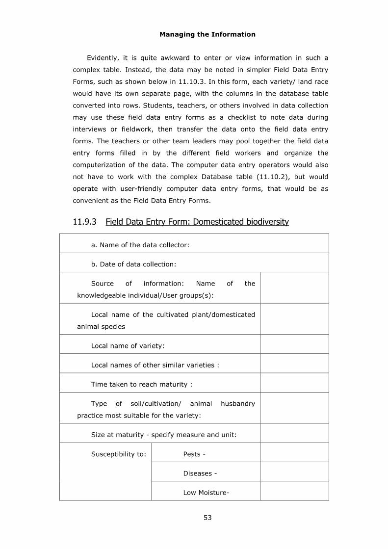
Managing the Information
53
Evidently, it is quite awkward to enter or view information in such a
complex table. Instead, the data may be noted in simpler Field Data Entry
Forms, such as shown below in 11.10.3. In this form, each variety/ land race
would have its own separate page, with the columns in the database table
converted into rows. Students, teachers, or others involved in data collection
may use these field data entry forms as a checklist to note data during
interviews or fieldwork, then transfer the data onto the field data entry
forms. The teachers or other team leaders may pool together the field data
entry forms filled in by the different field workers and organize the
computerization of the data. The computer data entry operators would also
not have to work with the complex Database table (11.10.2), but would
operate with user-friendly computer data entry forms, that would be as
convenient as the Field Data Entry Forms.
11.9.3 Field Data Entry Form: Domesticated biodiversity
a. Name of the data collector:
b. Date of data collection:
Source of information: Name of the
knowledgeable individual/User groups(s):
Local name of the cultivated plant/domesticated
animal species
Local name of variety:
Local names of other similar varieties :
Time taken to reach maturity :
Type of soil/cultivation/ animal husbandry
practice most suitable for the variety:
Size at maturity - specify measure and unit:
Pests -
Diseases -
Susceptibility to:
Low Moisture-
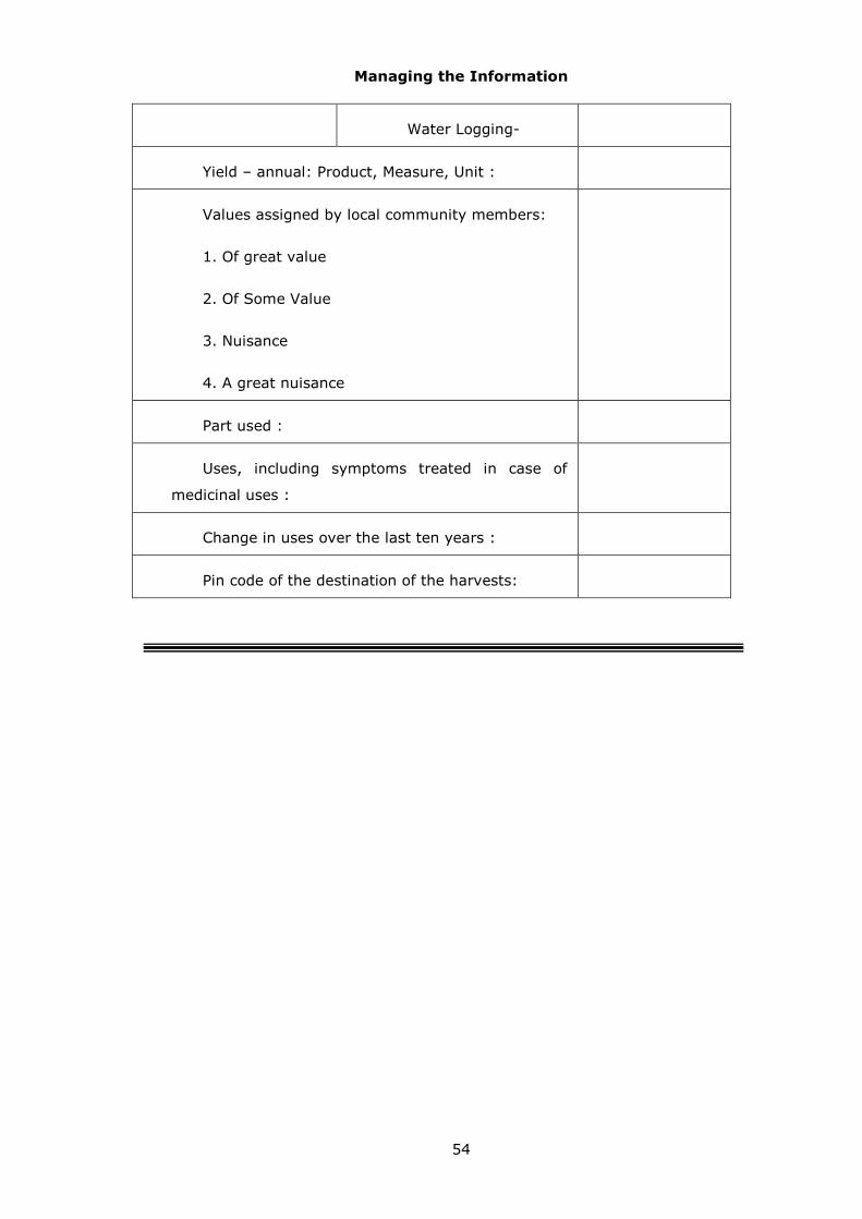
Managing the Information
54
Water Logging-
Yield – annual: Product, Measure, Unit :
Values assigned by local community members:
1. Of great value
2. Of Some Value
3. Nuisance
4. A great nuisance
Part used :
Uses, including symptoms treated in case of
medicinal uses :
Change in uses over the last ten years :
Pin code of the destination of the harvests:

Themes and Methods
55
12 Themes and Methods
12.1 Activity flow
t is helpful to organize data collection in a sequence that would facilitate
a smooth flow of activities. Thus it is appropriate to map the ecological
habitats and make a species list, before selecting particular habitat
patches to record the abundance of different species of plants. We therefore
propose collection of data in a series of 16 steps. These have been assigned
to two levels of investigation: mid-level (M), or advanced (A). The extensive
PBR preparation initiated by the Madhya Pradesh Biodiversity Board in 2005
follows the mid-level approach. The ongoing pilot studies through the Indian
Institute of Science follow the advanced approach. The main difference is
that the advanced approach calls for some field observations to complement
the primarily interview based mid-level approach. The data being collected in
each step may be recorded systematically using one or more field data entry
forms, and we indicate M = mid-level or A = advanced, against each form.
Box 12.1.1 provides an overview of the proposed steps, sources of
information, and the relevant forms.
♦♦♦♦♦♦♦♦♦♦♦♦♦♦♦♦♦♦♦♦♦♦♦♦♦♦♦♦♦♦♦♦♦♦♦♦♦♦♦♦♦♦♦♦♦♦♦♦♦♦♦♦
Box: 12.1.1 Activities stream and proposed data entry forms
0. Specifying the study team and site
Form 0. Study team and study sites {M}
↓ 1. Listing of activities linked to natural resources
(Group discussions)
Form 1.1: Activities of local people {A}
Form 1.2: Activities of outsiders {A}
↓ 2. Delineation and documentation of user groups: local and external
(Group discussions)
Form 2.1: Local user groups {M}
Form 2.2: External user groups {M}
Form 2.3: Drivers and impact of (Local / External) user groups {A}
Form 2.4: Recording movements of nomadic groups {A}
↓ 3. Identification of knowledgeable individuals
(Group discussions)
Form 3.1: Knowledgeable individuals- local {M}
I

Themes and Methods
56
Form 3.2: Knowledgeable individuals- external {M}
↓ 4. Listing of landscape/ waterscape element types and sub-types, participatory
mapping and recording of code numbers of significant elements indicated on the map
(Group discussions)
Form 4.1: LSE/ WSE types and subtypes {M}
Participatory map {M}
↓ 5. Inventory of locally available life forms known to local community members, and
listing of focal taxa selected for further documentation
(Group discussions)
Form 5.1: Locally known life-forms {M}
↓ 6. Listing of functional species groups (e.g. fuel-wood, edible fish) selected for
further documentation
(Group discussions)
Form 6.1: Functional species- groups {A}
↓ 7. Documentation of the setting of the study site
(Group discussions, study of documents, field observations)
Form 7.1a: Background information - 1{M}
Form 7.1b: Background information - 2{M}
Form 7.1c: Background information - 3{M}
Form 7.1d: Background information - 4{M}
Form 7.2: Historical and cultural information {M}
↓ 8. Documentation of issues that local community members would like to serve as the
focus of the PBR exercise, and the associated taxa, functional species groups and
landscape/ waterscape elements
(Group discussions)
Form 8.1: Key concerns {M}
↓ 9. Documentation of status, dynamics, and management issues relating to various
landscape/ waterscape element types/ sub-types considered as a whole
(Group discussions)
Form 9.1a: Landscape status and dynamics {M}
Form 9.1b: Landscape management {M}
Form 9.2a: Waterscape status and dynamics {M}
Form 9.2b: Waterscape management {M}
↓ 10. Documentation of status, dynamics, and management issues relating to various
focal landscape/ waterscape elements selected for further documentation
(Field observations)
Form 10.1: Focal landscape elements field survey {A}
Form 10.2: Focal landscape elements vegetation cover {A}
Form 10.3: Focal waterscape elements field survey {A}
Form 10.4: Focal waterscape elements sampling studies {A}
↓ 11. Documentation of status, dynamics and management issues relating to various
focal landscape/ waterscape elements selected for further documentation

Themes and Methods
57
(Group discussions)
Form 11.1a: Focal landscape elements history {M}
Form 11.1b: Focal landscape elements management {M}
Form 11.2a: Focal waterscape elements history {M}
Form 11.2b: Focal waterscape elements management {M}
↓ 12. Documentation of status of various focal taxa and species groups in focal
landscape/ waterscape elements
(Field observations: in conjunction with step 10)
Form 12.1: Focal taxa abundance field survey {A}
↓ 13. Documentation of status, dynamics and management issues relating to various
focal taxa and species groups selected for further documentation
(Group discussions)
Form 13.1: Focal taxa status & trends in abundance {M}
Form 13.2: Domesticated biodiversity {M}
Form 13.3: Focal taxa status & trends in value/ uses {M}
Form 13.4a: Focal taxa status & trends in management {M}
Form 13.4b: Focal taxa management user group perspectives {M}
↓ 14. Documentation of people’s knowledge relating to various ecological habitats and
focal taxa and species groups selected for further documentation
(Group discussions)
Form 14.1: Folk knowledge of population ecology, life history and behaviour {A}
↓
15. Designing components of management plan
(Group discussions, discussions involving the entire village/ ward assembly)
Form 15.1 Components of management plan {M}
♦♦♦♦♦♦♦♦♦♦♦♦♦♦♦♦♦♦♦♦♦♦♦♦♦♦♦♦♦♦♦♦♦♦♦♦♦♦♦♦♦♦♦♦♦♦♦♦♦♦♦♦
Of course, these are only broad guidelines; the steps should not be
thought of as a strict linear sequence, wherein one-step must be completed
before activity on any further steps can be initiated. Several of the activities
can indeed proceed in parallel. Thus, one may list the known life forms side
by side with preparing an inventory of the landscape element types and sub-
types, and recording historical and cultural information about the study site,
and so on. The total amount of effort put in can also be adjusted by deciding
to focus on fewer or more species, fewer or more habitat patches, i.e.
landscape/ waterscape elements, and so on.

Themes and Methods
58
12.2 Study methods
The PBR documentation would focus on the following elements:
� People- natural resource links,
� Landscape/ waterscape of the study area,
� Local biodiversity elements,
� People’s knowledge associated with biodiversity,
� People’s perspectives on management issues,
Culminating in the formulation of a:
� Management plan to support the functioning of the local
Biodiversity Management Committee.
As noted in sec. 11.10, this documentation would be based on the
following sources of information:
� Interviews of knowledgeable individuals, for instance, of
changes in the availability of a certain fish species in the
locality;
� Group interviews, for instance, as to who are the gainers
and losers of a particular regime of management, for
example, construction of a barrage on a backwater;
� Discussions involving the entire village/ ward assembly,
eg., on the components of the management plan
� Field observations, for instance, of occurrence of certain
weeds infesting grazing lands, or the level of pollutants at a
particular sampling location in a stream;
� Official documents, for instance, as to the obligations of
mine owner to revegetate abandoned mines.

Themes and Methods
59
12.2.1 People- natural resource links
India still remains a biomass based civilization and the quality of life of a
significant fraction of our people directly depends on access to products and
services of surrounding ecosystems, many of them grounded in biodiversity.
These may be both positive and negative, goods and bads, services and
disservices. A number of forms, therefore, record ecosystem goods and
services, as also bads and disservices (forms 9.1a, 9.2a, 11.1a, 11.2a,
13.4a).
Ecosystem Goods and Services
What then are these goods, services, bads and disservices? Ecosystem
goods and services may be visualized as “those goods and services which
undergo relatively little change in the hands of people; in other words,
conversion from the form in which it is provided by nature to the form in
which it can be used by people involves relatively little capital investment.”
Ecosystem goods and services could be available as a result of human
modifications of ecosystems, such as agriculture or plantations with chemical
pesticides as an input, or could be more direct gifts of nature such as wild
fruit or fishes. It may require significant and arduous human effort to access
certain ecosystem goods such as wild honey or toddy but the form in which
they are tapped from nature would usually be directly of use to humans
without the need of any capital-intensive transformation. We may also
include in this category simple products that are results of local value-
addition not involving any major external input, such as baskets and brooms,
since these products involve strong links of local people with their
ecosystem. Ecosystems bads and disservices are the converse of these,
results of natural processes that are undesirable from the perspectives of
some human groups.
We may illustrate these definitions with some concrete examples of
ecosystem versus industrial goods/ bads and services/disservices:
Ecosystem Industrial
Goods Locally available medicinal herb (Relatively little transformation, no well-defined market, labour-intensive collection process)
Commercially produced drug capsule (High degree of transformation, well-defined market, capital-intensive production process)
Service
s
Pest control by natural predators.
Pest control by application of chemical pesticides

Themes and Methods
60
Ecosystem Industrial
Bads Pests, disease vectors, pathogens
Persistent organic pollutants such as DDT
Disservices Landslides, floods, tsunamis
Destruction of atmospheric ozone layer as a result of emission of CFCs from refrigeration processes
Goods/ bads and services/ disservices are defined with respect to their
use-values to an individual, a group of individuals or a community. In almost
every case, many of the ecosystem goods and services of an area are used
by people living outside. They may access these through the market (e.g. a
marketed NTFP such as Garcinia fruit), by virtue of locational advantages
(e.g. watershed benefits in downstream areas) or by physically accessing the
ecosystem (e.g. collecting firewood or enjoying scenic beauty). There would
also be certain ecosystem goods and services which yield benefits to a much
larger community (beyond those with access through the above means).
Forests, for example, provide benefits through fixing carbon to the global
community at large with impacts potentially reaching a small island nation or
a low lying delta facing threats of submergence thousands of kms away.
These benefits will typically have no significance for the local people. We
provide below an indicative list of ecosystem goods/bads and services/
disservices, as perceived by various groups of local people of Mala cluster
study site.
Table. Examples of ecosystem goods as
reported by people of Mala
Ecosystem goods Use Locally used
Marketed
Oryza sativa (Paddy ) Food * Bamboo shoots Food * Crop waste Fuel * Cane Basket-making * Amla Pickles * Teak Timber * Ratsnake Pest control * Honey bee Honey * Water Irrigation,
domestic uses, fishing
*
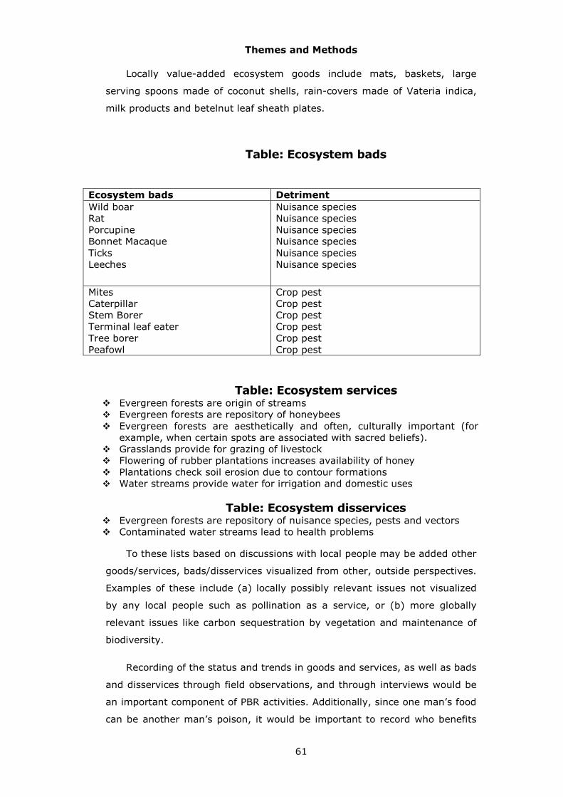
Themes and Methods
61
Locally value-added ecosystem goods include mats, baskets, large
serving spoons made of coconut shells, rain-covers made of Vateria indica,
milk products and betelnut leaf sheath plates.
Table: Ecosystem bads
Ecosystem bads Detriment
Wild boar Rat Porcupine Bonnet Macaque Ticks Leeches
Nuisance species Nuisance species Nuisance species Nuisance species Nuisance species Nuisance species
Mites Caterpillar Stem Borer Terminal leaf eater Tree borer Peafowl
Crop pest Crop pest Crop pest Crop pest Crop pest Crop pest
Table: Ecosystem services � Evergreen forests are origin of streams � Evergreen forests are repository of honeybees � Evergreen forests are aesthetically and often, culturally important (for
example, when certain spots are associated with sacred beliefs). � Grasslands provide for grazing of livestock � Flowering of rubber plantations increases availability of honey � Plantations check soil erosion due to contour formations � Water streams provide water for irrigation and domestic uses
Table: Ecosystem disservices � Evergreen forests are repository of nuisance species, pests and vectors � Contaminated water streams lead to health problems
To these lists based on discussions with local people may be added other
goods/services, bads/disservices visualized from other, outside perspectives.
Examples of these include (a) locally possibly relevant issues not visualized
by any local people such as pollination as a service, or (b) more globally
relevant issues like carbon sequestration by vegetation and maintenance of
biodiversity.
Recording of the status and trends in goods and services, as well as bads
and disservices through field observations, and through interviews would be
an important component of PBR activities. Additionally, since one man’s food
can be another man’s poison, it would be important to record who benefits

Themes and Methods
62
and who loses from the various goods and services, and bads and
disservices. Thus, wild pigs may be a bad for members of the user group
whose livelihood depends crucially on cultivation, but for the user group
comprising landless labourers, the pigs may represent a valued food
resource.
Human activities
Humans are the most significant agents affecting the natural resource
base and recording their on-going activities, as well as changes over the
recent past would be a part of the documentation process (forms 10.1,
10.3). This documentation would have to be based on interviews, in
particular in the context of trends over time, and supplemented by such field
observations as are possible. The activities may be classified into three
categories:
� Harvests, removals: For example, of plant material, such as of
fuelwood, or, grass through grazing by cattle, of stones through
quarrying, or, of water by pumping from rivers for irrigation.
� Additions: For example, application of leaf manure or chemical fertilizers
to orchards, or of sewage from towns to river waters.
� Modifications: For example, leveling of a hill slope by bulldozing, or
damming of a stream by bunds.
12.2.2 Landscape and biodiversity
Physical and biological parameters
In the context of landscape and biodiversity elements, the field
observations as well as interviews would deal with a number of topics. These
would include a whole set of (a) physical parameters such as extent of area,
topography, nature of bottom substrate and depth of water in water-bodies,
or distance from habitation, and (b) biological parameters such as
occurrence of particular species, level of abundance of a particular functional
species group such as fodder species or identity of neighbouring landscape/
waterscape element types. The data on current status would be largely
based on actual field observations (forms 10.1, 10.2, 10.3, 10.4, 12.1).
However, the data on trends would have to be based on interviews of
knowledgeable individuals in the absence any earlier records (forms 9.1a,
9.2a, 11.1a, 11.2a, 13.1a). People tend to have a very good recollection of

Themes and Methods
63
changes that have occurred over the last ten years. So trends would be
recorded over this time-scale. Since this is subjective recall, it would be
appropriate to interview at least a few persons, either individually, or, in a
group, to arrive at a broad consensus. The investigator recording data should
satisfy herself/ himself that the information appears reliable before recording
it.
Selection of sample points: on land
Field observations of particular ecological habitats, or, elements of the
landscape /waterscape, chosen for more detailed study would require
identification of certain sampling points (forms 10.2, 10.4). It is important
that these sampling points be selected at random, without any bias. For
instance, the extent of plant cover on any land habitat is an important
attribute of that patch. The points at which the plant cover is sampled should
therefore be selected in an unbiased fashion. Thus, in a patch with little tree
cover, one should not deliberately select a clump of trees as a sampling
point. While we need to avoid any such bias, the procedure also needs to be
simple enough to be implemented by teachers, students and other
volunteers. We, therefore suggest a procedure that does not call for any
equipment or accessories such as tables of random numbers. Figures
12.2.2.3, 12.2.2.5, and 12.2.2.6 provide illustrations of the use of these
procedures in case of a land habitat, a pond/ lake or a river/stream,
respectively.
In case of a land habitat, the procedure would involve the following
steps:
� Locate the northern-most point of the element. Using a compass, start pacing due south in a straight line, use the points at 20, 40, 60, 80 and 100 paces as sampling points. If one comes out of the patch before completing the 5 sampling points, use as many as available. These points are labeled S1, S2, S3, S4, and S5 in figure 12.2.2.3.
� Locate the eastern-most point of the element. Using a compass, start pacing due west in a straight line, use the points at 20, 40, 60, 80 and 100 paces as sampling points. If one comes out of the patch before completing the 5 sampling points, use as many as available. These points are labeled W1, W2, W3, and W4 in figure 12.2.2.3.
� Locate the southern-most point of the element. Using a compass, start pacing due north in a straight line, use the points at 20, 40, 60, 80 and 100 paces as sampling points. If one comes out of the patch before completing the 5 sampling points, use as many as available. These points are labeled N1, N2, N3, N4, and N5 in figure 12.2.2.3.
� Locate the western-most point of the element. Using a compass, start pacing due east in a straight line, use the points at 20, 40, 60, 80 and 100

Themes and Methods
64
paces as sampling points. If one comes out of the patch before completing the 5 sampling points, use as many as available. These points are labeled E1, E2, E3, E4, and E5 in figure 12.2.2.3.
If this exercise does not yield 20 sample points, use the midpoints
between available sampling points as additional sample points. Thus, if the
exercise has provided 19 sample points then use an additional point at 90
paces walking due east in a straight line from the western-most point of the
landscape element being sampled. This point is labeled W5 in figure
12.2.2.3.
In the process of locating these sampling points the walk may take one
straight into a thick clump of thorny bushes, or if studying an area of human
habitation, inside a building. In these cases, one may estimate where the
sampling points are, without actually trying to reach them. The primary
purpose of this procedure is to ensure that the 20 sampling points are
selected in an unbiased fashion. So the procedure need not be followed
rigidly. In case of a very large patch, for instance, it may not be easy to
reach all four extremes. Some parts of the patch may be inaccessible. In
such cases, one may make some small changes in the procedure.
Diagram 4: A diagrammatic representation of sampling procedure in a
habitat patch on land, in this case, a patch of scrub.

Themes and Methods
65
The sampling points have been selected to assess the level of plant
cover. Therefore, at each sampling point, note whether that point is under a
tree canopy, covered by a shrub, with herbaceous vegetation, on barren
land, on paved land, or inside a building (Form 10.2). As will be elaborated
below, this field sampling may be combined with observations on the
abundance of focal species, varieties, or functional species groups in the
elements under survey.
Selection of sample points: water-bodies
Sampling is a little more complex affair in case of water bodies. An
important issue is the time of sampling. Ideally, one may sample twice a
year; once when the availability of the water is at its peak, and the second,
when it is at its lowest.
In the case of a lake or a pond, one may follow a procedure analogous to
that suggested for land habitats (Figure 12.2.2.5). Thus:
� Locate the northern-most point of the water-body. Walk along the edge of the water-body towards the south in an easterly direction, using the points at 20, 40, 60, 80 and 100 paces as sampling points. These points are labeled S1, S2, S3, S4, and S5 in figure 12.2.2.5.
� Locate the eastern-most point of the water-body, unless one has already overshot this point while selecting the earlier sampling points. In that case, use the last sampling point reached as the starting point. Walk along the edge of the water-body towards the west in a southerly direction, using the points at 20, 40, 60, 80 and 100 paces as sampling points. These points are labeled W1, W2, W3, W4, and W5 in figure 12.2.2.5.
� Locate the southern-most point of the element, unless one has already overshot this point while selecting the earlier sampling points. In that case, use the last sampling point reached as the starting point. Walk along the edge of the water-body towards the north in a westerly direction, using the points at 20, 40, 60, 80 and 100 paces as sampling points. These points are labeled N1, N2, N3, N4, and N5 in figure 12.2.2.5.
� Locate the western-most point of the element, unless one has already overshot this point while selecting the earlier sampling points. In that case, use the last sampling point reached as the starting point. Walk along the edge of the water-body towards the east in a northerly direction, using the points at 20, 40, 60, 80 and 100 paces as sampling points. These points are labeled E1, E2, E3, E4, and E5 in figure 12.2.2.5.
This procedure requires that the circumference of the water body should
be at least 400 paces to yield 20 sampling points. If the water body is
smaller than this, then midpoints between available sampling points may be
used as additional sample points. Where practicable, one might use a row
boat/ sail boat/ motor boat with the help of local fishermen, and
imaginatively work out a scheme of sampling open waters.

Themes and Methods
66
Diagram 5: A diagrammatic
representation of sampling procedure in case of a lake
In case of a linear water-element such as a stream or a river, or sea
coast, one may initiate sampling at a point where the stream, or the beach,
is at its widest within the limits of the sampling locality (Fig.12.2.2.6). One
may then walk along the edge of the water in either direction, using points at
20, 40, 60, 80, 100, 120, 140, 160, 180 and 200 paces as the sampling
points. These have been labeled as U1, U2, U3, U4, U5, U6, U7, U8, U9, and
U10 while moving upstream, and D1, D2, D3, D4, D5, D6, D7, D8, D9, and
D10, while moving downstream. If this exercise does not yield 20 sample
points, one may use the midpoints between available sampling points as

Themes and Methods
67
additional sample points. This has been indicated in form of D6, D7, D8, D9,
and D10 being situated as midpoints in Fig. 12.2.2.6.
Diagram 6: A diagrammatic
representation of sampling procedure in case of a river.
Where practicable, on lakes, rivers or sea, one might use a row boat/
sail boat/ motor boat with the help of local fishermen, and imaginatively
work out a scheme of sampling open waters.
12.2.3 Management
Preparation of a well-informed management plan with a broad support of
all segments of the community to promote conservation, sustainable use and

Themes and Methods
68
equitable sharing of benefits flowing from biodiversity is an important
objective of the PBR exercise. Collection of pertinent information on
management of habitats as well as species is therefore a significant element
of the investigation. This information would be collected partly through field
observations, but largely based on interviews. Since different segments of
the population may have different perspectives on management issues, it
would be appropriate to get their inputs through group discussions involving
members of one user group at a time. Since these are matters of judgment,
the investigator must be satisfied that there is a consensus within the group.
Moreover, the investigator must ensure that she/he remains neutral and
faithfully records the perceptions of the people being interviewed, rather
than introduce her/his own biases.
Information on management would relate to (a) current management,
as well as (b) experiences of management in recent past. Thus, a forest
patch may have been managed earlier as a reserved forest, and may now be
being managed under joint forest management regime. It would be useful to
record the experiences of both the regimes. This should be followed by
documentation of what members of any particular group want to see happen
in future, and what changes they would like to see happen. They may then
be requested to elaborate their own vision of a desirable management
system. A number of different elements would be involved in this vision.
These may relate to (a) rights of access to land, waters or biological
resources, (b) roles of different governmental agencies, private industry,
landowners or community institutions, (c) local versus outside actors, (d)
technologies employed, and (e) access to capital or markets, and so on. It
would be worthwhile to encourage the community members to give full scope
to their imagination and come up with a variety of innovative solutions. But
finally, it is important to examine ground realities, and the community
members may be invited to shift from what they would ideally like to see
happen to suggesting elements of a management plan that can be
implemented under present circumstances and for which a consensus of the
gram sabha seems feasible. Different user groups may come up with a range
of such plans. They may then be put before the gram sabha as reflections of
the many different perspectives of the different user groups, local and
external, to arrive at its own set of recommendations. Hopefully, there would
be more and more space in the coming years for such a people-oriented
mode of planning to play a significant role in the management of India’s rich
heritage of biological diversity.

Themes and Methods
69
12.2.4 Knowledge
The rules gazetted under the Biological Diversity Act state that PBR shall
contain comprehensive information on availability and knowledge of local
biological resources, their medicinal or any other use or any other traditional
knowledge associated with them. This knowledge would be documented
essentially on the basis of interviews, especially of knowledgeable
individuals. At this stage, we do not have in place a proper framework for
managing information that people might wish to keep confidential (section
5.5). So the documentation may, for the present, be limited to those aspects
of knowledge that people are happy to share widely. This may include much
of their practical ecological knowledge, but only a part of their knowledge of
medicinal and other uses.

Peoplescape
70
13 Peoplescape
13.1 User groups
he PBR process may ideally begin with the local Biodiversity
Management Committee establishing a Study Group to organize the
preparation of the PBR. This Study Group may initiate the work by
bringing together community members and teachers and students to explore
possible uses of information generated through a PBR exercise (appendix 1).
In practice, this initiating group is likely to be relatively small, often
dominated by the wealthier, more educated men. This would tend to exclude
community members who are more closely tied to and more knowledgeable
about biodiversity. This is because members from poorer households, often
women, are perforce more dependent on activities such as basket-weaving,
sale of fuel-wood, or fishing. Yet, it is very important that the PBR exercises
bring on board people linked in many different ways to the resources of their
environment.
To help create a broad-based team, the community members may be
assigned to a number of User Groups (Diagram 7). Each User Group may be
viewed as comprising people with a similar relationship to their ecological
resource base, differing, in some significant manner from that of members
assigned to other user groups. Table 13.1.1 provides a framework for
naming the various user groups living in a locality, as well as impinging on it
from outside.
T

Peoplescape
71
13.1.1 Standard categories of User Groups and Sub-groups
defined on basis of most significant source of livelihood in
case of households, or revenue in case of institutions.
Additional categories of User Sub-groups may be added as
appropriate in any locality.
Co
de
#
Short
title of
user
group
Most significant
source of
livelihood or
revenue
Cod
e #
Concatenat
ed short
title of user
sub-groups
Most
significant
source of
livelihood
or revenue
Exam
ples
of
instit
ution
s
1.1 Gatherer -fuelwood
Collection of fuel-wood
1.2 Gatherer -MFP
Collection of minor forest produce
1.3 Gatherer -medicinals
Collection of medicinal herbs
1 Gatherer Gathering of naturally produced land-based living resources
1.4 Gatherer -Game
Hunting of small birds and mammals like partridges and hare or snakes
2.1 Freshwater fisher -Shellfish
Collection of shellfish like mussels and snails
2.2 Freshwater fisher -Shallow
Fishing in shallow waters without a boat
2 Freshwater fisher
Gathering of naturally produced freshwater living resources
2.3 Freshwater fisher -Boatman
Fishing in deeper waters using a boat
3.1 Sea fisher –Shellfish
Collection of shellfish like mussels and snails
3.2 Sea fisher -Country craft
Fishing in sea using country craft
3.3 Sea fisher -Motor boat
Owner of mechanized fishing craft/s
Trawling company
3 Sea fisher
Gathering of naturally produced marine/ estuarine living resources
3.4 Sea fisher -Worker
Working on mechanized fishing craft as employee
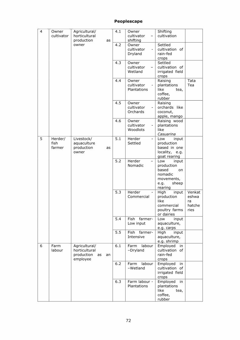
Peoplescape
72
4.1 Owner cultivator –shifting
Shifting cultivation
4.2 Owner cultivator -Dryland
Settled cultivation of rain-fed crops
4.3 Owner cultivator –Wetland
Settled cultivation of irrigated field crops
4.4 Owner cultivator -Plantations
Raising plantations like tea, coffee, rubber
Tata Tea
4.5 Owner cultivator -Orchards
Raising orchards like coconut, apple, mango
4 Owner cultivator
Agricultural/ horticultural production as owner
4.6 Owner cultivator -Woodlots
Raising wood plantations like Casuarina
5.1 Herder -Settled
Low input production based in one locality, e.g. goat rearing
5.2 Herder –Nomadic
Low input production based on nomadic movements, e.g. sheep rearing
5.3 Herder -Commercial
High input production like commercial poultry farms or dairies
Venkateshwara hatcheries
5.4 Fish farmer-Low input
Low input aquaculture, e.g. carps
5 Herder/ fish farmer
Livestock/ aquaculture production as owner
5.5 Fish farmer-Intensive
High input aquaculture, e.g. shrimp
6.1 Farm labour –Dryland
Employed in cultivation of rain-fed crops
6.2 Farm labour –Wetland
Employed in cultivation of irrigated field crops
6 Farm labour
Agricultural/ horticultural production as an employee
6.3 Farm labour -Plantations
Employed in plantations like tea, coffee, rubber

Peoplescape
73
6.4 Farm labour -Orchards
Employed in orchards like coconut, apple, mango
7.1 Herd labour –Nomadic
Employed in nomadic livestock production
7.2 Herd labour -Settled
Employed in settled livestock production
7 Herd/pond labour
Livestock/ aquaculture production as an employee
7.3 Pond labour Employed in aquaculture
8.1 Bioprocessor –Cottage
Processing/ manufacture in cottage industries sector, e.g. tapping toddy, or making leaf cups or pickles or khowa at home
8 Bioprocessor
Living resource based processing/manufacture as owner
8.2 Bioprocessor –Industry
Processing/ manufacture in industrial sector, pharmaceutical industry
Pravaranagar Co-operative Sugar Factory
9.1 Bioprocessing worker –Cottage
Employed in cottage industries sector, e.g. rolling beedies
9 Bioprocessing worker
Living resource based processing/manufacture as an employee
9.2 Bioprocessing worker –Industry
Employed in industrial sector, e.g. saw mill or an oil mill
10.1
Biotrader -Small scale
Trade in unorganized sector, e.g. retail sale of fish or vegetables
10 Biotrader Living resource based trade as owner
10.2
Biotrader -Organized
Trade in organized sector, e.g. wholesale trade in food grains or wooden furniture
ITC agro-business division
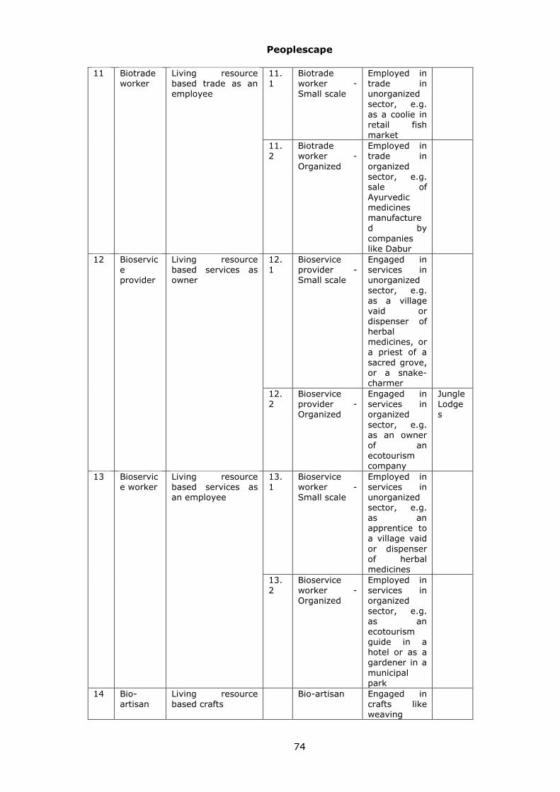
Peoplescape
74
11.1
Biotrade worker -Small scale
Employed in trade in unorganized sector, e.g. as a coolie in retail fish market
11 Biotrade worker
Living resource based trade as an employee
11.2
Biotrade worker -Organized
Employed in trade in organized sector, e.g. sale of Ayurvedic medicines manufactured by companies like Dabur
12.1
Bioservice provider -Small scale
Engaged in services in unorganized sector, e.g. as a village vaid or dispenser of herbal medicines, or a priest of a sacred grove, or a snake-charmer
12 Bioservice provider
Living resource based services as owner
12.2
Bioservice provider -Organized
Engaged in services in organized sector, e.g. as an owner of an ecotourism company
Jungle Lodges
13.1
Bioservice worker -Small scale
Employed in services in unorganized sector, e.g. as an apprentice to a village vaid or dispenser of herbal medicines
13 Bioservice worker
Living resource based services as an employee
13.2
Bioservice worker -Organized
Employed in services in organized sector, e.g. as an ecotourism guide in a hotel or as a gardener in a municipal park
14 Bio-artisan
Living resource based crafts
Bio-artisan Engaged in crafts like weaving

Peoplescape
75
baskets or mats
15.1
Bioresource manager -Regulation
Engaged in regulatory activities, e.g. as employees of Forest Department
Forest Development Corporation
15 Bioresource manager
Government employee engaged in controlling/ managing living resources
15.2
Bioresource manager -Extension
Engaged in extension activities, e.g. as employees of Agriculture Department
16.1
Unorganized worker -Conservator
Engaged in living resource conservation activities, e.g. as a Bishnoi protecting Khejadi trees or blackbuck
16 Unorganized worker
Non-living resource based livelihoods in unorganized sector
16.2
Unorganized worker -Indifferent
Without any involvement in living resource conservation activities
17.1
Organized worker -Conservator
Engaged in living resource conservation activities, e.g. lobbying for conservation of a city lake or opposing building activities on a city hill
Bombay Natural History Society
17.2
Organized worker -Indifferent
Without any involvement in living resource conservation activities
17 Organized worker
Non-living resource based livelihoods in organized sector
17.3
Organized worker- tourist
Visiting as a tourist

Peoplescape
76
18.1
Adverse enterprise –State
Government State enterprises such as hydroelectric projects or cities discharging untreated sewage into lakes
18 Adverse enterprise
Institutions whose side effects impact living resources negatively
18.2
Adverse enterprise –Private
Private Private enterprises such as quarries or industries generating chemical effluents
Thus in village Masur-Lukkeri situated on an island in the estuary of
Aghanashini river in Uttara Kannada district of Karnataka we may visualize
four user groups:
[a] The first user group includes people who own no farm land with men
primarily engaged in fishing, and women in sale of these fish and collection
and sale of shellfish. These may be assigned to one of the following three
standard categories: Freshwater fisher –Shellfish, Freshwater fisher –
Shallow, or Freshwater fisher –Boatman. The exact assignment would
depend on the relative contribution of these three ways of earning
livelihoods, in this case, we assign them to: Freshwater fisher –Boatman.
[b] The second user group includes people who own a limited amount of
hill slope land where they cultivate upland paddy, the women engage
extensively in collection of shellfish and weaving mats, and both men and
women engage in casual labour. These may be assigned to one of the
following four standard categories: Freshwater fisher –Shellfish, Owner

Peoplescape
77
cultivator –Wetland, Bio-artisan and Unorganized worker –Indifferent. Based
on dominant mode of earning livelihood, we assign them to: Unorganized
worker –Indifferent.
[c] The third user group includes people who own estuarine farmland
where they raise brackish water paddy or culture shrimp, the women weave
mats and men engage in casual labour and work as masons. These may be
assigned to one of the following four standard categories: Owner cultivator –
Wetland, Fish farmer- Low input, Bio-artisan and Unorganized worker –
Indifferent. Based on dominant mode of earning livelihood, we assign them
to: Fish farmer- Low input.
[d] The fourth user group includes people who own bigger chunks of
plain land where they grow coconut, arecanut and pepper. They may be
easily assigned to: Owner cultivator –Orchards.
Members of different user groups may exhibit overlaps in their activities;
thus women from groups [a] and [b] collect shellfish, and those from groups
[b] and [c] weave mats. Members of any one group may also be linked to a
variety of living resources. Thus members of group [b] are not only engaged
in cultivation, shellfish collection and mat weaving but also in collection of
fuel wood and leaf mulch, occasional hunting of hare and wild pigs and a
variety of other activities. Besides the women in a group may differ
substantially from men in their relationship to natural resources.
Nevertheless, the user groups have been so delineated that variation across
groups is much greater than within groups. As a result, the concept of user
groups represents a constructive way of assigning people to different
categories to ensure that people with varying relationship to natural
resources are represented in the PBR exercise. While there is some
correspondence between ethnic communities and user groups, our concern is
with the relationship of people with natural resources and not caste or other
ethnic composition. Of course, it would be highly desirable to involve both
men and women from each group in the PBR activities.

Peoplescape
78
People, institutions
KnowledgeInvestigations Activities
User groupsRole in investigations
possessParticipate in
undertake
Outsiders NomadicLocal
Defines
Constitute
Diagram 7: Schematic representation of sub-classes of entities of “People, institutions”
class and their major relationships to other types of entities.
13.1.2 External User Groups
The area within the jurisdiction of the Panchayat (or Municipality) is, of
course, not immune to outside influences. A factory or town upstream may
be profoundly impacting the water and fish resources of a river passing
through the locality (Adverse enterprise -Private). Similarly people from
neighbouring villages may be drawing on its resources for fuel wood or
fodder (Gatherer –fuelwood, Herder -Settled). Or nomadic herders may
annually visit the area and penning their sheep in agricultural fields supply
valuable manure (Herder -Nomadic). The activities and interests of all these
concerned external parties must be taken into account in planning for
prudent management of living resources within the jurisdiction of any local
body. An important task of the study team should therefore be to delineate
such external user groups. These too may be named using the framework of
Table 13.1.1 as indicated in brackets above.
13.1.3 Urban User Groups
In an urban setting the way people relate to ecosystem resources may
be substantially different. Thus in the city of Pune in Maharashtra, a small

Peoplescape
79
proportion of the people, for example, tribal Katkaris are still largely
dependent on fishing and hunting of birds around the river courses for their
livelihood (Gatherer-game, Freshwater fisher-shallow). Similarly, nomadic
shepherds visit hills of Pune during monsoon months and graze their sheep
and goats there for several weeks (Herder-nomadic). A somewhat larger
number of poorer people depend on roadside and garden trees for their fuel
energy (Gatherer-fuelwood). Others depend on shade of avenue trees to
carry out businesses like cycle repairs. These may have a stake in the
conservation of the avenue trees (Unorganized worker -Conservator).
Another group depends on trading biodiversity resources such as fish or
timber brought from outside (Biotrader –Organized, Biotrade worker -Small
scale, Biotrade worker –Organized). Yet others are involved in processing of
biodiversity resources such as medicinal plants (Bioprocessor –Industry,
Bioprocessing worker -Industry). But a large fraction of urban population is
not directly connected with biodiversity resources in terms of their
livelihoods, earning their incomes from other trade, manufacture or service
related activities (Organized worker –indifferent). A fraction of these people
relates to biodiversity resources of hills of the city through recreational
activities. They may significantly influence management of ecosystem
resources, for instance, by lobbying to prohibit house construction on the
hills (Organized worker -Conservator).
As mentioned in section 11.6, the standard categories of user sub-
groups provided as master data in the database are necessarily limited, and
local study coordinators may create additional user sub-group categories as
appropriate.
13.2 Data collection
13.2.1 Inventory of activities
The user groups are defined in terms of the activities that link people
and institutions to the natural resources of the study locality. Our concern is
both with local people, such as farmers, and local institutions, such as a
quarry or cashew processing factory, and outside people, such as villagers
from neighbourhood grazing their cattle in the study area and outside
institutions such as a distant paper mill that harvests bamboo from the study
locality. The data collection may therefore appropriately begin with an
inventory of activities of various members of the local community and of

Peoplescape
80
local institutions, with an emphasis on those that relate to the ecosystems
goods (e.g. fuel-wood) and services (e.g. scenic natural spots) as also bads
(e.g. weeds) and disservices (e.g. crop raiding by wild life), to be followed by
a similar inventory of the activities of outside agents impinging on the study
locality. However, we should also include broad categories of other activities,
not directly linked to biodiversity, yet significant to the livelihoods of the
various individuals and functioning of the various institutions.
For convenience, these activities may be classified under the following
14 categories:
1 Gathering of forest/shellfish produce
2 Fishing / Hunting
3 Agriculture
4 Animal husbandry
5 Labour in unorganized sector
6 Craft in unorganized sector
7 Service in unorganized sector
8 Trade in unorganized sector
9 Employment in organized sector
10 Service in organized sector
11 Manufacture in organized sector
12 Trade in organized sector
13 Seeking recreation / religious experience
14 Effluent generation.
Forms 1.1 and 1.2 in the Annexure (accompanying volume of illustrative
tables) provide an illustrative list of such activities for two of the study sites.
Alongside the activities we also note their seasonal incidence, and if the
activity is considered significant. This significance is to be attached, not from
the perspective of a third party, such as teachers, but from the perspective
of those engaging in that activity. For example, collection of mollusks from
streams may be significant as an important protein source to landless
labourers who engage in it, but not to others. Of course, this is a subjective
judgment for the landless labourers as well. Nevertheless, the list should be
prepared, to the extent possible, with their involvement. The overall list may

Peoplescape
81
be very exhaustive. The sub-set of significant activities from such a list
would be relevant in two contexts: [a] delineation of user groups, [b]
understanding of dynamics and management of ecological habitats.
13.2.2 Delineation of user groups
Our major interest lies in identifying a manageable number of local user
groups/ sub-groups, up to 10 or at most 15 per locality, and a similar
number of external user groups/ sub-groups, that represent varied ways in
which people (and institutions) relate to the ecological resources. These
would be named within the framework of Table 13.1.1, creating additional
sub-groups as appropriate for the locality. Assignment of people to user
groups/ sub-groups in this fashion would permit the constitution of a broad
based team of people to provide inputs to the PBR process. Identification of
such a set of user groups/ sub-groups, will be a matter of subjective
judgment arrived at through broad based group discussions. We may then
characterize the different internal and external user groups/ sub-groups on
the basis of their involvement in clusters of activities with high levels of
association with each other. Table 17.2.2.1 below provides an example for
four user groups of Mala village.
User groups & associated activities User group Owner
cultivator -Orchards
Farm labour -Orchards
Owner cultivator -Wetland
Associated activities
Rubber cultivation, Gardening,
Maintenance of chicken, Fishing, Service in unorganized sector, Sale of minor forest produce, Mining sand,
Priesthood, Collection of medicinal plants, Crop cultivation, Sale of medicinal plants
Forms 2.1 and 2.2 in the Annexure give examples of local, as well as
external user groups identified for some of the study sites. These Forms refer
to: (a) User Group Name: assigned on the basis of the most significant
source of livelihood/ revenue of the group, (b) Associated Significant
Activities: A list of the significant activities of the members of the concerned
user group, (c) Approximate number of individuals involved including
dependents, in case of households, or employees, in case of institutions, (d)
Languages spoken by members of the concerned user group.

Peoplescape
82
Since external as well as local user groups may act through
intermediaries, Form 2.3 attempts to dissect their influence at three levels.
Thus villagers from nighbouring localities grazing their own cattle are agents
acting for themselves; as is a Paper Mill causing water pollution. In such a
case, it is not necessary to enter information pertaining to them in Form 2.3.
On the other hand labourers harvesting bamboo may be field level agents
working for a primary driving agent, a paper mill, with a contractor engaged
by the mill serving as the middleman, and these relationships should be
documented through Form 2.3. This Form 2.3 refers to: (a) Local / External
User Group name, (b) Primary driving agent - who is primarily responsible
for the activity, (c) Middleman - who is responsible for execution of activity,
(c) Field level agent - who actually works on ground (d) Significant activities,
(e) Extent of Influence on ecosystem services, to be selected from high,
moderate, low or nil, and (f) Effect, to be selected from positive or negative.
The final step in this set of activities is to note some details of the
identified knowledgeable individuals from the different local and outsider
user groups, as indicated in 13.2.4.
Nomadic populations
Nomadic shepherds, traders, entertainers are significant actors on the
Indian ecological scene, often possessing special knowledge of ecological
habitats and biodiversity. Some like Gaddis of Himalayas or Narikuravans of
Tamilnadu have been traditionally nomadic. Others like duck-keepers of
South India are newly emergent nomadic groups derived from many
different communities. For the PBR exercises nomads will constitute local
user groups in their native localities where they are registered as voters.
Elsewhere, in localities that they visit during their movements / migrations,
nomads will constitute external user groups. It would be worthwhile to
collect some additional information for such nomadic groups as indicated in
Form 2.4. The data to be entered into this form should pertain only to the
particular band of nomads visiting the study locality. There is no intention to
record here information on other bands of the concerned nomadic
community.
The Form 2.4 refers to:

Peoplescape
83
1) Nomad type: (a) traditional nomadic / traditional semi-nomadic / newly
emerged, (b) Pastoral /non-pastoral. Here, pastoral implies involvement
in animal husbandry, as with nomadic shepherds, and non-pastoral, lack
of such involvement apart from maintenance of some pack animals like
donkeys, as in the case nomadic stone-workers.
2) Native place where registered as voters: *Village/Panchayat *PIN
*Taluk *Dist *State: Most nomadic populations have some base villages,
where they may stay in some seasons such as monsoon.
3) Community/ies: Communities may preferably be selected from those
are those listed in the enumeration of the “People of India” project of the
Anthropological Survey of India. Many, though not all, communities find a
mention in this standard list. If so listed, much other information on these
communities may be obtained from a series of books published through
this project. In case a PoI Community is not applicable, the local name of
the concerned community may be used.
4) Composition: *No of males and of females refers to the particular group
visiting the study locality.
It is suggested that further information on pattern of visits of this
particular group be collected. A time frame of ten years is appropriate, since
people have a good recollection of events over such a time-span. Form 2.4
suggests recording the broad pattern of visits over this period, noting:
5) Visits in last ten years: It is suggested that the most significant
localities used by the particular nomadic group for resource collection or
camping, while operating close to the study site, be listed, giving the
following details:
o PIN of the nearest Post Office,
o Name of the village & distance,
o Distance from habitation,
o Name of LSE of visit/stay as reported by members of nomadic
population. Here LSE refers to a Landscape Element(e.g. a
particular patch of grassland, or forest or other kind of ecological
habitats) frequented by the nomadic group.

Peoplescape
84
o Frequency of visits: Daily/weekly/fortnightly/monthly/bi-
monthly/quarterly/half-yearly/yearly/not regular
o Duration of stay in hours/days: From month/nakshatra; *To
month/nakshatra
o Significance of the locality for their sustenance
13.2.3 Special Nomadic Communities PBRs
Normally, PBRs will be focused on specific localities such as villages or
Panchayats, and the different groups of people are viewed as User Groups.
However, special PBRs may be developed with a focus on a particular
nomadic population. These special PBRs may be designed as composite PBRs
pertaining to all the localities significant to the livelihood of the different
bands of a particular nomadic population. Their activities may then be
documented as those of a Local User Group in the place where they are
registered as voters, and as an External User Group in a sample of localities
along their movement/ migration route.
13.2.4 Knowledgeable individuals
Not all people would be equally knowledgeable, nor would they be
equally interested in participating in the PBR exercise. It is also likely that
some of the most knowledgeable individuals would come from the poorest
households and be reluctant to speak out in a group. An important
advantage of the user group approach is that these poor and socially
disadvantaged people would tend to be assigned to some distinctive,
relatively homogenous user group where they would be better able to
contribute. Therefore the identification of user groups should be followed by
separate discussions, if possible independently, with men and women from
each user group to identify the most knowledgeable individuals- men and
women from each group. This should be followed by identification of
knowledgeable individuals from the external user groups as well. As many of
the local knowledgeable individuals as possible should then be inducted as
members of the PBR study panel along with interested teachers, students,
members of Community Based Organizations such as Youth Clubs or

Peoplescape
85
women’s Self Help Groups and concerned officials such as Panchayat
Secretary, Agricultural Assistant or Forest Guard.
It would also be desirable to involve, to the extent possible, some of the
knowledgeable individuals from external user groups in the PBR exercise,
where feasible as participants in the study team. Forms 3.1 and 3.2 provide
examples of the recording of information on knowledgeable individuals.
These forms refer to:
o Name
o Age group: below 20, 20-40, 40-60, above 60
o Sex: M/F
o User Group (local/ external)
o Expertise - related to biodiversity
o Contact details

Mapping the Landscape
86
14 Mapping the Landscape
14.1 Participatory mapping:
he first task of the PBR study team, once put together, is to get
acquainted with the ecological setting of the study locality. A good
way of getting to know the setting is to move around the entire study
area and assess the occurrence of different types of ecosystems or ecological
habitats of the area. Of course, all people have an intuitive mental picture of
the landscape of their surroundings, including the relative extent and
interrelations of the various elements in the landscape. People also have
locally prevalent terms for many individual elements as well as generic terms
for ecosystem or landscape element types. Thus, Janaicha (=Janai’s) rahat
(=sacred grove), Saheb (=Sahib’s) dongar (=hill), Chavdar (=Tasty) tale
(=lake). The use of such local names of landscape elements can greatly
facilitate communication. Therefore, it is best to begin by preparing an
inventory of the different types and sub-types of ecosystems present and a
sketch map showing their incidence as a participatory exercise. The sketch
map would serve as a reference point to orient further investigations, and
need not be to scale; it should, however, correctly depict the overall shape,
relative extent, and position of the different elements of the landscape.
These elements may be labeled in terms of scientific categories such as
degraded deciduous forest as well as locally used name of that patch of land
such as kattige kadiyada betta. These maps may also highlight elements that
are considered particularly significant by some user group or the other and
assign some code numbers to them to facilitate further data collection. These
may be selected in relation to the most significant concerns of the people, or
focal issues as discussed below in Section 17.
14.2 Landscape element types
Preparation of such a map calls for a way of delineating and naming the
various ecosystems that constitute the basic elements of the landscape.
What then is an ecosystem? It is an interacting system of all living organisms
and their physico-chemical environment. This word is used in many different
ways, to refer to systems on many different scales. This is because the
choice of the boundary of an ecosystem is arbitrary; and one may even
consider a human body harbouring a community of viruses, bacteria, and
perhaps, hookworms and tapeworms, lice and ticks as an ecosystem. At the
T

Mapping the Landscape
87
other end of the scale, the entire Western Ghats region may be referred to
as a mountain ecosystem, or the entire Bay of Bengal seacoast as a coastal
ecosystem. Reference may also be made to a region such as the Ludhiana
district as an agricultural ecosystem, or the Lakshadweep islands as an island
ecosystem and so on.
For our purpose, ecosystems are best visualized on the scale of ten to
hundred hectares as constituting elements of landscapes defined on the scale
of ten to hundred square kilometers. Such landscapes are a complex mosaic
of elements of many different ecosystem or landscape element types. For
example, in a Western Ghats tract the landscape may include elements of
the following types: evergreen forest, semi-evergreen forest, humid scrub,
bamboo brakes, paddy fields, rubber plantations, mixed arecanut- coconut
orchards, streams, ponds, roads, habitation. In an urban area like Bangalore
the landscape elements may include habitation devoid of any vegetation,
habitation interspersed with trees and other plants, gardens, lakes and
roads. Scattered over the landscape – and waterscape- will be several
elements, or patches, of each type, mixed with those of other types. In other
words, any landscape is a mosaic of landscape or waterscape elements of
many different landscape or waterscape element types (diagram 8).
We do not as of today have a commonly shared, countrywide system of
classification of landscape or waterscape element types. This is essential for
organizing a proper Biodiversity Information System. Pending its elaboration,
we suggest the use of the 25 types of Box 14.2.1.1 below.

Mapping the Landscape
88
Individual elements of habitat
Landscape /waterscape elements
Landscape /waterscape element types
May be viewed as
May be grouped into
Certain members
may be focus of
people’s concerns
and investigations
Diagram 8: Schematic representation of main sub-classes of entities of “Landscape/
waterscape elements types” and their relationship to entity class “Concerns”.
Box: Landscape element types
1. Grassland: A patch of land covered primarily by grass and other herbs with hardly any trees or shrubs. 2. Scrub savanna: A patch of land covered with scattered shrubs interspersed with grass and other herbs with hardly any trees. 3. Tree savanna: A patch of land covered with scattered trees interspersed with shrubs, grass and other herbs. 4. Scrub-land: A patch of land covered primarily by shrubs with little grass and hardly any trees. 5. Forest: A patch of land covered primarily by trees interspersed with some shrubs and grass. 6. Annual crops: A patch of land under cultivation for seasonal crops such as rice, jowar, cotton or vegetables. 7. Tree crops: Both orchards (coconut, mango, pomegranate etc) and forestry plantations (teak, acacia, babul etc)

Mapping the Landscape
89
8. Rocky outcrops: A patch of rocky or otherwise barren land (e.g. mine dump) with hardly any vegetation. 9. Largely paved and built with some vegetation: Human settlement with many buildings and roads with very little vegetation. 10. Sparsely paved and built with extensive vegetation: A patch of land covered by gardens or orchards with some scattered houses or other buildings. 11. Streams/ rivers: Natural flowing water courses. 12. Canals: Man-made water channels. 13. Natural pools, ponds, lakes: Natural bodies of stagnant water. 14. Tanks, reservoirs: Man-made bodies of stagnant water. 15. Estuaries: Water bodies at river mouths with brackish water.
16. Swamps, marshes: 17. Open sea:
18. Muddy beach: Beaches covered by fine mud. 19. Sandy beach: Beaches covered by sand. 20. Rocky beach: Beaches covered by rocky outcrops. 21. Markets: Areas dominated by shops and other marketing facilities especially for biological products. 22. Depots: Areas dominated by godowns and other storage facilities especially for biological products. 23. Industrial undertakings / processing units: Areas dominated by industrial facilities, especially for processing of biological materials. 24. Repositories such as museums, zoos, herbaria dedicated to maintenance of dead or living biological materials. 25. Animal farms: Dairies, stud farms, poultries and other facilities dedicated to breeding of domesticated animals.
While these 25 types may serve as the basis of describing the landscape
throughout the country, it would be necessary to distinguish further sub-
types in any given locality. This elaboration of sub-types may be left open
and taken up as appropriate in each locality at the discretion of the Local

Mapping the Landscape
90
Study Coordinator. Thus, for Lakshadweep, one may adopt the following sub-
types of the Open Sea WSE type:
o Coral reef
o Lagoon
o Neritic waters (Continental shelf)
o Deep sea (Continental slope);
For Mala village the Forest LSE type may be distinguished into the
following sub-types:
o Evergreen
o Semi-evergreen
o Degraded semi-evergreen
o Myristica swamps
Not all of the twenty-five LSE types are likely to be present in any
one study locality, but several will undoubtedly be present, and be
represented by patches of various sizes. To reiterate, Landscape/
Waterscape Element Types and Sub-types refer to general classes, like
grassland, or tanks/reservoirs, while the term Landscape/ Waterscape
Element refers to a particular geographical entity such as a specific grassland
that is the common grazing ground of village Khejadli in Jodhpur taluk, or
the Sankey tank near the Indian Institute of Science in Bangalore.
Diagram 9 portrays a rather simplified landscape map of one study
locality, the Panchayat of Mala in Karkala taluk of Udupi district. This map
depicts:
a) One patch of evergreen forest labeled E1.
b) Tree patches of grassland labeled G1, G2, G3.
c) Four patches of cashew-nut orchard labeled C1, C2, C3, C4.
d) Three patches of degraded evergreen forest labeled F, F1,F2.
e) Four patches of rubber plantations labeled R1,R2,R3,R4.

Mapping the Landscape
91
f) Five patches of areca-nut orchards labeled A1,A2,A3,A4,A5.
g) Three patches of habitation labeled H1,H2,H3.
h) Seven patches of paddy-fields labeled P1,P2,P3,P4,P5,P6,P7.
i) Seven stretches of streams labeled S1,S2,S3,S,S5,S6,S7.
Diagram 9: A simplified landscape map
of Mala village in Karnataka
Of these 37 total landscape and waterscape elements, a few, of
particular interest to people may be selected for further study as focal
landscape and waterscape elements. Thus of the paddy fields, the relatively
large patch P6, and of the streams, S3 may be selected as focal elements. It
may also be noted that no subtypes are distinguished for the type grassland,
while 3 sub-types, areca nut orchards, cashew nut orchards and rubber
plantations have been distinguished for the type tree-crops.

Mapping the Landscape
92
14.2.1 Listing of LSE/ WSE types/ sub-types
As mentioned above, the participatory mapping exercise should be
accompanied by a listing of the LSE/ WSE types occurring in the study site
based on the standard list of 25 types mentioned in the Box 14.2.1.1 above,
followed by listing of any sub-types that seem appropriate. These subtypes
should be created only in case the type covers extensive area and each sub-
type is distinctive and plays a characteristic role in the life of the people.
This listing may be undertaken using the framework of Form 4.1. Where
sub-types have been distinguished, this Form should refer to each sub-type
separately. If no sub-types of a type have been distinguished, the Form will
refer to each Type separately.
Form 4.1: LSE/ WSE types and subtypes
LSE/WSE type (from the standard list of 25 types) Local name of the type. Thus the type under consideration may be 7. Tree crops whose Kannada local name may be naduthopu. LSE/WSE sub-type: Where locally distinguished as being appropriate. Thus mango orchard may be recognized as a sub-type of the type Tree crops. Local name of the sub-type: Kannada local name of mango orchard may be mavin thota. Number of LSE/ WSEs included: This refers to the total numbers of distinct elements or patches of the type/ sub-type under consideration. Thus, for the sub-type mango orchard, there may be 12 distinct patches. Our concern here is with contiguous areas of mango orchards; it is possible that one such distinct patch may be made up of mango orchards belonging to several distinct owners but situated next to each other. Name of associated User group(s): This could be owner-cultivator: orchard, farm labour: orchard, etc Local names of the focal LSE/ WSEs selected for further study: We may select one or more particular patches of mango orchards for further study. Locally the patch so selected may be known as Raman thota, etc. Code numbers of focal LSE/ WSEs selected for further study: Each patch selected for further study should be marked on the map and assigned a code number. Thus since Tree crops is type 7, mango orchard may be sub-type 7.1, Eucalyptus palantation sub-type 7.2, etc. The particular patch of mango orchard selected for further study, Raman thota may be given code number 7.1.1. These focal elements may reflect the habitats pertinent to key concerns as noted in Table 17.2.2.1, and Form 8.1.

Sketching the Lifescape
93
15 Sketching the Lifescape
15.1 Inventory of life forms
his documentation of the landscape/ waterscape may be followed by
that of the lifescape or knowledge of diversity of life known to local
people. The modern estimates of the diversity of life are remarkably
close to the traditional Indian estimates, such as those mentioned in the
Vishnupurana. We believe that every creature passes through 84 lakh yonis
before attaining salvation. These 84 lakh yonis may reasonably be equated
with the most natural category of biological classification, namely, species. A
species is that set of plants or animals that is capable of reproducing with all
members of the opposite sex. Thus all humans constitute a species, as do all
tigers and Hoolock Gibbons, all coconut trees and all rice plants. Hoolock
Gibbons and humans share a high proportion of their genes; they are
grouped together along with all monkeys in a higher category, the order of
Primates. All monkeys, deer, dogs, whales, and kangaroos are grouped
together in a still higher category, the class of Mammals, and so on. Highly
variable species, such as humans may be further differentiated into races or
varieties. Thus many people from Punjab belong to the Caucasoid race, while
many from Manipur belong to the Mongoloid race. However, the Punjabis and
Manipuris belong to the same species and are perfectly capable of
interbreeding with each other. Domesticated plant and animal species are
similarly distinguished into a number of cultivars or varieties, such as
Basamati or Kala Jeera varieties of rice, or Surati or Murra breeds of
buffaloes.
Modern science has so far described a total of 16 lakh species of
microbes, plants and animals. But our ignorance is profound, and the total
number of species in existence on earth is believed to lie somewhere
between 80 to 120 lakhs; which nicely brackets our ancient estimate of 84
lakh. Of the 16 lakh described so far from all over the world, 1.2 lakh, or
7.5% come from India, a respectable proportion, since our land area is
around 2.2% of that of the earth. The majority of species occurring in India,
as all over the world, belong to groups of small invertebrates such as soil
mites and are yet to be described. Taking them into account the total
number of species estimated to occur in India is 4 lakh; around 4 to 5% of
the total existing in the world. Ecological thumb rules suggest that an area of
the size of an average Panchayat, say 30 to 60 km2 should harbour around
T
Sketching the Lifescape
94
4% to 5% of the total number of species in the country as a whole. This
implies that such an area will, on an average, harbour about 6000 of known,
and 20000 of all, described and yet to be described species. Of course, this is
only an average. A village council area in Arunachal Pradesh is apt to be far
richer, and a Ward of Chennai Municipal Corporation bound to be much
poorer than the average.
A majority of species is unknown, even to the scientific community
today, and there has never been a complete inventory of all species of all
groups of organisms in any locality in the world. So we expect local people to
be familiar with only a fraction of the total diversity locally present. Still, they
often know of 200-800 species and 50-150 of varieties of crops and domestic
animals. They also recognize many categories above the species level, such
as all of butterflies, assigned by science to order Lepidoptera. People’s
Biodiversity Register has necessarily to focus on the diversity of life familiar
to people, and one of the initial steps would be to prepare an inventory of all
life forms known to them. Some of these may then be selected for further
more detailed investigations. These investigations may relate to one of four
themes, namely:
(1) Abundance,
(2) Uses,
(3) Management, and
(4) People’s knowledge.
The number of forms selected for these four purposes will depend on
consideration of the time and resources available to the study team.
Depending on its significance, a given species may be selected for further
investigation in terms of one or more of these themes. Thus, an important
non-timber forest produce species like Amla (Phyllanthus emblica) may be
selected for study under all four themes; while a group of nuisance species
like ticks may be considered under the themes of abundance and
management and so on. Apart from such taxonomic groups, people may
wish to investigate in some depth functional species groups such as fuelwood
or mulch species. The exact number of such species/ species groups/
varieties / functional species groups selected for further studies would
depend on the amount of time and human resources available. Depending on
these constraints, one may select a set of those of most interest to people.

Sketching the Lifescape
95
15.2 Scientific names
Discrimination amongst different forms of the great diversity of life
requires that they carry distinctive names. These names have been
standardized through the modern scientific system of binomial nomenclature
introduced by Carl Linnaeus in 1750’s. But the names in popular use are not
standardized in this way, so that the same name may imply very different
species to different people, and the same species may be called very
differently in different localities. This is true of names employed in Ayurvedic
pharmacopeias as well. Thus the name Shankhapushpi (= plant with a
conch-shaped flower) is applied to at least four different species: Canscora
decussata (family Gentianaceae), Clitoria ternatea (family Leguminoceae),
Evolvulus alsinoides (family Convolvulaceae) and Xanthium strumerium
(family Asteraceae ). At the same time X. strumerium is referred to by as
many as 27 different names including Arishta, Kakubha, Medhya and
Vanamalini.
The names in popular usage are, of course, still of considerable
significance in involving the broader masses of people in the PBR exercise.
Thus, one of Karnataka’s more knowledgeable barefoot ecologists is Shri
Kunjeera Moolya, by occupation a landless labourer, but a highly reputed
dispenser of herbal medicines from the village Mala on the slopes of Western
Ghats of Karnataka. He can name as many as 800 different species of
organisms ranging over mushrooms and plants, to ants, snakes and
mammals, and can offer good estimates of the local abundances of many of
these species. But such folk knowledge must today be translated in terms of
the more systematized, standardized scientific names. This needs to be done
with great care, for in these days of commercialization of biodiversity and of
patents relating to living organisms, the strength of claims critically depends
on the use of scientifically valid names. For example, the Nobel prize-winning
biochemist, Baruch Blumberg has patented a drug against hepatitis based on
information on folk uses collected from India, and many other parts of Asia
and Africa. He had offered rights over this patent, pertaining to molecules
originally derived from Phyllanthus niruri, believed to occur in India. Further
work has however revealed that there was an error and the species present
in India is in actuality, not Phyllanthus niruri, but Phyllanthus amarus. An
important component of technical support to be provided to local level PBR
efforts will, therefore, have to relate to correct identification of at least the
focal species in terms of scientific names. Similar support will have to be

Sketching the Lifescape
96
provided by organizations such as the National Bureau of Plant Genetic
Resources and National Bureau of Animal Genetic Resources in terms of
varieties of cultivated plants and land races of domesticated animals. Since
this will take some time, it is proposed that the PBRs may initially focus on a
limited set of common fish and shellfish, bird, wildlife and medicinal and food
plant species.
15.3 Data collection
The initial phase of the PBR process would comprise: (a) preparing an
inventory of activities, (b) delineation of user groups, (c) listing of
landscape/ waterscape types and sub-types and (d) participatory mapping.
In parallel with these one may initiate, through a series of group discussions,
preparing a list of [1] species and higher groupings (e.g. grasses,
dragonflies, frogs), [2] verities of cultivated plants or land races of
domesticated animals, and [3] functional groupings of species such as plants
providing fuel-wood or green manure, or having a nuisance value as weeds
(diagram 10). Please note that our interest is in locally available species or
other taxonomic entities known to people, rather than all species or entities
known to them. Thus, they may be aware of chimpanzees or whales that are
not present in the study area. These should be left out. This information may
be recorded in the framework of Forms 5.1 and 6.1.
Higher taxonomic categories Functional groups
Species
Varieties of cultivated plants/
domesticated animals
Certain members may
be focus of people’s
concerns, investigations
May be grouped into
May be differentiated into
Diagram 10: Schematic representation of
main sub-classes of entities of “taxon” types and their relationship to entity class
“Concerns”.

Sketching the Lifescape
97
15.3.1 Species/ species group
Form 5.1: Locally known life forms
This form pertains to species and higher groupings, known to local
people. It refers to the following items of information:
Type of organism: This is a checklist of major categories for discussions with
people.
1. Algae,
2. Mosses
3. Ferns
4. Gymnosperms
5. Flowering plants
6. Fungi
7. Lichens
8. Bacteria & Viruses
9. Nematodes
10. Annelids
11. Insects
12. Crustacea
13. Other arthropods (Spiders, Centipedes)
14. Mollusca
15. Other invertebrates
16. Fish
17. Amphibians
18. Reptiles
19. Birds
20. Mammals

Sketching the Lifescape
98
Local name of species/species group: If people do distinguish an entity at the level of the species, mention the local name of the species, e.g. pimpal for Ficus religiosa in Marathi; or note the name of species group, e.g. gavat for grass, Family Poacaea in Marathi. Scientific name: In case of species, the appropriate scientific name, e.g. Ficus religiosa for pimpal Person providing scientific information: It is important to keep track of sources of all information to aid in the process of validation. This information may pertain to the scientific name of a species, or scientific taxonomic category of a species group, such as family or order. Taxonomic species group: For example, Family Poacaea for grasses Language employed: Names would depend on the language employed, and in many parts of the country, several languages are in vogue. Therefore, a separate entry should be made for each local name in case names in more than one language are being recorded. Local value: This should be noted in terms of the following standard categories:
1. Of great value 4. Nuisance
2. Of Some Value 5.A great nuisance
3. Of no significance
Major uses: Note the major uses for useful species. Major disuses: Note the major disuses for nuisance species
Additionally, it would be useful to decide on a subset of these that are of
particularly high interest to people that may be chosen for further
investigations. These may reflect the species/ species groups/varieties that
are associated with the key concerns of the people. This is discussed further
in Section 17 on Focal Issues. Hence, the selection mentioned below will
reflect the information noted in Form 8.1, and in Table 17.2.1.1.
Selected as a focal sp group / sps (abundance) Y/N : Note whether selected for further investigation in terms of abundance. This would be documented further in Forms 12.1 and 13.1. Selected as a focal sp group / sps (uses) Y/N: Note whether selected for further investigation in terms of its uses. This would be documented further in Form 13.3. Selected as a focal sp group / sps (ecological knowledge) Y/N: Note whether selected for further investigation in terms of ecological knowledge of people. This would be documented further in Form 14.1.

Sketching the Lifescape
99
Selected as a focal sp group / sps (management) Y/N: Note whether selected for further investigation in terms of management. This would be documented further in Forms 13.4a, 13.4b.
15.3.2 Functional species group
People may wish to collect good information, not so much on individual
species, as on particular functional species groups such as fuelwood. Thus,
people of Mendha (Lekha) are eligible to access fuelwood from the so-called
“Nistar” forests as part of their subsistence requirements. They are therefore
looking for reliable information on how much fuelwood they may extract from
the surrounding forest on a sustainable basis. So, their interest is in
fuelwood species as a group. People may then wish to study these functional
species groups further in one or more of the following three contexts: (a)
abundance, (b) uses, and (c) management. This information may be
recorded in the framework of Form 6.1.
Form 6.1: Functional species groups: Functional species groups (e.g. fuel wood sps., leaf manure sps, thatching material, game birds, aquatic weeds): It would be useful to decide on a subset of these that are of particularly great interest to people that may be chosen for further investigations. These may reflect the functional species groups that are associated with the key concerns of the people. This is discussed further in Section 17 on Focal Issues. Hence, the selection mentioned below will reflect the information noted in Form 8.1, and in Table 17.2.1.
Local names of species involved if any: As many as are known to people. Language employed: Names would depend on the language employed, and in many parts of the country several languages are in vogue. So a separate entry should be made for each local name in case names in more than one language are being recorded. Local value: This should be noted in terms of the following standard categories:
1. Of great value 4. Nuisance
2. Of Some Value 5.A great nuisance
3. Of no significance
Major uses: Note the major uses for useful species groups. Major disuses: Note the major disuses for nuisance species groups

Sketching the Lifescape
100
Selected as a focal functional species group (abundance) Y/N: Note whether selected for further investigation in terms of abundance. This would be documented further in Forms 12.1 and 13.1. Selected as a focal functional species group (uses) Y/N: Note whether selected for further investigation in terms of its uses. This would be documented further in Form 13.3. Selected as a focal functional species group (management) Y/N: Note whether selected for further investigation in terms of management. This would be documented further in Forms 13.4a, 13.4b.
15.4 Domesticated biodiversity
India has an immense wealth of locally adapted varieties of cultivated
plants and races of domesticated animals, a heritage that is rapidly eroding
with the spread of modern higher yielding varieties and races. Government
of India has passed an Act called Protection of Plant Varieties and Farmers’
Rights Act 2001 that attempts to protect on-farm continuance of the
diversity of cultivated plants. The Act also provides for the establishment of a
National Gene Fund for supporting the conservation and sustainable use of
genetic resources including in-situ and ex-situ collections and for
strengthening the capability of the Panchayat in carrying out such
conservation and sustainable use. A similar Act dealing with domesticated
animal diversity may also materialize in near future. The rules under the
PPVFRA are yet to be finalized, and the Act is not yet being implemented.
Nevertheless, it is clear that the PBR process could play a very effective role
in documentation of domesticated biodiversity in connection with this act.
15.4.1 Form 13.2 Domesticated biodiversity:
o Local name of species: This would conform to the name recorded
in Form 5.1.
o Local names of varieties: All locally known varieties of cultivated
plants/ domesticated animals may be listed.
o Local names of other similar varieties: This would provide an
indication of the attributes of the variety under consideration.
o Time taken to reach maturity: Time taken for production of seed or
young.

Sketching the Lifescape
101
o Type of soil/cultivation/ animal husbandry practice most suitable
for the variety: All pertinent local knowledge may be recorded
under this head. This could be of an extensive textual write-up.
o Size at maturity - specify measure and unit. If local measures are
used, their equivalence in standard CGS measures should be
provided.
o Susceptibility to: D-Pests, diseases, Low M-moisture, WL-Water
logging
o Yield – annual: Product, Measure, Unit. If local measures are used,
their equivalence in standard CGS measures should be provided.
o Values assigned by local community members: These would be
selected from: 1. Of great value, 2. Of moderate value, 3. Of little
value.
o Part used: For instance, root in case of a tuber crop, or wool in
case of sheep.
o Uses, including symptoms treated in case of medicinal uses
o Change in uses over the last ten years: Thus a rice variety may
have been used earlier as medicinal; but, may be now being used
only as food.
o Pin code of the destination of the harvests: Pin-code of the
nearest, significant market town or city to which a significant
proportion of the harvests is exported.

Setting of the Study Site
102
16 Setting of the Study Site
16.1 Geographical coverage
he documentation of local geographic, social, and economic setting
may be taken up in parallel with other activities such as delineation of
the user groups, participatory mapping and inventorying of life forms
known to people. This must begin with the demarcation of the boundary of
the area under consideration. Since the PBR exercises are meant to support
the activities of Biodiversity Management Committees in local bodies, the
area under the jurisdiction of a Gram Panchayat or Municipality/ Corporation
would be an appropriate unit for this purpose. However, such a unit would
often be a little too large to handle, and a sub-unit such as an individual
village or hamlet or a municipal ward in which the educational institutional is
located may be appropriate. Since one of the purposes of the PBR is to help
prepare a resource management plan, the area under consideration may also
include adjacent areas under regular use, e.g. for grazing or fishing, even if
they fall outside the jurisdiction of the concerned local body.
16.2 Background information
The details of the information to be collected on the geographic, social
and economic setting would of course depend on the particular site. Forms
7.1a, 7.1b, 7.1c and 7.1d suggest some more structured information that
might be usefully collected. Form 7.2 deals with some more qualitative,
historical and cultural information that might be of much interest to the local
community. Some of this information may be recorded in the form of
extended text, images, and audio- and video-clips. The database provides for
storage of information in these forms as well.
T
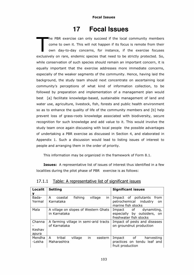
Focal Issues
103
17 Focal Issues
he PBR exercise can only succeed if the local community members
come to own it. This will not happen if its focus is remote from their
own day-to-day concerns, for instance, if the exercise focuses
exclusively on rare, endemic species that need to be strictly protected. So,
while conservation of such species should remain an important concern, it is
equally important that the exercise addresses more immediate concerns,
especially of the weaker segments of the community. Hence, having laid the
background, the study team should next concentrate on ascertaining local
community’s perceptions of what kind of information collection, to be
followed by preparation and implementation of a management plan would
best [a] facilitate knowledge-based, sustainable management of land and
water use, agriculture, livestock, fish, forests and public health environment
so as to enhance the quality of life of the community members and [b] help
prevent loss of grass-roots knowledge associated with biodiversity, secure
recognition for such knowledge and add value to it. This would involve the
study team once again discussing with local people the possible advantages
of undertaking a PBR exercise as discussed in Section 4, and elaborated in
Appendix 1. Such a discussion would lead to listing issues of interest to
people and arranging them in the order of priority.
This information may be organized in the framework of Form 8.1.
Issues: A representative list of issues of interest thus identified in a few
localities during the pilot phase of PBR exercise is as follows:
17.1.1 Table: A representative list of significant issues
Localit
y
Setting Significant issues
Bada-Yermal
A coastal fishing village in Karnataka
Impact of pollutants from petrochemical industry on marine fish stocks
Mala A village on slopes of Western Ghats in Karnataka
Impact of dynamiting, especially by outsiders, on freshwater fish stocks
Channa- Keshavapura
A farming village in semi-arid tracts of Karnataka
Impact of pests and diseases on groundnut production
Mendha-Lekha
A tribal village in eastern Maharashtra
Impact of harvesting practices on tendu leaf and fruit production
T

Focal Issues
104
Pardhi tanda
A village of semi-nomadic hunters-traders in eastern Maharashtra
Relative impacts of pesticide usage and hunting on quail and partridge populations
Teligram
A village dependent on paddy cultivation and aquaculture in Gangetic plains of West Bengal
Impact of pesticide usage on rearing of domestic ducks
17.2 Interested User groups:
It would be appropriate that these lists should represent significant
interests of diverse user groups, rather than the concerns of only the most
powerful segment of the population. Thus for the Channakeshvapura village
mentioned in Table 17.1.1, a short list of priority issues that the local
community members feel should be taken up in the initial phase of the full-
fledged PBR exercise is as follows:
17.2.1 Table : A short list of Channakeshvapura focal issues
User Group Issues
Owner-cultivator: orchards
Control of coconut mites Development of a live fence
Owner-cultivator: drylands
Control of various pests and diseases of groundnut Control of wild pigs
Herder: nomadic Control of various parasites and diseases of sheep Use of traditional herbal remedies to treat sheep diseases Management of grazing lands
Farm labour: orchards
Production of fish in irrigation tanks
17.2.2 Associated LSEs/ WSEs/ species/ species groups/ varieties/
functional species groups
The next step is to devise a list of the various [a] ecological habitats, or
Landscape/ waterscape element types, and [b] species, species groups,
varieties, functional species groups that are linked to each of these themes.
Table 17.2.2.1 provides an illustration of how such lists may be elaborated
with reference to some of the focal issues mentioned in Table 17.2.1. The list
of pertinent species/ species groups/ varieties should be reflected in those
selected for further investigation in terms of abundance, uses, ecological
knowledge, or management in Form 5.1. The list of pertinent functional
species groups should be reflected in those selected for further investigation
in terms of abundance, uses, or management in Form 6.1. Similarly, the list
of pertinent habitats should be reflected in those selected for further

Focal Issues
105
investigation as focal landscape/ waterscape elements in Form 10.1 and
10.3.
Table: Issues, habitats and species of interest
Issue Pertinent species/
species groups/
functional species
groups
Pertinent habitats
Control of leaf-miner (LF) pest of groundnut
Leaf-miner, alternative host plants for LF, microbial diseases and insect parasites of LF, bird predators of LF
Groundnut farms, farms where alternative hosts of LF such as soya beans are cultivated, farm bunds and scrub savannas harbouring wild plant hosts and bird predators of LF
Control of wild pigs
Wild food plants of wild pigs
Farms and orchards raided by wild pigs, scrub savannas, forests
Use of traditional herbal remedies to treat sheep diseases
Various plant species used as herbal remedies
Farms, grasslands, scrub savannas, forests, streams, lakes
Landscape types and Sub-types
106
18 Landscape Types and Sub-types
he next step in the PBR process is to document the current status
and trends over time in various physical and biological parameters,
ecosystem goods and services as well as management concerns with
respect to the LSE/WSE types and sub-types taken as a whole, e.g. all lakes
and ponds, or all patches of degraded semi-evergreen forest, or all rubber
plantations. This would be primarily based on group interviews. The
collection of the pertinent information may be organized within the
framework of Forms 9.1a, 9.2a, and 9.1b, 9.2b.
Forms 9.1a and 9.2a deal with the current status and on-going changes.
18.1.1 Form 9.1a: Documentation of status and dynamics of
various landscape element types/ sub-types considered as a
whole.
o Name of LSE type as a whole: Forest or grassland
o Local Name/s (if any): e.g. grasslands are locally known as bugyals
in Garhwal
o LSE sub-type: e.g. evergreen or semi-evergreen forest
o Local Name/s (if any):
o Topography: The predominant topographic type for the landscape
element type/ sub-type considered as a whole. For sake of
standardization, we suggest that selection be made from amongst
the following categories:
1. Plain, 2. Undulating, 3. Hilly, 4. Moderate slope, 5. Steep slope
o Total area (ha): The best estimate available for the type as a
whole, counting together the area of different patches of the type.
Thus, the total area of the forest may be 130 ha, fragmented into
3 patches of 65, 43 and 22 ha.
o Trend in change in area over past 10 years: For sake of
standardization, we suggest that selection be made from amongst
the following categories:
T

Landscape types and Sub-types
107
1.Substantial increase, 2. Moderate increase, 3. Little / No change,
4. Moderate decrease, 5.Substantial decrease
o Immediate reason & motivation: Thus, forests may be reduced
in area due to fires. There may be manifold complex reasons,
and these may be discussed at length.
o Long term reason & motivation: Fires may be being set to
improve grazing resources. There may be manifold complex
reasons, and these may be discussed at length.
Trend in change in vegetation strata (Big trees; Shrubs; Ground
cover) over past 10 years:
Trend in change in animal life over past 10 years:
These trends too will be recorded as: 1.Substantial increase, 2.
Moderate increase, 3. Little / No change, 4. Moderate decrease,
5.Substantial decrease
o Immediate reason & motivation: There may be manifold
immediate reasons and motivations for the trends, and these
may be described at length
o Long term reason & motivation: There may be manifold
immediate reasons and motivations for the trends, and these
may be described at length
o Significant activities: Significant activities pertaining to the LSE
type/ sub-type under consideration. These would be a sub-set
of activities noted in Forms 1.1 and 1.2.
o Goods & Services: The ecosystem goods and services obtained
from the pertinent LSE type/ sub-type. The concept of
ecosystem goods and services was discussed above in Section
12.2.1.1. There may be many, and these may be described at
length.
o User groups gaining most from goods & services: Important
beneficiaries of ecosystem goods and services obtained from
the pertinent LSE type/ sub-type. There may be many user

Landscape types and Sub-types
108
groups, gaining from different goods and services, and these
may be described at length.
o Local groups:
o External groups:
o Change in goods & services: Changes taking place in recent
past, especially last ten years.
o Immediate reason & motivation: There may be manifold
immediate reasons and motivations for on-going changes, and
these may be described at length.
o Long term reason & motivation: There may be manifold long
term reasons and motivations for on-going changes, and these
may be described at length.
o Bads & disservices: The ecosystem bads and disservices from
the pertinent LSE type/ sub-type. The concept of ecosystem
bads and disservices was discussed above in Section 12.2.1.1.
There may be many, and these may be described at length.
o User groups affected most by bads & disservices: Important
recipients of ecosystem bads and disservices obtained from the
pertinent LSE type/ sub-type. There may be many user groups,
suffering from different bads and disservices, and these may be
described at length.
o Local groups:
o External groups:
o Change in bads & disservices: Changes taking place in recent
past, especially last ten years.
o Immediate reason & motivation: There may be manifold
immediate reasons and motivations for on-going changes, and
these may be described at length.
o Long term reason & motivation: There may be manifold
immediate reasons and motivations for on-going changes, and
these may be described at length.

Landscape types and Sub-types
109
18.1.2 Form 9.2a: Documentation of status and dynamics of
various waterscape element types/ sub-types considered as a
whole.
o Name of WSE type as a whole: For instance, tanks and reservoirs
o Local Name/s (if any): For instance, tanks, reservoirs are known as
kere in Karnataka
o WSE sub-type: Streams, a subtype of streams and rivers
o Local Name/s (if any): Streams, a subtype of streams and rivers is
known as jhara in Maharashtra
o Total length of stream / river (km): Within the study area
o Trend in change in length over past 10 years: These trends will be
recorded as: 1.Substantial increase, 2. Moderate increase, 3. Little
/ No change, 4. Moderate decrease, 5.Substantial decrease
o Immediate reason & motivation: Certain streams may disappear
due to disruption of water flow due to road construction
o Long term reason & motivation: For example, migration of rural
population into urban centers
o Water spread area of the tank/pond/lake (ha): Within the study
area
o Trend in change in water spread area over past 10 years: These
trends too will be recorded as: 1.Substantial increase, 2. Moderate
increase, 3. Little / No change, 4. Moderate decrease, 5.Substantial
decrease
o Immediate reason & motivation: Certain lakes may disappear due
to house construction
o Long term reason & motivation: Rapid urbanization
o Availabilty of water (No. of days) for WSE: Within the study area
o Trend in change in availability of water over past 10 years: These
trends too will be recorded as: 1.Substantial increase, 2. Moderate

Landscape types and Sub-types
110
increase, 3. Little / No change, 4. Moderate decrease, 5.Substantial
decrease
o Immediate reason & motivation: May have increased due to
development of new canals in a command area
o Long term reason & motivation: Strong political support to
irrigation projects
o Change in flora & fauna over past 10 years: For instance, rapid
growth of water hyacinth
o Immediate reason & motivation: For instance, nutrient
enrichment of waters
o Long term reason & motivation: For instance, failure to
manage sewage treatment from urban centers
o Significant activities: Significant activities pertaining to the LSE
type/ sub-type under consideration. These would be a sub-set of
activities noted in Forms 1.1 and 1.2.
o Goods & Services: The ecosystem goods and services obtained
from the pertinent WSE type/ sub-type. The concept of ecosystem
goods and services was discussed above in Section 12.2.1.1. There
may be many, and these may be described at length.
o User groups gaining most from goods & services: Important
beneficiaries of ecosystem goods and services obtained from the
pertinent LSE type/ sub-type. There may be many user groups,
gaining from different goods and services, and these may be
described at length.
o Change in goods & services: Changes taking place in recent past,
especially last ten years.
o Immediate reason & motivation: There may be manifold immediate
reasons and motivations for on-going changes, and these may be
described at length.
o Long term reason & motivation: There may be manifold long term
reasons and motivations for on-going changes, and these may be
described at length.
Landscape types and Sub-types
111
o Bads & disservices: The ecosystem bads and disservices from the
pertinent LSE type/ sub-type. The concept of ecosystem bads and
disservices was discussed above in Section 12.2.1.1. There may be
many, and these may be described at length.
o User groups affected most by bads & disservices: Important
recipients of ecosystem bads and disservices obtained from the
pertinent LSE type/ sub-type. There may be many user groups,
suffering from different bads and disservices, and these may be
described at length.
o Local groups:
o External groups:
o Change in bads & disservices: Changes taking place in recent past,
especially last ten years.
o Immediate reason & motivation: There may be manifold immediate
reasons and motivations for on-going changes, and these may be
described at length.
o Long term reason & motivation: There may be manifold immediate
reasons and motivations for on-going changes, and these may be
described at length.
Forms 9.1b, 9.2b deal with management issues.
18.1.3 Form 9.1b: Documentation of different management issues
relating to various landscape element types/ sub-types
considered as a whole
o Name of LSE type as a whole: Forest or grassland
o Local Name/s (if any): e.g. grasslands are locally known as bugyals
in Garhwal
o LSE sub-type : e.g. evergreen or semi-evergreen forest
o Local Name/s (if any):

Landscape types and Sub-types
112
o Existing management authority: There may be a variety of formal
as well as informal management authorities pertaining to a given
LSE type such as forest. Thus one patch may be a reserved forest,
another a protected forest, a third patch may be on private land.
Local community members may have an understanding that a
certain patch is to be used by people from a particular hamlet, and
so on.
o Existing management system/ practices: There may be a variety of
formal as well as informal management authorities pertaining to a
given LSE type, such as grassland. For instance, some patches of
grasslands may be being converted into fuelwood plantations;
others encroached upon for cultivation, and so on. These should be
described in detail.
o Gainer User groups: Certain user groups, local or external, may
gain from the existing management system. For example, landless
agricultural labourers may gain from encroachment on grasslands.
These manifold interactions may be described in detail.
o Local groups:
o External groups:
o Loser user groups: Certain user groups, local or external, may lose
from the existing management system. For example, shepherds
may stand to lose from encroachment on grasslands. These
manifold interactions may be described in detail.
o Local groups:
o External groups:
o Other management patterns prevalent in recent past: Management
systems/ practices have been undergoing rapid changes in recent
times, and it would be useful to note these experiences, especially
from the perspective of devising more effective systems for the
future. These manifold experiences may be described in detail.
o User groups:

Landscape types and Sub-types
113
o Desired changes / desired future: This would entail documentation
of what the various user groups would like to see happen in the
coming days.
o Desired management system from the perspectives of different
user groups: This refers to the vision of different user groups of a
desirable management system. A number of different elements
would be involved in this vision. These may relate to (a) rights of
access to land, waters or biological resources, (b) roles of different
governmental agencies, private industry, landowners or community
institutions, (c) local versus outside actors, (d) technologies
employed, and (e) access to capital or markets, and so on. It
would be worthwhile to encourage the community members to give
full scope to their imagination and come up with a variety of
innovative solutions.
o Suggested components for a management plan that can be
implemented under present circumstances as a consensus of the
gram sabha: But finally, it is important to examine ground
realities, and the community members may be asked to shift from
what they would ideally like to see happen to suggesting elements
of a management plan that can be implemented under present
circumstances and for which a consensus of the gram sabha seems
feasible. Different user groups may come up with a range of such
plans; all of these may be recorded preserving their perspectives,
and taking care not to introduce any bias on part of those involved
in the documentation.
o Code numbers of focal elements selected for further study as
marked on the map: Apart from documenting the condition of LSE/
WSE types/ sub-types as a whole, largely based on group
discussions, it would be worthwhile to investigate some of the
specific habitat patches or landscape/ waterscape elements that
have been identified as of particular interest during the discussions
on focal issues (section 21). These may, for instance, include a
lake that serves as the principal source of drinking water, or the
most fertile patch of farmland (which may include several separate
individual holdings next to each other). In addition, it may be
useful to select some representative examples of the various LSE/

Landscape types and Sub-types
114
WSE types/ sub-types as focal elements for further investigations.
These may be the largest and one of the average sized patches of
each type/ sub-type. However, the actual number of such focal
elements selected will depend upon the practical constraints such
as time of teachers and students available for these activities.
18.1.4 Form 9.2 b: Documentation of different management
issues relating to various waterscape element types/ sub-
types considered as a whole
o Name of WSE type as a whole: For instance, tanks and reservoirs
o Local Name/s (if any): For instance, tanks, reservoirs are known as
kere in Karnataka
o WSE sub-type: Streams, a subtype of streams and rivers
o Local Name/s (if any): Streams, a subtype of streams and rivers is
known as jhara in Maharashtra
o Existing management authority: There may be a variety of formal
as well as informal management authorities pertaining to a given
WSE sub-type such as tanks. Thus one tank may be under the
control of minor irrigation department, another may be on private
land. Local community members may have an understanding that
a certain tank is to be used by people from a particular hamlet,
and so on.
o Existing management system/ practices: There may be a variety of
formal as well as informal management authorities pertaining to a
given WSE sub-type, such as tanks. For instance, some tanks may
be being drained to create housing sites; others may be well
managed as recreational areas, and so on. These should be
described in detail.
o Gainer User groups: Certain user groups, local or external, may
gain from the existing management system. For example, builders
may gain from encroachment on tanks. These manifold interactions
may be described in detail.

Landscape types and Sub-types
115
o Local groups:
o External groups:
o Loser user groups: Certain user groups, local or external, may
stand to lose from the existing management system. For example,
farmers may stand to lose from encroachment on tanks. These
manifold interactions may be described in detail.
o Local groups:
o External groups:
o Other management patterns prevalent in recent past: Management
systems/ practices have been undergoing rapid changes in recent
times, and it would be useful to note these experiences, especially
from the perspective of devising more effective systems for the
future. These manifold experiences may be described in detail.
o User groups:
o Desired changes / desired future: This would entail documentation
of what the various user groups would like to see happen in the
coming days.
o Desired management system from the perspectives of different
user groups: This refers to the vision of different user groups of a
desirable management system. A number of different elements
would be involved in this vision. These may relate to (a) rights of
access to land, waters or biological resources, (b) roles of different
governmental agencies, private industry, landowners or community
institutions, (c) local versus outside actors, (d) technologies
employed, and (e) access to capital or markets, and so on. It
would be worthwhile to encourage the community members to give
full scope to their imagination and come up with a variety of
innovative solutions.
o Suggested components for a management plan that can be
implemented under present circumstances as a consensus of the
gram sabha: But finally, it is important to examine ground
realities, and the community members may be asked to shift from
what they would ideally like to see happen to suggesting elements

Landscape types and Sub-types
116
of a management plan that can be implemented under present
circumstances and for which a consensus of the gram sabha seems
feasible. Different user groups may come up with a range of such
plans; all of these may be recorded preserving their perspectives,
and taking care not to introduce any bias on part of those involved
in the documentation.
o Code numbers of focal elements selected for further study as
marked on the map: Apart from documenting the condition of LSE/
WSE types/ sub-types as a whole, largely based on group
discussions, it would be worthwhile to investigate some of the
specific habitat patches or waterscape elements that have been
identified as of particular interest during the discussions on focal
issues (section 17). These may, for instance, include a lake that
serves as the principal source of drinking water. In addition, it may
be useful to select some representative examples of the various
WSE types/ sub-types as focal elements for further investigations.
These may be the largest and one of the average sized patches of
each type/ sub-type. However, the actual number of such focal
elements selected will depend upon the practical constraints such
as time of teachers and students available for these activities.

Focal Element of Landscape/Waterscape
117
19 Focal Elements of Landscape/ Waterscape
19.1 Field observations
hese focal elements, marked on the map, and recorded in Forms 9.1b
and 9.2b, may be investigated further both through field visits,
preferably in company of some knowledgeable members of the
community, as well as through group discussions. The field observations may
involve aspects such as identity of neighbouring LSEs or modifications such
as construction of check dams on streams. They would also involve recording
of observations such as vegetation cover (for landscape elements), or nature
of bottom substrate (for waterscape elements) at specific sampling points.
Forms 10.1 and 10.3 indicate the schedules for recording the overall
observations, while Forms 10.2 and 10.4 indicate the schedules for recording
observations at specific sampling points. These field visits may also be used
to record observations on the abundance of focal species/ functional groups
in these focal elements of landscape/ waterscape. The details of how to
select the sampling points were discussed above in section 12.2.2.2 and
12.2.2.4. The information to be recorded in Forms 10.1 and 10.3 follows the
pattern of Forms 9.1a and 9.2a discussed in Section 22 above. The only
difference is that these observations noted in 10.1 and 10.3 pertain to a
specific patch of forest or a specific pond, rather than all forests and ponds in
the study site. In view of this focus on a specific element, the form calls for
certain information such as: surrounding LSE/ WSE types, distance from a
motorable road, duration (hours or days units should be mentioned) of
inundation due to flood water during last one year, and so on.
19.1.1 Form 10.1 Focal landscape elements field survey
o Name of LSE type as a whole:
o LSE sub-type :
o LSE code:
o Local name of the landscape element (if any):
o Topography:
T

Focal Element of Landscape/Waterscape
118
o Area (Ha)
o Surrounding LSE/WSE types:
o Distance from Habitation (Km)
o Distance from motorable Road (Km)
o Current management
o Activities:
o Significant harvests/ removals, e.g. fuel wood:
o Significant additions: e.g. pesticides
o Significant modifications: e.g. leveling by bull-dozer
o Goods & services:
o Bads & disservices:
19.1.2 Form 10.3 Focal waterscape elements field survey
o WSE type :
o WSE sub-type :
o WSE code- unique serial number in the study area
o Local name of WSE (if any)
o Area (Ha)
o Maximum depth of water within the study area during last one year
(m)
o Estimated Length [for streams/ rivers] within study area (m)
o Average Breadth [for streams/ rivers] within study area (m)
o Water spread area [ for tanks and lakes (Ha)]
o Duration (hours or days units should be mentioned) of inundation
due to flood water during last one year
o No. of days / months (specify unit) water present

Focal Element of Landscape/Waterscape
119
o Surrounding LSE/WSE types
o Distance from Habitation (Km)
o Distance from motorable Road (Km)
o Current management
o Activities:
o Significant harvests/ removals: e.g. fish
o Significant additions: e.g. city sewage
o Significant modifications: e.g. dams
o Goods & services:
o Bads & disservices:
Forms 10.2 and 10.4 provide the framework for recording observations
at specific sampling points for the selected landscape or waterscape element.
The details of how to select the sampling points were discussed above in
section 12.2.2.2 and 12.2.2.4.
19.1.3 Form 10.2 Focal landscape elements vegetation cover
o Name of LSE type:
o LSE sub-type :
o Local name of LSE (if any)
o LSE code- unique serial number in the study area
o Sampling point number:
o Vegetation cover: To be selected from amongst the following options:
1.Under a tree canopy, 2. Covered by a shrub, 3.With Herbaceous
vegetation, 4. On Barren land, 5. Paved land, 6. Inside a building. Multiple
options may be selected for any given sampling point.
19.1.4 Form 10.4 Focal waterscape elements sampling studies
o Name of WSE type:
o WSE sub-type:
o Local name (if any)
o WSE code- unique serial number in the study area

Focal Element of Landscape/Waterscape
120
o Local name (if any)
o Sampling point number
o Observation about WSE
o Nature of sampling site (water body) under survey:
In case of streams or rivers, this is to be selected from:
1 Run: Smooth, rapidly flowing section of a stream or river
2 Riffle: Shallow stream with rough substrate leading to ripples on
surface
3 Cascade: Rapidly descending stream or river
4 Pool: An area of deeper, more quiet water in the course of a stream or
river
5 Waterfall:
o Nature and extent of pollution
o Bottom substrate:
1.Bed rock
2. Boulders
3. Cobble
4. Sand
5. Mud
19.2 Interviews
Appropriately designed interviews would provide information on status,
dynamics, and management issues relating to various focal landscape/
waterscape elements selected for further documentation. Forms 11.1a, 11.2a
refer to the recent history of the focal elements. The information to be
recorded in Forms 11.1a and 11.2a follows the pattern of Forms 9.1a and
9.2a discussed in Section 22 above. The only difference is that these
observations noted in 11.1a and 11.2a pertain to a specific patch of forest or
a specific pond, rather than all forests and ponds in the study site.

Focal Element of Landscape/Waterscape
121
19.2.1 Form 11.1a Focal landscape elements history
o Name of LSE type:
o LSE sub-type :
o LSE code
o Local Name of the focal LSE
o Trend in area over the past ten years and reasons
o Trend in change in area
o Immediate reason & motivation
o Long term reason & motivation
o Trend in change in vegetation strata over the past ten years and
reasons:
o Big trees
o Shrubs
o Ground cover
* Trend in change in animal life over the past ten years and reasons:
o Immediate reason & motivation
o Long term reason & motivation
o User groups (local & external) gaining most from goods and
services:
o Local groups
o External groups
o Goods and services
o Change in goods & services and reasons.
o Changes
o Immediate reason & motivation

Focal Element of Landscape/Waterscape
122
o Long term reason & motivation
o User groups (local & external) losing most from bads and
disservices:
o Local groups
o External groups
o Bads and disservices
o Change in Bads & Disservices and reasons
o Changes
o Immediate reason & motivation
o Long term reason & motivation
19.2.2 Form 11.2a Focal waterscape elements history
o WSE type
o WSE sub-type
o WSE code
o Local Name of the focal WSE
o Trend in area over the past ten years and reasons
o Trend in change in area
o Immediate reason & motivation
o Long term reason & motivation
o Trend in change availability of water over past ten years and
reasons:
o Trend
o Immediate reason & motivation
o Long term reason & motivation
Focal Element of Landscape/Waterscape
123
o Trend in change in abundance of major plant and animal species
over past ten years and reasons:
o Trend
o Immediate reason & motivation
o Long term reason & motivation
o User groups ( local & external) gaining most from goods and
services
o Gainer UG Local
o Gainer UG External
o Goods and services
o Change in goods & services and reasons.
o Changes
o Immediate reason & motivation
o Long term reason & motivation
o User groups (local & external) losing most from bads and
disservices:
o Local groups
o External groups
o Bads and disservices
o Change in Bads & Disservices and reasons
o Changes
o Immediate reason & motivation
o Long term reason & motivation
Forms 11.1b and 11.2b refer to management issues pertaining to the
focal landscape and waterscape elements under investigation. The

Focal Element of Landscape/Waterscape
124
information to be recorded in Forms 11.1b and 11.2b follows the pattern of
Forms 9.1b and 9.2b discussed in Section 22 above. The only difference is
that these observations noted in 10.1 and 10.3 pertain to a specific patch of
forest or a specific pond, rather than all forests and ponds in the study site.
19.2.3 Form 11.1b Focal landscape elements management
o Name of LSE type:
o LSE sub-type :
o LSE code
o Local Name of the focal LSE
o Existing managing authority
o Existing management system/ practices
o Gainer Local user group :
o Gainer External user group:
o Loser Local user group :
o Loser External user group:
o Other management patterns prevalent in recent past
o User group
o Desired changes/ desired future
o Desired management system
o Suggested components for a management plan that can be
implemented under present circumstances as a consensus of the
gram sabha
19.2.4 Form 11.2b Focal waterscape elements management
o Name of WSE type:
o WSE sub-type:

Focal Element of Landscape/Waterscape
125
o WSE code
o Local Name of the focal WSE
o Existing managing authority
o Existing management system/ practices
o Gainer user group Local:
o Gainer user group External:
o Loser user group Local:
o Loser user group External:
o Other management patterns prevalent in recent past
o User group
o Desired changes/ desired future
o Desired management system
o Suggested components for a management plan that can be
implemented under present circumstances as a consensus of the
gram sabha
Focal Life Forms
126
20 Focal Life Forms
uring the earlier exercise of preparing an inventory of locally known
life forms (section 19), a set of species/ functional species groups
would have been identified as the focus of further investigations
relating to [a] abundance, [b] value/uses, [c] management and [d] practical
ecological knowledge. This module would deal with collecting the required
information on basis of field observations as well as interviews.
20.1 Field observations
As mentioned above in sections 12.2.2.1 and 19.1, field surveys of focal
landscape/ waterscape elements may usefully include observations on the
abundance of focal species, or functional species groups. Form 12.1 provides
details of the information to be collected. This recording of abundance will
necessarily be qualitative and subjective.
20.1.1 Form 12.1: Focal taxa abundance field survey
o Name of LSE type:
o LSE sub-type :
o LSE/WSE code:
o Local Name of the Focal LSE / WSE:
o Local name of the focal species/variety/species group /functional
species group: This would conform to the name recorded in Form
5.1.
o Level of abundance: This will have to be based on subjective
judgment of the abundance in the particular habitat under
observation compared to normally expected abundance of the
species etc under consideration. Thus, to be judged as moderately
common, a weed like Parthenium or a bird like the house crow
would occur in far greater numbers than a herb like Tridax
D

Focal Life Forms
127
procumbens or a bird like Indian Roller. Abundance will be scored
in terms of following categories:
1 - Absent
2 - Rare
3 - Moderately common
4 - Abundant
20.2 Interviews
Appropriately designed interviews would provide information on status,
dynamics, and management issues relating to various focal taxa and species
groups selected for further documentation. Forms 13.1, 13.4a, and 13.4b
indicate details of the points on which information may be recorded.
20.2.1 Form 13.1: Focal taxa status & trends in abundance
o Local name of focal species/ species group/ / functional species
group: From Form 5.1.
o LSE/WSE types/ sub-types favored by the species / species group:
Habitats in which the concerned entities are relatively more
abundant.
o Current level of abundance: To be selected from:
1 - Absent
2 - Rare
3 - Moderately common
4 - Abundant
o Trend and reasons behind trend
� Trend in abundance in last 10 years: To be selected from:

Focal Life Forms
128
1. Substantial increase
2. Moderate increase
3. Little / No change
4. Moderate decrease
5. Substantial decrease
� Immediate reason & motivation: Thus, the abundance of
weedy Eupatorium may have increased due to fires. There
may be other manifold complex reasons also, and these
may be discussed at length.
� Long-term reason & motivation: Fires may be being set to
improve grazing resources, or to facilitate collection of
Mahua seeds etc. There may be manifold complex reasons,
and these may be discussed at length.
20.2.2 Form 13.4a: Focal taxa: management
The information in this Form would follow the same pattern as suggested
for Forms 9.1b and Form 9.2b in Sections 18.1.3 and 18.1.4 above.
o Local name of species/ species group/ functional species group
o Changes in goods and services and reasons
o Change in goods & services
� Immediate Reason
� Long term reason
o Existing managing authority
� Existing management system/ practices
� Gainer user group Local:
� Gainer user group External:
� Loser user group Local:

Focal Life Forms
129
� Loser user group External:
� Other management patterns prevalent in recent past
20.2.3 Form 13.4b: Desired changes, management system from
the perspectives of different user groups and suggested
components for management regarding focal species
(management).
The information in this Form would follow the same pattern as suggested
for Forms 9.1b and Form 9.2b in Sections 18.1.3 and 18.1.4 above.
o Local name of species/ species group/ functional species group/ variety
o User group code
o Desired changes/ desired future
o Desired management system from the perspectives of different user
groups
o Suggested components for a management plan that can be implemented
under present circumstances as a consensus of the gram sabha

Knowledge
130
21 Knowledge
21.1 Public versus confidential
n parallel with this documentation of habitats and species may go on a
process of documentation of people’s knowledge regarding these
entities. Consider the issue of control of leaf miner, a moth whose
caterpillar is a major pest of groundnut as well as soyabean and some other
crops. Farmers have a number of thumb rules as to the climatic conditions
under which leaf miner populations either thrive or are suppressed. There is
little good scientific data on this matter, and there may be much to be
gained by combining farmers’ knowledge with scientific knowledge. In this
case the farmers may be very happy to make their knowledge publicly
available and may not wish to insist on any intellectual property rights (IPR)
and maintenance of confidentiality.
Consider, as a second case, use of traditional herbal remedies to treat
sheep diseases. Such knowledge may be being lost rapidly as younger
people become increasingly alienated from nature and it may be very
worthwhile to record it. However, there may be definite possibilities of
commercial exploitation of such knowledge and the knowledge holder/s may
wish to assert their IPRs and make the knowledge available only to specific
parties under specified conditions (diagram 11). As explained above in
Section 5.5, documentation of such knowledge may be taken up after a
proper system for the management of confidential information has been put
into place (see diagram 2).
I

Knowledge
131
.
Knowledge
Shared without any
reservation
Shared conditionally, on
basis of certain
stipulations
Uses of
biodiversityManagement of habitats,
biodiversity
May be relevant to
May be desired to be
Diagram 11: Schematic representation of
entities of “knowledge” class and their relationships.
21.2 Uses
At this stage, we will record a limited range of information on uses
of the focal set of species, ensuring that people have no hesitation in making
it public. Form 13.3 indicates details of the points on which information may
be recorded.
21.2.1 Form 13.3: Focal taxa status & trends in value/ uses
o Local name of species/ species group/ functional species group:
From Form 5.1.
o Part used: For example, root or feather
o Useful products: e.g. charcoal, mango pickles
o Uses, including symptoms treated in case of medicinal uses
o Change in uses over the last ten years: To be selected from:
1) Substantial increase

Knowledge
132
2) Moderate increase.
3) Little \ No change
4) Moderate decrease
5) Substantially decrease
o Pin code of the destination of the harvests: Pin-code of the
nearest, significant market town or city to which a significant
proportion of the harvests is exported.
21.3 Ecological knowledge
In addition, an attempt should be made to document the extent of the
ecological knowledge of the people in a free-hand fashion on the basis of the
checklist provided in Form 14.1. For this purpose, a small number, 5 to 10 of
species most significant from people’s perspective, perhaps representing the
most important fish and shellfish, bird, wildlife and medicinal and food plant
species may be chosen as the focal species.
21.3.1 Form 14.1: Folk knowledge of population ecology, life
history and behavior
o Local name of the focal species/ species group/ functional species
group (knowledge): From Form 5.1
o Abiotic conditions favouring the focal species/ species group
o Type of ecosystems favouring the focal species/ species group
o Food organisms of the focal species/ species group
o Foraging and feeding behavior
o Competitors of the focal species/ species group
o Competitive behavior
o Predators on the focal species/ species group
o Predator avoidance behaviour

Knowledge
133
o Parasites/ diseases of the focal species/ species group
o Parasite avoidance behaviour
o Organisms favouring focal species/ species group, e.g. pollinators,
seed dispersers
o Life history stages
o Parental care
o Breeding behaviour
o Social habits
o Territorial behaviour
o Communication behaviour, displays, calls, scent markings
o Seasonal changes in the abundance of members of the focal
species/ species group
o Consequences of ecological processes like fire or grazing
o Human influences on focal species/ species group

Management
134
22 Management
n important outcome of the PBR exercises would be the preparation
of a Management Plan to support the activities of the local
Biodiversity Management Committee (BMC). The management plan
would concentrate on the issues identified as constituting the focal issues
(section 17). A set of interested user groups, landscape and waterscape
element types and sub-types, species as well as functional species groups
would have been identified as being pertinent to these focal issues. These
would have been studied in further detail; leading to the documentation of
the system of management desired, as also considered feasible given the
prevalent constraints by various interested user groups (Section 12.2.3). All
of this would provide a substantial background to be shared with all residents
of the locality, as also concerned outsiders. A management plan may then be
drafted with a focus on the various key issues, debated and finally adopted in
the gramsabha, or equivalent assembly of all the residents.
The plan may provide inputs on specific follow up actions relevant to the
implementation of the Biological Diversity Act. Thus, it may include
suggestions, with special reference to the area under the jurisdiction of the
BMC, on: [a] constitution of heritage sites, for instance, in Mala people would
like the area around a scenic waterfall conserved as a heritage site; [b]
declaration of threatened species, for instance, in Mala, and perhaps all over
Karnataka Western Ghats, it might be appropriate to declare a Myristica
swamp species, Myristica fatua as a threatened species; [c] ban on harvest
of some species, for instance, in Mala it might be prudent to temporarily ban
all harvests of highly depleted fish species belonging to genus Channa; [d]
regulation of harvests of other species, for instance, in Mala, it might be
prudent to strictly regulate harvests from the highly overexploited Garcinia
cambogea; [d] levying of collection charges from outsiders harvesting certain
species, for instance, in Mendha-Lekha the Panchayat could raise substantial
funds by levying charges on collection of Tendu and Mahua; [e] regulation of
outsiders engaging in recording of knowledge associated with biodiversity
along with levying of some collection charges, [f] Local level value addition
activities, eg., processing of Garcinia combogea fruit, [g] Effective marketing
strategies, eg., tying up with a group markting produce of organic agriculture
in metropolitan centers.
A

Management
135
A variety of activities relating to decentralized planning for management
of natural resources are already under way in different parts of the country.
These include Watershed Development Plans as also Joint Forest Planning
and Management. These activities are obviously complementary to PBR
Management Plan preparation and should be properly coordinated. The main
difference amongst them is that the Watershed Development and Joint
Forest Management Plans pertain to one particular sector and are expected
to be very detailed. The PBR Management Plans will have a broader scope
and would provide a framework for more detailed plans. Such detailed plans
may pertain to themes like: [a] Local breeding and release of biological
control agents for control of the leaf miner pest of groundnut, [b]
Implementation of total ban on dynamiting and poisoning of streams in
course of fishing in streams and ponds, [c] Long term conservation of sacred
groves, [d] Elimination of stagnant water pools providing habitats for
mosquito breeding around habitations, and so on.
We quote here two interesting examples of how such broad plans may
be elaborated.
♦♦♦♦♦♦♦♦♦♦♦♦♦♦♦♦♦♦♦♦♦♦♦♦♦♦♦♦♦♦♦♦♦♦♦♦♦♦♦♦♦♦♦♦♦♦♦♦♦♦♦♦
22.1 Box: A management plan for medicinal plant resources
of Nagavalli
The first example is provided by a school level study conducted in
support of the preparation of the Karnataka Biodiversity Strategy and Action
Plan. As a part of this effort, a team of teachers and students, led by Shri
B.V. Gundappa, a Biology teacher in the local Pre-University College, made
an assessment of the medicinal plant resources of Nagavalli Village
Panchayat (Tumkur taluk, Tumkur district, Karnataka) on the basis of
individual and group interviews. During these discussions the local people
came up with the following proposals:

Management
136
A. Community members are afraid that the culture and tradition
of which the use of medicinal plants is an integral component may
come to an end with their generation. To forestall this, they suggest
that a series of steps be taken urgently:
� Create awareness regarding medicinal plants among people.
� Prepare a checklist of locally accessible medicinal plants.
� List the endangered and threatened plants amongst these.
� Enumerate the uses of different plants and how to use the plants
as a medicine
� Place name boards over the trees/ plants with uses.
� Prepare information material on plants that can be grown in the
kitchen gardens.
� Arrange workshops on identification, uses, and conservation of
medicinal plants for the local people.
� Develop projects for storage and preservation of the seeds and
other parts of the plant at one center.
� Encourage work on cultivation and hybridization of these medicinal
plants.
� Develop gene banks to protect endangered plants on the brink of
extinction.
� Prepare an action plan regarding cultivation of endangered and
threatened medicinal plants in restricted, protected lands.
� Create a park exclusively of medicinal plants close to the village
and educate people who visit that park.
� Form a local body, to act like a watchdog, to prevent smuggling,
excess cutting or collection of medicinal plants.
B. Measures for Protection of Habitat of Medicinal Plants:
� Not to disturb the existing landscape.

Management
137
� Protect the medicinal plants occurring now in the agricultural lands.
� Reduce the use of chemical fertilizers and manure.
� Encourage biological control measures.
C. They suggested specific roles for the following agencies:
� Villagers: Try to acquire some knowledge of the medicinal plants
available in their locality, and try to protect them, prevent
smuggling, cutting, and destroying the medicinal plants.
� Forest Department: Prevent smuggling, theft of some of the trees
like sandal, teak, neem etc. Establish nurseries, distribute
seedlings and plants at a low cost and encourage farmers to grow
economically valuable trees like sandal, teak, mango, silver oak by
giving protection to them.
� Joint Village Forestry Committee: A committee involving both
forest department, and village members should be formed, and it
should identify empty lands near by village where nothing has
been grown, and in those lands try to cultivate medicinal plants.
� Agricultural department: Establish research centers, nurseries, and
medicinal plant gardens where information regarding cultivation of
medicinal plants will be available, and medicinal plants will be
supplied at nominal cost to the people. Establish a center where
people can sell their products for a reasonable price.
� NGOs: Education and awareness creation regarding medicinal
plants through posters, street plays, skills etc.
� Agencies preparing Ayurvedic medicines: Visit the locality on fixed
days and purchase the medicinal plants. Encourage people who
grow medicinal plants on an extensive scale by giving some
incentives, such as loan, and subsidy.
� Gram Panchayat: Pass a resolution that people should take
permission and clearance from Gram Panchayat when collecting
medicinal plants and also when cutting trees like neem, mahua,
Pongomia etc.

Management
138
� Taluk Panchayat: Monitor the activities of Gram Panchayat and
also help out interested people in maintaining and conserving
medicinal plants.
� District Panchayat: Organize workshops for NGO’s, Govt. officials,
officers, teachers regarding the traditional uses and importance of
medicinal plants and encourage them to continue those elements
of the culture and tradition that are practical.
� A medicinal plants conservation agency should be formed, with
sub-units in schools etc. This agency should monitor village level
action plans prepared by the villagers.
♦♦♦♦♦♦♦♦♦♦♦♦♦♦♦♦♦♦♦♦♦♦♦♦♦♦♦♦♦♦♦♦♦♦♦♦♦♦♦♦♦♦♦♦♦♦♦♦♦♦♦♦
22.2 Environmental problems of Chilika Lake and their
solutions.
Another excellent example of a management plan, spontaneously arrived
at by local citizens pertains to the Chilika Lake in Orissa. The Headmaster,
Middle School, Kalupada Ghat submitted this plan to Dr. A.K.Pattnaik, CEO,
Chilika Development Authority on 31st December 2005 on behalf of the local
community. This is quoted below, without any editing.
Problem 1: The Chilika Lake is gradually silting
Solution: The Chilika Lake is gradually silted with sedimentation
and aquatic weeds and moss. Hence the area and the water storage
capacity is in down trend. Therefore living style condition of fishermen
community and non fishermen community living in Chilika area put into
trouble. The reasons for siltation are sedimentation by rivers flowing into
Chilika, rioting of weeds and growth of varieties weeds in neighborhood.
Moreover we are throwing garbage daily to the lake which help for siltation.
The methods of solution of above problems are:
� Management of sedimentation � Protection of weeds � Prohibition of throwing of garbage � Conservation of soil through mass plantation on adjoining and catchment
area � Better management of the lake involving local people � Opening of new mouths where necessary � Protection of flow of agriculture land � Construction of ring embankment etc. is essentially required.

Management
139
Problem 2: Birds Problem in Chilika
Solution: Birds increase the scenery of the Chilika lake. Tourists
coming to Chilika for enjoying birds but gradually birds population in
Chilika is decreasing. The reasons behind it are degradation of forests from
adjoining land, dearth of food, action of hunters, use of chemical fertilizers
and pesticides on agriculture land, plying of motor boat, lack of awareness
among people for conservation of birds, inactiveness of Government to
pronounce suitable policy for birds security.
Hence registration of forests with green vegetative coverage in south-
east area and the Security of natural forests of Nalabana is urgently
required. Because, large number of birds are reside here by constructing
their nest.
In case of necessity identification of security place of Birds in other sites
and their development should be made. Use of zero net and siltation of
Chilika mouth is another reason for food deficit. Of the lake water will be
Chilika and will develop food production for birds and prohibition of zero
net will solve the problem of food deficit of birds.
Application of chemical fertilizers and pesticides in adjoining agriculture
land make pollution to the Chilika water and make harmful to the birds and
few of them put into death. Few birds lost their breeding capacity. Hence
use of the Chemical fertilizers on land may be prohibited, if it is not possible,
arrangement may be made to draining of the alkaline and polluted water of
adjoining land direct to sea.
By plying of motorboat bird population also decreased. Due to engine
sound of motorboat, collection food and breeding of birds hampering. The
oil leakage from the engine oil on the lake water and stick to the wings of
birds and they cannot fly. At long run the birds are die. Hence playing of
motorboats in Chilika shall be prohibited or alternative measures taken to
reduce the engine sound and leakage of oil. Alternative method may also be
find out for providing income source for the bird hunters for their sustenance.
Birds population also decreased due to bird hunting. To protect bird
hunting required legal provisions may also be made and for awareness
generation among people workshops may also be organized.
Problem 3: Fishery resources

Management
140
Solution: Fish production has been influenced to the economic
condition of the local people of Chilika area. As such without destruction of
fish production how fish production will be increased; it is the responsibility
of the local people. Catching of Juveniles should be completely prohibited to
keep the mouths free. If the use of zero net be destroyed, traditional
method shall be adopted during fishing operation, throwing of garbage to
Chilika allowing the fellow of alkaline polluted water catching of prawn
juvenile will be prohibited, then the fish production in Chilika will be
improved.
Problem 4: Plying of Motor boat
Solution. Playing of motor boats in Chilika cause water pollution
through leakage of oil contents like petrol, diesel etc., for which fish eggs
are destroyed. Fish production has been hampered. This also put a strain on
economic condition of the local people. So playing of motor should be
prohibited.
Problem 5: Prawn Culture Problem
Solution:The area of the lake is gradually reduced due to prawn
culture embankments (gheri).This protects the growth of fish. Also the
prawn culture increases the social disturbances by outsider non-fishermen.
Hence the prawn culture fields shall be completely evicted and the
disturbances in this area may be protected.
Problem 6: Excessive use of Chemical fertilizers and pesticides
Solution: The Chemical fertilizer and pesticides are harmful to the
culture. On the context of large scale use of chemical fertilizers and
pesticides by the cultivators on their adjoining cultivated land alkaline water
flowing to Chilika and make water pollution and cause harmful to fish and
juveniles and many fish suffered by disease. By taking these diseased fish
as food, human kind is also suffered by various diseases. Also by drinking
of the polluted water and eating the disease fish birds are into death. Fish
production in Chilika has been reduced and effecting the economic
condition of local people. Hence without using chemical fertilizers and
pesticides, if organic manure and scientific method shall be applied for
protection of disease on agriculture fields.
Problem 7: Decrease of salinity in lake water

Management
141
Solution: The salinity Quality of lake water help for development
fish production in Chilika. The fishery resource of Chilika is the main
resource for economic benefit for the Chilika area. The decrease in fish
production hamper the economic growth of local people of Chilika area.
The decrease in fish production hamper the economic growth of local
people. To solve this problem steps may be taken to increase the salinity
quality of lake water.
The main reason for decrease the salinity of water are soil erosion
from adjoining land, stone crushing, destruction of forests, drainage of
waste, for which the lake has been silted and the salinity of water reduced.
In past period, many channels were connected to the sea from the lake.
These channels were closed by siltation.
To solve the problem digging of Chilika is necessary steps may be taken
to prohibit the entry of garbage, digging of all the channels including Palur
to influx of safe water, in order to maintain the salinity of the water.
Problem 8: Problem of over flooded and drainage of excess water and
entry of saline water on adjoining agriculture land
Solution: India is basically an agrarian country; moreover the people
of Orissa are dependent on paddy cultivation. It is Primary occupation of the
people. If paddy cultivation is disturbed for any reason, then the economical
development of the people is not possible. The over flooded of Chilika and
drainage of water, increase of salinity on agriculture land created major
problem for the economic situation of local people. Hence the solution of
these problems are necessary.
In rainy season Chilika lagoon has been over flooded and make
waterlogged to the adjoining agriculture land and hence better crop could
not been harvested. Besides the submersion of saline water continue for
long period without driving away and deteriorate the soil quality to the
agricultural lands. On the other hand the mouths of rivers and rivulets are
silted. The flood water creating waterlogged for long period and the crops
destroyed. To remove this difficulties digging of mouths, river mouths and
canals from Kanas Block office up to Alibada Kharakhara via Balipada,
Kholada etc. Canal may be constructed from Gobardhanpur barrage up to
Lunanadi from barrage to Talamala for irrigation purpose and in other

Management
142
places of Kanas Block. If these projects will be implemented, the problem of
water logging will be removed and better crop can be harvested.
Problem 9: Communication Problem
Solution: Better communication facilities are the sign of a developed
area. In absence of better communication facilities, the inhabitants of the
area lagging behind socially, economically and in health status and enjoying
a better communication facilities are required in Chilika area.
For non-availability of better communication the people of rural villages
of Chilika island facing many problems. Hence communication facilities from
village may be developed. Construction of a pucca road from Bhusandpur to
Sunamuhin in Chilika belt may be made. Repair of road where necessary
may be done.
Problem 10: Problem of growth of aquatic weeds
Solution: To meet the requirement of food stuff of increased population
of the country, cultivation of hybrid paddy is essentially necessary. For
cultivation of hybrid paddy, farmers use chemical fertilizers and pesticides
on adjoining land flow into Chilika water and helping-the growth of weeds
and moss in the lake. The rots of the weeds and moss silting the lake. Hence
steps may be take to control the growth of weeds and moss awareness
generation among the people as well as an alternative action plan.
Problem 11 : Degradation of forests and reduce of trees
Solution: Tree is the life. Plantation of tree around Chilika lake will
increase the natural scenery and help in timely rain, soil conservation and
living places for birds. Conservation of tree, forests and plantation of tree
around Chilika lake is essentially required. The Casuarina forests of costal
belt has been destroyed by the domestic animals and local people and saline
water submerged to the agriculture land and destroying crops. So
casuarinas forests, and Government may also taken steps for conservation
of it.
Problem 12: Education and health Problem
Solution: Education and health are fundamental right of humankind.
Therefore emphasis should be given on these on these two issues of the
people of Chilika area. There are many villages in Chilika Island which has

Management
143
no communication facility and people of these villages depend on boat
service. Moreover within 22 km radius from Khajuria there is no health
centre or dispensary. Hence for establishment of a upgraded hospital
at Khajuria with improved equipment, staff, with high potentiality given
priority.
The water resources are contain saline contents and became polluted.
Steps may be taken to provide potable drinking water to every village. For
every family sanitary latrine may be constructed. If the above programmes
are implemented the health status of local people will be improved.
There is no infrastructure for vocational education and the
unemployment problem increased. Arrangement for establishment also
reduce the pressure over Chilika by the local people to some extent.
Problem 13: Prawn culture rings
Solution: The area of the lake is gradually reduced due to prawn
culture embankments (gheri).
This affects the growth of fish. Also the prawn culture increase the social
disturbances by outsider non fishermen. Hence the prawn culture fields shall
be completely evicted and the disturbances in this area may be protected.
Problem 14: Use of zero-net (the mesh size of the net is very small) and
catch of juveniles
Solution: For catching of juveniles and use of zero-net the fish
production in Chilika has been reduced and it is apprehended that the
fishermen community will suffer. Due to decrease in fish production and
catch fish quality, the dry fish business of women folk also reduced and
economic condition of the fishermen community is badly affected. Therefore
they could not give marriage to their daughters which creating instability in
society.
Hence use of zero-net, catch of juveniles should be prohibited and steps
taken to make planning's for their development of fish production
otherwise the fishermen community will be turn into a neglected society.
This will stand as a major problem for the country.

Management
144
Problem 15: Role of outsider non-fishermen unsocial elements
Solution: Leasing out of the fishery resource on lease and sublease
basis to the influenced persons and the outsiders should be discontinued. All
the fishery sources shall be settled with the local fishermen. By this change
the lake will be from social problems.
Problem 16: Entry of non-fishermen community
Solution: By the entry of non-fishermen community in Chilika,
economic condition of fishermen community has been affected.
Disturbances between fishermen and non-fishermen people is increased.
Law and rules may be made to prevent entry of non-fishermen people. In
case of poor person among the non-fishermen people alternative activities
may be provided for their sustenance.
Problem 17: People of Chilika area are completely dependant on Chilika
Solution: The people of the adjoining villages of Chilika belt are
completely dependant on this natural resource for sustenance, because
their cultivated land damages the crops. Besides increasing of the pressure
by the people many problems facing by the lake. Hence to reduce the
pressure of local people, alternative income generation activities may be
implemented such as repair of ring embankment, and construction of new
embankment. The tourist places may also be developed, vocational education
centre establishment to provide employment. Establish income generation
cooperative societies.
Problem 18: Lack of awareness among the people
Solution: Lack of awareness among the people of Chilika area. People
are illiterate and impoverished and do not understand the natural and man
made problems. Hence they must be educated and made aware on this
issue so that people can understand their role and responsibility and come
forward to solve the problems.
.
Problem 19: Lack of unity among the people of Chilika area
Solution: Due to lack of unity among the people of Chilika area
encroachments by the influenced outsiders and political persons are

Management
145
increased. Hence all persons of this area must be united in a common
platform. They should be educated and made aware to get together which
will help them to solve their problems themselves.
Problem 20: Indifference by Government
Solution: Due to indifference attitude of Government, the influenced
outsiders and political persons getting more benefit, moreover the wrong
policy of Government the influenced outsiders and political persons are
getting more benefit. If the Government will take appropriate step for
security of the Chilika, then the influence of outsiders and political persons
will be reduced. By better management of the lake, it will get it's previous
glory.
Problem 21: Economic Problem
Solution: The fishermen community living in Chilika area are not
having proper facility and economically storage due to non- availability of
marketing. The market complex may be constructed and connected with
outsiders market for better market of fish production through scientific
method, so that the economic condition of fishermen community will be
improved.
Problem 22: Drinking water Problem
Solution: Water is life. The water resources like well, tanks, tubewells
are contains saline contains and harmful to health. Hence, portable drinking
water may be supplied from different rivers or fresh water sources to the
villages.
♦♦♦♦♦♦♦♦♦♦♦♦♦♦♦♦♦♦♦♦♦♦♦♦♦♦♦♦♦♦♦♦♦♦♦♦♦♦♦♦♦♦♦♦♦♦♦♦♦♦♦♦
22.3 Follow-up of management planning
It is hoped that the management plan would lead to a number of useful
follow up actions. In case of village like Mala, these may include:
� Strengthening of traditional conservation practices such as sacred groves. � Harvest regulation: For, instance, exclusion of grazing from certain
grasslands during the monsoon months, followed by hand harvesting of fodder in the months of September- November.
� Imposition of collection fees: For, instance, on collection of Sikekai Acacia concina, ponds for Panchayat lands.
� Better access to markets: For, instance, for organically produced cereals.

Management
146
� Value addition: For, instance, local level processing of Garcinia indica fruits.

National Level Support
147
23 National Level Support
he People’s Biodiversity Registers programme will require broad
technical support at the national level though a series of activities
indicated in Box 23.1.
♦♦♦♦♦♦♦♦♦♦♦♦♦♦♦♦♦♦♦♦♦♦♦♦♦♦♦♦♦♦♦♦♦♦♦♦♦♦♦♦♦♦♦♦♦♦♦♦♦♦♦♦
23.1 Box: An action plan for a National Technical Support Group
A] Organization of an Indian Biodiversity Information System, IBIS,
incorporating PeBInfo
B] Creating web-compatible, free, open source software versions of
PeBInfo
C] Preparing more user-friendly versions of methodology manual, and a
series of booklets pertaining to different themes such as (i) people-natural
resources linkages, (ii) landscape/waterscape ecology (iii) people’s
knowledge of uses of biodiversity, (iv) intellectual property rights (v)
management of living resources, and so on.
D] Preparation of resource material, including interactive identification
keys for an initial set of [a] medicinal and other economic plants, [b] birds
and some prominent wildlife species [c] landscape and waterscape element
types; in English as well as major Indian languages
E] Preparation of:
i] Countrywide inventory of focal issues
ii] Countrywide inventory of focal species of local interest, local and
scientific names, significance, followed by
iii] Preparation of resource material, including interactive identification
keys for countrywide set of focal species and landscape and waterscape
element types
F] Finalizing a system of management of confidential information
G] Building Capacity for Resource Management through:
T

National Level Support
148
i] Developing resource material for sustainable harvests, storage,
preliminary processing, local value addition and efficient marketing of
biodiversity resources
ii] Disseminating resource material and organizing training programmes
and field trials
Acknowledgements
149
24 Acknowledgements
he development of the methodology and the database for preparing
People’s Biodiversity Registers has been a co-operative effort
stretching over a twelve year period. It has therefore involved
hundreds of people, from scientific and educational institutions, from
Government agencies, from NGOs and from local communities, of all ages
from young students to elderly dispensers of herbal medicines, from all parts
of the country. We apologize that we are not able to name them individually
in this document. The endeavor has been consistently and generously
supported by the Ministry of Environment and Forests, and the Department
of Biotechnology of the Government of India. It has also received financial
and technical support from the Department of School Education Research
and Training of the Government of Karnataka, the World Wide Fund for
Nature (India), and the Millennium Ecosystem Assessment.
T

References
150
25 References
Ernakulam District Biodiversity Committee, 1999. Ernakulam District
People’s Biodiversity Register-Ernakulam District Panchayath Project.
Ernakulam District Biodiversity Committee, pp. 73. Kochi.
Gadgil, M. 1996. People's Biodiversity Register. A record of India's
wealth. Amruth, 1-16, October
Gadgil, M., Rao, P.R.S., Utkarsh, G., Chhatre, A. and members of the
People’s Biodiversity Initiative, 2000. New meanings for old knowledge: the
people’s biodiversity registers programme. Ecological Applications. 10 (5):
1307-1317.
Hilborn, R. and D. Ludwig 1993. The limits of applied ecological research.
Ecol. Appl. 3(4) 550-552
Ludwig, D., Hilborn, R. and Walters, C.J. 1993. Uncertainty, resource exploitation and conservation: lessons from history science. Science, 260: 17-36.
Vijayan, V.S. 1987. Keoladeo national park ecology study. Bombay Natural
History Society, Annual Report, 1987. Bombay.
Walters, C.J. 1986. Adaptive management of renewable resources. McMillan,
New York.

Appendix 1
151
26 Appendix 1: Possible Applications of Information Collected through the PBR Process from the Perspective of
the Local Community Members
26.1 Crop Fields and Orchards:
• Good information on identity of pests and diseases of crop fields and orchards and on effective and environment friendly control measures could help reduce chemical input and increase both profitability and sustainability of agriculture.
• Such information could also be used to promote biological control measures including local production of biological control agents.
• Good information on nutrient/ micronutrient status of soils and on composting/ vermiculture could help reduce chemical input and increase both profitability and sustainability of agriculture.
• Good information could help maintain and locally add value to indigenous crops and varieties. Thus, grain Amaranths are an excellent protein source, Kokum (Garcinia indica) has much value in food and pharmaceutical industry, Koraput in Orisssa grows Kala jeera and many other rice varieties with medicinal value. Several crop cultivars are resistant to specific pests and diseases, e.g. Pattambi rice against leaf hopper.
• Good information could help promote on-field conservation measures of crop varieties and claim rewards for farmer-conservators under the Protection of Plant Varieties and Farmers’ Rights Act.
• Good information could help promote positive role of non-cultivated plants and animals associated with agro-ecosystem, e.g. weeds serving as leafy vegetables; fish, crabs, even edible rats from paddy fields.
• Good information could help press for protection of crops against pollution e.g. from Cement factories by generating good evidence. Thus lichens serve as bio-indicators of air pollution and could be monitored locally.
• Good information could help in developing a database on pests and diseases to fulfill requirements of international conventions pertaining to export of agricultural commodities.
• Good information could help explore possibilities of introducing / reintroducing multiple cropping systems.
26.2 Animal husbandry:
• Promote on-field conservation measures for land races of domesticated animals, e.g. ducks, fowls, livestock, donkeys, pigs, camel, yak, mithun etc.; several of them are resistant to specific diseases and have special characteristics as well as cultural values attributed to them. It is likely that in near future there will be rewards

Appendix 1
152
for herder-conservators like those for crop cultivars under the Protection of Plant Varieties and Farmers’ Rights Act.
• Conserve the knowledge of traditional remedies for livestock diseases and promote their continued application where appropriate.
26.3 Tree plantations by farmers:
• Information may be generated to suggest alternative sets of species of fuel, fodder, fencing, fruits, mulch, nectar source, bio-cosmetic, structural material or other values.
• Monitor market prices available at various major markets for future planning.
• Monitor and generate good information on pollution threats such as from spraying of Endosulfon on cashew plantations.
26.4 Trees associated with Farm bunds:
• Maintain, restore and add value to trees associated with Agriculture such as khejadi, neem, arjun, bamboo, Acacia arabica, Thespesia populinea (Ran Bhend) and honge.
• Plan Agro-forestry activities.
26.5 Government Forest Lands:
• Promote provision of goods and services from forest lands to rural economy; encourage maintenance of watershed services, grazing resources.
• Work out methods and schedules of sustainable harvests of minor forest produce.
• Promote value addition to minor forest produce. • Record and check destructive harvests by community members as
well as outsiders. Many little known species such as the insectivorous plant Drosera are being collected and exported to Japan without any official agency being in the know.
• Establish proper links to JFM. • Maintain proper records of people- wild life conflict to devise ways of
minimizing them and obtain due compensation. • Promote traditional conservation practices like protection to sacred
groves, trees and animals. • Promote measures to control forest fires.
26.6 Community owned forest lands:
• Prepare detailed management plans for sustainable harvesting. • Promote traditional conservation practices like protection to sacred
groves, trees and animals. • Promote measures to control forest fires.
26.7 Grasslands:
• Promote maintenance of grasslands. • Devise methods and schedules of sustainable use of grazing
resources.

Appendix 1
153
• Promote planting of fodder trees, control of weeds on grassland. • Promote traditional conservation practices with respect to systems like
Orans of Rajasthan and bugyals in Himalayas. • Record and appropriately regulate grazing pressure by outsiders and
nomadic herders. • Organize grazing regimes so as not to exceed the carrying capacity of
grasslands • Promote conservation measures for birds and other wildlife of
grassland ecosystems.
26.8 Hilly Lands:
• Promote maintenance of natural biological communities on hill slopes. • Promote agro-forestry models on lands under shifting cultivation. • Promote soil conservation measures. • Promote moisture conservation measures. • Promote maintenance of hills supporting natural communities in urban
areas for their recreational value.
26.9 Ponds, lakes, streams and rivers:
• Promote maintenance of natural biological communities in water-bodies.
• Promote maintenance of ponds, lakes, streams and rivers supporting natural communities in urban areas for their recreational value.
• Protect water-bodies from encroachments, reduction of water inflow from catchments.
• Promote eradication of alien invasive species like water hyacinth and African catfish from water-bodies.
• Organize effective pollution monitoring using more accessible bio-indicators such as Chironomids.
• Promote traditional conservation practices like protection to sacred ponds, fish and heronries.
• Promote sustainable fishing practices such as protection to fish migrating upstream for spawning.
• Promote traditional conservation practices like protection to sacred stretches of rivers, fish and dolphins.
• Document and regulate destructive fishing practices such as use of dynamite and pesticides.
• Forge proper links to Watershed programmes.
26.10 Seas:
• Promote sustainable fishing practices • Organize effective pollution monitoring using, where possible, more
accessible bio-indicators • Document and lobby for regulation of over-fishing, especially by
foreign vessels. • Record and check destructive harvests by community members as
well as outsiders. Many little known species of marine organisms such as sponges and sea pens are being collected and exported without any official agency being in the know.

Appendix 1
154
26.11 Sea coast:
• Forge proper links with Coastal Regulatory Zone programmes. • Promote maintenance of coastal areas supporting natural communities
for their recreational value.
26.12 Roads:
• Promote planting of a variety of indigenous evergreen trees and other plant species along roads and highways.
• Organize pollution monitoring using bio-indicators such as lichens.
26.13 Habitation:
• Promote traditional conservation practices like protection to sacred trees and animals.
• Promote biodiversity rich natural communities in parks and open spaces around habitations.
• Promote cultivation of nutritious plants such as leafy vegetables and medicinal plants in kitchen / home gardens.
• Promote technique of roof-top gardening in urban areas. • Monitor spread and impact of pollutions like air, water, vehicles etc in
urban areas.
26.14 Institutional Lands:
• Promote biodiversity rich natural communities and plantation of medicinal/endangered, shade giving species in open spaces.
• Promote bio-fencing
26.15 Industrial Establishments:
• Promote biodiversity rich natural communities in open spaces. • Organize effective monitoring of pollution using more accessible bio-
indicators such as lichens and chironomids. • Promote bio-fencing
26.16 Public health:
• Monitor populations of vectors of human diseases and devise newer methods of control as the older chemical methods are proving ineffective.
• Monitor microbial pollution of water sources and devise ways of provision of safer drinking water.
26.17 Human resources:
• Promote recording of traditional knowledge as well as grass-roots innovations associated with biodiversity such as medicinal uses, vegetable dyes, cosmetics, pest control agents. This should be accompanied by appropriate measures for regulation of access to this information, protection of intellectual property rights and equitable sharing of benefits.

Appendix 1
155
• Promote recording of folk arts and crafts associated with biodiversity, accompanied by appropriate measures for regulation of access, protection of intellectual property rights and equitable sharing of benefits.
• Involvement of students and teachers in first hand collection of information in the PBR exercises would enhance the quality of their education.
• Use of modern Information and Communication Technologies in the PBR exercises would provide excellent opportunities for human resource development.
26.18 Overall
• Organize levying of collection charges for access to biodiversity resources and associated knowledge
• Organize local level value addition to biodiversity resources • Organize effective marketing of biodiversity resources

Appendix 2
156
27 Appendix 2: Principles of the Ecosystem Approach Adopted by CBD
1. The objectives of management of land, water and living resources are a matter of societal choice.
2. Management should be decentralised to the lowest appropriate level. 3. Ecosystem managers should consider the effects (actual or potential) of
their activities on adjacent and other ecosystems. 4. Recognising potential gains from management, there is usually a need to
understand and manage the ecosystem in an economic context. Any such ecosystem-management programme should: a) Reduce those market distortions that adversely affect biological diversity; b) Align incentives to promote biodiversity conservation and sustainable use; c) Internalize costs and benefits in the given ecosystem to the extent feasible.
5. Conservation of ecosystem structure and functioning, in order to maintain ecosystem services, should be a priority target of the ecosystem approach
6. Ecosystems must be managed within the limits of their functioning. 7. The ecosystem approach should be undertaken at the appropriate spatial
and temporal scales. 8. Recognising the varying temporal scales and lag-effects that characterize
ecosystem processes, objectives for ecosystem management should be set for the long term.
9. Management must recognise that change is inevitable. 10. The ecosystem approach should seek the appropriate balance between,
and integration of, conservation and use of biological diversity. 11. The ecosystem approach should consider all forms of relevant information,
including scientific and indigenous and local knowledge, innovations and practices.
12. The ecosystem approach should involve all relevant sectors of society and scientific disciplines.

Appendix 3
157
28 Appendix 3: Salient Features of Memorandum of Agreement between
Knowledge Holders of Mala Gram Panchayat, Karkala taluk, Udupi
District, Karnataka and the National Innovation Foundation
[1] MoA between individual knowledge holder / community with NIF to
include information in People’s Knowledge Database and also possibly in the
National Register being prepared by NIF. This will help knowledge holder /
community to retain the claim and confidentiality, if needed over the
knowledge deposited with NIF without changing right of knowledge holder /
community over it. This does not mean that this traditional knowledge or
innovation or practice may not have been reported by some third party
already or may not be reported directly later or may not already have been
put in public domain.
[2] MoA highlights need of differentiating between information already in
public domain / documented without the consent of the knowledge holder/s
and the documentation with mutual agreements such as MoA / PIC.
[3] NIF is engaged in scouting, documenting, augmenting, and adding
value to the innovations and traditional knowledge of the innovators at the
grassroots level. NIF is mandated to develop a National Register of
traditional knowledge and contemporary unaided grassroots innovations. NIF
is also engaged in strengthening R&D linkages between the scientific
institutions and grassroots innovators and traditional knowledge holders so
as to promote commercial and non-commercial applications of grassroots
innovations and traditional knowledge.
[4] NIF also wishes to enter into an agreement with the traditional
knowledge holder/community so as to add value, wherever possible, to the
people’s knowledge, innovations and practices of both contemporary and
traditional origin and disseminate the same, protecting inter-alia the
intellectual property rights of the knowledge holders as applicable in each
case and ensuring equitable share of benefits wherever applicable.
[5] Now therefore both the parties hereto agree as follows:

Appendix 3
158
a) That the traditional knowledge holder will provide the complete
information/particulars to NIF in order to enter the traditional knowledge in
its data base (PKD) and if possible in the National Register. NIF may also
consider the traditional knowledge to be included in the list for the award in
the next and subsequent biennial competitions.
b) That, the traditional knowledge holder/community has agreed for
publishing indicative information of traditional knowledge along with contact
address on the internet/Honey Bee magazine or any other media with the
precaution so that their detailed traditional knowledge does not become
public.
c) That, the traditional knowledge holder/community has agreed to
share the traditional knowledge with the third party(s) on exclusive and /or
non exclusive basis only if the written consent from traditional knowledge
holder(s)/community for sufficient amount of money is received in return as
per the milestones of value addition and/or commercialization where
applicable. However the traditional knowledge holder(s)/community can
share the traditional knowledge for individual use and/or for further R&D in
order to add value to it.
d) That the traditional knowledge holder/community has agreed to allow
NIF to use the information for product research and development purpose so
long as the intellectual property rights are intact/protected and traditional
knowledge holder(s) is/are going to receive the benefit out of it. NIF will take
care that in any circumstances, the confidentiality of the knowledge is
maintained by research team involved in the product research and
development process.
e) That NIF will add the information/particulars, pertaining to a specific
traditional knowledge to People’s knowledge database and / or National
Register if found suitable. The information can be made available to a third
party only with informed written consent of the traditional knowledge
holders(s) (or in case he/she has expired, his/her legal heirs) and on the
terms and conditions including benefit sharing indicated by the traditional
knowledge holder/community.
f) That the benefits, arising from the possible commercialization of the
traditional knowledge being improved by NIF on the basis of the basic
information provided by traditional knowledge holder/community, will be

Appendix 3
159
shared among various stakeholders (including other communities providing
same or similar information, third party researchers/business plan
developers) as per the terms and conditions agreed upon by the concerned
innovator(s)/traditional knowledge holders in consultation with NIF.
g) NIF can facilitate IPR in cases where applicable.
h) That in case of substantial improvement being done by the
scientist(s) contracted by NIF, the concerned scientist(s) may be named as
the co-inventor and a part of the benefit may be shared with him/her as well
as other stakeholders such as the institutions like GIAN, NIF or their sister
institutions, for meeting institutional overheads or for conservation of nature
or community development or innovation fund for helping other communities
or innovators etc. as per the mutual consent of the traditional knowledge
holder/community and the concerned person/s and NIF.
i) That in the case of the publication of the outcome of the research and
development the prior informed consent will be taken from the traditional
knowledge holder(s)/community and in the publications due credit will be
shared with the traditional knowledge holder(s)/community.
[6] That both parties shall indemnify, defend, protect and hold harmless
each other and its respective successors in case any of the party fails to
discharge its obligations.
[7] This MoA shall remain in force for a period of TWO years, and can be
renewed for two additional terms of two years each that is for six years after
which it will be reviewed. Review can take place earlier also through mutual
consent. It is however assured that the confidentiality of the knowledge
deposited with NIF on conditions specified will be respected in perpetuity
unless otherwise agreed upon in writing by the knowledge
holder(s)/community regardless of this process of review. It is possible that
knowledge provided by a particular individual / community may have been
communicated by another individual(s) / community(ies) directly to NIF or
may already exist in public domain due to prior documentation by third
party. In such cases NIF may share such knowledge as per the existing
conditions but without sourcing the community which has provided
knowledge in PBR unless so authorized.
[8] That all disputes arising out of this agreement shall be settled
through conciliation by a mutually agreed person, and shall be governed by

Appendix 3
160
the provisions of the Arbitration and Conciliation Act 1996. The place of
conciliation shall be at Ahmedabad, Gujarat, India.
Signed by Traditional knowledge holder, NIF representative and BMC
Chairperson / Panchayat Secretary.

Appendix 4
161
29 Appendix 4: Biodiversity Related Topics for Environmental Education
Projects for Primary, High School and College Students that will Support
PBR Activities.
Students may undertake projects based on three kinds of activities:
observations, experiments and computer based interactive learning, games
and simulations. Any of these three kinds of projects may be designed for
the various topics.
Diversity of living organisms
Diversity is a hallmark of life.
Observations:
Variety of grains, fruit, vegetables, fish used at home and in local
market. Variety of plants in gardens and along roads. Variety of plants in
farms, orchards, forest. Variety of fish, frogs in rivers, ponds. Variety of
birds. Variety of size, body shape, colouration in dogs. Microscopic forms of
life from pond water. Folk knowledge of diversity of life forms.
Range of variation in size and complexity.
Observations:
Size range: smallest plant in flower to largest tree. Soil organisms,
smallest invertebrates to largest mammal. Microscopic forms of life to largest
fish or turtle in aquatic habitats.
Degrees of similarity amongst living organisms. Hierarchy of
taxonomic categories.
Observations:
Different life forms of plants: herbs, shrubs, non-woody climbers, woody
climbers, trees, epiphytes. Different species of grasses, cereal crops,
compared to Chrysanthemum, marigold, safflower, sunflower. Different
species of pea family: wild and cultivated herbs, shrubs, climbers, trees.
Compare leaves, flowers, fruit, seed. Variety of insects at a light trap.
Appendix 4
162
Compare insect wings and mouth parts. Moths and beetles. Snails and
bivalves in aquatic habitats. Land snails. Use of taxonomic keys. Folk
systems of classification of living organisms.
Computer based interactive learning, games and simulations:
Interactive identification keys for different taxonomic groups. Measures
of similarity for the various attributes of specific taxonomic groups such as
flowering plants or birds in the data base of the identification keys.
Levels of diversity within different taxonomic categories.
Observations:
Number of seemingly different kinds of species of plants observed
around school. Number of seemingly different kinds of species of birds
observed around school. Number of seemingly different kinds of species of
moths and beetles in light trap collections. Number of seemingly different
kinds of species of ants. Number of seemingly different kinds of species of
soil invertebrates. Number of seemingly different kinds of species of snails.
Number of seemingly different kinds of species of fish in a lake or stream.
Preparing species inventories. Correlating local and scientific names.
Genes as the basis of heredity. Development of an organism as a
result of gene-environment interaction.
Observations:
Different traditional and modern varieties of cultivated crops. Variation
amongst plants of a given variety attributable to soil, water, nutrient, light
availability. Different traditional and modern varieties of chicken, dogs and
cattle.
Genetic diversity. Levels of genetic diversity within species.
Observations:
Human blood groups.
Evolutionary history. Tendencies towards increasing levels of
complexity and diversity.
Computer based interactive learning, games and simulations:

Appendix 4
163
Computer simulation of a process of evolutionary diversification.
Advantage of size in escaping predation and in adding smaller organisms to
diet.
Episodes of mega-extinctions.
Computer based interactive learning, games and simulations:
Computer simulation of a process of evolutionary diversification, with
slightly higher rate of origin of new, as compared with extinction of extant
taxa. Chance episodes of large scale extinctions.
Current upsurge in extinction rates. Local and global extinctions.
Observations:
Estimates of rates of local extinctions of species of medicinal plants, fish,
larger wild mammals from interviews of knowledgeable individuals.
Current upsurge in rates of invasion of exotic species.
Observations:
History of invasion of exotic weeds, diseases of crops and insect pests
from interviews of knowledgeable individuals.
Current upsurge in rates of introduction of new high yielding
species and varieties.
Observations:
Which species and varieties of cultivated plants and domesticated
animals have been newly introduced to the locality?
Threatened eco-regions.
Threatened habitats.
Observations:
History of transformation of the major types of habitats in and around
the school from interviews of knowledgeable individuals. Which habitat types
are disappearing from the locality?

Appendix 4
164
Threatened species and varieties.
Observations:
History of change in the abundance of notable species of plants, birds,
fish from habitats in and around the school from interviews of knowledgeable
individuals. Which naturally occurring species seem to be disappearing from
the locality? Which species of cultivated plants seem to be disappearing from
the locality? Which varieties of cultivated plants and domesticated animals
seem to be disappearing from the locality?
Diversity of ecosystems
Life as a process of interaction of organisms and their
environment. Abiotic conditions governing life processes. Light.
Observations:
Herbaceous plants growing in the open as compared to under deep
shade of a tree or a building.
Abiotic conditions governing life processes. Temperature, water.
Observations:
Herbaceous plants growing in water, at the margin of a pond, on dry
ground close by. Structure of aquatic, moisture loving and dry land plants.
Crop species grown under irrigation and rain fed conditions. Response of
crops to long periods of drought or heavy rainfall. Outbreak of certain pests
and diseases in conjunction with certain weather conditions.
Abiotic conditions governing life processes. Fire.
Experiments.
Composition of plant community in relation to incidence or absence of
fire.
Observations:

Appendix 4
165
Composition of forest understory plant community in relation to
incidence or absence of fire. Composition of insect community before and
following a fire. Weather and vegetational conditions favouring fire.
Abiotic conditions governing life processes. Nutrients.
Observations:
Aquatic organisms living in clear, bluish water and nutrient rich greenish
water. Crop species grown under conditions of extensive fertilizer application
and without much fertilizer. Response of crops to manure/fertilizer
application.
Abiotic conditions governing life processes. Pollutants.
Experiments:
Mortality of animals in response to addition of some pollutant such as an
insecticide to a culture of flour beetles or Corsera larvae.
Observations:
Insect communities of crop fields prior to and following heavy application
of pesticide. Herbaceous plant communities of crop fields prior to and
following heavy application of weedicide.
Biotic interactions: Direct: mutualism:
Observations:
Lichens as a mutualistic association of algae and fungi. Role of insects in
cross-pollination of crops. Role of sunbirds and flowerpeckers in pollination
and seed dispersal of semi-parasitic mistle-toes. Role of animals and humans
in dispersing grass and other fruit and seed that stick to the hair and fur.
Ficus plants and fig wasps.
Biotic interactions: Direct: Herbivory.
Experiments:
Grazing exclusion Experiments.

Appendix 4
166
Observations:
Grazing by cattle, sheep, goat- in forest, on gomal lands, on tank-beds.
Insect pests of crops. Species identity, conditions favouring pest outbreaks,
impact on host survival and yields. Crop damage by wild pigs, monkeys,
peafowl. Feeding on fruit by barbets, koel, parakeets, fruit bats.
Biotic interactions: Direct: predation:
Observations:
Role of birds as insect predators in crop fields. Drongos and bee-eaters
as predators on honey bees. Spiders as predators on insects. Egrets, herons,
storks, cormorants as predators on fish.
Biotic interactions: Direct: parasitism:
Observations:
Parasitic diseases of crop plants and domestic livestock. Species identity,
conditions favouring parasite outbreaks, impact on host survival and yields.
Role of sunbirds and flowerpeckers in pollination and seed dispersal of semi-
parasitic Loranthaceae.
Biotic interactions: Direct: competition.
Experiments:
Impact of plant density on survival, growth and seed production in
herbaceous plants. Impact of density on survival, growth and reproduction in
flour beetles, and aquarium fish.
Observations:
Weeds in crop fields. Species identity, conditions favouring weed
abundance, impact on crop plant survival and yields. Impact of Parthenium
on grass and herb production and of Eupatorium on regeneration of trees.
Biotic interactions: Indirect: habitat transformation.
Observations:
Impact of water hyacinth and other similar weeds on aquatic habitats.
Water hyacinth and abundance of mosquito larvae.

Appendix 4
167
Ecosystems as interactive systems of biological communities and
their physical environment. Aquatic and terrestrial ecosystems.
Biomes. Natural and managed or wholly artificial ecosystems.
Ecosystem mosaics.
Computer based interactive learning, games and simulations:
CD based spatial data. French Institute vegetation maps, Wasteland
maps, Survey of India toposheets, revenue maps. Satellite imagery. Raw
data and supervised classification. Interpretation of local toposheets and
revenue maps. Participatory mapping.
Landscape and waterscape element types.
Observations:
Field identification of landscape and waterscape element types.
Preparation of landscape maps.
3.Organism-ecosystem relationships
Life forms and diversity levels in different biomes, landscape and
waterscape element types.
Observations:
Characteristic life forms present in different landscape and waterscape
element types.
Species richness levels in elements of different landscape and
waterscape element types.
Species-area relationships.
Observations:
Species richness levels in patches of different sizes in the different
landscape and waterscape element types.
Computer based interactive learning, games and simulations:
Species- area curves for flowering plants and birds for individual
patches, whole study area, and larger areas such as districts, state and
country from CD based data base.

Appendix 4
168
Generalist and specialist species.
Observations:
Occurrence of species in only one, or several of the different landscape
and waterscape element types.
Movements and migrations.
Observations:
Occurrence of migratory bird species only during the winter season.
Other local migrations of birds such as storks and pelicans. Seasonal
aggregations and movements of Crow and Blue Tiger butterfly species.
Significance of biodiversity for humans
Humans as a complex organism, a product of a long process of
evolution giving rise to complex ecosystems. Manifold interactions
with biodiversity.
Goods and services
Food: extremely broad range, wild as well as cultivated. Spices
and condiments.
Observations:
Major taxonomic groups and species of plants and animals represented
in the food, spices and condiments: in markets, in home gardens, on farms
and collected from the wild by different sections of the local population.
Domestication of a range of microbes, plants and animals.
Observations:
Use of microbes in fermentation processes during food preparation.
Major taxonomic groups and species of domesticated plants and animals
maintained at home and on farms by different sections of the local
population. Wild relatives of cultivated plants and domesticated animals.
Exchange of pollen amongst cultivated plants and their wild relatives.

Appendix 4
169
Exchange of pollen amongst genetically modified strains of cultivated plants
and their wild relatives.
Manure for cultivated plants.
Observations:
Major taxonomic groups and species used as manure for the field in
home gardens and on farms. Their occurrence in different landscape and
waterscape element types.
Fodder for domesticated animals.
Observations:
Major taxonomic groups and species used as feed and fodder for
cultured fish, poultry and livestock. Landscape and waterscape elements
utilized by cultured fish, poultry and livestock. Food sources for domesticated
silkworms and honey bees. Their occurrence in different landscape and
waterscape element types.
Biomass as a source of energy.
Observations:
Dung and plant species used as fuel by different sections of the local
population. Their occurrence in different landscape and waterscape element
types.
Structural material for artisanal uses, construction, paper and
polyfiber.
Observations:
Dung and plant species used as structural material, in house
construction, for making furniture, baskets, mats, agricultural implements
etc by different sections of the local population. Plant species used by paper
and polyfiber industry. Their occurrence in different landscape and
waterscape element types.
Drugs. Dyes.
Observations:

Appendix 4
170
Animal and plant species used for their medicinal properties and in
preparation of dyes by different sections of the local population. Their
occurrence in different landscape and waterscape element types. Animal and
plant ingredients of various medicines available on local market. Animal and
plant ingredients of various medicines prescribed by local medical
practitioners.
Ornamentation.
Observations:
Animal and plant species used for ornamental purposes by different
sections of the local population. Their occurrence in different landscape and
waterscape element types. Animal and plant species used for ornamental
purposes available on local market.
Cultural, religious, aesthetic services.
Observations:
Animal and plant species imbued with cultural, religious, and aesthetic
significance for different sections of the local population. Their occurrence in
different landscape and waterscape element types. Specific landscape and
waterscape elements such as hills, streams and sacred groves imbued with
cultural, religious, and aesthetic significance for different sections of the local
population.
Biocontrol agents. Pollination services.
Observations:
Role of birds, predatory beetles as predators on insect pests in crop
fields. Use of special biological control agents by farmers. Role of insects in
cross-pollination of crops.
Watershed services.
Observations:
Flows of water in otherwise comparable streams with or without a
vegetation cover in the catchments.
Bads and disservices

Appendix 4
171
Human predators, parasites and pathogens.
Observations:
Locally recorded cases of: elephants, tigers, sloth bears, wild pigs who
may attack humans, or cobras, vipers and others whose bite may kill people.
Their occurrence in different landscape and waterscape element types. Major
taxonomic groups and species represented amongst human parasites and
pathogens. Polluted water or other sources of human parasites and
pathogens. Their occurrence in different landscape and waterscape element
types.
Vectors of diseases.
Observations:
Major taxonomic groups and species represented amongst vectors of
human diseases. Their occurrence in different landscape and waterscape
element types.
Pests, weeds, predators, parasites and pathogens affecting
cultivated crops, stored grains and domesticated animals, as well as
other desirable organisms.
Observations:
Major taxonomic groups and species represented amongst weeds, pests
and diseases of cultivated crops, pests of stored grains and parasites and
diseases of domesticated animals. Wild dogs were viewed as enemies of deer
and systematically eliminated in the past, are there any equivalents of this in
the study locality?
Poisonous animals, aesthetically, culturally displeasing animals.
Observations:
Major taxonomic groups and species represented amongst such
organisms, e.g. snakes, centipedes, scorpions and others are viewed as
poisonous, owls may be viewed as displeasing or as a bad omen, and so on,
by different segments of the society. Their occurrence in different landscape
and waterscape element types.
Organisms changing the habitat to an undesired state.

Appendix 4
172
Observations:
Major taxonomic groups and species represented amongst those viewed
as changing the habitat to an undesired state, e.g. thorny plants, by different
segments of the society. Their occurrence in different landscape and
waterscape element types.
Diversity of human-ecoresources relationships
Hunting
Observations:
Variety of species hunted by different human communities, or different
households, for self-consumption, or for market, for food, medicinal or other
purposes from different landscape/ waterscape elements
Fishing
Observations:
Variety of species fished by different human communities, or different
households, for self-consumption, or for market, for food, medicinal or other
purposes from different waterscape elements
Gathering
Observations:
Variety of plant or animal species gathered by different human
communities, or different households, for self consumption, or for market,
for fuel, fodder, medicinal or other purposes from different landscape/
waterscape elements
Cultivation
Observations:
Variety of plant species cultivated by different human communities, or
different households, for self-consumption, or for market, for food, spices,
fiber, fodder, medicinal or other purposes
Animal husbandry/ aquaculture
Observations:

Appendix 4
173
Variety of animal species husbanded by different human communities, or
different households, for self consumption, or for market, for food, wool,
medicinal or other purposes in different landscape/ waterscape elements
Artisanal activities
Observations:
Variety of plant or animal species gathered by different human
communities, or different households, for fabrication of baskets, mats,
domestic, agricultural or fishing implements etc, for self consumption, or for
market, from different landscape/ waterscape elements
Trade
Observations:
Variety of plant or animal species used by different human communities,
or different households, for trade purposes from different landscape/
waterscape elements
Transport
Observations:
Variety of plant or animal species being transported into or out of the
study locality by different human communities, or different households
Manufacture
Observations:
Variety of plant or animal species being employed in industrial
manufacture in the study locality. Involvement of different human
communities, or different households, in such activities.
Services like tourism
Observations:
Variety of plant or animal species or landscape and waterscape elements
of the study locality that support service activities like tourism by different
human communities, or different households

Appendix 4
174
Livelihood activities often represent a mix of activities relating
to ecoresources. Ecoresource user groups
Observations:
Major categories of livelihood activities relating to ecological resource
base in the study locality. Number of households of different human
communities belonging to the various categories of “Ecoresource user
groups”
State, community and private property rights over land and water and
living resources
Observations:
Ownership rights and privileges of access to land, water and living
resources in different landscape/ waterscape elements within the study
locality. Relative proportion of subsistence and cash-earning needs of
different households of different communities fulfilled by accessing ecological
resources under different ownership and access privileges regimes.
Global commons.
Intellectual Property Rights over living organisms and their
products.
Observations:
Number of plant varieties under cultivation in the study area that are
registered either as breeders’ varieties or farmers’ varieties under the Plant
Varieties Protection and Farmers’ Rights Act. Number of locally present
species of plants and animals which appear in the CD based data base on
patents relating to living organisms. Various local uses of such plants and
animals.
Human impacts on ecosystems
Transformation of habitats.
Observations:
Appendix 4
175
On-going processes of transformation of the different landscape/
waterscape elements of the locality into other types of elements on the basis
of interviews of knowledgeable individuals.
Impacts of habitat fragmentation.
Observations:
Increase in incidence of species favouring habitat edges over those
favouring habitat interior as a result of habitat fragmentation.
Habitat modification through setting of fires and grazing by
livestock.
Observations:
Increase in incidence of fire tolerant and non-palatable species.
Transformations of natural ecosystems into managed
ecosystems or wholly artificial ecosystems.
Observations:
Rates of transformation of natural or semi-natural habitats into
agriculture, habitation etc on the basis of interviews of knowledgeable
individuals.
Deliberate tradition- based attempts at conservation on religious,
aesthetic, economic, grounds.
Observations:
Traditional community or individual based practices of conservation or
restrained utilization of habitats and living resources on the basis of
interviews of knowledgeable individuals.
Deliberate attempts at conservation as a part of modern resource
management practices of the Government.
Observations:
Experience of management on the basis of Forest Working Plans, wild
life sanctuaries or National Parks and other modern resource management

Appendix 4
176
practices of the Government on the basis of official documents, interviews of
officials and other local people
Human impacts on biodiversity
Harvests from and pollution of natural ecosystems.
Observations:
Changes in species composition of the natural habitats of the locality as
a result of harvests and pollution on the basis of interviews of knowledgeable
individuals.
Harvests and destruction as by-catch.
Observations:
Changes in species composition of the natural habitats of the locality as
a result of incidental destruction accompanying harvests as when other
plants are destroyed while cutting forest trees or when unwanted fish are
caught and discarded on the basis of interviews of knowledgeable
individuals.
Deliberate culturing of desired organisms.
Observations:
Occurrence of specific species/ varieties as a consequence of agriculture,
animal husbandry, aquaculture activities.
Elimination of undesirable organisms
Observations:
Impact of deliberate removal of plants or killing of animals to eliminate
competitors, herbivores, predators and parasites, and vectors of parasites of
humans, cultivated plants and domesticated animals on the composition of
biological communities on the basis of interviews of knowledgeable
individuals.
Wider impacts of pesticides and weedicides
Observations:

Appendix 4
177
Elimination of non-target organisms as a result of the application of
pesticides and weedicides. Possible impacts on the composition of biological
communities on the basis of interviews of knowledgeable individuals.
Deliberate attempts at conservation on religious, aesthetic, economic,
scientific grounds
Observations:
Persistence of species of plants or animals that are likely to have been
eliminated as a result of deliberate attempts at conservation on religious,
aesthetic, economic, scientific grounds. Possible impacts on the composition
of biological communities on the basis of interviews of knowledgeable
individuals.
Environmental history
Large-scale extinctions because of human hunting and fishing beginning
with Pleistocene to date. Large scale transformation of habitats in relation to
farming, animal husbandry and human settlements. Harvests to meet
industrial and subsistence demands. Pollution impacts. Global warming.
Nature conservation efforts beginning with nature worship to modern
scientific efforts. On-going ecological change
Observations:
Record of different facets of ecological history of the locality on the basis
of official documents and interviews, especially of older knowledgeable
individuals.
Management of biodiversity resources
Management of habitats as a key to management of biodiversity
resources.
Observations:
On-going patterns of management of various habitats in the study
locality on the basis of official documents and interviews, especially of older
knowledgeable individuals.
Management of harvest levels of water, soil nutrients and living
organisms.
Appendix 4
178
Observations:
On-going patterns of management of harvest levels of water, soil
nutrients and living organisms in the study locality on the basis of official
documents and interviews, especially of older knowledgeable individuals.
Pollution issues.
Observations:
On-going patterns of management of pollution problems in the study
locality on the basis of official documents and interviews, especially of older
knowledgeable individuals.
Conflicts and convergence of interests of different segments of
society as impacting management.
Observations:
Conflicts and convergence of interests of different segments of society
as impacting patterns of management of habitats and living resources in the
study locality on the basis of official documents and interviews, especially of
older knowledgeable individuals.
Administrative and legal framework of management.
Observations:
Administrative and legal framework of management of habitats and
living resources in the study locality on the basis of official documents and
interviews, especially of older knowledgeable individuals.
Biodiversity Act and its implementation.

Annexure
179
30 Annexure: Screen shots of PBR data Entry Forms
(1) Splash Screen
(2) Language Selection and Login Screen
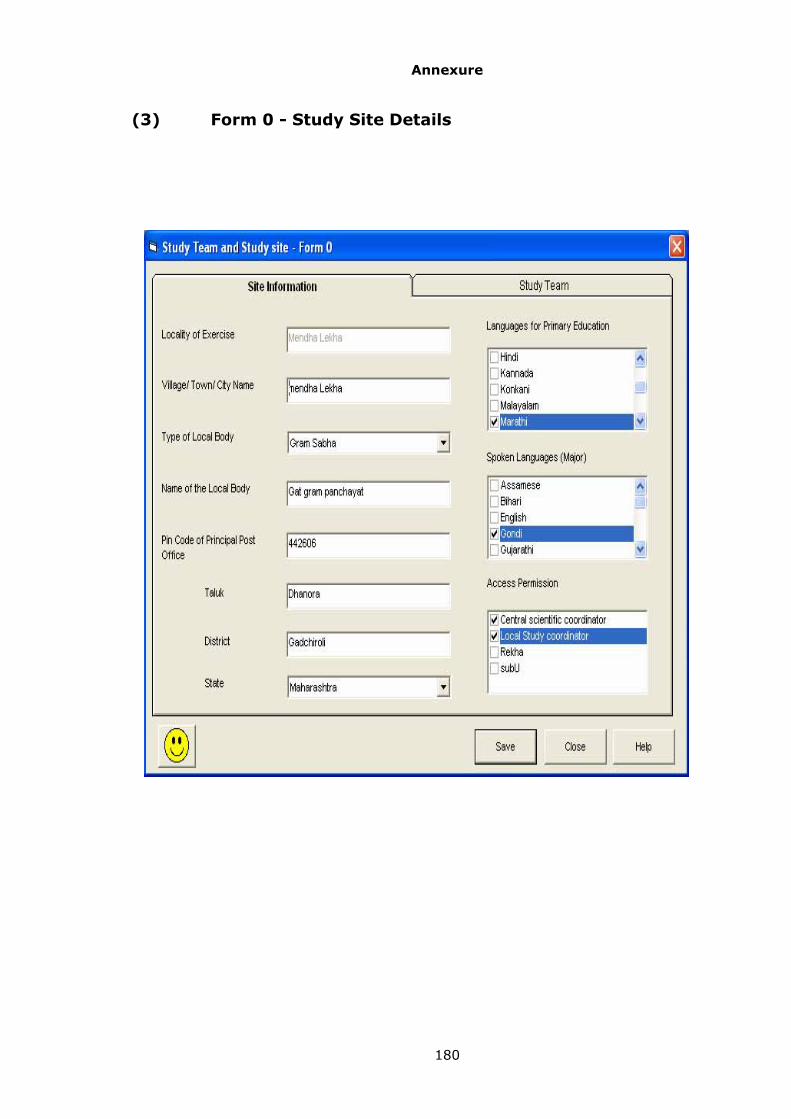
Annexure
180
(3) Form 0 - Study Site Details

Annexure
181
(4) Form 0 - Study Team Details

Annexure
182
(5) Photo Display

Annexure
183
(6) Form 1.1 and Form 1.2 - Activities (Insider and
Outsider)

Annexure
184
(7) Form 2.1 and Form 2.2 - Description of Local and
External User Groups
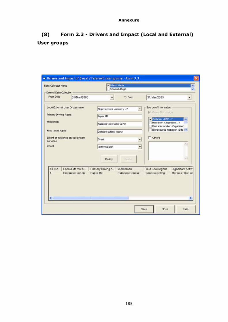
Annexure
185
(8) Form 2.3 - Drivers and Impact (Local and External)
User groups

Annexure
186
(9) Form 2.4 - Recording the Movement of Nomadic
Population

Annexure
187
(10) Form 2.4 - Recording the Movement of Nomadic
Population
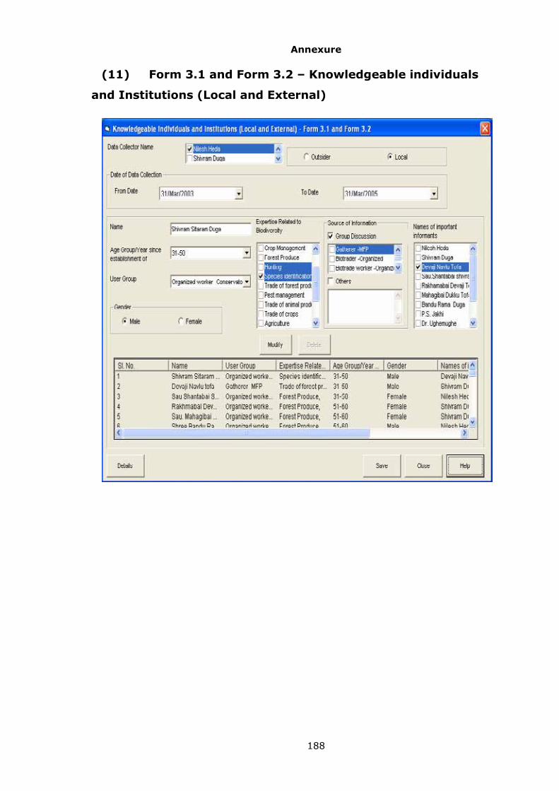
Annexure
188
(11) Form 3.1 and Form 3.2 – Knowledgeable individuals
and Institutions (Local and External)

Annexure
189
(12) Personal Details

Annexure
190
(13) Personal Details

Annexure
191
(14) Personal Details

Annexure
192
(15) Form 4.1 - LSE / WSE Types and Subtypes

Annexure
193
(16) Photo Display of LSE /WSE Types

Annexure
194
(17) Form 5.1 - Locally Known Life Forms

Annexure
195
(18) Photo Display of Locally known Life Forms

Annexure
196
(19) Form 6.1 - Functional Groups

Annexure
197
(20) Form 7.1a – Background Information

Annexure
198
(21) Form 7.1a – Background Information

Annexure
199
(22) Form 7.1b – Background Information

Annexure
200
(23) Form 7.1c – Background Information

Annexure
201
(24) Form 7.1c – Background Information

Annexure
202
(25) Form 7.1d – Background Information

Annexure
203
(26) Form 7.2 – Historical and Cultural information
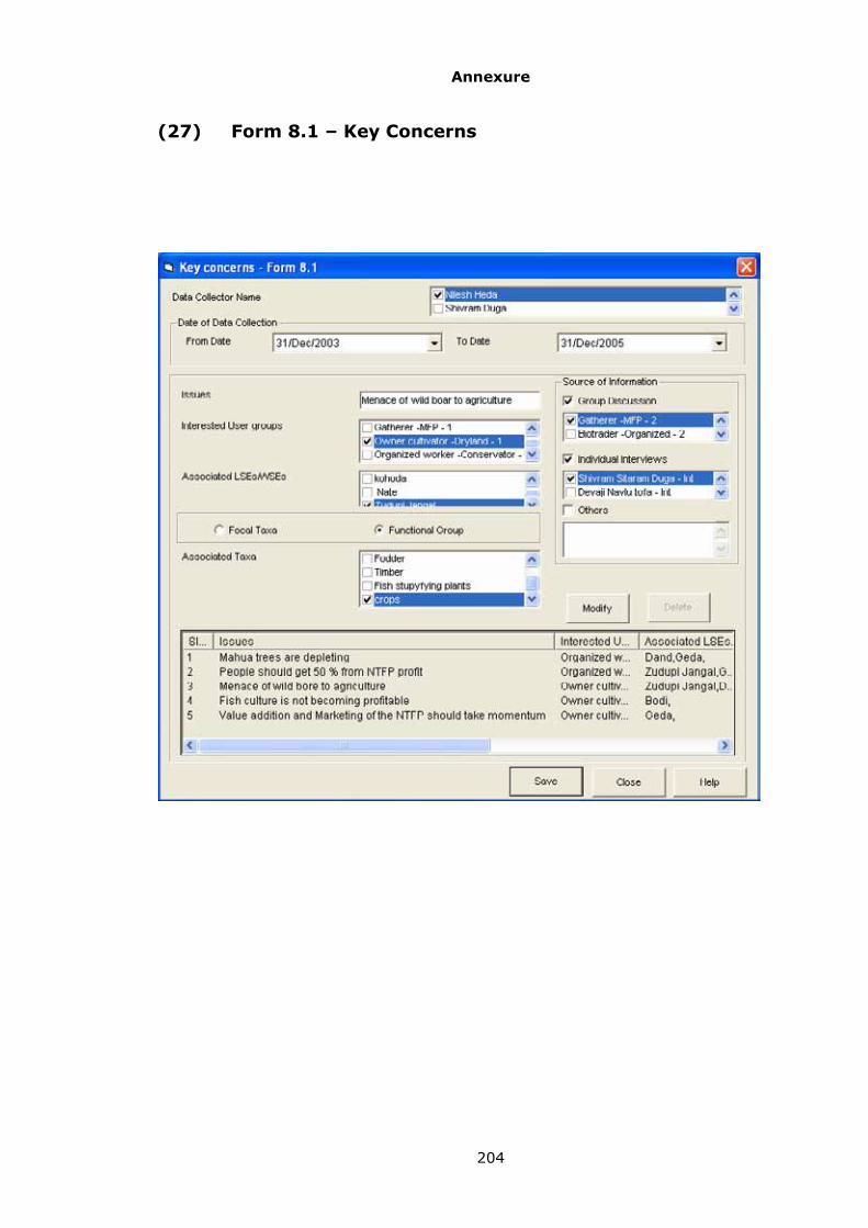
Annexure
204
(27) Form 8.1 – Key Concerns

Annexure
205
(28) Form 9.1A – Landscape Status and Dynamics
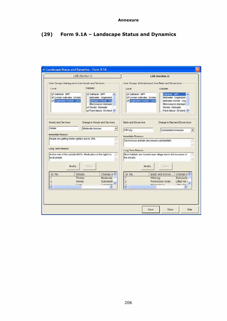
Annexure
206
(29) Form 9.1A – Landscape Status and Dynamics

Annexure
207
(30) Form 9.1B – Landscape Management

Annexure
208
(31) Form 9.2A – Waterscape Status and Dynamics

Annexure
209
(32) Form 9.2A – Waterscape Status and Dynamics

Annexure
210
(33) Form 9.2A – Waterscape Status and Dynamics

Annexure
211
(34) Form 9.2B – Waterscape Management

Annexure
212
(35) Form 10.1 – Focal Landscape Elements Field Survey

Annexure
213
(36) Form 10.2 – Focal landscape Elements Vegetation
Cover

Annexure
214
(37) Form 10.3 – Focal Waterscape Elements Field Survey
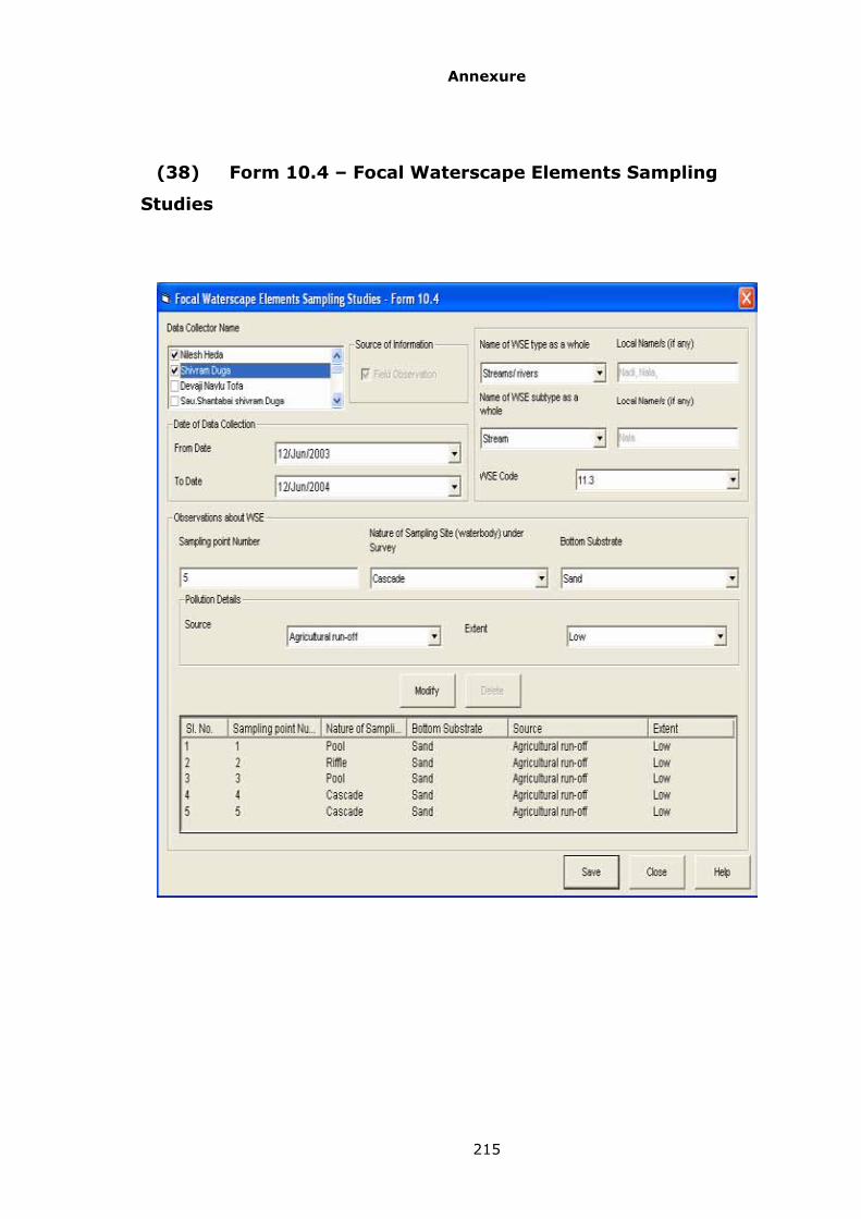
Annexure
215
(38) Form 10.4 – Focal Waterscape Elements Sampling
Studies

Annexure
216
(39) Form 11.1A –Focal Landscape Elements History

Annexure
217
(40) Form 11.1A –Focal Landscape Elements History

Annexure
218
(41) Form 11.1B –Focal Landscape Management

Annexure
219
(42) Form 11.2A –Focal Waterscape Elements History
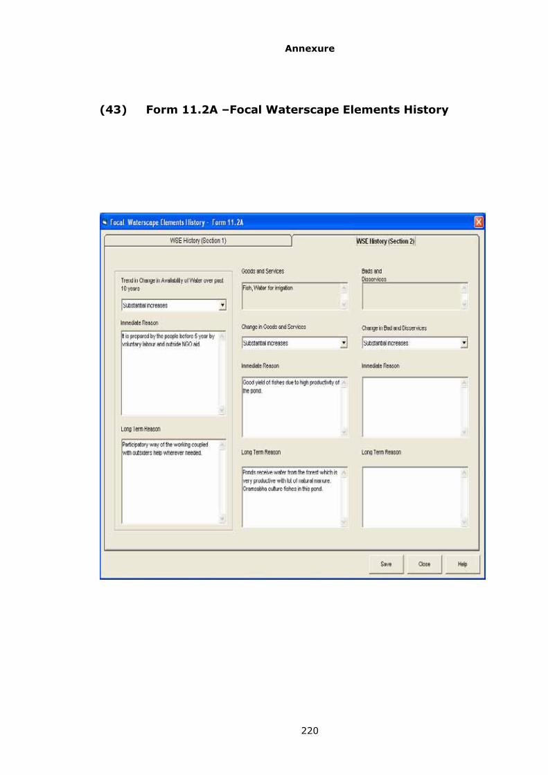
Annexure
220
(43) Form 11.2A –Focal Waterscape Elements History

Annexure
221
(44) Form 11.2B –Focal Waterscape Elements
Management

Annexure
222
(45) Form 12.1 – Focal Taxa Abundance Field Survey

Annexure
223
(46) Form 13.1 – Focal Taxa Status and Trends in
Abundance

Annexure
224
(47) Form 13.2 – Domesticated Biodiversity

Annexure
225
(48) Form 13.3 – Focal Taxa Status and Trends in Value or
Uses

Annexure
226
(49) Form 13.4A – Focal Taxa Status and Trends in Value or
Uses

Annexure
227
(50) Form 13.4B – Focal Taxa Management User Group
Perspective

Annexure
228
(51) Form 14.1B – Folk Knowledge

Annexure
229
(52) Form 14.1B – Folk Knowledge

Annexure
230
(53) Form 15.1 – Management Plan Components

Annexure
231
(54) An Example of the Hindi language PEBINFO screen shot

Annexure
232
(55) An Example of the Marathi language PEBINFO screen
shot

Annexure
233
(56) An Example of the Kannada language PEBINFO screen
shot