Earth Observation for Energy - HCP international · Earth Observation for Energy ... Clean energy...
73
Earth Observation for Energy International trends & developments How to promote earth observation applications? How to get funding? Capacity building 1
Transcript of Earth Observation for Energy - HCP international · Earth Observation for Energy ... Clean energy...

Earth Observation for Energy
International trends & developments
How to promote earth observation applications?
How to get funding?
Capacity building
1

0. Introduction
Mark Noort, consultant, project manager HCP international: consulting, marketing of earth observation Coordinator GEONetCab: project for promotion & capacity building of earth observation applications
2

3
Earth observation applications
• On the verge of reaching new user communities
• These new user communities need to be involved
• Weakest link / last mile aspects are important
• Marketing needed: promotion & capacity building

Life cycle of products & services
Initialization
System analysis & design
Rapid prototyping
System development
Implementation
Post-implementation
4
Assessment of business & funding opportunities
• Categories of environmental products & services
• Life cycle phase of product or service
• Regional context, level of technological & economic development
• Optimum marketing mix
5

1. International trends & developments in energy
6

• Increased attention for renewable energy
• Search for new energy sources (including biofuel)
• Increased attention for energy saving
• Anticipation on the possible effects of climate change
7
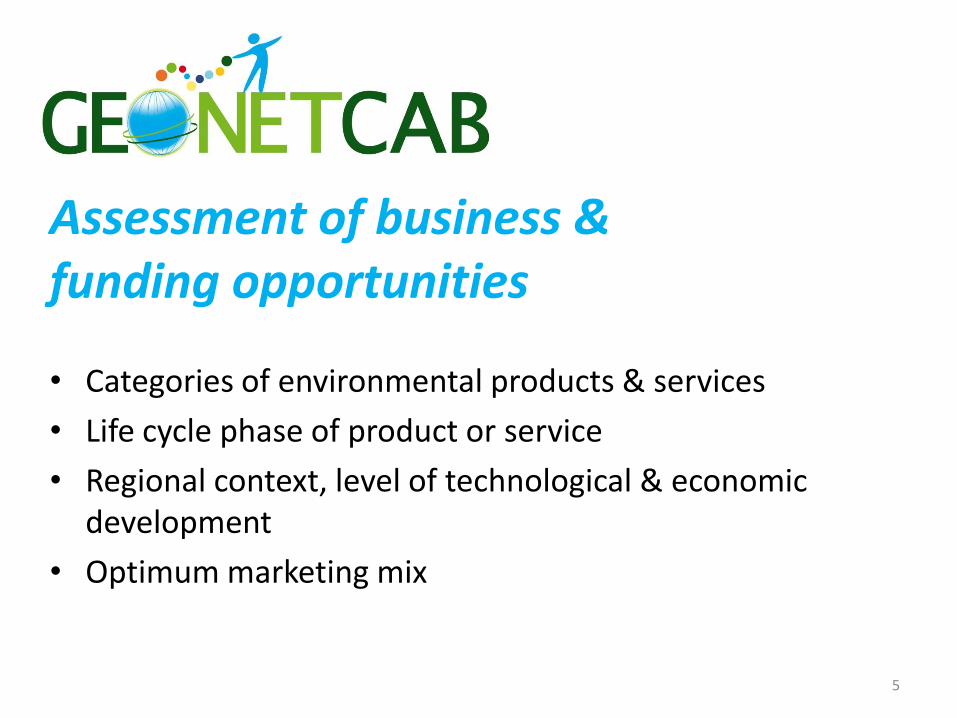
Trends
• Solar energy • Wind energy (onshore and land-based) • Wind energy (offshore) • Bioenergy • Hydropower • Geothermal energy
8
Renewable energy sources:
9
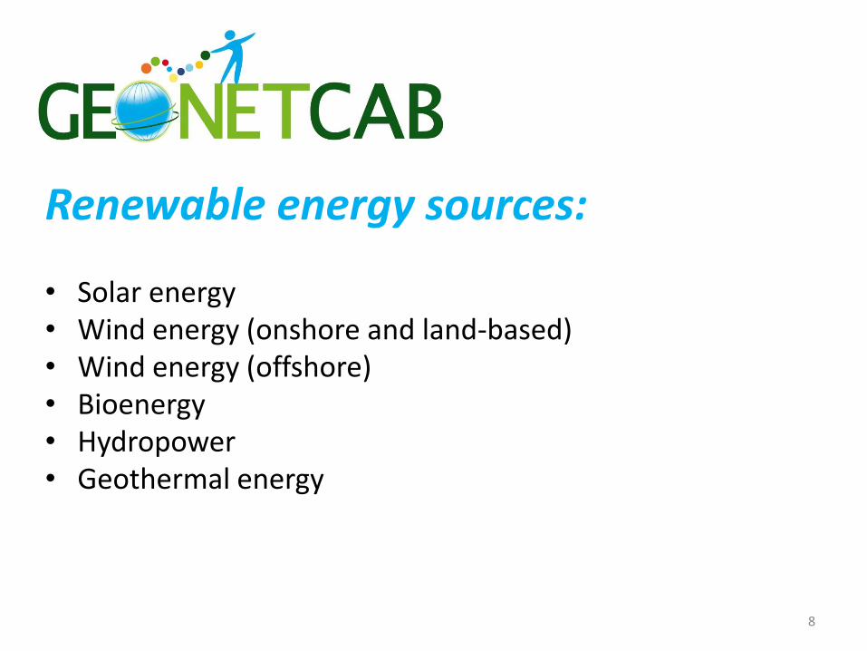
Solar energy
New renewable energy, Norwegian developments, Kan Energy AS (1998)
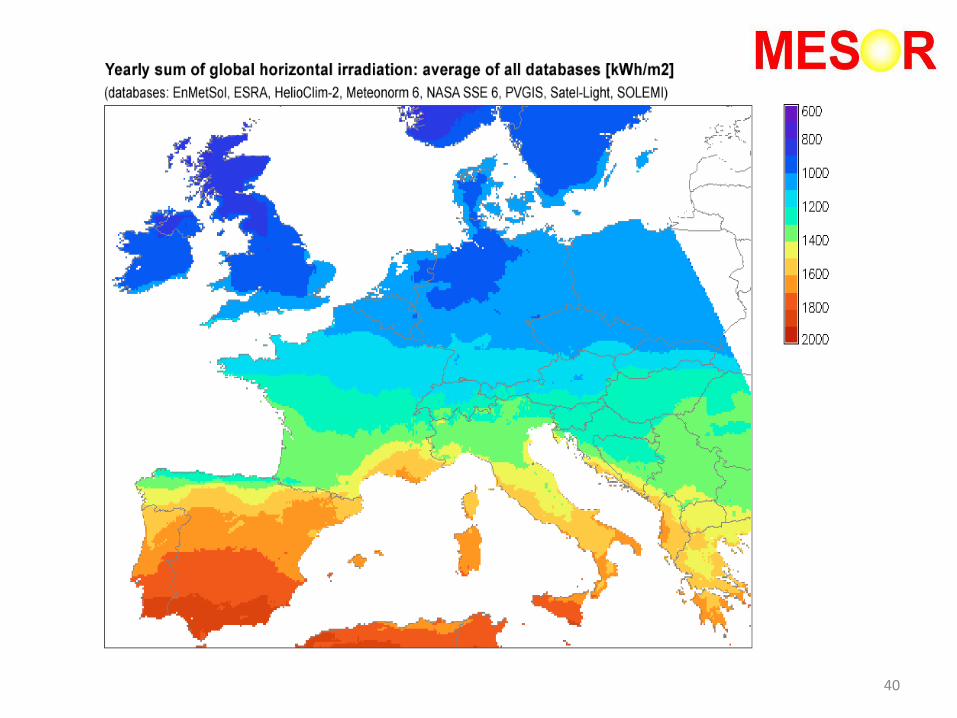
Yearly solar irradiation against a horizontal surface (kWh/m2)

10
Wind energy
New renewable energy resources, WEC (1994)
Global circulation of wind over the Earth
11
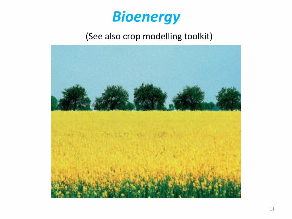
Bioenergy (See also crop modelling toolkit)
12
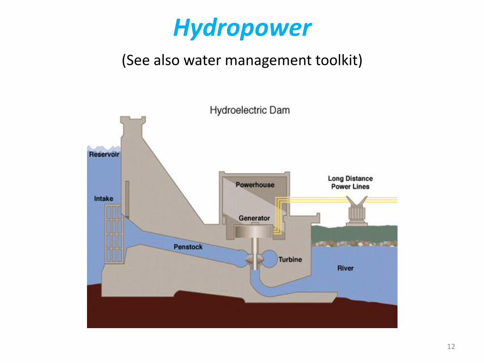
Hydropower (See also water management toolkit)

13
Geothermal energy
White dots: areas where geothermal projects are in operation Nemzer, M. , Geothermal education office (2000) http://geothermal.marin.org
World map of lithospheric boundary plates

(See also 4. Capacity building) Renewable energy projects handbook (WEC) Overview of renewable energy options, potential and main features of each type of renewable energy + political and financial considerations, project checklist and a description of the environmental credits acquisition process
Global Energy Information System www.worldenergy.org Case studies on renewable energy from different countries
Promise of renewables (CSIS) Commentary on trends, developments, problems: renewable is more expensive than fossil, but investment is growing
14
Renewable energy handbooks

15
Renewable energy outlook
World energy outlook 2008 reference scenario
Increase in world electricity generation from renewable energy
References solar energy:
Solar energy perspectives (IEA) Comprehensive overview: if you want use solar energy, start here!
Renewable energy essentials: Solar heating and cooling (IEA) Short overview of markets and potential
Renewable energy essentials: Concentrating solar thermal power (IEA) Short overview of markets and potential
Technology roadmap: Solar photovoltaic energy (IEA) Plan for future action, based on current and anticipated trends
Technology roadmap: Solar heating & cooling (IEA) Plan for future action, based on current and anticipated trends
16

References wind energy:
Technology roadmap: Wind energy (IEA) Plan for future action, based on current and anticipated trends and stressing the importance of standards for resource assessment, sharing of wind resource data and improving wind forecasting accuracy
Renewable energy essentials: Wind (IEA) Short overview of markets and potential
17

References bioenergy:
Biofuels: policies, standards and technologies (WEC) Overview of the current state of affairs, including sustainability criteria
Strong growth in biofuel market
Currently, two countries: Brazil and USA account for nearly 80% of global biofuels production. Both countries produce mainly bioethanol: USA from maize and Brazil from sugar cane.
Sustainable biofuel production practices would not hamper food and fibre production nor cause water or environmental problems but would actually enhance soil fertility.
Good practice guidelines: Bioenergy project development & biomass supply (IEA) Guide towards a sustainable and profitable approach
18
References hydropower & geothermal: Renewable energy essentials: Hydropower (IEA) Short overview of markets and potentials
Renewable energy essentials: Geothermal (IEA) Short overview of markets and potentials
19
References energy efficiency: Mind the gap: Energy efficiency (IEA) Comprehensive discussion of barriers and solutions with respect to achieving energy efficiency, based on agency theory
Technology roadmap: Energy-efficient buildings (IEA) Graphic visualization of roadmap and targets
20
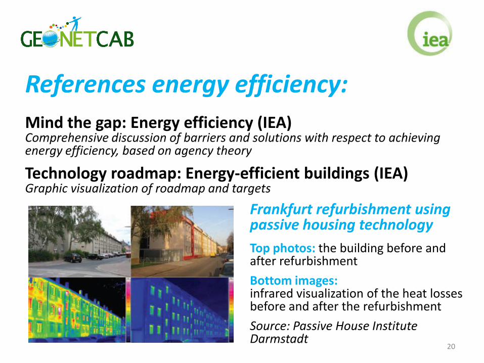
Frankfurt refurbishment using passive housing technology
Top photos: the building before and after refurbishment
Bottom images: infrared visualization of the heat losses before and after the refurbishment
Source: Passive House Institute Darmstadt

Not renewable, but interesting:
Shale gas, what’s new (WEC) Overview of the current state of affairs
Shale gas 2010 (WEC) Idem
Competition for strategic materials (CSIS) Commentary on availability of rare earths, also needed for production of renewable energy!
21
Climate change: Climate impact on energy systems (World Bank) Adaptation is essential: changing trends, increasing variability, greater extremes and large inter-annual variations in climate parameters are expected.
Better risk management and more resilient infrastructure are required. Increasing the capacity to use information is required, especially in developing countries -> see climate toolkit.
Observation and monitoring of hydro-meteorological and climate parameters for select energy uses are important, virtually all involve earth observation -> see climate toolkit.
Energy/water saving, demand-side management, energy storage, smart grids, decentralized energy structures, increased vehicle efficiency are important.
Observation networks in developing countries need to be upgraded to minimum WMO standard.
Case studies from Albania and Mexico
22
23
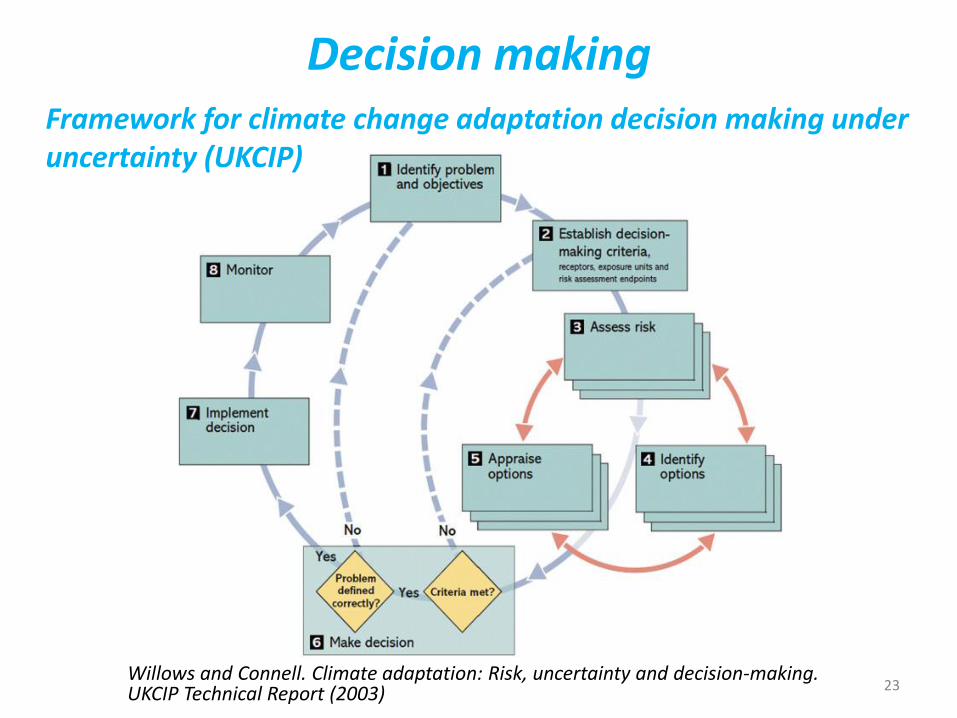
Decision making
Willows and Connell. Climate adaptation: Risk, uncertainty and decision-making. UKCIP Technical Report (2003)
Framework for climate change adaptation decision making under uncertainty (UKCIP)

2. Steps to promote earth observation for energy
24

State-of-the-art
Earth observation is new technology.
Learn technical skills, but when back in professional practice, it has to be put to good use.
That involves ‘selling’ it.
How to do that?
To whom? Could be your own boss, local authorities, communities, etc.
25

Categories of products and services
• Resource assessment for (renewable) energy
• Energy resources exploration support
• Pipeline monitoring
• Optimization of biofuel production (see crop modelling toolkit)
Niche markets:
• Sustainable building design
• Prediction of damaging geomagnetically induced currents (GICs)
• Effect of climate change on energy requirements
26

Earth observation comparative advantages
• Increased accuracy
• Cost reduction / increase of revenue
• Better planning
• General innovation
27
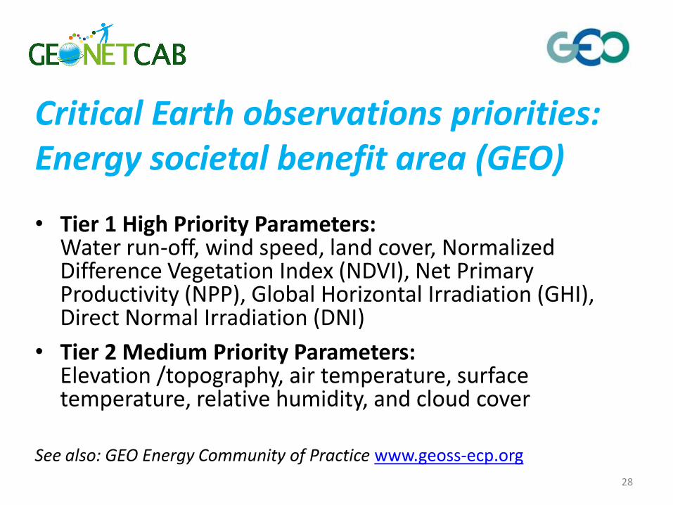
Critical Earth observations priorities: Energy societal benefit area (GEO)
• Tier 1 High Priority Parameters: Water run-off, wind speed, land cover, Normalized Difference Vegetation Index (NDVI), Net Primary Productivity (NPP), Global Horizontal Irradiation (GHI), Direct Normal Irradiation (DNI)
• Tier 2 Medium Priority Parameters: Elevation /topography, air temperature, surface temperature, relative humidity, and cloud cover
See also: GEO Energy Community of Practice www.geoss-ecp.org
28
29
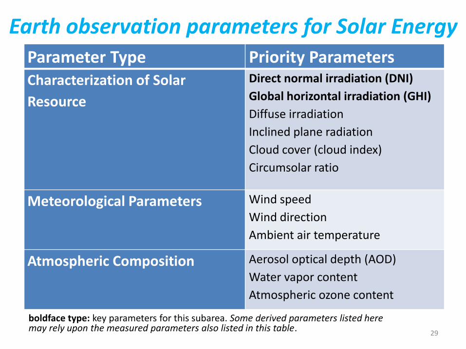
Earth observation parameters for Solar Energy
boldface type: key parameters for this subarea. Some derived parameters listed here may rely upon the measured parameters also listed in this table.
Parameter Type Priority Parameters Characterization of Solar
Resource
Direct normal irradiation (DNI)
Global horizontal irradiation (GHI)
Diffuse irradiation
Inclined plane radiation
Cloud cover (cloud index)
Circumsolar ratio
Meteorological Parameters Wind speed
Wind direction
Ambient air temperature
Atmospheric Composition Aerosol optical depth (AOD)
Water vapor content
Atmospheric ozone content

30
Earth observation parameters for Wind Energy Parameter Type Priority Parameters
Meteorological Parameters Wind speed
Wind direction
Vertical wind profile
Turbulence
Wind shear
Relative humidity
Ambient air temperature
Atmospheric pressure
Land Parameters Topography/elevation
Land cover
Surface roughness
Offshore Environment
Information
Wave height
Current speed
Tides
Bathymetry
Sea surface temperature boldface type: key parameters for this subarea. Some derived parameters listed here may rely upon the measured parameters also listed in this table.

31
Earth observation parameters for Bioenergy Parameter Type Priority Parameters Land information Land cover (including ecosystem type and
identification of specific crops)
Elevation/topography
Texture
Meteorological Parameters Normalized Difference Vegetation Index (NDVI)
Net Primary Productivity (NPP)
Evapotranspiration
Soil Moisture
Soil carbon content
Groundwater storage
Land Parameters Precipitation
Air temperature
Relative humidity
Surface temperature
Characterization of Solar Resource Direct normal irradiation (DNI)
Global horizontal irradiation (GHI)
Spectral distribution
Cloud cover (cloud index)
boldface type: key parameters for this subarea. Some derived parameters listed here may rely upon the measured parameters also listed in this table.

32
Earth observation parameters for Hydropower Parameter Type Priority Parameters Water Parameters Water run-off
Stream/river flow
Lake/reservoir height
Snow water equivalent
Groundwater storage
Near-surface water and sea-surface
temperature (for large lakes)
Meteorological Parameters Precipitation
Air temperature
Wind speed
Relative humidity
Pressure
Cloud cover
Land Parameters Topography/elevation
Land cover
Snow cover
Synthetic aperture radar images
boldface type: key parameters for this subarea. Some derived parameters listed here may rely upon the measured parameters also listed in this table.
33
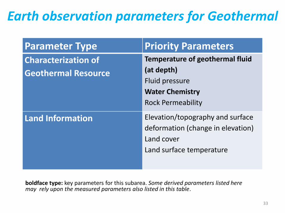
Earth observation parameters for Geothermal
Parameter Type Priority Parameters Characterization of
Geothermal Resource
Temperature of geothermal fluid
(at depth)
Fluid pressure
Water Chemistry
Rock Permeability
Land Information Elevation/topography and surface
deformation (change in elevation)
Land cover
Land surface temperature
boldface type: key parameters for this subarea. Some derived parameters listed here may rely upon the measured parameters also listed in this table.

Decision support Uses and limitations of observations, data, forecasts, and other projections in decision support for selected sectors and regions (CCSP)
With chapter of DSS for assessing hybrid renewable energy systems: description of HOMER (hybrid optimization model for electric renewables). HOMER makes use of earth observation data and a geospatial toolkit.
34
Resource assessment for (renewable) energy
35

Highlighting Earth’s solar resources from space (GMES) (1) Solar resource mapping and open access to GMES Sentinel data
36
Energy resource map: Annual solar irradiance in the Mediterranean region (kWh/m2). Source: DLR
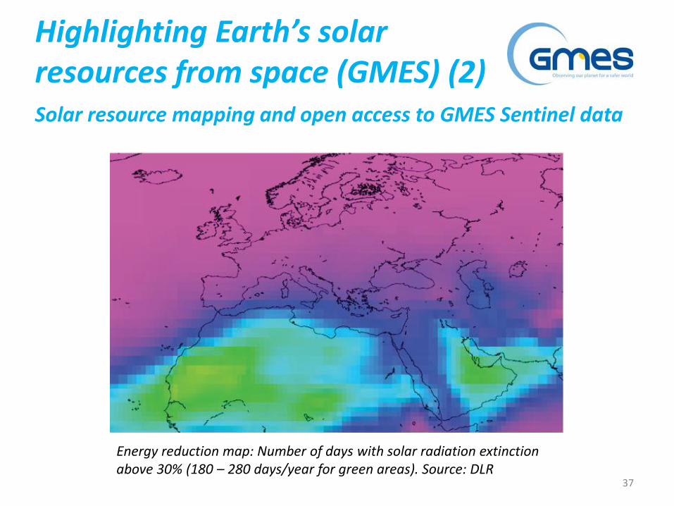
Highlighting Earth’s solar resources from space (GMES) (2) Solar resource mapping and open access to GMES Sentinel data
37
Energy reduction map: Number of days with solar radiation extinction above 30% (180 – 280 days/year for green areas). Source: DLR

Space supports Europe’s renewable energy future(GMES) Used: radar altimeters, scatterometers & image radar sensors
38
This coloured Envisat ASAR radar image, which is normally black and white, shows the wind fields over the North Sea around Denmark and northern Germany in September 2009.
Speed values range from 0–32 km per second.
Wind speeds and directions are indicated by the size and colour of the arrows.
Source: EEA & ESA
References ENVISOLAR & MESoR: ENVISOLAR space-based environmental information for solar energy industries Brochure with overview of services and examples, including services for investment decisions, plant management, utilities, time-series services for science and consulting and a description of the PV-calculator tool
MESoR (management and exploitation of solar energy knowledge) www.mesor.net continued at http://www.webservice-energy.org/
Description of solar resource products, summary of benchmarking results and examples of use (MESoR) Overview of and comparison (benchmarking) of different methods for measuring irradiation + 20 use cases
Needs for new solar radiation services to faster deploy the market for solar energy applications and optimize grid integration (MESoR) Recommendations for improvements in observations and forecasts
39
ENVI SOLAR
40

41
References RETScreen:
RETScreen international (Natural Resources Canada) Brochure on RETScreen initiative www.retscreen.net
Clean energy projects, RETScreen engineering & cases textbook Description of clean energy decision-making software; uses worldwide database of NASA satellite-derived meteorological data (NASA surface meteorology and solar energy dataset (SSE)) from a ten-year period (1983 – 1993)
Related information:
Solar energy data for developing countries (GEO-ECP) Short description of, and links to, SSE, Helioclim and SODA
42

Solar and Wind Energy Resource Assessment (SWERA) (1)
43
User manual

Solar and Wind Energy Resource Assessment (SWERA) (2)
44
User manual
References SWERA (1):
Results of solar resource assessments in the UNEP/SWERA project Article with summary of the results in the 13 SWERA countries
Global atlas for solar and wind energy end-user needs assessment Presentation of the end-user assessment for SWERA products (policy-makers, developers, NGOs/universities, global modelling community). SWERA is used as first data source (to identify high-potential areas), but is not enough for decision-making. More capacity building needed.
Solar and wind energy resource assessment (GEF) Success story with summary of SWERA achievements
45

References SWERA (2):
Enhancing information for renewable energy technology deployment in Brazil, China, and South Africa Description of resource assessment for solar and wind energy in the three countries + comparison between the countries
Terminal evaluation of UNEP GEF project solar and wind Evaluation report of the SWERA project with lessons learned and recommendations (establishment of a knowledge network)
User manual for SWERA: designing renewable resource assessment projects and using assessment products User manual for SWERA and related products + guidance on where to find information
46

Other references wind energy:
Satellite based services for the wind industry Article describing the use of EO data for wind farms (wind measurements over the ocean, wave statistics, tidal heights and currents, terrain roughness, orography)
Wind forecasting presentation (US) Description of forecasting systems, models, time horizons and forecast performance + recommendations to improve wind forecasting
Assessment of wind resources (Denmark) Presentation on the use of earth observation for WAsP (wind atlas analysis and application programme)
47
Other references: bird protection
Challenges and solutions of remote sensing at offshore wind energy developments How to improve bird protection in relation to wind energy projects; application of radar and GIS for off-shore and on-shore wind energy projects
Fuzzy modelling to identify areas of high conservation value for raptors: effectiveness of the network of protected areas in Andalucia (Spain) Master thesis on earth observation and GIS for bird protection and wind energy development schemes
See also: environmental management toolkit
48

Energy resources exploration support
49

African-European georesources observation system (AEGOS) Archive of public Africa-related georesources data
50
Landsat ETM+ satellite image of the Catanda carbonatite massif (Angola) superimposed on DEM

AEGOS references:
AEGOS Review of spin-off projects based on AEGOS, preparation of a road map for AEGOS test beds Description of 8 geological mapping initiatives in Africa
AEGOS: The spatial data infrastructure for georesources in Africa Overview presentation of the AEGOS initiative
Related article:
Multi- and hyperspectral geologic remote sensing: a review (ITC) Description of the state-of-the-art of remote sensing for geology, stressing the importance of validation, bridging the gap between earth observation and geology, a multidisciplinary approach and data continuity
51

One Geology:
Geological maps for more than 70 countries Including information on geothermal showcases in Australia and France, and the digital energy map of the UK www.onegeology.org
52
Initiatives, such as AEGOS and One Geology, also support energy resources assessment!
Pipeline monitoring
53
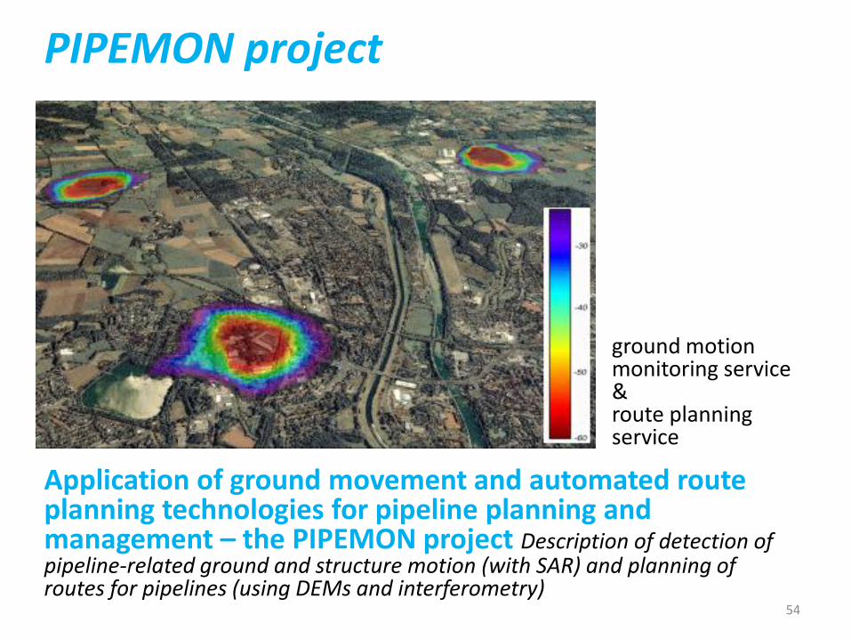
PIPEMON project
ground motion monitoring service & route planning service
54
Application of ground movement and automated route planning technologies for pipeline planning and management – the PIPEMON project Description of detection of pipeline-related ground and structure motion (with SAR) and planning of routes for pipelines (using DEMs and interferometry)

Other references:
Oil and gas spill and pipeline condition assessment using remote sensing (EPA) Overview of methodologies for pipeline monitoring in the US
Environmental Impacts of pipelines (ITC) Article describing the use of remote sensing for detection of seepage from pipelines
55

Other topic: geomagnetically induced currents
Power and pipelines (ground systems) Article on the effects of space weather (geomagnetically induced currents) on power lines and pipelines and what remote sensing can do about it
56
Possible business opportunities
• Further development and refinement of models and forecasts;
• Application of existing models and software tools to improve knowledge base and forecasting ability (particularly in developing countries);
• Use earth observation to compensate for lack of in-situ data (particularly in developing countries);
• Market opportunities both B2G and B2B.
57

Marketing of earth observation
Marketing of earth observation is difficult.
New technology, few big companies, lots of small ones.
Lots of reports describing the bottlenecks, like reliability, data access, data continuity, etc.
Means that relatively a lot of effort is needed to promote EO.
58

Points to keep in mind:
• Look for opportunities, where can you have most success in a short time: quick-wins.
• Target the right audience to start with: who would be interested and listen to you?
• Identify the problem that they are trying to solve: is it the same as yours?
• Learn to speak the same language. Example ‘lithospheric’: this is a term most politicians do not understand and do not care about. Use terms related to profits and losses.
• Look for examples from elsewhere (success stories): solutions that work and are affordable.
59

Be patient: introduction of new technology and / or applications takes time
60

3. How to get funding for your activities
61

Approach
• Share information on your subject (a thing you are doing) and think that is interesting for your contact, then look for the link. Could this solve a problem for your partner? Are adjustments necessary? Need other parties be involved? Take it from there.
• LEADS, LEADS, LEADS
62
How?
• Establish your network.
• Look for opportunities.
• Write a good proposal.
• Promise much, but not too much.
63

Proposal outline (more detailed version in separate document, see also www.geonetcab.eu )
1. Introduction / relevance
2. Objective(s)
3. Activities
4. Output
5. Management & evaluation
6. Risk assessment
7. Time schedule
8. Budget
Annexes
64

Other references
65
• Civicus: writing a funding proposal
• Michigan State University: guide for writing a funding proposal
• ESRI: writing a competitive GRANT application
• REC: project proposal writing
Again:
• SHARED PROBLEM • SHARED LANGUAGE • SHARED SOLUTION
If all else fails, try to link with a more popular (and easy to understand) topic.
66

4. Capacity Building
67
General
Marketing is promotion + capacity building.
Especially for the introduction of new technologies capacity building is important at all levels.
Capacity building is the instrument to increase self-sufficiency and make solutions work.
68

Think of: • Different instruments for different levels: workshops for
decision makers and awareness raising, detailed technical training for professionals.
• Provide follow-up. Getting funding for good capacity building is difficult: everybody agrees that it is important, but nobody has time.
• Training is usually part of funding of big projects that are managed by big companies or ministries, as a consequence capacity building is forgotten (in the end).
• Aim at small budgets that are available without having to tender.
69

Examples & references MESoR training seminar on solar radiation services Presentations from the MESoR training seminar + use cases See also MESoR user handbook & RETScreen engineering textbook AEGOS Inventory of available curricula of training centers and practices Overview of IT, data management, GIS, RS and web applications courses (Europe, Africa, distance)and thermal infrared AEGOS Concept note about the needs in capacity building and training Overview of competencies required to work with the AEGOS data infrastructure and the existing gaps in Africa
70

Examples & references Wind energy handbook (Wiley) Everything you need to know… Wind resource assessment handbook (US) Do-it-yourself handbook for wind energy, including required parameters (from the pre-EO age) Capacity building output of the EnerGEO project www.energeo-project.eu GEONetCab capacity building web www.geonetcab.eu Compilation of tutorials, references, open-source software, etc. GEO Portal: www.earthobservations.org
71

More references A Rough Google Earth Guide MEASURE Evaluation Global Positioning System Toolkit (USAID) Handbook of Research on Developments and Trends in Wireless Sensor Networks: From Principle to Practice
72

Further details:
Contact: Mark Noort
www.geonetcab.eu
73