FALWEB F uzzy A ggregated L inkages W ithin E nvironmental B ounds
DUE DILIGENCE FOR THE LIFE CYCLE OF REAL ESTATE www.emgcorp.com
ENVIRONMENTAL A S S E S S M E N T
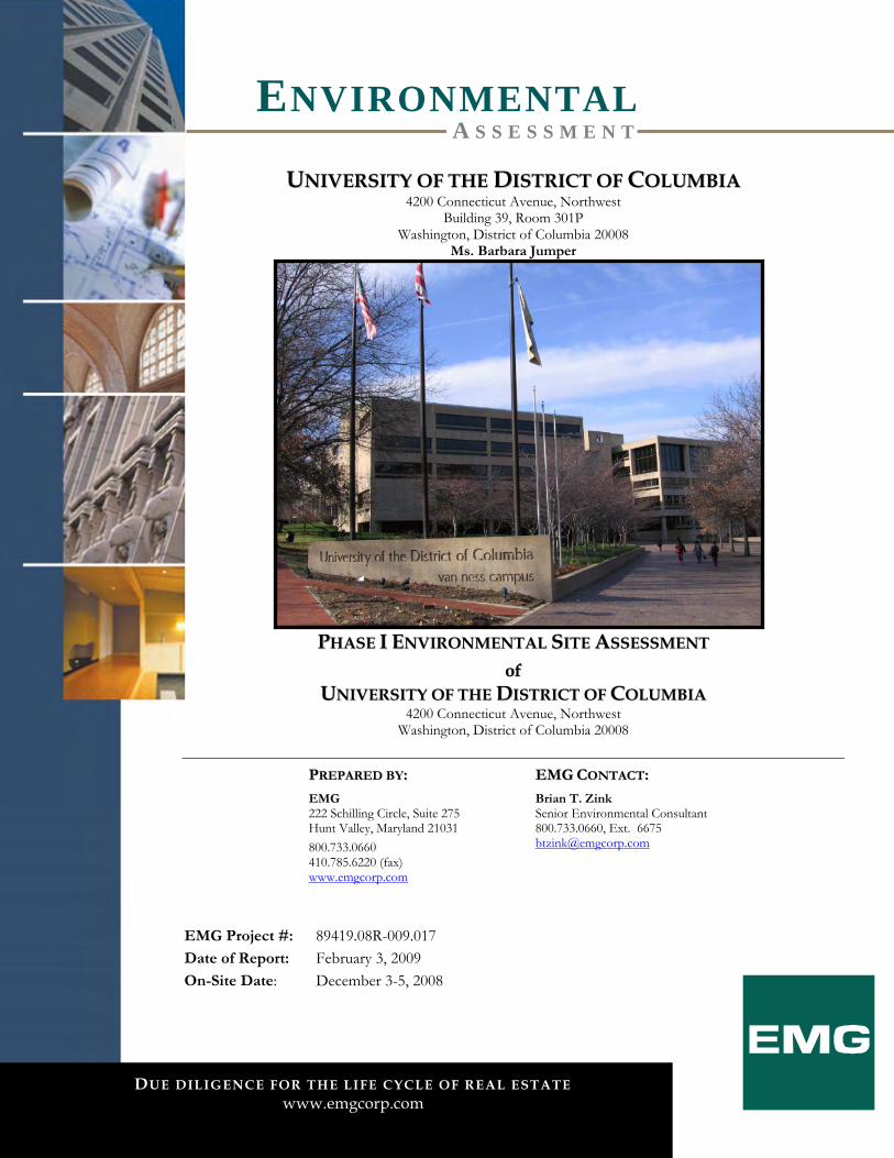
UUNNIIVVEERRSSIITTYY OOFF TTHHEE DDIISSTTRRIICCTT OOFF CCOOLLUUMMBBIIAA 4200 Connecticut Avenue, Northwest
Building 39, Room 301P Washington, District of Columbia 20008
Ms. Barbara Jumper
PPHHAASSEE II EENNVVIIRROONNMMEENNTTAALL SSIITTEE AASSSSEESSSSMMEENNTT ooff
UUNNIIVVEERRSSIITTYY OOFF TTHHEE DDIISSTTRRIICCTT OOFF CCOOLLUUMMBBIIAA 4200 Connecticut Avenue, Northwest
Washington, District of Columbia 20008
PPRREEPPAARREEDD BBYY::
EMG 222 Schilling Circle, Suite 275 Hunt Valley, Maryland 21031 800.733.0660 410.785.6220 (fax) www.emgcorp.com
EEMMGG CCOONNTTAACCTT::
Brian T. Zink Senior Environmental Consultant 800.733.0660, Ext. 6675 [email protected]
EMG Project #: 89419.08R-009.017 Date of Report: February 3, 2009
On-Site Date: December 3-5, 2008

8899441199 .. 0088RR-- 000099 .. 001177
DUE DILIGENCE FOR THE LIFE CYCLE OF REAL ESTATE. 800.733.0660 • www.emgcorp.com
A S S E S S M E N T E N V I R O N M E N T A L
PP RR OO JJ EE CC TT SS UU MM MM AA RR YY
University of the District of Columbia
4200 Connecticut Avenue, Northwest
Washington, District of Columbia 20008
Assessment Component Acceptable Routine Solution Phase II Estimated Cost §
Reference Section Page
Historical Review (2) N/A 6 17 Operational Activities 7.1 24 Hazardous Materials 7.2 25 Waste Generation 7.3 26 PCBs 7.4 27 Asbestos (1) Document Review:
See below Survey:
$31,000
7.5 27
Tanks/Pipelines (2) N/A 7.6 28 Surface Areas 7.7 29 Mold (3) $25,200 7.8 29 Regulatory Database Review
(2) N/A 9 33
Adjacent Properties 10 40 Conditions noted in the Project Summary Table are representative of the overall conditions of the property. There may be more detail on specific assessment components in the report text, therefore the Project Summary Table should not be used as a stand alone document. § Costs depicted are for investigation/program development activities. Remediation costs, if required, will be identified as a result of the activities. (1) EMG recommends that any additional ACM documentation be provided for review and comment. The cost for document
review is $700 plus $175 per hour after the first four hours. If this documentation is not available or is insufficient, additional investigation in the form of a comprehensive asbestos survey may be necessary to more fully evaluate the potential for ACM at the Project.
(2) EMG recommends continued groundwater sampling and laboratory analysis in accordance with applicable regulations and requirements in order to achieve regulatory closure.
(3) Prior to remediation by personnel specifically trained in the handling of hazardous materials, a mold assessment should be conducted by a health and safety professional with experience performing microbial investigations. Additional information about the source of the moisture is included in EMGs Property Condition Assessment (PCA) reports.
8899441199 .. 0088RR-- 000099 .. 001177
DUE DILIGENCE FOR THE LIFE CYCLE OF REAL ESTATE. 800.733.0660 • www.emgcorp.com
A S S E S S M E N T E N V I R O N M E N T A L
TT AA BB LL EE OO FF CC OO NN TT EE NN TT SS
1. Certification .............................................................................................................1 2. Executive Summary................................................................................................ 2
2.1. Findings/Conclusions ........................................................................................................... 3 2.2. Recommendations/Opinions .............................................................................................. 8
3. Survey Approach/Purpose ....................................................................................10 3.1. Data Gaps ............................................................................................................................. 12
4. User Provided Information....................................................................................13 4.1. User Engaged Environmental Cleanup Liens and Activity And Use Limitation
(AUL) Review ................................................................................................................. 13 4.2. User Questionnaire .............................................................................................................. 13 4.3. Reason for Assessment ....................................................................................................... 13
5. Project Location/Description ...............................................................................14 5.1. Project Description.............................................................................................................. 14 5.2. Miscellaneous Systems ........................................................................................................ 14 5.3. Environmental Setting ........................................................................................................ 15 5.3.1. Topography........................................................................................................................ 15 5.3.2. Wetlands............................................................................................................................. 15 5.3.3. Floodplain .......................................................................................................................... 16 5.3.4. Soils/Geology.................................................................................................................... 16 5.3.5. Groundwater Hydrology ................................................................................................. 16
6. Historical Review ..................................................................................................17 6.1. Chain of Title........................................................................................................................ 17 6.2. Prior Use Interviews............................................................................................................ 17 6.3. Local and/or State Government Agency Record Review/Interviews........................ 17 6.4. Historical Maps .................................................................................................................... 18 6.5. Aerial Photography .............................................................................................................. 20 6.6. Previous Investigations/Assessments .............................................................................. 21 6.7. Plans and Specifications...................................................................................................... 22 6.8. Historical Summary ............................................................................................................. 22
7. Project Reconnaissance........................................................................................ 24 7.1. Operational Activities/Noteworthy Tenants .................................................................. 24 7.2. Hazardous Materials/Petroleum Products Storage and Handling............................... 25 7.3. Waste Generation, Treatment, Storage, and Disposal ................................................... 26 7.4. Polychlorinated Biphenyls (PCBs) .................................................................................... 27 7.5. Asbestos-Containing Materials (ACM)............................................................................. 27 7.6. Facility Storage Tanks and Pipelines (above or below ground).................................... 28 7.7. Surface Areas ........................................................................................................................ 29 7.8. Mold ....................................................................................................................................... 29
8. Interviews ..............................................................................................................31 8.1. Key Site Manager ................................................................................................................. 31 8.2. Owner .................................................................................................................................... 31 8.3. User ........................................................................................................................................ 31 8.4. Occupants ............................................................................................................................. 31
8899441199 .. 0088RR-- 000099 .. 001177
DUE DILIGENCE FOR THE LIFE CYCLE OF REAL ESTATE. 800.733.0660 • www.emgcorp.com
A S S E S S M E N T E N V I R O N M E N T A L
8.5. Past Owners, Operators, and Occupants......................................................................... 32 8.6. Owners Or Occupants of Adjacent or Nearby Property .............................................. 32 8.7. Interviews with Others........................................................................................................ 32
9. Regulatory Database Review................................................................................ 33 10. Adjacent Properties .............................................................................................. 40 11. Appendices ............................................................................................................41
8899441199 .. 0088RR-- 000099 .. 001177
DUE DILIGENCE FOR THE LIFE CYCLE OF REAL ESTATE. 800.733.0660 • www.emgcorp.com
1
A S S E S S M E N T E N V I R O N M E N T A L
11 .. CC EE RR TT II FF II CC AA TT II OO NN
EMG has completed a Phase I Environmental Site Assessment of the University of the District of Columbia (the “Project”), located at 4200 Connecticut Avenue, Northwest in Washington, District of Columbia 20008. The assessment was performed at the Client’s request using the methods and procedures consistent with good commercial and customary practice designed to conform with acceptable industry standards. This report has been prepared on behalf of and exclusively for the use of The University of the District of Columbia for the purpose stated within Section 2.1. of this report. The report, or any excerpt thereof, shall not be used by any party other than The University of the District of Columbia or for any other purpose than that specifically stated in our agreement or within Section 2.1. of this report without the express written consent of EMG. Any reuse or distribution of this report without such consent shall be at The University of the District of Columbia and the recipient’s sole risk, without liability to EMG. In expressing the opinions stated in this report, EMG has exercised the degree of skill and care ordinarily exercised by a reasonable prudent environmental professional in the same community and in the same time frame given the same or similar facts and circumstances. Documentation and data provided by the Client, designated representatives of the Client or other interested third parties, or from the public domain, and referred to in the preparation of this assessment, have been used and referenced with the understanding that EMG assumes no responsibility or liability for their accuracy. The independent conclusions represent our professional judgment based on information and data available to us during the course of this assignment. Factual information regarding operations, conditions, and test data provided by the Client or their representative has been assumed to be correct and complete. The conclusions presented are based on the data provided, observations, and conditions that existed on the date of the on-site visit. If you have any questions regarding this report, please contact the Senior Environmental Consultant listed on the cover page of this report.
Researched by: Clarissa Lobaugh, Project Manager
Surveyed by: Clarissa Lobaugh, Project Manager
Written by: Clarissa Lobaugh, Project Manager
I declare that, to the best of my professional knowledge and belief, I meet the definition of Environmental Professional as defined in §312.10 of 40 CFR 312. I have the specific qualifications based on education, training, and experience to assess a property of the nature, history, and setting of the Project. I have developed and performed the all appropriate inquiries in conformance with the standard and practices set forth in 40 CFR Part 312.
Reviewed by:
Brian T. Zink, Senior Environmental Consultant
8899441199 .. 0088RR-- 000099 .. 001177
DUE DILIGENCE FOR THE LIFE CYCLE OF REAL ESTATE. 800.733.0660 • www.emgcorp.com
2
A S S E S S M E N T E N V I R O N M E N T A L
22 .. EE XX EE CC UU TT II VV EE SS UU MM MM AA RR YY
EMG performed a Phase I Environmental Site Assessment, that included on-site observations of the accessible areas of the University of the District of Columbia (the “Project”), from December 3 to 5, 2008. The Project is located at 4200 Connecticut Avenue, Northwest in Washington, District of Columbia 20008, and is approximately 21.8 acres. The Project, originally constructed in the 1970s, is currently an academic facility consisting of eight buildings, including: - Building 32 (five levels) occupied by the Mathematics Department and reportedly constructed in 1974-
1975. - Building 38 (six levels) occupied by Student Services and the Law Department and reportedly constructed
in 1974-1975. - Building 39 (six levels) occupied by Administrative and Financial Aid and reportedly constructed in 1974-
1975. - Building 41 (seven levels) occupied by the Arts and Library Department and reportedly constructed in
1979-1980. - Building 42 (five levels) occupied by the Engineering Department and reportedly constructed in 1978-
1979. - Building 43 (three levels) used as the Physical Plant and reportedly constructed in 1978. - Building 44 (seven levels) occupied by the Life Sciences Department and reportedly constructed in 1980. - Two-level underground parking garage reportedly constructed in 1979-1981. Current facility operations include the maintenance and operations of an academic facility, including but not limited to classrooms, laboratories, and offices. Prior to construction of the current improvements, the Project was a part of the property occupied by the National Bureau of Standards. Properties in the general vicinity of the Project include residential and commercial land uses. The following summarizes the independent conclusions representing EMG’s best professional judgment based on information and data available to us during the course of this assignment. Factual information regarding operations, conditions, and test data provided by the Client, owner, or their representative have been assumed to be correct and complete. Additionally, the conclusions presented are based on the conditions that existed at the time of the assessment. We have performed a Phase I Environmental Site Assessment in conformance with the scope and limitations of ASTM Practice E 1527-05 of 4200 Connecticut Avenue, Northwest in Washington, District of Columbia 20008. Any exceptions to, or deletions from, this practice are described in Section 3. of this report. This assessment has revealed no evidence of Recognized Environmental Conditions (RECs) in connection with the Project, except for the following: The Project formerly contained three 30,000-gallon #2 fuel oil UST systems that were used by the campus
physical plant. A release from these USTs was identified in January of 1997, which resulted in the removal of the USTs and the initiation of remediation activities at the Project. Please see the Storage Tanks/Pipelines and Regulatory Review sections below for further discussion.
8899441199 .. 0088RR-- 000099 .. 001177
DUE DILIGENCE FOR THE LIFE CYCLE OF REAL ESTATE. 800.733.0660 • www.emgcorp.com
3
A S S E S S M E N T E N V I R O N M E N T A L
In addition, the following on-site environmental items of note were identified: Suspect ACM in the form of resilient floor tiles/mastic, sheet flooring, ceiling tiles, drywall/joint
compound, spray applied fireproofing, pipe wrap, insulation, and roofing materials were visually identified during the on-site assessment. Please see the Asbestos-Containing Materials section below for further discussion.
Suspect mold and water damage were visually observed in multiple areas of the Project during the assessment. Please see the Mold section below for further discussion.
A summary of the findings for this assessment are described below.
22 .. 11 .. FF II NN DD II NN GG SS //CC OO NN CC LL UU SS II OO NN SS
Historical Review (Section 6) The review of the historical data available for the Project and surrounding area identified the following
circumstances of environmental concern: − The Project was historically occupied by a portion of the property used by the National Bureau of
Standards, which oversaw multiple laboratories at the Project. In addition, tunnels that were reportedly used by the National Bureau of Standards remain under the Project and were inaccessible during the assessment; therefore, a determination could not made as to whether or not the activities in these tunnels, if any, could impact the environmental integrity of the Project. It is possible based on the past uses of the Project as the National Bureau of Standards that the subsurface has been impacted. However, the Project buildings have below grade levels, and during excavation of the below grade levels it is anticipated that any potential associated contamination would have been encountered and removed. Also, because the National Bureau of Standards buildings were removed at least 30 years ago, a natural degradation of any contamination has likely occurred. In addition, there does not appear to be an immediate health risk to the occupants of the Project from this historical use since the Project is serviced by public water and sewer systems and the entire site is covered with relatively impermeable surfaces including the building and sidewalks. Although there is a potential that there has been impact to the subsurface from the past uses, it is unlikely that this poses a significant environmental risk to the operators/occupants of the Project, and no further action or investigation is recommended at this time. However, if additional information is needed regarding this former use and its potential for impact to the Project, further evaluation, in the form of a subsurface investigation, would be necessary.
Operational Activities (Section 7.1) EMG observed the following environmental concerns associated with the operational activities at the
Project: − Physical plant in Building 43 heating and cooling processes. − Chemistry academic laboratories in Building 44 and 42. − Biology academic laboratories in Building 44. − Physics academic laboratories in Building 44. − Radiology academic laboratories in Building 44. − Respiratory academic laboratory in Building 44. − Morgue located in Building 44.
8899441199 .. 0088RR-- 000099 .. 001177
DUE DILIGENCE FOR THE LIFE CYCLE OF REAL ESTATE. 800.733.0660 • www.emgcorp.com
4
A S S E S S M E N T E N V I R O N M E N T A L
− Asphalt degradation laboratory in Building 42. − Photography academic laboratories in Building 41 and Building 42. − Printing shop in Building 42. − Health Clinic in Building 44.
Please refer to the Hazardous Materials/Petroleum Products and Wastes discussions below for information on the potential hazards to the Project from these operations.
Hazardous Materials/Petroleum Products (Section 7.2) The Project is involved in the use of hazardous materials and petroleum products in the form of routine
janitorial/maintenance supplies, water treatment chemicals for heating and cooling purposes, fuel oil for heating and cooling purposes, hydraulic oil for machinery, refrigerants for heating and cooling purposes, oxygen and acetylene for welding, propane for forklifts, diesel fuel for emergency generators, academic laboratory chemicals and solvents, developer and fixer for X-ray and photograph development, and oxygen for medical use. In addition, the Project utilizes small quantities of various hazardous materials in chemistry laboratories for educational purposes. The identified materials appear to be properly stored. The materials observed do not appear to pose a hazard to the Project, provided they continue to be used as designed, are properly handled, and all regulations regarding their use are followed.
Wastes (Section 7.3) The Project generates hazardous waste in the form of PCBs, waste trichloethylene, waste oxidizing liquids,
waste corrosive liquids, waste flammable liquids, waste toxic organic liquids, waste toxic organic solids, and florescent light tubes, medical waste in the form of bio-hazardous media and sharps, and regulated waste in the form of refrigerants and spent x-ray and photograph developer and fixer, as well as non-hazardous solid and liquid wastes, including cooking grease. Generated wastes appear to be stored and disposed of properly; with the exception of spent film developing chemicals (e.g., developers, stabilizers, bleaches, and film fixer) that are not run through a silver recovery system before they are discharged to the public sewer system. According to Ms. Tamiko Bryant, the Project does not currently have a permit for this activity. EMG recommends that waste materials be handled according to appropriate industry standards and all applicable federal, state, and local regulations.
Polychlorinated Biphenyls (PCBs) (Section 7.4) EMG identified utility-owned transformers which are not classified regarding PCB content. This
equipment appeared to be in good condition with no evidence of leaks. The utility is the financially responsible party for maintenance of the transformers. No further action or investigation is recommended regarding the transformers at the Project.
The Project also uses secondary electrical service from privately owned “dry type” step-down transformers. Dry type transformers do not use oils for cooling purposes; therefore, these transformers are not expected to contain PCBs.
The Project maintains one hydraulic elevator, which is located in Building 38. Because the unit was installed prior to 1978 (the USEPA banned the manufacturing of PCB-containing hydraulic fluid in 1976, and the manufacture of PCBs ceased in 1977), EMG is of the opinion that the elevator hydraulic fluid potentially contains PCBs. No visual indication of leakage was observed in the area of the elevator operating equipment. The hydraulic elevator unit at the Project should be periodically inspected for leakage. If leakage is identified, the unit should be repaired and any fluid or fluid-soaked waste disposed of in accordance with applicable federal, state, and local regulations.
8899441199 .. 0088RR-- 000099 .. 001177
DUE DILIGENCE FOR THE LIFE CYCLE OF REAL ESTATE. 800.733.0660 • www.emgcorp.com
5
A S S E S S M E N T E N V I R O N M E N T A L
A hydraulic trash compactor is located at the Project. PCB-containing hydraulic fluid has not been manufactured since 1977. Therefore, based on the date of installation, PCB-containing hydraulic fluid is not likely to be found in the operating system. No visual indication of leakage was observed in the area of the equipment. No further action or investigation is recommended regarding the trash compactor at the Project.
Asbestos-Containing Materials (ACM) (Section 7.5) Suspect ACM in the form of resilient floor tiles/mastic, sheet flooring, ceiling tiles, drywall/joint
compound, spray applied fireproofing, pipe wrap, insulation, and roofing materials were visually identified during the on-site assessment. No samples were collected based on the Scope of Work. With the exception of a partial asbestos survey for Building 43, documentation of asbestos sampling was not provided for review during the site assessment. The Limited Hazardous Building Materials Survey Report completed by MACTEC Engineering and Consulting, Inc. (MACTEC) for a portion of Building 43, was done to identify ACM and lead-containing surface coatings in boiler components and associated piping that would be impacted during the boiler replacement. Skim coat mud on fiberglass pipe insulation, boiler stack exhaust insulation, boiler door insulation, interior boiler fire brick, and debris were sampled during the inspection. The laboratory analysis indicated that the skim coat mud on the fiberglass pipe insulation associated with the medium pressure steam and feed pipes contained 2-3% Chrysotile asbestos. Results for the other suspect materials sampled by MACTEC were “none detected”. MACTEC recommended that the ACM mud on fiberglass pipe insulation associated with the boiler piping be removed by a qualified asbestos abatement contractor licensed in the District of Columbia prior to being impacted by renovation activities. EMG recommends that any additional ACM documentation be provided for review and comment. If this documentation is not available or is insufficient, additional investigation in the form of a comprehensive asbestos survey may be necessary to more fully evaluate the potential for ACM at the Project.
Storage Tanks/Pipelines (Section 7.6) The Project formerly contained three 30,000-gallon #2 fuel oil underground storage tank (UST) systems
that were located adjacent to the north of the Physical Plant building, in the northeastern portion of the Project. Interruptible natural gas also serviced the physical plant as a heating fuel. On or about January 18, 1997, #2 fuel oil was detected in the surface water and along the banks of nearby Soapstone Creek. Subsequent investigations determined that the #2 fuel oil was being released to the creek from a storm drain system that was traced back to the physical plant area of the University of the District of Columbia. Oil sorbent booms and pads were used in the creeks and storm drain systems, and petroleum contaminated soils were excavated in January 1997. Monitoring wells were installed and results of laboratory analyses indicated TPH concentrations of 840 to 4,300 mg/kg in soil samples and benzene, toluene, ethylbenzene, total xylenes, total BTEX, and naphthalene above detection limits in groundwater samples. Free phase fuel oil was recovered via manual bailing and placed in recovery drums.
The three 30,000-gallon #2 fuel oil USTs were removed from the ground on February 13-21, 1997. A total of 13,000 gallons of fuel oil and contaminated groundwater were recovered from the excavation with vacuum trucks and 2,007.33 tons of petroleum contaminated soil was excavated and removed for off-site disposal. An additional 633.76 tons of petroleum contaminated soil and 11,700 gallons of fuel oil and contaminated groundwater were removed from the Project from February 22-26, 1997. The former UST area was re-filled with non-contaminated, compacted stone and soil. Impermeable seals were placed on the storm drain to prevent “flushing” of free and dissolved phase contaminants from the Project to potential receptor areas.
8899441199 .. 0088RR-- 000099 .. 001177
DUE DILIGENCE FOR THE LIFE CYCLE OF REAL ESTATE. 800.733.0660 • www.emgcorp.com
6
A S S E S S M E N T E N V I R O N M E N T A L
Additional monitoring wells were installed from March 12-14, 1997, to delineate the extent of free and dissolved phase contaminants.
Visual observations identified eight ground water monitoring wells and two metal covers which appear to be associated with the monitoring wells located north of Building 43 in the general location of the former USTs, as well as to the northeast of the Project. The wells are flush mounted with a cover bolted to the outer casing. Reportedly, the ground water monitoring wells were installed in and after 1997 to investigate the release associated with the former Project USTs. Groundwater monitoring is currently on-going at the Project.
In addition, Building 41 has a rooftop emergency generator with a 200-gallon diesel belly tank and connection to the 250-gallon diesel aboveground storage tank (AST) located in the B level of the parking garage. Building 39 has a rooftop emergency generator with a diesel day tank, which are both reported to be out of use. Building 43 has an emergency generator located on the northwestern corner of the interior of level C with a 250-gallon fuel oil day tank and connections to the two exterior 8,000-gallon fuel oil ASTs. No visual structural concerns, stainage or visible evidence of leakage was observed. Furthermore, Project personnel were unaware of any releases from the tanks. Based on absence of reported releases and visual observations on the date of the assessment, the presence of the ASTs associated with the emergency generators is not anticipated to have an adverse impact on the environmental integrity of the Project.
Surface Areas (Section 7.7) No issues associated with surface areas were identified. No further action or investigation is
recommended regarding surface areas at the Project. Visual observation of the storm water system did not identify any abnormal accumulation of petroleum
run-off or foreign material. No unusual blockages of the storm water control system were observed. No unusual ponding of storm waters was observed. No further action or investigation is recommended regarding storm water systems at the Project.
Mold (Section 7.8) EMG performed a limited visual assessment for the presence of mold, conditions conducive to mold, and
evidence of moisture in readily accessible interior areas of the Project. Suspect mold growth was observed in the following areas:
− Approximately two square feet of water damaged painted drywall ceiling and ten square feet of water damaged painted concrete masonry walls in the break room of the Building 43 C level. Mr. Emanuel Yeoman was unaware of the cause of the water damage.
− According to Mr. Emanuel Yeoman, the drinking water fountain pipe recently burst on the second level of Buildings 32 and 42, which are connected, flooding the floor. He is in the process or repairing the water damage and addressing the pipe issue.
− According to Mr. Emanuel Yeoman, there is a window leak that floods Room 114B of Building 42 when there is a heavy rain.
− Approximately 16 square feet of ceiling tile was removed from the women’s room on Level C of Building 32 due to water damage from a burst pipe on the B level in December of 2008.
− Water staining on the concrete in the stairwells of Building 38 and Building 39 was reportedly caused by leaking sky lights. According to Mr. Emanuel Yeoman, these leaks have been repaired.
8899441199 .. 0088RR-- 000099 .. 001177
DUE DILIGENCE FOR THE LIFE CYCLE OF REAL ESTATE. 800.733.0660 • www.emgcorp.com
7
A S S E S S M E N T E N V I R O N M E N T A L
− Approximately 15 square feet of water stained ceilling tile was observed in the women’s room on the first floor of Building 38. Approximately 20 square feet of water damaged ceiling tile was observed in Room 108 and the first level hallways of Building 38. Approixmately five square feet of water damaged ceiling tile was observed in A10 and A14 of Building 38. Approximatley 10 square feet of water damaged ceiling tile was observed on the first floor of Building 39. According to Mr. Emanuel Yeoman, the damage was caused from a former leak on the second floor from an open valve that flooded the buildings.
− According to Mr. Emanuel Yeoman, there is a window leak that floods Room 103 of Building 38 when there is a heavy rain.
− Approximately 50 square feet of water damaged painted drywall ceilng in the copy room on level C of Building 39. According to Mr. Emanuel Yeoman, this damage was caused by the leaking expansion joint above the area.
− Approximately two square feet of suspect mold was observed on the drywall in Room CC05 of Building 39. According to Mr. Emanuel Yeoman, this damage was caused by a pipe leak.
− Approximately 12 square feet of suspect mold and water damged drywall and ceiling tile was observed in Room 311 of Building 44, as well as 20 square feet of water damaged floor tiles in the nearby hallway. According to Mr. Emanuel Yeoman, this damage was caused by a roof leak and the roof has since been repaired.
− Approximately eight square feet of water damged ceiling tiles were removed from the elevator waiting area of Building 44 and the morgue on the second floor. According to Mr. Emanuel Yeoman, the damage was caused from a leaking chiller.
− Significant water damaged ceiling tiles, dry wall, and carpeting was observed on the fifth, fourth, third, second, and first floors of Building 41. According to Mr. Emanuel Yeoman, the damage was caused by a leaking condensation pan and an overflow from a janitorial sink that flooded the building.
− Approximately 10 square feet of suspect mold on painted drywall ceiling in the electrical closet of the parking garage B level. Mr. Emanuel Yeoman was unaware of the cause of the damage.
− Approximately 10 square feet of suspect mold on painted drywall ceiling in the electrical closet of the parking garage B level. Mr. Emanuel Yeoman was unaware of the cause of the damage.
− Significant water damage to concrete was noted throughout the parking garage. Prior to remediation by personnel specifically trained in the handling of hazardous materials, a mold assessment should be conducted by a health and safety professional with experience performing microbial investigations. Additional information about the source of the moisture is included in EMGs Property Condition Assessment (PCA) report.
8899441199 .. 0088RR-- 000099 .. 001177
DUE DILIGENCE FOR THE LIFE CYCLE OF REAL ESTATE. 800.733.0660 • www.emgcorp.com
8
A S S E S S M E N T E N V I R O N M E N T A L
Regulatory Review (Section 9) Based on review of the regulatory database report, the Project is listed in multiple databases. Information
in the FINDS database indicates the Project (also listed as Van Ness Power Plant Campus) is listed on the Aerometric Information Retrieval System Facility Subsystem (AFS) database, the RCRA Info information system, and the Integrated Compliance Information System (ICIS). Information in the ICIS database indicates the Project (also listed as The Teachers College) was on the national enforcement and compliance program for Enforcement Action ID #’s 03-2000-0535, 03-1997-0148, and 03-1997-0133. Information in the ICIS database indicates the Van Ness Power Plant Campus is listed for Enforcement Action ID # 03-1997-0232. The ICIS listings appear to be associated with the AFS and RCRA Info listings; however, no details pertaining to the ICIS, AFS, or RCRA Info listings was available in the regulatory database report. Information in the MLTS database indicates the Project first obtained a license (#08-16631-02) to possess or use radioactive materials on March 2, 1983 and the license expiration date is May 31, 2015. Information in the LUST database indicates that the Project (listed as DC Public Schools, Facility ID# 3-001818) is listed with an open case status for a release reported on January 18, 1997 (Case # 97034). Information in the UST database indicates the Project had three 30,000-gallon heating oil USTs that are listed as permanently out of use. Information in the CERC-NFRAP database describes an incident at the Project as “UDC Oil Spill” under Site ID # 0305283. The CERC-NFRAP database describes the Project as being located in a highly commercial and residential area of the northwest section of Washington and that Soapstone Creek is approximately 500 feet from the University in an easterly direction. Reportedly, a release was discovered on January 18, 1997, and a finding of “no further remedial action” was given on October 14, 1999. The case for the Project was archived on August 24, 2000. More information regarding the former on-site USTs and the circumstances being the LUST and CERC-NFRAP cases is included in Sections 6.7 and 7.6. Information in the RCRA-LQG and Manifest databases indicates the Project has been a large quantity generator of hazardous wastes since 1977 and the United States Government was a generator on-site since 1918. The Project was identified with multiple violations, all of which were brought in to regulatory compliance. More information regarding the hazardous wastes generated at the Project is included in the Wastes discussion above. EMG recommends groundwater quality sampling and laboratory analysis be continued at the Project in accordance with all applicable regulations and requirements in order to achieve regulatory closure.
Based on review of the regulatory database report, none of the off-site listed facilities are anticipated to have negatively impacted the environmental integrity of the Project.
Adjacent Properties (Section 10) The adjacent property uses to the east were identified on the UST, FINDS, RCRA-CESQG, Manifest,
and LUST databases. The adjacent property uses to the south were identified on the UST, Manifest, and RCRA-CESQG databases. The adjacent property use to the northeast was identified on the CERCLIS and FUDS databases. Based on observations and available regulatory information, the adjacent property uses are not anticipated to adversely impact the environmental integrity of the Project. No further action or investigation is recommended regarding the adjacent properties.
22 .. 22 .. RR EE CC OO MM MM EE NN DD AA TT II OO NN SS //OO PP II NN II OO NN SS
The following additional actions and investigations are recommended: EMG recommends that any additional ACM documentation be provided for review and comment. The
cost for document review is $700 plus $175 per hour after the first four hours. If this documentation is not available or is insufficient, additional investigation in the form of a comprehensive asbestos survey may be necessary to more fully evaluate the potential for ACM at the Project.
8899441199 .. 0088RR-- 000099 .. 001177
DUE DILIGENCE FOR THE LIFE CYCLE OF REAL ESTATE. 800.733.0660 • www.emgcorp.com
9
A S S E S S M E N T E N V I R O N M E N T A L
Associated cost estimate (comprehensive survey)........................................................................................$31,000 Prior to remediation by personnel specifically trained in the handling of hazardous materials, a mold
assessment should be conducted by a health and safety professional with experience performing microbial investigations. Additional information about the source of the moisture is included in EMGs Property Condition Assessment (PCA) reports. Associated cost estimate for the mold assessment.......................................................................................$25,200
EMG recommends continued groundwater sampling and laboratory analysis in accordance with applicable regulations and requirements in order to achieve regulatory closure.
8899441199 .. 0088RR-- 000099 .. 001177
DUE DILIGENCE FOR THE LIFE CYCLE OF REAL ESTATE. 800.733.0660 • www.emgcorp.com
10
A S S E S S M E N T E N V I R O N M E N T A L
33 .. SS UU RR VV EE YY AA PP PP RR OO AA CC HH // PP UU RR PP OO SS EE
EMG conducted an on-site Environmental Site Assessment of the Project that consisted of a walk-through observation of the accessible areas and interviews with facility personnel and local agency representatives. On-site activities and/or interviews were conducted by Ms. Clarissa Lobaugh, EMG Project Manager, with: Mr. David Watts, On-site Point of Contact (POC) and General Counsel Ms. Tamiko Bryant, Director of Environmental Health and Safety Mr. Emanuel Yeoman, Maintenance Specialist
A Pre-Survey Questionnaire was completed as a part of this assessment which is included in the Appendices (Section 11). The Questionnaire was completed by the POC. Information obtained from the Questionnaire has been used in the preparation of this report. Areas accessed included the Project boundaries as well as all common areas and all exterior areas of the Physical Plant, Building 32, Building 42, Building 38, Building 39, Building 44, Building 41, and the parking garage. Visual observation above the drop ceiling tiles was performed as a part of this assessment in the areas where the drop ceiling tiles had previously been removed due to water damage. Other than the areas noted above, visual observation above the drop ceiling tiles was not performed as a part of this assessment. Visual observation of pipe chases and behind walls was not performed as a part of this assessment. Specific areas to which access was limited include the following: Classrooms where school was in session (these areas were viewed from the hallway) Diesel AST room for Homeland Security in Building 41 B-level parking – security issue Remediation building located north of the Building 43 used as the Physical Plant – no keys Building 42 Room 110 Laboratory – dormant with no keys Building 42 Room CC02 – no keys Building 32 Room C03 Laboratory – dormant with no keys (blue plastic 55-gallon drums visible from
hallway windows) Building 39 Room A02 Childcare – confidentiality issue Building 39 Level 2 Cashier office – security issue Building 44 Room 320 – no keys Building 44 Room P01 – no keys Tunnels that were reportedly used by the National Bureau of Standards and remain under the Project –
security issue According to Mr. Emanuel Yeoman, the areas not assessed were similar in construction and conditions to the areas assessed. Mr. Yeoman also stated that he is unaware of any practices in the unaccessed areas (such as the improper handling of hazardous materials or the generation of hazardous, medical, or regulated wastes) which would constitute a material threat or release to the environment, or a hazard to human health. Based on a review of tenant activities and interviews with knowledgeable personnel, it is unlikely that the operations in the unaccessed areas have had an adverse impact on the environmental integrity of the Project.
Weather conditions at the time of the Project assessment were clear, with temperatures in the 30s (°F) and light winds.
8899441199 .. 0088RR-- 000099 .. 001177
DUE DILIGENCE FOR THE LIFE CYCLE OF REAL ESTATE. 800.733.0660 • www.emgcorp.com
11
A S S E S S M E N T E N V I R O N M E N T A L
EMG reviewed available federal, state, and local records in an effort to identify sites of known or suspected hazardous waste activity located at or near the Project which could have an adverse impact on the Project. In an attempt to determine whether historical uses of the Project and surrounding area have had an environmental impact on the Project, EMG interviewed individuals knowledgeable about the Project and reviewed available pertinent records and documents. This assessment is based on the evaluation of the information gathered, laboratory analysis of samples collected (when required), and accessibility at the time of the assessment. The purpose of this report is to provide the Client an assessment concerning environmental conditions (limited to those issues identified in the report) as they existed at the Project. The assessment was conducted utilizing generally accepted Phase I industry standards using the American Society for Testing and Materials (ASTM) Standard Practice E 1527-05. The scope of work included an evaluation of: The Project history in an attempt to identify any possible ownership(s) and/or uses that would suggest an
impact to the environmental integrity of the Project as identified through review of reasonably ascertainable standard historical sources.
Physical characteristics of the Project as identified through review of reasonably ascertainable topographic maps.
Current Project conditions (as applicable), including compliance with appropriate regulations as they pertain to the presence or absence of: − Facility storage tanks, drums, containers (above or below ground), etc. − Transformers and other electrical equipment which utilize fluid which may potentially contain PCBs − The use of hazardous materials/chemicals and petroleum products, and/or the generation, treatment,
storage, or disposal of hazardous, regulated, or medical wastes An evaluation of information contained in programs such as the NPL, CERCLIS, SHWS, RCRIS, SWF,
LUST, and other governmental information systems within specific search distances of the Project. This evaluation was performed to identify any sites that would have the potential to impact the environmental integrity of the Project. The regulatory agency report provided is based on an evaluation of the data collected and compiled by a contracted data research company. The report is based on a radius search which focuses on both the Project and neighboring sites that may impact the Project. Neighboring sites listed in governmental environmental records are identified within a specific search distance. The search distance varies depending upon the particular government record being checked. The search is designed to meet the requirements of ASTM Standard E 1527-05. The information provided is assumed to be correct and complete.
Visual observation of the adjacent properties to identify high-risk neighbors and the potential for known or suspected contamination to migrate onto the Project.
In addition, at the Client’s request, the assessment included the following: A review of the physical characteristics of the Project as identified through review of reasonably
ascertainable wetlands, flood plain, soils, geology, and groundwater data. A screening approach for the potential existence of: − Asbestos, including the visual identification of all suspect materials in accessible areas (interior and
exterior). The materials are considered suspect until tested and proven otherwise. Friable materials are those which can be easily crumbled or pulverized by hand pressure.
8899441199 .. 0088RR-- 000099 .. 001177
DUE DILIGENCE FOR THE LIFE CYCLE OF REAL ESTATE. 800.733.0660 • www.emgcorp.com
12
A S S E S S M E N T E N V I R O N M E N T A L
This screening approach is not a comprehensive (i.e., AHERA-Style) asbestos survey, nor is it intended to fulfill the NESHAP requirements for demolition/renovation purposes, but is intended to identify the potential for an asbestos hazard in accessible areas. This screening is not intended to be used for demolition, abatement, renovation, or repair work. The basis for “suspect” determination is taken from the materials listed in Appendix G of the United States Environmental Protection Agency (USEPA) publication Managing Asbestos in Place (the “Green Book”). Therefore, all materials listed in the Green Book which were installed prior to 1981 are considered suspect with the exception of resilient floor tile, asbestos-cement board (transite), and roofing felt, which are considered suspect regardless of installation date (these materials continue to be manufactured and installed in the United States).
− Mold, including the identification of visible mold growth, conditions conducive for mold growth, and evidence of moisture in accessible interior areas of the Project. In addition, EMG interviewed Project personnel regarding any known or suspected mold contamination, water intrusion, or mildew like odor problems. Sampling was not performed as a part of this assessment. EMG notes that this assessment does not constitute a comprehensive mold survey of the Project, and the conclusions made are based solely on observable conditions in readily accessible interior areas of the Project on the assessment date.
33 .. 11 .. DD AA TT AA GG AA PP SS
The following significant data gap was identified: EMG was not able to obtain standard historical sources which document the use of the Project back to
first developed use or obtain the Project history in five year intervals. Based on the information obtained during the course of this assessment, the absence of this information is considered a significant data gap. According to EDR, historical Sanborn maps for the Project prior to 1960 do not exist; however, this is unlikely. Additional investigation in the form of further research to locate older historical Sanborn maps would be necessary to address this data gap.
8899441199 .. 0088RR-- 000099 .. 001177
DUE DILIGENCE FOR THE LIFE CYCLE OF REAL ESTATE. 800.733.0660 • www.emgcorp.com
13
A S S E S S M E N T E N V I R O N M E N T A L
44 .. UU SS EE RR PP RR OO VV II DD EE DD II NN FF OO RR MM AA TT II OO NN
This Section documents whether the user reported to EMG information pursuant to the responsibilities described in Section 6 of the ASTM Standard E 1527-05.
44 .. 11 .. UU SS EE RR EE NN GG AA GG EE DD EE NN VV II RR OO NN MM EE NN TT AA LL CC LL EE AA NN UU PP LL II EE NN SS AA NN DD AA CC TT II VV II TT YY AA NN DD UU SS EE
LL II MM II TT AA TT II OO NN (( AAUULL)) RR EE VV II EE WW
The user did not engage EMG to review title and judicial records for environmental liens or Activity and Use Limitations (AULs) recorded against the Project. Furthermore, these documents were not provided to EMG for review. The lack of or inability to obtain this information represents a data gap. Based on the findings of this report, the absence of this information is not considered a significant data gap.
44 .. 22 .. UU SS EE RR QQ UU EE SS TT II OO NN NN AA II RR EE
A User Questionnaire was provided to the user (Client) to assist the user and EMG in gathering information from the user that may be material to identifying RECs. EMG did not receive a response to the User Questionnaire that was provided to the user. Furthermore, the user did not provide any of the information requested in the questionnaire and required by Section 6 of the ASTM Standard E 1527-05. The lack of or inability to obtain this information represents a data gap. However, based on the findings of this report, the absence of this information is not considered a significant data gap.
44 .. 33 .. RR EE AA SS OO NN FF OO RR AA SS SS EE SS SS MM EE NN TT
The reason of the assessment was not provided by the user; therefore, it is assumed that the purpose is to qualify for an LLP to CERCLS liability.
8899441199 .. 0088RR-- 000099 .. 001177
DUE DILIGENCE FOR THE LIFE CYCLE OF REAL ESTATE. 800.733.0660 • www.emgcorp.com
14
A S S E S S M E N T E N V I R O N M E N T A L
55 .. PP RR OO JJ EE CC TT LL OO CC AA TT II OO NN // DD EE SS CC RR II PP TT II OO NN
The Project is located at 4200 Connecticut Avenue, Northwest in Washington, District of Columbia 20008.
55 .. 11 .. PP RR OO JJ EE CC TT DD EE SS CC RR II PP TT II OO NN
The Project lands consist of approximately 21.8 acre of land. The Project is currently an academic facility and consists of eight buildings including the following:
- Building 32 (five levels), occupied by the Mathematics Department and reportedly constructed in 1974-1975.
- Building 38 (six levels), occupied by Student Services and the Law Department and reportedly constructed in 1974-1975.
- Building 39 (six levels), occupied by Administrative and Financial Aid and reportedly constructed in 1974-1975.
- Building 41 (seven levels), occupied by the Arts and Library Department and reportedly constructed in 1979-1980.
- Building 42 (five levels), occupied by the Engineering Department and reportedly constructed in 1978-1979.
- Building 43 (three levels), used as the Physical Plant and reportedly constructed in 1978. - Building 44 (seven levels), occupied by the Life Sciences Department and reportedly constructed in
1980. - Two-level underground parking garage, reportedly constructed in 1979-1981.
The Project is serviced by public water and sanitary sewer systems. The Project is supplied with water from the District of Columbia Water and Sewer Authority. According to the annual water quality report, the drinking water supplied to the Project is within federal, state, and local drinking water quality standards. Domestic hot water is generated by electrically powered water heaters in each building. The associated piping was observed to be insulated with fiberglass and suspect asbestos. HVAC systems observed consisted of the following: Heat is currently supplied to the Project from a temporary natural gas-fired boiler located on the eastern
exterior elevation of Building 43. According to Emanuel Yeoman, the Project formerly had two fuel oil-fired boilers installed inside Building 43 that were removed and two combination natural-gas and fuel oil-fired boilers are being installed. Where observed, piping associated with the heating system was insulated with fiberglass and suspect asbestos-containing thermal system insulation.
Air-conditioning is supplied to the Project via chillers located on the rooftop of Building 43.
55 .. 22 .. MM II SS CC EE LL LL AA NN EE OO UU SS SS YY SS TT EE MM SS
X-ray machines – Two X-ray machines are located in Building 44 (see Sections 7.1, 7.2, and 7.3 for a further discussion).

8899441199 .. 0088RR-- 000099 .. 001177
DUE DILIGENCE FOR THE LIFE CYCLE OF REAL ESTATE. 800.733.0660 • www.emgcorp.com
15
A S S E S S M E N T E N V I R O N M E N T A L
Emergency generators — Building 41 has a rooftop emergency generator with a 200-gallon diesel belly tank and connection to the 250-gallon diesel AST located in the B level of the parking garage. Building 39 has a rooftop emergency generator with a diesel day tank, which are both reported to be out of use. Building 43 has an emergency generator located on the northwestern corner of the interior of level C with a 250-gallon fuel oil day tank and connections to the two exterior 8,000-gallon fuel oil ASTs (see Section 7.6 for a further discussion).
Cable Elevators — Building 32 and Building 42 share two cable-driven, traction elevators. Building 38 contains two cable-driven, traction elevators. Building 39 contains two cable-driven, traction elevators. Building 44 contains three cable-driven, traction elevators. Building 41 contains five cable-driven, traction elevators. The presence of this equipment is not anticipated to have adversely impacted the environmental integrity of the Project.
Hydraulic Elevator – One hydraulic elevator is currently in use in Building 38 (see Section 7.4 for a further discussion).
Trash compactor — One hydraulic trash compactor is located on the northern exterior elevation of Building 38 (see Section 7.4 for a further discussion).
55 .. 33 .. EE NN VV II RR OO NN MM EE NN TT AA LL SS EE TT TT II NN GG
55..33..11.. TTooppooggrraapphhyy
Review of the Washington West, District of Columbia Topographic Quadrangle, published by the United States Geological Survey (USGS) and dated 1965 (photo-revised in 1983), indicated the following: The Project has an average elevation of approximately 280 feet above mean sea level. Elevations range
from approximately 300 feet in the southwest portion of the Project to approximately 271 feet in the northeast portion of the Project. Slope in the general area of the Project also is to the northeast.
The Project is shown to be improved with multiple outlined structures, which appear to correspond to the current improvements.
The slope of the Project is estimated between approximately zero and eight percent in a northeasterly direction. The nearest surface water feature, Rock Creek, is located approximately 500 feet northeast of the Project.
A copy of the topographic map is appended (Section 11).
55..33..22.. WWeettllaannddss
Review of the National Wetlands Inventory (NWI) Map, published by the United States Fish and Wildlife Service and dated 2005, indicated the following: No wetland areas are indicated at the Project or adjacent properties.
A copy of the wetland map is appended (Section 11).
8899441199 .. 0088RR-- 000099 .. 001177
DUE DILIGENCE FOR THE LIFE CYCLE OF REAL ESTATE. 800.733.0660 • www.emgcorp.com
16
A S S E S S M E N T E N V I R O N M E N T A L
55..33..33.. FFllooooddppllaaiinn
Review of the Flood Insurance Rate Map, published by the Federal Emergency Management Agency (FEMA) and dated 1985, indicated the following: The Project is located in Zone C, areas outside the 1-percent annual chance floodplain, areas of 1%
annual chance sheet flow flooding where average depths are less than 1 foot, areas of 1% annual chance stream flooding where the contributing drainage area is less than 1 square mile, or areas protected from the 1% annual chance flood by levees. No Base Flood Elevations or depths are shown within this zone. Insurance purchase is not required in these zones.
A copy of the flood plain map is appended (Section 11).
55..33..44.. SSooiillss//GGeeoollooggyy
Review of the Soil Survey of Washington, District of Columbia published by the United States Department of Agriculture and dated 2005, indicated the following: The Project is located in an area comprised of one soil type known as Urban Land (Ub) with estimated
slopes between zero and eight percent. The urban land complex indicates that one hundred percent of the predominant soil type has been
disturbed and covered with an impervious layer consisting of buildings, sidewalks, streets, and other structures.
Review of the Geologic Map of Washington, District of Columbia, published by the USGS and dated 1974, indicated the following: The Project is located within the Piedmont physiographic province of the District of Columbia, which
consists of Cambrian metavolcanic rocks and Paleozoic sedimentary materials.
55..33..55.. GGrroouunnddwwaatteerr HHyyddrroollooggyy
Review of the Groundwater Atlas, published by the USGS and dated 1997, indicated the following: The Project is located within the Piedmont and Blue Ridge aquifer formations with estimated
groundwater levels between ten and twenty feet below ground surface (bgs). Shallow groundwater flow is expected to follow the ground level slope of surface elevations towards the nearest open body of water or intermittent stream. The direction of this flow at the Project is anticipated to be toward the northeast. Estimated groundwater levels may vary due to seasonal fluctuations in precipitation, local usage demands, geology, underground structures, or dewatering operations.
8899441199 .. 0088RR-- 000099 .. 001177
DUE DILIGENCE FOR THE LIFE CYCLE OF REAL ESTATE. 800.733.0660 • www.emgcorp.com
17
A S S E S S M E N T E N V I R O N M E N T A L
66 .. HH II SS TT OO RR II CC AA LL RR EE VV II EE WW
Review of information available from the District of Columbia Atlas indicated that the Project is shown as part of Block Number 1964 Lot 0803. A copy of the tax map is appended (Section 11).
66 .. 11 .. CC HH AA II NN OO FF TT II TT LL EE
Review of the available deed records at the District of Columbia Atlas indicates that the Project has been owned by the United States of America since January 1, 2001. Deed records were researched back to 2001.
66 .. 22 .. PP RR II OO RR UU SS EE II NN TT EE RR VV II EE WW SS
EMG met with Mr. David Watts, On-site Point of Contact (POC) and General Counsel, who was cooperative and provided information which appeared to be accurate based upon our subsequent site observations. It is EMG’s opinion that Mr. Watts was somewhat knowledgeable about the Project and questions EMG posed during the interview process. Mr. Watts was unaware of the construction dates of the Project buildings or any prior uses of the Project. Mr. Watts indicated that he has been associated with the Project for the past year and a half. EMG interviewed Ms. Tamiko Bryant, Director of Environmental Health and Safety, who was cooperative and provided information which appeared to be accurate based upon our subsequent site observations. It is EMG’s opinion that Ms. Bryant was somewhat knowledgeable about the Project, and the questions EMG posed during the interview process. According to Ms. Bryant, the Project was developed in the 1970s into the current use. Ms. Bryant stated that prior to the current use the Project was used as a government facility. Ms. Bryant indicated that she has been associated with the Project for four years. EMG interviewed Mr. Emanuel Yeoman, Maintenance Specialist, who was cooperative and provided information which appeared to be accurate based upon our subsequent site observations. It is EMG’s opinion that Mr. Yeoman was somewhat knowledgeable about the Project, and the questions EMG posed during the interview process. According to Mr. Yeoman, the Project was developed in the 1970s into the current use. Mr. Yeoman stated that prior to the current use the Project was used as the National Bureau of Standards. Mr. Yeoman indicated that he has been associated with the Project for 22 years.
66 .. 33 .. LL OO CC AA LL AA NN DD // OO RR SS TT AA TT EE GG OO VV EE RR NN MM EE NN TT AA GG EE NN CC YY RR EE CC OO RR DD
RR EE VV II EE WW //II NN TT EE RR VV II EE WW SS
EMG submitted a written Request for Information to the District of Columbia Fire Prevention and Emergency Management Services on December 9, 2008. If a response is received, any environmentally significant information will be submitted to the Client. However, this department does not typically respond in a timely manner, nor is documentation readily accessible once a response is received. As such, EMG does not anticipate that this agency will be able to provide requested documentation within the timeline of this assessment; however, it is not anticipated that this agency would maintain any environmentally significant information that has not already been obtained through other sources. EMG submitted a written Request for Information to the District of Columbia Department of Consumer Affairs on December 9, 2008. Upon receipt and review, any environmentally significant information will be submitted to the Client.
8899441199 .. 0088RR-- 000099 .. 001177
DUE DILIGENCE FOR THE LIFE CYCLE OF REAL ESTATE. 800.733.0660 • www.emgcorp.com
18
A S S E S S M E N T E N V I R O N M E N T A L
Review of the available zoning records from the District of Columbia Office of Zoning website indicates that the Project is currently zoned Single-Family Detached Dwellings (R-1-B). The Project has maintained the R-1-B zoning designation since at least July 29, 2003.
66 .. 44 .. HH II SS TT OO RR II CC AA LL MM AA PP SS
EMG reviewed available Sanborn maps as provided by EDR. Historical maps are detailed scale drawings that show the location and use of buildings and structures that occupied a given area. EMG’s map search revealed the following: Review of the 1916 historical maps indicated the following: Project: The Project is not shown on the map. Off-site: The area east of the Project is shown as undeveloped. The area southeast of the Project is
shown as undeveloped. The 1927 historical map indicated the following: Project: The Project is not shown on the map. Off-site: The area east of the Project is shown as a filling station with six gasoline tanks located at 4201
Connecticut Avenue, Northwest. The area southeast of the Project is shown as dwellings located at 4111-4123 Connecticut Avenue, Northwest.
The 1960 historical maps indicated the following: Project: The Project is improved with multiple structures. Notations on the map indicate that the Project
is used as part of the National Bureau of Standards. Specifically, the buildings are labeled as an Optical Glass Department Plant and offices (no building number), a Supplies Warehouse (no building number), a High Pressure Laboratory constructed in 1956 (Building 124), an Automobile Building (no building number), a Paint Shop (Building 66), Laboratories (Building 93, Building 97, Building 65, Building 64, Building 68, Building 72, Building 75, Building 64, Building 62, Building 61, and Building 49), a Vault (Building 60), two large Industrial Laboratories (no building numbers) and two High Voltage Laboratories (Buildings 70 and 72) that were constructed in 1949-1953.
Off-site: The area north of the Project is shown as part of the National Bureau of Standards with a Quonset hut for Shops (Building 63), a Woodworking Shop (Building 102), a Combustion Research Laboratory (Building 96), a Gravitational Chamber (Building 59), a Polymer Laboratory (Building 121), a Tire Testing Laboratory (Building 120), and four storage warehouses (Buildings 100, 101, 53, and 54). In addition, a filling station that was constructed in 1957 is shown located at 4300 Connecticut Avenue, Northwest, a used automobile sales lot is located at 4326 Connecticut Avenue, a Department Store is located at 4250 Connecticut Avenue, Northwest, and a Furnace Shop and Repair is located at 4244 Connecticut Avenue, Northwest. The area east of the Project is shown as a used automobile sales lot located at 4315 Connecticut Avenue, Northwest, a filling station with six gasoline tanks located at 4301 Connecticut Avenue, Northwest, a filling station with ten gasoline tanks and an automobile greasing and service building located at 4225 Connecticut Avenue, Northwest, an automobile sales and service building is shown located at 4213-4221 Connecticut Avenue, Northwest and a filling station with seven gasoline tanks and an automobile greasing building is shown located at 4201 Connecticut Avenue, Northwest, a filling station is shown as 4401 Connecticut Avenue, Northwest, and a filling station is shown at 4339 Connecticut Avenue, Northwest.
8899441199 .. 0088RR-- 000099 .. 001177
DUE DILIGENCE FOR THE LIFE CYCLE OF REAL ESTATE. 800.733.0660 • www.emgcorp.com
19
A S S E S S M E N T E N V I R O N M E N T A L
The area southeast of the Project is shown as dwelling located at 4111-4123 Connecticut Avenue, Northwest. The area south of the Project is shown as the National Bureau of Standards Metallurgical Laboratory (Building 7), Scales (Building 28), Transformer Yard (Building 6), and shed (Building 46). The area west of the Project is shown as part of the National Bureau of Standards with a Wind Tunnel (Building 73), Hangar (Building 76), Maintenance Building, Service Garage, Electronic Test Laboratory Annex (Building 80), and Pembroke Park including but not limited to Liquid Storage Vault #3 (Building 79), Material Testing Laboratory (Building 13), Gamma-Ray Laboratory (Building 122), and another Laboratory (Building 17).
The 1977 historical maps indicated the following: Project: Only a portion of the Project is shown. The area of the Project that is shown is improved with a
surface level parking lot, two structures that were constructed in 1974-1975 and a warehouse. Notations on the map indicate that the Project is used as Washington Technical Institute.
Off-site: The area north of the Project is shown as a Warehouse with steel tanks (Building 96). In addition, a filling station is located at 4300 Connecticut Avenue, Northwest. The area east of the Project is shown as a filling station located at 4401 Connecticut Avenue, Northwest, a filling station located at 4339 Connecticut Avenue, Northwest, the Van Ness Shopping Mall located at 4301-4309 Connecticut Avenue, Northwest, a filling station located at 4225 Connecticut Avenue, Northwest, an automobile sales building located at 4221 Connecticut Avenue, Northwest, a commercial building located at 4215 Connecticut Avenue, Northwest, and offices and a commercial building located at 4201 Connecticut Avenue, Northwest. The area southeast of the Project is shown as dwellings located at 4111-4123 Connecticut Avenue, Northwest. The area south of the Project is shown as the Washington Technical Institute Technology Building, Scales (Building 28), and Transformer Yard (Building 6). The area west of the Project is shown as Pembroke Park including but not limited to a Materials Testing Laboratory (Building 13), a Vault (Building 79), a Laboratory (Building 17), and a Gamma-Ray Laboratory (Building 122). It is noted on the map that all buildings in Pembroke Park are vacant with the exception of Buildings 13 and 83.
The 1985 historical maps indicated the following: Project: The Project is improved with six structures. Notations on the map indicate that the Project is
used as the University of the District of Columbia. Specifically, the buildings are labeled Power Plant constructed in 1978, Engineering (two connected buildings) constructed in 1945-1975 and 1978-1979, Instructional Research constructed in 1979-1980, an underground parking garage constructed in 1979-1980, and another building constructed in 1974-1975.
Off-site: The area north of the Project is shown as part of the University of the District of Columbia with the fine arts buildings (Buildings 6 and 6A), the Physical Education building, a play field, and surface level parking. In addition, a filling station is located at 4300 Connecticut Avenue, Northwest and a commercial building with a metro entrance is located at 4250 Connecticut Avenue, Northwest. The area east of the Project is shown as a filling station located at 4401 Connecticut Avenue, Northwest, a commercial building located at 4339 Connecticut Avenue, Northwest, the Van Ness Shopping Mall located at 4301-4309 Connecticut Avenue, Northwest, a filling station located at 4225 Connecticut Avenue, Northwest, an automobile sales building located at 4221 Connecticut Avenue, Northwest, a commercial building located at 4215 Connecticut Avenue, and a commercial and office building located at 4201 Connecticut Avenue, Northwest. The area southeast of the Project is shown as dwellings located at 4111-4123 Connecticut Avenue, Northwest. The area south of the Project is shown as Intelsat International Telecommunications Satellite Organization Headquarters building located at 4000 Connecticut Avenue, Northwest. The area west of the Project is shown as Pembroke Park which is denoted as a parking lot.
8899441199 .. 0088RR-- 000099 .. 001177
DUE DILIGENCE FOR THE LIFE CYCLE OF REAL ESTATE. 800.733.0660 • www.emgcorp.com
20
A S S E S S M E N T E N V I R O N M E N T A L
The 1989 historical maps indicated the following: Project: The Project is improved with seven structures. Notations on the map indicate that the Project is
used as the University of the District of Columbia. Specifically, the buildings are labeled Power Plant (Building 43), Engineering (Building 42), Student Center (Building 38), Administration (Building 39), Allied Health (Building 44), Learning Resources Center (Building 41), and an underground parking garage.
Off-site: The area north of the Project is shown as part of the University of the District of Columbia with the fine arts buildings (Buildings 6 and 6A), the Physical Education Building (Building 47), playing field, and tennis courts. In addition, a commercial building is located at 4300 Connecticut Avenue, Northwest and a commercial building with a metro entrance is located at 4250 Connecticut Avenue, Northwest. The area east of the Project is shown as a commercial building located at 4401 Connecticut Avenue, Northwest, a commercial building located at 4339 Connecticut Avenue, Northwest, the Van Ness Shopping Mall located at 4301-4309 Connecticut Avenue, Northwest, a filling station located at 4225 Connecticut Avenue, Northwest, a commercial building located at 4221 Connecticut Avenue, a commercial building located at 4215 Connecticut Avenue, and a commercial and office building located at 4201 Connecticut Avenue. The area southeast of the Project is shown as dwellings located at 4211-4123 Connecticut Avenue, Northwest. The area south of the Project is shown as International Telecommunications Satellite Organization located at 4000 Connecticut Avenue, Northwest. The area west of the Project is shown as undeveloped.
The 1990 historical map does not differ significantly from the 1989 historical map. The 1992 historical map does not differ significantly from the 1990 historical map. The 1995 historical map does not differ significantly from the 1992 historical map. No other historical maps were identified. Copies of the historical maps are appended (Section 11).
66 .. 55 .. AA EE RR II AA LL PP HH OO TT OO GG RR AA PP HH YY
Review of the 1988 aerial photograph, available from USGS Microsoft Terraserver, indicated the following: Project: The Project is improved with eight structures, including an underground parking facility. Off-site: The area north of the Project is shown as multiple academic and commercial buildings, tennis
courts, and a playing field. The area east of the Project is shown as multiple commercial buildings and as what appears to be a gasoline station. The area south of the Project is shown as a large office building. The area west of the Project is shown as a playing field followed by undeveloped land.
The 2002 aerial photograph, available from USGS Microsoft Terraserver, differs from the 1988 aerial photograph in that: Off-site: The area south of the Project is shown as further developed with another office building.
Copies of the aerial photographs are appended (Section 11).
8899441199 .. 0088RR-- 000099 .. 001177
DUE DILIGENCE FOR THE LIFE CYCLE OF REAL ESTATE. 800.733.0660 • www.emgcorp.com
21
A S S E S S M E N T E N V I R O N M E N T A L
66 .. 66 .. PP RR EE VV II OO UU SS II NN VV EE SS TT II GG AA TT II OO NN SS //AA SS SS EE SS SS MM EE NN TT SS
EMG was provided by Ms. Tamiko Bryant, Director of Environmental Health and Safety, with a copy of a previous Response Action Plan report for the Project, prepared by Environmental Consultants and Contractors, Inc. (ECC) and dated May 5, 1997. The Scope of Work for this previous assessment consisted of the investigation and remediation of hazardous materials and/or wastes at the site in a timely manner while adhering to the response action activities. Pertinent information identified in that report is as follows: The Project formerly contained three 30,000-gallon #2 fuel oil underground storage tank (UST) systems
that were located adjacent to the north of the Physical Plant building, in the northeastern portion of the Project. Interruptible natural gas also serviced the physical plant as a heating fuel. On or about January 18, 1997, the National Park Service (NPS) Police detected #2 fuel oil on the surface water and along the banks of Soapstone Creek. Subsequent investigations by the NPS personnel determined that the #2 fuel oil was being released to Soapstone Creek from a storm drain system that was traced to the physical plant area of the University of the District of Columbia. Oil sorbent booms and pads were used in the creeks and storm drain systems, and petroleum contaminated soils were excavated in January 1997. Monitoring wells (MW) 1 through 4 were installed and results of laboratory analyses indicated TPH concentrations of 840 to 4,300 mg/kg in soil samples and benzene, toluene, ethylbenzene, total xylenes, total BTEX, and naphthalene above detection limits in groundwater samples. Free phase fuel oil was recovered via manual bailing and placed in recovery drums.
The three 30,000-gallon #2 fuel oil USTs were removed from the ground on February 13-21, 1997. A total of 13,000 gallons of fuel oil and contaminated groundwater were recovered from the excavation with vacuum trucks and 2,007.33 tons of petroleum contaminated soil was excavated and removed for off-site disposal. An additional 633.76 tons of petroleum contaminated soil and 11,700 gallons of fuel oil and contaminated groundwater were removed from the Project from February 22-26, 1997. The former UST area was re-filled with non-contaminated, compacted stone and soil. Impermeable seals were placed on the storm drain to prevent “flushing” of free and dissolved phase contaminants from the Project to potential receptor areas.
MWs 5 through 7 were installed from March 12-14, 1997 to delineate the extent of free and dissolved phase contaminants. According to ECC, depth to the water table was approximately 15 feet beneath the ground surface and the water table slopes to the north-northeast.
EMG was also provided by Ms. Tamiko Bryant with a copy of a Second Quarter 2008 Monitoring Report for the Project, prepared by ECC and dated September 17, 2008. The Scope of Work for this previous assessment consisted of free-phase fuel oil recovery and monitoring. Pertinent information identified in that report is as follows: During the Second Quarter 2008, ECC performed bi-weekly well gauging and product removal by hand
bailing and quarterly groundwater sampling and analysis. The pump and treat remediation system was shut down on April 12, 2005 and did not operate during the reporting period. Monthly reporting was discontinued after June 2005, and was not to be performed while the remediation system was not operating. The frequency of well gauging and free-phase fuel oil recovery visits was increased from monthly to bi-weekly in February 2006 due to the repeated detection of free-phase oil at MW-15.
Free-phase fuel oil was detected at MW-15 on all six gauging dates at measured thicknesses ranging from 0.07 to 0.21 foot. From January 27, 1997 through June 25, 2008, manual liquid recovery activities removed a calculated total of 118.5 gallons of free-phase fuel oil from the site monitoring wells.
Groundwater depths beneath the Project ranged from approximately 11 to 23.5 feet and groundwater movement was towards the northeast. Groundwater mounding was evident, caused by differential water retention in the crushed concrete fill used to replace native soils.
8899441199 .. 0088RR-- 000099 .. 001177
DUE DILIGENCE FOR THE LIFE CYCLE OF REAL ESTATE. 800.733.0660 • www.emgcorp.com
22
A S S E S S M E N T E N V I R O N M E N T A L
In addition to gauging and product removal, Project storm drains and storm drain outfalls were monitored for the presence of petroleum vapors and sheens on a monthly basis. No petroleum sheens were observed or petroleum odors sensed by ECC personnel.
The results of laboratory analysis for groundwater samples indicated that dissolved phase TPH-DRO compounds were detected at concentrations ranging from 0.6 to 110 milligrams per liter and was concentrated at the northern and western sides of the former UST excavation.
The results of laboratory analysis for groundwater samples indicated that dissolved phase BTEX compounds were detected at total concentrations ranging from 4 to 66 micrograms per liter and were generally very low and spatially distributed in and around the former UST excavation.
The results of laboratory analysis for groundwater samples indicated that dissolved phase naphthalene was detected at concentrations ranging from 3 to 300 micrograms per liter and were distributed widely around the Project at relatively low to moderate concentrations.
ECC was scheduled to continue performing twice monthly site gauging and product removal by hand bailing, and quarterly groundwater quality sampling and laboratory analysis during the Third Quarter 2008.
Copies of the pertinent sections of the above-reference reports are appended (Section 11).
66 .. 77 .. PP LL AA NN SS AA NN DD SS PP EE CC II FF II CC AA TT II OO NN SS
As-built/renovation-site plans, drawings, and specifications were reviewed at the Project as provided by Mr. Emanuel Yeoman, Maintenance Specialist. Documents reviewed included portions of the Washington Technical Institute Phase 2 Construction plans completed by Bryant and Bryant/Chase/Mariani Architects and dated December 6, 1976. Please note that some of the plans were missing. Review of these documents did not identify any unusual or unique systems/equipment installations.
66 .. 88 .. HH II SS TT OO RR II CC AA LL SS UU MM MM AA RR YY
Based upon interviews and a review of chain of title information, local agency records, historical maps, aerial photographs, and prior reports, the previous Project uses included the National Bureau of Standards (approximately 1918-1960s) prior to the development of the current on-site improvements, beginning in the mid-1970s. As previously indicated, the Project was historically used as the National Bureau of Standards. Notations on the 1960 Sanborn map indicate that the Project was occupied by an Optical Glass Department Plant and offices (no building number), a Supplies Warehouse (no building number), a High Pressure Laboratory constructed in 1956 (Building 124), an Automobile Building (no building number), a Paint Shop (Building 66), Laboratories (Building 93, Building 97, Building 65, Building 64, Building 68, Building 72, Building 75, Building 64, Building 62, Building 61, and Building 49), a Vault (Building 60), two large Industrial Laboratories (no building numbers) and two High Voltage Laboratories (Buildings 70 and 72) that were constructed in 1949-1953. In addition, tunnels that were reportedly used by the National Bureau of Standards reportedly remain under the Project and were inaccessible during this assessment.
8899441199 .. 0088RR-- 000099 .. 001177
DUE DILIGENCE FOR THE LIFE CYCLE OF REAL ESTATE. 800.733.0660 • www.emgcorp.com
23
A S S E S S M E N T E N V I R O N M E N T A L
It is possible based on the past uses of the Project as the National Bureau of Standards that the subsurface has been impacted. However, the Project buildings have below grade levels, and during excavation of the below grade levels it is anticipated that any potential associated contamination would have been encountered and removed. Also, because the National Bureau of Standards buildings were removed at least 30 years ago, a natural degradation of any contamination has likely occurred. In addition, there does not appear to be an immediate health risk to the occupants of the Project from this historical use since the Project is serviced by public water and sewer systems and the entire site is covered with relatively impermeable surfaces including the building and sidewalks. Although there is a potential that there has been impact to the subsurface from the past uses, it is unlikely that this poses a significant environmental risk to the operators/occupants of the Project, and no further action or investigation is recommended at this time. EMG was not able to obtain standard historical sources which document the use of the Project back to first developed use or obtain the Project history in five year intervals. Based on the information obtained during the course of this assessment, the absence of this information is considered a significant data gap. Refer to Section 3.1. for additional information about the identification of significant data gaps.
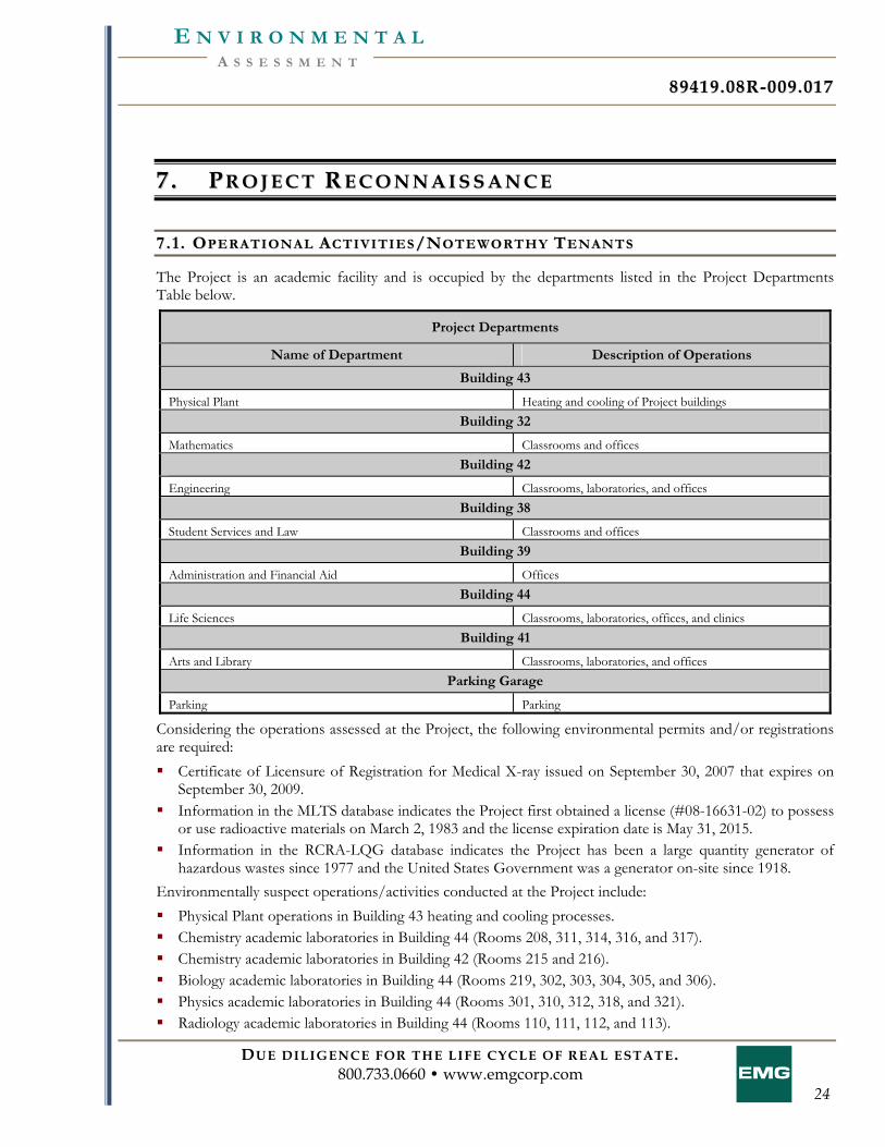
8899441199 .. 0088RR-- 000099 .. 001177
DUE DILIGENCE FOR THE LIFE CYCLE OF REAL ESTATE. 800.733.0660 • www.emgcorp.com
24
A S S E S S M E N T E N V I R O N M E N T A L
77 .. PP RR OO JJ EE CC TT RR EE CC OO NN NN AA II SS SS AA NN CC EE
77 .. 11 .. OO PP EE RR AA TT II OO NN AA LL AA CC TT II VV II TT II EE SS //NN OO TT EE WW OO RR TT HH YY TT EE NN AA NN TT SS
The Project is an academic facility and is occupied by the departments listed in the Project Departments Table below.
Project Departments
Name of Department Description of Operations
Building 43
Physical Plant Heating and cooling of Project buildings Building 32
Mathematics Classrooms and offices Building 42
Engineering Classrooms, laboratories, and offices Building 38
Student Services and Law Classrooms and offices Building 39
Administration and Financial Aid Offices Building 44
Life Sciences Classrooms, laboratories, offices, and clinics Building 41
Arts and Library Classrooms, laboratories, and offices Parking Garage
Parking Parking
Considering the operations assessed at the Project, the following environmental permits and/or registrations are required: Certificate of Licensure of Registration for Medical X-ray issued on September 30, 2007 that expires on
September 30, 2009. Information in the MLTS database indicates the Project first obtained a license (#08-16631-02) to possess
or use radioactive materials on March 2, 1983 and the license expiration date is May 31, 2015. Information in the RCRA-LQG database indicates the Project has been a large quantity generator of
hazardous wastes since 1977 and the United States Government was a generator on-site since 1918. Environmentally suspect operations/activities conducted at the Project include: Physical Plant operations in Building 43 heating and cooling processes. Chemistry academic laboratories in Building 44 (Rooms 208, 311, 314, 316, and 317). Chemistry academic laboratories in Building 42 (Rooms 215 and 216). Biology academic laboratories in Building 44 (Rooms 219, 302, 303, 304, 305, and 306). Physics academic laboratories in Building 44 (Rooms 301, 310, 312, 318, and 321). Radiology academic laboratories in Building 44 (Rooms 110, 111, 112, and 113).
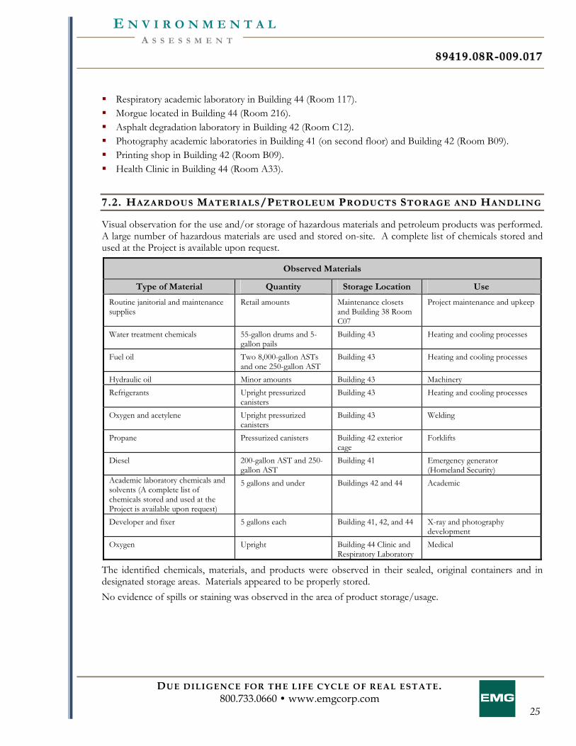
8899441199 .. 0088RR-- 000099 .. 001177
DUE DILIGENCE FOR THE LIFE CYCLE OF REAL ESTATE. 800.733.0660 • www.emgcorp.com
25
A S S E S S M E N T E N V I R O N M E N T A L
Respiratory academic laboratory in Building 44 (Room 117). Morgue located in Building 44 (Room 216). Asphalt degradation laboratory in Building 42 (Room C12). Photography academic laboratories in Building 41 (on second floor) and Building 42 (Room B09). Printing shop in Building 42 (Room B09). Health Clinic in Building 44 (Room A33).
77 .. 22 .. HH AA ZZ AA RR DD OO UU SS MM AA TT EE RR II AA LL SS //PP EE TT RR OO LL EE UU MM PP RR OO DD UU CC TT SS SS TT OO RR AA GG EE AA NN DD HH AA NN DD LL II NN GG
Visual observation for the use and/or storage of hazardous materials and petroleum products was performed. A large number of hazardous materials are used and stored on-site. A complete list of chemicals stored and used at the Project is available upon request.
Observed Materials
Type of Material Quantity Storage Location Use
Routine janitorial and maintenance supplies
Retail amounts Maintenance closets and Building 38 Room C07
Project maintenance and upkeep
Water treatment chemicals 55-gallon drums and 5-gallon pails
Building 43 Heating and cooling processes
Fuel oil Two 8,000-gallon ASTs and one 250-gallon AST
Building 43 Heating and cooling processes
Hydraulic oil Minor amounts Building 43 Machinery Refrigerants Upright pressurized
canisters Building 43 Heating and cooling processes
Oxygen and acetylene Upright pressurized canisters
Building 43 Welding
Propane Pressurized canisters Building 42 exterior cage
Forklifts
Diesel 200-gallon AST and 250-gallon AST
Building 41 Emergency generator (Homeland Security)
Academic laboratory chemicals and solvents (A complete list of chemicals stored and used at the Project is available upon request)
5 gallons and under Buildings 42 and 44 Academic
Developer and fixer 5 gallons each Building 41, 42, and 44 X-ray and photography development
Oxygen Upright Building 44 Clinic and Respiratory Laboratory
Medical
The identified chemicals, materials, and products were observed in their sealed, original containers and in designated storage areas. Materials appeared to be properly stored. No evidence of spills or staining was observed in the area of product storage/usage.
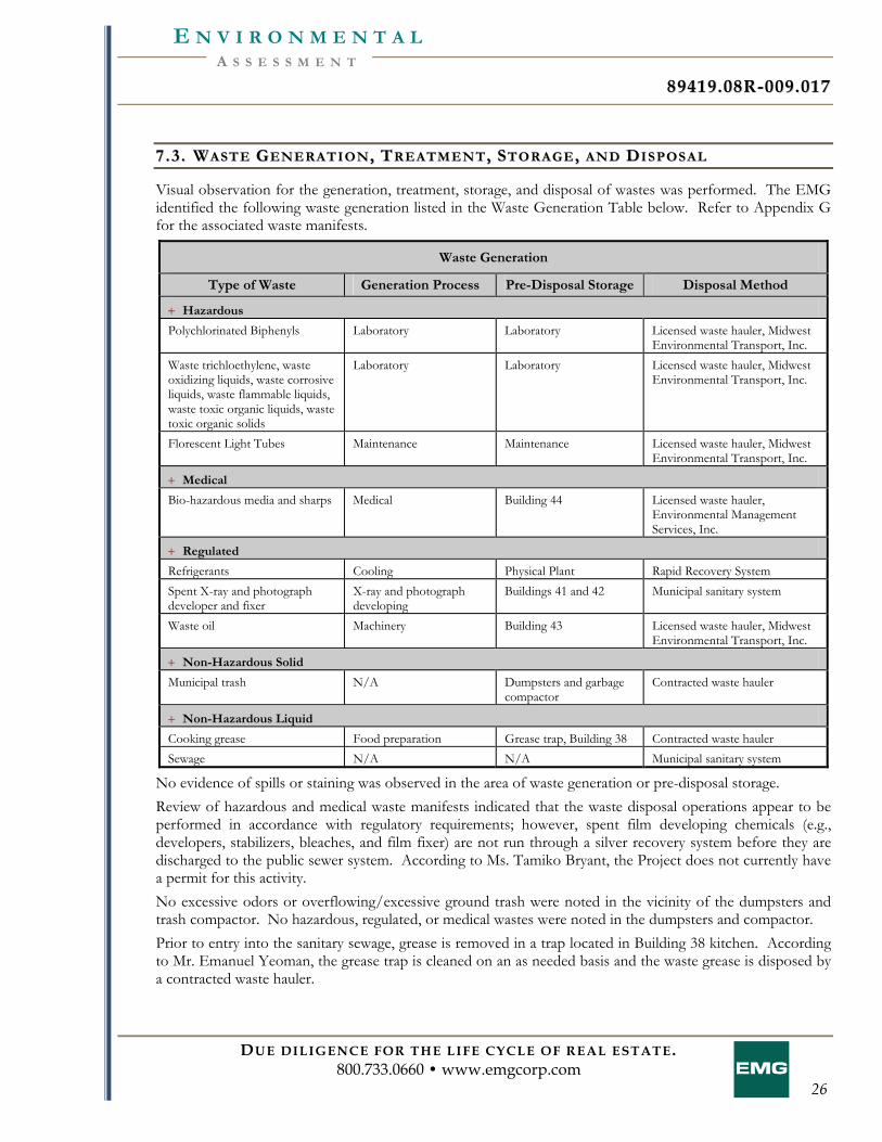
8899441199 .. 0088RR-- 000099 .. 001177
DUE DILIGENCE FOR THE LIFE CYCLE OF REAL ESTATE. 800.733.0660 • www.emgcorp.com
26
A S S E S S M E N T E N V I R O N M E N T A L
77 .. 33 .. WW AA SS TT EE GG EE NN EE RR AA TT II OO NN ,, TT RR EE AA TT MM EE NN TT ,, SS TT OO RR AA GG EE ,, AA NN DD DD II SS PP OO SS AA LL
Visual observation for the generation, treatment, storage, and disposal of wastes was performed. The EMG identified the following waste generation listed in the Waste Generation Table below. Refer to Appendix G for the associated waste manifests.
Waste Generation
Type of Waste Generation Process Pre-Disposal Storage Disposal Method
+ Hazardous
Polychlorinated Biphenyls Laboratory Laboratory Licensed waste hauler, Midwest Environmental Transport, Inc.
Waste trichloethylene, waste oxidizing liquids, waste corrosive liquids, waste flammable liquids, waste toxic organic liquids, waste toxic organic solids
Laboratory Laboratory Licensed waste hauler, Midwest Environmental Transport, Inc.
Florescent Light Tubes Maintenance Maintenance Licensed waste hauler, Midwest Environmental Transport, Inc.
+ Medical
Bio-hazardous media and sharps Medical Building 44 Licensed waste hauler, Environmental Management Services, Inc.
+ Regulated
Refrigerants Cooling Physical Plant Rapid Recovery System Spent X-ray and photograph developer and fixer
X-ray and photograph developing
Buildings 41 and 42 Municipal sanitary system
Waste oil Machinery Building 43 Licensed waste hauler, Midwest Environmental Transport, Inc.
+ Non-Hazardous Solid
Municipal trash N/A Dumpsters and garbage compactor
Contracted waste hauler
+ Non-Hazardous Liquid
Cooking grease Food preparation Grease trap, Building 38 Contracted waste hauler Sewage N/A N/A Municipal sanitary system
No evidence of spills or staining was observed in the area of waste generation or pre-disposal storage. Review of hazardous and medical waste manifests indicated that the waste disposal operations appear to be performed in accordance with regulatory requirements; however, spent film developing chemicals (e.g., developers, stabilizers, bleaches, and film fixer) are not run through a silver recovery system before they are discharged to the public sewer system. According to Ms. Tamiko Bryant, the Project does not currently have a permit for this activity. No excessive odors or overflowing/excessive ground trash were noted in the vicinity of the dumpsters and trash compactor. No hazardous, regulated, or medical wastes were noted in the dumpsters and compactor. Prior to entry into the sanitary sewage, grease is removed in a trap located in Building 38 kitchen. According to Mr. Emanuel Yeoman, the grease trap is cleaned on an as needed basis and the waste grease is disposed by a contracted waste hauler.
8899441199 .. 0088RR-- 000099 .. 001177
DUE DILIGENCE FOR THE LIFE CYCLE OF REAL ESTATE. 800.733.0660 • www.emgcorp.com
27
A S S E S S M E N T E N V I R O N M E N T A L
77 .. 44 .. PP OO LL YY CC HH LL OO RR II NN AA TT EE DD BB II PP HH EE NN YY LL SS (( PPCCBB SS ))
The Project is supplied with underground secondary electrical service from pad-mounted electrical transformers with secondary containment in electrical vaults. The transformers are designated as the property of PEPCO, the public utility. The units are not classified regarding PCB content. The units should be periodically inspected for leakage. If leakage is visible, the Project owner/manager should contact the public utility, which will remediate the situation. Should the units have to be replaced, the utility is responsible, provided the cause is equipment failure, not customer misuse. No leakage of the transformers was observed at the time of the assessment. The Project also uses secondary electrical service from privately owned “dry type” step-down transformers. Dry type transformers do not use oils for cooling purposes; therefore, these transformers are not expected to contain PCBs. The Project maintains one hydraulic elevator, which is located in Building 38. Because the unit was installed prior to 1978 (the USEPA banned the manufacturing of PCB-containing hydraulic fluid in 1976, and the manufacture of PCBs ceased in 1977), EMG is of the opinion that the elevator hydraulic fluid potentially contains PCBs. No visual indication of leakage was observed in the area of the elevator operating equipment. The hydraulic elevator unit at the Project should be periodically inspected for leakage. If leakage is identified, the unit should be repaired and any fluid or fluid-soaked waste disposed of in accordance with applicable federal, state, and local regulations. A hydraulic trash compactor is located at the Project. PCB-containing hydraulic fluid has not been manufactured since 1977. Therefore, based on the date of installation (post 1977), PCB-containing hydraulic fluid is not likely to be found in the operating system. No visual indication of leakage was observed in the area of the equipment. No additional equipment with the potential to utilize dielectric or hydraulic fluid was observed during the site assessment.
77 .. 55 .. AA SS BB EE SS TT OO SS -- CC OO NN TT AA II NN II NN GG MM AA TT EE RR II AA LL SS (( AACCMM))
Suspect ACM in the form of resilient floor tiles/mastic, sheet flooring, ceiling tiles, drywall/joint compound, spray applied fireproofing, pipe wrap, insulation, and roofing materials were visually identified during the on-site assessment. No samples were collected based on the Scope of Work. No ACM documentation was provided during the site assessment, with the exception of the October 20, 2006 Limited Hazardous Building Materials Survey Report completed by MACTEC Engineering and Consulting, Inc. (MACTEC) for a portion of Building 43. The purpose of the MACTEC report was to identify ACM and lead-containing surface coatings in boiler components and associated piping that would be impacted during the boiler replacement. Skim coat mud on fiberglass pipe insulation, boiler stack exhaust insulation, boiler door insulation, interior boiler fire brick, and debris were sampled during the inspection. The laboratory analysis indicated that the skim coat mud on the fiberglass pipe insulation associated with the medium pressure steam and feed pipes contained 2-3% Chrysotile asbestos. Results for the other suspect materials sampled by MACTEC were “none detected”. MACTEC recommended that the ACM mud on fiberglass pipe insulation associated with the boiler piping be removed by a qualified asbestos abatement contractor licensed in the District of Columbia prior to being impacted by renovation activities.
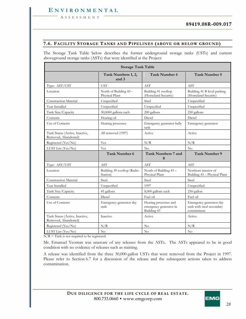
8899441199 .. 0088RR-- 000099 .. 001177
DUE DILIGENCE FOR THE LIFE CYCLE OF REAL ESTATE. 800.733.0660 • www.emgcorp.com
28
A S S E S S M E N T E N V I R O N M E N T A L
77 .. 66 .. FF AA CC II LL II TT YY SS TT OO RR AA GG EE TT AA NN KK SS AA NN DD PP II PP EE LL II NN EE SS (( AA BB OO VV EE OO RR BB EE LL OO WW GG RR OO UU NN DD ))
The Storage Tank Table below describes the former underground storage tanks (USTs) and current aboveground storage tanks (ASTs) that were identified at the Project:
Storage Tank Table
Tank Numbers 1, 2, and 3
Tank Number 4 Tank Number 5
Type: AST/UST UST AST AST Location North of Building 43 –
Physical Plant Building 41 rooftop (Homeland Security)
Building 41 B level parking (Homeland Security)
Construction Material Unspecified Steel Unspecified Year Installed Unspecified Unspecified Unspecified Tank Size/Capacity 30,0000 gallons each 200 gallons 250 gallons Contents Heating oil Diesel Diesel Use of Contents Heating processes Emergency generator belly
tank Emergency generator
Tank Status (Active, Inactive, Removed, Abandoned)
All removed (1997) Active Active
Registered (Yes/No) Yes N/R N/R LUST List (Yes/No) Yes No No
Tank Number 6 Tank Numbers 7 and 8
Tank Number 9
Type: AST/UST AST AST AST Location Building 39 rooftop (Radio
Station) North of Building 43 – Physical Plant
Northern interior of Building 43 – Physical Plant
Construction Material Steel Steel Steel Year Installed Unspecified 1997 Unspecified Tank Size/Capacity 45 gallons 8,000 gallons each 250-gallon Contents Diesel Fuel oil Fuel oil Use of Contents Emergency generator day
tank Heating processes and emergency generator in Building 43
Emergency generator day tank with steel secondary containment
Tank Status (Active, Inactive, Removed, Abandoned)
Inactive Active Active
Registered (Yes/No) N/R No N/R LUST List (Yes/No) No No No
N/R = Tank is not required to be registered.
Mr. Emanuel Yeoman was unaware of any releases from the ASTs. The ASTs appeared to be in good condition with no evidence of releases such as staining. A release was identified from the three 30,000-gallon USTs that were removed from the Project in 1997. Please refer to Section 6.7 for a discussion of the release and the subsequent actions taken to address contamination.
8899441199 .. 0088RR-- 000099 .. 001177
DUE DILIGENCE FOR THE LIFE CYCLE OF REAL ESTATE. 800.733.0660 • www.emgcorp.com
29
A S S E S S M E N T E N V I R O N M E N T A L
In addition, visual observations identified eight ground water monitoring wells and two metal covers which appear to be associated with the monitoring wells, all of which are located north of Building 43 in the general location of the former USTs, as well as to the northeast of the Project. The wells are flush mounted with a cover bolted to the outer casing. According to the Response Action Plan (discussed in Section 6.7), the ground water monitoring wells were installed in and after 1997 to investigate the reported release associated with the former on-site USTs. The prior report noted that the measured ground water levels were approximately 15 feet below ground surface. In addition, the ground water flow direction was reported to be toward the north-northeast. The additional manways and surface caps observed at the Project were for site services (i.e., domestic water, storm water, and sanitary sewer system). Based on the review of the state list of registered USTs, no current USTs are registered for the Project. Interviews with persons knowledgeable of the Project did not identify any evidence of additional current or historic storage tanks (above or below ground) at the Project. Visual observations did not identify any surface markings indicating the existence of subsurface product pipelines at the Project.
77 .. 77 .. SS UU RR FF AA CC EE AA RR EE AA SS
The land surface of the Project slopes steeply to the northeast. Surface water flow is in a northeasterly direction. Visual observation of the Project and adjacent properties did not identify any evidence of distressed vegetation, staining, or surface migration of petroleum releases or hazardous materials onto or off the Project. Visual observations did not identify any evidence of on-site surface impoundment facilities, pits, dry wells, or dumping of apparent hazardous substances at the Project. Visual observations did not identify any surface water features including lagoons, ponds or other bodies of water at the Project. The Project utilizes an underground parking garage. According to Mr. Emanuel Yeoman, road water, oil and dirt flow to storm water sewer drains on the lower level of the parking garage. Storm water from the roof areas is directed to the municipal sewer via internal drains. Storm water from vegetated surface areas naturally infiltrates into the subsurface.
77 .. 88 .. MM OO LL DD
EMG performed a limited visual assessment for the presence of mold, conditions conducive to mold, and evidence of moisture in readily accessible interior areas of the Project. Suspect mold growth and water damage was observed in the following areas: Approximately two square feet of water damaged painted drywall ceiling and ten square feet of water
damaged painted concrete masonry walls in the break room of the Building 43 C level. Mr. Emanuel Yeoman was unaware of the cause of the water damage.
According to Mr. Emanuel Yeoman, the drinking water fountain pipe recently burst on the second level of Buildings 32 and 42, which are connected, flooding the floor. He is in the process or repairing the water damage and addressing the pipe issue.
According to Mr. Emanuel Yeoman, there is a window leak that floods Room 114B of Building 42 when there is a heavy rain.
8899441199 .. 0088RR-- 000099 .. 001177
DUE DILIGENCE FOR THE LIFE CYCLE OF REAL ESTATE. 800.733.0660 • www.emgcorp.com
30
A S S E S S M E N T E N V I R O N M E N T A L
Approximately 16 square feet of ceiling tile was removed from the women’s room on Level C of Building 32 due to water damage from a burst pipe on the B level in December of 2008.
Water staining on the concrete in the stairwells of Building 38 and Building 39 was reportedly caused by leaking sky lights. According to Mr. Emanuel Yeoman, these leaks have been repaired.
Approximately 15 square feet of water stained ceilling tile was observed in the women’s room on the first floor of Building 38. Approximately 20 square feet of water damaged ceiling tile was observed in Room 108 and the first level hallways of Building 38. Approixmately five square feet of water damaged ceiling tile was observed in A10 and A14 of Building 38. Approximatley 10 square feet of water damaged ceiling tile was observed on the first floor of Building 39. According to Mr. Emanuel Yeoman, the damage was caused from a former leak on the second floor from an open valve that flooded the buildings.
According to Mr. Emanuel Yeoman, there is a window leak that floods Room 103 of Building 38 when there is a heavy rain.
Approximately 50 square feet of water damaged painted drywall ceilng in the copy room on level C of Building 39. According to Mr. Emanuel Yeoman, this damage was caused by the leaking expansion joint above the area.
Approximately two square feet of suspect mold was observed on the drywall in Room CC05 of Building 39. According to Mr. Emanuel Yeoman, this damage was caused by a pipe leak.
Approximately 12 square feet of suspect mold and water damged drywall and ceiling tile was observed in Room 311 of Building 44, as well as 20 square feet of water damaged floor tiles in the nearby hallway. According to Mr. Emanuel Yeoman, this damage was caused by a roof leak and the roof has since been repaired.
Approximately eight square feet of water damged ceiling tiles were removed from the elevator waiting area of Building 44 and the morgue on the second floor. According to Mr. Emanuel Yeoman, the damage was caused from a leaking chiller.
Significant water damaged ceiling tiles, dry wall, and carpeting was observed on the fifth, fourth, third, second, and first floors of Building 41. According to Mr. Emanuel Yeoman, the damage was caused by a leaking condensation pan and an overflow from a janitorial sink that flooded the building.
Approximately 10 square feet of suspect mold on painted drywall ceiling in the electrical closet of the parking garage B level. Mr. Emanuel Yeoman was unaware of the cause of the damage.
Approximately 10 square feet of suspect mold on painted drywall ceiling in the electrical closet of the parking garage B level. Mr. Emanuel Yeoman was unaware of the cause of the damage.
Significant water damage to concrete was noted throughout the parking garage. This assessment does not constitute a comprehensive mold survey of the Project. The reported observations and conclusions are based solely on interviews with Project personnel and conditions as observed in readily accessible interior areas of the Project on the assessment date.
8899441199 .. 0088RR-- 000099 .. 001177
DUE DILIGENCE FOR THE LIFE CYCLE OF REAL ESTATE. 800.733.0660 • www.emgcorp.com
31
A S S E S S M E N T E N V I R O N M E N T A L
88 .. II NN TT EE RR VV II EE WW SS
88 .. 11 .. KK EE YY SS II TT EE MM AA NN AA GG EE RR
EMG met with Mr. David Watts, Key Site Manager, On-site Point of Contact (POC), and General Counsel. Mr. Watts was interviewed by EMG during the site visit and provided information regarding the history of the Project and operations at the Project. A Pre-Survey Questionnaire was completed as a part of this assessment which is included in the Appendices (Section 11). The Questionnaire was completed by the Key Site Manager. Information obtained from the Questionnaire has been used in the preparation of this report. Mr. Watts indicated that he was not aware of any pending, threatened, or past litigation or administrative proceedings relevant to hazardous substances or petroleum products, or notices from any governmental entity regarding possible violation of environmental laws or possible liability related to hazardous substances or petroleum products.
88 .. 22 .. OO WW NN EE RR
EMG submitted an Owner Questionnaire to the user in an effort to identify the owner of the Project that could be interviewed to provide information regarding proceedings involving the Project. A completed Owner Questionnaire was not returned to EMG. The lack of or inability to obtain this information represents a data gap. However, based on the findings of this report, the absence of this information is not considered a significant data gap.
88 .. 33 .. UU SS EE RR
EMG submitted a User Questionnaire to the user in an effort to identify the owner of the Project that could be interviewed to provide information regarding proceedings involving the Project. A completed User Questionnaire was not returned to EMG. The lack of or inability to obtain this information represents a data gap. However, based on the findings of this report, the absence of this information is not considered a significant data gap.
88 .. 44 .. OO CC CC UU PP AA NN TT SS
EMG interviewed Ms. Tamiko Bryant, Director of Environmental Health and Safety, who was cooperative and provided information which appeared to be accurate based upon our subsequent site observations. It is EMG’s opinion that Ms. Bryant was somewhat knowledgeable about the Project, and the questions EMG posed during the interview process. According to Ms. Bryant, the Project was developed in the 1970s into the current use. Ms. Bryant stated that prior to the current use the Project was used as a government facility. Ms. Bryant indicated that she has been associated with the Project for four years.
8899441199 .. 0088RR-- 000099 .. 001177
DUE DILIGENCE FOR THE LIFE CYCLE OF REAL ESTATE. 800.733.0660 • www.emgcorp.com
32
A S S E S S M E N T E N V I R O N M E N T A L
EMG interviewed Mr. Emanuel Yeoman, Maintenance Specialist, who was cooperative and provided information which appeared to be accurate based upon our subsequent site observations. It is EMG’s opinion that Mr. Yeoman was somewhat knowledgeable about the Project, and the questions EMG posed during the interview process. According to Mr. Yeoman, the Project was developed in the 1970s into the current use. Mr. Yeoman stated that prior to the current use the Project was used as the National Bureau of Standards. Mr. Yeoman indicated that he has been associated with the Project for the past twenty-two years.
88 .. 55 .. PP AA SS TT OO WW NN EE RR SS ,, OO PP EE RR AA TT OO RR SS ,, AA NN DD OO CC CC UU PP AA NN TT SS
No past owners, operators, or occupants of the Project who would likely have material information regarding the potential for contamination at the Project were identified.
88 .. 66 .. OO WW NN EE RR SS OO RR OO CC CC UU PP AA NN TT SS OO FF AA DD JJ AA CC EE NN TT OO RR NN EE AA RR BB YY PP RR OO PP EE RR TT YY
The Project was not an abandoned property with evidence of unauthorized uses or uncontrolled access; therefore, interviews were not conducted with adjacent or nearby property owners or occupants.
88 .. 77 .. II NN TT EE RR VV II EE WW SS WW II TT HH OO TT HH EE RR SS
No other individuals were interviewed as part of this assessment.
8899441199 .. 0088RR-- 000099 .. 001177
DUE DILIGENCE FOR THE LIFE CYCLE OF REAL ESTATE. 800.733.0660 • www.emgcorp.com
33
A S S E S S M E N T E N V I R O N M E N T A L
99 .. RR EE GG UU LL AA TT OO RR YY DD AA TT AA BB AA SS EE RR EE VV II EE WW
Based on review of the regulatory database report, and by cross-referencing name, address, and zip code, EMG concludes that the Project is listed on the regulatory database. Furthermore, the area search of the Project for sites listed in these databases identified various sites outlined in the regulatory database report included in the Appendices, Section 11. Information about the listed sites is included below. EMG also reviewed the unmappable sites in the database report, cross-referencing addresses and site names. Unmappable sites are environmental risk sites that cannot be plotted with confidence, but can be located by zip code or city name. In general, a site cannot be geocoded because of inaccurate or missing location information in the record provided by the agency. Any identified unmappable site within the specified search radii is included below. The following are some of the databases which were reviewed for this assessment. See the appended regulatory database report for a complete listing of databases reviewed for this assessment: NPL Listing: The National Priorities (Superfund) List (NPL) is United States Environmental Protection
Agency (USEPA’s) database of uncontrolled or abandoned hazardous waste sites identified for priority remedial actions under the Superfund Program.
Delisted NPL Listing: The Delisted NPL database is a listing of sites which have been deleted from the NPL list by the USEPA.
RCRA-TSD Facilities Listing: The USEPA’s Resource Conservation and Recovery Act (RCRA) Program identifies and tracks hazardous waste from the point of generation to the point of disposal. The RCRA-TSD database is a compilation by the USEPA of reporting facilities that transport, treat, store or dispose of hazardous waste.
RCRA-Corracts Facilities Listing: The USEPA’s Resource Conservation and Recovery Act (RCRA) Corrective Action-sites Listing contains information pertaining to hazardous waste treatment, storage, and disposal facilities (RCRA TSD) which have conducted, or are currently conducting, a corrective action(s) as regulated under RCRA.
CERCLIS Listing: This database is a compilation of sites which the USEPA has investigated or is currently investigating for a release or threatened release of hazardous substances.
NFRAP Listing: This database contains information regarding sites which have been removed from the USEPA CERCLIS database.
RCRIS-Generator Listing: The USEPA identifies and tracks hazardous waste from the point of generation to the point of disposal through the Resource Conservation and Recovery Information System (RCRIS). The RCRIS-Generators database is a compilation by the USEPA of facilities that report hazardous waste generation.
Emergency Response Notification System (ERNS): The ERNS is a national database used to collect information on reported releases of oil or hazardous substances.
Integrated Compliance Information System (ICIS): The ICIS supports the information needs of the national enforcement and compliance program as well as the unique needs of the NPDES program.
Material Licensing Tracking System (MLTS): MLTS is maintained by the Nuclear Regulatory Commission and contains a list of sites which possess or use radioactive materials and which are subject to NRC licensing requirements.
Formerly Used Defense Sites (FUDS): FUDS are properties where the Unites States Army Corps of Engineers is actively working or will take necessary cleanup actions.
8899441199 .. 0088RR-- 000099 .. 001177
DUE DILIGENCE FOR THE LIFE CYCLE OF REAL ESTATE. 800.733.0660 • www.emgcorp.com
34
A S S E S S M E N T E N V I R O N M E N T A L
Federal institutional control registry: This database contains information on-sites with federal institutional controls.
Federal engineering control registry: This database contains information on-sites with federal engineering controls.
SHWS Listing: The District of Columbia does not maintain a SHWS database; therefore, the search distance for the CERCLIS database was extended to cover the appropriate distance that the SHWS database would have been searched.
SWF Listing: This database is a comprehensive listing of all State Permitted Solid Waste Landfills. Leaking Underground Storage Tanks: This database contains a summary of information pertaining to
leaking underground storage tank (LUST) sites identified by the state. Underground Storage Tanks: This database contains a summary of information pertaining to
registered underground storage tanks (USTs) identified by the state. State Brownfield sites: This database contains information on brownfield sites as maintained by the State. State Voluntary Cleanup Sites: This database contains a listing of sites which are in the State voluntary
cleanup program Tribal Voluntary Cleanup Sites: This database contains a listing of sites which are in the Tribal voluntary
cleanup program Tribal ODI Listing: This database contains information on Tribal ODI sites. Tribal LUST: This database contains information on Tribal LUST sites. Tribal UST: This database contains information on Tribal UST sites.
The following is a discussion of listed sites: UUNNIIVVEERRSSIITTYY OOFF TTHHEE DDIISSTTRRIICCTT OOFF CCOOLLUUMMBBIIAA 4200 Connecticut Avenue, Northwest Distance: N/A (The Project) Direction: N/A (The Project) Databases listed on: FINDS, ICIS, MLTS, LUST, UST, CERC-NFRAP, RCRA-LQG, and Manifest
8899441199 .. 0088RR-- 000099 .. 001177
DUE DILIGENCE FOR THE LIFE CYCLE OF REAL ESTATE. 800.733.0660 • www.emgcorp.com
35
A S S E S S M E N T E N V I R O N M E N T A L
The above site is the Project. Information in the FINDS database indicates the Project (also listed as Van Ness Power Plant Campus) is listed on the Aerometric Information Retrieval System Facility Subsystem (AFS) database, the RCRA Info information system, and the Integrated Compliance Information System (ICIS). Information in the ICIS database indicates the Project (also listed as The Teachers College) was on the national enforcement and compliance program for Enforcement Action ID #’s 03-2000-0535, 03-1997-0148, and 03-1997-0133. Information in the ICIS database indicates the Van Ness Power Plant Campus is listed for Enforcement Action ID # 03-1997-0232. The ICIS listings appear to be associated with the AFS and RCRA Info listings; however, no details pertaining to the ICIS, AFS, or RCRA Info listings was available in the regulatory database report. Information in the MLTS database indicates the Project first obtained a license (#08-16631-02) to possess or use radioactive materials on March 2, 1983 and the license expiration date is May 31, 2015. Information in the LUST database indicates that the Project (listed as DC Public Schools, Facility ID# 3-001818) is listed with an open case status for a release reported on January 18, 1997 (Case # 97034). Information in the UST database indicates the Project had three 30,000-gallon heating oil USTs that are listed as permanently out of use. Information in the CERC-NFRAP database describes an incident at the Project as “UDC Oil Spill” under Site ID # 0305283. The CERC-NFRAP database describes the Project as being located in a highly commercial and residential area of the northwest section of Washington and that Soapstone Creek is approximately 500 feet from the University in an easterly direction. Reportedly, a release was discovered on January 18, 1997, and a finding of “no further remedial action” was given on October 14, 1999. The case for the Project was archived on August 24, 2000. More information regarding the former on-site USTs and the circumstances being the LUST and CERC-NFRAP cases is included in Sections 6.7 and 7.6. Information in the RCRA-LQG and Manifest databases indicates the Project has been a large quantity generator of hazardous wastes since 1977 and the United States Government was a generator on-site since 1918. The Project was identified with multiple violations, all of which were brought in to regulatory compliance. More information regarding the hazardous wastes generated at the Project is included in Section 7.3. EMG recommends groundwater quality sampling and laboratory analysis be continued at the Project in accordance with all applicable regulations and requirements in order to achieve regulatory closure. MMCCDDOOWWEELLLL BBRROOTTHHEERRSS,, IINNCC.. 4201 Connecticut Avenue, Northwest Distance: Adjacent (corrected) Direction: East Databases listed on: UST
Based on review of the USGS Topographic Map, this site is located topographically downgradient from the Project and estimated groundwater flow in the area of the site is to the northeast, away from the Project. Information in the EDR Historical Auto Stations database indicates the site was a gasoline station and service station in 1940, 1943, 1948, and 1954. Information in the UST database indicates the site had five 1,000-gallon gasoline USTs that are permanently out of use. The UST database is a listing of facilities that are required to register their USTs for tracking purposes and are not necessarily sites with reported contamination incidents. This site is not listed in any database that reports leaks or spills, like the LUST database. Based on topographic relations and estimated groundwater flow, this site is not anticipated to have adversely impacted the environmental integrity of the Project.

8899441199 .. 0088RR-- 000099 .. 001177
DUE DILIGENCE FOR THE LIFE CYCLE OF REAL ESTATE. 800.733.0660 • www.emgcorp.com
36
A S S E S S M E N T E N V I R O N M E N T A L
VVAANN NNEESSSS TTEEXXAACCOO//JJEENNSSOONN TTEEXXAACCOO SSEERRVVIICCEE 4225 Connecticut Avenue, Northwest Distance: Adjacent (corrected) Direction: East Databases listed on: FINDS, UST, RCRA-CESQG, Manifest, and LUST
Based on review of the USGS Topographic Map, this site is located topographically downgradient from the Project and estimated groundwater flow in the area of the site is to the northeast, away from the Project. Information in the FINDS, RCRA-CESQG, and Manifest databases indicates the site is a conditionally exempt small quantity generator of hazardous wastes with violations listed that have achieved regulatory compliance. Information in the UST database indicates four 10,000-gallon gasoline USTs, one 4,000-gallon gasoline UST, and one 550-gallon used oil UST are currently in use. Information in the EDR Historical Auto Stations database indicates the site was a gasoline and service station in 1943, 1948, and 1954. Information in the LUST database indicates the site (Facility ID # 3-000685) had a reported release (Case # 89013) that has been granted a closed status. The regulatory agency awards a case-closed status when contamination, if any, has been investigated and/or remediated in accordance with currently accepted regulatory standards. Based on topographic relations, estimated groundwater flow, and current regulatory status, this site is not anticipated to have adversely impacted the environmental integrity of the Project. EEMMBBAASSSSYY CCLLEEAANNEERRSS 4215 Connecticut Avenue, Northwest Distance: Adjacent (corrected) Direction: East Databases listed on: FINDS and RCRA-CESQG
Based on review of the USGS Topographic Map, this site is located topographically downgradient from the Project and estimated groundwater flow in the area of the site is to the northeast, away from the Project. Information in the FINDS and RCRA-CESQG databases indicates that the site is a conditionally exempt small quantity generator of hazardous wastes with violations listed that have achieved compliance. The RCRIS-Generator database is a listing of facilities that, due to the amount of hazardous waste generated, are required to register with the USEPA for tracking purposes and are not necessarily sites with reported contamination incidents. Based on topographic relations and estimated groundwater flow, this site is not anticipated to have adversely impacted the environmental integrity of the Project. VVAANN NNEESSSS CCEENNTTEERR LLTTDD PPAARRTTNNEERRSSHHIIPP 4301 Connecticut Avenue, Northwest Distance: Adjacent (corrected) Direction: East Database listed on: UST
Based on review of the USGS Topographic Map, this site is located topographically downgradient from the Project and estimated groundwater flow in the area of the site is to the northeast, away from the Project. Information in the UST database indicates the site has a 20,000-gallon heating oil UST that is currently in use and a 5,000-gallon heating oil UST that is permanently out of use. The UST database is a listing of facilities that are required to register their USTs for tracking purposes and are not necessarily sites with reported contamination incidents. In addition, this site is not listed in any database that reports leaks or spills, such as the LUST, NPL, SHWS, or CERCLIS Listings. Based on topographic relations and estimated groundwater flow, this site is not anticipated to have adversely impacted the environmental integrity of the Project.
8899441199 .. 0088RR-- 000099 .. 001177
DUE DILIGENCE FOR THE LIFE CYCLE OF REAL ESTATE. 800.733.0660 • www.emgcorp.com
37
A S S E S S M E N T E N V I R O N M E N T A L
IINNTTEELLSSAATT 3400 International Drive, Northwest Distance: Adjacent (corrected) Direction: South Databases listed on: UST, Manifest, and RCRA-CESQG
Based on review of the USGS Topographic Map, this site is located topographically upgradient from the Project and estimated groundwater flow in the area of the site is to the northeast, towards the Project. Information in the UST database indicates the site has three 20,000-gallon diesel USTs currently in use and one 3,000-gallon diesel UST which is listed as permanently out of use. The UST database is a listing of facilities that are required to register their USTs for tracking purposes and are not necessarily sites with reported contamination incidents. Information in the Manifest and RCRA-CESQG databases indicates the site is a conditionally exempt small quantity generator of hazardous wastes with violations that have achieved compliance. The RCRIS-Generator database is a listing of facilities that, due to the amount of hazardous waste generated, are required to register with the USEPA for tracking purposes and are not necessarily sites with reported contamination incidents. Furthermore, this site was not identified on the any database which reports releases or spills such as the LUST, NPL, SHWS, or CERCLIS Listings. Based on the current regulatory status, this site is not anticipated to have adversely impacted the environmental integrity of the Project. DDIIAAMMOONNDD OORRDDNNAANNCCEE FFUUZZEE LLAABB Connecticut Avenue and Windom Place Distance: Adjacent (corrected) Direction: Northeast Databases listed on: CERCLIS and FUDS
Based on review of the USGS Topographic Map, this site is located topographically downgradient from the Project and estimated groundwater flow in the area of the site is to the northeast, away from the Project. Information in the CERCLIS database indicates the site had a reported release on January 11, 2001 and was put on high priority for further assessment on November 2, 2001. Information in the FUDS database indicates the site has Federal Facility ID # DC9799F9283. Based on topographic relations and estimated groundwater flow, this site is not anticipated to have adversely impacted the environmental integrity of the Project. PPAARRKKLLAANNEE CCLLEEAANNEERRSS 4304 Connecticut Avenue, Northwest Distance: Approximately 50 Feet (corrected) Direction: Northeast (corrected) Database listed on: RCRA-CESQG
Based on review of the USGS Topographic Map, this site is located topographically downgradient from the Project and estimated groundwater flow in the area of the site is to the northeast, away from the Project. Information in the RCRA-CESQG database indicates the site is a conditionally exempt small quantity generator of hazardous wastes with violations that have achieved compliance. The RCRIS-Generator database is a listing of facilities that, due to the amount of hazardous waste generated, are required to register with the USEPA for tracking purposes and are not necessarily sites with reported contamination incidents. Based on topographic relations and estimated groundwater flow, this site is not anticipated to have adversely impacted the environmental integrity of the Project.
8899441199 .. 0088RR-- 000099 .. 001177
DUE DILIGENCE FOR THE LIFE CYCLE OF REAL ESTATE. 800.733.0660 • www.emgcorp.com
38
A S S E S S M E N T E N V I R O N M E N T A L
UUSS DDEEPPTT SSTTAATTEE AANNNNEEXX 3333 3507 International Place Distance: Approximately 50 Feet (corrected) Direction: South Database listed on: RCRA-CESQG
Based on review of the USGS Topographic Map, this site is located topographically upgradient from the Project and estimated groundwater flow in the area of the site is to the northeast, towards the Project. Information in the RCRA-CESQG database indicates the site is a conditionally exempt small quantity generator of hazardous wastes with no violations listed. The RCRIS-Generator database is a listing of facilities that, due to the amount of hazardous waste generated, are required to register with the USEPA for tracking purposes and are not necessarily sites with reported contamination incidents. Based on current regulatory status, this site is not anticipated to have adversely impacted the environmental integrity of the Project. SSOOAAPPSSTTOONNEE CCRREEEEKK OOIILL SSPPIILLLL RREESSPPOONNSSEE//CCHHAARRLLEESS EE.. SSMMIITTHH RREESSIIDDEENNTTIIAALL RREEAALLIITTYY 4411 Connecticut Avenue, Northwest Distance: Approximately 250 Feet (corrected) Direction: Northeast Databases listed on: CERC-NFRAP and LUST
Based on review of the USGS Topographic Map, this site is located topographically downgradient from the Project and estimated groundwater flow in the area of the site is to the northeast, away from the Project. Information in the CERC-NFRAP database indicates a release was discovered on July 10, 1998 that received a status of “no further remedial action planned” on May 1, 2000, and was archived on May 2, 2002. Information in the LUST database indicates Case #98108 was reported on July 1, 1998, and received a “no further action status.” The regulatory agency awards a “no further action” status when contamination, if any, has been investigated and/or remediated in accordance with currently accepted regulatory standards. Based on topographic relations and estimated groundwater flow, this site is not anticipated to have adversely impacted the environmental integrity of the Project. EEMMBBAASSSSYY OOFF EEGGYYPPTT 3521 International Court, Northwest Distance: Approximately 315 Feet Direction: West Database listed on: UST
Based on review of the USGS Topographic Map, this site is located topographically cross-gradient from the Project and estimated groundwater flow in the area of the site is to the northeast, parallel to the Project. Information in the UST database indicates the site has a 1,000-gallon diesel UST currently in use. The UST database is a listing of facilities that are required to register their USTs for tracking purposes and are not necessarily sites with reported contamination incidents. This site was not identified on the any database which reports releases or spills such as the LUST, NPL, SHWS, or CERCLIS Listings. Based on estimated groundwater flow and current regulatory status, this site is not anticipated to have adversely impacted the environmental integrity of the Project.
8899441199 .. 0088RR-- 000099 .. 001177
DUE DILIGENCE FOR THE LIFE CYCLE OF REAL ESTATE. 800.733.0660 • www.emgcorp.com
39
A S S E S S M E N T E N V I R O N M E N T A L
VVAANN NNEESSSS AAPPAARRTTMMEENNTTSS SSOOUUTTHH 3003-05 Van Ness Street, Northwest Distance: Approximately 362 Feet Direction: East - Northeast Database listed on: UST
Based on review of the USGS Topographic Map, this site is located topographically downgradient from the Project and estimated groundwater flow in the area of the site is to the northeast, away from the Project. Information in the UST database indicate the site is listed with one 20,000-gallon heating oil UST that is permanently out of use and one 15,000-gallon heating oil UST that is currently in use. The UST database is a listing of facilities that are required to register their USTs for tracking purposes and are not necessarily sites with reported contamination incidents. This site was not identified on the any database which reports releases or spills such as the LUST, NPL, SHWS, or CERCLIS Listings. Based on topographic relations, estimated groundwater flow, and current regulatory status, this site is not anticipated to have adversely impacted the environmental integrity of the Project. SSIIRRIIUUSS,, LLLLCC 4107 Connecticut Avenue, Northwest Distance: Approximately 434 Feet Direction: South - Southeast Databases listed on: LUST and UST
Based on review of the USGS Topographic Map, this site is located topographically cross-gradient from the Project and estimated groundwater flow in the area of the site is to the northeast, away from the Project. Information in the LUST database indicates the site had a reported release on December 16, 1997 (Case # 98016) that has received a closed status. The regulatory agency awards a case-closed status when contamination, if any, has been investigated and/or remediated in accordance with currently accepted regulatory standards. Information in the UST database indicates that the site has one 2,000-gallon heating oil UST permanently out of use. Based on topographic relations and estimated groundwater flow, this site is not anticipated to have adversely impacted the environmental integrity of the Project. TTIILLDDEENN GGAARRDDEENN 3016, 3024, 3000, and 3900 Tilden Street, Northwest Distance: Approximately 846 Feet Direction: South Database listed on: LUST
Based on review of the USGS Topographic Map, this site is located topographically upgradient from the Project and estimated groundwater flow in the area of the site is to the northeast, towards the Project. Information in the LUST databases indicates the site had a release reported on October 30, 1998 (Case # 99011) that received a closed status, a release reported on October 25, 1996 (Case # 97006) that received a no further action status, a release reported on April 10, 2002 (Case # 2002041) that received a closed status, a release reported on November 12, 2002 (Case # 200305) that received a no further action status, and a release reported on October 25, 1996 (Case # 97007) that received a closed status. The regulatory agency awards a case-closed status when contamination, if any, has been investigated and/or remediated in accordance with currently accepted regulatory standards. Based on distance from the Project and current regulatory status, this site is not anticipated to have adversely impacted the environmental integrity of the Project. The additional cases listed in the regulatory database report are located greater than 900 feet from the Project at topographically downgradient and cross-gradient positions relative to the Project. Based on such factors as distance, topographic relations, estimated groundwater flow, and current regulatory status, these facilities are not anticipated to have adversely impacted the environmental integrity of the Project.
8899441199 .. 0088RR-- 000099 .. 001177
DUE DILIGENCE FOR THE LIFE CYCLE OF REAL ESTATE. 800.733.0660 • www.emgcorp.com
40
A S S E S S M E N T E N V I R O N M E N T A L
11 00 .. AA DD JJ AA CC EE NN TT PP RR OO PP EE RR TT II EE SS
The general vicinity of the Project consists of residential and commercial land uses. The following adjacent properties were observed: North — The Project is bordered to the north by the University of the District of Columbia Auditorium
Buildings (Buildings 46W and 46E) and tennis courts as well as a commercial office, retail, and restaurant building with a metro entrance located at 4250 Connecticut Avenue, Northwest and Potbelly Sandwich Works located at 4300 Connecticut Avenue, Northwest.
East — The Project is bordered to the east by a Liquor Store, Jerry’s Subs, and an office building located at 4201 Connecticut Avenue, Northwest; Embassy Cleaners located at 4215 Connecticut Avenue, Northwest; a KFC Restaurant, Taco Bell Restaurant, Green Apple Restaurant, Cadian Ocean Restaurant, and parking located at 4221 Connecticut Avenue, Northwest; Van Ness Auto Care and gasoline station located at 4225 Connecticut Avenue, Northwest; and CVS and Giant Grocery located at 4301-4309 Connecticut Avenue, Northwest.
Southeast –- The Project is bordered to the southeast by apartments located at 4111-4123 Connecticut Avenue, Northwest.
South — The Project is bordered to the south by Van Ness, Northwest followed by International Telecommunications Satellite Organization (Intelsat) located at 3400 International Drive, Northwest and the Singapore Embassy located at 3501 International Place, Northwest.
West — The Project is bordered to the west by a playing field for the University of the District of Columbia followed by International Drive, Northwest.
The adjacent property uses to the east were identified on the UST, FINDS, RCRA-CESQG, Manifest, and LUST databases. The adjacent property uses to the south were identified on the UST, Manifest, and RCRA-CESQG databases. The adjacent property use to the northeast was identified on the CERCLIS and FUDS databases. More information regarding these sites is included in the Regulatory Review discussion (Section 9). Based on observations and available regulatory information, the adjacent property uses are not anticipated to adversely impact the environmental integrity of the Project.
8899441199 .. 0088RR-- 000099 .. 001177
DUE DILIGENCE FOR THE LIFE CYCLE OF REAL ESTATE. 800.733.0660 • www.emgcorp.com
41
A S S E S S M E N T E N V I R O N M E N T A L
11 11 .. AA PP PP EE NN DD II CC EE SS
APPENDIX A: Photographic Documentation
APPENDIX B: Field Sketch
APPENDIX C: Maps and Aerial Photographs
APPENDIX D: Records of Communication
APPENDIX E: Questionnaires
APPENDIX F: Regulatory Database Report
APPENDIX G: Supporting Documentation
APPENDIX H: Resumes
8899441199 .. 0088RR-- 000099 .. 001177
DUE DILIGENCE FOR THE LIFE CYCLE OF REAL ESTATE. 800.733.0660 • www.emgcorp.com
A S S E S S M E N T E N V I R O N M E N T A L
AA PP PP EE NN DD II XX AA :: PP HH OO TT OO GG RR AA PP HH II CC DD OO CC UU MM EE NN TT AA TT II OO NN
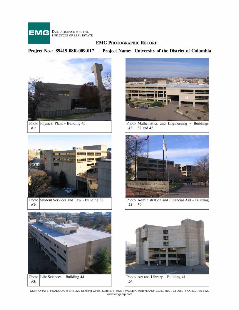
EMG PHOTOGRAPHIC RECORD
Project No.: 89419.08R-009.017 Project Name: University of the District of Columbia
CORPORATE HEADQUARTERS 222 Schilling Circle, Suite 275 HUNT VALLEY, MARYLAND 21031 800 733 0660 FAX 410 785 6220 www.emgcorp.com
Photo #1:
Physical Plant – Building 43 Photo #2:
Mathematics and Engineering – Buildings 32 and 42
Photo #3:
Student Services and Law - Building 38 Photo #4:
Administration and Financial Aid – Building 39
Photo #5:
Life Sciences – Building 44 Photo #6:
Art and Library – Building 41
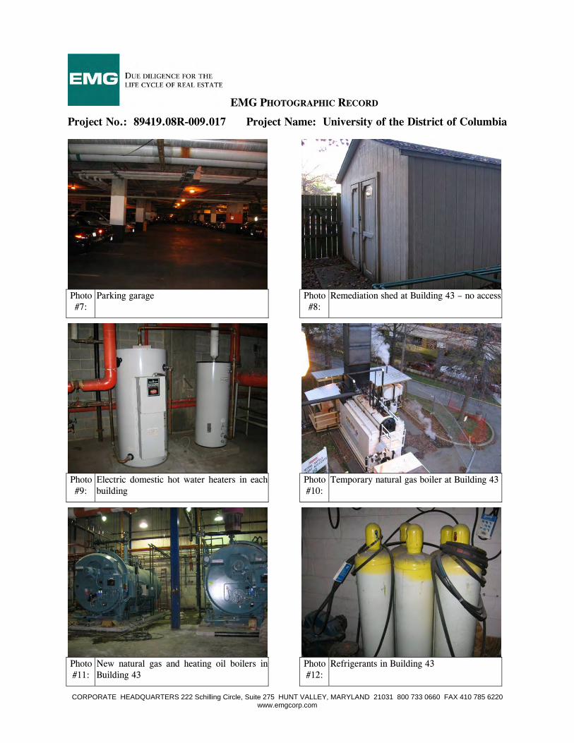
EMG PHOTOGRAPHIC RECORD
Project No.: 89419.08R-009.017 Project Name: University of the District of Columbia
CORPORATE HEADQUARTERS 222 Schilling Circle, Suite 275 HUNT VALLEY, MARYLAND 21031 800 733 0660 FAX 410 785 6220 www.emgcorp.com
Photo #7:
Parking garage Photo #8:
Remediation shed at Building 43 – no access
Photo #9:
Electric domestic hot water heaters in each building
Photo #10:
Temporary natural gas boiler at Building 43
Photo #11:
New natural gas and heating oil boilers in Building 43
Photo #12:
Refrigerants in Building 43
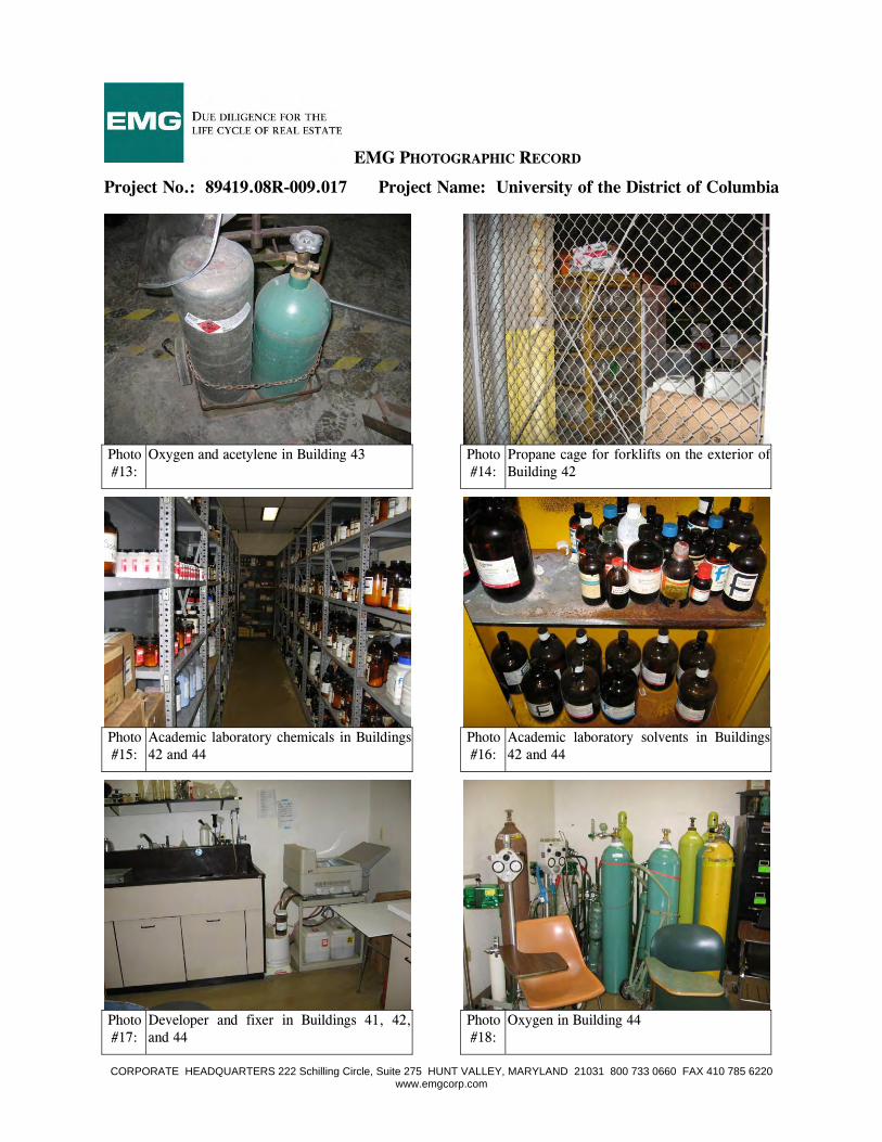
EMG PHOTOGRAPHIC RECORD
Project No.: 89419.08R-009.017 Project Name: University of the District of Columbia
CORPORATE HEADQUARTERS 222 Schilling Circle, Suite 275 HUNT VALLEY, MARYLAND 21031 800 733 0660 FAX 410 785 6220 www.emgcorp.com
Photo #13:
Oxygen and acetylene in Building 43 Photo #14:
Propane cage for forklifts on the exterior of Building 42
Photo #15:
Academic laboratory chemicals in Buildings 42 and 44
Photo #16:
Academic laboratory solvents in Buildings 42 and 44
Photo #17:
Developer and fixer in Buildings 41, 42, and 44
Photo #18:
Oxygen in Building 44
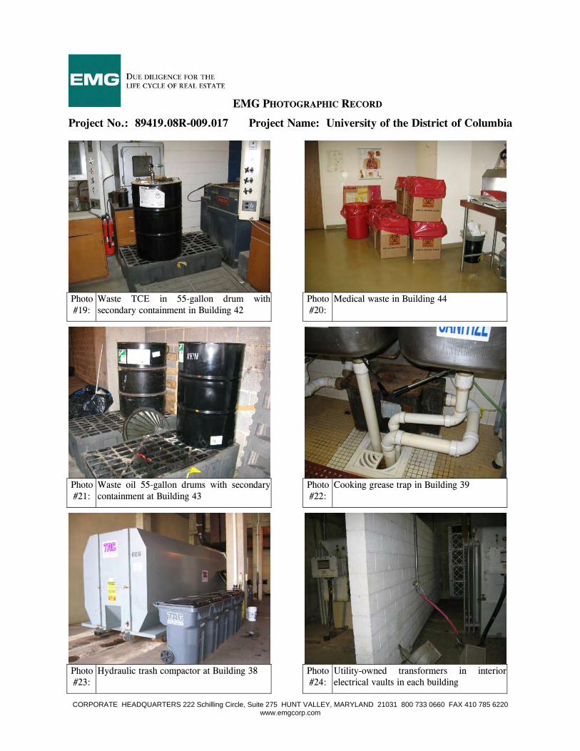
EMG PHOTOGRAPHIC RECORD
Project No.: 89419.08R-009.017 Project Name: University of the District of Columbia
CORPORATE HEADQUARTERS 222 Schilling Circle, Suite 275 HUNT VALLEY, MARYLAND 21031 800 733 0660 FAX 410 785 6220 www.emgcorp.com
Photo #19:
Waste TCE in 55-gallon drum with secondary containment in Building 42
Photo #20:
Medical waste in Building 44
Photo #21:
Waste oil 55-gallon drums with secondary containment at Building 43
Photo #22:
Cooking grease trap in Building 39
Photo #23:
Hydraulic trash compactor at Building 38 Photo #24:
Utility-owned transformers in interior electrical vaults in each building
EMG PHOTOGRAPHIC RECORD
Project No.: 89419.08R-009.017 Project Name: University of the District of Columbia
CORPORATE HEADQUARTERS 222 Schilling Circle, Suite 275 HUNT VALLEY, MARYLAND 21031 800 733 0660 FAX 410 785 6220 www.emgcorp.com
Photo #25:
Step down transformer Photo #26:
Hydraulic elevator
Photo #27:
Two of 14 traction elevators at the Project Photo #28:
Homeland Security rooftop diesel belly tank for emergency generator on Building 41
Photo #29:
Former radio station 45-gallon day tank for rooftop emergency generator on Building 39
Photo #30:
Two 8,000-gallon fuel oil ASTs (and former location of three 30,000-gallon USTs)

EMG PHOTOGRAPHIC RECORD
Project No.: 89419.08R-009.017 Project Name: University of the District of Columbia
CORPORATE HEADQUARTERS 222 Schilling Circle, Suite 275 HUNT VALLEY, MARYLAND 21031 800 733 0660 FAX 410 785 6220 www.emgcorp.com
Photo #31:
Emergency generator and 250-gallon day tank in Building 43
Photo #32:
Generator associated with Photo #31
Photo #33:
One of eight ground water monitoring wells located north of Building 43
Photo #34:
Water damaged painted dry wall in break room of Building 43
Photo #35:
Water damaged ceiling tile in Building 32 Photo #36:
Water damaged ceiling tile in Buildings 38 and 39
EMG PHOTOGRAPHIC RECORD
Project No.: 89419.08R-009.017 Project Name: University of the District of Columbia
CORPORATE HEADQUARTERS 222 Schilling Circle, Suite 275 HUNT VALLEY, MARYLAND 21031 800 733 0660 FAX 410 785 6220 www.emgcorp.com
Photo #37:
Water damaged painted drywall ceiling in the Building 39 copy room
Photo #38:
Water damaged ceiling tiles, drywall, and floor tiles in Building 44 Room 311
Photo #39:
Significant water damage throughout Building 41
Photo #40:
Significant water damage throughout the parking garage
Photo #41:
Adjoining north – commercial and office building with a metro entrance
Photo #42:
Adjacent east – Embassy Cleaners (regulatory report listings)
EMG PHOTOGRAPHIC RECORD
Project No.: 89419.08R-009.017 Project Name: University of the District of Columbia
CORPORATE HEADQUARTERS 222 Schilling Circle, Suite 275 HUNT VALLEY, MARYLAND 21031 800 733 0660 FAX 410 785 6220 www.emgcorp.com
Photo #43:
Adjacent east - Van Ness Auto Care (regulatory report listings)
Photo #44:
Adjacent east – CVS and Giant grocery (regulatory report listings)
Photo #45:
Adjacent southeast - residential Photo #46:
Adjacent south – Intelsat (regulatory report listings)
Photo #47:
Adjoining west – University of the District of Columbia playing field
Photo #48:
Overview of Project, facing east
8899441199 .. 0088RR-- 000099 .. 001177
DUE DILIGENCE FOR THE LIFE CYCLE OF REAL ESTATE. 800.733.0660 • www.emgcorp.com
A S S E S S M E N T E N V I R O N M E N T A L
AA PP PP EE NN DD II XX BB :: FF II EE LL DD SS KK EE TT CC HH
Field Sketch
Project Number:
89419.08R-009.017
Key: Project Boundary Aboveground Storage Tank Former Underground Storage Tank Monitoring Well E – Emergency Generator C – Trash Compactor
Project Name:
University of the District of Columbia
Not drawn to scale. The north arrow indicator is an approximation of 0° North.
On-Site Date:
December 3-5, 2008
Office and Commercial
Building with Metro Entrance
(4250 Connecticut . Avenue, NW)
Building #44
Building #41
Building #32
Building #42
Building #38
Parking Garage
Building #39
Building #43
Building 46W Building #46E
Tennis Courts
Building #47
Connecticut
Avenue,
NW
Windom Place, NW
Veazey Terrace, NW
Van Ness Street, NW
International D
rive, NW
Van Ness Auto Care and Gasoline Station
(4225 Connecticut Avenue, NW) FINDS, UST, RCRA-CESQG, Manifest, EDR Historical Auto
Stations, and LUST
Van Ness Shopping Center (4301-4309 Connecticut
Avenue, NW) UST
Potbelly Sandwich Works (4300 Connecticut Avenue, NW)
Former Gasoline Station
UDC Playing Field
Singapore Embassy (3501 International Place, NW)
Intelsat (3400 International Drive, NW)
UST, Manifest, and RCRA-CESQG Residential Townhouses
(4111-4123 Connecticut Avenue, NW)
University of the District of Columbia (4200 Connecticut Avenue, NW)
FINDS, ICIS, MLTS, LUST, UST, CERC-NFRAP, RCRA-LQG, and Manifest
Liquor Store, Jerry’s Subs, Office Building
(4201 Connecticut Avenue, NW)EDR Historical Auto
Stations and UST
Embassy Cleaners (4215 Connecticut Avenue, NW)
FINDS ad RCRA-CESQG
Diamond Ordnance Fuze Lab (Connecticut Avenue, NW and Windom Place)
CERCLIS and FUDS
KFC, Taco Bell, Green Apple, and Cadian Ocean
(4221 Connecticut Avenue, NW)
C
E
E
E

8899441199 .. 0088RR-- 000099 .. 001177
DUE DILIGENCE FOR THE LIFE CYCLE OF REAL ESTATE. 800.733.0660 • www.emgcorp.com
A S S E S S M E N T E N V I R O N M E N T A L
AA PP PP EE NN DD II XX CC :: MM AA PP SS AA NN DD AA EE RR II AA LL PP HH OO TT OO GG RR AA PP HH SS
Topographic Map
Project Number:
89419.08R-009.017
Project Name:
University of the District of Columbia
Source:
USGS Topographic Quadrangle: Washington West, District of Columbia Date: 1965 (Photorevised 1983) The north arrow indicator is an approximation of 0° North.
On-Site Date:
December 3-5, 2008
Floodplain Map
Project Number:
89419.08R-009.017
Project Name:
University of the District of Columbia
Source:
FEMA Date: 1985 The north arrow indicator is an approximation of 0° North.
On-Site Date:
December 3-5, 2008
Wetlands Map
Project Number:
89419.08R-009.017
Project Name:
University of the District of Columbia
Source:
United States Fish and Wildlife Services Date: 2005 The north arrow indicator is an approximation of 0° North.
On-Site Date:
December 3-5, 2008
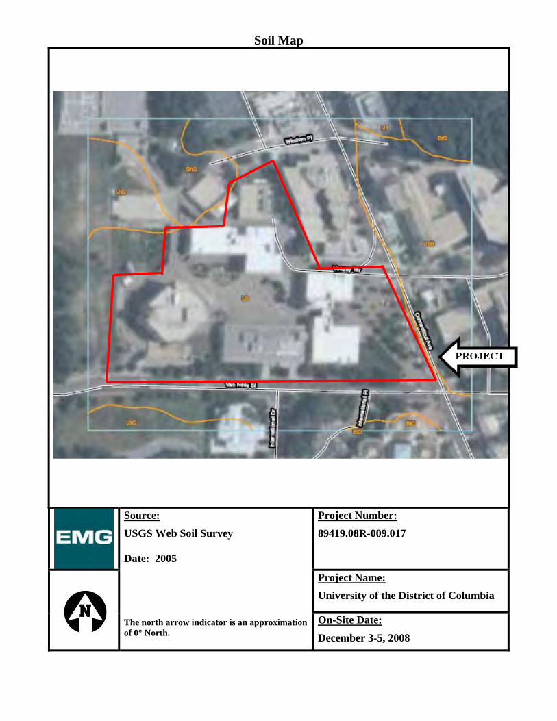
Soil Map
Project Number:
89419.08R-009.017
Project Name:
University of the District of Columbia
Source:
USGS Web Soil Survey Date: 2005 The north arrow indicator is an approximation of 0° North.
On-Site Date:
December 3-5, 2008
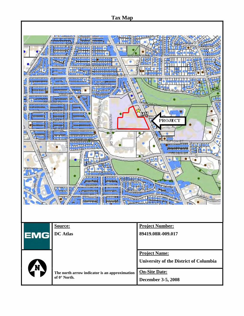
Tax Map
Project Number:
89419.08R-009.017
Project Name:
University of the District of Columbia
Source:
DC Atlas The north arrow indicator is an approximation of 0° North.
On-Site Date:
December 3-5, 2008
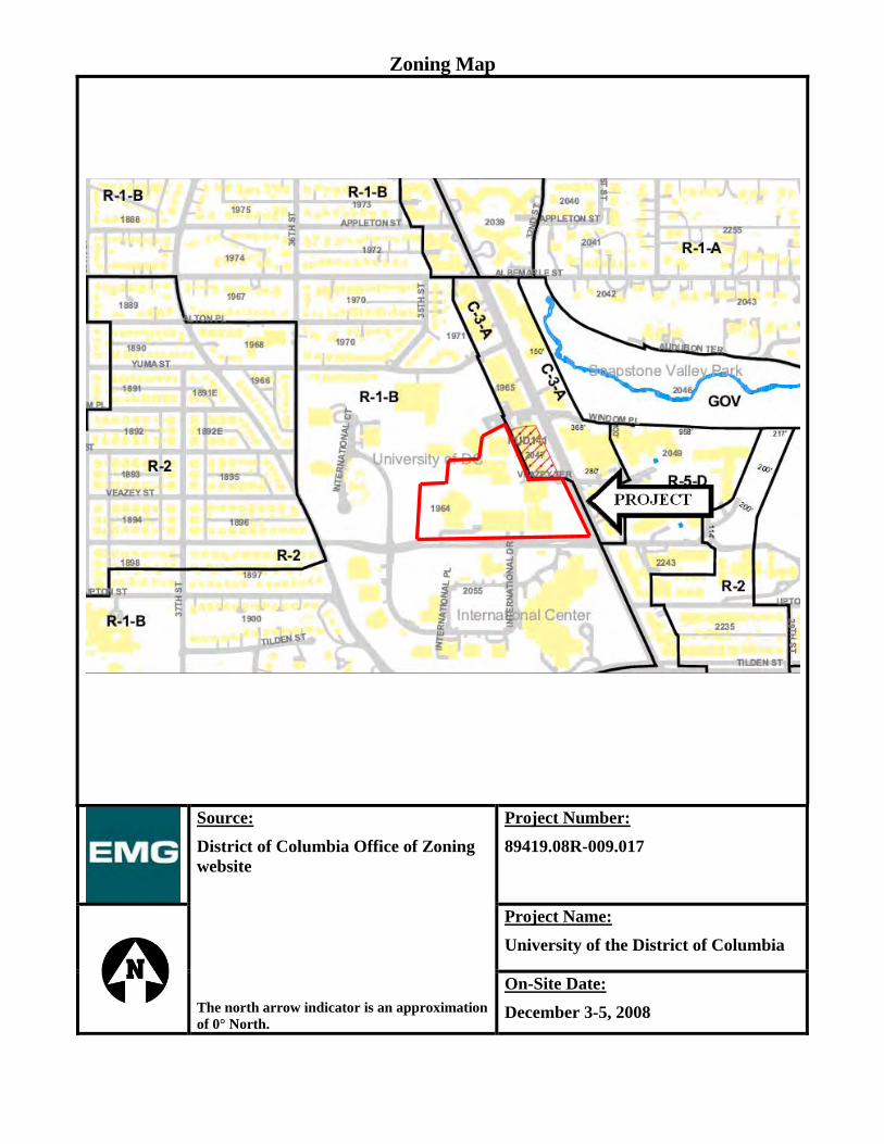
Zoning Map
Project Number:
89419.08R-009.017
Project Name:
University of the District of Columbia
Source:
District of Columbia Office of Zoning website The north arrow indicator is an approximation of 0° North.
On-Site Date:
December 3-5, 2008
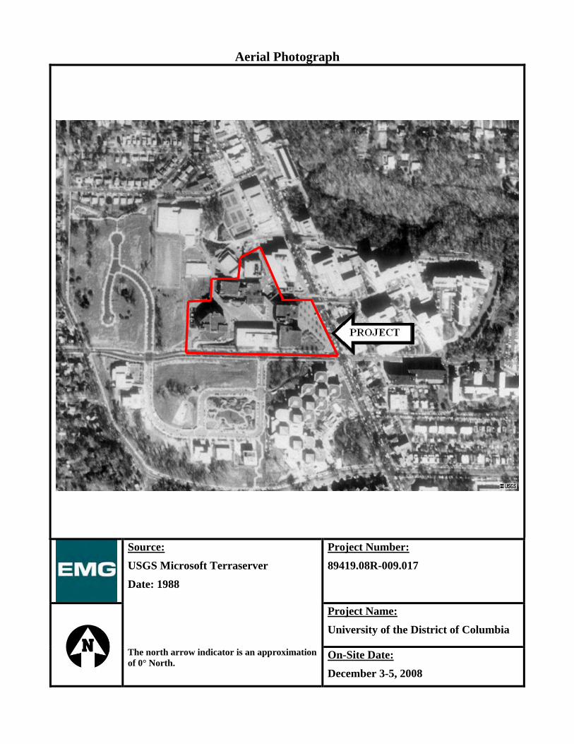
Aerial Photograph
Project Number:
89419.08R-009.017
Project Name:
University of the District of Columbia
Source:
USGS Microsoft Terraserver
Date: 1988 The north arrow indicator is an approximation of 0° North.
On-Site Date:
December 3-5, 2008

Aerial Photograph
Project Number:
89419.08R-009.017
Project Name:
University of the District of Columbia
Source:
USGS Microsoft Terraserver
Date: 2002 The north arrow indicator is an approximation of 0° North.
On-Site Date:
December 3-5, 2008

8899441199 .. 0088RR-- 000099 .. 001177
DUE DILIGENCE FOR THE LIFE CYCLE OF REAL ESTATE. 800.733.0660 • www.emgcorp.com
A S S E S S M E N T E N V I R O N M E N T A L
AA PP PP EE NN DD II XX DD :: RR EE CC OO RR DD SS OO FF CC OO MM MM UU NN II CC AA TT II OO NN
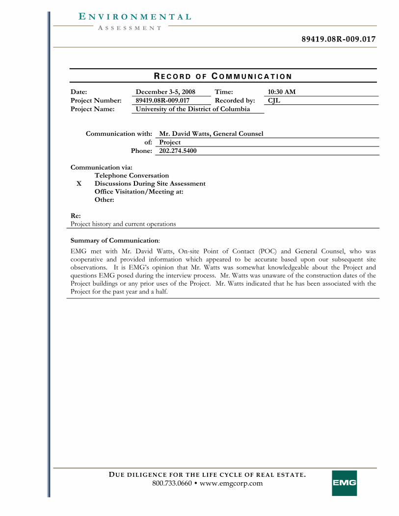
8899441199 .. 0088RR-- 000099 .. 001177
DUE DILIGENCE FOR THE LIFE CYCLE OF REAL ESTATE. 800.733.0660 • www.emgcorp.com
A S S E S S M E N T E N V I R O N M E N T A L
RR EE CC OO RR DD OO FF CC OO MM MM UU NN II CC AA TT II OO NN
Date: December 3-5, 2008 Time: 10:30 AM Project Number: 89419.08R-009.017 Recorded by: CJL Project Name: University of the District of Columbia
Communication with: Mr. David Watts, General Counsel of: Project
Phone: 202.274.5400 Communication via:
Telephone Conversation X Discussions During Site Assessment Office Visitation/Meeting at: Other:
Re: Project history and current operations Summary of Communication: EMG met with Mr. David Watts, On-site Point of Contact (POC) and General Counsel, who was cooperative and provided information which appeared to be accurate based upon our subsequent site observations. It is EMG’s opinion that Mr. Watts was somewhat knowledgeable about the Project and questions EMG posed during the interview process. Mr. Watts was unaware of the construction dates of the Project buildings or any prior uses of the Project. Mr. Watts indicated that he has been associated with the Project for the past year and a half.
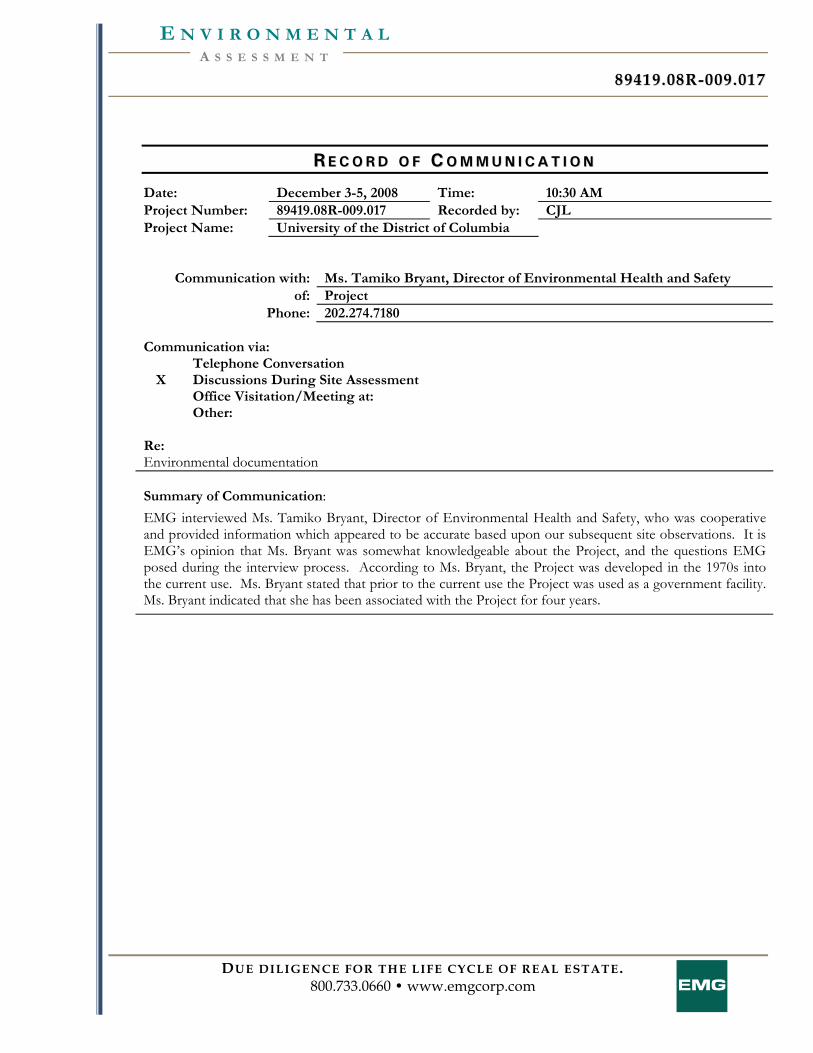
8899441199 .. 0088RR-- 000099 .. 001177
DUE DILIGENCE FOR THE LIFE CYCLE OF REAL ESTATE. 800.733.0660 • www.emgcorp.com
A S S E S S M E N T E N V I R O N M E N T A L
RR EE CC OO RR DD OO FF CC OO MM MM UU NN II CC AA TT II OO NN
Date: December 3-5, 2008 Time: 10:30 AM Project Number: 89419.08R-009.017 Recorded by: CJL Project Name: University of the District of Columbia
Communication with: Ms. Tamiko Bryant, Director of Environmental Health and Safety of: Project
Phone: 202.274.7180 Communication via:
Telephone Conversation X Discussions During Site Assessment Office Visitation/Meeting at: Other:
Re: Environmental documentation Summary of Communication: EMG interviewed Ms. Tamiko Bryant, Director of Environmental Health and Safety, who was cooperative and provided information which appeared to be accurate based upon our subsequent site observations. It is EMG’s opinion that Ms. Bryant was somewhat knowledgeable about the Project, and the questions EMG posed during the interview process. According to Ms. Bryant, the Project was developed in the 1970s into the current use. Ms. Bryant stated that prior to the current use the Project was used as a government facility. Ms. Bryant indicated that she has been associated with the Project for four years.
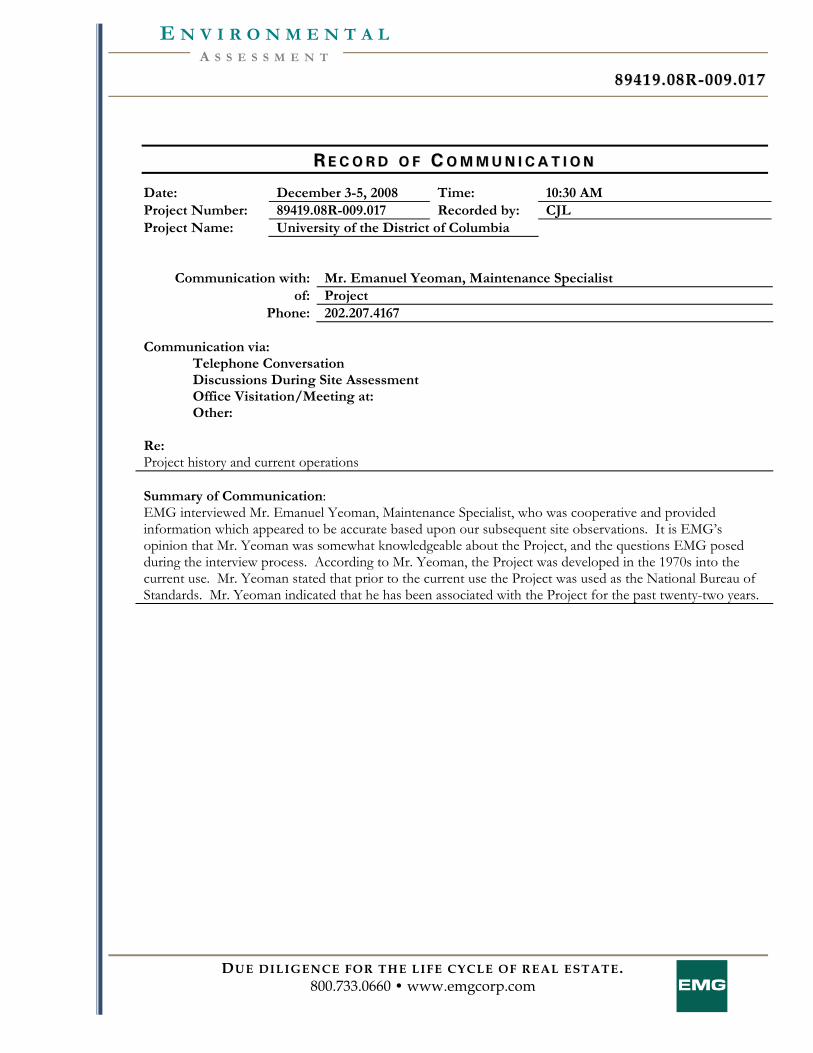
8899441199 .. 0088RR-- 000099 .. 001177
DUE DILIGENCE FOR THE LIFE CYCLE OF REAL ESTATE. 800.733.0660 • www.emgcorp.com
A S S E S S M E N T E N V I R O N M E N T A L
RR EE CC OO RR DD OO FF CC OO MM MM UU NN II CC AA TT II OO NN
Date: December 3-5, 2008 Time: 10:30 AM Project Number: 89419.08R-009.017 Recorded by: CJL Project Name: University of the District of Columbia
Communication with: Mr. Emanuel Yeoman, Maintenance Specialist of: Project
Phone: 202.207.4167 Communication via:
Telephone Conversation Discussions During Site Assessment Office Visitation/Meeting at: Other:
Re: Project history and current operations Summary of Communication: EMG interviewed Mr. Emanuel Yeoman, Maintenance Specialist, who was cooperative and provided information which appeared to be accurate based upon our subsequent site observations. It is EMG’s opinion that Mr. Yeoman was somewhat knowledgeable about the Project, and the questions EMG posed during the interview process. According to Mr. Yeoman, the Project was developed in the 1970s into the current use. Mr. Yeoman stated that prior to the current use the Project was used as the National Bureau of Standards. Mr. Yeoman indicated that he has been associated with the Project for the past twenty-two years.
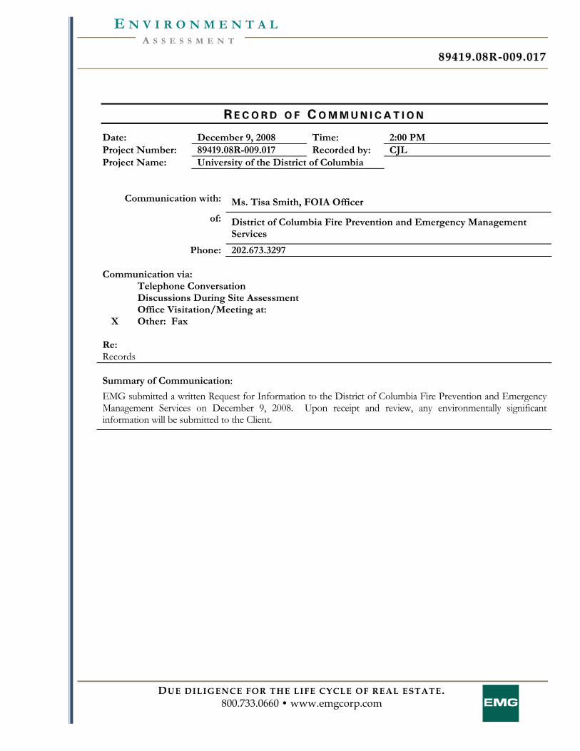
8899441199 .. 0088RR-- 000099 .. 001177
DUE DILIGENCE FOR THE LIFE CYCLE OF REAL ESTATE. 800.733.0660 • www.emgcorp.com
A S S E S S M E N T E N V I R O N M E N T A L
RR EE CC OO RR DD OO FF CC OO MM MM UU NN II CC AA TT II OO NN
Date: December 9, 2008 Time: 2:00 PM Project Number: 89419.08R-009.017 Recorded by: CJL Project Name: University of the District of Columbia
Communication with: Ms. Tisa Smith, FOIA Officer
of: District of Columbia Fire Prevention and Emergency Management Services
Phone: 202.673.3297 Communication via:
Telephone Conversation Discussions During Site Assessment Office Visitation/Meeting at:
X Other: Fax Re: Records Summary of Communication: EMG submitted a written Request for Information to the District of Columbia Fire Prevention and Emergency Management Services on December 9, 2008. Upon receipt and review, any environmentally significant information will be submitted to the Client.
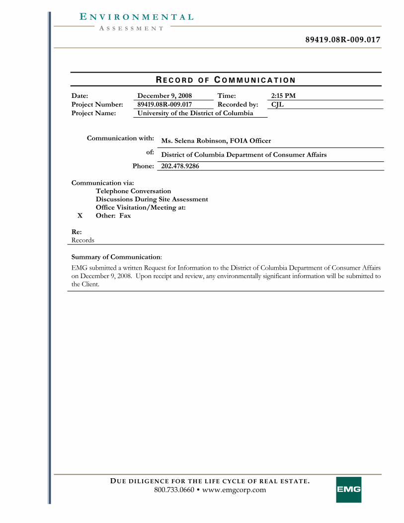
8899441199 .. 0088RR-- 000099 .. 001177
DUE DILIGENCE FOR THE LIFE CYCLE OF REAL ESTATE. 800.733.0660 • www.emgcorp.com
A S S E S S M E N T E N V I R O N M E N T A L
RR EE CC OO RR DD OO FF CC OO MM MM UU NN II CC AA TT II OO NN
Date: December 9, 2008 Time: 2:15 PM Project Number: 89419.08R-009.017 Recorded by: CJL Project Name: University of the District of Columbia
Communication with: Ms. Selena Robinson, FOIA Officer
of: District of Columbia Department of Consumer Affairs
Phone: 202.478.9286 Communication via:
Telephone Conversation Discussions During Site Assessment Office Visitation/Meeting at:
X Other: Fax Re: Records Summary of Communication: EMG submitted a written Request for Information to the District of Columbia Department of Consumer Affairs on December 9, 2008. Upon receipt and review, any environmentally significant information will be submitted to the Client.
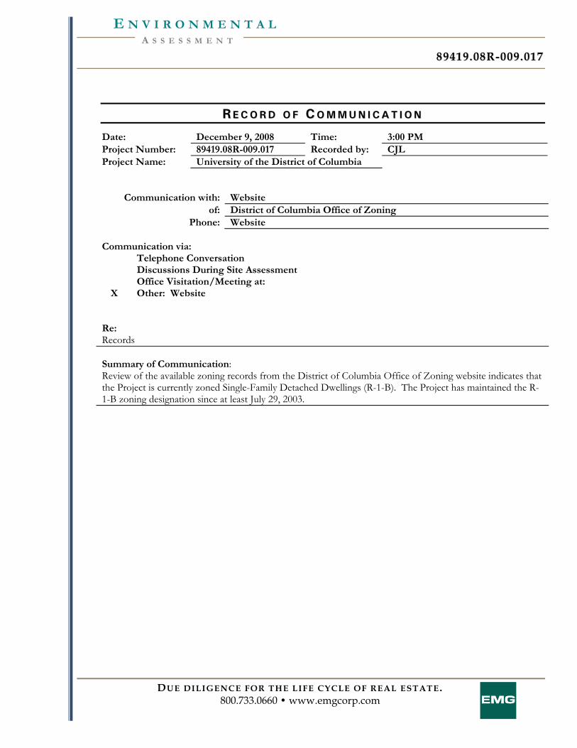
8899441199 .. 0088RR-- 000099 .. 001177
DUE DILIGENCE FOR THE LIFE CYCLE OF REAL ESTATE. 800.733.0660 • www.emgcorp.com
A S S E S S M E N T E N V I R O N M E N T A L
RR EE CC OO RR DD OO FF CC OO MM MM UU NN II CC AA TT II OO NN
Date: December 9, 2008 Time: 3:00 PM Project Number: 89419.08R-009.017 Recorded by: CJL Project Name: University of the District of Columbia
Communication with: Website of: District of Columbia Office of Zoning
Phone: Website Communication via:
Telephone Conversation Discussions During Site Assessment Office Visitation/Meeting at:
X Other: Website
Re: Records Summary of Communication: Review of the available zoning records from the District of Columbia Office of Zoning website indicates that the Project is currently zoned Single-Family Detached Dwellings (R-1-B). The Project has maintained the R-1-B zoning designation since at least July 29, 2003.

8899441199 .. 0088RR-- 000099 .. 001177
DUE DILIGENCE FOR THE LIFE CYCLE OF REAL ESTATE. 800.733.0660 • www.emgcorp.com
A S S E S S M E N T E N V I R O N M E N T A L
AA PP PP EE NN DD II XX EE :: QQ UU EE SS TT II OO NN NN AA II RR EE SS
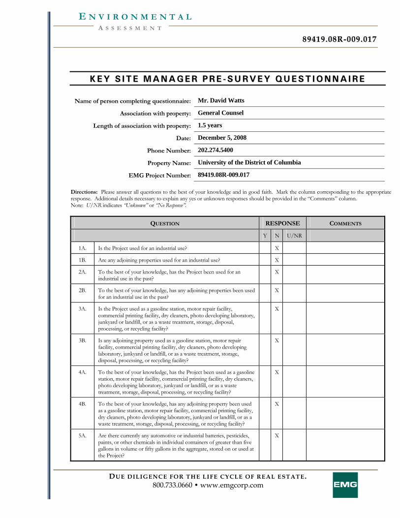
8899441199 .. 0088RR-- 000099 .. 001177
DUE DILIGENCE FOR THE LIFE CYCLE OF REAL ESTATE. 800.733.0660 • www.emgcorp.com
A S S E S S M E N T E N V I R O N M E N T A L
KK EE YY SS II TT EE MM AA NN AA GG EE RR PP RR EE -- SS UU RR VV EE YY QQ UU EE SS TT II OO NN NN AA II RR EE
Name of person completing questionnaire: Mr. David Watts
Association with property: General Counsel
Length of association with property: 1.5 years
Date: December 5, 2008
Phone Number: 202.274.5400
Property Name: University of the District of Columbia
EMG Project Number: 89419.08R-009.017 Directions: Please answer all questions to the best of your knowledge and in good faith. Mark the column corresponding to the appropriate response. Additional details necessary to explain any yes or unknown responses should be provided in the “Comments” column. Note: U/NR indicates “Unknown” or “No Response”.
QUESTION RESPONSE COMMENTS
Y N U/NR
1A. Is the Project used for an industrial use? X
1B. Are any adjoining properties used for an industrial use? X
2A. To the best of your knowledge, has the Project been used for an industrial use in the past?
X
2B. To the best of your knowledge, has any adjoining properties been used for an industrial use in the past?
X
3A. Is the Project used as a gasoline station, motor repair facility, commercial printing facility, dry cleaners, photo developing laboratory, junkyard or landfill, or as a waste treatment, storage, disposal, processing, or recycling facility?
X
3B. Is any adjoining property used as a gasoline station, motor repair facility, commercial printing facility, dry cleaners, photo developing laboratory, junkyard or landfill, or as a waste treatment, storage, disposal, processing, or recycling facility?
X
4A. To the best of your knowledge, has the Project been used as a gasoline station, motor repair facility, commercial printing facility, dry cleaners, photo developing laboratory, junkyard or landfill, or as a waste treatment, storage, disposal, processing, or recycling facility?
X
4B. To the best of your knowledge, has any adjoining property been used as a gasoline station, motor repair facility, commercial printing facility, dry cleaners, photo developing laboratory, junkyard or landfill, or as a waste treatment, storage, disposal, processing, or recycling facility?
X
5A. Are there currently any automotive or industrial batteries, pesticides, paints, or other chemicals in individual containers of greater than five gallons in volume or fifty gallons in the aggregate, stored on or used at the Project?
X
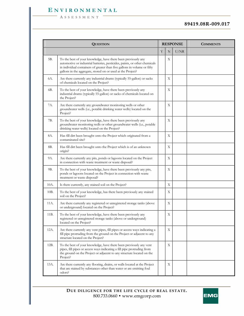
8899441199 .. 0088RR-- 000099 .. 001177
DUE DILIGENCE FOR THE LIFE CYCLE OF REAL ESTATE. 800.733.0660 • www.emgcorp.com
A S S E S S M E N T E N V I R O N M E N T A L
QUESTION RESPONSE COMMENTS
Y N U/NR
5B. To the best of your knowledge, have there been previously any automotive or industrial batteries, pesticides, paints, or other chemicals in individual containers of greater than five gallons in volume or fifty gallons in the aggregate, stored on or used at the Project?
X
6A. Are there currently any industrial drums (typically 55-gallon) or sacks of chemicals located on the Project?
X
6B. To the best of your knowledge, have there been previously any industrial drums (typically 55-gallon) or sacks of chemicals located on the Project?
X
7A. Are there currently any groundwater monitoring wells or other groundwater wells (i.e., potable drinking water wells) located on the Project?
X
7B. To the best of your knowledge, have there been previously any groundwater monitoring wells or other groundwater wells (i.e., potable drinking water wells) located on the Project?
X
8A. Has fill dirt been brought onto the Project which originated from a contaminated site?
X
8B. Has fill dirt been brought onto the Project which is of an unknown origin?
X
9A. Are there currently any pits, ponds or lagoons located on the Project in connection with waste treatment or waste disposal?
X
9B. To the best of your knowledge, have there been previously any pits, ponds or lagoons located on the Project in connection with waste treatment or waste disposal?
X
10A. Is there currently, any stained soil on the Project? X
10B. To the best of your knowledge, has there been previously any stained soil on the Project?
X
11A. Are there currently any registered or unregistered storage tanks (above or underground) located on the Project?
X
11B. To the best of your knowledge, have there been previously any registered or unregistered storage tanks (above or underground) located on the Project?
X
12A. Are there currently any vent pipes, fill pipes or access ways indicating a fill pipe protruding from the ground on the Project or adjacent to any structure located on the Project?
X
12B. To the best of your knowledge, have there been previously any vent pipes, fill pipes or access ways indicating a fill pipe protruding from the ground on the Project or adjacent to any structure located on the Project?
X
13A. Are there currently any flooring, drains, or walls located at the Project that are stained by substances other than water or are emitting foul odors?
X
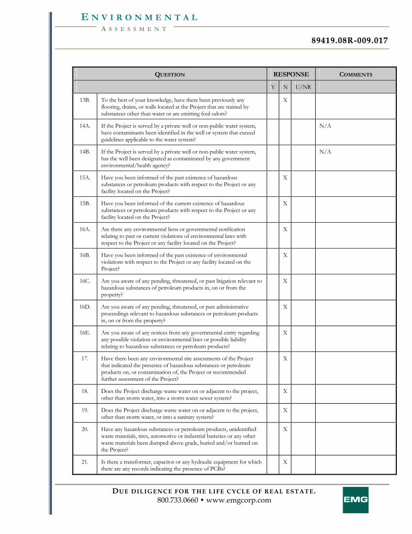
8899441199 .. 0088RR-- 000099 .. 001177
DUE DILIGENCE FOR THE LIFE CYCLE OF REAL ESTATE. 800.733.0660 • www.emgcorp.com
A S S E S S M E N T E N V I R O N M E N T A L
QUESTION RESPONSE COMMENTS
Y N U/NR
13B. To the best of your knowledge, have there been previously any flooring, drains, or walls located at the Project that are stained by substances other than water or are emitting foul odors?
X
14A. If the Project is served by a private well or non-public water system, have contaminants been identified in the well or system that exceed guidelines applicable to the water system?
N/A
14B. If the Project is served by a private well or non-public water system, has the well been designated as contaminated by any government environmental/health agency?
N/A
15A. Have you been informed of the past existence of hazardous substances or petroleum products with respect to the Project or any facility located on the Project?
X
15B. Have you been informed of the current existence of hazardous substances or petroleum products with respect to the Project or any facility located on the Project?
X
16A. Are there any environmental liens or governmental notification relating to past or current violations of environmental laws with respect to the Project or any facility located on the Project?
X
16B. Have you been informed of the past existence of environmental violations with respect to the Project or any facility located on the Project?
X
16C. Are you aware of any pending, threatened, or past litigation relevant to hazardous substances of petroleum products in, on or from the property?
X
16D. Are you aware of any pending, threatened, or past administrative proceedings relevant to hazardous substances or petroleum products in, on or from the property?
X
16E. Are you aware of any notices from any governmental entity regarding any possible violation or environmental laws or possible liability relating to hazardous substances or petroleum products?
X
17. Have there been any environmental site assessments of the Project that indicated the presence of hazardous substances or petroleum products on, or contamination of, the Project or recommended further assessment of the Project?
X
18. Does the Project discharge waste water on or adjacent to the project, other than storm water, into a storm water sewer system?
X
19. Does the Project discharge waste water on or adjacent to the project, other than storm water, or into a sanitary system?
X
20. Have any hazardous substances or petroleum products, unidentified waste materials, tires, automotive or industrial batteries or any other waste materials been dumped above grade, buried and/or burned on the Project?
X
21. Is there a transformer, capacitor or any hydraulic equipment for which there are any records indicating the presence of PCBs?
X
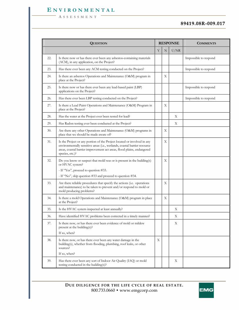
8899441199 .. 0088RR-- 000099 .. 001177
DUE DILIGENCE FOR THE LIFE CYCLE OF REAL ESTATE. 800.733.0660 • www.emgcorp.com
A S S E S S M E N T E N V I R O N M E N T A L
QUESTION RESPONSE COMMENTS
Y N U/NR
22. Is there now or has there ever been any asbestos-containing materials (ACM), in any application, on the Project?
Impossible to respond
23. Has there ever been any ACM testing conducted on the Project? Impossible to respond
24. Is there an asbestos Operations and Maintenance (O&M) program in place at the Project?
X
25. Is there now or has there ever been any lead-based paint (LBP) applications on the Project?
Impossible to respond
26. Has there ever been LBP testing conducted on the Project? Impossible to respond
27. Is there a Lead Paint Operations and Maintenance (O&M) Program in place at the Project?
X
28. Has the water at the Project ever been tested for lead? X
29. Has Radon testing ever been conducted at the Project? X
30. Are there any other Operations and Maintenance (O&M) programs in place that we should be made aware of?
X
31. Is the Project or any portion of the Project located or involved in any environmentally sensitive areas (i.e., wetlands, coastal barrier resource areas, coastal barrier improvement act areas, flood plains, endangered species, etc.)?
X
32. Do you know or suspect that mold was or is present in the building(s) or HVAC system?
- If “Yes”, proceed to question #33.
- If “No”, skip question #33 and proceed to question #34.
X
33. Are there reliable procedures that specify the actions (i.e. operations and maintenance) to be taken to prevent and/or respond to mold or mold producing problems?
X
34. Is there a mold Operations and Maintenance (O&M) program in place at the Project?
X
35. Is the HVAC system inspected at least annually? X
36. Have identified HVAC problems been corrected in a timely manner? X
37. Is there now, or has there ever been evidence of mold or mildew present at the building(s)?
If so, when?
X
38. Is there now, or has there ever been any water damage in the building(s), whether from flooding, plumbing, roof leaks, or other sources?
If so, when?
X
39. Has there ever been any sort of Indoor Air Quality (IAQ) or mold testing conducted in the building(s)?
X
8899441199 .. 0088RR-- 000099 .. 001177
DUE DILIGENCE FOR THE LIFE CYCLE OF REAL ESTATE. 800.733.0660 • www.emgcorp.com
A S S E S S M E N T E N V I R O N M E N T A L
QUESTION RESPONSE COMMENTS
Y N U/NR
Summarize historical Project use (when was the Project developed with the current improvements, what modifications have taken place, what was the Project used for prior to it's current use)
Yes.
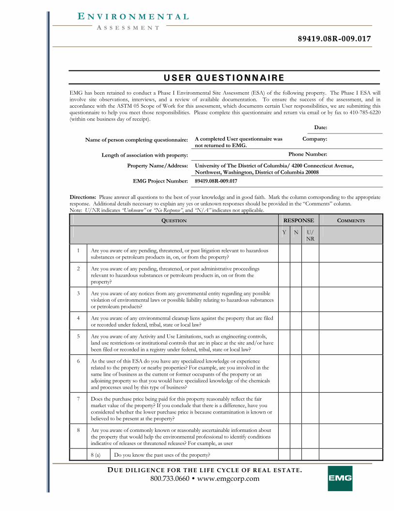
8899441199 .. 0088RR-- 000099 .. 001177
DUE DILIGENCE FOR THE LIFE CYCLE OF REAL ESTATE. 800.733.0660 • www.emgcorp.com
A S S E S S M E N T E N V I R O N M E N T A L
UU SS EE RR QQ UU EE SS TT II OO NN NN AA II RR EE
EMG has been retained to conduct a Phase I Environmental Site Assessment (ESA) of the following property. The Phase I ESA will involve site observations, interviews, and a review of available documentation. To ensure the success of the assessment, and in accordance with the ASTM 05 Scope of Work for this assessment, which documents certain User responsibilities, we are submitting this questionnaire to help you meet those responsibilities. Please complete this questionnaire and return via email or by fax to 410-785-6220 (within one business day of receipt).
Date:
Name of person completing questionnaire: A completed User questionnaire was not returned to EMG.
Company:
Length of association with property: Phone Number:
Property Name/Address: University of The District of Columbia/ 4200 Connecticut Avenue, Northwest, Washington, District of Columbia 20008
EMG Project Number: 89419.08R-009.017
Directions: Please answer all questions to the best of your knowledge and in good faith. Mark the column corresponding to the appropriate response. Additional details necessary to explain any yes or unknown responses should be provided in the “Comments” column. Note: U/NR indicates “Unknown” or “No Response”, and “N/A” indicates not applicable.
QUESTION RESPONSE COMMENTS
Y N U/NR
1 Are you aware of any pending, threatened, or past litigation relevant to hazardous substances or petroleum products in, on, or from the property?
2 Are you aware of any pending, threatened, or past administrative proceedings relevant to hazardous substances or petroleum products in, on or from the property?
3 Are you aware of any notices from any governmental entity regarding any possible violation of environmental laws or possible liability relating to hazardous substances or petroleum products?
4 Are you aware of any environmental cleanup liens against the property that are filed or recorded under federal, tribal, state or local law?
5 Are you aware of any Activity and Use Limitations, such as engineering controls, land use restrictions or institutional controls that are in place at the site and/or have been filed or recorded in a registry under federal, tribal, state or local law?
6 As the user of this ESA do you have any specialized knowledge or experience related to the property or nearby properties? For example, are you involved in the same line of business as the current or former occupants of the property or an adjoining property so that you would have specialized knowledge of the chemicals and processes used by this type of business?
7 Does the purchase price being paid for this property reasonably reflect the fair market value of the property? If you conclude that there is a difference, have you considered whether the lower purchase price is because contamination is known or believed to be present at the property?
8 Are you aware of commonly known or reasonably ascertainable information about the property that would help the environmental professional to identify conditions indicative of releases or threatened releases? For example, as user
8 (a) Do you know the past uses of the property?
8899441199 .. 0088RR-- 000099 .. 001177
DUE DILIGENCE FOR THE LIFE CYCLE OF REAL ESTATE. 800.733.0660 • www.emgcorp.com
A S S E S S M E N T E N V I R O N M E N T A L
QUESTION RESPONSE COMMENTS
Y N U/NR
8 (b) Do you know of specific chemicals that are present or once were present at the property?
8 (c) Do you know of spills or other chemical releases that have taken place at the property?
8 (d) Do you know of any environmental cleanups that have taken place at the property?
9 As the user of this ESA, based on your knowledge and experience related to the property are there any obvious indicators that point to the presence or likely presence of contamination at the property?
In addition, are you aware of any of the following documents, and if so, please forward copies of the document(s) to EMG at 11011 McCormick Road, Hunt Valley, Maryland 21031 (along with a copy of this form):
Helpful Documents to be forwarded EMG:
Environmental site assessment reports (i.e., Phase I, Phase II, tank testing results, radon, lead paint, or asbestos testing, etc.)
Environmental compliance audit reports; risk assessments; and recorded Activity and Use Limitations (AULs)
Environmental permits (i.e., solid waste disposal, hazardous waste disposal, wastewater, NPDES, underground injection, etc.)
Registrations for underground storage tanks (USTs) and aboveground storage tanks (ASTs) Registrations for underground injection systems Material safety data sheets Community right-to-know plan Safety plans; preparedness and prevention plans; spill prevention, countermeasure, and control plans, etc Reports regarding hydrogeological or geotechnical conditions on the property and surrounding area
Notices/correspondence from any agency relating to past/current violations of environmental laws, or liens encumbering the property
Hazardous waste generator notices or reports Other:
8899441199 .. 0088RR-- 000099 .. 001177
DUE DILIGENCE FOR THE LIFE CYCLE OF REAL ESTATE. 800.733.0660 • www.emgcorp.com
A S S E S S M E N T E N V I R O N M E N T A L
OO WW NN EE RR QQ UU EE SS TT II OO NN NN AA II RR EE
EMG has been retained to conduct a Phase I Environmental Site Assessment (ESA) of the following property. The Phase I ESA will involve site observations, interviews, and a review of available documentation. To ensure the success of the assessment, and in accordance with the ASTM 05 Scope of Work for this assessment we are required to ask the following questions to the Owner or Owner representative. Please complete this questionnaire and return via email or by fax to 410-785-6220 (within one business day of receipt).
Date:
Name of person completing questionnaire: A completed Owner questionnaire was not returned to EMG.
Company:
Length of association with property: Phone Number:
Property Name/Address: University of The District of Columbia/ 4200 Connecticut Avenue, Northwest, Washington, District of Columbia 20008
EMG Project Number: 89419.08R-009.017
Please check one: Owner: Owner Representative:
Directions: Please answer all questions to the best of your knowledge and in good faith. Mark the column corresponding to the appropriate response. Additional details necessary to explain any yes or unknown responses should be provided in the “Comments” column. Note: U/NR indicates “Unknown” or “No Response”, and “N/A” indicates not applicable.
QUESTION RESPONSE COMMENTS
Y N U/NR
1 Are you aware of any pending, threatened, or past litigation relevant to hazardous substances or petroleum products in, on, or from the property?
2 Are you aware of any pending, threatened, or past administrative proceedings relevant to hazardous substances or petroleum products in, on or from the property?
3 Are you aware of any notices from any governmental entity regarding any possible violation of environmental laws or possible liability relating to hazardous substances or petroleum products?
In addition, are you aware of any of the following documents, and if so, please forward copies of the document(s) to EMG at 11011 McCormick Road, Hunt Valley, Maryland 21031 (along with a copy of this form):
Helpful Documents to be forwarded EMG:
Environmental site assessment reports (i.e., Phase I, Phase II, tank testing results, radon, lead paint, or asbestos testing, etc.) Environmental compliance audit reports; risk assessments; and recorded Activity and Use Limitations (AULs) Environmental permits (i.e., solid waste disposal, hazardous waste disposal, wastewater, NPDES, underground injection, etc.) Registrations for underground storage tanks (USTs) and aboveground storage tanks (ASTs) Registrations for underground injection systems Material safety data sheets Community right-to-know plan Safety plans; preparedness and prevention plans; spill prevention, countermeasure, and control plans, etc Reports regarding hydrogeological or geotechnical conditions on the property and surrounding area
Notices/correspondence from any agency relating to past/current violations of environmental laws, or liens encumbering the property
Hazardous waste generator notices or reports
8899441199 .. 0088RR-- 000099 .. 001177
DUE DILIGENCE FOR THE LIFE CYCLE OF REAL ESTATE. 800.733.0660 • www.emgcorp.com
A S S E S S M E N T E N V I R O N M E N T A L
Other:

8899441199 .. 0088RR-- 000099 .. 001177
DUE DILIGENCE FOR THE LIFE CYCLE OF REAL ESTATE. 800.733.0660 • www.emgcorp.com
A S S E S S M E N T E N V I R O N M E N T A L
AA PP PP EE NN DD II XX FF :: RR EE GG UU LL AA TT OO RR YY DD AA TT AA BB AA SS EE RR EE PP OO RR TT
FORM-NULL-SIL
tropeR ™paM suidaR RDE ehTGME rof deraperP
440 Wheelers Farms RoadMilford, CT 06461Toll Free: 800.352.0050www.edrnet.com
Project #: 89419.009.017UDC - Phase 1 Report4200 Connecticut Avenue, NWWashington, DC 20008
Inquiry Number: 2376358.1sDecember 05, 2008
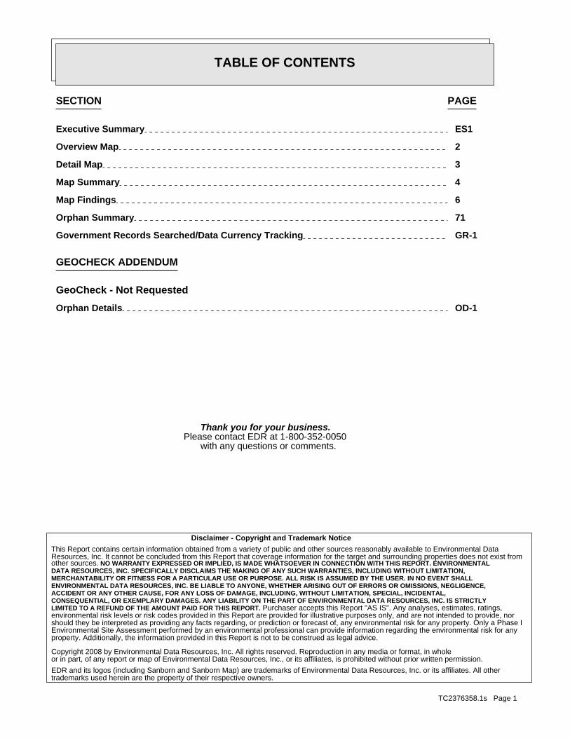
SECTION PAGE
Executive Summary ES1
Overview Map 2
Detail Map 3
Map Summary 4
Map Findings 6
Orphan Summary 71
Government Records Searched/Data Currency Tracking GR-1
GEOCHECK ADDENDUM
GeoCheck - Not Requested
Orphan Details OD-1
TC2376358.1s Page 1
Thank you for your business.Please contact EDR at 1-800-352-0050
with any questions or comments.
Disclaimer - Copyright and Trademark Notice
This Report contains certain information obtained from a variety of public and other sources reasonably available to Environmental DataResources, Inc. It cannot be concluded from this Report that coverage information for the target and surrounding properties does not exist fromother sources. NO WARRANTY EXPRESSED OR IMPLIED, IS MADE WHATSOEVER IN CONNECTION WITH THIS REPORT. ENVIRONMENTALDATA RESOURCES, INC. SPECIFICALLY DISCLAIMS THE MAKING OF ANY SUCH WARRANTIES, INCLUDING WITHOUT LIMITATION,MERCHANTABILITY OR FITNESS FOR A PARTICULAR USE OR PURPOSE. ALL RISK IS ASSUMED BY THE USER. IN NO EVENT SHALLENVIRONMENTAL DATA RESOURCES, INC. BE LIABLE TO ANYONE, WHETHER ARISING OUT OF ERRORS OR OMISSIONS, NEGLIGENCE,ACCIDENT OR ANY OTHER CAUSE, FOR ANY LOSS OF DAMAGE, INCLUDING, WITHOUT LIMITATION, SPECIAL, INCIDENTAL,CONSEQUENTIAL, OR EXEMPLARY DAMAGES. ANY LIABILITY ON THE PART OF ENVIRONMENTAL DATA RESOURCES, INC. IS STRICTLYLIMITED TO A REFUND OF THE AMOUNT PAID FOR THIS REPORT. Purchaser accepts this Report "AS IS". Any analyses, estimates, ratings,environmental risk levels or risk codes provided in this Report are provided for illustrative purposes only, and are not intended to provide, norshould they be interpreted as providing any facts regarding, or prediction or forecast of, any environmental risk for any property. Only a Phase IEnvironmental Site Assessment performed by an environmental professional can provide information regarding the environmental risk for anyproperty. Additionally, the information provided in this Report is not to be construed as legal advice.
Copyright 2008 by Environmental Data Resources, Inc. All rights reserved. Reproduction in any media or format, in wholeor in part, of any report or map of Environmental Data Resources, Inc., or its affiliates, is prohibited without prior written permission.
EDR and its logos (including Sanborn and Sanborn Map) are trademarks of Environmental Data Resources, Inc. or its affiliates. All othertrademarks used herein are the property of their respective owners.
TABLE OF CONTENTS
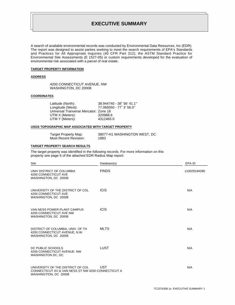
EXECUTIVE SUMMARY
TC2376358.1s EXECUTIVE SUMMARY 1
A search of available environmental records was conducted by Environmental Data Resources, Inc (EDR).The report was designed to assist parties seeking to meet the search requirements of EPA’s Standardsand Practices for All Appropriate Inquiries (40 CFR Part 312), the ASTM Standard Practice forEnvironmental Site Assessments (E 1527-05) or custom requirements developed for the evaluation ofenvironmental risk associated with a parcel of real estate.
TARGET PROPERTY INFORMATION
ADDRESS
4200 CONNECTICUT AVENUE, NWWASHINGTON, DC 20008
COORDINATES
38.944740 - 38˚ 56’ 41.1’’Latitude (North): 77.065550 - 77˚ 3’ 56.0’’Longitude (West): Zone 18Universal Tranverse Mercator: 320988.6UTM X (Meters): 4312465.0UTM Y (Meters):
USGS TOPOGRAPHIC MAP ASSOCIATED WITH TARGET PROPERTY
38077-H1 WASHINGTON WEST, DCTarget Property Map:1983Most Recent Revision:
TARGET PROPERTY SEARCH RESULTS
The target property was identified in the following records. For more information on thisproperty see page 6 of the attached EDR Radius Map report:
EPA IDDatabase(s)Site
UNIV DISTRICT OF COLUMBIA4200 CONNECTICUT AVEWASHINGTON, DC 20008
110029194280FINDS
UNIVERSITY OF THE DISTRICT OF COL4200 CONNECTICUT AVEWASHINGTON, DC 20008
N/AICIS
VAN NESS POWER PLANT CAMPUS4200 CONNECTICUT AVE NWWASHINGTON, DC 20008
N/AICIS
DISTRICT OF COLUMBIA, UNIV. OF TH4200 CONNECTICUT AVENUE, N.W.WASHINGTON, DC 20008
N/AMLTS
DC PUBLIC SCHOOLS4200 CONNECTICUT AVENUE. NWWASHINGTON DC, DC
N/ALUST
UNIVERSITY OF THE DISTRICT OF COLCONNECTICUT AV & VAN NESS ST NW 4200 CONNECTICUT AWASHINGTION, DC 20008
N/AUST
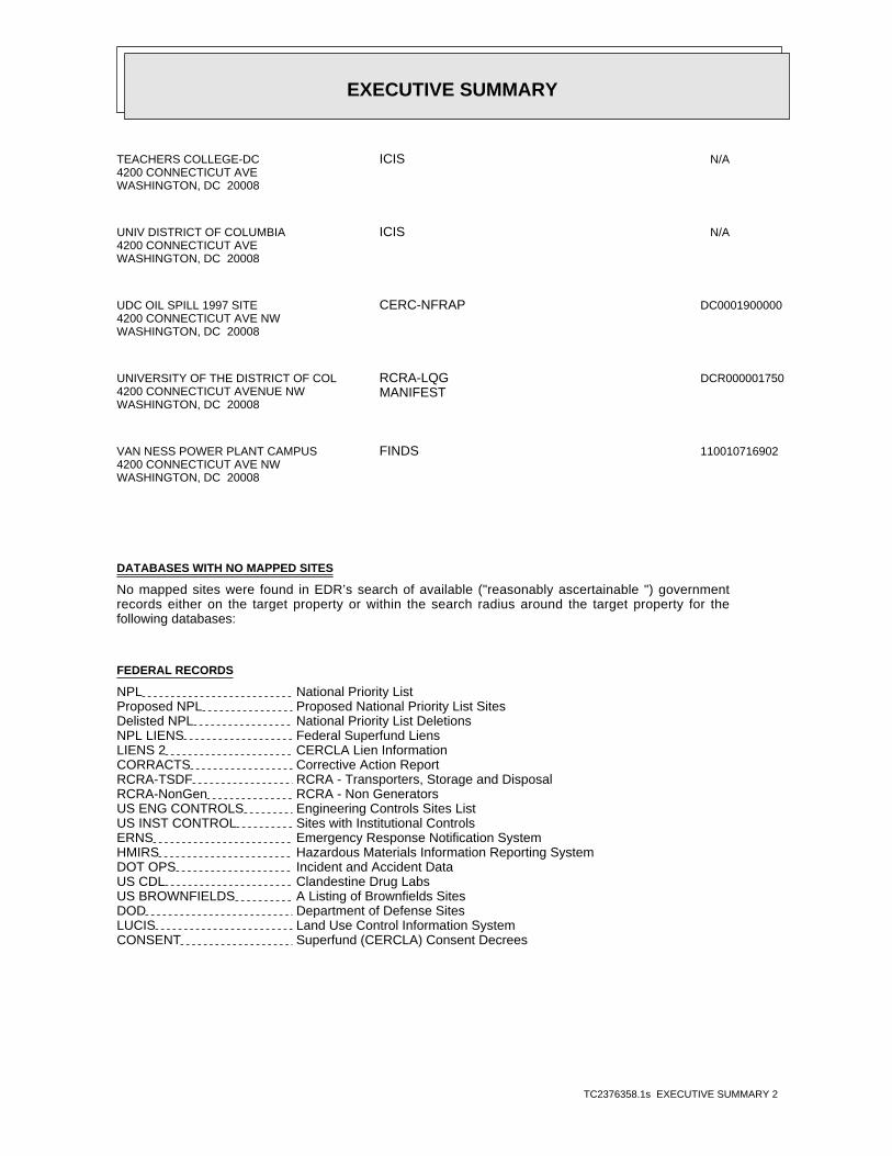
EXECUTIVE SUMMARY
TC2376358.1s EXECUTIVE SUMMARY 2
TEACHERS COLLEGE-DC4200 CONNECTICUT AVEWASHINGTON, DC 20008
N/AICIS
UNIV DISTRICT OF COLUMBIA4200 CONNECTICUT AVEWASHINGTON, DC 20008
N/AICIS
UDC OIL SPILL 1997 SITE4200 CONNECTICUT AVE NWWASHINGTON, DC 20008
DC0001900000CERC-NFRAP
UNIVERSITY OF THE DISTRICT OF COL4200 CONNECTICUT AVENUE NWWASHINGTON, DC 20008
DCR000001750RCRA-LQGMANIFEST
VAN NESS POWER PLANT CAMPUS4200 CONNECTICUT AVE NWWASHINGTON, DC 20008
110010716902FINDS
DATABASES WITH NO MAPPED SITES
No mapped sites were found in EDR’s search of available ("reasonably ascertainable ") governmentrecords either on the target property or within the search radius around the target property for thefollowing databases:
FEDERAL RECORDS
NPL National Priority ListProposed NPL Proposed National Priority List SitesDelisted NPL National Priority List DeletionsNPL LIENS Federal Superfund LiensLIENS 2 CERCLA Lien InformationCORRACTS Corrective Action ReportRCRA-TSDF RCRA - Transporters, Storage and DisposalRCRA-NonGen RCRA - Non GeneratorsUS ENG CONTROLS Engineering Controls Sites ListUS INST CONTROL Sites with Institutional ControlsERNS Emergency Response Notification SystemHMIRS Hazardous Materials Information Reporting SystemDOT OPS Incident and Accident DataUS CDL Clandestine Drug LabsUS BROWNFIELDS A Listing of Brownfields SitesDOD Department of Defense SitesLUCIS Land Use Control Information SystemCONSENT Superfund (CERCLA) Consent Decrees
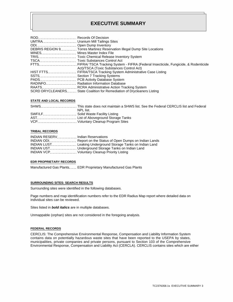
EXECUTIVE SUMMARY
TC2376358.1s EXECUTIVE SUMMARY 3
ROD Records Of DecisionUMTRA Uranium Mill Tailings SitesODI Open Dump InventoryDEBRIS REGION 9 Torres Martinez Reservation Illegal Dump Site LocationsMINES Mines Master Index FileTRIS Toxic Chemical Release Inventory SystemTSCA Toxic Substances Control ActFTTS FIFRA/ TSCA Tracking System - FIFRA (Federal Insecticide, Fungicide, & Rodenticide Act)/TSCA (Toxic Substances Control Act)HIST FTTS FIFRA/TSCA Tracking System Administrative Case ListingSSTS Section 7 Tracking SystemsPADS PCB Activity Database SystemRADINFO Radiation Information DatabaseRAATS RCRA Administrative Action Tracking SystemSCRD DRYCLEANERS State Coalition for Remediation of Drycleaners Listing
STATE AND LOCAL RECORDS
SHWS This state does not maintain a SHWS list. See the Federal CERCLIS list and Federal NPL list.SWF/LF Solid Waste Facility ListingAST List of Aboveground Storage TanksVCP Voluntary Cleanup Program Sites
TRIBAL RECORDS
INDIAN RESERV Indian ReservationsINDIAN ODI Report on the Status of Open Dumps on Indian LandsINDIAN LUST Leaking Underground Storage Tanks on Indian LandINDIAN UST Underground Storage Tanks on Indian LandINDIAN VCP Voluntary Cleanup Priority Listing
EDR PROPRIETARY RECORDS
Manufactured Gas Plants EDR Proprietary Manufactured Gas Plants
SURROUNDING SITES: SEARCH RESULTS
Surrounding sites were identified in the following databases.
Page numbers and map identification numbers refer to the EDR Radius Map report where detailed data onindividual sites can be reviewed.
Sites listed in bold italics are in multiple databases.
Unmappable (orphan) sites are not considered in the foregoing analysis.
FEDERAL RECORDS
CERCLIS: The Comprehensive Environmental Response, Compensation and Liability Information Systemcontains data on potentially hazardous waste sites that have been reported to the USEPA by states,municipalities, private companies and private persons, pursuant to Section 103 of the ComprehensiveEnvironmental Response, Compensation and Liability Act (CERCLA). CERCLIS contains sites which are either
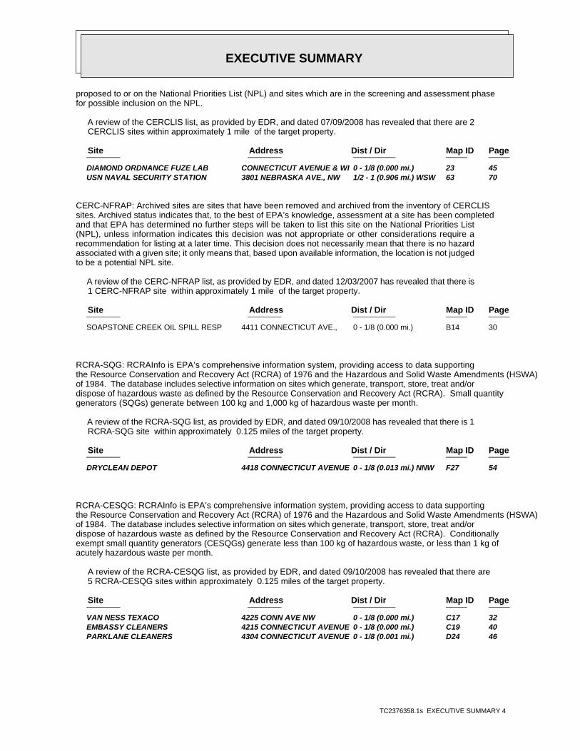
EXECUTIVE SUMMARY
TC2376358.1s EXECUTIVE SUMMARY 4
proposed to or on the National Priorities List (NPL) and sites which are in the screening and assessment phasefor possible inclusion on the NPL.
A review of the CERCLIS list, as provided by EDR, and dated 07/09/2008 has revealed that there are 2 CERCLIS sites within approximately 1 mile of the target property.
PageMap IDDist / Dir Address Site ________ ________ __________ _____ _____
DIAMOND ORDNANCE FUZE LAB CONNECTICUT AVENUE & WI 0 - 1/8 (0.000 mi.) 23 45 USN NAVAL SECURITY STATION 3801 NEBRASKA AVE., NW 1/2 - 1 (0.906 mi.) WSW 63 70
CERC-NFRAP: Archived sites are sites that have been removed and archived from the inventory of CERCLISsites. Archived status indicates that, to the best of EPA’s knowledge, assessment at a site has been completedand that EPA has determined no further steps will be taken to list this site on the National Priorities List(NPL), unless information indicates this decision was not appropriate or other considerations require arecommendation for listing at a later time. This decision does not necessarily mean that there is no hazardassociated with a given site; it only means that, based upon available information, the location is not judgedto be a potential NPL site.
A review of the CERC-NFRAP list, as provided by EDR, and dated 12/03/2007 has revealed that there is 1 CERC-NFRAP site within approximately 1 mile of the target property.
PageMap IDDist / Dir Address Site ________ ________ __________ _____ _____
SOAPSTONE CREEK OIL SPILL RESP 4411 CONNECTICUT AVE., 0 - 1/8 (0.000 mi.) B14 30
RCRA-SQG: RCRAInfo is EPA’s comprehensive information system, providing access to data supportingthe Resource Conservation and Recovery Act (RCRA) of 1976 and the Hazardous and Solid Waste Amendments (HSWA)of 1984. The database includes selective information on sites which generate, transport, store, treat and/ordispose of hazardous waste as defined by the Resource Conservation and Recovery Act (RCRA). Small quantitygenerators (SQGs) generate between 100 kg and 1,000 kg of hazardous waste per month.
A review of the RCRA-SQG list, as provided by EDR, and dated 09/10/2008 has revealed that there is 1 RCRA-SQG site within approximately 0.125 miles of the target property.
PageMap IDDist / Dir Address Site ________ ________ __________ _____ _____
DRYCLEAN DEPOT 4418 CONNECTICUT AVENUE 0 - 1/8 (0.013 mi.) NNW F27 54
RCRA-CESQG: RCRAInfo is EPA’s comprehensive information system, providing access to data supportingthe Resource Conservation and Recovery Act (RCRA) of 1976 and the Hazardous and Solid Waste Amendments (HSWA)of 1984. The database includes selective information on sites which generate, transport, store, treat and/ordispose of hazardous waste as defined by the Resource Conservation and Recovery Act (RCRA). Conditionallyexempt small quantity generators (CESQGs) generate less than 100 kg of hazardous waste, or less than 1 kg ofacutely hazardous waste per month.
A review of the RCRA-CESQG list, as provided by EDR, and dated 09/10/2008 has revealed that there are 5 RCRA-CESQG sites within approximately 0.125 miles of the target property.
PageMap IDDist / Dir Address Site ________ ________ __________ _____ _____
VAN NESS TEXACO 4225 CONN AVE NW 0 - 1/8 (0.000 mi.) C17 32 EMBASSY CLEANERS 4215 CONNECTICUT AVENUE 0 - 1/8 (0.000 mi.) C19 40 PARKLANE CLEANERS 4304 CONNECTICUT AVENUE 0 - 1/8 (0.001 mi.) D24 46
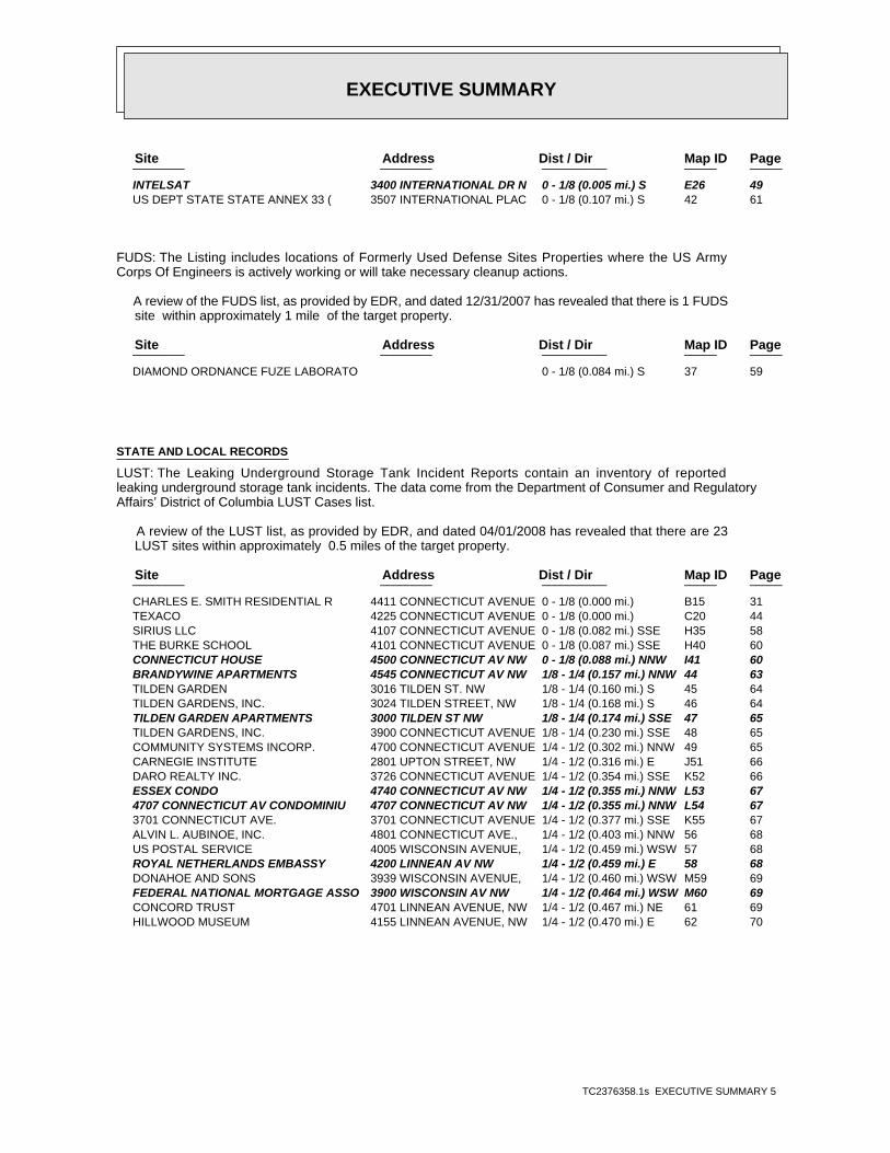
EXECUTIVE SUMMARY
TC2376358.1s EXECUTIVE SUMMARY 5
PageMap IDDist / Dir Address Site ________ ________ __________ _____ _____
INTELSAT 3400 INTERNATIONAL DR N 0 - 1/8 (0.005 mi.) S E26 49 US DEPT STATE STATE ANNEX 33 ( 3507 INTERNATIONAL PLAC 0 - 1/8 (0.107 mi.) S 42 61
FUDS: The Listing includes locations of Formerly Used Defense Sites Properties where the US ArmyCorps Of Engineers is actively working or will take necessary cleanup actions.
A review of the FUDS list, as provided by EDR, and dated 12/31/2007 has revealed that there is 1 FUDS site within approximately 1 mile of the target property.
PageMap IDDist / Dir Address Site ________ ________ __________ _____ _____
DIAMOND ORDNANCE FUZE LABORATO 0 - 1/8 (0.084 mi.) S 37 59
STATE AND LOCAL RECORDS
LUST: The Leaking Underground Storage Tank Incident Reports contain an inventory of reportedleaking underground storage tank incidents. The data come from the Department of Consumer and RegulatoryAffairs’ District of Columbia LUST Cases list.
A review of the LUST list, as provided by EDR, and dated 04/01/2008 has revealed that there are 23 LUST sites within approximately 0.5 miles of the target property.
PageMap IDDist / Dir Address Site ________ ________ __________ _____ _____
CHARLES E. SMITH RESIDENTIAL R 4411 CONNECTICUT AVENUE 0 - 1/8 (0.000 mi.) B15 31 TEXACO 4225 CONNECTICUT AVENUE 0 - 1/8 (0.000 mi.) C20 44 SIRIUS LLC 4107 CONNECTICUT AVENUE 0 - 1/8 (0.082 mi.) SSE H35 58 THE BURKE SCHOOL 4101 CONNECTICUT AVENUE 0 - 1/8 (0.087 mi.) SSE H40 60 CONNECTICUT HOUSE 4500 CONNECTICUT AV NW 0 - 1/8 (0.088 mi.) NNW I41 60 BRANDYWINE APARTMENTS 4545 CONNECTICUT AV NW 1/8 - 1/4 (0.157 mi.) NNW 44 63 TILDEN GARDEN 3016 TILDEN ST. NW 1/8 - 1/4 (0.160 mi.) S 45 64 TILDEN GARDENS, INC. 3024 TILDEN STREET, NW 1/8 - 1/4 (0.168 mi.) S 46 64 TILDEN GARDEN APARTMENTS 3000 TILDEN ST NW 1/8 - 1/4 (0.174 mi.) SSE 47 65 TILDEN GARDENS, INC. 3900 CONNECTICUT AVENUE 1/8 - 1/4 (0.230 mi.) SSE 48 65 COMMUNITY SYSTEMS INCORP. 4700 CONNECTICUT AVENUE 1/4 - 1/2 (0.302 mi.) NNW 49 65 CARNEGIE INSTITUTE 2801 UPTON STREET, NW 1/4 - 1/2 (0.316 mi.) E J51 66 DARO REALTY INC. 3726 CONNECTICUT AVENUE 1/4 - 1/2 (0.354 mi.) SSE K52 66 ESSEX CONDO 4740 CONNECTICUT AV NW 1/4 - 1/2 (0.355 mi.) NNW L53 67 4707 CONNECTICUT AV CONDOMINIU 4707 CONNECTICUT AV NW 1/4 - 1/2 (0.355 mi.) NNW L54 67 3701 CONNECTICUT AVE. 3701 CONNECTICUT AVENUE 1/4 - 1/2 (0.377 mi.) SSE K55 67 ALVIN L. AUBINOE, INC. 4801 CONNECTICUT AVE., 1/4 - 1/2 (0.403 mi.) NNW 56 68 US POSTAL SERVICE 4005 WISCONSIN AVENUE, 1/4 - 1/2 (0.459 mi.) WSW 57 68 ROYAL NETHERLANDS EMBASSY 4200 LINNEAN AV NW 1/4 - 1/2 (0.459 mi.) E 58 68 DONAHOE AND SONS 3939 WISCONSIN AVENUE, 1/4 - 1/2 (0.460 mi.) WSW M59 69 FEDERAL NATIONAL MORTGAGE ASSO 3900 WISCONSIN AV NW 1/4 - 1/2 (0.464 mi.) WSW M60 69 CONCORD TRUST 4701 LINNEAN AVENUE, NW 1/4 - 1/2 (0.467 mi.) NE 61 69 HILLWOOD MUSEUM 4155 LINNEAN AVENUE, NW 1/4 - 1/2 (0.470 mi.) E 62 70
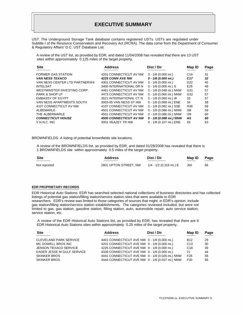
EXECUTIVE SUMMARY
TC2376358.1s EXECUTIVE SUMMARY 6
UST: The Underground Storage Tank database contains registered USTs. USTs are regulated underSubtitle I of the Resource Conservation and Recovery Act (RCRA). The data come from the Department of Consumer& Regulatory Affairs’ D.C. UST Database List.
A review of the UST list, as provided by EDR, and dated 11/04/2008 has revealed that there are 13 UST sites within approximately 0.125 miles of the target property.
PageMap IDDist / Dir Address Site ________ ________ __________ _____ _____
FORMER GAS STATION 4201 CONNECTICUT AV NW 0 - 1/8 (0.000 mi.) C16 31 VAN NESS TEXACO 4225 CONN AVE NW 0 - 1/8 (0.000 mi.) C17 32 VAN NESS CENTER LTD PARTNERSHI 4301 CONNECTICUT AV NW 0 - 1/8 (0.000 mi.) D22 45 INTELSAT 3400 INTERNATIONAL DR N 0 - 1/8 (0.005 mi.) S E25 49 WESTMINSTER INVESTING CORP. 4461 CONNECTICUT AV NW 0 - 1/8 (0.048 mi.) NNW G31 57 PARK & SHOP LP 4473 CONNECTICUT AV NW 0 - 1/8 (0.060 mi.) NNW G32 57 EMBASSY OF EGYPT 3521 INTERNATIONAL CT N 0 - 1/8 (0.060 mi.) W 33 57 VAN NESS APARTMENTS SOUTH 3003-05 VAN NESS ST NW 0 - 1/8 (0.069 mi.) ENE 34 58 4107 CONNECTICUT AV NW 4107 CONNECTICUT AV NW 0 - 1/8 (0.082 mi.) SSE H36 58 ALBEMARLE 4501 CONNECTICUT AV NW 0 - 1/8 (0.086 mi.) NNW I38 59 THE ALBERMARLE 4501 CONNECTICUT AV NW 0 - 1/8 (0.086 mi.) NNW I39 60 CONNECTICUT HOUSE 4500 CONNECTICUT AV NW 0 - 1/8 (0.088 mi.) NNW I41 60 V.N.N.C. INC 3001 VEAZEY TR NW 0 - 1/8 (0.107 mi.) ENE 43 63
BROWNFIELDS: A listing of potential brownfields site locations.
A review of the BROWNFIELDS list, as provided by EDR, and dated 01/28/2008 has revealed that there is 1 BROWNFIELDS site within approximately 0.5 miles of the target property.
PageMap IDDist / Dir Address Site ________ ________ __________ _____ _____
Not reported 2801 UPTON STREET, NW 1/4 - 1/2 (0.316 mi.) E J50 66
EDR PROPRIETARY RECORDS
EDR Historical Auto Stations: EDR has searched selected national collections of business directories and has collectedlistings of potential gas station/filling station/service station sites that were available to EDRresearchers. EDR’s review was limited to those categories of sources that might, in EDR’s opinion, includegas station/filling station/service station establishments. The categories reviewed included, but were notlimited to gas, gas station, gasoline station, filling station, auto, automobile repair, auto service station,service station, etc.
A review of the EDR Historical Auto Stations list, as provided by EDR, has revealed that there are 6 EDR Historical Auto Stations sites within approximately 0.25 miles of the target property.
PageMap IDDist / Dir Address Site ________ ________ __________ _____ _____
CLEVELAND PARK SERVICE 4401 CONNECTICUT AVE NW 0 - 1/8 (0.000 mi.) B12 29 MC DOWELL BROS INC 4201 CONNECTICUT AVE NW 0 - 1/8 (0.000 mi.) C13 30 JENSON TEXACO SERVICE 4225 CONNECTICUT AVE NW 0 - 1/8 (0.000 mi.) C18 39 EADER JESSE M GULF SERVICE 4339 CONNECTICUT AVE NW 0 - 1/8 (0.000 mi.) 21 44 SKINKER BROS 4441 CONNECTICUT AVE NW 0 - 1/8 (0.026 mi.) NNW F28 56 SKINKER BROS 4444 CONNECTICUT AVE NW 0 - 1/8 (0.037 mi.) NNW F30 56
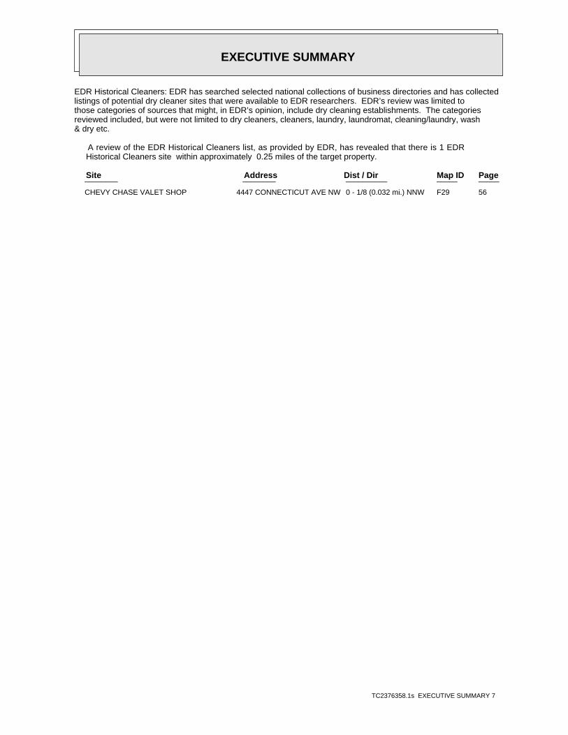
EXECUTIVE SUMMARY
TC2376358.1s EXECUTIVE SUMMARY 7
EDR Historical Cleaners: EDR has searched selected national collections of business directories and has collectedlistings of potential dry cleaner sites that were available to EDR researchers. EDR’s review was limited tothose categories of sources that might, in EDR’s opinion, include dry cleaning establishments. The categoriesreviewed included, but were not limited to dry cleaners, cleaners, laundry, laundromat, cleaning/laundry, wash& dry etc.
A review of the EDR Historical Cleaners list, as provided by EDR, has revealed that there is 1 EDR Historical Cleaners site within approximately 0.25 miles of the target property.
PageMap IDDist / Dir Address Site ________ ________ __________ _____ _____
CHEVY CHASE VALET SHOP 4447 CONNECTICUT AVE NW 0 - 1/8 (0.032 mi.) NNW F29 56
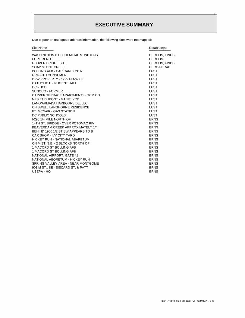
EXECUTIVE SUMMARY
TC2376358.1s EXECUTIVE SUMMARY 8
Due to poor or inadequate address information, the following sites were not mapped:
Site Name Database(s)____________ ____________
WASHINGTON D.C. CHEMICAL MUNITIONS CERCLIS, FINDSFORT RENO CERCLISGLOVER BRIDGE SITE CERCLIS, FINDSSOAP STONE CREEK CERC-NFRAPBOLLING AFB - CAR CARE CNTR LUSTGRIFFITH CONSUMER LUSTDPW PROPERTY - 1725 FENWICK LUSTCATHOLIC U - NUGENT HALL LUSTDC - HCD LUSTSUNOCO - FORMER LUSTCARVER TERRACE APARTMENTS - TCM CO LUSTNPS FT DUPONT - MAINT. YRD. LUSTLANO/ARMADA HARBOURSIDE, LLC LUSTCHISWELL LANGHORNE RESIDENCE LUSTFT. MCNAIR - GAS STATION LUSTDC PUBLIC SCHOOLS LUSTI-295 1/4 MILE NORTH OF ERNS14TH ST. BRIDGE - OVER POTOMAC RIV ERNSBEAVERDAM CREEK APPROXIMATELY 1/4 ERNSBEHIND 1900 1/2 ST SW APPEARS TO B ERNSCAR SHOP - IVY CITY YARD ERNSHICKEY RUN - NATIONAL ABARETUM ERNSON M ST. S.E. - 2 BLOCKS NORTH OF ERNS1 MACORD ST BOLLING AFB ERNS1 MACORD ST BOLLING AFB ERNSNATIONAL AIRPORT, GATE #1 ERNSNATIONAL ABORETUM - HICKEY RUN ERNSSPRING VALLEY AREA - NEAR MONTGOME ERNS901 M ST., SE - SISCARD ST. & PATT ERNSUSEPA - HQ ERNS
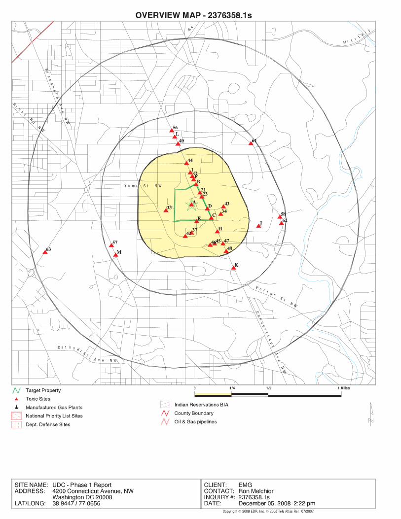
EDR Inc.EDR Inc.EDR Inc.EDR Inc.EDR Inc.EDR Inc.EDR Inc.EDR Inc.EDR Inc.EDR Inc.EDR Inc.EDR Inc.EDR Inc.EDR Inc.EDR Inc.EDR Inc.EDR Inc.EDR Inc.EDR Inc.EDR Inc.EDR Inc.EDR Inc.EDR Inc.EDR Inc.EDR Inc.EDR Inc.EDR Inc.EDR Inc.EDR Inc.EDR Inc.EDR Inc.EDR Inc.EDR Inc.EDR Inc.EDR Inc.EDR Inc.EDR Inc.EDR Inc.EDR Inc.EDR Inc.
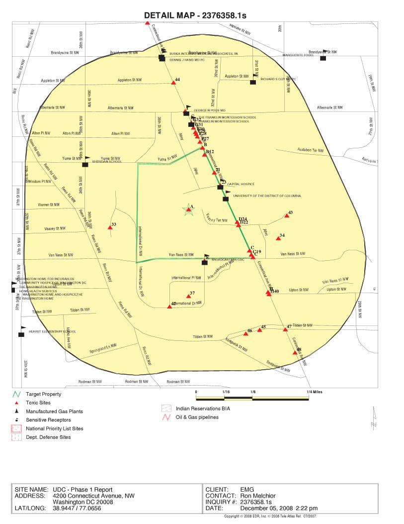
EDR Inc.EDR Inc.EDR Inc.EDR Inc.EDR Inc.EDR Inc.EDR Inc.EDR Inc.EDR Inc.EDR Inc.EDR Inc.EDR Inc.EDR Inc.EDR Inc.EDR Inc.EDR Inc.EDR Inc.EDR Inc.EDR Inc.EDR Inc.EDR Inc.EDR Inc.EDR Inc.EDR Inc.EDR Inc.EDR Inc.EDR Inc.EDR Inc.EDR Inc.EDR Inc.EDR Inc.EDR Inc.EDR Inc.EDR Inc.EDR Inc.EDR Inc.EDR Inc.EDR Inc.EDR Inc.EDR Inc.
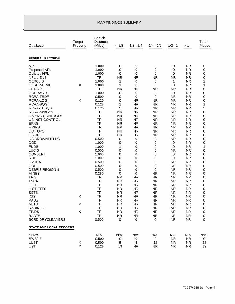
MAP FINDINGS SUMMARY
SearchTarget Distance Total
Database Property (Miles) < 1/8 1/8 - 1/4 1/4 - 1/2 1/2 - 1 > 1 Plotted
FEDERAL RECORDS
0 NR 0 0 0 0 1.000NPL 0 NR 0 0 0 0 1.000Proposed NPL 0 NR 0 0 0 0 1.000Delisted NPL 0 NR NR NR NR NR TPNPL LIENS 2 NR 1 0 0 1 1.000CERCLIS 1 NR 0 0 0 1 1.000 XCERC-NFRAP 0 NR NR NR NR NR TPLIENS 2 0 NR 0 0 0 0 1.000CORRACTS 0 NR NR 0 0 0 0.500RCRA-TSDF 0 NR NR NR NR 0 0.125 XRCRA-LQG 1 NR NR NR NR 1 0.125RCRA-SQG 5 NR NR NR NR 5 0.125RCRA-CESQG 0 NR NR NR NR NR TPRCRA-NonGen 0 NR NR NR NR NR TPUS ENG CONTROLS 0 NR NR NR NR NR TPUS INST CONTROL 0 NR NR NR NR NR TPERNS 0 NR NR NR NR NR TPHMIRS 0 NR NR NR NR NR TPDOT OPS 0 NR NR NR NR NR TPUS CDL 0 NR NR 0 0 0 0.500US BROWNFIELDS 0 NR 0 0 0 0 1.000DOD 1 NR 0 0 0 1 1.000FUDS 0 NR NR 0 0 0 0.500LUCIS 0 NR 0 0 0 0 1.000CONSENT 0 NR 0 0 0 0 1.000ROD 0 NR NR 0 0 0 0.500UMTRA 0 NR NR 0 0 0 0.500ODI 0 NR NR 0 0 0 0.500DEBRIS REGION 9 0 NR NR NR 0 0 0.250MINES 0 NR NR NR NR NR TPTRIS 0 NR NR NR NR NR TPTSCA 0 NR NR NR NR NR TPFTTS 0 NR NR NR NR NR TPHIST FTTS 0 NR NR NR NR NR TPSSTS 0 NR NR NR NR NR TP XICIS 0 NR NR NR NR NR TPPADS 0 NR NR NR NR NR TP XMLTS 0 NR NR NR NR NR TPRADINFO 0 NR NR NR NR NR TP XFINDS 0 NR NR NR NR NR TPRAATS 0 NR NR 0 0 0 0.500SCRD DRYCLEANERS
STATE AND LOCAL RECORDS
N/A N/A N/A N/A N/A N/A N/ASHWS 0 NR NR 0 0 0 0.500SWF/LF 23 NR NR 13 5 5 0.500 XLUST 13 NR NR NR NR 13 0.125 XUST
TC2376358.1s Page 4
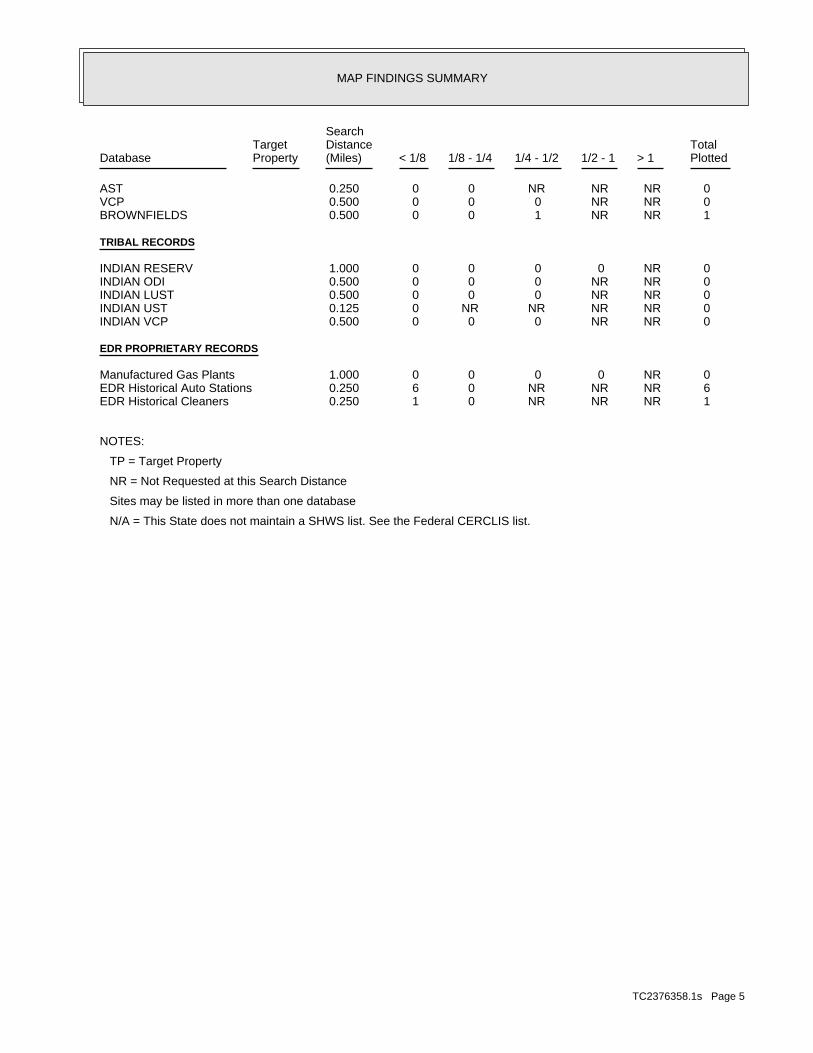
MAP FINDINGS SUMMARY
SearchTarget Distance Total
Database Property (Miles) < 1/8 1/8 - 1/4 1/4 - 1/2 1/2 - 1 > 1 Plotted
0 NR NR NR 0 0 0.250AST 0 NR NR 0 0 0 0.500VCP 1 NR NR 1 0 0 0.500BROWNFIELDS
TRIBAL RECORDS
0 NR 0 0 0 0 1.000INDIAN RESERV 0 NR NR 0 0 0 0.500INDIAN ODI 0 NR NR 0 0 0 0.500INDIAN LUST 0 NR NR NR NR 0 0.125INDIAN UST 0 NR NR 0 0 0 0.500INDIAN VCP
EDR PROPRIETARY RECORDS
0 NR 0 0 0 0 1.000Manufactured Gas Plants 6 NR NR NR 0 6 0.250EDR Historical Auto Stations 1 NR NR NR 0 1 0.250EDR Historical Cleaners
NOTES:
TP = Target Property
NR = Not Requested at this Search Distance
Sites may be listed in more than one database
N/A = This State does not maintain a SHWS list. See the Federal CERCLIS list.
TC2376358.1s Page 5
8899441199 .. 0088RR-- 000099 .. 001177
DUE DILIGENCE FOR THE LIFE CYCLE OF REAL ESTATE. 800.733.0660 • www.emgcorp.com
A S S E S S M E N T E N V I R O N M E N T A L
AA PP PP EE NN DD II XX GG :: SS UU PP PP OO RR TT II NN GG DD OO CC UU MM EE NN TT AA TT II OO NN
Monday, December 08, 2008.max
Monday, December 08, 2008.max
Monday, December 08, 2008.max