E A. Joneocean.org/download/db_files/profile_sarangani.pdf · GSC General Santos City GSTTEOI...
122
Transcript of E A. Joneocean.org/download/db_files/profile_sarangani.pdf · GSC General Santos City GSTTEOI...


i
Coastal Resource Management Project
of the
Department of Environment and Natural Resources
supported by the
United States Agency for International Development
2001
COASTAL ENVIRONMENTAL PROFILE
OF THE
SARANGANI BAY AREA
MINDANAO, PHILIPPINES
EDGAR A. DE JESUS
DOLORES ARIADNE D. DIAMANTE-FABUNAN
CLETO L. NAÑOLA
ALAN T. WHITE
HERMENEGILDO J. CABANGON

ii
Coastal Environmental Profile of the Sarangani Bay Area, Mindanao, Philippines
Edgar A. de Jesus, Dolores Ariadne D. Diamante-Fabunan, Cleto Nañola, Alan T. White and Hermenegildo J.Cabangon
2001PRINTED IN CEBU CITY, PHILIPPINES
Citation: de Jesus, E.A., D.A.D. Diamante-Fabunan, C. Nañola, A.T. White and H.J. Cabangon. 2001. CoastalEnvironmental Profile of the Sarangani Bay Area, Mindanao, Philippines. Coastal Resource Management Project,Cebu City, Philippines, 102 p.
This publication was made possible through support provided by the United States Agency for InternationalDevelopment (USAID) under the terms and conditions of Contract No. AID-492-C-00-96-00028-00 supportingthe Coastal Resource Management Project (CRMP). The opinions expressed herein are those of the authors anddo not necessarily reflect the views of the USAID. This publication may be reproduced or quoted in otherpublications as long as proper reference is made to the source.
Production: Ms. Leticia B. Dizon copy-edited and Lume Inamac and Leslie S. Tinapay word-processed, did thelayout, and designed the cover of this document.
Cover photos: A. T. White, H. J. Cabangon and T. ParrasInside photos: H. J. Cabangon and Olive Gonzales
CRMP Document No. 30-CRM/2001
ISBN 971-92289-7-0

iii
CONTENTS
Tables and FiguresAcronyms and AbbreviationsAcknowledgmentsForeword from the GovernorForeword from the MayorPrefaceCommonly Used Local TermsGlossary of Terms
Chapter 1Introduction
LocationShort Description of the AreaHistorical BackgroundSummary of IssuesObjectivesScope
Chapter 2Physical Features
Land AreaTopographyHydrologySoilLand UsesClimate
Chapter 3Natural Resources
Mineral ResourcesForest ResourcesCoastal Resources
Mangrove CommunitySeagrass CommunityCoral Reef and Reef Fish CommunitiesSeaweedsOther Marine Fauna
Summary
vviiiixxxixiixiiixv
1134456
999
12161618
21212122383941444445

iv
Chapter 4Sociopolitical Setting
Political/Administrative BoundariesDemography
Population Size, Density, and Growth RateHouseholdsAge and Gender CompositionUrban and Rural Population DistributionEducationLabor and EmploymentReligious and Ethnic GroupsDialects
Health, Sanitation, and Medical CareSettlementsRoads, Transportation and Communication, and RelatedInfrastructure or Support SystemsSummary
Chapter 5Economic Sector
FisheriesCapture FisheriesAquaculture
TourismIndustryAgricultureSummary
Chapter 6Institutional and Legal Framework
IntroductionCurrent State of the Philippine Coastal Zone LawLocal GovernmentNGOs Involved in Integrated Coastal ManagementCommunity OrganizationsSummary
Chapter 7Management Issues and Opportunities
Environmental Issues and OpportunitiesEconomic Issues and OpportunitiesPolitical and Institutional Issues and OpportunitiesSummary
References
4747475252535454565757585858
61
6363647577777980
81818284868688
8989929496
101

v
TABLES andFIGURES
Tables
2.1 Habitat land area per municipality in the Sarangani Bay profile area2.2 Slope classification of the coastal municipalities of Sarangani
Province and GSC2.3 List of watershed areas in Sarangani Province2.4 Characteristics of major watersheds2.5 Number of rivers and creeks per municipality in the profile area2.6 Water discharge levels of some rivers in Sarangani Province2.7 Results of the physicochemical studies of Sarangani Bay, 19972.8 Results of the biochemical studies of Sarangani Bay, 19972.9 Soil classification per coastal municipality of Sarangani Province
and GSC2.10 NIPAS and non-NIPAS protected lands per coastal municipality
of Sarangani Province2.11 Average temperature, rainfall, and relative humidity per month in
Sarangani Province3.1 Mineral deposits and other resources in the profile area3.2 Second growth forestlands of Sarangani Province3.3 Mangrove forestlands of the profile area3.4 List of mangrove species in Sarangani Bay3.5 List of seagrass species identified in the coastal areas of Sarangani
Province and GSC3.6 Percentage coral cover, substrate, and algae in the profile area3.7 Number of fish species, fish abundance, and biomass estimates in
Sarangani Province including GSC3.8 List of fish families and species observed4.1 Population size, density, and growth rate of the coastal
municipalities of Sarangani Province and GSC, 1990 and 19954.2 Population size and density of coastal barangays per municipality
of Sarangani Province and GSC4.3 Household size and number of households per municipality/city4.4 Age group breakdown per municipality/city, 19954.5 Urban and rural population breakdown, 1980 and 19904.6 Distribution of occupation in coastal barangays4.7 Percentage composition of house types and ownership in some
areas in the coastal municipalities of Sarangani Province5.1 Most common fishing methods used and frequency of use in the
profile area5.2 Number of times fishing methods are used in a week5.3 Fishing methods identified as either good or bad
1010
12121213141516
17
19
2222384040
4142
4352
53
5354555659
65
6666

vi
5.4 Fishing methods used by other members of the family5.5 Fishing methods used by various members of the fisher�s family5.6 Persons who accompany fishers during fishing5.7 Number of fishers and bancas based on household interviews from
the 5 municipalities of Sarangani Province5.8 Number of fishers and motorized and non-motorized boats per
coastal municipality of Sarangani Province and GSC5.9 Fishing effort of the common gear in the 5 municipalities of
Sarangani Province and GSC5.10 CPUE and IPUE per gear5.11 Fish species caught in the profile area and the number of
respondents in each municipality and city that identified thespecies accordingly
5.12 Weight of fish caught in 1 day in the profile area5.13 Distance from the shoreline where fishers catch their fish5.14 Monthly production from municipal fisheries in 19995.15 Number of bangus fry concessionaires and their annual harvest5.16 Monthly aquaculture production in 19995.17 List of tourist attractions in Sarangani Province and GSC5.18 Espina Industrial Center land use5.19 Livestock and poultry production per coastal municipality of
Sarangani Province, 1993-19946.1 1998 CRM budget for Malapatan6.2 List of academic and nongovernment organizations working on
integrated coastal zone management6.3 Past fishery NGO work in Sarangani, type of assistance offered, and
sources of funds
Figures
1.1 Map of Sarangani Bay2.1 Percent land area of each municipality compared to the total land
area of the profile area2.2 Percent of coastline per municipality/city compared to that of the
profile area2.3 Percent coastal land area per municipality/city in the profile area2.4 Profile area rivers and creeks2.5 One of the silted rivers in Maitum flowing into Sarangani Bay2.6 Locations of stations for the Sarangani Bay water quality sampling3.1 Map of Sarangani Province and GSC showing coastal resources
such as mangroves, seagrasses, and coral reefs3.2 Coastal resource map of Maitum, Sarangani Bay3.3 Coastal resource map of Kiamba, Sarangani Bay3.4 Costal resource map of Maasim, Sarangani Bay3.5 Coastal resource map of General Santos City, Sarangani Bay3.6 Coastal resource map of Alabel, Sarangani Bay3.7 Coastal resource map of Malapatan, Sarangani Bay3.8 Coastal resource map of Glan, Sarangani Bay
67676869
70
71
7172
7373747576787980
8486
87
211
11
1113141523
24262830323436

vii
3.9 Extensive beach of Barangay Salakit, Kiamba3.10 Natural growth mangroves in Malapatan-Maasim area3.11 Excellent cover of Acropora (branching corals) found in Tula Marine
Park, Kiamba3.12 Dugong washed on the shoreline of Sarangani Bay in Glan3.13 Newly hatched green turtles found in Lomuyon, Kiamba3.14 Change in living hard coral cover inside the Tuka Marine Sanctuary
from 1998 to 20013.15 Change in fish abundances (number of individuals within 500 m2
area) inside and outside of the Tuka Marine Sanctuary from 1998 to2001
4.1 Number of coastal and total barangays in the profile area4.2 Alabel coastal barangays4.3 GSC coastal barangays4.4 Glan coastal barangays4.5 Kiamba coastal barangays4.6 Maasim coastal barangays4.7 Maitum coastal barangays4.8 Malapatan coastal barangays4.9 Age-sex population pyramid, Sarangani, 19954.10 Highest education completed for GSC and Sarangani4.11 Household population 15 years old and over by trade skill,
Sarangani, 19954.12 Household population 15 years old and over by trade skill, GSC,
19954.13 Composition of religious groups in Sarangani Province4.14 Dialects spoken in Sarangani Province4.15 Part of the 178-km road network connecting GSC to the 10 major
municipalities5.1 Commercial fishing boats still fish in municipal waters of Sarangani
Bay5.2 Trend of catch per unit effort for small pelagic fisheries since 19485.3 Trends in Philippine fish production, 1987-19965.4 Number of hours spent by fishers catching fish5.5 Bamboo stakes where fisherfolk hang their torch to attract bangus
fry in Kiamba5.6 Fishponds near the pier in Glan6.1 Fish sanctuary established in Alabel by the DA and LGU6.2 Newly renovated patrol boat for Sarangani Province currently in
drydock in GSC7.1 Status of coral reef ecosystem in Sarangani Bay7.2 Project evaluators discussing the problem of limited entry with
residents of Sapu-Padidu, Glan7.3 Technical working group drawing the PCRA maps that identified
issues such as seajacking7.4 More marine sanctuaries are being established in the bay area
383942
444545
46
4848494950505151545556
56
575859
63
64656874
758486
9293
95
96

viii
BFAR Bureau of Fisheries and Aquatic ResourcesBIMP-EAGA Brunei, Indonesia, Malaysia, and Philippines-East ASEAN Growth
AreaCENRO Community Environment and Natural Resources OfficeCRM coastal resource managementCRMP Coastal Resource Management ProjectDA Department of AgricultureDENR Department of Environment and Natural ResourcesDILG Department of the Interior and Local GovernmentENRO Environment and Natural Resources OfficeFARMC Fisheries and Aquatic Resources Management CouncilGSC General Santos CityGSTTEOI General Santos Traders and Tuna Exporters OrganizationGT gross tonha hectarekm kilometerkm2 square kilometerLBII Louis Berger International, Inc.LGU local government unitlps liters per secondm metermg/L milligrams per literMGP Mindanao Growth Planml milliliterMPDO Municipal Planning and Development Officemt metric tonNGO nongovernment organizationNIPAS National Integrated Protected Areas SystemPAMB Protected Area Management BoardPCG Philippine Coast GuardPCRA Participatory Coastal Resource AssessmentPENRO Provincial Environment and Natural Resources OfficePNP Philippine National PoliceRA Republic ActSOCOPA South Cotabato Purse Seiners� AssociationSOCSKSARGEN South Cotabato-Sultan Kudarat-Sarangani-General Santos CitySUML Silliman University Marine Laboratoryt tonUSAID United States Agency for International DevelopmentUFLA Umbrella Fish Landing Association
ACRONYMS andABBREVIATIONS

ix
This profile could not have been possible without the help of a large number ofpeople. Their concern for the coastal environment was our inspiration in preparing this profile.The agencies listed below deserve special thanks for their valuable contribution:
The Municipal Agriculture and the Municipal Planning and Development Offices of:l Alabell Malapatanl Glan
ACKNOWLEDGMENTS
l Maasiml Kiambal Maitum
General Santos City Planning and Development Office (CPDO)General Santos City Agriculture OfficeGeneral Santos City Environment and Natural Resource OfficeProvincial Planning and Development OfficeProvincial Environment and Natural Resource OfficeProvincial Agriculture OfficeBureau of Fisheries and Aquatic Resources (BFAR)Department of Environment and Natural Resources (DENR) Regions XI and XIINational Statistics OfficeCommunity Extension and Research for Development, Inc.Canadian International Development AgencyLouis Berger International, Inc.Silliman UniversityMindano State University (MSU)Tambuyog Development CenterSouth Cotabato Foundation, Inc.Mahintana Foundation, Inc.
In particular we would like to thank the following persons for their special assistance:Hon. Priscilla L. Chiongbian, Governor, Sarangani ProvinceHon. Adelbert W. Antonino, Mayor, General Santos CityHon. Leoncio R. Caballero, Jr., Mayor, Glan, Sarangani ProvinceHon. Alfonso M. Singcoy, Mayor, Malapatan, Sarangani ProvinceHon. Narciso RA. Grafilo, Mayor, Alabel, Sarangani ProvinceHon. Moises A. Zamorro, Mayor, Maasim, Sarangani ProvinceHon. Raul C. Martinez, Mayor, Kiamba, Sarangani ProvinceHon. George Y. Yabes, Mayor, Maitum, Sarangani ProvinceMr. Giuseppe N. Chew, Provincial Director on CRM, Office of the Provincial Agriculturist
Sarangani ProvinceMs. Concepcion Portugal, Dean, College of Fisheries, Mindanao State UniversityMr. Ermine A. Achanzar, CEP Coordinator, DENRMs. Evelyn T. Deguit, Community Development Advisor, Coastal Resource Management ProjectMr. Olivia F. Gonzales, Technical Assistant, Coastal Resource Management Project, Sarangani ProvinceMr. Bayani Fredeluces, Technical Assistant, Coastal Resource Management Project, Sarangani
Province

x
As early as 1993, Sarangani Province had assumed the lead role as guardian andoverseer of Sarangani Bay. Sometime later, this was acknowledged or affirmed by GeneralSantos City, South Cotabato, and Sultan Kudarat by virtue of a gestured designation.
Since then, we have implemented various projects, some of which were carried outwith the valued assistance from the United States Agency for International Development(USAID) through the Coastal Resource Management Project (CRMP) of the Department ofEnvironment and Natural Resources (DENR).
The publication of the Coastal Environmental Profile of the Sarangani Bay Area willsurely help planners, project implementors, and our people as well to forge additional meansby which our coastal resources will be effectively managed for sustainable use.
Indeed, this is a welcome and very refreshing development as we move on in ourefforts in integrated coastal management. We now take hold of the updated informationregarding issues and concerns affecting the bay and this serves as an indispensable tool forfuture course of action.
It must have been a very straining experience for researchers to come up with thisprofile. The result is undeniably of tremendous significance�certainly of so much value to allof us whose lives are inevitably connected with the bay�s ecosystem.
To all the men and women responsible for the Sarangani Bay Profile, my sincereappreciation and heartfelt gratitude!
PRISCILLA L. CHIONGBIANGovernorSarangani Province
FOREWORDfrom the GOVERNOR

xi
Studies and research on the degradation of our coastal habitats and coral ecosystems reveal alarmingreports and figures. These statistics are instruments through which the ocean conveys its message. Our seas arecrying and we should listen intently to its anguish, or we will wake up one day and hear no more of its cries,because our seas will have dried up.
The Local Government of General Santos City has responded to this juncture with a positive note.Several marine protection programs have been instituted to ensure the sustainability of marine resources. This isthe city�s modest way of paying homage to the seas for the abundance it has offered. For example, regularfunding has been given to the Mangrove Rehabilitation Project in the three coastal barangays of the city:Barangays Bula, Baluan, and Buayan. The mangrove habitat has now broadened to 7 hectares. This project is incollaboration with the Coastal Resource Management Project, the Department of Environment and NaturalResources, Bayside Fishermen�s Association, and youth clubs from the city�s colleges.
Other important marine preservation programs include: the establishment of a fish sanctuary and marinereserve in Barangay Bawing which aims to regenerate fish stocks in the Sarangani Bay and the deputization offish wardens and the organization of Bantay Dagat, which are 2 surveillance and monitoring efforts to controlillegal fishing thereby properly implement fishery laws. These projects have been allocated regular funding fromthe city�s Local Development Fund.
I always emphasize the critical importance of a holistic management approach, by preserving andprotecting our natural resources, our marine ecosystem for that matter is the fundamental element. Sustainabledevelopment is about building a world we can bequeath to our children. The essence of the Sarangani Bay Profileis our regard for sustainability and survival.
If we are resolute in our environmental preservation and protection drive, let us by all means, giveconviction to this responsibility. Let us make our ocean breathe again. As Sarangani Province says, �Bring backthe fish, bring back the trees, bring back life.� Our sea is life itself. We have to co-exist with this life, otherwise,woe will be unto us.
Let this excerpt of a poem from a Burmese book spur hope and incite action:�Water is far from a simple commodity, water is a sociological complexity... water is life ...�
ADELBERT W. ANTONINOMayorGeneral Santos City
FOREWORDfrom the MAYOR

xii
The Coastal Environmental Profile of the Sarangani Bay Area, Mindanao, Philippinesprovides baseline information about the coastal environment of the Sarangani Bay Area andis intended to assist with management planning at the municipal and barangay levels withinthe Sarangani Bay Area. It can also serve as a guide for other coastal municipalities inSarangani and South Cotabato.
Coastal management problems identified in the Sarangani Bay Area are typical of fastdeveloping coastal areas. Most land areas have been converted to agriculture and fishponds,and very little of the coastal land retains natural vegetation. As a result, the bay suffers fromsedimentation. High fishing pressure has also been noted, and there are reports of the use oftoxic substance and fine mesh nets, as well as the catching of juvenile fishes in some areas.
The unique biodiversity values of its tropical rainforest and the marine environmentmake the protection of this integrated ecosystem an urgent task. The Sarangani Bay Area isone of the few areas where endangered marine mammals like the dugong (sea cow) andwhales are found. The bay is also lined with important coral reef and mangrove habitats thatadd tremendously to the natural productivity of the bay.
This profile is produced as part of the activities of the Coastal Resource ManagementProject (CRMP), implemented by the Department of Environment and Natural Resources(DENR), and funded by the United States Agency for International Development (USAID)which aims to develop and encourage leaders among local communities, nongovernmentorganizations (NGOs), and government units to work for coastal resource management (CRM).CRM is the process of planning, implementing, and monitoring beneficial and sustainableuses of coastal resources through participation, collaboration, and sound decision-making.This is reached by involving the entire affected community, resource users, local and regionalgovernment, NGOs, and the private sector. The aim is to promote an integrated coastalmanagement approach that focuses on sustainability in coastal resource use, and minimizingthe direct impacts on coastal resources from fishing, aquaculture, and tourism.
The integrated approach of participatory coastal management for the profile area hasproven successful in other areas of the Philippines, and in other Asian countries. This approachdepends on the dynamic action of community groups with local and national governmentagencies responsible for resource utilization in the area. This management approach doesnot dictate to the people, but rather, equips them, who rely the most upon the coastalenvironment, with the necessary tools to make rational and sustainable decisions. The firststep in this process is the development of baseline information for planning. This profilecompletes this step for the Sarangani Bay Area.
PREFACE

xiii
Local Terms English Translation
FISHING GEAR
Baling Beach seineBasnig Bag netBobo Fish trap or fish potBubo (pangnokos) Squid trapBunsod Fish corralHulbot-hulbot, Trawl
sinsuro, balingPahubas, lam-ba, Bottom set gill net
ta-an, pahanggaPalangre, pamirit, Multiple hook and line
undakPalaran, pokot, Gill net
patuloyPamante, pamangsi Drift gill netPamariles, pahawin, Long line
bira-biraPana, dimano, Spear gun
pusil-pusilPanonton, latak, Single hook and line
pasol, lagdong,patungkad,pahawin, pataw-pataw, palaran
Pukot Fine mesh netSadyap, sudsud Push netSikpam Scoop netSinsuro, likom Ring net
FISH
Abo Rockfish, scorpionfishAlibangbang ButterflyfishAluman EmperorAmag AnchovyAmag-amag Right-eye flounderAnduhaw MackerelAso-os WhitingAti PomfretBaga Soldier fishBaga-baga Squirrelfish
Local Terms English Translation
Bagis UnicornfishBagisan SurgeonfishBalaki GoatfishBangsi Flying fishBangus MilkfishBantol ScorpionfishBariles TunaBat-og SaurieBa-ulo JackBawak MulletBayang BatfishBilason FusilierBilong-bilong MoonfishBiyad TunaBokadolse ThreadfinBodboron TunaBodlotan ScorpionfishBolan TarponBolinao AnchovyBorot ScadBucao Scorpionfish, big-eyeBugaong Tigerperch, theraponBulan-bulan MoonfishBulao ScadBulgan Big-eyeCaraballas MackerelDalagang bukid FusilierDali SoleDanggit RabbitfishDapak PomfretDatu Big-eyeDayang PomfretDiwit Hairtail, scabbardfishDugho SwordfishGanting SquirrelfishGapas/gapas-gapas Monocle breamGisaw MulletHaan SnapperHaol HerringHaol-haol PilchardHasa-hasa MackerelHinok GoatfishHito Catfish
COMMONLY USEDLOCAL TERMS

xiv
Local Terms English Translation
Ibis GlassperchIlak RudderfishIndangan SurgeonfishIto CatfishKarao TunaKatambak Emperor, surf bream, snapperKawa-kawa WahooKitang/kikiro ScatKubal-kubal ScadLabayan Wrasse, rainbowfish, tamarinLagao Threadfin breamLangkoy HairtailLapis MackerelLapu-lapu Grouper, rockcod, seabassLawong ScorpionfishLatab MojarraLibgao AnchovyLiplipan Billfish, bailfishLipte Sweetlip, gruntLupoy HerringMalaguno ScadMalapati ScadMalmal ScadMamsa JackMarang MarlinMaya-maya SnapperMol-mol Parrotfish, wrasseMongit SurgeonfishMoong CardinalfishNaniw HalfbeakPakol TriggerfishPagi StingrayPalad Dusky solePalata LanternfishPandawan DolphinfishPata DamselfishPina EscolarPirit TunaPugot TriggerfishRolyete AmberjackRompe BarracudaSaging-saging GrouperSagisihon SnapperSagoksok Barracuda
Local Terms English Translation
Salanga Devil raySalingukod WhiptailSalmonSambagon TunaSapsap PonyfishSihag-sihag AnchovySihagan AnchovySilay Threadfin breamSolid FusilierSuwasid HalfbeakTabangko SillagoTalakitok Trevally, scadTamban Sardinella, herringTanguigue Mackerel, wahooTatabal-tabal SaddlegruntTilapiang-dagat TripletailTiki Lizardfish, snakefishTigi/tigi-tigi JobfishTurnos HerringTimbungan Goatfish, sweeperTugnos AnchovyTulay Scad, flying fishTulingan TunaUbod Moray eel, congerUna Mackerel
CRUSTACEANS
Banagan Spiny lobsterKasag CrabHipon ShrimpLambay CrabLokon PrawnUlang Shrimp
MOLLUSKS
Kubotan Octopus, cuttlefishKugita OctopusLabayan CuttlefishLumagayan Bigfin squidNokos SquidPusit SquidTabugok Octopus

xv
Beach seine. This net measures 50-200 m long x 1-5 m deep, with a mesh size of >3 cm. Four to 8 persons ina motorized or non-motorized banca use this at an average of 1 operation per day, 5 days per month. The fishingarea is 50-100 m from the shoreline at 10-20 fathoms. When a school of fish is detected, a banca lays out thenet to form a C facing the shore to half-enclose the fishes. Fishermen slowly pull the ends of the net on the shoreso that the fishes are driven into the bag (pocket). Upon reaching the shore, the fishes are picked from the bag.
Bottom set gill net. This gear uses nylon size #4, #6, #8, or #10 weaved into a net. The length may vary, but thedepth is often 1.5 m only. It is used in shallow waters close to shore, usually in mangrove, seagrass, and coralreef areas. Floats are attached to the top of the net and sinkers at the bottom so that the net stays open in thewater with the bottom touching the substrate. Its operation requires 1-2 people only. The net is left for anaverage of 3 hours after which it is hauled out of the water.
Crab or lobster trap. This is made up of bamboo or wire traps used to catch crabs or lobsters. Soaking time is afew days to a week.
Drift gill net. This is a long net line ranging from 200 to 16,000 m (16 km) long and 2-3 m deep that �drifts� inopen waters. The mesh size ranges from 4.5 to 10 cm made of filament size #4. This gear is used with a bigmotorized �motherboat� and 10 other smaller boats requiring 2-6 persons to operate.
Fine mesh net. This net is made of nylon (filament #4), with length ranging from 139 to 205 m, depth of 18-31m, and mesh size of 8 cm. Two people operate this gear.
Fish corral. The fish corral or fish pen is made of bamboo poles or brush set on the substrate in shallow waters(5-20 fathoms) to form a circle or square pen surrounded with nets. This is placed usually 20 m from the lowtideline, and shaped to direct the voluntary movement of fishes into the enclosure (Umali 1950). The opening to thecorral faces the shore. This requires 12-30 persons to build and ownership is often communal. When fishes haveaccumulated inside, these are harvested using some other gear type, usually gill or lift net.
Fishing with light. This is used to refer to any type of fishing done at night with the aid of a petromax (kerosene)lamp. The fishes are attracted to the light and gather around the fisher or the banca and then can be easilycaught with a spear gun or with a scoop net.
Fish trap or fish pot. This is a rectangular bamboo or wire trap used to catch demersal fishes. Soaking time is 1week.
Gill net. This net is made of a nylon, synthetic fiber or cotton twine #4, #7, #8, or #10. It measures 30-50 mlong and 1-2.5 m deep. The sinkers are light so that the net floats in mid-water following the current direction.One to 3 people are needed to operate this gear. This is left in place usually overnight for an average of 8 hoursin 3-28 fishing days.
Jigger. There are various modifications of this gear based on the bait used and target species caught. Thesaranggat is made up of a 30-m nylon line (size #4-12) and a bunch of stainless steel hooks (#1-24) arrangedwith the spikes directed outwards. The hooks are painted white in order to attract red squids (lumayagan) whichare its target (and only) species. Thus, these are also commonly called squid jiggers. Kati or hayungkong resemblesthe saranggat in appearance but uses for bait a black cloth and stones fashioned to resemble an octopus, acrustacean, or shrimp (kauongkong). This is often used at night with a light. The line is jerked up and down which
GLOSSARY of TERMS

xvi
attracts octopus and cuttlefish. As this gear is very specific, fishers may not be able to catch squids when theseare not in season.
Lift net. Like the scoop net, the lift net is also used together with other gear, usually the ring net and operatingfrom a boat. It is used to transport fishes encircled by the ring net, out of the water into the boat. This net is 4-100 m long and 5-27 m deep and has a small mesh size of 76 mm.
Long line. The pahawin is a long line measuring 200 m and is usually kept rolled around a bamboo tube. A large(size #13, #14, #15, or #17) baited hook is attached at the end of this line. A lead sinker attached to thesecondary line keeps the line at the bottom. This gear is towed at depths of 100-200 fathoms for 14-18 hours,usually from late afternoon up to early or mid-morning of the following day, by 1 to 2 persons on a motorizedboat.
The bira-bira is used in deep-sea fishing, often with the tuna handline because its target species, which are scads,are used for tuna bait. The long line is 100-300 m long, made of #130 or #160 nylon for the mainline, and #15nylon for the secondary line. A sinker and colored crystalet bait are attached before the secondary line. One ormore hooks size #15 or #19 are used. The line is suspended at depths of 100-200 fathoms, 1-5 km from theshoreline.
Multiple hand line. This is a single vertical line with a series of small barbed hooks attached to it by �spreaders�spaced at regular intervals.
Multiple hook and line. The undak is a line with 50-150 hooks attached 1 m from each other on the secondaryline, of any or a combination of the following hook sizes: #569, #572, or #571. The gear is towed at 20-30fathoms in pelagic waters. The palangre is a long filament line (thus may also be classified under long lines)measuring from 800 to 2,000 m and uses from 100 to 800 of hooks of any of the following sizes: #15, #565,#567, or #568. Bait is placed at every hook. This contraption is suspended near the bottom at depths of 3-5fathoms and is allowed to stay from 14 to 18 hours before it is brought in.
Pull or drag net. This net catches fish by horizontally pulling or dragging the gear.
Push net. The push net is a fine mesh net (similar to mosquito netting) used to catch bangus (Chanos chanos) fry.This is approximately 1 x 5 m, attached at both ends to a bamboo pole, and is pulled by 2 persons parallel to theshoreline. Another modification of the push net has dimensions of 10 m in length, 4 m in width, and 3 m in depth,and has a mesh size of 0.5 cm.
Rentex. This is a fishing line with bunch of colored fine threads at the end serving as bait. Two to 5 people slowlydrag this from a non-motorized boat. Belonid fishes are the target species of this gear type.
Ring net. This net combines the features of a round haul seine (which has a bunt at the center and is flanked by2 wings) and purse seine (Umali 1950). This is made of nylon of filament size #2-12 measuring 30-40 m long x2-16 m wide x 2-93 m deep, and has a mesh size of about 10 cm. The bottom of the net touches the substrateand may do damage when it scours the bottom as the net is hauled in. This gear is heavy, and its use requires amanpower of 9-14 persons. The ring net is used to encircle schools of pelagic fishes such as scads, mackerels,tunas, and sardines.
Scoop net. Scoop nets generally have a mesh size of 0.2 cm. Scoop nets are oftentimes used together with ringnets or gill nets to scoop out the fishes encircled by these gear or these may be used at night with a petromaxlantern that attracts fishes.

xvii
Seine net. This is a net with a bunt or bag, flanked at each side by quarters or wings. The gear is positioned asto encircle a shoal or school of fish and the catch is hauled toward the shore or a boat.
Set line. This is a long line oriented horizontally in midwater from which many hooks are suspended verticallyclose to the substrate. This gear is anchored to the bottom so it does not move with the current. The lengthvaries from 30 to 180 m and a hundred or more hooks are attached to it. This gear is specific for the belonid,Tylosorus acus melanotus.
Single hook and line. Gear with 1-5 hooks are classified under this gear type. There are variations of this gearbased on the hook number, the size, and weight of the sinker, and modifications in the appearance and use, whichare all geared towards catching specific species.
Pamariles or tuna handline is used in commercial fisheries, i.e., on fishing boats of more than 3 GT. The mainlineis made of #180 nylon to which a secondary line (#120 or 130) is attached. A sinker weighing 1 kg or more isattached before the secondary line. Smaller fishes, mostly scads, are used for bait. The line is 200-800 m longand is used in pelagic waters from 100 to 300 fathoms, 15 km from the shoreline. The catch includes tuna,Spanish mackerel, marlin, and sometimes dolphins.
In panglatak, a size #21 hook is used. Crystalet or cellophane strips (limbag) are used as bait for species such asmackerel, jacks, and other scombrids. This gear is used at depths of 30-50 fathoms.
The paniwit uses 1 to 2 hooks of sizes varying from #9 to #14 and #21, attached on a single nylon line #130 or#160 that is about 300-600 m long. A sinker (tulawog) weighing less than 1 kg is attached to a secondary lineof nylon #30. The target species are hairtails (Trichiurus spp).
Skylab. This is a relatively new device for fishing. It is made of a net, with 2-cm mesh size, attached at a steelring of 1.5-2 m diameter. Bait is made to settle on the substrate at the center of the net. When fishes concentrateat the center to feed on the bait, the net is pulled up quickly. One to 2 fishers are needed to operate the skylab.
Spear gun. There are 2 versions of this gear � the pana or spear gun and the diman or harpoon. The former isfashioned like a gun with rubber band or spring to trigger a sharpened 1-3 m long steel shaft. The latter is astraight steel rod with a 3-pronged end and is hurled toward the fish. Oftentimes, the spear gun is used in hookahor compressor fishing wherein a fisher breathes air from the surface through a long tube, thus permitting him tostay longer underwater.
Squid trap. This is a bamboo or wire trap fashioned into a square used specifically for catching squids. Mangrovebranches are laid in 5-7 fathoms of water for squids to lay their eggs on. These are then placed inside the trapin order to lure the squids. The soaking time is aproximately three weeks from the full moon to the last quarter.Trawl. This gear is used within 100 m from the shore and catches all species and all sizes of fish swept along itspath as it is dragged along the sea bottom. It also destroys seagrass and coral reef areas. The use of trawl withinthe bay is considered illegal.
Troll line. The local name for this gear is subid. A troll line is composed of a single hook (size #9 or #10) attachedto a 120-200 m nylon (filament size #50-160) with a sinker. It is pulled either by a motorized or non-motorizedbanca at 15-40 fathoms, often near fish shelters (payao).

xviii

1CHAPTER 1 INTRODUCTION
T
Chapter 1INTRODUCTION
LOCATION
he Sarangani Bay Learning Area of the Coastal Resource ManagementProject (CRMP) is composed of 6 municipalities and 1 chartered city.These are:l Alabell Glanl Kiambal Maasiml Maituml Malapatanl General Santos City
The area is located in southeastern Mindanao between 5°33�25�-6°6�15�Nand 124°22�45�-125°19�45�E. Figure 1.1 shows the location of the profile area.
General Santos City (GSC) divides the Sarangani Province municipalities, with3 municipalities on each side of the city. In this setup, GSC serves as the venue ofcommerce and trade of the surrounding municipalities, while Sarangani Province servesas the provider of agricultural products and manpower needs of the city. SaranganiProvince is composed of the municipalities of Alabel, Glan, Kiamba, Maasim, Maitum,Malapatan, and Malungon. However, the Municipality of Malungon is landlocked.GSC is a chartered city belonging to the First Congressional District of South Cotabato.
The area forms part of South Cotabato-Sultan Kudarat-Sarangani-General Santos(SOCSKSARGEN). SOCSKSARGEN is the name for the current development andeconomic support package provided by the national government and foreign assistance

2
Figure 1.1. Map of Sarangani Bay.
SaranganiBay

3CHAPTER 1 INTRODUCTION
groups. The area was identified as an alternative regional growth center based on itseconomic potential. In 1988, the United States Agency for International Development(USAID) undertook the funding and commitment to develop the area. Over the years,USAID has given over US$200 million. Aside from this, the area also forms part of theBrunei, Indonesia, Malaysia, and Philippines-East ASEAN Growth Area (BIMP-EAGA).GSC is the nearest Philippine city to BIMP-EAGA, and is being eyed to serve as a hubfor various investors entering the BIMP-EAGA market.
SHORT DESCRIPTION OF THE AREAThe entire profile area, with the exception of GSC, is mostly agricultural land. Eachmunicipality has its own product. The most dominant crops produced are banana,coconut, corn, and rice. Aside from agricultural land crops, the area is the center oftuna fishing industry in the country. The newly built fish port situated at Tambler, GSCfurther improves the handling and transport of fishery products for domestic andinternational needs.
The coastal areas of the province and city have varied features. Some areashave clean and nice beaches particularly those towards the mouth of Sarangani Bay.Others are fringed with mangrove and coral reefs and some areas have a rocky shoreline.The coastal waters are oceanic in origin, clear and warm.
The whole area has fair weather condition throughout the year. There are novery distinct dry and wet seasons. Rainfall is fairly evenly distributed throughout theyear with slightly more rainfall during the southeast monsoon (June to September).The area is safe from typhoons. It is situated near a dormant volcano (Mt. Matutum).
The economy of the profile area, particularly GSC, is growing very rapidly.Trade and investment will continue to grow due to the various infrastructureimprovements that have taken place. By 1994, the commitment for infrastructureprojects in GSC stood at PhP4 billion. Exports in the area increased by 80 percent injust 4 years (from US$110 million in 1990 to US$198 million in 1994). Since 1996,export value has reached US$228 million. Primary exports include canned tuna, coconutoil, pineapple products, asparagus, bananas, shrimp, copra pellets, frozen and freshtuna and other fish, and cut flowers.
GSC accounts for the second largest total daily fish landings in the country. Itis the leading producer of sashimi grade tuna. This is because of a major tuna migrationcorridor in the Celebes Sea that has helped the city in its development as a fishprocessing and exporting center.
Due to the increase in development in the area, the population is also growingmore rapidly than the national average. Details are discussed in Chapter 4.

4
HISTORICAL BACKGROUNDSarangani Province dates back to the turn of the 15th century when Sarip Kabungsuanof Arabia arrived in Cotabato to introduce Islam. In 1914, the first batch of Christianssettled in Glan and peacefully intermingled with the ethnic inhabitants of the province.In 1920, the first Ilocanos reached Kiamba. Between 1914 and 1934, settlers fromLuzon and the Visayas began to open the vast lands in the area. Sarangani Provincewas initially part of South Cotabato, until 1992 when Republic Act (RA) 7228 createdthe Province of Sarangani. The name Sarangani is derived from a legendary sailor andwarrior who lived in an island near the bay. According to legends, he frequently sailedacross the bay to the Sultanate of Buayan, a stronghold of the Maguindanaos. Hisfriendship and courage earned the respect of the Maguindanaos so they named thebay after him.
GSC and Sarangani Province have historical similarities primarily because theyare in the same area. In 1939, General Paulino Santos, Sr. led 62 settlers under theNational Land Settlement Administration�s Social Justice Program for Filipino Farmersinto the shores of Sarangani Bay. In 1948, RA 82 created the Municipality of Buayan.Six years later, in 1954, the Municipality of Buayan was renamed General Santosthrough RA 1107. On 8 July 1968, the Municipality of General Santos was convertedto General Santos City through RA 5412.
Coastal resource management (CRM) in the area is still in its early stages. TheMindanao Growth Plan (MGP) identified the important coastal resources in the areaand determined the main causes of depletion. In 1993, MGP completed a CoastalArea Management Framework Plan for Sarangani Province and GSC. The planemphasized the active participation of local officials and the community in order toprotect and conserve the resources of the bay. CRMP has built on this framework planto prepare a comprehensive CRM plan.
Present data reveal that nearly half of the dipterocarp forest has been damagedor converted into agricultural land. In addition, more than half of the coral reef areahas been damaged due to destructive fishing practices. Based on Department ofEnvironment and Natural Resources (DENR) reports, more than half of the presentmangrove forest has been damaged or converted into fishponds.
SUMMARY OF ISSUESThe issues related to integrated coastal management confronting the profile area canbe categorized into 3 major issues:
l Environmental quality issuesl Resource exploitation issuesl Legal, institutional, and administrative issues

5CHAPTER 1 INTRODUCTION
Sarangani and GSC have been targeted for rapid development. With developmentcomes accompanying problems. Part of the environmental quality issue and one of themajor problems is sedimentation. According to persons interviewed, this mainly comesfrom the upland areas and is due to destructive agricultural practices, illegal logging,and mining operations. This is further discussed in Chapters 2 and 7.
Another issue affecting the area is pollution from domestic wastes. Most coastalhouseholds do not have proper waste disposal systems. This contributes to the pollutionin the bay. Another issue is industrial pollution. Fish canneries in GSC have been asource of complaint from residents. Pollution management appraisals conducted in1993 and 1994 have also shown that most of the fish canneries do not have adequatewastewater treatment systems. DENR analysis has shown that discharges from thesefacilities do not meet the government standards for Sarangani Bay. These issues arediscussed further in Chapter 7.
A major issue concerning resource exploitation is the encroachment ofcommercial fishers in municipal waters. This issue has legal and jurisdictional aspects.Various agencies at the national and local government level are joining hands to solvethis problem. Other issues involving resource exploitation include destruction of coralreefs and mangroves, illegal fishing (such as the use of fine mesh nets and dynamiteand cyanide), and overfishing.
Although Sarangani Bay was proclaimed as a protected seascape, thereby makingit a part of the National Integrated Protected Areas System (NIPAS) of DENR, thereseems to be little change in the current management of the bay. This is the main legal,institutional, and administrative issue. Currently, DENR has general administration ofSarangani Bay, but the coastal users believe that DENR is not focusing enough attentionon Sarangani Bay as a protected seascape. They point to the fact that the ProtectedArea Management Board (PAMB) has been very unwieldy as a management group,because of the large number of members. In most cases, the PAMB has not been ableto form a quorum.
As in most parts of the Philippines, enforcement of laws is very weak. SaranganiProvince and GSC are no exception. In some cases, apprehension has been successful,but the prosecution of the offender is a problem. Details of all the issues are discussedin Chapter 7.
OBJECTIVESThe compilation of this profile for Sarangani is one of the steps taken by CRMP in theformulation of a CRM plan. The profile provides detailed background information andbaseline data on Sarangani Bay and the local government units (LGUs) in the profilearea. It provides broad information on the physical features, natural resources,

6
sociopolitical affairs, the local economy, laws and legal framework related to coastalresources and environment, and the prevailing issues and opportunities.
Information was based on various sources, primarily from secondary publishedand unpublished literature, including the Participatory Coastal Resource Assessments(PCRA), as well as interviews with key players in CRM in Sarangani Bay.
The specific objectives are to:l Provide baseline information on the Sarangani Bay profile area;l Determine actual and current conditions of coastal resources in Sarangani
Bay;l Educate readers about the need for CRM in Sarangani Bay and motivate
them to take part in CRM;l Identify additional studies needed or information not currently available,
and the next steps that need to be taken;l Identify the present issues and problems in CRM;l Determine the present coastal management programs being undertaken by
the province, the coastal municipalities, and the city.
SCOPEThe scope of this profile includes the 6 coastal municipalities of Sarangani Province(Alabel, Glan, Kiamba, Maasim, Maitum, and Malapatan) and GSC.
The physical features of the area are discussed in Chapter 2 and these includeinformation on land area, topography, hydrology, soil, land uses, and climate. Thenatural resources are discussed in Chapter 3 and include mineral resources, forestresources, and coastal resources. Coastal resources are discussed in detail includingmangroves, seagrass, corals, seaweeds, fisheries, beaches, and endangered species.
The sociopolitical setting is discussed in Chapter 4. It includes information onthe political and administrative boundaries in the profile area, on the area�s demography,and growth rate. It also includes age and gender composition, education, labor andemployment, income, religion and ethnic groups, dialects, health, sanitation and medicalcare, settlements (type and ownership), roads, transportation and communication,and other related infrastructure or support systems. When data on coastal areas arelacking, provincial or municipal data are used instead.
Chapter 5 discusses the economy and focuses on coastal-related issues. Topicsinclude fisheries, tourism, industries, agriculture, and forestry. Information on theseindustries includes the types and location, number of employees, revenues generated,and its social, cultural, and environmental impact.

7CHAPTER 1 INTRODUCTION
The institutional and legal framework is discussed in Chapter 6. This includesthe current state of the Philippine coastal zone laws. It also discusses the structure ofthe LGUs down to the barangay level. Details of development plans, activities, andprojects related to fisheries and other coastal resources are included. Information onthe funding for these projects, as well as the budget allocated for coastal activities isalso provided.
Chapter 7 discusses management issues and opportunities broken down intoenvironmental, economic, and political and institutional categories.
MAITUM FACTS AND FIGURESBarangays (19): Bati-an, Kalaneg, Kalaong, Kiambing,
Kiayap, Mabay, Maguling, Malag(Pob.), Mindupok, New La Union, OldPoblacion (Maitum), Pangi (Linao),Pinol, Sison (Edenton), Ticulab,Tuanadatu, Upo (Lanao), Wali(Kambuhan), Zion
Coastal Barangays (7): Kalaong, Kiambing, Mabay,Maguling, Mindupok, Old Poblacion(Maitum), Pinol
Total Land Area: 324.4 km2
Coastal Land Area: 66.9 km2
Length of Coastline: 25 km
Total Population: 3 5 , 0 0 9
Population of Coastal Barangays: 1 5 , 4 7 2
KIAMBA FACTS AND FIGURESBarangays (18): Badtasan, Datu Dani, Gasi, Kapate,
Katubao, Kayupo, Ling (Lumit),Lagundi, Lebe, Lomuyon, Luma,Maligang, Nalus, Poblacion, Salakit,Suli, Tablao, Tamadang, Tambilil
Coastal Barangays (13): Datu Dani, Katubao, Kayupo,Ling (Lumit), Lagundi, Lebe,Lomuyon, Luma, Nalus, Poblacion,Salakit, Suli, Tambilil
Total Land Area: 418.2 km2
Coastal Land Area: 262.6 km2
Length of Coastline: 39.6 km
Total Population: 3 9 , 7 1 7
Population of Coastal Barangays: 3 2 , 2 1 7
ALABEL FACTS AND FIGURESBarangays (12): Alegria, Bagacay, Baluntay, Datal
Anggas, Domolok, Kawas, Maribulan,Pag-Asa, Paraiso, Poblacion (Alabel),Spring, Tokawal
Coastal Barangays (3): Kawas, Maribulan, Poblacion( A l a b e l )
Total Land Area: 540.5 km2
Coastal Land Area: 42.1 km2
Length of Coastline: 12.1 km
Total Population: 4 6 , 5 2 7
Population of Coastal Barangays: 2 1 , 6 3 9
MALAPATAN FACTS AND FIGURESBarangays (12): Daan Suyan, Kihan, Kinam, Libi, Lun
Masla, Lun Padidu, Patag, Poblacion(Malapatan), Sapu Masla, SapuPadidu, Tuyan, Upper Suyan
Coastal Barangays (6): Lun Masla, Lun Padidu,Poblacion (Malapatan), Sapu Masla,Sapu Padidu, Tuyan
Total Land Area: 840.0 km2
Coastal Land Area: 463.8 km2
Length of Coastline: 15.3 km
Total Population: 4 7 , 9 1 1
Population of Coastal Barangays: 3 0 , 7 4 7

8
MAASIM FACTS AND FIGURESBarangays (16): Amsipit, Bales, Colon, Daliao,
Kabatiol, Kablacan, Kamanga,Kanalo, Lumasal, Lumatil, Malbang,Nomoh, Pananag, Poblacion(Maasim), Seven Hills, Tinoto
Coastal Barangays (12): Colon, Daliao, Kabatiol,Kablacan, Kamanga, Kanalo,Lumasal, Lumatil, Malbang, Pananag,Poblacion (Maasim), Tinoto
Total Land Area: 724.4 km2
Coastal Land Area: 376.2 km2
Length of Coastline: 43.1 km
Total Population: 3 1 , 6 4 1
Population of Coastal Barangays: 2 7 , 0 0 0
GSC FACTS AND FIGURESBarangays (26): Baluan, Buayan, Bula, Conel,
Dadiangas East (Pob.), Katangawan,Lagao, Labangal, Ligaya, Mabuhay,San Isidro, San Jose, Sinawal,Tambler, Tinagacan, Apopong, Siguel,Upper Labay, Batomelong,Calumpang, City Heights, DadiangasNorth, Dadiangas South, DadiangasWest, Fatima, Olympog
Coastal Barangays (13): Baluan, Buayan, Bula,Calumpang, Labangal, DadiangasSouth, Dadiangas West, Tambler,S i g u e l
Total Land Area: 536.1 km2
Coastal Land Area: 150.9 km2
Length of Coastline: 27 km
Total Population: 3 7 7 , 0 3 4
Population of Coastal Barangays: 1 7 2 , 9 6 5
GLAN FACTS AND FIGURESBarangays (29): Baliton, Batotuling, Batulaki, Big
Margus, Burias, Cablalan, Calabanit,Calpidong, Congan, Cross,Datalbukay, E. Alegado, Glan Padidu,Gumasa, Kapatan, Lago, Laguimit,Mudan, New Aklan, Pangyan,Poblacion, Rio del Pilar, San Jose,San Vicente, Small Margus,Sufatubo, Taluya, Tango, Tapon
Coastal Barangays (12): Baliton, Batulaki, Big Margus,Burias, Cablalan, Glan Padidu,Gumasa, Kapatan, Lago, Pangyan,Poblacion, San Jose, Small Margus,Taluya, Tango, Tapon
Total Land Area: 651.5 km2
Coastal Land Area: 220.0 km2
Length of Coastline: 64.3 km
Total Population: 7 3 , 7 6 8
Population of Coastal Barangays: 4 5 , 8 1 0

9CHAPTER 2 PHYSICAL FEATURES
Chapter 2PHYSICAL FEATURES
tLAND AREA
he Sarangani Bay Learning Area is composed of municipalities inSarangani Province and GSC. Sarangani Province is composed of 7municipalities: Alabel, Glan, Kiamba, Maasim, Maitum, Malapatan andMalungon. All are coastal municipalities except for Malungon. Theprofile area has a total land area of 4,035.10 km2 and a coastline of226.4 km from Pinol Point in Maitum to Tinaca Point in Glan(Table 2.1).
Among the 7 coastal areas mentioned, Malapatan has the largest land areacovering 840 km2 (Figure 2.1), 55 percent of which forms the coastal barangays.However, Malapatan also has the second shortest coastline. Glan has the longestcoastline at 64.3 km, while Alabel has the shortest coastline at 12.1 km (Figure 2.2).Alabel also has the smallest coastal land area at 8 percent of the total (Figure 2.3).
TOPOGRAPHYThe topographic characteristic of the profile area is from rolling to steep slope. This isdue to the presence of mountain ranges found along the land borders of the area.They are Alip Range to the east and Daguma Range, Mt. Parker, and Mt. Matutum tothe north. However, none of the peaks of these mountains is within the politicalboundary of the province and the city. The highest mountain peak, Mt. Busa, situatedwithin the province is about 2,083 m above sea level. Mt. Matutum, with an elevationof 2,286 m, is situated in the adjacent province, South Cotabato.

10
Table 2.2. Slope classification of the coastal municipalities of Sarangani Province and GSC. All values are in km2.
Data from the City Planning and Development Office 1990; Municipal Planning and Development Office 1993; and Provincial Planning andDevelopment Office 1994
Table 2.1. Habitat land area per municipality in the Sarangani Bay profile area.
The lowland or flat areas with slope ranging from 0 to 8 percent are concentratednear the coast. The widest flat areas are situated in GSC (50 percent of the total landarea), Alabel (24 percent), and Maitum (23 percent). Kiamba (17 percent) and Maasim(18 percent) have relatively narrow flat areas. Glan (6 percent) and Malapatan (5percent) have the narrowest flat areas (Table 2.2).
Data from the Participatory Coastal Resource Assessment 1998
Habitats (ha)Sandy beachRocky shorelineInshore flatSeagrass bedsCoral reefEstuaryMangroveLand area (ha)
Terrestrial(incl. islands)(excl. islands)
MarineLength of shoreline (m)
(incl. islands)(excl. islands)
Alabel GeneralSantos
Glan Kiamba Maasim Maitum Malapatan
4223
74334
427
45,2152,831
10,803
47051
105284
6837
62,05416,122
30,159
1,438187297615669173118
59,89172,329
66,167
890
263459274
96
46,50749,782
36,546
444145153
96437
88152
40,15859,131
44,893
328137
149300186
29,01929,01835,842
24,50624,243
99784350
1102549
64,5478,797
18,426
68.38
7.30
69.82
32.35
139.48
7.92
325.25
Slope classification(percent)
0 to 3Nearly level to level
3.1 to 73.1 to 8
Nearly level to undulating7.1 to 158.1 to 158.1 to 18
Undulating to rolling15.1 to 2515.1 to 3018.1 to 30
Rolling25.1 to 5030.1 to 4530.1 to 50
Rolling to steep45.1>50.1>
Steep to very steepTotal
Alabel Glan Kiamba Maasim Maitum Malapatan GSC
98.56
32.00
80.64
20.48
68.43
240.34
540.45
33.15
11.56
105.38
248.58
234.32
64.62
697.61
59.14
13.56
56.32
114.24
84.96
9.76
338.28
50.71
79.69
137.64
181.11
202.84
72.44
724.43
46.08
68.48
57.60
185.60
482.24
840.00
190.30
78.80
151.17
71.30
44.49
536.06

11CHAPTER 2 PHYSICAL FEATURES
Figure 2.1. Percent land area of each municipality compared to thetotal land area of the profile area.
Figure 2.2. Percent of coastline per municipality/city compared tothat of the profile area.
Figure 2.3. Percent coastal land area per municipality/city in theprofile area.
Maitum8%
Kiamba10%
Alabel13%
General Santos City13%Glan
16%
Maasim18%
Malapatan22%
Glan29%
Maasim19% Kiamba
17%
GeneralSantosCity12%
Maitum11%
Malapatan7%
Alabel5%
Malapatan28%
Maasim24%
Kiamba17%
Glan14%
General Santos City10%
Maitum4%
Alabel3%

12
HYDROLOGYThere are about 6 watershed areas identifiedin the profile area. The largest watershedarea is found in Kiamba covering 4 barangayswith a total area of 172 km2. Themunicipalities of Glan and Malapatan eachhave 2 watershed areas with a combinedarea of 87 and 105 km2, respectively (Table2.3).
Twenty-five percent of the total water consumption of SOCSKSARGEN is suppliedby Mt. Matutum. Aside from the 6 watersheds, there are 4 major watersheds whichare headwaters and catchments for several important rivers including Silway, Klinan,and Buayan-Malungon which empty into Sarangani Bay through GSC; and Alabel andTaplan-Marbel Rivers which flow to Lake Buluan (Table 2.4). Most of the tributaries of
Silway, Klinan, and Buayan Rivers arecontributing large amounts ofsuspended sediment due to severeerosion caused by improperagricultural land uses in the uplandareas and deforestation of Mt.Matutum.
There are about 51 rivers and19 creeks (those that are not dry
during dry season) present in the entire area. These rivers include Kraang River, KalaongRiver, Siguel River, Buayan-Malungon River, Lun Padidu, Lun Masla, and Glan River.The longest river is Lun Masla River found in Malapatan with a total length of 129 km.The rest of the rivers have lengths of less than 70 km. There are 3 rivers with lengthsbetween 50 and 70 km, 12 rivers with lengths between 20 and 50 km and 28 riverswith lengths less than 20 km (Figures 2.4 and 2.5, Table 2.5).
On the other hand, thelongest creek is Amsikong found inAlabel. It has a total length of 20km. The rest of the creeks havelengths less than 15 km.
In terms of the waterdischarge levels of these rivers, veryfew have available information. Dataare available for only 14 rivers out
Table 2.3. List of watershed areas in Sarangani Province.
Data from the Provincial Environment and Natural Resources Office(1997)
Watershed area Location Area (km2)
Kling-Nalus-Tual-SuagenLun Masla-SuyanLun Padidu-Tuyan-MalapatanMargus GrandeNew La Union BarangayGlan-Malteo
KiambaMalapatanMalapatanGlanMaitumGlan
172.0823.2782.0821.000.70
66.56
Table 2.4. Characteristics of major watersheds.
ND = no data
River Drainagearea (km2)
BuayanKlinanSilwayTaplan
Length(km)
Length ofcatchment
(km)
Averagebasin slope(degree)
1,049.30114.98424.18
63.40
612739ND
39.0015.0021.0016.90
0.040.08
16.000.38
Table 2.5. Number of rivers and creeks per municipality in the profilearea.
Note: The creeks listed include only those that are not dry during dry season.ND = no data
Municipality/City
No. ofrivers
AlabelGlanKiambaMaasamMaitumMalapatanGSC
Lengthrange(km)
No. ofcreeks
Length range(km)
19
137876
625-508-29
13-2711-37
11-129ND
9ND
21133
4-62ND
14-208
ND8-14
ND

13CHAPTER 2 PHYSICAL FEATURES
Figure 2.4. Profile area rivers and creeks.
of 51. The rivers with the largest discharge are Pangi River (12,603 liters per second(lps)) in Malapatan, Domolok River (10,213 lps) in Alabel, and Kalaong I River (8,820lps) in Maitum. The rest of the rivers have discharge levels of less than 6,000 lps (Table2.6).
The Industrial Environmental ManagementProject (IEMP) conducted physical, chemical, andbiological studies of Sarangani Bay and some ofthe rivers that drain into the bay in 1997. Table2.7 shows the analytical results of the samplestaken from the bay and Figure 2.6 shows thelocations of the stations where the samples weretaken.
This means that the water is not potabledue to the high level of fecal contamination andheavy silt load deposits. Studies by IEMP (1997)and MGP (LBII 1993) showed elevatedconcentrations of metals particularly cadmium,copper, and lead.
Source: LBII (1993)
Table 2.6. Water discharge levels of some riversin Sarangani Province.
River River length(km)
Dischargelevels (lps)
DomolokBalitonGlan PadiduGlanBadtasanKlingTambililTualKalaongKiayapLuanPangiUpoSaub
ND11.2516.0050.5012.00
ND15.7512.7527.00
ND16.0021.0015.5011.25
10,213411503
3,5161,1333,2051,624
9608,820
1311,066
12,603730
1,017
6.6
6.5
6.4
6.3
6.2
6.1
6.0
5.9
5.8
5.7
5.6
5.5
124.2 124.3 124.4 124.5 124.6 124.7 124.8 124.9 125.2 125.3 125.4 125.5 125.6 125.7 125.8125.1125.0
Province of
South Cotabato
Province of
Davao del Sur
Gen. Santos City
Malungon
Alabel
Malapatan
Glan
to JoseAbad Santos
to D
avao
Tinaca Pt.
to Koronadal
Kiamba
Maasim
MaitumPinol Pt.
toSultanKudarat
Legend
municipality/city boundaryroad networkriver/creek
East longitude
Nort
h latitu
de

14
Results also showed a highconcentration of suspended solids thatare mostly attributed to the tributariesdraining into Sarangani Bay. Thesuspended solids come from uplandactivities such as logging, mining, andlivestock raising.
Sarangani Bay has an area ofabout 449 km2, extending fromTampuan Point in Maasim to SumbangPoint in Glan. The length of coastlinebetween these points is about 79 km.The average depth is 350 m. This,coupled with its wide opening and the
low discharge rates of rivers, make Sarangani waters strongly oceanic in salinity.Consequently, the strong density difference between waters of the bay and riverineinput inhibits mixing of the 2, leading to the formation of a surface plume whichpersists in the absence of wind mixing. The absence of wind mixing reduces verticalmixing and the possible dilution of pollutants. Tide generated currents are generallyweak, except near the mouth of the bay and are incapable of moving materials morethan 1 km. Strong wind-generated currents run along the coast in narrow bands,
Table 2.7. Results of the physicochemical studies of Sarangani Bay, 1997.
* Damaged- No applicable standard.Values enclosed in parentheses are maximum valuesValues in italics do not conform with Class SA standards
** Sampling stations are found in Figure 2.6
Source: IEMP (1997)
Samplingstation**
Temperature(oC)
Conductivity(mS/cm)
Turbidity(NTO)
TSS(mg/L)
TDS(mg/L)
Oil andgrease(mg/L)
pH DO(mg/L)
123456789101112131415
28.929.329.329.529.428.928.729.129.028.728.929.029.028.730.0
46.045.745.945.745.845.645.546.145.946.246.146.445.845.645.9
000
0.152.69.76.19.01.10.9
013.12.42.8
0
36.052.044.038.0163.030.042.040.040.050.056.036.027.029.032.0
49.034.440.556.547.458.039.260.854.543.455.555.853.354.652.7
1.06.06.06.03.05.04.03.06.02.0
*5.03.04.03.0
8.18.08.18.18.18.08.18.18.18.18.18.18.18.18.0
2.83.32.92.33.93.62.62.42.62.93.11.63.42.41.8
Stdused
Results Stdused
Results Stdused
Results Stdused
Results Stdused
Results Stdused
Results Stdused
Results
BOD(mg/L)
Stdused
Results Stdused
Results
ClassSC
ClassSC
ClassSC
ClassSC
ClassSC
ClassSC
ClassSC
ClassSC
ClassSC
6.66.07.05.95.96.26.26.26.26.36.36.15.96.26.7
Average ofresults
3oCrise
29.1 45.9
-
6.5
-
47.7
<30%rise
50.4
-
4.1
3
8.1
6.5-8.5
6.2
5.5
2.8
7 (10)
SA - marine waters suitable for the propagation, survival, and harvesting of shellfish for commercial purposes; touristzones, national marine parks and reserves; and coral reef parks and reserves designated by law
SB - marine waters suitable for recreational water Class 1 or areas regularly used by the public for bathing, swimming,skin diving, etc.; and fishery water Class 1 or spawning areas for Chanos chanos and similar species
SC - marine waters suitable for recreation water Class 2 or bathing; fishery water Class 2 or commercial and sustenancefishing; and marshes and mangrove areas declared as fish and wildlife sanctuaries
SD - marine waters suitable for industrial water supply Class 2, e.g., cooling and other coastl and marine waters
Figure 2.5. One of the silted rivers in Maitum flowing intoSarangani Bay.

15CHAPTER 2 PHYSICAL FEATURES
SINAWAL RIVERSILWAY RIVER
GENERALSANTOS CITY
BUAYAN RIVER
4 3 2
51
6
LUN-MASLARIVER
SIGUEL RIVER
10
11
12
13
14
15
SUMBANG PT.
126 0�Eo
126 10�Eo
126 20�Eo
5 48�No
6 0�No
6 8�No
GLAN RIVER
SCALE: 1:200,000
SAMPLING STATIONS:TRIBUTARIES
SARANGANI BAY
TAMPUAN PT.
7
8
9
SARANGANI BAY
Figure 2.6. Locations of stations for the Sarangani Bay water quality sampling.
Table 2.8. Results of the biochemical studies of Sarangani Bay, 1997.
* Not present in concentration to affect fish flavor/taste** Sampling bottle was not accepted at the UP Public Health- Not applicable standard-- No analysisSource: IEMP (1997)
Samplingstation
Phenol(mg/L)
Lead(mg/L)
Cadmium(mg/L)
Copper(mg/L)
Mercury(mg/L)
TotalColiform
(MPN/100 ml)
FecalColiform
(MPN/100 ml)
Pesticide
123456789101112131415
ndndndndndnd
0.0010.001
ndndndndndnd
<0.01
141017004100
*7000
*******
7600-
12000
>16>16>16
**>16
**************
>16--
>16
Stdused
Results Stdused
Results Stdused
Results Stdused
Results Stdused
Results Stdused
Results Stdused
Results Stdused
Results
ClassSC
ClassSC
ClassSC
ClassSC
ClassSC
ClassSC
ClassSC
ClassSC
ndndndndndndndndndndndndndndnd
Average ofresults
-
0.004 0.614
0.05
0.049
0.01
0.104
0.05
0.001
0.002
5640
5000
>16
-
nd
nd
<0.
<0.0.
<0.<0.
0.0.0.
<0.0.0.0.
-001---001002001001006007004001002003003
0.
0.0.0.0.0.0.0.0.0.0.0.0.
622-665515622644665601601644579622601601
0.
0.0.0.0.0.0.0.0.0.0.0.0.
043--0460390315104303303903903905604304
0.
0.0.0.0.0.0.0.0.0.0.0.0.
107--107085086107107107107107107107107107
nil Extremely low concentration and not detectable by existingequipment
nd Not detectedValues in italics are not conforming with Class SA standards

16
increasing interactions among marine ecological communities. Unfortunately, this alsomakes entrainment of pollutants along the coast more likely, increasing the vulnerabilityof coastal habitats and aquaculture activities.
Oil and grease seem to be the most common pollutant as almost all stations inthe IEMP (1997) study show concentrations ranging from 1 to 6 mg/L. Oil and greasecome mostly from shipping activities and from the fish canneries in GSC.
In 1997, the Silliman University Marine Laboratory (SUML) took samples inSarangani Bay to analyze total coliform. All stations showed positive results. It isassumed that household waste is the major source since most households in the areado not have any toilets nor any proper wastewater drainage. Animal manure andgarbage are also thrown into the sea or left unattended along the shore. Anotherpossible cause of the high total coliform is the piggeries upstream that are brought tothe bay via the river systems.
SOILTable 2.9 shows the soil classification of the province and the city. About 29.49percent of the land area is classified as clay loam, 11.22 percent as loam, 6.26 percentas silty clay loam, 7.52 percent as sandy loam, 29 percent as mountain clay soil,23.78 percent as undifferentiated soil, and 0.44 percent as fine sandy loam. Amongthe soil types mentioned, clay loam soil type is the best suited for agricultural purposesbecause of its ability to release the water it holds for plant use.
Table 2.9. Soil classification per coastal municipality of Sarangani Province and GSC. All values are in km2.
Data from the City Planning and Development Office 1990 and Provincial Planning and Development Office 1994
Soil typeLoamSandy loamFine sandy loamSilty clay loamClay loamMountain clay soilUndifferentiated soilTotal
125.1433.92
164.48
216.96540.50
23.00
96.00578.60
697.60
Alabel Glan Kiamba Maasim
62.74
234.24121.30418.28
Maitum
579.55144.88724.43
Malapatan GSC
96.79227.56
324.35
232.73
17.92
101.76
487.59840.00
100.00250.00
131.0055.00
536.00
LAND USESFrom the total land area of 4,081 km2, 1,522 km2 (37 percent) are classified as alienableand disposable (A&D) land while 2,558 km2 (63 percent) are classified as forestland.
Furthermore, from the combined forestland of the province amounting to 2,304km2 (2,558 km2 less GSC�s 254 km2), 741 km2 (29 percent) are classified as protectionforest and 764 km2 (30 percent) as production forest. In 1997, a greater proportion of

17CHAPTER 2 PHYSICAL FEATURES
the production forest was utilized for agricultural purposes, according to the ProvincialPlanning and Development Office (PPDO).
The province�s A&D land is distributed as follows:l 54 km2 as irrigated rice land or fishponds;l 345 km2 as land for cultivated annual crops (such as corn, upland rice,
pineapple, cotton, vegetables, sorghum, and others);l 372 km2 as land for perennial trees (such as fruit trees and coconut) and
vine crops;l 468 km2 as pasture land (such as cows, horses, goats, and cattle); andl 48 km2 as builtup areas.
GSC does not have any protection forest. Most of the forestlands are beingutilized for agricultural purposes. Furthermore, a large proportion of its A&D land isbeing utilized as builtup, agriculture, and pasture lands. There are areas in SaranganiProvince that fall within the NIPAS. These are the areas that need to be protected andmanaged to maintain the natural biological and physical diversities of the environmentnotably areas with biologically unique features to sustain human life and development.
The province has a total of 741.91 km2 of protected forestland. Of this, only48.5 km2 are within the NIPAS under Proclamation No. 147 and only 12.9 km2 (26percent) are within the coastal municipality. This is the Mt. Balabak Forest Reserve inKiamba (12.9 km2). The other protected area is Mt. Matutum Protected Landscapefound in Malungon (35.6 km2).
Aside from landscape protection, NIPAS also includes aquatic areas. The wholearea of Sarangani Bay and the adjoining municipal waters of Maasim, Kiamba, andMaitum was declared as Protected Seascape by President Fidel V. Ramos on 5 March1996 under Proclamation No. 756. It covers a total water area of 345 km2.
In addition to the protected forestand seascape areas covered by the NIPAS,the provincial government of Sarangani hasidentified areas that limit the expansion ofsettlements for environmentalconsiderations. These include secondgrowth forest, mangrove forest, fishsanctuaries, and critical watershed areas(Table 2.10). The following is a moredetailed listing of areas that have beenconsidered for protection.
Table 2.10. NIPAS and non-NIPAS protected landsper coastal municipality of Sarangani Province.
Data from the Provincial Planning and Development Office 1997
Municipality NIPAS (km2) Non-NIPAS(km2)
AlabelGlanKiambaMaasimMaitumMalapatanMalungonTotal
0.000.00
12.900.000.000.00
35.6048.50
215.5087.56
172.0857.87
117.36105.35111.00866.72

18
l National parks;l Watershed reserves;l Wildlife preserves and sanctuaries;l Aesthetic potential tourist spots;l Habitat for any endangered or threatened species of indigenous Philippine
wildlife (flora and fauna);l Areas of unique historic and archaeological or scientific interest;l Areas traditionally occupied by cultural communities or tribes;l Areas frequently visited or hard hit by natural calamities (geological hazards,
flood, typhoon, volcanic activity, and others);l Areas with critical slopes;l Prime agricultural lands;l Recharge areas of aquifers;l Water bodies which may be tapped for domestic purposes or within the
controlled and/or protected areas declared by appropriate authorities orwhich support wildlife or fishery activities;
l Mangrove areas with primary pristine and dense young growth or adjoiningmouth of river system or near or adjacent to traditional productive fry orfishing grounds or which act as national buffers against shore erosion,strong winds, storm floods, and others; and
l Coral reef with 50 percent and above coral cover or spawning and nurserygrounds for fish or act as a natural breakwater for the coastline.
CLIMATEThe prevailing wind direction in the area is the northeast monsoon from the months ofNovember to March and the southwest monsoon from the months of June to October.There is no distinct dry and wet season observed for the area. Rainfall is evenlydistributed throughout the year. The annual average rainfall for 1996 is 1,184 mm and626 mm in 1997. The low annual average rainfall in 1997 was attributed to the El Niñophenomenon. The average temperature is around 27°C. Relative humidity is around78 percent. Compared to 1996, it was expected that annual rainfall would increase in1998 because of the La Niña phenomenon. Table 2.11 presents the meteorologicaldata for Sarangani Province.

19CHAPTER 2 PHYSICAL FEATURES
Data from the Philippine Atmospheric, Geophysical, and Astronomical Services Administration of General SantosCity 1996 and 1997
Table 2.11. Average temperature, rainfall, and relative humidity per month in Sarangani Province.
Month
JanuaryFebruaryMarchAprilMayJuneJulyAugustSeptemberOctoberNovemberDecember
26.327.127.128.527.727.526.827.427.527.727.527.5
Averagetemperature (oC)
Relative humidity(percent)
1996 1997
Averagerainfall (mm)
27.026.927.928.628.427.727.127.827.427.128.528.1
1996 1997 1996 199785.788.837.574.7
116.896.1
176.675.0
150.3159.9
52.870.0
85.642.449.850.344.772.793.134.246.716.726.273.9
83.078.074.079.083.076.082.081.082.082.082.079.0
79.080.076.077.079.081.084.081.082.080.078.076.0

20

21CHAPTER 3 NATURAL RESOURCES
MINERAL RESOURCES
arangani Province and GSC have rich metallic and non-metallic mineraldeposits. The metallic minerals include copper, gold, and iron; the non-metallic minerals include cement lime, coal, gypsum, limestone,phosphate rock, and silica. Most non-metallic minerals are of commercialquantities particularly the cement lime, limestone, and silica. However,none of them is tapped for exploration purposes. Other resources foundin the area include the guano, sand stone, and white pebbles (Table3.1).
Sarangani Province has strongly objected to applications for exploration permitsof all mining corporations filed with the Mines and Geosciences Bureau (MGB). However,mining activities in neighboring South Cotabato may impact Sarangani Bay due tothe sedimentation caused by mining operations.
FOREST RESOURCESThe province has a dipterocarp forest in all of its coastal municipalities except Maasim.Based on land classification, it covers an area of 2,304.23 km2. Of the total forestlandarea, 33 percent (753.91 km2) is considered as secondary growth forest. These areashave been logged or disturbed for some time and were able to recover. In terms oftotal forest and secondary forestland proportions, Maitum is the largest (71 percent),followed by Kiamba (60 percent), and Alabel (50 percent). However, in terms of totalsecondary forestland, Alabel is the highest (28 percent), followed by Kiamba (22percent) (Table 3.2). However, destructive agricultural practices and illegal loggingthreaten these forest resources.
Chapter 3NATURAL RESOURCES
s

22
Once forest cover is depleted,erosion results. This contributes tothe sedimentation of the coastalarea especially areas near the rivermouth. In order to stop this,Sarangani Province is formulatingthe Provincial Forest Land Use Plan.This will serve as a framework toattain the province�s long-term visionof sustainable development and well-managed resources.
As part of improving forest cover, DENR has distributed 1 million forest andornamental seedlings from 1994 to 1997 for reforestation purposes. The AsianDevelopment Bank (ADB) has also funded the implementation of the ForestryReforestation and Community Approach Reforestation Schemes. Under this project,DENR has replanted 1,613 ha of forestland (Chiongbian 1998).
The first LGU-led community-based forest management (CBFM) project is inSarangani. The project area covers 32,000 ha of timberland in Kiamba and Maitum.This is the first CBFM project in the Philippines initiated and generally supervised byLGUs.
COASTAL RESOURCESSarangani Province and GSC have a total coastline of 226.4 km (Figure 3.1). Figures3.2 to 3.8 show the coastal resource maps of the municipalities and city in theSarangani Bay Learning Area. The figures also present the uses of different areas intheir jurisdiction as well as major issues involved for each area. Resources that can be
Table 3.1. Mineral deposits and other resources in the profile area.
Data from the Provincial Environment and Natural Resources Office and Provincial Planning and Development Office 1994
Table 3.2. Second growth forestlands of SaranganiProvince.
Data from the Provincial Planning and Development Office 1997
Municipality Second growthforest (km2)
Percentcomposition
AlabelGlanKiambaMaasimMaitumMalapatanTotal
215.2787.02
172.0857.66
117.26104.62753.91
28.611.522.8
7.615.613.9
100.00
Municipality/City
AlabelGlan
KiambaMaasim
MaitumMalapatan
GSC
Metallic Non-metallic Other resources
Copper, gold
Iron, copper, goldCopper, gold, silica
Copper, gold, iron
Copper, iron, gold silver
Phosphate rock,limestone, coal
Gypsum, limestone,cement lime, silica
Phosphate rock,limestone, coal, silicaLimestone, sulfur, nitrate
GuanoGuano, white pebbles,sand stone
Guano, sand stone
GuanoGuano, sand stone
Guano

23CHAPTER 3 NATURAL RESOURCES
Figure 3.1. Map of Sarangani Province and GSC showing coastal resources such as mangroves, seagrasses, and coral reefs.

24
Figure 3.2. Coastal resource map of Maitum, Sarangani Bay.
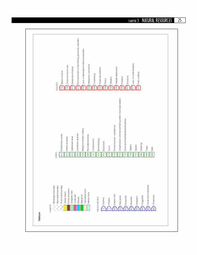
25CHAPTER 3 NATURAL RESOURCES

26
Figure 3.3. Coastal resource map of Kiamba, Sarangani Bay.

27CHAPTER 3 NATURAL RESOURCES

28
Figure 3.4. Coastal resource map of Maasim, Sarangani Bay.

29CHAPTER 3 NATURAL RESOURCES

30
Figure 3.5. Coastal resource map of General Santos City, Sarangani Bay.

31CHAPTER 3 NATURAL RESOURCES

32
Figure 3.6. Coastal resource map of Alabel, Sarangani Bay.

33CHAPTER 3 NATURAL RESOURCES

34
Figure 3.7. Coastal resource map of Malapatan, Sarangani Bay.

35CHAPTER 3 NATURAL RESOURCES

36
Figure 3.8. Coastal resource map of Glan, Sarangani Bay.

37CHAPTER 3 NATURAL RESOURCES

38
observed along the Saranganiand GSC coastline include thewhite sand beaches fronting theCelebes Sea and thick mangroveforest in the inner side ofSarangani Bay (Figure 3.9).Other coastal resources foundin the area include the followingmajor marine communities:seagrasses, seaweeds, coralreefs, and reef fishes. Thesemajor communities have beenassessed on separate occasionsby the academe, various national government agencies (NGAs), NGOs, and foreign-funded projects such as CRMP and MGP. The results of the survey are presentedbelow.
Mangrove CommunityMangroves play an important role in the ecological stability of the coastal ecosystemand other nearby ecosystems. They act as buffer zone against typhoons and tidalwaves, prevent soil erosion, and serve as land builders through soil accretion. Theyserve as nursery grounds for marine fishes, crustaceans, and other marine invertebrates.They provide refuge for wildlife such as birds, rodents, reptiles, amphibians, andmammals.
There is inadequate information on the mangrove community in the profilearea. Most of the available information focus on species identification and aerial coverestimate.
For the province, usingcombined data from municipalprofiles and the ProvincialEnvironment and Natural ResourcesOffice (PENRO), the mangroveforestlands were estimated at 267.6ha. Most of these are situated in themunicipalities of Maasim, Malapatan,and Glan.
On the other hand, based onland use statistics used by LouisBerger International, Inc. (LBII 1993),
Table 3.3. Mangrove forestlands of the profile area.
CENRO - Community Environment and Natural Resources OfficeCRMP - Coastal Resource Management ProjectENRO - Environment and Natural Resources OfficeMPDO - Municipal Planning and Development Office
Municipality/City
Mangrove forest(ha)
Source
AlabelGlanKiambaMaasimMaitumMalapatanGSCTotal
7.457.0
7.0150.0
15.022.9
8.3267.6
Glan CENRO (1996)Glan CENRO (1996)CRMP (1998)MPDO (1994)CRMP (1998)CRMP (1998)City ENRO (1988)
Figure 3.9. Extensive beach of Barangay Salakit, Kiamba.
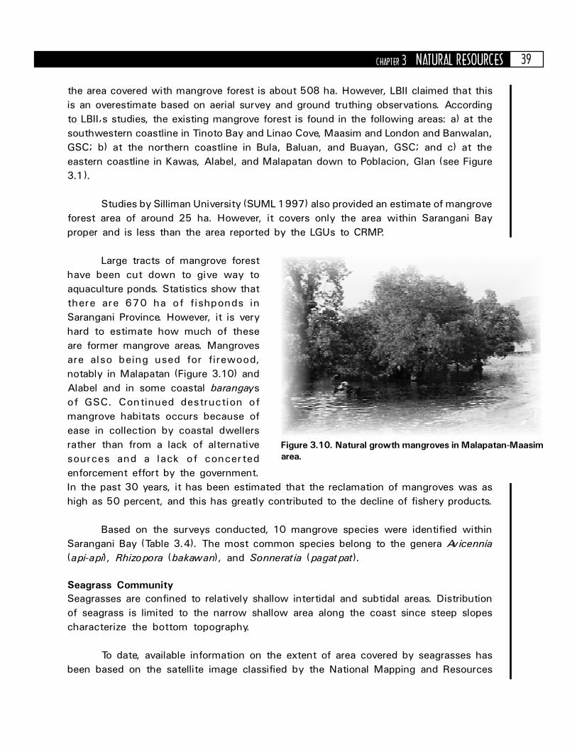
39CHAPTER 3 NATURAL RESOURCES
the area covered with mangrove forest is about 508 ha. However, LBII claimed that thisis an overestimate based on aerial survey and ground truthing observations. Accordingto LBII�s studies, the existing mangrove forest is found in the following areas: a) at thesouthwestern coastline in Tinoto Bay and Linao Cove, Maasim and London and Banwalan,GSC; b) at the northern coastline in Bula, Baluan, and Buayan, GSC; and c) at theeastern coastline in Kawas, Alabel, and Malapatan down to Poblacion, Glan (see Figure3.1).
Studies by Silliman University (SUML 1997) also provided an estimate of mangroveforest area of around 25 ha. However, it covers only the area within Sarangani Bayproper and is less than the area reported by the LGUs to CRMP.
Large tracts of mangrove foresthave been cut down to give way toaquaculture ponds. Statistics show thatthere are 670 ha of fishponds inSarangani Province. However, it is veryhard to estimate how much of theseare former mangrove areas. Mangrovesare also being used for firewood,notably in Malapatan (Figure 3.10) andAlabel and in some coastal barangaysof GSC. Continued destruction ofmangrove habitats occurs because ofease in collection by coastal dwellersrather than from a lack of alternativesources and a lack of concertedenforcement effort by the government.In the past 30 years, it has been estimated that the reclamation of mangroves was ashigh as 50 percent, and this has greatly contributed to the decline of fishery products.
Based on the surveys conducted, 10 mangrove species were identified withinSarangani Bay (Table 3.4). The most common species belong to the genera Avicennia(api-api), Rhizopora (bakawan), and Sonneratia (pagatpat).
Seagrass CommunitySeagrasses are confined to relatively shallow intertidal and subtidal areas. Distributionof seagrass is limited to the narrow shallow area along the coast since steep slopescharacterize the bottom topography.
To date, available information on the extent of area covered by seagrasses hasbeen based on the satellite image classified by the National Mapping and Resources
Figure 3.10. Natural growth mangroves in Malapatan-Maasimarea.

40
Information Agency (NAMRIA) in 1993. Theimage was based on spot multi-spectral datataken on 5 April 1987. It covers only the areaof Sarangani Bay. Based on NAMRIA�spreliminary classification, the shallow reefareas with seagrasses cover an area of 9.81km2 from Taliak Point, Maasim to Lefa Point,Glan.
Aside from NAMRIA, LBII (1993) alsodid visual identification and aerial coverestimates of the seagrass community. Thecoastal areas identified with seagrasscommunities include Tinoto, Maasim;Tambler, GSC; Malapatan; Taluya, Gumasa;and Burias, Glan (Figure 3.1). The identifiedspecies were Enhalus acoroides, Halophilaspp., and Thalassia hemprichii (Table 3.5).
SUML (1997) also did aseparate survey of the seagrasscommunity in the area. Thesurvey included the following:Kawas Point, Alabel; Gumasaand Lago Point, Glan; LinaoCove and Tinoto, Maasim; LunPadidu, Malapatan; andPoblacion, Kiamba. In theseareas, seagrass covers anestimated area of 0.27 km2.Aside from the previouslymentioned species, other
species observed were Cymodocea, Syringodium, Halophila, and Thalassodendron.The latter species is rare and can only be found in southern Philippines. Small quantitiesof this species were observed in Gumasa. However, a wide bed of this species hasbeen found in Batulaki, Glan by the Sarangani CRMP team. The team also observedseagrass communities of Thalassia and Enhalus in Siguel, GSC.
Siltation coming from the rivers and tributaries emptying into Sarangani Bayposes a major threat to the seagrass ecosystem. Unfortunately, no action has beentaken to address the problem. So far, no solution has been implemented for thisproblem, since some of the sources fall outside of the jurisdiction of Sarangani andGSC.
Table 3.4. List of mangrove species in Sarangani Bay.
Source: LBII (1993); SUML (1997)
Mangrove species Local name
RHIZOPHORACEAERhizophora mucronataRhizophora apiculataCeriops decandra
AVICENNIACEAEAvicennia marina
SONNERATIACEAESonneratia alba
COMBRETACEAETerminallia catappa
MYRSINACEAEAegiceras floridum
EUPHORBIACEAEExcoecaria agallocha
FABACEAEPongamia pinnata
LYTHRACEAEPemphis acidula
Bakhaw bayeBakhaw lakiMalatangal
Piape baye
Pagatpat
Talisay
Tinduk-tindukan
Alipata, Buta-buta
Taualis
Bantigi
Table 3.5. List of seagrass species identified in the coastal areas ofSarangani Province and GSC.
Source: LBII (1993); SUML (1997)
Seagrass species Municipalities where they are found
Cymodocea rotundataCymodocea serrulataEnhalus acoroidesHalodule pinifoliaHalodule uninervisHalophila ovalisHalophila spinulosaSyringodium isoetifoliumThalassia hemprichiiThalassodendron ciliatum
Malapatan, Glan, Alabel, KiambaGlanMaasim, Alabel, GlanMaasim, Malapatan, Glan, Alabel, KiambaGlan, AlabelMaasim, Malapatan, Alabel, KiambaKiambaMaasim, Malapatan, Glan, AlabelMaasim, Malapatan, Glan, AlabelGlan

41CHAPTER 3 NATURAL RESOURCES
Coral Reef and Reef Fish CommunitiesLBII (1993) also conducted coral reef assessment in the area. A total of 28 reef areasalong the coasts of Sarangani Province and GSC have been surveyed. Of the 28 sitessurveyed, only 8 sites have coral cover exceeding 50 percent; 6 sites between 40 and49 percent; 2 sites between 30 and 39 percent; and the rest of the 12 sites, below 30percent. The sites with coral cover greater than 50 percent are found in Tinoto Bay,Maasim; Glan; Alabel; and Malapatan (Table 3.6, Figure 3.1).
Table 3.6. Percentage coral cover, substrate, and algae in the profile area.
Source: LBII (1993)
Location
ALABELKawas PointGLANBurias PointSagby PointNibongTaluya PointBato MaputiLago PointHagdan PointTinaca PointTikang PointManibongDongonGumasaBatulakiGSCTamblerBual PointMALAPATANMalapatan (north)Malapatan (south)MAASIMLinao CoveMalbongLumasalKatubaoTampuan Point (slope)Tinoto Bay (mangrove)Tampuan Point (wall)Tampat PointTinoto Bay (cliff)
Hardcorals
Softcorals
Algae Deadcorals
Sand andsilt
Rubble
58.0637.8926.6446.5840.5311.9643.8475.3425.9629.5214.8346.2065.9427.32
22.41
50.6644.8856.4446.3565.1639.0537.8027.0816.4855.1963.7647.3465.27
2.8015.0312.5012.4421.7759.3629.06
0.0012.6413.24
7.270.003.088.94
0.00
7.668.327.008.230.00
29.273.02
13.4415.58
0.002.360.10
10.26
1.684.210.600.100.000.000.000.00
16.929.227.204.507.144.88
0.15
6.347.665.028.206.421.375.86
25.105.842.42
15.677.163.96
11.2612.7919.9018.58
7.2718.8811.047.866.766.02
15.0320.4811.929.68
6.01
10.2620.52
0.007.345.472.90
26.343.801.342.776.018.568.85
13.5212.6820.5616.7021.007.30
10.709.00
12.6414.4611.6012.84
3.0012.38
26.92
9.2811.067.508.690.000.00
10.809.04
22.7024.93
0.128.282.33
9.7013.7521.805.600.002.505.367.70
19.8819.7439.0012.56
4.9225.96
29.66
9.655.70
13.6014.3820.2824.27
4.7015.1031.187.133.62
17.665.50
Based on LBII�s report, 42 coral genera were identified. The dominant generaare Acropora, Porites, Diploastrea, Goniopora, Montipora, and Favites.
At the time of the LBII study, dynamite fishing was prevalent. This was theresponse of subsistence fishers against the purse seine method of commercial fishers.

42
Both methods are highly destructive to corals. However, based on interviews conductedin 1994, dynamite fishing was not as prevalent as in the past. However, commercialfishing within municipal waters was still a problem.
Other destructive fishing methods used in Sarangani Bay that have causeddegradation to the coral cover include lintig or muro-ami and poison fishing.
Apart from destructivefishing, there has also been someextraction of corals (Figure 3.11).However, this is not so prevalent.Only a small trade in dried andpainted corals by Badjaos exists inresort beaches in the area. This isprimarily because tourism is notdeveloped in the area.
Table 3.7 shows that thereefs are heavily exploited. This isindicated by the small size of fishand the scarcity of commerciallyvaluable species. However,abundance and diversity are
dependent on coral cover. In all of the sites surveyed by SU, most fish were small withvery few species of commercial value. It is obvious that habitat degradation andoverfishing have taken their toll.
A major threat to corals as well as the whole coastal ecosystem is thesedimentation due to erosion and siltation of denuded watershed and improperagricultural practices. These threats and issues are described in more detail inChapter 7.
Table 3.7. Number of fish species, fish abundance, and biomass estimates in Sarangani Province including GSC.
Source: LBII (1993). No data collected for the Municipality of Maitum.
Municipality/City
AlabelGlanGSCKiambaMaasimMalapatan
No. ofsites
surveyed
Areasurveyed
(m2)
No. offish
species
Density(no./m2)
Range ofbiomass(mt/km2) No. of
species1
131292
5006,100
3001,0003,9001,000
1211
<12
Biomass(mt/km2)
37140
3045
13844
842
77
509
10.753.03-102.22
19.2311.65-15.9512.75-57.51
2.56-6.26
1.639.573.002.398.160.36
Commerciallyimportant species
Figure 3.11. Excellent cover of Acropora (branching corals) foundin Tuka Marine Park, Kiamba.

43CHAPTER 3 NATURAL RESOURCES
Within the reef area surveyed, fish species composition and production valueestimates were also conducted (Table 3.7). A total of 191 reef fishes were identified.Fish biomass estimates ranged from 2.56 to 102.22 mt/km2. The highest fish biomassestimate was observed in Glan, while the lowest was in Malapatan. The highest fishbiomass estimates for commercially important species were observed in Glan (9.57mt/km2) and Maasim (8.16 mt/km2) represented by 42 and 50 species, respectively(LBII 1993).
Among the fish species observed, the most represented families arePomacentridae (42 species), Labridae (34), Chaetodontidae (18), and Acanthuridae(12) (Table 3.8).
Table 3.8. List of fish families and species observed.
Source: LBII (1193) and Participatory Coastal Resource Assessment 1998-99
Family
AulostomidaeAcanthuridaeApogonidaeBalistidaeBlennidaeCaesionidaeCarangidaeCentriscidaeChaetodontidaeCirrhitidaeDasyatidaeDiadontodaeEphippidaeFistulariidaeGobiidaeHaemulidaeHolocentridaeLabridaeLethrinidaeLutjanidaeMicrodesmidaeMonacanthidaeMullidaeMuraenidaeNemipteridaeOstraciidaePinguipedidaePlotosidaePomacanthidaePomacentridaePriacanthidaeScaridaeScorpaenidaeSerranidaeSiganidaeSphyraenidaeSyngnathidaeSynodontidaeTetraodontidaeZanclidae
Common name No. of species
MGP (1993)SurgeonfishCardinalfishTrumpetfishTriggerfishBlennyFusilierScad and jackShrimpfishButterflyfishHawkfishStingrayPorcupine fishBatfishFlutemouthGobySweetlipSquirrelfishWrasseEmperorSnapper
FilefishGoatfishMoray eelThreadfin breamBoxfishSandperchSea catfishAngelfishDamselfishBig-eyeParrotfishScorpionfish and stonefishGrouperRabbitfishBarracudaSeahorseLizardfishPupperfishMoorish idol
123150421
1831001114
3415229211117
428608011031
193
219071821
2351222048
3816059243316
505
110
21000341
269
CRMP (1999)

44
The family Pomacentridae (damselfishes) is the most numerous fish species.This includes the following species: Chromis ternatensis (18 percent of the totalnumerical abundance), Neoglyphidodon melas (13 percent), Chromis atripectoralis (8percent), Acanthochromis polyacanthus (7 percent), Pomacentrus coelestis (7 percent)and Pomacentrus moluccensis (6 percent). The most dominant species by biomass arerepresented by the species Neoglyphidodon melas (22 percent of the total biomass),Taeniura lymma (12 percent), Chromis ternatensis (8 percent), Ctenochaetus striatus(5 percent), and Pomacentrus moluccensis (3 percent).
SeaweedsThe only available seaweed information in the area came from the studies conductedby SUML (1997). Sixty-six species were identified belonging to division Chlorophyta(green algae), Cyanophyta (blue-green algae), Phaeophyta (brown algae) andRhodophyta (red algae).
The most common seaweed species sold in the market are Caulerpa sp. (lato)and Eucheuma sp. (guso). In Kawas, Alabel, fisherfolk allege that there is a bed ofCaulerpa sp. covering an area of at least a hectare at 70 ft deep. However, this has yetto be verified.
Other Marine FaunaLBII (1993) has indicated that marine mammals such as whales, dolphins, and seaturtles are common in the area. The Earth Island Institute (EII) confirmed this reportand indicated that there are 5 species of whales and 7 species of dolphins in the area.However, there is no available listing of species observed. Sharks have also been observedin the area, particularly, the whale shark (Rhincodon typus).
Dugong (Dugong dugon)is present in the area particularlyin Glan and Kiamba (Figure 3.12).Researchers of the Department ofAgriculture-Bureau of Fisheriesand Aquatic Resources (DA-BFAR)and other agencies who monitorSarangani Bay have verified this.Dugong have also been foundbeached in the coastal areas ofGlan.
Surfacing sea turtles is acommon sight in the coastalwaters of Sarangani. The most
Figure 3.12. Dugong washed on the shoreline of SaranganiBay in Glan.

45CHAPTER 3 NATURAL RESOURCES
common species is the green sea turtle(Chelonia mydas) and on some occasions thehawksbil l (Eretmochelys imbricata). Thepresence of sea turtles in the area was alsoverified by the CRMP team which saw theanimal above and underwater in Kawas, Alabel,and Kiamba, respectively (Figure 3.13).
Tuka Marine Sanctuary, KiambaOne marine sanctuary in Sarangani Bay has beencarefully monitored since 1997 with theassistance of UP-MSI and CRMP incollaboration with local government andacademia in Sarangani. The Tuka MarineSanctuary in Kiamba covers about 10 hectaresof coral reef area and was marked with buoysand signs in 1998. Although the ordinance wasonly recently passed, the sanctuary has beenpractically enforced since 1997 and hasdemonstrated the positive results of coral reef
protection. The living hard corals inside the santuary have improved from an averagecover of 42.7 percent in 1998 to 55 percent in 2001 (Figure 3.14). Similarly, theabundances of fish inside and outside of the sanctuary have increased substantiallyover the 3 year period (Figure 3.15).
0
1998
Perc
ent
livin
g h
ard
cora
l
1999 2000 2001
10
20
30
40
42.7 42.745.8
55
50
60
Figure 3.14. Change in living hard coral cover inside the Tuka MarineSanctuary from 1998 to 2001.Source: Uychiaoco et al. 2001
Figure 3.13. Newly hatched green seaturtles found in Lomuyon, Kiamba.

46
0
1998 1999 2000 2001
200
400
600
800
1000
1200
1400
0
1998 1999 2000 2001
50
100
150
200
250
Legend:
Inside
Outside
All fish
Num
ber
of
fish p
er
500 m
2
Target species of fish
Figure 3.15. Change in fish abundances (number of individuals within 500 m2 area) inside and outside of the TukaMarine Sanctuary from 1998 to 2001.Source: Uychiaoco et al. 2001
SUMMARYThe rich coastal and marine resources of Sarangani Bay are being increasingly impactedby development. Trends indicate declining coral reef and mangrove areas anddeteriorating water quality. The productive coastal ecosystems require protection andmanagement and stabilization of water quality to ensure long-term fish productionand access to the other associated benefits of these valuable coastal resources.

47CHAPTER 4 SOCIOPOLITICAL SETTING
POLITICAL/ADMINISTRATIVE BOUNDARIES
arangani Province is bounded on the north by the Province of SouthCotabato, on the east by Davao del Sur, on the south by the CelebesSea, and on the west by Sultan Kudarat. The 6 municipalities ofSarangani Province are politically and physically divided into 2 clusterswith 3 municipalities in each cluster. The cluster on the eastern side iscomposed of Alabel, Malapatan, and Glan while the cluster on thewestern side is composed of Maasim, Kiamba, and Maitum. Dividing
the 2 clusters are the GSC on land and Sarangani Bay on water (see Figure 1.1).
The number of coastal barangays in the municipalities of Sarangani is shown inFigure 4.1. Glan and Kiamba have the highest number of coastal barangays, whileAlabel has the least. There are 67 coastal barangays in total.
The municipality, city, and its coastal barangays are shown in Figures 4.2 to4.8. A strip of area at the border of Malapatan and Davao del Sur is a disputed land.However, the PPDO does not mention the total area involved in the dispute.
DEMOGRAPHYThe demographic data presented in this section are taken from the results of the 1990and 1995 census conducted by the National Statistics Office (NSO) and the municipalIntegrated Rural Accessibility Planning (IRAP) data of 1993.
Chapter 4SOCIOPOLITICAL
SETTING
s

48
Figure 4.1. Number of coastal and total barangays in the profile area.
Figure 4.2. Alabel coastal barangays.
03
1613 12
7 69
Alabel Glan Kiamba Maasim Maitum Malapatan GSC
5
10
15
20
25
30
35
40
45
50
12
31
1916
19
12
25
Non-coastal barangays Coastal barangaysTotal Coastal = 66
Total = 134
General
Santos City
6.20
6.15
6.10
6.05
6.00
125.16 125.21 125.26 125.31 125.36
Sarangani Bay
East longitude
Nort
h latitu
de
Alabel
Legend
Maribulan
Alabel
Kawas
Malapatan
Provincial boundary boundary
Main RoadBarangay

49CHAPTER 4 SOCIOPOLITICAL SETTING
Figure 4.3. GSC coastal barangays.
Figure 4.4. Glan coastal barangays.
6.20
6.15
6.10
6.05
6.00
5.95
5.90
124.90 124.95 125.00 125.05 125.10 125.15 125.20 125.25 125.30
Provincial boundary boundary
Main RoadBarangay
Legend
East longitude
Nort
h latitu
de
Gen. Santos City
Alabel
Maasim
Sarangani BaySiguel
Tambler
Calumpang
Dadiangas
BulaBaluan
Buayan
Labangal
Sarangani Bay
Kapatan
Lago
Tango
TaponPoblacion
Taluya
Gumasa
Kablalan
Baliton
Pangyan
Mudan
Small Margus
Big Margus
San Jose
Batu Laki
Malapatan
Glan
Davao
del Sur
Celebes Sea
5.95
5.90
5.85
5.80
5.75
5.70
5.65
5.60
5.55
125.15 125.20 125.25 125.30 125.35 125.40 125.45
Provincial boundary boundary
Main RoadBarangay
Legend
East longitude
Nort
h latitu
de

50
Figure 4.5. Kiamba coastal barangays.
Figure 4.6. Maasim coastal barangays.
6.15
6.10
6.05
6.00
5.95
5.90
124.50 124.55 124.60 124.65 124.70 124.75 124.80 124.85 124.90
Provincial boundary boundary
Main RoadBarangay
Legend
Maitum
Celebes Sea
Kiamba
Maasim
Salakit
LumaLebe
Nalus
Badtasan
Kapate
Datu Dani
Tambalil
Lagundi
Kling
Kayupo
Lomuyon
KatubaoSuliKiamba
East longitude
Nort
h latitu
de
Provincial boundary boundary
Main RoadBarangay
Legend6.04
6.02
6.00
5.98
5.96
5.94
5.92
5.90
5.88
5.86
5.84
5.82
124.85 124.90 124.95 125.00 125.05 125.10124.80
Kiamba
Maasim
Gen. Santos City
Celebes Sea
Sara
ngani Bay
Lumasal
Pananag
Kanalo Lumatil
Daliao Kablacan
KabatiolPoblacion
Colon
Malbang
Kamanga
Tinoto
East longitude
Nort
h latitu
de

51CHAPTER 4 SOCIOPOLITICAL SETTING
Figure 4.8. Malapatan coastal barangays.
Figure 4.7. Maitum coastal barangays.
Provincial boundary boundary
Main RoadBarangay
Legend
6.25
6.20
6.15
6.10
6.05
6.00
124.30 124.35 124.40 124.45 124.50 124.55 124.60 124.65
East longitude
Nort
h latitu
de
Sultan
Kudarat
Maitum
Kiamba
Celebes Sea
Pinol
Maguling
Mindupok
Kalaong
Mabay
Maitum
Kiambing
6.15
6.10
6.05
6.00
5.95
5.90
5.85
125.25 125.30 125.35 125.40 125.45 125.50
Provincial boundary boundary
Main RoadBarangay
Legend
Sara
ngani Bay
Alabel
Malapatan
Glan
Lun Padidu
Lun Masla
Tuyan
Malapatan
Lasang
Sapu Padidu
Sapu Masla
East longitude
Nort
h latitu
de

52
Population Size, Density, and Growth RateThe 1995 total population of the 6 municipalities and 1 city in the profile area is603,741. Of this, 69 percent live in coastal barangays. This is up by more than 10percent from the 1990 data (Table 4.1).
Table 4.1. Population size, density, and growth rate of the coastal municipalities of SaranganiProvince and GSC, 1990 and 1995.
Source: NSO (1992)
The growth rates exhibited by Malapatan, Maitum, and GSC are way over thenational growth rate for the same period, which is 2.32 percent. This is primarily dueto the rapid growth and urbanization occurring in GSC, which is attracting a lot of in-migration. Sarangani is also the fastest growing province in Region XI with an annualgrowth rate of 4.98 percent, while GSC has the highest annual population growthrate in the region.
The growth rate in Alabel seems to have decreased by 2.21 percent comparedto the previous decade.
Population density is below the national figure of 228 persons/km2, except forGSC. However, if one takes into account the coastal barangays only, one will note ageneral increase in population density, with Alabel, Glan, and GSC going over thenational figure. This suggests that more people tend to live in the coastal areas.
Based on Tables 4.1 and 4.2, one can see that the population is highlyconcentrated in the coastal barangays.
HouseholdsTable 4.3 compares household size and number from the 1990 and 1995 census. Thetable shows that household size is decreasing. However, in line with the populationincrease, the number of households has also increased. While population has increasedby 20 percent, households have increased by 25 percent. This is consistent withnational figures, which show a trend of decreasing household size. In 1980, the average
Municipality/City
AlabelGlanKiambaMaasimMaitumMalapatanGSCTotal/Average
Population
40,73060,37535,38626,72525,61936,230
249,678474,743
46,52773,76839,71731,64135,00947,911
327,173601,746
758785377948
466125
1990 1995
Annual growth rate(percent)
1980-90 1990-95
Population density(persons/km2)
1990 19954.742.142.211.550.301.925.262.60
2.533.832.173.216.965.375.554.23
861069543
10863
674168

53CHAPTER 4 SOCIOPOLITICAL SETTING
household size in the Philippineswas 5.6. In 1990, it became 5.3 andin 1995, the figure was 5.1.
Age and Gender CompositionThe population across age groupsis gradually decreasing (Figure 4.9).This is an indication that there hasbeen no epidemic or catastrophicevent in the area for the pastdecades. The population shows anormal age distribution where the
younger population dominates. In the entire area, 72 percent of the population isbelow 30 years old, indicative of a very young community.
In Sarangani Province, the population of the productive age group (15 to 64years old) accounts for 39.5 percent of the population, while in GSC, it accounts for54.1 percent. The dependency ratio for Sarangani is 84.9 percent, while that of GSCis lower at 70.6 percent. The productive population for the whole area accounts for56.79 percent, which is higher than the national average of 42 percent. This validatesthe fact that the area is indeed a center for economic growth. The 65+ group for theprofile area city/municipalities accounts for only 2.14 percent of the total population,which is lower than the national average of 3.4 percent (Table 4.4).
The male to female sex ratio for the entire area is almost even with the numberof males slightly higher than the number of females. The Sarangani figures are alsoslightly higher than the national figures (101 males to 100 females). There are 107males for every 100 females in Sarangani. Even in GSC, the figures are still slightlyabove the average at 102 males for every 100 females.
Table 4.2. Population size and density of coastal barangays per municipality of SaranganiProvince and GSC.
Data from NSO (1996) and the Provincial Planning and Development Office 1994
Table 4.3. Household size and number of households permunicipality/city.
Municipality/City
AlabelGlanKiambaMaasimMaitumMalapatanGSCAverage/Total
Householdsize
5.45.45.45.35.65.05.45.4
5.04.95.34.95.25.25.05.1
1990 1995
No. ofhouseholds
19907,564
11,1976,6164,8125,1346,554
46,14488,021
9,38413,919
8,0196,0766,6919,177
65,509118,775
1995
Municipality/City
AlabelGlanKiambaMaasimMaitumMalapatanGSCTotal/Average
Total population ofcoastal barangays
18,22639,39830,22222,51611,99723,180
101,183246,722
20,08745,81032,21726,75212,89930,747
150,090318,602
1990 1995
Population density of coastalbarangay (persons/km2)
1980-90 1990-9543317911560
17950
98586
477275123
71193
66994314

54
Urban and Rural PopulationDistributionThere are no urban and ruralpopulation distribution data in the1995 census. The 1980 and 1990censuses were used instead (Table4.5). From the data, most of thepopulation in Sarangani Province livein rural areas and only Malapatan hasgreater than half of its populationliving in urban areas. As expected,most of GSC�s population (98percent) live in urban areas.
EducationForty percent of the population 5years old and over attended orcompleted elementary education inGSC. Sarangani has a much higherfigure of 56 percent. However, inSarangani, a much higher percentage
Table 4.4. Age group breakdown per municipality/city, 1995.
of population has no grade completed (12.6 percent), while GSC only has 2.5 percent.Those who reached or completed high school in GSC comprise 33.7 percent of thepopulation (5 years and over), while in Sarangani it is 20.8 percent. Academic degreeholders are 6.5 percent of the population in GSC and 2.1 percent in Sarangani Province.Only a very small percentage of the population has any post-baccalaureate degree(0.1 percent for Sarangani and 0.2 percent for GSC). The complete breakdown isshown in Figure 4.10.
Figure 4.9. Age-sex population pyramid, Sarangani, 1995.Percent to Total Population
Age G
roup
10-14
20-24
30-34
40-44
50-54
60-64
70-74
Under 5
80-84
Male Female
5 510 100
Municipality/City
AlabelGlanKiambaMaasimMaitumMalapatanGSCTotal per age group% of Total per agegroup
Age group
0 to 14 years 15 to 64 years 65 years and above
Total
Population % Total Population % Total Population % Total
20,04632,24616,78013,90314,37420,748
129,086247,183
43.143.742.243.941.043.139.4
41.1
25,38539,81921,65917,02219,70426,292
191,833341,714
54.654.054.553.8
56.3854.958.6
56.8
1,0961,7031,278
716931871
6,25412,849
2.42.33.22.32.61.82.0
2.1
46,52773,76839,71731,64135,00947,911
327,173601,746
100100100100100100100
100
TotalPopulation
% Total

55CHAPTER 4 SOCIOPOLITICAL SETTING
The literacy rate for Sarangani is 85.7 percent. GSC has an urban literacy rateof 96.3 percent and a rural literacy rate of 78.1 percent. The national literacy rate is89 percent.
Sarangani Province has 180 elementary/primary schools, 17 secondary schools,and 2 vocational schools. There is also 1 university that offers various courses. Inaddition to these, Sarangani has 95 non-formal adult education classes.
GSC has 24 private pre-schools, 54 public schools, and 23 private elementaryschools. There are also 16 public/state secondary schools, 6 private secondary schools,5 colleges, and 14 technical and vocational schools.
Table 4.5. Urban and rural population breakdown, 1980 and 1990.
Municipality/City
AlabelGlanKiambaMaasimMaitumMalapatanGSCTotal/Average
Urban population
8,1817,2155,4323,5292,4618,240
94,176129,234
11,45714,69612,464
8,7147,900
18,483243,702317,416
1980 1990Rural population
1980 Urban17,43941,66723,03519,38622,83521,72555,222
201,309
3.437.378.669.46
12.378.419.978.52
Average growth rate199029,27345,67922,92218,01117,71917,747
5,976157,327
Rural5.320.92
-0.05-0.73-2.51-2.00
-19.94-2.71
Figure 4.10. Highest education completed for GSCand Sarangani.Source: NSO (1996, 1997a, 1997b)
High School34%
Elementary40%
CollegeUndergraduate
9%
Academic DegreeHolder
9%
No GradeCompleted
3%
Post-Secondary2%
Pre-School2%
Not Stated1%
PostBaccalaureate
0%
General Santos: 1995
Sarangani: 1995
High School34%
Elementary40%
CollegeUndergraduate
3%
Academic Degree
Holder2%
No GradeCompleted
13%
Post-Secondary1%
Pre-School
2%
Not Stated
2%
PostBaccalaureate
0%

56
Labor and EmploymentThe NSO data on labor and employment take into consideration the portion of thepopulation 15 years old and over. In Sarangani, it comprises more than 55 percent ofthe total population, while in GSC it is 58 percent. In GSC and Sarangani, the mostcommon trade skill involves driving and mobile machinery operations. The least commontrade involves plant and related operations (Figures 4.11 and 4.12).
However, based on a limited survey by LBII, the coastal households are dependenton fisheries for employment. More than a third of the livelihood in coastal barangaysare dependent on fisheries-related activities. Table 4.6 shows the result of the LBIIsurvey in 1994.
Table 4.6. Distribution of occupation in coastal barangays.
Source: LBII (1993)
Occupation
Municipal fishingCommercial fishingFish vendingOther fishery-related occupations
(boatmaking, boat rental, bangusfry gathering, and others)
Farming/store owner
Distribution(percent)
26262317
8
Figure 4.11. Household population 15 years old andover by trade skill, Sarangani, 1995.Source: NSO (1996, 1997a, 1997b)
Other Skills36%
Driving and Mobile
Machinery Operation
16%
Other Crafts
16%
Mining,Construction
10%
Not Stated8%
Precision
Handicraft6%
MetalMachinery
4%
Machine Operationand Assembly
3%
Stationary Plant1%
Figure 4.12. Household population 15 years old andover by trade skill, GSC, 1995.Source: NSO (1996, 1997a, 1997b)
Other Skills33%
Driving and MobileMachinery Operation
24%
Mining,Construction
11%
Other Crafts11%
Metal,Machinery
10%
Not Stated5%
MachineOperation and
Assembly3%
Precision,Handicraft,
Printing2%Stationary
Plant1%
Usually, the male members of thehousehold fish while the women sell thecatch and tend to be active in fisheryassociations. Farming or runningconvenience stores supplement theincome derived from fisheries.
In GSC, the majority of the laborforce is engaged in services (35.3percent). Fishing comprises 19.9
percent. In Sarangani Province, agriculture accounts for 70.2 percent. Agriculture alsocovers the hunting and forestry sector. The fishing sector accounts for 8.2 percent.

57CHAPTER 4 SOCIOPOLITICAL SETTING
In Sarangani Province, the employment rate is 94.7 percent and it has a laborfor participation rate of 83.4 percent. Unemployment in the province is 5.3 percent,and visible underemployment is at 16.5 percent. In GSC, the employment rate is 89.4percent. The national employment rate is 91.3 percent; unemployment rate is 8.7percent; and underemployment rate is 23.1 percent.
Religious and Ethnic GroupsThere are 29 different religious groups inSarangani and GSC based on the 1990 census.For the province, the most common is theRoman Catholic (63 percent of the population).Other religious groups are Islam (9 percent),Protestant (6 percent), United Church of Christin the Philippines (6 percent), Alliance of BibleChurch Community (3 percent), and Iglesia niKristo (2 percent) (Figure 4.13).
In terms of ethnic delineation, there are5 major groups for the province. These are theCebuano and Waray (from Cebu, Leyte, Bohol, Negros Oriental, and others), Hiligaynon(from Negros Occidental, Romblon, Antique, Iloilo, Aklan, and Capiz), cultural minorities(such as B�laan, Manobo, T�boli, Tagacaolo, and Dabaweno), Muslim group and tribe(Maguindanao, Maranao, Kalagan, Tausug, Badjao, Sangil, and others), and the Luzongroup (Tagalog, Ilocano, Pampangueño, and others). The most numerous group is theCebuano and Waray (52 percent) followed by the cultural minorities (21 percent),Hiligaynon (9 percent), Muslim group (8 percent), and Luzon group (7 percent).
DialectsNinety-four local dialects and 4 foreign languages are being spoken in the entireSarangani Province. The foreign languages are Chinese, English, German, andIndonesian. English is widely spoken and taught in school. The Indonesian languagealso has considerable influence. The speakers of this language are concentrated in themunicipalities of Glan and Maasim. The Indonesian-speaking people are actuallyforeigners, many of whom are fishers. However, the legality of their stay in the Philippineshas not been ascertained.
For the local dialects, the most spoken is Cebuano (55 percent of the provincialpopulation). Other dialects with large users are Hiligaynon (11 percent), Badjao (10percent), Maguindanao (5 percent), Ilocano (4 percent), T�boli (3 percent), and Tagalog(3 percent). However, at the municipal level, the distribution is different. AlthoughCebuano is the major dialect, some dialects also dominate such as Ilocano and T�boliin Kiamba and Maitum. T�boli is also spoken by many people in Maasim. Figure 4.14shows the distribution of spoken dialects.
Figure 4.13. Composition of religious groups inSarangani Province.
Others
11%
INK
2%
ABCC
3%
UCCP
6%
Protestant
6%
Islam
9%
Roman Catholic63%

58
HEALTH, SANITATION, AND MEDICAL CAREThere are 4 primary (10-bed capacity) and 1secondary (25-bed capacity) hospitals inSarangani Province. The district hospital islocated in Kiamba. Only the municipalities ofAlabel and Malapatan do not have primaryhospitals. However, all municipalities have ruralhealth centers. There is also a medicarehospital located in Glan with a 15-bedcapacity.
The entire province has 14 medicaldoctors, about 32 nurses, 93 midwives, 5
pharmacists, 7 medical technologists, 10 sanitary inspectors, 2 nutritionists, 8 dentists,2 X-ray technicians, and 629 barangay health workers. Most of them are in secondaryhospitals and in private clinics. Medical doctors visit rural health centers on a sporadicbasis. However, a nurse or a midwife stays at these centers during regular workingdays.
In GSC, there are 4 tertiary, 1 secondary, and 2 primary hospitals equipped withmodern health facilities and medical personnel. Each tertiary hospital has at least a100-bed capacity while the primary hospitals complementing them have at least a 10-bed capacity. There are also 62 clinics in the area.
SETTLEMENTSHouses in the coastal areas of the province can be classified as made from lightmaterials, semi-permanent, or permanent (concrete) residences. Majority of the housesare made of light materials (83 percent) and only 4 percent are permanent. In terms ofownership, 90 percent own their house. In terms of lot ownership, only 32 percentown lots (Table 4.7). The problem of land tenure and squatting in coastal areas willbecome more of an issue as increasing land development takes place.
In the survey conducted by LBII, majority (45 percent) of coastal dwellers live inwooden/mixed houses. Thirty-three percent live in huts made of light materials likenipa and bamboo, while the remainder live in makeshift houses.
ROADS, TRANSPORTATION AND COMMUNICATION, AND RELATEDINFRASTRUCTURE OR SUPPORT SYSTEMSSarangani Province�s 2,691.4-km road network consists of 270.97-km national road,454.5-km provincial road, 162.44-km municipal road, and the rest are barangay roads.GSC, on the other hand, has a 434.118-km road network. Thirteen percent of this arenational roads, while 43 percent are city roads.
Figure 4.14. Dialects spoken in Sarangani Province.
Cebuano55%
Others9%
Tagalog3%
T�boli3%
Ilocano4%
Maguindanao
5%
Badjao10%
Hiligaynon11%

59CHAPTER 4 SOCIOPOLITICAL SETTING
The road network includes an all-weather 178-km road network connecting10 major municipalities to GSC (Figure4.15). This network was completed in 1994at a cost of US$63.3 million. This projecthas significantly reduced travel time, fares,and hauling costs in the area.
In Sarangani, Land TransportationOffice records show a total of 3,180registered motor vehicles. Of these, 1,184are cars/jeeps, 1,499 are motorcycles, and497 are trucks, buses, and trailers. GSC,on the other hand, has 19,610 registeredmotor vehicles. Of these, 6,566 are cars andjeeps, 11,593 are motorcycles, and 1,451 are buses and trailers. GSC has a largervehicle count since most vehicle owners in Sarangani register in GSC. At least 5 majortaxi and rent-a-car companies operate in the city.
The Department of Public Works and Highways reported in 1993 that SaranganiProvince has a total of 43 bridges with a total length of 2,117.81 m. This includespermanent and temporary bridges, concrete, bailey, timber, and RCIB bridges.
Sea transport including cargo loading and passenger traffic in the area is throughMakar Wharf. Four major shipping lines (William Lines, Inc., W&GA Company, SulpicioLines, and Negros Navigation) ply the Manila-GSC Route with varying stopovers. Traveltime ranges from 35 to 56 hours.
Table 4.7. Percentage composition of house types and ownership in some areas in the coastalmunicipalities of Sarangani Province.
Source: SUML (1997)
Figure 4.15. Part of the 178-km road network connectingGSC to the 10 major municipalities.
House type andownership
No. of respondentsHouse typeLight materialsSemi-permanentPermanentHouse ownershipHouse ownedHouse owned by
relativeLand ownershipLot ownedLot owned by
relative
LinaoPoint
Tinoto,Maasim
Kawas Point,Alabel
LunPadidu
Suli LagoPoint
Gumasa Total
16
9460
5638
3664
54
7815
7
982
4060
23
7822
0
1000
3367
40
632315
973
2872
44
9190
8413
1783
40
90100
7723
3070
35
9703
1000
3961
252
8412
4
8711
3268
60
To support Makar Wharf, secondary ports will be developed in Alabel and Glan.This is supposed to handle short-haul domestic inter-island shipping. A port in Glanalready exists, but it needs to be completed including yard expansion and pier widening.There is also a small port in Kiamba, but this only caters to fish landing and farmproduce.
The GSC International Standard Airport serves as a jump-off point to both thecity and Sarangani. The airport costs US$50 million and includes a 3,200-m runway, 2taxiways, 1 apron, a terminal building, flight and emergency service stations, hangarand fueling station, cargo handling equipment, and cold storage.
The airport can be reached via a 1.5-hour flight from Manila. There are alsodirect flights to the city from Davao, Cagayan de Oro, Zamboanga, and Cotabato. In1997, the Air Transportation Office reported that passenger traffic through the airportstood at 142,537 while cargo was at 3,587,105 mt.
GSC has modern telecommunication facilities that include international directdialing (IDD) and national direct dialing (NDD) telephone service, public call offices,and telegram systems. These include such companies as Pilipino Telephone Corporation(PilTel), Philippine Telegraphic and Telecommunications Company (PT&T), and RCPI.Facsimile services, cellular telephones (Smart, Mobiline, Globe-Telecom), pager systems(Easycall, Pocketbell, Mobiline), VHF radio systems, and Internet service providers(ISPs) are available. In 1996, PilTel installed 8,606 residential lines and 3,534 businesslines. Sixty pay phone stations were also installed along with 32 business trunk lines.
In Sarangani, only Alabel, Malapatan, and Glan have PT&T public calling offices.PilTel has begun installing telephone lines in Sarangani under the Executive Order 109program. The program involves the installation of 1,280 lines in Alabel, 3,200 in Glan,640 in Maasim, 640 in Maitum, and 640 in Kiamba at a cost of US$16.2 million.
Aside from the ports previously mentioned, there is a fish port complex locatedin Tambler, GSC. The fish port complex costs US$33.3 million and includes 748 m oflanding/preparation area; 383 m of wharf; preparation facilities which include coldstorage, brine freezer, air blast; and contact freezer with 1,500-t capacity and a 60-tper day ice plant. It also includes more than 4,000 m2 of market halls, fishing gearmaintenance sheds, fish container storage yard, maintenance sheds, power and waterutilities system, roads and parking areas, drainage and wastewater treatment plants,and fuel supply facilities.
National and regional dailies and weeklies are available in the profile area. Thereare 9 regional weeklies based in GSC. Broadcast media services in the area are extensive

61CHAPTER 4 SOCIOPOLITICAL SETTING
and quite modern. There are 2 television stations and a 24-channel cable TV network.There are also 10 AM and 7 FM radio stations serving the area.
SUMMARYThe Sarangani Bay Coastal Area is rapidly developing with a sound foundation ofsociopolitical information and monitoring. Key trends include:
l There are 66 coastal barangays out of a total of 134l Population density in coastal barangays is high (above the national average
for all barangays) and increasingl Average family size is less than 5.1, down from 5.3 in 1990l Literacy rate is about 90 percent but few graduate from collegel Employment rates are above the national averagel Infrastructure of roads, ports, electricity, and phones is well developed and
modernl Politically, Sarangani is only marginally affected by the problems in western
Mindanao

62

63CHAPTER 5 ECONOMIC SECTOR
Chapter 5ECONOMIC SECTOR
FISHERIES
he fishery resources of Sarangani Bay and adjoining waters are derivedfrom capture fisheries and aquaculture. Based on Presidential Decree704, capture fisheries can be classified as commercial or municipalfisheries. The 2 differ in terms of boat tonnage person power involvedand the fishing grounds where each can operate. Commercial fishersuse boats with a gross weight of 3 t or over and fish in areas fartherthan 15 km from the coast. In contrast, municipal fisheries involvefishing in
coastal waters less than 15 kmfrom the shore and in inlandwaters, use of vessels notgreater than 3 GT, or fishingwithout the use of vessels. Inreality, however, manycommercial and municipalfishers fish in all areas of thebay, regardless of the distancefrom the shore (Figure 5.1).
Aquaculture is theraising of aquatic and marineplants and animals inenclosures, usually freshwaterand brackishwater ponds,
t
Figure 5.1. Commercial fishing boats still fish in municipal waters ofSarangani Bay.

64
fishpens and cages, or with the use of stakes and hanging lines as in the culture ofmollusks (such as oysters and mussels) and seaweeds. Aquaculture is practiced in thecoastal areas of Sarangani Bay and Celebes Sea. Construction of fishponds in thearea has been a major issue due to the denudation of mangrove areas.
Based on national figures, the fisheries sector provides direct and indirectemployment to over 1 million people, or about 5 percent of the national labor force ofwhom 65 percent are in municipal fishing, 25 percent in aquaculture, 5 percent incommercial fisheries, and 5 percent in ancillary activities including post-harvest handling,processing, transport, marketing, boat-building and repair, and manufacturing/distribution of fisheries-related activities.
Capture FisheriesIn the Philippines, municipal fishing has been in a steady downtrend. Its contributionto total production decreased from 57 percent in the early 1970s to just 30 percent in1996. In general, production growth has been very minimal over the last 5 years,averaging 1.5 percent per year while catch per unit effort (CPUE) has steadily declined(White and Cruz-Trinidad 1998) (Figures 5.2 and 5.3). Nevertheless, fishing remains amajor activity of residents in coastal areas, and GSC is the second major fish landingin the Philippines.
The succeeding discussions are based on the studies of MSU-SUML (1997),and the results of the PCRA activities. Based on the PCRA, the most common fishingmethod is hook and line/handline/dropline. This type of fishing method accounts for65 percent of all the methods used. Drift gill nets account for 22 percent. This is truefor all cities and municipalities except for Alabel. In Alabel, 9 out of 10 respondentsadmitted that illegal or controversial fishing is practiced in their coastal area (Table5.1). However, it is very difficult to generalize from these data due to the small samplingsize.
Figure 5.2. Trend of catch per unit effort for small pelagic fisheries since 1948.Source: White and Cruz-Trinidad (1998)
0
2
4
6
8
10
12
1940 1950 1960 1970 1980 1990 2000
Year
Cat
ch p
er u
nit e
ffort
(t/h
p)
Total annual small pelagicfish catch (t)5501975
4501980
4801985
5001990

65CHAPTER 5 ECONOMIC SECTOR
Figure 5.3. Trends in Philippine fish production, 1987-1996.Source: White and Cruz-Trinidad (1998)
0
500,000
1,000,000
1,500,000
2,000,000
2,500,000
3,000,000
1987 88 89 90 91 92 93 94 95 1996
Year
Pro
duct
ion
(t) Aquaculture Municipal
Commercial Total
Table 5.1. Most common fishing methods used and frequency of use in the profile area.
Data from the Participatory Coastal Resource Assessment 1998
Table 5.2 presents the most commonly used fishing methods in 1 week. As inTable 5.1, the most popular fishing gear are hook and line/handline/dropline and driftgill net. Spears, although the third most used, are more commonly used once to thricea week. The hook and line/handline/dropline is used 3, 4, and 7 times a week.
There seems to be some confusion among respondents in what is considered agood or bad fishing method (see Table 5.3). Some 92 to 93 percent of the respondentsbelieve that the most common fishing gear used in the area are good practices while 7to 8 percent believe that they are not. On some controversial fishing methods, the
Fishing method Glan Malapatan Alabel Maasim Kiamba Maitum GSC Total262
98211
105
25142
411
96
371
1
1
136
111
7
10
223
742
16
1
3
4314
92
31211525
2
141
53
412
34
1
104
402
108
816
1
28
554
1,128
389936
299
5115332
284
1,670
Hook and line/handline/dropline
Drift gill netTrawlMuro-amiKayakasFishpot and crab potCompressorSpearBeach seineMultiple hook and lineCast netFish shelterScoop seinePush netJiggerTotal

66
Table 5.3. Fishing methods identified as either good or bad.
Data from the Participatory Coastal Resource Assessment 1998
Table 5.2. Number of times fishing methods are used in a week.
Data from the Participatory Coastal Resource Assessment 1998
Fishing method Once Two Three Four Five Six Seven115
621
1092
1
101
28
511
52
2
156
444262
1
23
179
60
33
3
1
129
511
411
1
911
72
19
4
12
237
591712
1
1
22
Hook and line/handline/dropline
Drift gill netTrawlFish pot and crab potSpearCompressorFish shelterBeach seineKayakasCast netMuro-amiSet long lineScoop seinePush netMultiple hook and lineJigger
Fishing method Good
989377
728
71112
41344
64.5924.610.461.830.460.72.078.0260.060.190.260.26
5.481.890.190.130.260.65
0.39
8429
324
10
6
Hook and line/handline/droplineDrift gill netTrawlFish pot and crab potSpearCompressorPush netScoop seineMuro-amiKayakasMultiple hook and lineJigger
No.Bad
Percent No. Percent
respondents are evenly split. For instance, more than half believe that the use ofcompressors is a good fishing method. Seventy percent of the respondents believethat the use of trawls is a good fishing practice. With regard to illegal fishing practice,one respondent believes this is good. A majority believe that kayakas is a bad fishingpractice.
Table 5.4 shows the various fishing methods that the family members of fishersalso know how to use. This table is similar to Tables 5.1 and 5.2 except for jiggers,which figured prominently in this table. The use of explosives, considered the primarycause of coral destruction in the past years, occurs for the first time in Table 5.4.

67CHAPTER 5 ECONOMIC SECTOR
Table 5.5 shows similarresults in terms of the mostpopular fishing method in thearea. Gleaning seems to bepopular with women,particularly wives. However,overall, the results showsimilarities with the previoustables. Table 5.5 also shows thatit is the father and the childrenwho are the most active infishing. Mothers usually gathershells, crabs, and fishes in themangrove area together withtheir children. The catch frommangrove areas are generalyconsumed rather than sold.
Table 5.5. Fishing methods used by various members of the fisher�s family.
Data from the Participatory Coastal Resource Assessment 1998
Fishing method Family Members
353157
1715
21444
22
365153
27
4414
2
22
3
121
7
24
5
831
5
4
Hook and line/handline/droplineDrift gill netTrawlFish pot and crab potBeach seineJiggerMultiple hook and lineCast netSet long lineSpearGleaningFish shelterScoop seineLightPush net
Father Mother Sibling WifeChildren Husband134
6012
7
218
113211
1715
523
1
2
Table 5.4. Fishing methods used by other members of the family.
Data from the Participatory Coastal Resource Assessment 1998
Fishing method
Hook and line/handline/droplineDrift gill netJiggerSpearLightsTrawlScoopReef seineGleaningScoop seinePush netFish pot and grab potStop seineMultiple hook and lineTroll lineEncircling gill netBeach seineCast netSet long lineFish shelterExplosives
No. offishermen
Percent
767241159
67568533311530272615
11228
522211
50.0615.7310.384.373.655.542.152.020.901.961.761.700.987.311.830.330.130.130.130.060.06
Figure 5.4 shows the amount of time spent by fishers in fishing. A majority ofthe fishers fish from 1 to 6 hours. A few spend the whole day and night fishing, whilethere are also few who only fish for a few hours. More time is spent fishing thanbefore because of fewer fish. However, no quantitative data are available to comparewith the PCRA data.

68
SUML (1997) showed that80 percent of the fishers workfull-time and only 19 percent arepart-time fishers. Figure 5.4seems to corroborate this withonly 68 respondents fishing lessthan 1 hour. However, the SUMLstudies covered only the majorfishing vil lages in themunicipalities of Alabel, Glan,Kiamba, Maasim, and Malapatan.PCRA data also show that fishersusually fish 7 times a week.
Full-time means that theincome is entirely derived fromfishing or fishing-related
activities; part-time is defined as income derived from 2 sources: fishing and a non-fishing-related occupation such as farming, financing, teaching, convenience storebusiness, or other.
Table 5.6 shows persons who accompany the fishers when he goes fishing. Theresults show that most fishers fish alone; they are accompanied, it is usually by theirchildren. Interestingly, in GSC, there is a large proportion of passengers in fishingboats compared with the other municipalities.
Table 5.6. Persons who accompany fishers during fishing.
Data from the Participatory Coastal Resource Assessment 1998
Figure 5.4. Number of hours spent by fishers catching fish.
<1
68
549
498
297
283
44
22
No. of
hours
No. of respondents
1-3
4-6
7-9
10-12
13
24
0 100 200 300 400 500 600
Person Glan Malapatan Alabel Maasim Kiamba Maitum GSC Total127
6111
18
1319
34
256
48
9
3
421
572
2
134
10
15438
59
31
63016
4
311
37
37327
21
89
261
22
19
811
280
172227782
610552
17342
407
5662686
273241283
56
485524107
1,225
NoneOperatorPassengerChildrenWifeHusbandFatherMotherGrandparentSiblingNeighborFriendRelative/in-lawAcquaintanceTotal

69CHAPTER 5 ECONOMIC SECTOR
Table 5.7. Number of fishers and bancas based on household interviews from the 5 municipalities of SaranganiProvince.
*Actual values as reported by the resource person.Source: SUML (1997)
Municipality No. of fishers
70
nd40
90
5010035
295680
18
1017
30
131
35
18142
805.0
4
79
6
224
236
18.9
28
nd40
90
6062nd
295575
1
41
3
23
nd
1157.8
13
1017
22
91216
6105
5
58
17
43
22
1175
AlabelKawas
GlanGumasaLago
KiambaSuli
MaasimLinaoSinalangTinoto
MalapatanLun Padidu
TotalPercentage
No. of boatsActual
fishers*Full-time Part-time Actual
boats*Commercial Municipal
Non-motorized Motorized
Based on data from the Office of the Provincial Agriculturist in 1993, thenumber of fishers and motorized and non-motorized boats are presented in Table 5.8.The highest number of fishers are in Glan (1,057), followed by Maitum (350), andMaasim (328).
The fishing effort for commercial fishing gear particularly the purse seine requires46 to 90 fishers per operation. The rest of the gear require only from 1 to 20 fishersper operation. All the gear are used at least once a day for about 20 days a month.
The highest effort recorded regardless of the gear operation is as follows: purseseine (23,499 person-hours), drift net (202 person-hours), ring net (188 person-hours),single hook and line (151 person-hours), and lift net (148 person-hours). The lowesteffort is for: jigger (3 person-hours), scoop net (5.7 person-hours), bottom set gill net(6.5 person-hours), set gill net (8.2 person-hours), and spear gun (9 person-hours)(Table 5.9).
Table 5.10 shows the average CPUE and income per unit effort (IPUE) per year.The gear with the highest CPUE are fish corral (165 kg/person-hour) and scoop net
The data also show that 92 percent of the boats are engaged in municipalfishing and only 8 percent are engaged in commercial fishing. Of the 92 percentmunicipal boats, more than half (55 percent) are non-motorized (see Table 5.7).

70
(17 kg/person-hour). Interms of IPUE, the highestare also fish corral(PhP1,958/person-hour),scoop net (PhP384/person-hour), and ring net(PhP280/person-hour).
SU reports about120 fish species arecaught based on thecombined catches of allgear. Among thecommonly used gear,multiple hook and linehas the most number ofspecies caught (60species) dominated byscombrids (Auxis thazard)and clupeids (Sardinellasp.). This is followed bygil l net (49 species)dominated by the samespecies plus a carangid(Decapterus macrosoma).The single hook and linecatches about 32 speciesdominated by scombrids(Thunnus thynnus andAuxis thazard). Species-specific gear are squidjigging and a type of fishnet that targetsneedlefishes (Strongylurasp.) and halfbeaks(Hemiramphus sp.).
Table 5.11 presents the most common catch, tuna and mackerel based oninterview results during the PCRA. This is expected considering that GSC has thelargest tuna landing in the Philippines. Scads are the second most common catch,followed unexpectedly by squids. This is due to the large number of respondents (150)in Maasim who identified squid as one of the most common coastal and marineresources they catch.
Table 5.8. Number of fishers and motorized and non-motorized boats percoastal municipality of Sarangani Province and GSC.
Data from the Municipal Planning and Development Ofice 1993 and the Office of the ProvincialAgriculturist 1993
Municipality
Alabel
Glan
GSCKiamba
MaasimMalapatanMaitum
Barangay Motorizedboat
283165
5464
1,15721627969
136245758638331
1055261915411nd
1,567652898
1456
9038
13021941245
163128
ndndnd
12460
460
2984
322612
70
221921133135271827
40
nd31612
217310
244
1538
1128
2627
328167350
No. offishers
Non-Motorized
boat15410050
4822
26444769
1270
43685467159527386137
4nd
61929224752
6182685
10576218547
661410258
Ladol, Poblacionbaybay Kawas, KawasLago
BalitonBatulakiBig MargusBuriasCablalanElayaGlan PadiduGumasaKapatanLagoPangyanPoblacionSan JoseSmall MargusTaluyaTangoTapon
Datu DaniGumasaKatubaoKayupoKlingLagundiLebeLomuyonNalusPoblacionSalakitSuliTambalil

71CHAPTER 5 ECONOMIC SECTOR
Table 5.9. Fishing effort of the common gear in the 5 municipalities of Sarangani Province and GSC.
All values are average data.* This large kg/trip for single hook and line includes several boats catching large tuna in 1 trip. Without thisthe average would be 26.2 kg/trip
Table 5.10. CPUE and IPUE per gear.
Source: SUML 1997
Gear type
126311
5715
7743442
38
2.008.75
459.174,451.25
10.004.00
130.400.31
425.5636.34
2,478.502,277.22
76.584.084.95
1,100.94
0.201.054.56
165.020.280.332.820.108.143.076.00
11.1617.42
0.711.037.46
Beach seineBottom set gill netDrift gill netFish corralFish netFish trapGill netJiggerLift netMultiple hook and linePurse seineRing netScoop netSpear gunSet gill netSingle hook and line
No. ofsamples
Average CPUE Average IPUE(kg/trip) kg/person-
hourPhP/trip PhP/person-
hour48.00
298.7511,710.35
52,695.83350.00257.00
2,187.3880.57
13,992.401,854.99
11,120.6258,079.64
1,387.29131.82299.17
3,599.32
4.8036.0093.89
1,958.189.72
21.4278.3026.86
221.84156.06
41.79280.61384.64
23.3850.9947.34
Table 5.12 shows that 77 percent of fishers catch only 1 to 20 kg per day. Thissuggests that the majority of the fishers living in the area are municipal or subsistencefishers.
Gear type
126311
5715
7743442
38
2.006.50
12.402.50
12.003.009.533.00
12.5811.50
436.4012.83
3.673.674.12
33.45
10.006.50
201.9216.5036.0012.0029.93
3.00148.37
14.7523,499.00
188.225.719.048.25
150.77
1.001.001.001.001.001.001.081.001.251.540.671.000.831.671.001.16
2.008.75
459.174,451.25
10.004.00
130.400.31
425.5636.34
2,478.502,277.22
76.584.084.95
1,100.94
Beach seineBottom set gill netDrift gill netFish corralFish netFish trapGill netJiggerLift netMultiple hook and linePurse seineRing netScoop netSpear gunSet gill netSingle hook and line
No. ofsamples
No. of hoursper trip
Effort(person-hour)
No. of tripsper day
Catch(kg/trip)
*

72
Data from the Participatory Coastal Resource Assessment 1998, as enumerated by fishers.
Table 5.11. Fish species caught in the profile area and the number of respondents in each municipality and citythat identified the species accordingly.
Fish Glan Malapatan Alabel Maasim Kiamba Maitum GSC Total47
546
72152
2
11
4310
14
16
223
34425
218
9
6
2
330
1
1
5
1
1
1
98
912
1
150
298
8
3
12
1
26
11
15
2
3
1
27
5
1083
12
24
22
2
2
29
119
26512113
1210
52211
374328231726
3111
4736
2083
1021
2828
3524
1661242
25438231773
319
11453
79437
15218
Tuna and mackerelRunnerGoatfishMilkfishDamselfishRabbitfishDolphinfishSlipmouth, ponyfishJack, cavalla, crevalle, trevally, dartsSardine, herring, sprat gizzard shadFusilier, bananafishSharkWhiting, sillagoMoonfishSquidOctopusBillfishScadHairtail, cutlass fishMulletTherapon, tigerfishParrotfishSpadefish, scatEmperor breamGlassyfishMud/mangrove crabSquirrel, soldierfishAnchovyGarfish, needlefishFlyingfishThreadfin bream and spinecheekHalfbeakTriggerfish, filefishSnapper, sea pearchBarracuda, seapikeCardinalfishGrouper, seabass, perchlet
The PCRA data reveal that most of the fishers sell 80 to 100 percent of theircatch. Fishers from Sarangani usually fish within Sarangani Bay in the areas of theirrespective municipalities. In GSC, many of the fishers catch fish in Indonesia. This isprobably because most of the boats in GSC are for deep-sea fishing. This is consistentwith Table 5.9 (also from PCRA results). Although there are more fishers in GSC whofish 0 to 10 km from the shoreline, the city also has the most number of respondentsby a wide margin who fish more than 15 km from the shore. Respondents who fishmore than 15 km from the shore may actually be fish workers and not fishers. Thesefish workers work for big fishing corporations and receive wages for the work theyrender. Overall, most fish near the shore (0 to 10 km) (Table 5.13).

73CHAPTER 5 ECONOMIC SECTOR
Table 5.12. Weight of fish caught in 1 day in the profile area.
Data from the Participatory Coastal Resource Assessment 1998
Weight (kg) Glan Malapatan Alabel Maasim Kiamba Maitum GSC Total323
12
114
102
1
12 2492147
511
64711
3
12137
21
2
2917748
12828
1,162154
999
3038
1 to 2021 to 4041 to 6061 to 8081 to 100>100
Table 5.14 presents the monthly production from municipal fisheries in 1999.Most fishers usually fish in municipal waters where they live although sometimes theyfish in neighboring municipalities. Fishers from Davao also fish in the area, particularlyin the municipal waters of Maasim. Indonesian and Taiwanese fishers have also beenreported fishing in Sarangani Bay. Most of the fishers who live in the profile areareport that only 1 to 10 fishers from outside the municipalities are seen fishing inmunicipal waters. These fishers usually fish from 1 to 12 hours in municipal waters.They use drift gill nets, hook and lines/handlines/droplines, and ring nets. There havealso been reports of illegal fishing methods such as dynamite, muro-ami, and poisonsand noxious substances.
Another important fishery harvest in the area is the bangus (milkfish) fry. Bangusfry gathering is seasonal with peaks during the months of July and August. Duringpeak season, almost all members of the households both male and female, young andadult are involved in the activity. In Maasim alone, about 1,500 households (31 percentof the total households) are engaged in bangus fry gathering. The total average catchper year is 12 million fry. The value of a single fry ranges from PhP0.45 to 1.00. Othermunicipalities that are actively engaged in bangus fry gathering are Alabel, Kiamba,and Maitum (Figure 5.5). GSC is also engaged in bangus fry gathering. However, noharvest data are available for this area (Table 5.15).
Table 5.13. Distance from the shoreline where fishers catch their fish.
Data from the Participatory Coastal Resource Assessment 1998
Distance (km)from shoreline
Glan Malapatan Alabel Maasim Kiamba Maitum GSC Total
2906511
11221
7717
2
324
1865755
713
1
50107
93
911134
11
1
3
20527
34
1145
1193
899128106133521101897
0 to 1011 to 2021 to 3031 to 4041 to 5051 to 9091 to 100101 to 501>501

74
Most of the fish caught are sold in the barangays where the fishers belong, inthe poblacion markets of the respective municipalities, and in GSC. Sometimes thefinancier (person who finances the fishing trip in exchange for payment) of the fishersbuys the fish that are caught. Sixty percent of the fishers in Sarangani Provincereported that they have a regular buyer for their fish. However, majority of the fishersin GSC have no steady buyer for their fish. The most common complaint of the fishersabout their steady buyer is the low price at which the fish is bought. In GSC, thefinancier buys the fish if there is no regular customer. This is expected since this iswhere the shipping operators reside. In Sarangani Province, the neighbors in thebarangay and retailers buy the fish. In some cases, the financier or the regular buyerserves as the fish vendor. In the event that the fish is not sold, the fishers will sell evenat a low price, at almost give-away prices. Fish are also processed or dried for futureuse.
The operating andmaintenance costs of fishersseem to be small. Most of therepondents say monthlyexpenses for boats and otherequipment range from PhP1to 500 only.
Over 75 percent of thefishers in Sarangani Provincehave observed destructivefishing methods being used inSarangani Bay. However, in
Table 5.14. Monthly production from municipal fisheries in 1999.
Month Total target
666666666666
396963525043515154454446
222019231616171419272518
151145138180169190169177176163145138
1,941
64716099858095
13513113310099
1,152
10101010101012
81212
88
5,532.56,518.07,960.02,703.92,211.13,854.52,517.83,340.83,254.93,349.93,485.64,104.8
48,833.8
JanuaryFebruaryMarchAprilMayJuneJulyAugustSeptemberOctoberNovemberDecemberTotal
Catch dataNo. ofmunicipalities
No. ofcooperators
No. ofbarangays Motorized
(no.)Non-motorized
(no.)
Fishinggear
(types)Motorized
(kg)Non-motorized
(kg)36,983.053,898.052,220.025,854.628,325.832,574.224,769.118,838.049,319.027,069.524,755.423,278.0
397,884.6
Figure 5.5. Bamboo stakes where fisherfolk hang their torch toattract bangus fry in Kiamba.

75CHAPTER 5 ECONOMIC SECTOR
GSC, only 40 percent of the fishershave seen destructive fishing methodsbeing used in the bay. The mostcommon destructive fishing methodsobserved in the bay are dynamitefishing and use of poison and noxioussubstances (including cyanide). Othercommon il legal or controversialmethods include beach seines,compressors, and ring nets. Most ofthe respondents in Sarangani Provincebelieve that there has been no strictenforcement of the laws concerningillegal fishing. In GSC, fishers believe that it is all right to fish as long as they do notgo beyond the municipal boundary. Lack of enforcement also seems to be the majorreason why illegal fishing continues. Some fishers from Sarangani point to the lack ofconcern from the government, and to the fact that very few illegal fishers have beencaught. Other issues include: there are no guards (Maitum); and illegal fishers are notcaught because influential people protect them. Fishers in GSC, on the other hand,say that nobody is caught because of the lack of personnel to enforce the laws andthey point to the difficulty in making a living in the area. Fishers point to poverty as amajor reason for illegal fishing. Using destructive fishing methods allows fishers tocatch more fish in the short run, hence enabling them to make ends meet.
AquacultureThe aquaculture industry in the province is concentrated in the culture of milkfish(Chanos chanos), tilapia (Oreochromis niloticus), and prawn (Penaeus monodon). Table5.16 shows aquaculture data for Sarangani Province. The municipalities and citieswith the largest pond areas are Alabel,Glan, and GSC. Most of the fishpondsin these 3 areas are semi-intensive. Overall,the practice is traditional.
Milkfish culture is common in theprofile area and most ponds are privatelyowned (Figure 5.6). Food comes from theproduction of green algae, assemblagesof phytoplankton and zooplankton, or acombination. Culture practices includethe use of organic fertilizer such aschicken manure and the application ofcommercial fertilizers. Sun drying is
Table 5.15. Number of bangus fry concessionaires and theirannual harvest.
Data from the Municipal Planning and Development Office 1993 and theOffice of the Provincial Agriculturist 1993ND=no data
Municipality/City
AlabelGlanKiambaMaasimMaitumMalapatanGSC
No. ofconcessionaires
No. of bangus fryharvested per
year (in millions)7
119
1110NDND
NDND2512NDNDND
Figure 5.6. Fishponds near the pier in Glan.

76
Table 5.16. Monthly aquaculture production in 1999.
Month Totaltargetedarea (ha)
7
7
7
7
7
7
7
6
7
7
7
6
60
62
64
72
78
85
54
45
47
53
37
31
32
34
36
201.74244.9 +12 cages
57
20
20
35
54
37
14
799.64+ 12cages
210.98
215.23+12
cages
203.85
201.74
11.15
211.72+ 12cages
233.01
225.09
231.88
225.79
211.67
186.65
2,382.13+ 24cages
1. Brackish(intensive &extensive)
2. Freshwater(traditional)
1. Brackish(intensive &extensive)
2. Freshwater(traditional)
1. Brackish(intensive &extensive)
2. Freshwater(traditional)
1. Brackish(intensive &extensive)
2. Freshwater(traditional)
1. Brackish(intensive &extensive)
2. Freshwater(traditional)
1. Brackish(intensive &extensive)
2. Freshwater(traditional)
1. Brackish(intensive &extensive)
2. Freshwater(traditional)
1. Brackish(intensive &extensive)
2. Freshwater(traditional)
1. Brackish(intensive &extensive)
2. Freshwater(traditional)
1. Brackish(intensive &extensive)
2. Freshwater(traditional)
1. Brackish(intensive &extensive)
2. Freshwater(traditional)
1. Brackish(intensive &extensive)
2. Freshwater(traditional)
3,334,300
7,657,100
2,426,550
1,171,600
629,650
902,680
9,454,636
2,495,530
3,843,830
6,093,130
4,768,910
2,038,250
44,816,166
82,533
16,953
88,383
146,458
78,184
122,113
114,119
124,330
266,709
46,953
35,420
24,590
1,146,745
January
February
March
April
May
June
July
August
September
October
November
December
Total
No. ofmunicipalities
No. ofcooperators
No. offarms
Culturesystem
Totalarea
stocked
18.91
25.16
24.16
32.16
21.69
24.91 + 1cage
23.5
27.72
42.49
44.63
32.54
24.65
340.72 +1 cage
No. offingerlingsstocked
Total areaharvested
(ha)
Totalvolume
harvested(kg)
33.76
36.38+ 2
cages
25.94+ 2
cages
19.56
21.83+ 2
cages
19.56+ 2
cages
35.11
35.06
48.69
58.58
68.85
42.85
454.06+ 8
cages

77CHAPTER 5 ECONOMIC SECTOR
common. Milkfish fry are available in nearshore waters. No standard stocking densityis observed. Predation is a major problem of fry operators and leads to low survival offry and fingerlings (LBII 1993).
Production of milkfish is very low, sometimes reaching only 50 kg/ha/year. Lowproduction results from a lack of technical know-how, low inputs to production,wrong practices, and wrong site locations in some areas.
The yearly harvest ranges from 415 to 488 mt/km2 for prawn, 142 to 298 mt/km2 for bangus, and 89 mt/km2 for tilapia. Assuming a kilogram costs PhP70 forprawn, and PhP40 for bangus and tilapia, the total earnings for the entire area are:PhP114 M for prawn, PhP35 M for bangus, and PhP0.028 M for tilapia.
TOURISMThe tourism industry in the province and GSC is confined mostly to beach resorts. Itscoastline has some white sand beaches with abundant marine life. There are a numberof falls and caves to see and explore but these are not fully utilized due to the absenceof roads and transport system (Table 5.17). Another problem that inhibits potentialtourist growth is the perception that there is an existing peace and order problem inthe area. There are also a number of hotels and recreational facilities in GSC but theirpotential has not been optimized.
Other issues that contribute to the low level of tourist activities in the area are:l Piracy;l Beach sanitation and the problem of squatter habitation around beaches;l Dynamite and other destructive fishing activities that extensively degrade
reef areas; andl Lack of investors.
Due to the low level of tourist activity in the area, environmental and socio-cultural impacts are minimal. However, once the Department of Tourism (DOT) properlypromotes the area, and once the necessary infrastructure is in place, tourism has thepotential for both positive and negative impacts, which include:
l Employment generation;l Revenue earnings;l Wastewater and other wastes from hotels and resorts; andl Increased tourist population
INDUSTRYIndustrial establishments are generally concentrated in GSC. These include the 10 fishprocessing plants, which are often the subject of complaint because of the effluentthat they discharge. Other food processing industries can also be found in the area.

78
The industrial site in GSC comprises the areas of Labangal, Calumpang, andTambler. In and around the area are huge container yards of major shipping companies,fishing firms, and multinational corporations exporting agri-based products to Asiaand the Pacific.
Newly registered business establishments in 1997 totalled 3,071 compared to2,675 in 1996 posting an increase of 15 percent. Capital infusion of newly registeredbusiness establishments in 1997 reached PhP11.8 billion which has doubled comparedto the previous year�s PhP5.13 billion. Among the existing major industries, fishingranks first with 49 companies, followed by tuna canning/processing with 10 companies.There are also 2 prawn hatcheries and 2 oil mills in the city.
The Espina Industrial Center in Makar is a 625-ha complex with provisions forinstitutional, residential, and recreational areas (Table 5.18). A number of foreign anddomestic firms engaged in labor-intensive and export-oriented activities have shown
Table 5.17. List of tourist attractions in Sarangani Province and GSC.
Marcom FallsLucirene FallsMarkom FallsTapikong FallsMatlisay, Tubay and Matnayan FallsNalus, Badtasan and Salakit FallsDomolok LakeAnggas LakeAspoton LakeBeto LakeSalimama KatimbolIngay LakeLadol BeachKawas BeachAlefre Summer ResortBeehive PeakKiambing BeachYabes BeachMaguling White SandWhite BeachReyes BeachBDC Beach ResortTuka White Sand BeachCoastal areas of Tambler and SiguelNapnap, Salimana, and Kawasan CavesZion CaveAyub CabeLumasadNomohPoblacionTinotoAmsipit Hot Spring
Name Location
Sitio Rabaylon, AlabelLittle Baguio, AlabelPrk. Cabugao, Paraiso, AlabelDatal Pon. Paraiso, AlabelDatal Anggas, AlabelKiambaSitio Rabaylon, AlabelDatal Anggas, AlabelSpring, AlabelPoblacion, AlabelDatal Anggas, AlabelDatal Bukay, GlanSitio Ladol, Poblacion, AlabelKawas, AlabelLittle Baguio, AlabelSitio Rabaylon, AlabelKiambing, MaitumMabay, MaitumMaguling, Maitumlago, Gumasa, Burias, B&S MargusGumasa, GlanTango, GlanKiambaGeneral Santos CityDatal Anggas, AlabelZion, MaitumPinol, MaitumLumasad, MaasimNomoh, MaasimPoblacion, MaasimTinoto, MaasimAmsipit, Maasim

79CHAPTER 5 ECONOMIC SECTOR
interest in setting up establishments in the area.The industrial center is less than1 km from Makar Wharf and 5 km from the newinternational airport.
The banana plantation of Dole Philippinesis located in Alabel. A potential issue is the use ofpesticides on the plantation. However, previoussampling results in rivers in Sarangani and inSarangani Bay show no trace of pesticides.
Another industry found in the province is salt making in Alabel. These are theSan Andres Fishing, Inc. with an area of 0.53 km2 and the Clemente Salt Farm with anarea of 0.03 km2. Their annual harvests are 144 mt/year and 72 mt/year, respectively.Other small-scale industries are mining of sand and gravel, hollow block making,cottage industries such as basket making, and rattan and wooden furniture.
The most significant industrial impact comes from the canneries primarily locatedin Tambler, GSC. The wastewater coming from this industry tends to have highbiochemical oxygen demand, suspended solids, and oil and grease.
AGRICULTUREThe economy of GSC and Sarangani is primarily agri-based. As part of SOCSKSARGEN,it has contributed to the area�s emergence as a leading producer of at least 8 majorcommodities.
At least 26 percent of the total land area of Sarangani is classified as suitablefor agriculture. Crops account for 50 percent; livestock, 35 percent; and fisheries, 15percent. Ricelands account for only 5 percent of the total cropland. Coconut hasalways been first; corn or cotton, second and third; followed by rice.
Due to its rich soil, good rainfall, and typhoon-free climate, SOCSKSARGENaccounts for 29.4 percent of the country�s yearly corn production, 9.62 percent of itscoconut and copra production, and 40 percent of the total pineapple production. In1996, it supplied 99 percent of the country�s asparagus and 20 percent of the totalrice production with a 30 percent target increase in the year 2000. The area producesother high value crops such as exotic fruits, potatoes, vegetables, and cut flowers.
The major activities of Sarangani Province are crop production, livestockproduction, and fisheries. The essential agricultural products are coconut, corn, rice,and copra.
Table 5.18. Espina Industrial Center land use.
InstitutionalCommercialResidentialIndustrialForest parkGolf courseBuffer zoneParks/playgroundTotal
Land use Land area (ha)
19.8060.00
229.05200.35
52.4057.00
5.252.20
626.05

80
Palay production in Sarangani Province was 11,535 mt in 1997. Corn productionreached 30,437 mt. Copra production was 116,042 mt. In GSC, rice production was7,855 mt; corn production, 25,673 mt; and coconut, 10,356 mt. For the entire province,yearly production of rice was 2.20 mt/ha; corn, 1.38 mt/ha; and coconut, 4.63 mt/ha.
Aside from these major agricultural products, there are also many fruit treeproducts harvested in the area. These are banana, lanzones, jackfruit, rambutan, papaya,star apple, peanut, guava, atis, and citrus. The agricultural products of the provinceare abaca, cacao, coffee, cotton, sorghum, and rattan.
About 150 farms are engaged in livestock production. Many grassland areasare leased for cattle pasture. Cattle accounts for 42 percent of livestock production.In Maasim, there are about 17 sites or owners leasing a total land area of 104.46 km2.The total number of cattle for 1994 is about 18,250 heads (Table 5.19). Hog raising isconcentrated in Maitum, while ducks are raised mostly in Kiamba.
Table 5.19. Livestock and poultry production per coastal municipality of Sarangani Province, 1993-1994.
Data from the Office of the Provincial Agriculturist 1994
LivestockCity/Municipality
1993199419931994199319941993199419931994199319941993199419931994
4,72863,3173,7443,7843,0784,1032,5302,530
1,66724,97520,995
1,100
2,150
7,8902,8002,1504,1503,7003,1001,7053,205
65510,8153,900
2,500
500
3,2883,2882,1552,1551,4001,4001,5801,580
6507,8807,800
5,378
385
1,9042,0962,8873,0902,5662,600
7741,096
1,9857,5307,530
9,138
500
3,5003,550
5502,5501,0001,0251,025
8007,8804,850
7,830
275
22,89076,93111,91616,25914,04415,253
7,9069,878
06,307
65,08049,575
026,696
03,930
Swine
Cattle
Goat
Carabao
Horse
Poultry
Duck
Turkey
Year Alabel Maasim Maitum Malapatan Total1,5801,880
430530
2,3002,850
292442
5506,0004,500
750
120
Glan Kiamba
SUMMARYThe most important industry after agriculture is capture fisheries in Sarangani Province.Most production is from commercial fishing operators. Tuna accounts for the largestportion of catch and supports 10 processing plants. Unfortunately, signs of overfishingare evident and many commercial size boats are fishing in foreign waters (mostlyIndonesia). Aquaculture is also important accounting for more than 1 million kg annualproduction of mostly prawns, bangus, and tilapia. Tourism is not yet developed inSarangani although a significant potential exists.

81CHAPTER 6 INSTITUTIONAL AND LEGAL FRAMEWORK
Chapter 6INSTITUTIONAL and
LEGAL FRAMEWORK
INTRODUCTION
arangani Bay is one of the few areas in the Philippines to fall underRA 7586 or the NIPAS Act of 1992. On 5 March 1996, President FidelV. Ramos signed Proclamation 756, which established Sarangani Bayand portions of the municipal waters of Maitum, Kiamba, and Maasimas a protected seascape. The purpose is to protect and conserve thecoastal and marine resources within the area.
Aside from Proclamation 756, the management and use of thecoastal resources in the profile area are governed by various national and local policiesthrough laws that are being implemented by different government institutions. Theseinclude the following:
l Department of Environment and Natural Resources (DENR);l Department of Agriculture-Bureau of Fisheries and Aquatic Resources
(DA-BFAR);l Department of the Interior and Local Government (DILG);l Department of Transportation and Communication (DOTC);l Philippine Coast Guard (PCG); andl Department of Science and Technology-Philippine Council for Aquatic and
Marine Research and Development (DOST-PCAMRD).
Each of these agencies has roles to play in CRM. In some cases, roles andjurisdiction overlap. A more detailed discussion on this may be found in the Legal andJurisdictional Guidebook for Coastal Resource Management (DENR et al. 2001). Thischapter only discusses the roles of these agencies in relation to the profile area.
s

82
The Local Government Code (RA 7160) has devolved some responsibilities toLGUs in CRM previously dispensed by national agencies. This chapter also discussesthe LGU�s response to the decentralization of certain CRM functions in the profilearea as well as the various roles, activities, and programs of NGOs working in SaranganiBay.
CURRENT STATE OF THE PHILIPPINE COASTAL ZONE LAWThis section briefly discusses the legal framework for CRM. A more comprehensivediscussion can be found in the Legal and Jurisdictional Framework for CoastalManagement (DENR et al. 2001).
The Philippine Constitution establishes sovereignty over natural resources throughArticle XII, Section 2: �All lands of the public domain, waters, minerals, coal, petroleum,and other mineral oils, all forces of potential energy, fisheries, forests or timber, floraand fauna, and other natural resources are owned by the State. The exploration,development, and utilization of natural resources shall be under the full control andsupervision of the State. The State shall protect the nation�s marine wealth � andexclusive economic zone and reserve its use and enjoyment exclusively to Filipinocitizens.� The Philippine Constitution also protects the right of the people to organizeand participate in social, political, and economic decision-making.
The Philippine Constitution is very specific in protecting the rights of subsistencefishers, especially of local communities. It provides for preferential use of communalmarine and fishing resource.
The following presents a chronological overview of the state of legislationregarding CRM starting in 1975, when the fisheries decree was promulgated.
l In 1975, the rules and regulations on the fishing industry were developed,upholding provisions of the Fisheries Act of 1932. Mangrove forests wereplaced under the jurisdiction of the DENR but fishponds were retainedunder BFAR.
l In 1976, the marine pollution decree was passed. Commercial trawls andpurse seines were banned within a distance of 7 km from the shoreline innorth and south Leyte, Samar, and Sorsogon. Penalties provided for underPresidential Decree 704 (Fisheries Decree of 1975) for certain forms ofillegal fishing and dealing in illegally caught fish and others were increased.The DENR created the National Mangrove Committee. Following the examplesset by Leyte, Samar, and Sorsogon, commercial and other fishing gearoperating within a distance of 7 km from the shoreline may be banned bythe President of the Philippines upon the recommendation of the Secretaryof Natural Resources.
l In 1977, the promotion and regulation of the exploration, exploitation,

83CHAPTER 6 INSTITUTIONAL AND LEGAL FRAMEWORK
utilization, and conservation of coral resources, existing beneath territorialwaters in the marine economic zone of the Philippines, and the protectionof these resources were ensured as provided for under existing laws. Coralgathering was limited to educational and scientific purposes. The Secretaryof Natural Resources was assigned to train barangay officials as deputy fishwardens or deputy wardens.
l In 1978, the Philippine Environment Code was passed. In the same year, thePhilippine exclusive economic zone (EEZ) was established.
l In 1979, a Coastal Zone Management Committee composed of 22 governmentagencies was formed.
l In 1981, the Province of Palawan declared certain parcels of public domainas mangrove swamp forest reserves.
l In 1984, fisheries and aquatic resources were required to be issued permitsprior to exportation.
l In 1985, distant water fishing fleets were encouraged.l In 1986, the gathering, taking, and collection of kapis shells and the collection
of kapis less than 80 mm in size were prohibited. The operation of commercialtrawl and purse seine in marine waters within 7 km from the shoreline of allprovinces in the Philippines was banned. Muro-ami and kayakas wereprohibited from operating in Philippine waters. The gathering and transportingof mollusks belonging to the genus Triton or Charonia and Cassis were alsoprohibited.
l In 1987, BFAR�s administration, regulatory, and enforcement functions wereabrogated and subsumed under the DA. The National Mangrove ResearchProgram merged with the Forest Research Institute (FORI) to form theEcosystems Research and Development Bureau (ERDB). The DENR and BFARwere given mandates for fisheries development during the same year.
l In 1990, rules and regulations governing the gathering, culture, and exportof shelled mollusks (Phyllum Mollusca) were established. The PresidentialCommission on Illegal Fishing and Marine Conservation was constituted tocoordinate all government and nongovernment efforts in the planning andimplementation of a national program for the conservation of marine andcoastal resources.
l In 1991, 7 fish sanctuaries were established. Congress passed the LocalGovernment Code (RA 7160).
l In 1992, the NIPAS Act was passed.l In 1993, the Coastal Environment Program of the DENR was established.l In 1994, some regulatory functions pertaining to fishing regulations were
devolved to LGUs.l In 1995, Fisheries and Aquatic Resources Management Councils (FARMCs)
were created. The coordinating mechanism and funding were provided forthe implementation of the Monitoring, Control and Surveillance for the

84
Conservation and Protection ofRenewable Resources (MCS-CPRR) system for thePhilippines.
LOCAL GOVERNMENTThe local government in eachcoastal municipality ofSarangani Province and GSCissued several ordinances forthe protection andmanagement of their coastalareas. Figure 6.1 is an exampleof protection of the coastalresources through the
establishment of a fish sanctuary. This is a sign that LGUs are taking an active part inCRM. All of the LGUs assigned a fisheries technician to handle fishery and coastalresources issues.
Glan provides for a variety of ordinances covering the various aspects of CRM.Quarrying, mangrove protection, and establishment of fish sanctuaries are regulatedthrough various ordinances. Fisheries is a major concern of this municipality as shownby the wide number of ordinances that regulate fishing methods, types of fish caught,and commercial fishers fishing in municipal waters. Municipal fishers are also requiredto secure a permit before fishing in municipal waters.
Ordinances inMalapatan primarily focuson the regulation ofcommercial fishers,registration of municipalvessels, classification ofmunicipal waters, anddumping of garbage alongthe shoreline. As an example,the municipal CRM budgetfor Malapatan is itemized inTable 6.1.
Resolutions andordinances issued by Alabelfocus on similar issues as the
Table 6.1. 1998 CRM budget for Malapatan.
Item
Maintenance and logistics of 2 patrol boatsFuel and spare partsSupplies and materialsProcurement of binoculars and radio hand setsTraining and IECSupplies and materialsMeans and snacksHonorariaEducational tours to CRM sitesTransportation/lodging/mealsEstablishment of ARs, ADs and other fishery projectsSupplies and materialsMangrove rehabilitation/reforestationSupplies and materialsIncentives of deputy fish wardenSeaborne patrol and apprehensionTotal
Cost(PhP)
11,25011,25037,500
7,50015,000
3,750
15,000
45,000
15,000
11,250172,500
Figure 6.1. Fish sanctuary established in Alabel by the DA and LGU.

85CHAPTER 6 INSTITUTIONAL AND LEGAL FRAMEWORK
previous municipalities. The municipality established fish sanctuaries and prohibitedcommercial fishers in their municipal waters. Additionally, the municipality issuesprivileges in operating fish corrals, oyster culture bed, and the gathering of bangus fryor fry of other species for propagation within Alabel. The municipality also has stronglinkages with CRMP.
Kiamba is also active in instituting CRM-related ordinances and resolutions.The focus is similar to other municipalities (prohibition of commercial fishing inmunicipal waters and the use of illegal fishing methods, and establishment of fishsanctuaries). This municipality also has strong institutional linkages with CRMP.Ordinances require persons bringing fish outside of the municipality to pay an inspectionfee. Ordinances also regulate bangus fry gatherers, including one that prohibitsdiscarding fry of any species ashore. The municipality also provides for special treatmentfor organizations and cooperatives in the acquisition of bangus fry in the municipalwaters of Kiamba. It is also one of the few municipalities which have created amunicipal environmental protection and management committee.
Maitum has addressed similar issues; however, it has more ordinances regulatingthe catching of bangus fry. The barangays in the municipality are also active in CRMand have created barangay CRM teams. This municipality also has ordinances thatregulate the price of fish and meat in the municipality.
In Maasim, payao owners are not allowed to install within 3 km from theshoreline of Maasim at high tide. Some fishing methods such as licum are prohibited.Bangus fry harvesting is also regulated.
GSC has different priorities compared to the municipalities in Sarangani Province.This is due to the degree of development in the city compared to the outlyingmunicipalities. The city takes the lead in the protection of the coastal resources in thewhole Sarangani Bay through various resolutions requesting the national governmentto provide support or guidance (such as declaration of Sarangani Bay as a protectedseascape). Its focus is more on garbage dumping, wastewater discharge, and regulatingfish landing sites and payment of fees, rather than on commercial fishing (majority ofcommercial fishers dock in GSC).
As a whole, Sarangani Bay is a protected seascape and falls under the rules andregulations of RA 7586 or the NIPAS Act of 1992. As such, Sarangani Bay falls underthe general administration of the DENR. A Protected Area Management Board (PAMB)has been formed to manage Sarangani Bay under the guidance of the DENR with thefull participation of all concerned LGUs.

86
NGOs INVOLVED IN INTEGRATED COASTAL MANAGEMENTSeveral NGOs directly or indirectly work on coastal zone management. Table 6.2 presentsthe names of the NGOs with their goals, objectives, and target beneficiaries.
The roles of these NGOs are:l Advocacy for the rights of the poor and the under-represented;l Community mobilization and organization;l Capability building and skills development;l Participation in research and studies;l Provision of access to resources; andl Provision of linkages and communication between various stakeholders.
Other NGOs have previouslyworked in the area. According toOlive (1993), organizations thathave been successful in assertingtheir rights for access and controlhave some sort of assistance fromNGOs. Table 6.3 presents some ofthe NGOs that have worked in theSarangani area. Most of thefunding for NGOs focusing onfisheries are from USAID or otherdonors.
Table 6.2. List of academic and nongovernment organizations working on integratedcoastal zone management.
NGO Thrust
Community organizingCommunity organzingFishery assessmentCommunity organizingCommunity-based CRM
Mahintana FoundationMaguindanao Development FoundationMindanao State University FoundationSouth Cotabato FoundationTambuyog Development Center
Area concerned
Alabel, MalapatanAlabel, MalapatanSarangani BayAlabel, MalapatanKatubao, Kiamba
COMMUNITY ORGANIZATIONSCommunity organizations in the area have mostly been formed by NGOs. Variouscooperatives in the area are being assisted by NGOs. Some large fishers� organizationsin the profile area include the South Cotabato Purse Seiners� Association (SOCOPA)which was established mainly to combat sea piracy. Other associations include the
Figure 6.2. Newly renovated patrol boat for Sarangani Provincecurrently in drydock in GSC.

87CHAPTER 6 INSTITUTIONAL AND LEGAL FRAMEWORK
Table 6.3. Past fishery NGO work in Sarangani, type of assistance offered, and sources of funds.
General Santos Traders and Tuna Exporters Organization (GSTTEOI) whose membersare also members of SOCOPA and the Umbrella Fish Landing Association (UFLA) thatprovides fishers ready buyers for their catch.
CRMP has assisted in the formation of 29 barangay teams out of the 64 coastalbarangays prior to the formation of FARMCs. In 1997, CRMP began assisting in theformation of FARMCs. During the year, CRMP assisted in the formation of 21 barangayFARMCs, 1 city FARMC, and 1 municipal FARMC. FARMCs are intended toinstitutionalize the major role of local fisherfolk and other resource users in community-based planning and implementation of policies and programs for the management,conservation, development, and protection of fisheries and aquatic resources in municipalwaters. The functions of the FARMC include:
l Preparation of the municipality/city integrated fishery development plan forsubmission to and approval by the municipal/city/provincial developmentcouncil;
l Formulation of recommendations to the municipal or provincial councilregarding the enactment of municipal fishery ordinances;
l Enforcement of fishery laws and rules and regulations in the municipalwaters; and
l Provision of advice to the municipal/city or provincial council on fisherymatters through the committee on fisheries.
NGO Target groups
Small-scale Muslimfishers
Small-scale fishers
Small-scale fishers
Small-scale fishers
Small-scale fishers
Structural Alternative LegalAssistance for Grass Roots(SALAG)Mahintana Foundation, Inc.(MFI)South Cotabato Foundation,Inc. (SCFI)Fisheries Research andDevelopment Center (FRDC)Business Resource Center(BRC)Sarangani Bay Marine andInland ResourceConservation FoundationEarth Island Institute,PhilippinesFisherfolk Resource andDevelopement Center ofGSC
Type of assistance Main source of funds forfishery groups
Loans; legal andorganizational assistance
Grants; technical andorganizational assistanceLoans; technical andorganizational assistanceResearch, legal andorganizational assistanceLoans; research and financialmanagement assistance
Law graduates from Ateneode Manila
Dole Philippines and USAID
USAID and internationalchurch groupsAgro-aquatic ServicesAssociation, Inc. (AASA)USAID and Notre Dame ofDadiangas College

88
FARMCs are to be provided with technical assistance from the DA, DENR,DILG, Department of Justice (DOJ), and other government agencies. Unfortunately, inthe profile area, FARMCs have been discouraged due to conflicts with LGUs and somepowerful people with vested business interests in coastal resources. FARMCs havebecome a political issue in Sarangani because the FARMC has the power to screen andapprove CRM-related projects. Some LGUs see this as infringing on their responsibilities.
As a protected seascape, Sarangani Bay is managed by a Sarangani Bay PAMBwith the executive committee comprised of 29 members representing LGUs, the DENR,NGOs, other national government agencies, the academe, people�s organizations, andothers. Thus far, several meetings have been held and more are programmed to finalizethe Sarangani Bay Integrated Coastal Management Plan. However, Sarangani Bay isnow under the jurisdiction of Region 12 although the Chair of the PAMB is still DENRRegion 11. The PAMB Chair of DENR Region 11 Technical Director for the EcosystemsResearch and Development Sector has his office in Davao City, a 3-hour land trip fromGSC. According to some people, this is one of the reasons why DENR has not beenable to give the necessary attention and importance to Sarangani Bay. There is aDENR PENRO based in Alabel but it has other priorities and a very limited budget.DENR personnel cite the size of the protected area makes it very difficult to cover.
The PAMB can be the multiple use marine reserve development authority that isrecommended by the MGP. MGP envisions this body to (1) be the venue for discussionof CRM issues; (2) decide matters relating to planning the conservation, protection,and utilization and development of coastal marine resources; (3) coordinate theenforcement of fishery and environmental laws; (4) decide on proposals, work plans,action plans, and guidelines for the management of coastal and marine resources; (5)promulgate initial policies, rules and regulations, and promote sustainable developmentprograms; and (6) ensure the implementation of CRM programs.
SUMMARYAlthough there has been a lot of support in the formation of community organizations(primarily by NGOs), these organizations do not seem to have a profound impact onbay-wide management activities. Most of the organizations, once formed, remaininactive primarily due to lack of funds and the lack of attention given to it by itsmembers. The active adoption of the Sarangani Bay-wide Plan by the PAMB willprovide an excellent opportunity for the implementation of an integrated managementplan that can complement the CRM efforts of the LGUs.

89CHAPTER 7 MANAGEMENT ISSUES AND OPPORTUNITIES
Chapter 7MANAGEMENT ISSUESand OPPORTUNITIES
ENVIRONMENTAL ISSUES AND OPPORTUNITIES
arious environmental issues affect Sarangani Bay. The foremost is thesiltation of rivers, which discharge to Sarangani Bay. This has led to thesedimentation of coral reefs and seagrasses. This has also led to highconcentrations of total suspended solids (TSSs) in shore areas near theriver mouths. Downstream concentrations range from 253 to 301 mg/L.Studies show that when TSS concentration is increased to 80 mg/L,the macroinvertebrate population will decrease by 60 percent. TSS in
coastal waters exerts many harmful effects on the marine environment. When insuspension, it reduces the penetration of sunlight, becomes carriers of toxic substancesand pathogenic organisms over great distances, and affects fish and filtering speciessensitive to the blocking of branchiae. When it settles, it clogs spawning groundsinhibiting the reproduction of fish and it forms sludge blankets causing asphyxiationto the benthic environment.
This is particularly prevalent in the coastal area around Buayan River where onecan see the discharge plume from the river as it joins Sarangani Bay. Fishers in the areaattribute this to upland activities. They say that the sediments come from manurefrom the livestock industry and erosion caused by deforestation and destructive farmingpractices. Analyses of suspended solids in the sampling station nearest to BuayanRiver yielded alarming results (163 mg/L) compared to the 14 other stations(concentration ranges from 27 to 56 mg/L).
v

90
LGUs have yet to find a long-term solution to the sedimentation enteringSarangani Bay. The CRM director under the Office of the Provincial Agriculturist ofSarangani Province identified this as one of the major problems facing the coastalareas of Sarangani Bay. The major stumbling block to effectively stopping sedimentationis the lack of jurisdiction of the affected communities. The sediments probably comefrom upland areas where logging, destructive farming methods, and mining areprevalent. In some cases, these take place outside Sarangani Province in neighboringSouth Cotabato.
There is no easy solution in resolving the issue of sedimentation. There shouldbe strong coordination and communication between the provinces of South Cotabatoand Sarangani on the effects of sedimentation on the coastal ecosystems. Theinformation, education, and communication (IEC) campaign should be focused on thecoastal areas and the upland areas. Aside from Sarangani Province and GSC, the IECcampaign should also address South Cotabato Province. The government (both localand national) should address all the causes of siltation simultaneously. These aremining, logging, and discharges of the livestock industry.
It is difficult to estimate the contribution of the mining industry to thesedimentation in Sarangani Bay. At this time, it is probably smaller than logging ormining.
Industrial pollution is mainly a local issue in GSC, since the outlying municipalitiesgenerate little industrial pollution. Pollution seems to be concentrated in Tambler,where the fish canneries are located. The DENR is allegedly having difficulty in stoppingtheir operations because its regional office is in Davao. Most of these fish canneriesdo not have adequate wastewater treatment facilities (WTFs). The fish canneriescomplain of the high costs in constructing and maintaining WTFs. In one instance, thegovernment closed a tuna processing firm by issuing a cease-and-desist order (CDO);however, the firm continued operation in the middle of the night. Eventually, the firmwas allowed to operate while a WTF was being constructed.
Domestic pollution is another issue that needs to be addressed. As shown inChapter 2, laboratory analyses of samples taken in Sarangani Bay indicate high levelsof total coliform. The assumption is that the major causes of this are the householdswithout any toilets. As population increases, the total contribution of domestic wasteto the pollution going into Sarangani Bay will increase exponentially. LGUs shouldimprove current sewerage systems in their respective city and municipality. Coliformbacteria associated with domestic waste are by themselves not pathogenic, but theycan cause urinary bladder infections. The presence of coliform implies that therecould be a health risk because pathogens could infect a person via food ingestion.Skin disease and intestinal disorder can result from swimming in coliform infestedwaters.

91CHAPTER 7 MANAGEMENT ISSUES AND OPPORTUNITIES
Another source of coliform bacteria is livestock waste. Livestock waste in riversentering Sarangani Bay has been associated with siltation. Small-scale livestock farmshave no wastewater treatment systems (WTSs). It is difficult to force these smallfarms to construct any viable WTS because the costs in constructing and maintainingthese systems are prohibitive from the point of view of these farmers. Studies shouldbe conducted to provide these small-scale farmers with an option of treating wastebefore its discharge to the various rivers. One possible option is a centralized WTS, butthis option needs further study. In the meantime, pollution prevention measures couldbe implemented to reduce wastewater discharge.
Overfishing, illegal fishing, encroachment of commercial fishers in municipalwaters, and use of destructive fishing methods are all major issues. Fisheries techniciansare particularly concerned with the economic effects of these problems on the municipalfishers living in their areas of jurisdiction.
Dynamite fishing used to be prevalent in the area, but it is not as extensive as itused to be although it still occurs. Various other illegal fishing methods are used suchas the use of fine mesh nets, superlights, and muro-ami. Some of these fishing methodsresult in coral reef destruction and all result in overfishing. The PCRA identifies theseas the most pressing problems facing the area.
MGP recommends that the following measures be taken to reduce overfishingin the area:
l Certain times of the year should be closed season for certain species toallow for spawning;
l Mesh sizes should be increased to allow immature individuals to escape;and
l Presidential Decree 704 should be strictly enforced to ease the pressure onbig-eye scad (Selar crumenophthalmus) population.
Although mangrove destruction is not a major issue in the area, it is a long-term concern of environmental managers. Mangroves are an ecological habitat forvarious organisms including commercially valuable species. Mangroves, like their uplandcounterparts, prevent erosion.
To address mangrove destruction and as part of the reforestation efforts of theDENR and Sarangani, the Mangrove and Marine Resources Research and DevelopmentTraining Center was established in Glan. However, other mechanisms need to be put inplace in order to curb mangrove destruction. As mentioned earlier, Silliman Universityreports only 25 ha of mangrove areas left in Sarangani Bay. Questionnaire updatesprovided by CRMP report that the total mangrove area is around 200 ha. Assumingthat the figure reported in 1993 of 508 ha of mangroves was an overestimate, it is still

92
Figure 7.1. Status of coral reef ecosystem in Sarangani Bay.Data from the Earth Island Institute, 1997
Fair36%
Excellent4%Good
21%
Poor39%
higher than the 25 ha of mangrove reported by Silliman. Whatever the case, it is clearthat mangrove denudation is occurring and needs to be immediately addressed.
LGUs should implement a moratorium on fishpond construction. In implementingthis strategy, LGUs should have a strong political will, as some fishpond owners havestrong political influence or are political figures themselves. The DENR should strictlyenforce and monitor mangrove cutting for firewood. Reforestation also seems to be aproblem, because of high mortality of replanted seedlings. The DENR needs to studythe cause of the high mortality rate of the seedlings to determine what is needed toensure the success of rehabilitation projects.
Destruction of coral reefs isalso a concern. Fishers are nowrealizing that coral reefs protect theshore and maintain marinebiodiversity. Coral reefs also ensuresufficient increase in fish catch.Artificial reefs and fish attractingdevices have enhanced previouslydamaged reefs. The Earth IslandInstitute reports that only 4 percentof the coral reefs are in goodcondition while 39 percent are inpoor condition (Figure 7.1). Themain causes of degraded reefs areextensive dynamite fishing andsedimentation. There are also
reports of coral extraction. However, this is not as extensive, and is limited only tosome beach resorts.
ECONOMIC ISSUES AND OPPORTUNITIESThe issue of sedimentation also has its roots in the economic condition of the peopleliving in upland areas. Logging has been an established industry in the whole ofMindanao ever since the timber boom in the early 1960s. So many people depend onthe logging industry, and even with the selective logging ban, some people still cutlogs because of the lucrative market. Most of the people who log do not know of anyother livelihood. Government should address this issue by providing other sources ofincome.
The conditions are the same for people who use destructive farming methodssuch as the kaingin (slash-and-burn) system. These people live a hand-to-mouthexistence. In order to make ends meet, they maximize production to the point of

93CHAPTER 7 MANAGEMENT ISSUES AND OPPORTUNITIES
causing environmental degradation. Slash-and-burn farming involves burning largetracts of forestland for farmers to have a cleared fertile land for planting. Once theproduce is harvested, the farmer leaves the place to look for another area to burn. Thisleaves the previous area denuded and unable to maintain soil stability, leading toerosion and sedimentation in the rivers and ultimately in Sarangani Bay.
According to provincial officials, kaingin is almost non-existent and illegal loggingis not as rampant as before. However, the damage has been done. The effects ofprevious logging activities are being felt to this day.
Mangrove destruction does not seem to be a major economic issue amongcoastal dwellers. This is probably the reason why it is not a major concern in SaranganiBay. Nevertheless, the people should be made aware of the significance of mangrovesin the long term. The loss of mangroves translates into loss of commercially viablefishes, and therefore, income. Around 800 ha of coastal area is used for aquacultureponds in Sarangani. It is difficult to gauge exactly how much of this area was previouslymangrove forests, but it is likely that most was mangrove forest.
The provincial government isimplementing an IEC campaign on mangroveprotection. It also provides limited financial andtechnical support for management andreforestation.
Socioeconomic issues identified in thePCRA include lack of fishing gear and very fewfish. Fishing grounds are getting farther andfarther from the shore, as the fishing groundsnear the shore become more overfished.Overfishing often results from the difficult livingconditions of marginal fishers and theircompetition with commercial fishers (who arealso overfishing). These fishers need to be educated on the long-term effects ofoverfishing and need to be taught sustainable fishing methods. New entry to fishingmust be discouraged (Figure 7.2).
Fish canneries in Tambler employ many workers, provide income to the citygovernment, and are symbols of the economic growth being experienced by GSC.However, a balance between economic growth and protecting the environment needsto be maintained.
Figure 7.2. Project evaluators discussing theproblem of limited entry with residents of Sapu-Padidu, Glan.

94
Almost all the roots of environmental and coastal degradation lie in economics.Some destroy because of actual need, others because of greed. Most do it unknowingly,while some know what they are doing but are left with no choice. Almost all can stopactual environmental degradation and pursue sustainable development if educated,and additional sources of income that are not so resource-dependent are provided.
POLITICAL AND INSTITUTIONAL ISSUES AND OPPORTUNITIESLocal government should prepare profiles for priority projects (protected areas, fisheries,and pollution), identify proponents, budget estimates, and potential funding agencies.Priority projects should include rehabilitation of mangrove forests, rehabilitation ofcoral reefs and reef fish production, environmental education, establishment ofcommunity-based enterprises, and zonation. Fisheries programs should include fishstock assessment, development of cooperatives, squid drying for women entrepreneurs,deep-water hand reel fishing, alternative banca material, cage culture of siganids andgroupers, aquaculture capability building, bangus fry banking, and seaweed production.Environmental quality management programs should include a sanitary landfill, watersupply to outlying barangays, domestic sewage treatment systems, institutionalmonitoring capability, and selection of pilot industry for development of waste disposalsystems.
It is fortunate that the current provincial government of Sarangani follows apolicy that objects to all applications for exploration permits filed with the Mines andGeosciences Bureau. However, other provinces in the area need to follow the exampleof Sarangani. The national government must also support these initiatives of LGUs, asthey try to balance ecological preservation and economic development.
To avert further destruction by illegal logging and to reforest previously loggedareas, the DENR, in cooperation with the Provincial Government of Sarangani areimplementing various projects. These include CBFM in Kiamba and Maitum andreforestation under the Forestry Approach Reforestation and Community ApproachReforestation Schemes.
There are already existing laws regulating most of the environmental issues.However, due to the lack of resource of both national government agencies and LGUs,the enforcement of these regulations is spotty at best. Both the PCG and the PhilippineNational Police (PNP) Maritime Command have limited manpower and resources,particularly patrol boats and gasoline. They also have more pressing issues to contendwith, particularly seajacking, contraband smuggling, and drug smuggling. These lawsare not only environment- or coastal resource-related, but also include other majorcrimes and violations. Although most municipalities have deputized bantay dagat orfish wardens, their effectiveness is hampered by their lack of knowledge of the lawand procedures of arrest. The fish wardens or bantay dagat also lack incentives. The

95CHAPTER 7 MANAGEMENT ISSUES AND OPPORTUNITIES
government hardly pays them, and usually they do not have the necessary equipmentsuch as radios and fast boats to go after the illegal fishers who are oftentimes betterequipped and armed.
Additionally, politicians, police, local officials, and fishers do not fully understandthe laws and procedures or, when convenient, pretend not to understand. Furthermore,the agriculture officers devolved to the LGUs are trained in upland agricultural practices.Very few of them have fishery backgrounds and the rest do not have training in fisherymanagement. In most cases, the government acts only when it receives a complaintwith enough influence. Even when the government has patrol boats, these are usuallytoo slow to catch illegal fishers. Some municipalities were given patrol boats; however,after a few years, these became inoperable due to lack of maintenance and repair.Some powerful or influential people are also at the heart of water pollution andcommercial fishing in municipal waters.
Recently, the Sarangani Province bought a patrol boat to be used in patrollingmunicipal waters.
Seajacking is also a major issueidentified in the PCRA (Figure 7.3).Although the various cooperatives andassociations have been effective incombatting pirates, small fishers arestil l fall ing prey to this thieverysometimes not only losing their catchbut also their lives.
It would seem that the bantaydagat could best only serve as awatchdog alerting the authoritiessuch as the PNP and PCG who shouldmake the actual arrest of illegal fishers.A study is needed to show how an effective network of bantay dagat could beestablished to support local law enforcement agencies responsible for coastal lawenforcement.
Fishing effort should be reduced within the bay waters. Laws should be enforcedwhich prohibit commercial fishers from fishing within municipal waters. Alternativesources of livelihood should be found for subsistence fishers, such as sari-sari storesand pig fattening.
Figure 7.3. Technical working group drawing the PCRA mapsthat identified issues such as seajacking.

96
Encroachment of commercial fishers in municipal waters seems to be the mostcommon complaint of fisherfolk in the municipalities of Sarangani. This is a result ofa perceived open-access system. In recent years, several boats whose ownership isoutside of the GSC and Sarangani Province have begun to fish in the bay. Localresidents claim that these non-resident fishers use illegal methods that are efficient incatching fish such as fine mesh nets.
PCRA results show that the fishers still trust that the government will helpthem in their plight, particularly in regard to illegal fishing. They believe that thegovernment will be able to enforce the laws and arrest and imprison illegal fishers. In acase study by Olive (1993) in Sarangani, municipal fishers reported commercial fishersin municipal waters. The mayor got the local police to arrest the 30 fishers and toconfiscate their boat. However, after a few days, the mayor was forced to release thembecause the local government could no longer afford to feed them.
Management zones should beclassified as sanctuary or preservationzones, buffer zones, sustainable usezones, rehabil itation zones, andrecreational zones (Figure 7.4). Areassouth of Pampang Point should beclassified as a preservation zone.
Fishers also believe thatestablishing fish sanctuaries is asolution to overfishing by providing fishwith a breeding ground in municipalwaters.
The framework for the coastalarea management plan for Sarangani and GSC recommends the establishment ofMunicipal CRM Boards. These bodies can: (1) provide the necessary direction of variousCRM programs and projects; (2) provide a venue for the integration and coordinationof various CRM efforts; (3) provide a venue for stronger community participation inCRM planning and decision-making process; and (4) raise local communityenvironmental concerns.
Most of the people seem to be concerned more with the economic impacts ofthe issues, rather than their environmental effects. These people see environmentaldegradation as affecting their source of income, and are more worried about its effecton the money that they earn rather than on actual protection of the environment.
Figure 7.4. More marine sanctuaries are being established inthe bay area.

97CHAPTER 7 MANAGEMENT ISSUES AND OPPORTUNITIES
SUMMARYThe Sarangani baywide management plan, to be endorsed in 2001, reflects many ofthe issues and solutions discussed in this chapter. The planned activities follow:
Summary of Management Programs and Activities for Sarangani BayHabitat Enhancement
l Profiling and assessment of natural habitats including major riversl Mangrove rehabilitation and replantingl Establishment of new and/or enhancement of existing marine protected
areas in the bayl Rehabilitation of major riversl Implementation of adopt-a-shoreline and adopt-a-river projectsl Resource use inventory and zoningl Monitoring and evaluation
Fisheriesl Baseline information gatheringl Periodic fish stock assessmentl Conduct of feasibility study on open-closed seasons and other possible
fisheries management toolsl Implementation of fisheries management tool(s) best suited in Sarangani
Bayl Feasibility study on assigning property or access rights to community
organizationsl Monitoring and evaluation
Pollution and Water Qualityl Baseline information gatheringl Establishment of water quality laboratory and monitoring systeml Economic analyses and valuation of environmental costsl Conduct of environmental policy research studies and application of market-
based instruments for pollution controll Construction of appropriate pollution control devicesl Conduct of IEC activities that also include concerns on policies and standardsl Monitoring and evaluation
Shoreline Waterfront Developmentl Baseline information gatheringl Establishment of necessary buffer zones and setting up of corresponding
demarcationsl Development of sea-use planl Monitoring and evaluation

98
Community Developmentl Baseline information gatheringl Community organizing and strengthening of existing POsl Conduct of leadership enhancement and planning and management skills
trainingl Conduct of training courses on ICM and related mattersl Conduct of social mobilization activitiesl Monitoring and evaluation
Population and Settlements in Coastal Areasl Baseline information gatheringl Formulation of policies and settlement plans for coastal municipalities and
barangaysl Construction of sanitary toilets for coastal communitiesl Development of a coastal solid waste management programl Development of a potable water programl Development of a coastal resettlement programl Monitoring and evaluation
Tourism and Enterprise Developmentl Baseline information gatheringl Conduct of feasibility and viability studiesl Identification and implementation of appropriate tourism and other enterprise
activitiesl Skills development and trainingl Development of linkages and/or partnerships with appropriate groupsl Monitoring and evaluation
Information, Education, and Communicationl Baseline information gatheringl Establishment of an Environmental Conservation and Protection Centerl Preparation of IEC and advocacy materialsl Networking of local academic and research institutions to help implement
appropriate plan activitiesl Establishment of the Sarangani Bay management information system/
geographic information systeml Training support to different projects and activitiesl Monitoring and evaluation
Strengthening the Legal and Institutional Componentl Baseline information gatheringl Review of pertinent laws and regulation (environmental/coastal)

99CHAPTER 7 MANAGEMENT ISSUES AND OPPORTUNITIES
l Conduct of general IEC activities on law enforcement and coordinationwith law enforcement agencies as well as for communities
l Conduct of regular/programmed meetings of the different law enforcementagencies and meetings with the community
l Conduct of research on the optimum level of law enforcement personneland their logistic requirements
l Conduct of project activities that would increase the number of lawenforcement personnel (or deputized wardens)
l Acquisition and maintenance of logistics facilities including petrol and speedboats
l Monitoring and evaluation

100

101REFERENCES
REFERENCES
Chiongbian, P.L. 1998. The State of Provincial Governance Address. Province ofSarangani, Philippines.
Coastal Resource Management Project-Sarangani Bay Learning Area. 1999. HabitatAssessment of Sarangani Province and General Santos City, 1997-1999.
DENR, BFAR-DA, DILG and CRMP (Department of Environment and Natural Resources,Bureau of Fisheries and Aquatic Resources of the Department of Agriculture,Department of the Interior and Local Government and Coastal ResourceManagement Project). 2001. Philippine Coastal Management Guidebook No. 2:Legal and jurisdictional framework for coastal management. Coastal ResourceManagement Project of the Department of Environment and Natural Resources.Cebu City, Philippines.
DENR-EMB (Department of Environment and Natural Resources-EnvironmentalManagement Bureau). 1990. DENR Administrative Order No. 34 (DAO 34) Seriesof 1990 Subject: Revised Water Usage and Classification/Water Quality CriteriaAmending Section Nos. 68-69, Chapter 3 of the 1978 NPCC Rules andRegulations dated March 20, 1990.
IEMP (Industrial Environmental Management Project). 1997. Initial water qualityassessment of Sarangani Bay. PRC-Environmental Management, Inc.; Departmentof Environment and Natural Resources - Environmental Management Bureau;and United States Agency for International Development. 26 p. + 5 p. ofappendices.
LBII (Louis Berger International, Inc.). 1993. Draft Final Report Framework for theCoastal Area Management Plan of Sarangani/General Santos City. USAID/Manila.Manila, Philippines.

102
MSU-SUML (Mindanao State University and Silliman University Marine Laboratory).1997. Fish stock assessment of Sarangani Bay. General Santos City, Philippines.
NSO (National Statistics Office). 1992. Report No. 3-77K: Socioeconomic anddemographic characteristics: South Cotabato. National Statistics Office, Manila.
NSO (National Statistics Office). 1996. Report No. 1-K: Population by province, city/municipality and barangay, Southern Mindanao. National Statistics Office,Manila.
NSO (National Statistics Office). 1997a. Report No. 2-39K: Socioeconomic anddemographic characteristics: General Santos City. National Statistics Office,Manila.
NSO (National Statistics Office). 1997b. Report No. 2-80K: Socioeconomic anddemographic characteristics: Sarangani. National Statistics Office, Manila.
Olive, S. 1993. Competition and dispute settlement for fishery resources: A casestudy of property regimes in Sarangani Bay. Kasarinlan: Philippine Quarterly ofThird World Studies. Manila, Philippines.
SUML (Silliman University Marine Laboratory). 1997. Sarangani: USAID-CRMP learningsite profile. Vol. IV. Dumaguete City, Philippines.
Umali, A.F. 1950. Key to the families of common commercial fishes of the Philippines.Research Report of the Fisheries and Wildlife Service (US) 21, 47 p.
Uychiaoco, A.J., H.O. Arceo, V. Banquil and A. Salting. 2001. Tuka Marine Sanctuary.In: Monitoring the Effects of Marine Protected Areas in the Coastal ResourceManagement Project Learning Areas (1997-2001). University of the PhilippinesMarine Science Institute and the Coastal Resource Management Project(unpublished).
White, A.T. and A. Cruz-Trinidad. 1998. The values of Philippine coastal resources:Why protection and management are critical. Coastal Resource ManagementProject, Cebu City, Philippines, 96 p.