Bolivia By Caroline, Chloe, Olivia Map Of Bolivia This is a map of Bolivia.
Upload
eleanore-wardCategory
view
218download
0
Dust blowing from Dust blowing from Rio Grande Rio Grande channelway,channelway,
BoliviaBolivia
32

Coastal Dunes, Coastal Dunes, BrazilBrazil
Interaction of wind,water, and sand…
Small part of an activedune field on Brazil’s
north coast. Dunesare built by persistenteasterly winds off of the equatorial Atlanticand have interspersed
freshwater ponds.
33

Hurricane Claudette, along the Gulf Coast of TexasHurricane Claudette, along the Gulf Coast of Texas(Category I, 7/15/03)(Category I, 7/15/03)
Solar energy drives wind and water currents on theEarth’s surface, accounting for circulation patterns,
climate, and weather phenomena such as this cyclone. 34

Hurricane Isabel, 9/13/03
35Eye of Isabel

SUPERCELLSSUPERCELLSGreat Plains, Canada
MONSOONALMONSOONALBangladesh and India
THUNDERSTORMSTHUNDERSTORMSconvection, overshoot tops, outflow, and anvil formation
36

Sediment transport and shoreline features (barrier islands, etc.)
Cape Hatteras, NC
Oyashio Current sea ice, showing southward flow of cold Arctic waters meeting warmer waters to produce spiral eddies that move the
sea ice (above)
Hydrospheric currents andHydrospheric currents andgeologic productsgeologic products
37

Plankton Bloom,
Southern Atlantic Ocean
Algal Whitings,Little Bahama Bank
POTENTIAL SOURCES OF POTENTIAL SOURCES OF BIOGENIC SEDIMENT …BIOGENIC SEDIMENT …
… … PRODUCED BY PRODUCED BY MICROSCOPIC ORGANISMSMICROSCOPIC ORGANISMS
(Productive waters that may support regional fisheries)
(Suspensions of lime mudproduced by blooms of algae)
38

BARRIER, PATCH and BARRIER, PATCH and FRINGINGFRINGING
REEFS, and ATOLLSREEFS, and ATOLLS
Bora-Bora, Society Islands,French Polynesia, Pacific
Ocean (looking north)
Great Barrier Reef,Queensland, Australia
39

Atolls of the Maldives,Indian Ocean (looking south)
40

LARGE-SCALE HUMAN-INDUCEDLARGE-SCALE HUMAN-INDUCEDENVIRONMENTAL IMPACTSENVIRONMENTAL IMPACTS
AND CHANGESAND CHANGES
Photos show rapid modification of the Earth’s surface by humans.
Fires, sediment plumes, Borneo Tierras Bajas deforestation, Bolivia
41

TROPICAL RAIN FOREST DESTRUCTIONTROPICAL RAIN FOREST DESTRUCTIONSouthern Amazon River Basin, Rondônia, Brazil
Photos provide a visual indication of the rate of deforestation occurring. The amount of clear-cut area now exceeds the area of
remaining rain forest timber stands.
1985 1992
42

Betsiboka River Delta, Bombetoka Bay,Madagascar
Removal of native forest, massive soil losses, rapid delta expansion
1983
2001
43

Angola
Namibia
Etosha Pan,Etosha Pan,dry salt lake,dry salt lake,
NamibiaNamibia
Nation boundaryrevealed because
of differing grazing
practices.Soil in Namibiais much more
reflectivebecause of
de-vegetation dueto overgrazing.
44

Israel
Egypt
USA Mexico
Other international boundaries viewed from Space…45

Aral SeaAral Sea, Kazakhstan and Uzbekistan (top to north)(~46% water level decrease since 1960; level continues to fall)
Development of agricultural irrigation projects impedes recharge. With reduced fresh water quantities and constant evaporation, the
sea has become more saline and shrunk drastically. It has also become polluted with pesticides and fertilizers.
1985 1992
46

Aral Sea, bisected, 2002 (top to northeast)
47

Pivot irrigation,Pivot irrigation,Saudi ArabiaSaudi Arabia, is
leading to groundwater
depletion from deep aquifersand to furtherdesertification.Water reserves
are finite.
Center pivotirrigation systems
are ~0.6 mi (1 km) in diameter.
48

Mono Lake, Sierra Nevada, CAMono Lake, Sierra Nevada, CAWater drawn to supply LA has resulted in lowered lake levels,
increased salinity, and an endangered ecosystem.
Las Vegas, NVLas Vegas, NVRapid urbanization in a desert
setting stresses surface and ground water resources.
49

Lake Powell and the Colorado River, Colorado Plateau, UT-AZLake Powell and the Colorado River, Colorado Plateau, UT-AZ“The building of Glen Canyon Dam ushered in the modern environmental
movement…” -- David Brower, Sierra Club
“The canyonlands did have a heart, aliving heart, and that heart was GlenCanyon and the wild Colorado.”
-- Edward Abbey
50
Glen Canyon Dam

Agricultural landscape, Uzbekistan, 2002Agricultural landscape, Uzbekistan, 200251

LIVING AND WORKING ONLIVING AND WORKING ONFLOOD PLAINSFLOOD PLAINS
Confluence of the Mississippi,Missouri and Illinois Rivers,
post-1993 flood, St Louis area, MO-IL (above)
Transformation of steppe-desertinto productive farmlands alongYellow River, NW China (below)
52

Sunglint and smog layer over Upstate New York (looking
southwest)Air pollution layer is capped by
an atmospheric inversion, marked by top cloud layer.
Po River Valley smog,northern Italy (looking west)The Alps provide a natural
barrier to smog migration, thus trapping it in this heavily
industrialized area.53

Southern California wildfiresSouthern California wildfires, 10/26/03, 10/26/03Fires in San Bernardino Mountains are being driven by Santa Ana winds
54

Manicouagan ReservoirImpact Site, Quebec
1. Are excellent observational data to observe Earth’s dynamicsurface and its systems.
2. Document large-scale earth-system processes and interactions.3. Show natural and human-induced, short-term environmental
changes and hazards.4. Reveal the effects humans have on the Earth’s environment.5. Are readily accessible and easily downloadable from various
NASA websites.
SUMMARYSUMMARY
PHOTOSPHOTOSFROMFROM
SPACE:SPACE:
Galapagos Islands,Pacific Ocean
55

By using Space Shuttle and International Space StationBy using Space Shuttle and International Space Stationphotographs in the classroom…photographs in the classroom…
1. Increases our understanding of how remote sensing is used todocument, interpret, and monitor the surface of the Earth.
2. Incorporates a vast, impressive visual resource under-utilized in geoscience education.
3. Provides a valuable, alternative electronic data set that enhancesstudent learning, especially in technology based activities.
(Digital photos from STS-107, Space Shuttle Columbia, before it was lost on 2/1/03)(Digital photos from STS-107, Space Shuttle Columbia, before it was lost on 2/1/03)
Laguna Superior, MexicoTokyo Bay, Japan
Dhaulagiri Himal,Nepal
56

STS 109 landing, 03/12/02
THE ENDTHE END
57

58

Appendix – A Catalog of the PhotographsSlide # Photo description (position) Photo # (mission-roll-frame) 1. Earth limb, sun, windows (C) STS 107-E-5485 1. Klyuchevskaya, volcano, Russia (uL) STS 068-150-045 1. Frontal system (lL) STS 41C-040-2130 1. Cape Cod, MA (uR) STS 106-710-060 1. Southern Florida (lR) STS 51C-143-0032 2. Shuttle blast off (R) STS 108-S-013 2. Earth rise (L) AS 11-44-6549 2. Astronaut (inset) STS 109-E-5247 3. Mt. Everest, Himalaya (uR) STS 066-208-025 3. Nile River delta (uL) STS 101-717-004 3. Von Karman vortices, Canary Islands (lL) STS 101-706-022 4. Cosmonaut with camera (uL) STS 108-371-019 4. International Space Station (uR) STS 108-371-031 5. Florida Peninsula STS 095-743-033 6. San Francisco Bay area ISS 004-E-10288 7. Riyadh, Saudi Arabia (L & R) STS 059-225-044 8. Thunderstorms (lL) STS 41B-041-2347 8. New York City area, NY (lC) STS 058-081-038 8. St. Elias Mountains, AK (lR) STS 028-097-085 9. Klyuchevskaya volcano, Russia (L) STS 068-273-033 9. Yellowstone area, WY-ID-MT (R) STS 112-707-043 9. Mt. Fujiyama, Japan (lL) STS 107-E-5689 10. Rabaul volcano, New Britain (uL) STS 064-116-064 10. Mt. Etna, Sicily (lL) ISS 005-E-19024 10. Klyuchevskaya volcano, Russia (uR) STS 068-214-043 11. Mt. Pinatubo, Philippines (L) STS 046-075-079A 11. Jemez Mountains, NM (R) STS 062-100-195
59
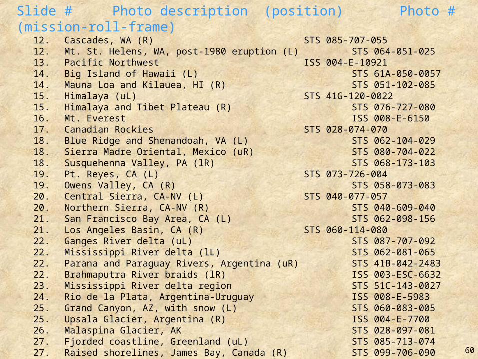
Slide # Photo description (position) Photo # (mission-roll-frame) 12. Cascades, WA (R) STS 085-707-055 12. Mt. St. Helens, WA, post-1980 eruption (L) STS 064-051-025 13. Pacific Northwest ISS 004-E-10921 14. Big Island of Hawaii (L) STS 61A-050-0057 14. Mauna Loa and Kilauea, HI (R) STS 051-102-085 15. Himalaya (uL) STS 41G-120-0022 15. Himalaya and Tibet Plateau (R) STS 076-727-080 16. Mt. Everest ISS 008-E-6150 17. Canadian Rockies STS 028-074-070 18. Blue Ridge and Shenandoah, VA (L) STS 062-104-029 18. Sierra Madre Oriental, Mexico (uR) STS 080-704-022 18. Susquehenna Valley, PA (lR) STS 068-173-103 19. Pt. Reyes, CA (L) STS 073-726-004 19. Owens Valley, CA (R) STS 058-073-083 20. Central Sierra, CA-NV (L) STS 040-077-057 20. Northern Sierra, CA-NV (R) STS 040-609-040 21. San Francisco Bay Area, CA (L) STS 062-098-156 21. Los Angeles Basin, CA (R) STS 060-114-080 22. Ganges River delta (uL) STS 087-707-092 22. Mississippi River delta (lL) STS 062-081-065 22. Parana and Paraguay Rivers, Argentina (uR) STS 41B-042-2483 22. Brahmaputra River braids (lR) ISS 003-ESC-6632 23. Mississippi River delta region STS 51C-143-0027 24. Rio de la Plata, Argentina-Uruguay ISS 008-E-5983 25. Grand Canyon, AZ, with snow (L) STS 060-083-005 25. Upsala Glacier, Argentina (R) ISS 004-E-7700 26. Malaspina Glacier, AK STS 028-097-081 27. Fjorded coastline, Greenland (uL) STS 085-713-074 27. Raised shorelines, James Bay, Canada (R) STS 099-706-090 28. Iceberg, South Atlantic Ocean STS 048-073-00Q 60

Slide # Photo description (position) Photo # (mission-roll-frame) 29. Lake Poopo, Bolivia, 1990 (L) STS 032-088-069 29. Lake Poopo, Bolivia, 1995 (lR) STS 073-735-047 30. Kara-Bogaz Gol, Caspian Sea, 1995 (L) STS 073-701-033 30. Kara-Bogaz Gol, Caspian Sea, 1985 (lR) STS 51F-040-0064 30. Kara-Bogaz Gol, Caspian Sea, inlet (inset) STS 111-E-5485 31. Dust blow, Mauritania (L) STS 103-734-020 31. Namib Desert, Namibia (R) STS 103-732-005 32. Rio Grande dust plumes, Bolivia ISS 004-715-040 33. coastal dunes, Brazil ISS 007-E-15177 34. Hurricane Claudette, Gulf Coast, TX ISS 007-E-10244 35. Hurricane Isabel ISS 007-E-14750 35. eye of Isabel (inset) ISS 007-E-14745 36. Supercell thunderstorms, Canada (L) STS 064-205-050 36. Monsoonal thunderstorms, Bangladesh & India (R) STS 51F-031-069 37. Oyashio Current sea ice (uL) STS 045-079-00N 37. Cape Hatteras, NC (R) STS 034-083-069 38. Plankton bloom, South Atlantic Ocean (L) STS 088-720-020 38. Algal whitings, Little Bahama Bank (R) STS 088-719-029 39. Great Barrier Reef, Australia (L) STS 046-077-031 39. Bora-Bora, Pacific Ocean (uR) STS 068-258-042 40. Maldives, Indian Ocean STS 056-152-160 41. Fires, sediment plumes, Borneo (L) STS 093-708-062 41. Radial deforestation, Tierras Bajas, Bolivia (R) ISS 002-ESC-5654 42. Deforestation, Rondonia Brazil, 1985 (L) STS 51G-034-060 42. Deforestation, Rondonia, Brazil, 1992 (R) STS 046-078-026 43. Betsiboka River delta, Madagascar, 1983 (lL) STS 007-003-058 43. Betsiboka River delta, Madagscar, 2001 (uR) ISS 003-ESC-5073 44. Etosha Pan, Namibia-Angola STS 51G-046-078 45. Egypt-Israel border (L) STS 111-712-008 45. USA (CA)-Mexico border (R) STS 111-E-5224 61

Slide # Photo description (position) Photo # (mission-roll-frame) 46. Aral Sea, 1985 (L) STS 051F-036-059 46. Aral Sea, 1992 (R) STS 047-079-083 47. Aral Sea, bisected, 2002 STS 112-703-157 48. Pivot irrigation, Saudi Arabia STS 083-747-033 49. Mono Lake, Sierra Nevada, CA (L) STS 41G-044-019 49. Las Vegas area, NV (R) STS 073-706-020 50. Lake Powell, UT-AZ ISS 003-E-7751 50. Glen Canyon Dam (inset) ISS 006-E-28359 51. agricultural landscape, Uzbekistan STS 111-340-017 52. St. Louis area, MO (L) STS 062-081-002 52. Yellow River, NW China (R) STS 068-239-083 53. Po River Valley smog, Italy (uL) NASA 6-703-044 53. Smog layer, Upstate NY (lR) STS 092-713-032 54. southern California wildfires, 2003 ISS 007-E-18088 55. Galapagos Islands, Pacific Ocean (uL) STS 099-753-032 55. Manicouagan Reservoir, Quebec (uR) STS 099-749-063 56. Laguna Superior, Mexico (lL) STS 107-E-5180 56. Tokyo Harbor, Japan (lC) STS 107-E-5240 56. Dhaulagiri Himal, Nepal (lR) STS 107-E-5308 57. STS 109 (Space Shuttle) landing KSC 02PD-0264 58. “Blue Marble”, whole Earth (R) AS 17-148-22721
Position of Photograph on the Slide:L = left; R = right; uL = upper left; lL = lower left; uR = upper right; lR = lower right;
C = center; inset = within other photo; lC = lower center
62