DULVERTON TOWN WEIR, EXMOOR HER MEM 21943 Historical ...
26
DULVERTON TOWN WEIR, EXMOOR HER MEM 21943 Historical research, recording and assessment PROJECT REPORT By Hazel Riley
Transcript of DULVERTON TOWN WEIR, EXMOOR HER MEM 21943 Historical ...

DULVERTON TOWN WEIR, EXMOOR HER MEM 21943Historical research, recording and assessment
PROJECT REPORT
By Hazel Riley

DULVERTON TOWN WEIR, EXMOOR HER MEM 21943Historical research, recording and assessment
PROJECT REPORT
By Hazel Riley
Hazel Riley BA (Hons), ACIFA, FSAConsultant in Landscape History, Management and Conservation Grazing
The Furley Herd of Dexter CattleNew House Cottage
FurleyAxminster
DevonEX13 7TR
01404 [email protected]
Date of report: November 2015Copyright: © The author

Dulverton weir
CONTENTSABBREVIATIONSLIST OF FIGURES AND IMAGE ACKNOWLEDGEMENTSABSTRACTADMINISTRATIVE INFORMATIONINTRODUCTIONLocation, topography and geologyAdministrative information and archive arrangementsHISTORICAL BACKGROUNDThe medieval and post-medieval evidenceDulverton weir in the 20th and 21st centuriesPREVIOUS ARCHAEOLOGICAL WORKFIELD ASSESSMENT AND RECORDINGSurvey methodDescription of the weirEVIDENCE FOR THE STRUCTURE AND DATE OF HISTORIC WEIRSCONCLUSIONS AND RECOMMENDATIONSACKNOWLEDGEMENTSREFERENCES
OASIS PROJECT NO 233630
ABBREVIATIONSENPA Exmoor National Park AuthorityDWLCG Dulverton Weir and Leat Conservation GroupGPS Global Positioning SystemHER Historic Environment Record

Dulverton weir
LIST OF FIGURES AND IMAGE ACKNOWLEDGEMENTSThe author wishes to thank the following for permission to reproduce their material. Any infringement of copyright is entirely accidental: every care has been taken to contact or trace all copyright owners. The author would be pleased to correct any errors or omissions brought to her attention.
Somerset Archives and Local Studies Service, South West Heritage Trust Figures 3,4,6,7,8,9,10West Somerset Photographic Archive, West Somerset Rural Life Museum, Allerford Figure 13Exmoor National Park Authority Figure 17
Front cover Dulverton weir from the SW (Hazel Riley)Frontispiece Early 19th-century crepe factory, now Dulverton Laundry (Hazel Riley)Figure 1 Location map (© Crown copyright and database rights 2015 Ordnance Survey) Figure 2 Location and topography (© Crown copyright and database rights 2015 Ordnance Survey)Figure 3 Extract from a map of 1790 showing ‘The Ware’ (SRO DD/X/DL 1/1) (Somerset Archives and Local Studies Service, South West Heritage Trust)Figure 4 Map of Dulverton town 1790 SRO DD/X/DL 1/1) (Somerset Archives and Local Studies Service, South West Heritage Trust)Figure 5 Paper Mill House: an 18th-century mill building (Hazel Riley)Figure 6 Extract from 1820 map of Dulverton town showing site of paper mill, south end of weir and beginning of leat (SRO/DD/X/DL 1/2) (Somerset Archives and Local Studies Service, South West Heritage Trust)Figure 7 Extract from 1820 map of Dulverton parish showing the weir (SRO/DD/X/DL 1/2) (Somerset Archives and Local Studies Service, South West Heritage Trust)Figure 8 Extract from 1820 map of Dulverton town: Town Mills (SRO/DD/X/DL 1/2) (Somerset Archives and Local Studies Service, South West Heritage Trust)Figure 9 Extract from 1820 map of Dulverton town: Lower Mill (SRO/DD/X/DL 1/2) (Somerset Archives and Local Studies Service, South West Heritage Trust)Figure 10 Extract from the tithe map of Dulverton (1838), showing the weir with a single island (SRO D/D/Rt/M/274) (Somerset Archives and Local Studies Service, South West Heritage Trust)Figure 11 Extract from 1st edition map (1889)Figure 12 Extract from 2nd edition map (1902)Figure 13 The weir c 1930 (West Somerset Photographic Archive, West Somerset Museum Rural Life, Allerford)Figure 14 Plan of Dulverton weir, October 2015Figure 15 The fish pass and stepped masonry section of the weir (Hazel Riley)Figure 16 The stepped masonry section of the weir (Hazel Riley)Figure 17 The weir in 2010 showing stepped masonry section in centre, boulders of the fish pass at NE end and concrete capped historic weir to the SW (ENPA 2010 air photograph)Figure 18 The historic weir: 1m scale on section A (Hazel Riley)Figure 19 Section A of historic weir from west (downstream) side (1m and 0.5m scales) (Hazel Riley)

Figure 20 Upright stone slabs at the front of the weir (0.5m scale) (Hazel Riley)Figure 21 Stone slabs at foot of weir below the water level (1m scale) (Hazel Riley)Figure 22 Section B of the historic weir structure. 1m scale is by the front face formed of upright stone slabs (Hazel Riley)Figure 23 Upright stones forming the front face of the historic weir, section B (1m scale) (Hazel Riley)Figure 24 Six wooden stakes in the weir structure (Hazel Riley)Figure 25 Detail of three of the stakes (0.5m scale) (Hazel Riley)Figure 26 Oak stake found on the weir surface (0.5m scale) (Hazel Riley)Figure 27 Looking SW down the weir pool with the island to the right (Hazel Riley)Figure 28 Swete’s ‘Bapel’s Bridge’ 1796 showing a weir for a grist mill on the River Kenn (Gray 1999, 23)Figure 29 The historic weir and the island (Hazel Riley)
Dulverton weir
Frontispiece Early 19th-century crepe factory, now Dulverton Laundry (Hazel Riley)

ABSTRACTAn assessment of the structures which make up Dulverton weir, together with research into its history, has shown that there was a weir on the site since at least as early as the mid- 16th century. There is the potential for the survival of more of the historic weir in an area known as ‘the island’. The work has also highlighted the history of the mill buildings at Dulverton and suggests several areas where further research and survey is needed.
INTRODUCTIONAn assessment and photographic recording of the historic fabric of Dulverton weir was required by the ENPA Historic Environment Team, following recent storm damage and repairs to the weir (Riley 2015).
Location, topography and geologyThe weir at Dulverton, also known as the ‘Town Weir,’ runs NE/SW across the River Barle on the northern edge of the town, opposite Weir View House and Weir Head Cottages on Northmoor Road, centred at SS 9138 2833 (Fig 1). Here, the Barle lies in a deeply incised, meandering valley, with Burridge Wood to the west and Weir Cleeve to the east. The river has cut through Devonian Sandstones of the Pickwell Down Formation; the valley floor is occupied by Quaternary alluvial deposits (bgs.ac.uk). It is some 100m wide, with pasture and meadows on the west bank and Northmoor Road and houses in small plots in the narrow strip of level ground on the east bank (Fig 2).
Administrative information and archive arrangementsNGR: SS 9138 2833 Parish: Dulverton District: West Somerset County: SomersetExmoor HER: MEM 21943A CD containing the photographic record, index and digital copies of the report has been deposited with the Exmoor HER.
Fig 1 Location map
Dulverton weir1
Dulverton weir
© Crown copyright and database rights 2015 Ordnance Survey

HISTORICAL BACKGROUNDThe weir at Dulverton was constructed to channel water from the River Barle into a leat which provided power for several mills in the town until the 1970s. The history of the weir at Dulverton is therefore connected with the history of the mills in the town and the following account, which draws on documents and maps held primarily at the Somerset Heritage Centre, Taunton, refers to both the weir and the mills.
The medieval and post-medieval evidenceThe manor of Dulverton was held by Nicholas de Boneville and his wife, Hawasia, in the early 14th century. Following her death, an inquisition taken at Dulverton in 1331 gives the earliest known evidence for a mill in the manor of Dulverton. The manor had been divided into three and the inquisition details it in two parts: two-thirds which had belonged to the Crown at various times, and the third which was Hawasia’s dowry. Taken together it is clear that there was a water mill in the manor of Dulverton in 1331, worth a total of 15 shillings:
The said two parts were worth 73 shillings and fourpence; there were 200 acres of hill land, of which some 40 acres could be sown with oats, worth three halfpence per acre, and the remaining 160 acres were worth nothing. Other acres of meadow were worth 12 pence, and two parts of a water mill were worth ten shillings....The value [of the final third of the manor] was 15 shillings and sixpence, with 100 acres of hill land, of which 20 acres could be sown with oats, worth three halfpence per acre, and the remaining 80 acres were worth nothing, being in common. There were two acres of meadow, at 12 pence each, a third of a mill, worth five shillings....(Green 1883, 71-72)
Fig 2 Survey location and topography
Dulverton weir2
Dulverton weir
© Crown copyright and database rights 2015 Ordnance Survey

Although this 14th century reference to a water mill can only be located to the manor of Dulverton, a grant of the manor in 1556 suggests that the mill may well be in the town of Dulverton and that the weir was in existence at, or close to, its current location by this time:
[The manor of Dulverton] was granted, with Thurloxton, for the sum of £1230 5s, duly paid, to William Babington, a gentleman of the Privy Chamber, with all courts, liberties, etc., and all the woods known as Marshwood, Alchutwood, and Wareclywood...(Green 1883, 75)
‘Wareclywood’ is now Weir Cleeve; the name has been associated with the woods to the NE of the weir since at least as early as the 18th century, when it was known as ‘Warecliff ’ (SRO DD/X/DL 1/1; SRO A\AHT/174/3). By the middle of the 19th century it was known as ‘Weare Cleeve’ (Dulverton tithe map and apportionment 1838).
William Babington sold Dulverton manor to John Sydenham in 1568 when it was declared to consist of:
Eighty messuages, 20 cottages, 20 tofts, six mills, six dovecotes, 80 gardens, 30 orchards, 2000 acres of land, 100 acres of meadow, 200 acres of pasture, 300 acres of wood, 200 acres of gorse and heath, 100 acres of woodland, and 100 shillings of rent in Dulverton, Pyxton and Combe.(Green 1883, 75).
The context of this reference suggests it includes properties in the town of Dulverton and that the six mills may well have been within the town. Several leases from the 17th century affirm this. Humfrey Sydenham’s deed of entail to trustees for his sons of the Manors of Dulverton, Brushford Sydenham and Chubworthie and a moiety of the Manor of East Anstey, the capital messuage called Combe in Dulverton, the Town Mills in Dulverton and lands in Dulverton and Brushford is dated 1606 (SRO A\AHT 1/1, 1/2).
The name ‘Town Mills’ for the Dulverton manor mills persists throughout the 17th century. John Sydenham’s deed to raise £2000 for his sons and daughters, involving the Manor of Brushford, a moiety of the Manor of East Anstey, the capital messuage called Combe, the Town Mills and a fulling mill, all in Dulverton, dates from 1638 and is one of the earliest references to a textile mill in the town (SRO A\AHT 1/7). A deed from 1664 appears to be the first time that the Dulverton mills are specified as corn mills. This is a copy settlement by George Sydenham of Combe which includes the phrase ‘the water grist mills in or near the town of Dulverton’ (SRO DD\BR\dw/1).
The references to six mills do not, however, mean that there were six separate mill buildings in Dulverton manor. There were two water wheels at the Dulverton Town Mills and Watts has pointed out that:
Dulverton weir3
‘Where more than one mill was recorded at apparently the same location, it is probable that more than one waterwheel was used. There is no evidence that Domesday waterwheels, whether vertical or horizontal, drove more than a single set of millstones, and the term ‘mill’ therefore described one milling unit, comprising a waterwheel and a single pair of millstones. It is quite likely that two or more such units were sometimes housed in a single building and were served by the same watercourse. In later medieval documents references to ‘two mills under one roof ’ frequently occur, and there are many surviving examples of this arrangement’(Watts 2000, 19).
Historical research has shown that southern Exmoor was growing wealthier in the 16th century, and that sheep were an important part of the local economy by this time. By the early part of the 16th century wool was being made into cloth locally at towns such as North Molton and Dulverton (Siraut 2009, 75-6). By 1532, Dulverton church had a chapel dedicated to St Blaise, the patron saint of wool-combers, and Richard Skinner, a clothier from Dulverton, marketed cloths at St James’s Fair, Bristol, in the 16th century. Weaving was carried out in Brushford and Exebridge in the early 17th century, and the Sydenham family owned a fulling mill in Dulverton in 1638 and three by 1654 (Siraut 2009, 77). The mills in Dulverton were evidently an important source of income and a 17th-century document records that the Dulverton Town Mills were worth £40 annually (SRO DD\SF/5/6/3).
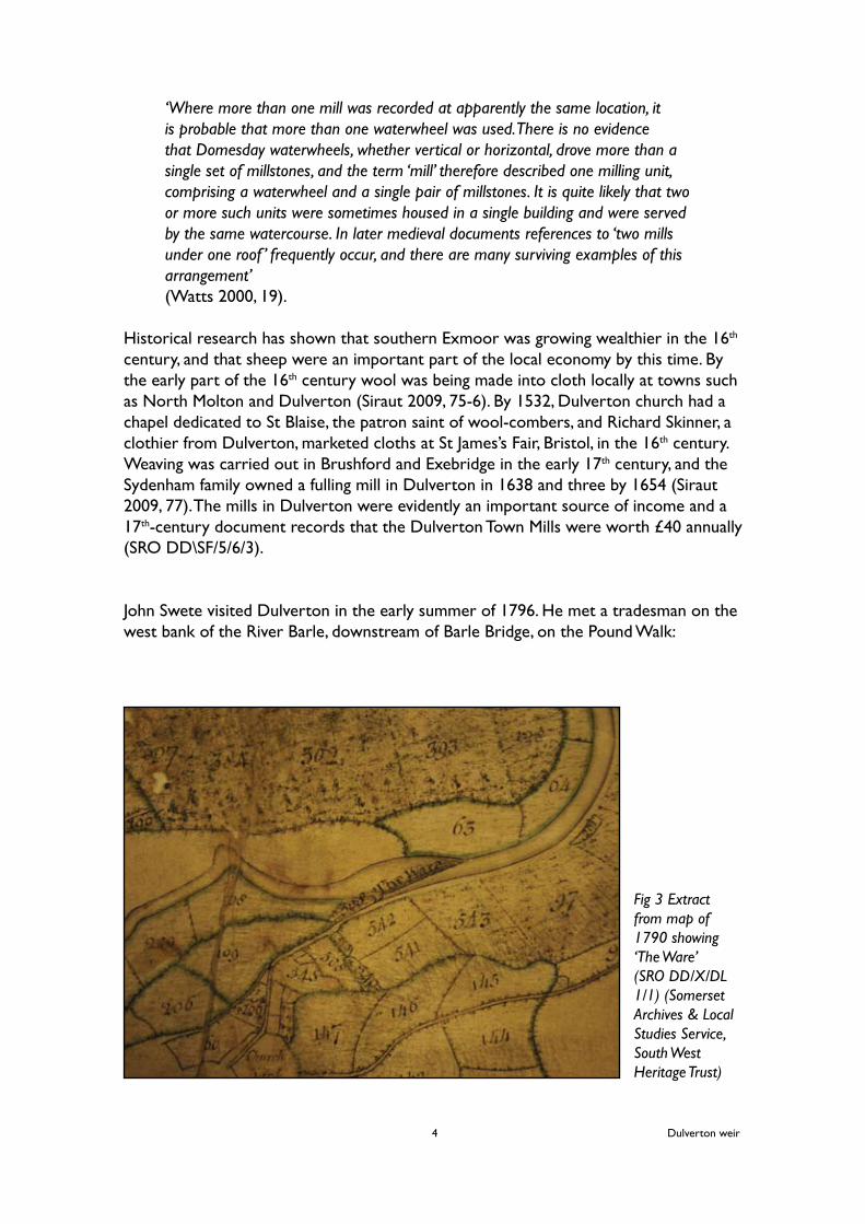
John Swete visited Dulverton in the early summer of 1796. He met a tradesman on the west bank of the River Barle, downstream of Barle Bridge, on the Pound Walk:
Fig 3 Extract from map of 1790 showing ‘The Ware’ (SRO DD/X/DL 1/1) (Somerset Archives & Local Studies Service, South West Heritage Trust)
Dulverton weir4

In the course of conversation, I gathered that the town had once been in the possession of a good clothing manufacture, which has now fallen into decay - and he pointed out to me on the opposite banks of the river several fulling Mills, which were become ruins(Gray 1999, 57)
A map of the Sydenham’s Dulverton possessions in 1790 is the first time that Dulverton’s weir and mills are placed in the townscape (SRO DD/X/DL 1/1). The weir is shown in the same location as the present day structure, running across the River Barle with an overflow or sluice at its south end. It is called ‘The Ware’ and this name is written across the structure which is shown as a straight line – perhaps the edge of a stone wall– with some shading which could represent the width of the weir or stonework (Fig 3). The relationship between the leat and the weir is not clear on this map, but it probably flowed along the edge of Northmoor Road which was known as the Strand at this time. The leat is shown clearly as a channel which begins at Papermill House (below).
The detailed plan of Dulverton town which forms part of the 1790 survey shows individual building and building plots and further study of this map and the book of reference is needed to clarify the location and function of the mills in the town at this time. The building now called ‘Town Mills’ is clearly shown, and Lower Mill and the leat outfall into the Barle are also depicted (Fig 4).
Papermill House is clearly shown on the 1790 map as a narrow rectangular building in a plot between Northmoor Road and the leat (Fig 4). Part of the former mill building survives (32 Northmoor Road). It is three-storey, built of stone rubble with timber lintels and small casement windows and probably dates from the 18th century (ENPA 2014, 57) (Fig 5).
Fig 4 Map of Dulverton town 1790 (SRO DD/X/DL 1/1) (Somerset Archives & Local Studies Service, South West Heritage Trust)
Dulverton weir5

Very little is known about the paper mill at Dulverton. Manuscript notes for a study of the paper mills of Somerset refers to ‘Paper Mill House 1818’ and the reference book for the 1820 map of Dulverton (below) shows four buildings on this plot, all under the heading ‘Paper Mill’, with the earliest building clearly shown as plot 295 (Fig 6) (SRO A/CKN/ 7/9; DD/X/DL 1/2 & 1/3). The surviving structure is clearly an important part of the history of Dulverton’s mills and further study of both the surviving fabric and documentary evidence is needed.
The map of the manor of Dulverton in 1820 depicts the town in considerable detail, with its surroundings at a smaller scale. Unluckily, the edge of the detailed town plan ends at the weir, although it does show the beginning of the leat at the south end of the weir (Fig 6). The smaller scale parish map shows the weir as a single scalloped line (Fig 7). The town plan graphically shows the location of two mills – now known as Town Mills and Lower Mill - in the town by the device of drawing a water wheel across the leat (Figs 8 & 9). In the book of reference the mills are called ‘Manor Mills,’ suggesting that they were all under the same ownership at this time. Fig 5 (below left) Paper Mill House: 18th-century mill building (Hazel Riley)Fig 6 (Below right) Extract from 1820 map of Dulverton town showing the paper mill (295), south end of weir and beginning of leat (SRO DD/X/DL 1/2) (Somerset Archives & Local Studies Service, South West Heritage Trust)Fig 7 (bottom right) Extract from 1820 map of Dulverton parish showing the weir (SRO DD/X/DL 1/2) (Somerset Archives & Local Studies Service, South West Heritage Trust)
Dulverton weir6

Henry Smith, owner of a large silk manufacturing family business with factories in London and Taunton, built a crepe (a type of silk) factory near Lower Mills in Dulverton in the 1820s. Crepe was a fashionable black cloth, made by applying gum to the silk during dyeing. This building, which reflected some of the latest principles of factory design in the 1820s, now houses the Dulverton Laundry (Frontispiece). Its stone pier and panel construction provided a high level of natural light and an external wheelhouse, supplied by the town leat, enabled an efficient layout of machinery. An inventory of 1859 suggests that the ground floor housed 11 power looms, with up to 70 workers.
By the 1870s silk was no longer made at Dulverton and the building was converted to a laundry in the 1890s (Williams 2013, 170-1). By 1861 Robert Warren was the miller at Town Mills and Henry Scott ran the grist mill at Lower Mill (Binding and Bonham-Carter 1986, 28).
The tithe map (1838) shows the weir as a functioning structure: a straight line runs across the back of the weir, channelling water into the leat. A sluice is marked across the leat and an overflow channel is clearly marked at the south end (Fig 10). Blue lines indicate water flowing across the weir and an island in front is the forerunner of the five small islands shown on the 1st edition map (Fig 11).
Dulverton weir7
Figs 8 (left) Extract from 1820 map Dulverton town: water wheel marks Town Mills (SRO DD/X//DL 1/2) (Somerset Archives & Local Studies Service, South West Heritage Trust)
Fig 9 (below left) Extracts from 1820 map Dulverton town: water wheel marks Lower Mills (SRO DD/X//DL 1/2) (Somerset Archives & Local Studies Service, South West Heritage Trust)
Fig 10 (below) Dulverton tithe map 1838 (SRO D/D/Rt/M/274) (Somerset Archives & Local Studies Service, South West Heritage Trust)

Fig 11 (top) Extract from OS 1st edition map (1889)Fig 12 (above) Extract from OS 2nd edition map (1902)
Dulverton weir8

The detailed map depiction on the OS 1st edition shows that the weir was some 120m long, running NE/SW across the River Barle by the late 19th century. The northern part is a regular structure, built in 11 rectangular sections, with what appears to be a narrow wall on the upstream side. The southern section is shown as an earthwork forming the west side of the leat channel (Fig 11).
Dulverton weir in the 20th and 21st centuriesThe OS 2nd edition map of 1902 shows that the leat has been modified since the 1889 map – this is probably a phase of repair and rebuilding. A narrow wall lies on the upstream side of a structure built of 23 sections, some 95m long, 5m wide with a sluice to the south (Fig 12). A photograph taken in the early 20th century shows the weir from the downstream side. Lines of vegetation suggest that the sectional construction shown on the OS maps and the figure gives an idea of the height of the weir: about 1.5m (Fig 13).
The leat was used to supply water to theTown Mills well into the 20th century and the owners of the Town Mills were responsible for the repair and maintenance of the weir and leat. Lower Mill was a grist mill in the 1920s and 1930s, and theTown Mills continued milling corn for animal feed until 1972 (Binding and Bonham-Carter 1986, 38-9). Dulverton Laundry stopped using water power in 1935, but the leat still provides a source of water for the business.
A short film - The Big Freeze 1940 - by Barle Films (viewed at the Dulverton Heritage Centre, 30th October 2015) shows skaters on the frozen river at Weirhead during the extreme cold winter of 1940. The floods which devastated Lynton and Lynmouth in August 1952 also affected the Barle and Exe Valleys. In Dulverton the Barle Bridge was blocked with a mass of large trees and brushwood and quantities of boulders and debris were deposited on the town’s allotments which occupied the valley floor
Dulverton weir9
Fig 13 The weir c 1930 (West Somerset Photographic Archive, West Somerset Museum Rural Life, Allerford)

between the weir and Exmoor House. The clearance operations were reported in some detail but no mention was made of the weir (SRO C/6/1/9).
The history of the weir in the late 20th and 21st centuries is set out by the Dulverton Weir and Leat Conservation Group (DWLCG) in some detail in their report on Dulverton Weir (2015) and this account draws heavily on this work which is gratefully acknowledged here.
A fish pass at the NE end was rebuilt in 1993 following the collapse of a section of the weir. This had caused water levels in the leat to fall so that Dulverton Laundry was unable to extract water. The 1993 fish pass is built of boulders from the river bed, laid along the base of the historic weir (DWLCG 2015, 16). In 1995 some 12.7m of the weir was repaired using stepped mortared sandstone over a core of river gravel (DWLCG 2015, 10-11). About 7m of the SW end of the weir and the spillway was reconstructed when the sluice into the leat was rebuilt c 1999 (DWLCG 2015, 17). A further 9.5m of the weir was repaired using stepped mortared sandstone over a core of river gravel in 2000. Photographs show how part of the remaining historic structure was removed as part of this repair (DWLCG 2015, 12-13). The spillway was reconstructed in 2011; the work was repeated in 2012 due to the failure of the 2011 repairs (DWLCG 2015, 17).
Flooding of the River Barle in December 2012 caused two breaches in the crest of the weir; these breaches widened as water flow washed out the exposed weir structure. Sand-filled ‘dumpy’ bags were placed in these breaches sometime between March 2013 and August 2014, but the river quickly washed them away (DWLCG 2015, 1). A repair was made using rock-filled gabions (large wire baskets) behind some 34m of the front face of the weir in order to raise the water level in the weir pool in August 2014 (DWLCG 2015, 18). The breach was infilled with stone but most of this has since been washed away. During this work about 45 oak stakes were recovered from the weir structure and were the subject of a dendrochronological study (below).
PREVIOUS ARCHAEOLOGICAL WORKThe DWLCG have been working on Dulverton weir for several years. The results of their work, including several 19th- and early 20th-century photographs and photographs of various re-building episodes, are set out in a report on the history, structure and condition of Dulverton weir (DWLCG 2015).
During the 2014 work on the weir, about 45 oak stakes were recovered from the weir structure and the DWLCG commissioned a dendrochronological study of the timber. The resulting chronology spanned the years between 1717 and 1803 for felling dates of the timber and the report suggests that these stakes were from two phases of repair to the weir, in c AD 1784 and c AD 1803 (Moir 2014). Interestingly, this is the very time that we have contemporary accounts of Dulverton as a manufacturing town in decay, with several ruined fulling mills on the east bank of the Barle (Gray 1999, 57).
Dulverton weir10

FIELD ASSESSMENT AND RECORDINGThe fieldwork was carried out on 17th October 2015 when the river level was low enough to allow access across the spillway onto the SW end of the weir. The aim was, as far as safety concerns would allow, to obtain a photographic and descriptive record of the weir, with a particular focus on the surviving historic fabric, and to record the approximate locations of the main aspects of the historic weir structure.
Survey methodFeatures were located using Trimble’s Yuma 2 tablet PC with enhanced GPS reception via Korec K-Mobile software. These features were plotted onto a rectified air photograph of the area taken in 2010. The parts of the weir which were inaccessible were plotted from this air photograph and additional information was provided from the OS 1: 2500 scale Mastermap. The resulting 1: 1000 plan shows the main components described below, together with the areas for potential for the survival of the historic weir structure (Fig 14). A photographic record of the site was undertaken.
Description of the weirThe weir runs NE/SW from the west bank of the River Barle, opposite Weir View House, for some 120m to the sluice and footbridge at its SW end, where water is taken off to the leat. There are several components within the structure.
The fish passAt the NE end a fish pass, c 14m long and 6m wide, constructed of boulders in 1993, is visible but access to it was not possible (Fig 15)
The stepped masonry section of the weirSome 24m of the weir were rebuilt with sandstone blocks over a stone rubble core in 1995 and 2000. The masonry is visible but access to it was not possible (Figs 16 & 17).
Fig 15 The fish pass and stepped masonry section of the weir (Hazel Riley)
Dulverton weir11

Fig 14 Plan of Dulverton weir, October 2015
Dulverton weir12
291400
128400
128300
0 25m
Weirhead Cottages
Weir View House
Spillway
Sluice
Fish pass
Stepped masonry weir
The island
A
BOak stakes
Wei
rpo
ol
Rive
r Bar
le
Hist
oric
wei
r
Tow
nle
at
Nor
thm
oor
Road
© Crown copyright and database rights 2015 Ordnance Survey 100024878

The historic weir Some 20m of the structure, between the island and the SW end of the stepped masonry weir, is built of stone which has been capped with concrete in places. This capping has failed in a number of places. Several wooden stakes are visible towards the front of the structure when the river level is low and structural features within the stonework are visible. A well preserved section of the weir at the NE end of the island is some 4.4m NE/SW by 5m NW/SE (Fig 14, A; Fig 18). It comprises a sloping embankment of carefully placed water worn cobbles which probably originated from the river bed (Fig 19). Large upright stone slabs form the front face of the weir (Fig 20).
Dulverton weir13
Fig 16 (above) Stepped masonry section of the weir (Hazel Riley)Fig 17 (above right) The weir in 2010: stepped masonry section in centre, fish pass to top and historic weir above the island (ENPA)Fig 18 (right) The historic weir (1m scale on section A) (Hazel Riley)Fig 19 (bottom right) Section A of the historic weir from the west (downstream) side (1m & 0.5m scales) (Hazel Riley)Fig 20 (below) Upright stones at the front of the weir (0.5m scale) (Hazel Riley)

At the foot of the weir some carefully placed stone slabs are visible below the water level (Fig 21).
To the NE of a substantial breach in the weir is a further section of well preserved historic weir (Fig 14, B). It is 10m NE/SW by 5-7m NW/SE and is mostly capped with concrete but where this has failed details of the historic structure are visible (Fig 22). Several upright stones are probably part of the historic weir structure and would correspond with its depictions on the OS 1st and 2nd edition maps (Figs 23; 11 & 12).
Fig 21 (above) Stone slabs at foot of weir below water level (1m scale) (Hazel Riley)
Fig 22 (above left) Section B of historic weir. 1m scale by upright stones of front face (Hazel Riley)
Fig 23 (below) Upright stones forming front face of historic weir, section B (1m scale) (Hazel Riley)
Fig 24 (left) Six stakes in the historic weir (Hazel Riley)
Dulverton weir14
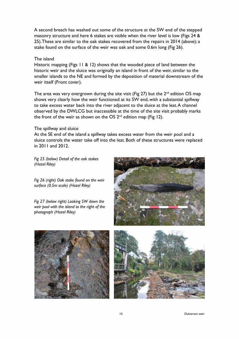
A second breach has washed out some of the structure at the SW end of the stepped masonry structure and here 6 stakes are visible when the river level is low (Figs 24 & 25). These are similar to the oak stakes recovered from the repairs in 2014 (above); a stake found on the surface of the weir was oak and some 0.6m long (Fig 26).
The islandHistoric mapping (Figs 11 & 12) shows that the wooded piece of land between the historic weir and the sluice was originally an island in front of the weir, similar to the smaller islands to the NE and formed by the deposition of material downstream of the weir itself (Front cover).
The area was very overgrown during the site visit (Fig 27) but the 2nd edition OS map shows very clearly how the weir functioned at its SW end, with a substantial spillway to take excess water back into the river adjacent to the sluice at the leat. A channel observed by the DWLCG but inaccessible at the time of the site visit probably marks the front of the weir as shown on the OS 2nd edition map (Fig 12).
The spillway and sluice At the SE end of the island a spillway takes excess water from the weir pool and a sluice controls the water take off into the leat. Both of these structures were replaced in 2011 and 2012.
Dulverton weir15
Fig 25 (below) Detail of the oak stakes (Hazel Riley)
Fig 26 (right) Oak stake found on the weir surface (0.5m scale) (Hazel Riley)
Fig 27 (below right) Looking SW down the weir pool with the island to the right of the photograph (Hazel Riley)
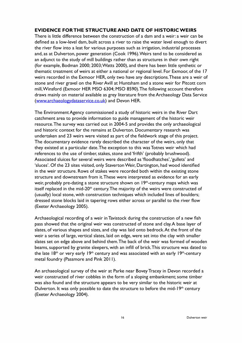
EVIDENCE FOR THE STRUCTURE AND DATE OF HISTORIC WEIRSThere is little difference between the construction of a dam and a weir: a weir can be defined as a low-level dam, built across a river to raise the water level enough to divert the river flow into a leat for various purposes such as irrigation, industrial processes and, as at Dulverton, power generation (Cook 1996). Weirs tend to be considered as an adjunct to the study of mill buildings rather than as structures in their own right (for example, Bodman 2000; 2003; Watts 2000), and there has been little synthetic or thematic treatment of weirs at either a national or regional level. For Exmoor, of the 17 weirs recorded in the Exmoor HER, only two have any descriptions. These are a weir of stone and river gravel on the River Avill at Huntsham and a stone weir for Pitcott corn mill, Winsford (Exmoor HER MSO 6304; MSO 8590). The following account therefore draws mainly on material available as grey literature from the Archaeology Data Service (www.archaeologydataservice.co.uk) and Devon HER.
The Environment Agency commissioned a study of historic weirs in the River Dart catchment area to provide information to guide management of the historic weir resource. The survey was carried out in 2004-5 and provides the only archaeological and historic context for the remains at Dulverton. Documentary research was undertaken and 23 weirs were visited as part of the fieldwork stage of this project. The documentary evidence rarely described the character of the weirs, only that they existed at a particular date. The exception to this was Totnes weir which had references to the use of timber, stakes, stone and ‘frifth’ (probably brushwood). Associated sluices for several weirs were described as ‘floodhatches’, ‘gullets’ and ‘sluces’. Of the 23 sites visited, only Staverton Weir, Dartington, had wood identified in the weir structure. Rows of stakes were recorded both within the existing stone structure and downstream from it. These were interpreted as evidence for an early weir, probably pre-dating a stone structure shown on 19th-century maps which was itself replaced in the mid-20th century. The majority of the weirs were constructed of (usually) local stone, with construction techniques which included lines of boulders; dressed stone blocks laid in tapering rows either across or parallel to the river flow (Exeter Archaeology 2005).
Archaeological recording of a weir in Tavistock during the construction of a new fish pass showed that the original weir was constructed of stone and clay. A base layer of slates, of various shapes and sizes, and clay was laid onto bedrock. At the front of the weir a series of large, vertical slates, laid on edge, were set into the clay with smaller slates set on edge above and behind them. The back of the weir was formed of wooden beams, supported by granite sleepers, with an infill of brick. This structure was dated to the late 18th or very early 19th century and was associated with an early 19th-century metal foundry (Passmore and Pink 2011).
An archaeological survey of the weir at Parke near Bovey Tracey in Devon recorded a weir constructed of river cobbles in the form of a sloping embankment; some timber was also found and the structure appears to be very similar to the historic weir at Dulverton. It was only possible to date the structure to before the mid-19th century (Exeter Archaeology 2004).
Dulverton weir16

A further source for the character of historic weirs which has been largely neglected are paintings and prints, in particular the collection of watercolours by William Payne (Devon Local Studies Library www.devon.gov.uk/localstudies) and John Swete (Gray 1997; 1998; 1999; 2000). Rivers and picturesque mill buildings were favoured subjects and William Payne’s painting of Staverton Weir shows a stone weir with wooden stakes below it, suggesting that the stakes had been replaced by a stone structure by the later 18th century. John Swete usually painted rivers in full flow, so that most of his studies of weirs have the appearance of small waterfalls. Dunsford Mill Weir is described as ‘divided ledges of stones rudely piled’, and a painting of the weir at Otterford clearly shows a stone weir with the mill leat behind (Gray 1998, 42). Another of Swete’s watercolours shows a weir constructed of stones and wooden stakes at Bapel’s Bridge on the River Ken – this is dated 1796 and appears to be very similar to the surviving historic fabric at Dulverton. The weir on the River Ken supplied water for a grist mill in use in the late 18th century (Gray 1999, 23) (Fig 28). Weirs and mills were constructed during the summer months when water levels were low. A document from the 11th century which outlines the duties of a reeve instructs that ‘in May and June and July, in summer, one may....construct a fish-weir and a mill’ (quoted in Watts 2000, 20). This early reference to a fish weir is significant here. There is a long history of the use of wooden stakes, together with stones, to form fish weirs on the West Somerset coast and in the Severn Estuary. Some of the timbers have dates which place the structures in the early medieval period, and sites on the Severn have associations with medieval monasteries (Pannett 1988; Godbold and Turner 1994). It may be that the antecedents of weirs for mill leats may be seen in these ancient fish weirs. Certainly some excavated evidence suggests this. A 12th-century mill dam and timber waterwheel race were found at Hemington Fields in Leicestershire during gravel extraction in 1985. The dam, which probably originated as a fish weir, was constructed of two rows of oak posts with hazel wattles between them supporting a core of stone, gravel and brushwood, and was used to direct water into a mill race. A 19th-century stone and concrete weir at Fleet Mills in West Yorkshire, where mills have been recorded from the 13th century, contained a succession of timber structures on different alignments. These were timber box-framed structures with vertical boards forming the back of the weir which were held in place by carefully laid stones (Watts 2000, 20-21).
Dulverton weir17
Fig 28 Swete’s ‘Bapel’s Bridge 1796, showing a weir for a grist mill on the River Kenn (Gray 1999, 23)

CONCLUSIONS AND RECOMMENDATIONSDocumentary evidence shows that there has been a weir at the Town Weir site since at least as early as the mid-16th century, when the presence of a weir is indicated by a place name. It was a timber and stone structure which was periodically repaired or rebuilt to keep a steady flow of water into the leat which served several grist and textile mills in Dulverton town from the 16th century until the 1970s.
The presence of timber within the stone structure is significant. Dendrochronological dating dated several stakes to the 18th century but the remaining historic weir fabric may well contain much older timbers. The evidence from other historic weirs, both in Devon and elsewhere in England, suggests that post-medieval weirs tended to be constructed of stone with little evidence for timber work.
There has been little study of historic weirs on Exmoor but it is clear that Dulverton weir is a significant survival of a medieval or early post-medieval structure. There are several strands to follow up from this initial assessment:
Dulverton weir1 Vegetation clearance on the island, followed by survey and recording to assess the survival of the historic weir in this area (Fig 29).
2 Large scale survey, including height measurements, of the historic weir to show the extent of the structure and the structural details. Sample areas of the cobbled surface should be recorded stone by stone at large scale.
3 Continued monitoring by the DWLCG including photographs taken from the same viewpoints.
Fig 29 The historic weir and the island (Hazel Riley)
Dulverton weir18

4 Further study – frame by frame – of the films seen in the Dulverton Heritage Centre and Barle Films to ascertain whether the weir can be seen in The Big Freeze 1940, The Flood 1952 and any archive material
Dulverton mills1 Building recording, documentary and cartographic research at Papermill House, Town Mills, the Crepe Factory and Lower Mills.
2 Building recording, documentary and cartographic research for other mill sites identified from 18th and early 19th century sources (SRO DD/X/DL 1/1; DD/X/DL 1/2; DD/X/DL 1/3; A\AHT/174/3; Dulverton tithe map and apportionment D/D/Rt/M/274)
The Somerset Archives and Local Studies Service and the Exmoor Society should be consulted as part of this research.
Exmoor National Park1 Survey and assessment of the historic weirs of Exmoor to enhance the HER and to put the survival of Dulverton weir into a landscape scale context.
ACKNOWLEDGEMENTSThe author would like to thank the landowners - West Somerset Council and Frances Takel - who provied access to the weir site. Staff from the Devon HER kindly allowed access to a draft copy of the survey of historic weirs on the River Dart catchment; Exmoor National Park staff provided background information and images and S Blaylock facilitated the project and helped with the fieldwork. The DWLCG kindly supplied copies of their research material. Staff at the West Somerset Museum of Rural Life, Allerford, facilitated access to material in the West Somerset Photographic Archive.
REFERENCESBinding, H and Bonham-Carter, V 1986 Old Dulverton and AroundBodman, M 2000 West Somerset Mills around Wiveliscombe: watermill sites on the upper River Tone and Hillfarrance BrookBodman, M 2003 Watermills and other water-powered sites in Devon (interim draft)Cook, M 1996 Archaeological Recording at Powick Weir, near WorcesterDulverton Weir and Leat Conservation Group 2015 Dulverton Weir: A Report by the DWLCG on the History, Structure and Condition of Dulverton WeirExeter Archaeology 2004 Archaeological Survey of Parke Weir, Bovey TraceyExeter Archaeology 2005 An Archaeological Survey of Weirs in the River Dart Catchment (Draft available in Devon HER)Exmoor National Park Authority 2014 Dulverton Conservation Area: Appraisal DocumentGodbold, S and Turner, R C 1994 ‘Medieval fishtraps in the Severn Estuary’ Medieval Archaeology 38, 19-54Gray, T 1997 Travels in Georgian Devon The Illustrated Journals of the Reverend John Swete (1789-1800) Vol IGray, T 1998 Travels in Georgian Devon The Illustrated Journals of the Reverend John Swete (1789-1800) Vol II
Dulverton weir19

Gray, T 1999 Travels in Georgian Devon The Illustrated Journals of the Reverend John Swete (1789-1800) Vol IIIGray, T 2000 Travels in Georgian Devon The Illustrated Journals of the Reverend John Swete (1789-1800) Vol IVGreen, E 1883 ‘Notes on the history of Dulverton’ Proc Som Arch Nat Hist Soc 29(2), 69-82Moir, A 2014 Dendrochronological Analysis of Oak Timbers from Dulverton Weir, Northmoor Road, Dulverton, Somerset, EnglandPannett, D J 1988 ‘Fish weirs of the River Severn with particular reference to Shropshire,’ in M Aston (ed) Medieval Fish, Fisheries and Fishponds in England (II), 371-389Passmore, A J and Pink, F 2011 Archaeological Recording at Evans Weir, Parkwood Road, Tavistock, Devon Riley, H 2015 Dulverton Town Weir, Exmoor HER 21943 Historical research, recording and assessment Outline project planSiraut, M 2009 Exmoor: the Making of an English LandscapeSRO A\AHT/1-10 A bundle of Sydenham family settlementsSRO C/6/1/9 Dulverton Storm Damage 15th August 1952SRO A/CKN/ 7/9 Research notes on Dulverton paper mill 1998SRO DD\BR\dw/1 Dulverton and Brushford deedSRO DD\SF/5/6/3 Notes sent by Edward Clarke to John Spreate at Chipley 17th centurySRO DD/X/DL 1/1 A Map of the Manor of Dulverton in the county of Somerset belonging to St B Sydenham Esq by W White, Wedmore 1790SRO DD/X/DL 1/2 Plan A Dulverton Manor (Town) and Plan B Dulverton Manor (Parish) by Charles Chilcott 1820SRO DD/X/DL 1/3 Transcript of a book of reference to the plans marked A and B of all that part of the Manor of Dulverton in the county of Somerset situated on the NE side of the River Barle 1820SRO A\AHT/174/3 Book of reference to the map of the Manor of Dulverton 1790SRO D/D/Rt/M/274 Dulverton tithe map and apportionment, 1838Watt, M 2000 Water and Wind PowerWilliams, M 2013 Textile Mills of South West England
Dulverton weir20