DRC IRAQ Ninewah Multisector Needs...
33
Transcript of DRC IRAQ Ninewah Multisector Needs...
Acknowledgements:
This report was written by Olivia Booth and edited by Ed Hughes, with data analysis by Raul Alfonso Rios.
Survey enumerators: Attaf Ahmad
Azad Mohammad
Chalank Ibrahim
Diyar Ramadan
Hariwan Amir
Karwan Faisal
Zaid Tariq
Focus group facilitators: Attaf Ahmad
Chalank Ibrahim
Karwan Faisal
Duaa Ihsan Abdullah
Abta Salim Ibrahim
Karveen Ibrahim
Hazheen Hamdi Ramadan
Yasser Al-Faris
Attaf Ahmad, Azad Mohammad, Chalank Ibrahim, Diyar Ramadan, Hariwan Amir, Karwan Faisal, and Zaid Tariq also
undertook additional data collection and provided insight and context for this report. DRC is grateful to REACH
for producing the maps included in this report.
This report reflects the analysis of the editor and is not the institutional position of The Danish Refugee Council.
Data, analysis or maps presented herewith are without prejudice to claims and positions of any party, or to the
demarcation of boundaries, names of locations or status of communities.
Photo credits: Front cover: Karwan Faisal / DRC
Page 5: Hariwan Amir / Attaf Ahmad / DRC

The northern region of the Ninewa Governorate, in northwest Iraq, is an ethnically, culturally and religiously diverse. Already one of the poorest and most marginalised parts of the country, the region has been profoundly affected by recent conflict, which has caused mass displacement and disrupted the primarily agrarian economy. Many displaced communities have returned as areas have become accessible, and just over 150,000 people are now living in territory which is now de-facto administered by the Kurdish Regional Government. However, this study shows that conditions for returnees (approximately 80% of the population), as well as for those who are still displaced, are extremely difficult. More than half of the communities in northern Ninewah reported that households were unable to afford basic needs, with most households supporting themselves with savings and borrowed money. Almost 30% reported that no one in the community had earned an income in the last 30 days, with less than half of working-age men in employment. Only 2% of communities reported that households were able to support themselves through income from farming and livestock. Communities consistently prioritised food, medical assistance and water as their most urgent priority needs. The survey also shows that, even where public infrastructure is present, it is not functioning effectively. Almost all communities reported challenges accessing healthcare, with lack of availability of medicines widespread. One in five communities had not been able to access government-provided food assistance in the last two months, and over 75% had experienced daily power shortages, despite being connected to the electricity network. Less than a third of communities had access to network water, and more than half did not have working latrines. 55% of the surveyed communities were Kurdish, 42% were Arabic, and 3% were mixed, and although
the Arab communities tended to report more restrictions on their movement, there were no
significant differences in levels of need. However, there are a significant number of households who
may be particularly vulnerable, with over a quarter of the 25,000 households in the region headed by
women, children, persons with disabilities or elderly persons.
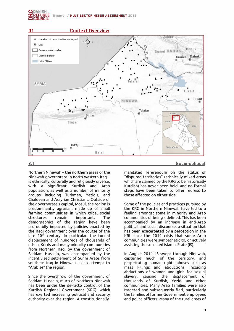
Northern Ninewah – the northern areas of the Ninewah governorate in north-western Iraq – is ethnically, culturally and religiously diverse, with a significant Kurdish and Arab population, as well as a number of minority groups including Turkmen, Yazidis, and Chaldean and Assyrian Christians. Outside of the governorate’s capital, Mosul, the region is predominantly agrarian, made up of small farming communities in which tribal social structures remain important. The demographics of the region have been profoundly impacted by policies enacted by the Iraqi government over the course of the late 20th century. In particular, the forced displacement of hundreds of thousands of ethnic Kurds and many minority communities from Northern Iraq, by the government of Saddam Hussein, was accompanied by the incentivised settlement of Sunni Arabs from southern Iraq in Ninewah, in an attempt to “Arabise” the region. Since the overthrow of the government of Saddam Hussein, much of Northern Ninewah has been under the de-facto control of the Kurdish Regional Government (KRG), which has exerted increasing political and security authority over the region. A constitutionally-
mandated referendum on the status of “disputed territories” (ethnically mixed areas which are claimed by the KRG to be historically Kurdish) has never been held, and no formal steps have been taken to offer redress to those affected on either side. Some of the policies and practices pursued by the KRG in Northern Ninewah have led to a feeling amongst some in minority and Arab communities of being sidelined. This has been accompanied by an increase in anti-Arab political and social discourse, a situation that has been exacerbated by a perception in the KRI since the 2014 crisis that some Arab communities were sympathetic to, or actively assisting the so-called Islamic State (IS). In August 2014, IS swept through Ninewah, capturing much of the territory, and perpetrating human rights abuses such as mass killings and abductions, including abductions of women and girls for sexual slavery, causing the displacement of thousands of Kurdish, Yezidi and other communities. Many Arab families were also targeted and subsequently fled, particularly the families of former Government employees and police officers. Many of the rural areas of

Northern Ninewah captured by IS in 2014 have now been re-taken, and are again under the de-facto control of the KRG. However, as of July 2016, the regional capital, Mosul, remains in IS hands. Intercommunal tensions surrounding the perception of legitimacy of the residency of Arab families who settled in the region from
the 1970’s onwards continue to be a challenge, and have been exacerbated by suspicions and allegations of collaboration with IS. In many cases, displaced Arab communities have found it difficult to return to homes in KRG-administered areas, facing obstacles such as delays in being granted clearance from KRG Security Services, and damage and destruction of homes and assets1.
Ninewah remains one of the poorest and most economically under-developed regions of Iraq, with widespread lack of infrastructure, basic services and employment opportunities. The economy is primarily agrarian, based predominantly on cereal production. Income has been dependant on government purchase of the majority of the un-milled yield at fixed prices, regardless of quality. The Iraqi central government has also historically provided free agricultural inputs to support production. This heavy reliance on the wholesale of a narrow range of unprocessed agricultural produce has left communities vulnerable - farmers have not yet received payment from the government for the last two harvests, and agricultural inputs have not been available. There is also a limited production of other cash crops such as sunflowers, sugar cane, vegetable and herbs, as well as state salaries and some industrial facilities processing sugar, cement, beverage and textiles. Although some local processing of produce – for example of dairy products – had been undertaken in the past, this is no longer as widespread. Income sources dependent on
government expenditure, including for cereals, are unlikely to return to the same extent as previously, creating a significant obstacle economic recovery. Recent conflict has impacted economic activities in a number of ways. As well as damage to and theft of productive assets, which has left families with limited resources to invest in income generating activities, many are now unable to access traditional markets. The conflict also caused widespread damage to infrastructure, including grain silos and irrigation. This has exacerbated existing challenges caused by lack of infrastructure and investment – including poor roads and irrigation systems, which have inhibited livelihoods options for households in the region. Despite the proximity to the Mosul dam, much of the area also suffers from chronic water shortages and interrupted electricity supplies. In addition, the presence of Explosive Remnants of War (ERW) is now thought to be fairly widespread, with implications for safe, long-term access to arable land and sustainable livelihoods.
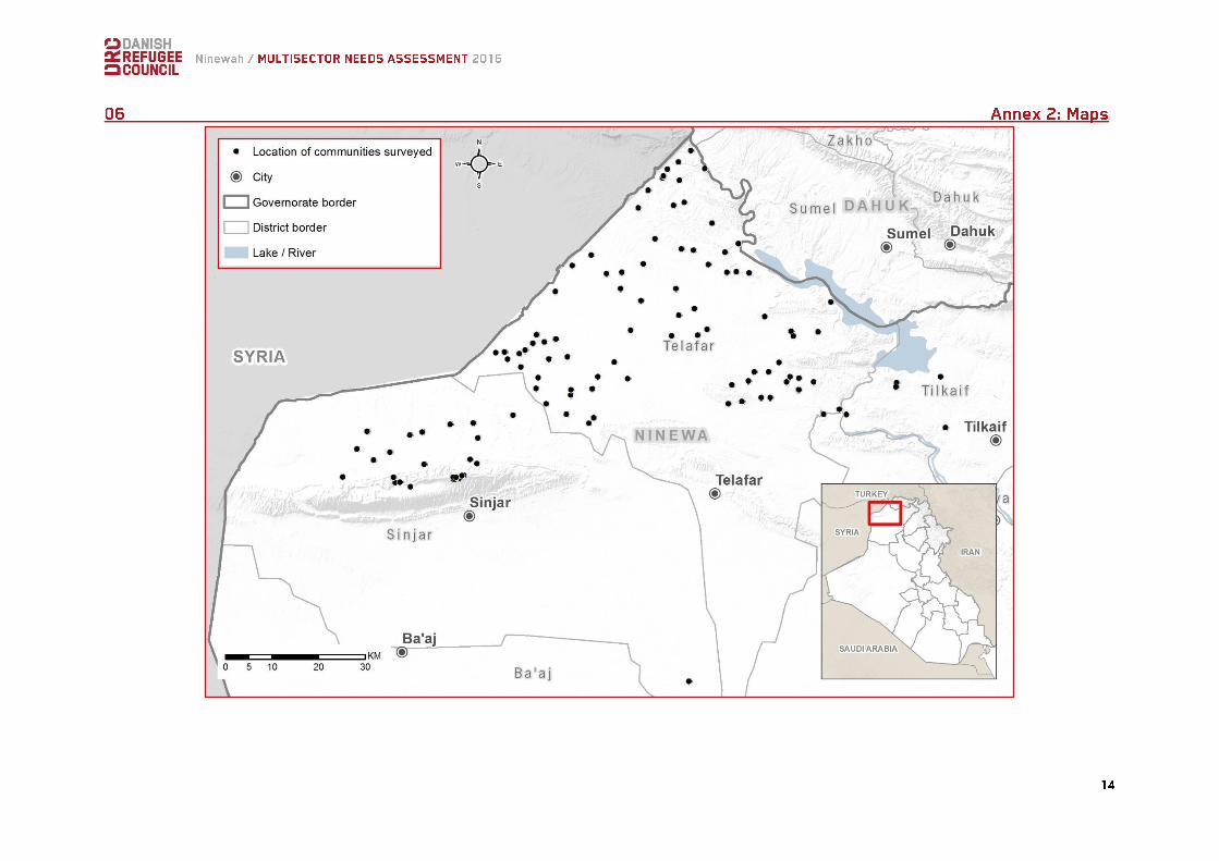
This study covers the parts of the Rabe’a, Wana, Sinuni, and Zummar sub-districts which were accessible to DRC. Each have distinct social, political and economic backgrounds. The Rabe’a sub-district, which sits on the border with Syria, is predominantly Arab, many of whom are from the Shammar tribe. Rabe’a city is arguably the largest urbanised location in Northern Ninewah, with irregular cross-border trade supporting a significant informal economy. Poor infrastructure, as well as chronic shortages in water and electricity,
1 Amnesty International, 2016, “Banished and Dispossessed Forced Displacement and Deliberate Destruction in Northern Iraq”
have severely affected the potential for productive economic activity. Wana’s principally agrarian economy has been heavily affected by significant displacement as well as damage resulting from the conflict. The economic future of sub-district remains uncertain, particularly whilst large sections of the population of the sub-district currently in Garmarwa IDP camp have been unable to return. As with elsewhere in the district, Zummar’s economy is based mainly on farming of wheat
as well as other crops, although some non-agricultural production activities are based in Zummar town, the largest peri-urban location in the sub-district. The area is majority Kurdish, but with a significant Arab minority.
Livestock and animal husbandry has traditionally played an important role in the economy of Sinuni. The sub-district has a substantial Yazidi population, and also sustained significant damage during conflict.
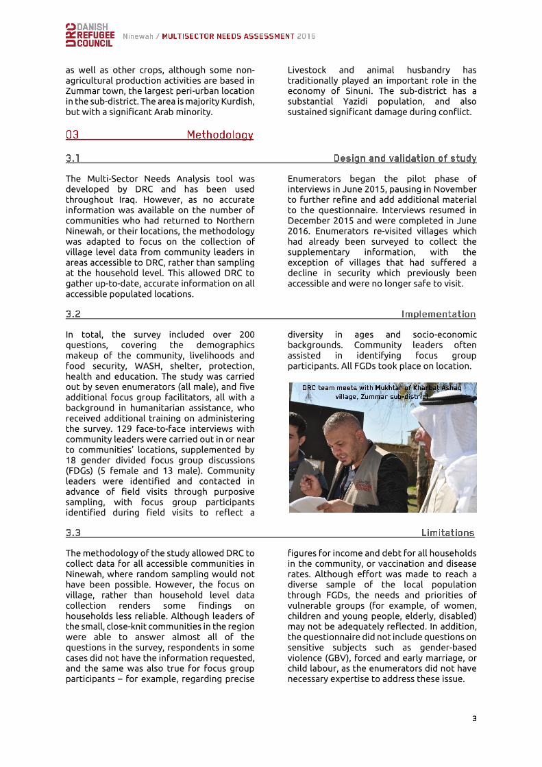
The Multi-Sector Needs Analysis tool was developed by DRC and has been used throughout Iraq. However, as no accurate information was available on the number of communities who had returned to Northern Ninewah, or their locations, the methodology was adapted to focus on the collection of village level data from community leaders in areas accessible to DRC, rather than sampling at the household level. This allowed DRC to gather up-to-date, accurate information on all accessible populated locations.
Enumerators began the pilot phase of interviews in June 2015, pausing in November to further refine and add additional material to the questionnaire. Interviews resumed in December 2015 and were completed in June 2016. Enumerators re-visited villages which had already been surveyed to collect the supplementary information, with the exception of villages that had suffered a decline in security which previously been accessible and were no longer safe to visit.
In total, the survey included over 200 questions, covering the demographics makeup of the community, livelihoods and food security, WASH, shelter, protection, health and education. The study was carried out by seven enumerators (all male), and five additional focus group facilitators, all with a background in humanitarian assistance, who received additional training on administering the survey. 129 face-to-face interviews with community leaders were carried out in or near to communities’ locations, supplemented by 18 gender divided focus group discussions (FDGs) (5 female and 13 male). Community leaders were identified and contacted in advance of field visits through purposive sampling, with focus group participants identified during field visits to reflect a
diversity in ages and socio-economic backgrounds. Community leaders often assisted in identifying focus group participants. All FGDs took place on location.
The methodology of the study allowed DRC to collect data for all accessible communities in Ninewah, where random sampling would not have been possible. However, the focus on village, rather than household level data collection renders some findings on households less reliable. Although leaders of the small, close-knit communities in the region were able to answer almost all of the questions in the survey, respondents in some cases did not have the information requested, and the same was also true for focus group participants – for example, regarding precise
figures for income and debt for all households in the community, or vaccination and disease rates. Although effort was made to reach a diverse sample of the local population through FGDs, the needs and priorities of vulnerable groups (for example, of women, children and young people, elderly, disabled) may not be adequately reflected. In addition, the questionnaire did not include questions on sensitive subjects such as gender-based violence (GBV), forced and early marriage, or child labour, as the enumerators did not have necessary expertise to address these issue.

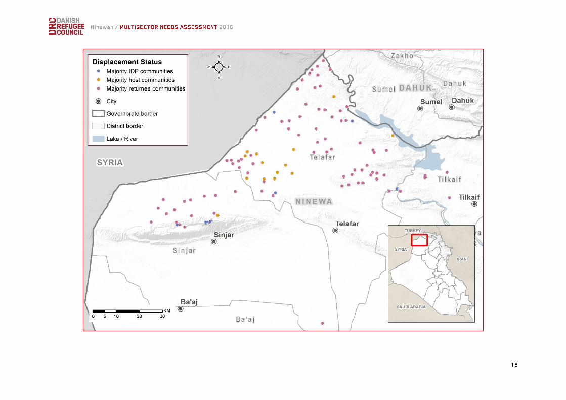
The survey covered almost 130 communities, approximately 150,000 individuals (53% women and 47% men, approximately 25,000 families2) in total. The study suggests that an extremely high number of households (27%) are headed by women, children, persons with disabilities or elderly persons. Approximately 11% of the population overall had some form of disability (mostly visual and hearing disabilities, as well as learning difficulties), and some 4% of the surveyed population were reported to suffer from chronic illnesses. 55% of the communities were Kurdish, 42% were Arabic, and 3% were mixed. Approximately 60% of the villages and towns in the four sub-districts were either uninhabited or inaccessible3. The most populated sub-districts were Rabe’a (41% of surveyed communities) and Zummar (31% of surveyed communities). Only five inhabited communities in Wana were accessible. Around 80% of the surveyed population are returnees, and around 13% still displaced4. Only a small number of communities have not been displaced. Access to land and/or
property following the re-taking of territory from IS was the most frequently given reason for return, suggesting more families will continue to return as further gains are made by Peshmerga (KRG) and Iraqi Security Forces. The majority of communities appear to be able to move freely in the region, although 23% reported some form of restrictions on movement, including the need to apply for permission to travel to Dohuk, the closest large city. 85% of the communities who reported some form of movement restrictions were Arab.
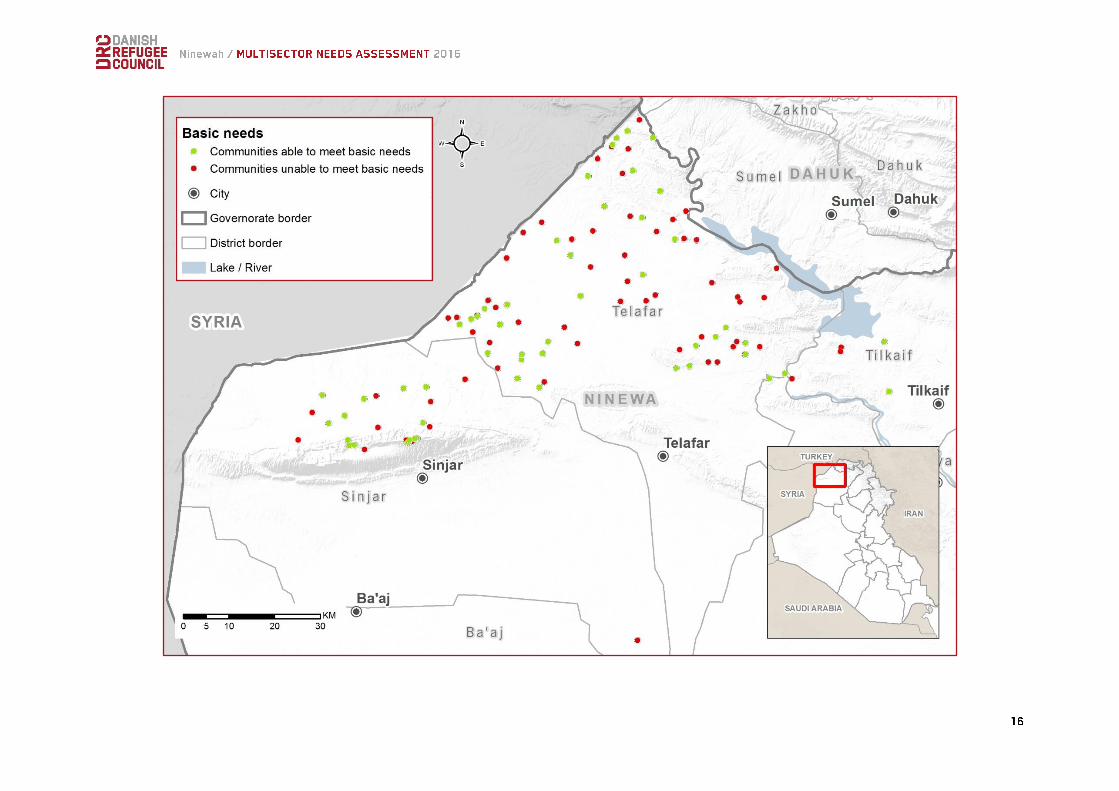
Findings show that many households, and communities, are extremely vulnerable. Over half reported that members of the community were unable to afford basic needs and many communities supporting themselves with savings and borrowed money rather than income. Both male and female focus groups were more likely to report that their communities were unable to meet basic needs than community leaders (55% of community leaders, as opposed to 60% of female focus groups and 62% of male focus groups). However, ethnicity does not appear to have a strong effect, suggesting communities who have been able to return face similar level of hardship. Communities in Zummar were most likely to report difficulties meeting basic needs than elsewhere, although needs were relatively high across all sub-districts surveyed.
2 Based on the standard planning assumption of an average family size of 6 persons per household
3 Based on existing geographic/population data 4 See Annex 2 map for further details
Rabe'a Sinuni Wana Zummar
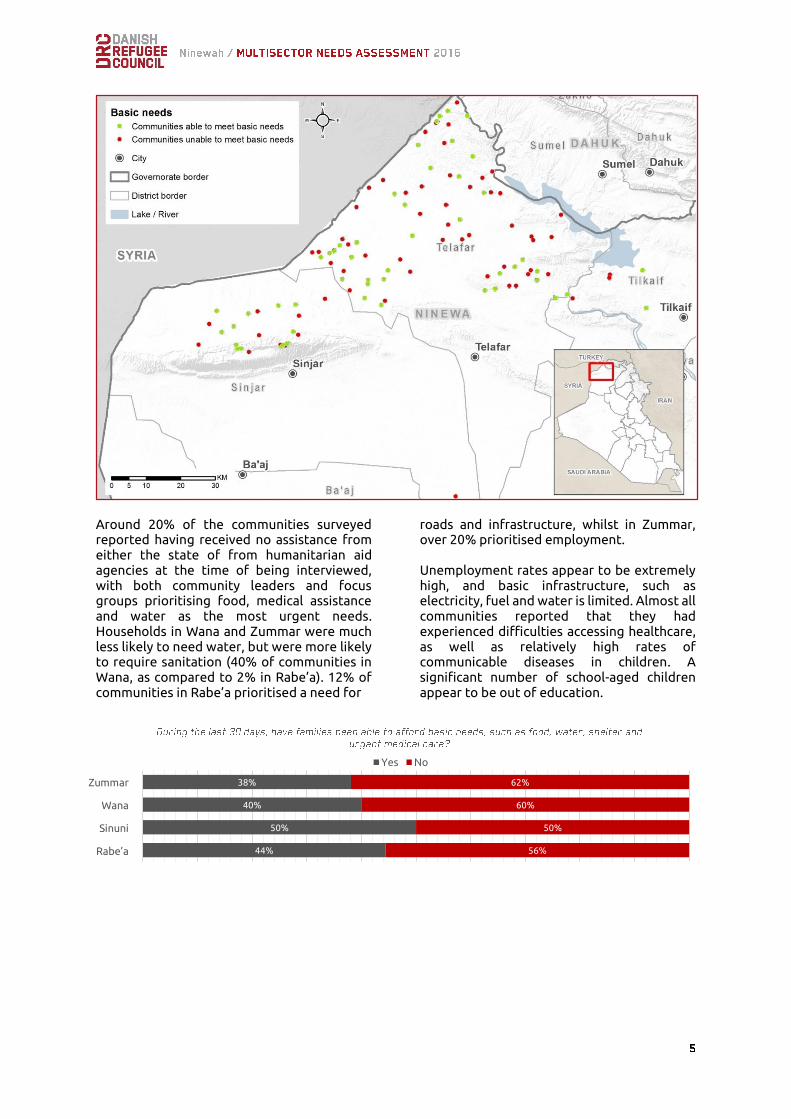
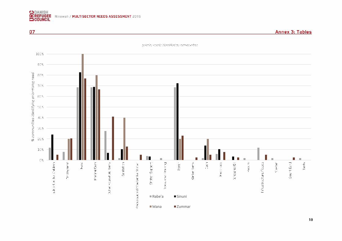
Around 20% of the communities surveyed reported having received no assistance from either the state of from humanitarian aid agencies at the time of being interviewed, with both community leaders and focus groups prioritising food, medical assistance and water as the most urgent needs. Households in Wana and Zummar were much less likely to need water, but were more likely to require sanitation (40% of communities in Wana, as compared to 2% in Rabe’a). 12% of communities in Rabe’a prioritised a need for
roads and infrastructure, whilst in Zummar, over 20% prioritised employment. Unemployment rates appear to be extremely high, and basic infrastructure, such as electricity, fuel and water is limited. Almost all communities reported that they had experienced difficulties accessing healthcare, as well as relatively high rates of communicable diseases in children. A significant number of school-aged children appear to be out of education.
44%
50%
40%
38%
56%
50%
60%
62%
Rabi'Ah
Sinuni
Wana
Zumar
Yes No
Zummar
Wana
Sinuni
Rabe’a
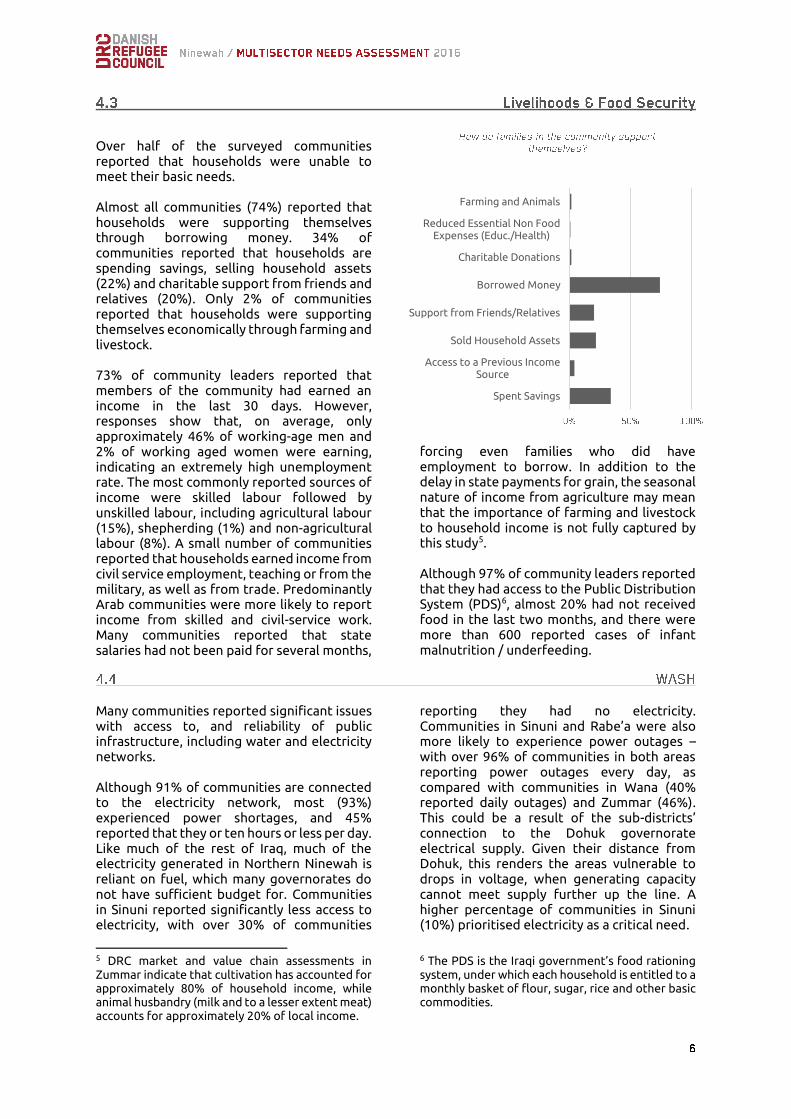
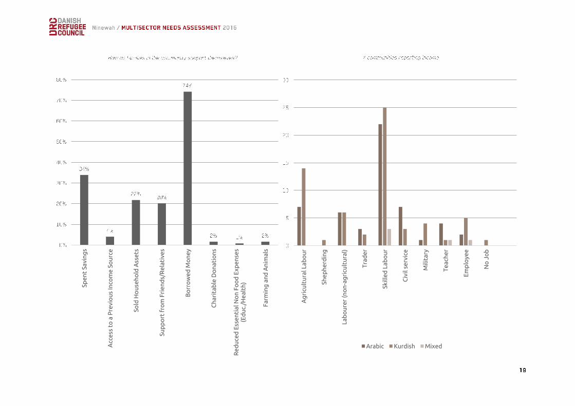
Over half of the surveyed communities reported that households were unable to meet their basic needs. Almost all communities (74%) reported that households were supporting themselves through borrowing money. 34% of communities reported that households are spending savings, selling household assets (22%) and charitable support from friends and relatives (20%). Only 2% of communities reported that households were supporting themselves economically through farming and livestock. 73% of community leaders reported that members of the community had earned an income in the last 30 days. However, responses show that, on average, only approximately 46% of working-age men and 2% of working aged women were earning, indicating an extremely high unemployment rate. The most commonly reported sources of income were skilled labour followed by unskilled labour, including agricultural labour (15%), shepherding (1%) and non-agricultural labour (8%). A small number of communities reported that households earned income from civil service employment, teaching or from the military, as well as from trade. Predominantly Arab communities were more likely to report income from skilled and civil-service work. Many communities reported that state salaries had not been paid for several months,
forcing even families who did have employment to borrow. In addition to the delay in state payments for grain, the seasonal nature of income from agriculture may mean that the importance of farming and livestock to household income is not fully captured by this study5. Although 97% of community leaders reported that they had access to the Public Distribution System (PDS)6, almost 20% had not received food in the last two months, and there were more than 600 reported cases of infant malnutrition / underfeeding.
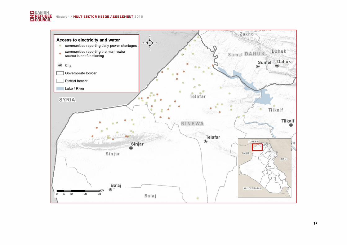
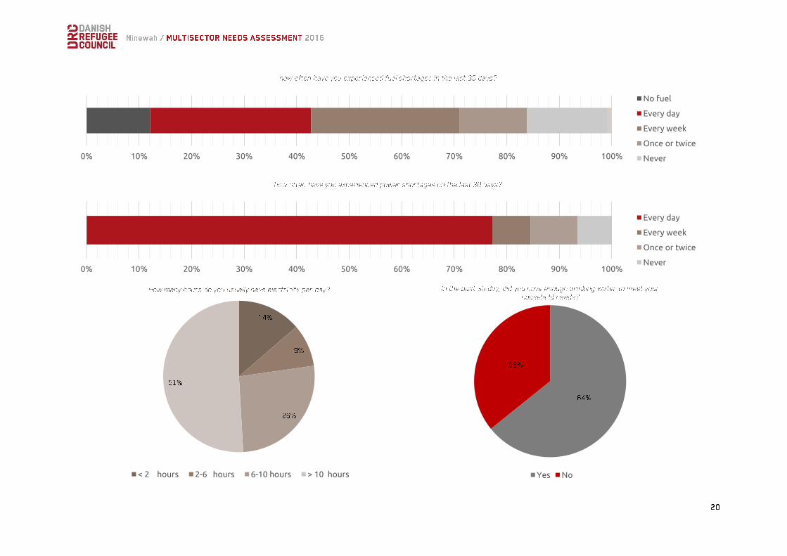
Many communities reported significant issues with access to, and reliability of public infrastructure, including water and electricity networks. Although 91% of communities are connected to the electricity network, most (93%) experienced power shortages, and 45% reported that they or ten hours or less per day. Like much of the rest of Iraq, much of the electricity generated in Northern Ninewah is reliant on fuel, which many governorates do not have sufficient budget for. Communities in Sinuni reported significantly less access to electricity, with over 30% of communities
5 DRC market and value chain assessments in Zummar indicate that cultivation has accounted for approximately 80% of household income, while animal husbandry (milk and to a lesser extent meat) accounts for approximately 20% of local income.
reporting they had no electricity. Communities in Sinuni and Rabe’a were also more likely to experience power outages – with over 96% of communities in both areas reporting power outages every day, as compared with communities in Wana (40% reported daily outages) and Zummar (46%). This could be a result of the sub-districts’ connection to the Dohuk governorate electrical supply. Given their distance from Dohuk, this renders the areas vulnerable to drops in voltage, when generating capacity cannot meet supply further up the line. A higher percentage of communities in Sinuni (10%) prioritised electricity as a critical need.
6 The PDS is the Iraqi government’s food rationing system, under which each household is entitled to a monthly basket of flour, sugar, rice and other basic commodities.
Spent Savings
Access to a Previous IncomeSource
Sold Household Assets
Support from Friends/Relatives
Borrowed Money
Charitable Donations
Reduced Essential Non FoodExpenses (Educ./Health)
Farming and Animals
Almost 85% of communities had experienced fuel shortages, of which 12% (15 communities) reported having no fuel at all. Access to fuel is a particular problem in winter, when it is required to run heating - 100% of communities reported being wholly or partially reliant on kerosene to heat their homes. This suggests that support for winterization and provision of fuel, vouchers or cash in particular, will be a key concern for the winter.
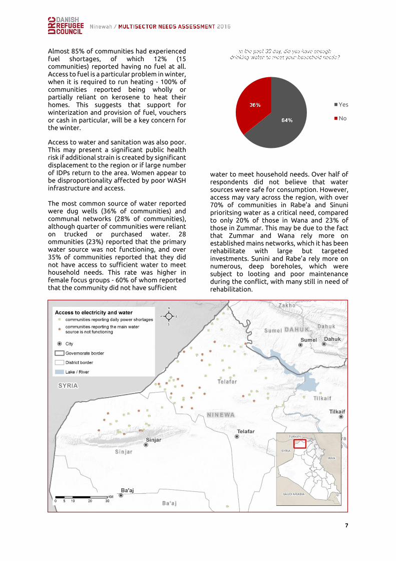
Access to water and sanitation was also poor. This may present a significant public health risk if additional strain is created by significant displacement to the region or if large number of IDPs return to the area. Women appear to be disproportionality affected by poor WASH infrastructure and access. The most common source of water reported were dug wells (36% of communities) and communal networks (28% of communities), although quarter of communities were reliant on trucked or purchased water. 28 ommunities (23%) reported that the primary water source was not functioning, and over 35% of communities reported that they did not have access to sufficient water to meet household needs. This rate was higher in female focus groups - 60% of whom reported that the community did not have sufficient
water to meet household needs. Over half of respondents did not believe that water sources were safe for consumption. However, access may vary across the region, with over 70% of communities in Rabe’a and Sinuni prioritsing water as a critical need, compared to only 20% of those in Wana and 23% of those in Zummar. This may be due to the fact that Zummar and Wana rely more on established mains networks, which it has been rehabilitate with large but targeted investments. Sunini and Rabe’a rely more on numerous, deep boreholes, which were subject to looting and poor maintenance during the conflict, with many still in need of rehabilitation.
Yes
No

Community leaders reported that some 55% of communities did not have access to basic latrines. However, 100% of the female focus groups7 reported that they did not have access to a latrine. Solid waste management infrastructure was similarly limited. Less than 10% of communities reported that waste was collected by the municipality, or that they had access to communal rubbish facilities, with the majority of respondents suggesting that waste was thrown in open space (50.4%) or burnt (39.5%). Lack of effective solid waste management and sanitation may be one of the contributing factors to the high reported rates of communicable disease in children under five, with 11% of this population reported as suffering from respiratory tract infections, skin infections, fever or diarrhoea. The total
lack of facilities for managing sewage is of concern, given that the expected emergency response from the Mosul operations will see a potentially significant increase in the population. DRC has been active in Northern Ninewah since January 2016, working to improve WASH infrastructure for vulnerable communities. This has included improvements to solid waste management capacity in Sinuni and Rabe’a, rehabilitation of water and electrical networks in the Zummar area, the installation of chlorination units in Rabe’a. This work is continuing throughout 2016-17, including through emergency preparedness activities in response to the anticipated military operations to re-take Mosul.
The study suggests a very large number of potentially vulnerable households in the region. Over 3,400 households, 14% of the total approximately 25,000 households covered by this survey, are reportedly female-headed, over 2,000 (8%) are headed by elderly persons, 797 (3%) are headed by people with disabilities, and 366 (1%) are reportedly headed by children. This may in part be a
7 Four of which were in the Sinuni sub-district, and one of which was in Rabe’a. 8 The Information Card is a summary document which contains the details of other personal
result of the targeted killings of male heads of households by IS. Over 1,300 individuals are reported to have a serious physical disability (44% of all reported disabilities), and over 650 individuals were reported to have learning difficulties. Just under 1,000 individuals were reported to have visual, hearing or speech impairments. Households in 42% of the surveyed communities are missing one or more civil document. The most common documents not held are ID cards, with community leaders also reporting that households did not have food ration cards, citizenship documents, passports and information documents8. Lack of documents can significantly affect access to assistance, travel, and land rights. Without civil documents like national IDs or food ration cards, households may not be able to register with the Ministry of Displacement and Migration (MoDM), which can prevent access to services and assistance households are entitled to. Lack of documentation can impede safe travel and access between governorates and at checkpoints, and valid identity documents are also required to register births or show proof of paternity, and to prove ownership of land. This issue is particularly sensitive in Ninewah for displaced communities in which abandoned properties have been occupied by IDPs or returnees. The majority of respondents (85% of community leaders) did not perceive there to
documents, such as the ID card and ration card, and can be used when applying for state services.

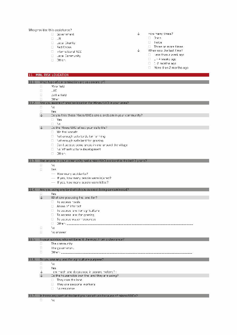
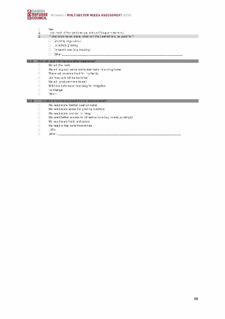
be any threats to their safety and security in their current locations. None of the male focus groups reported feeling unsafe, although one of the five female focus groups (the group in the Rabe’a area) did report perceived threats to their security in their current location9. Only 10% of communities (13 in total) were aware of the presence of Explosive Remnants of War (ERW) in their area, with 9 community leaders reporting that there had been a ERW related incident in the immediate area in the last 12 months. In all 13 locations with known ERW contamination, community leaders reported that it prevented access to agricultural land (6 respondents) made people feel unsafe (6 respondents) or prevented access to some parts of the village. Although no accurate figures on the extent of contamination exist, ongoing clearance
operations suggest a significant presence of ERW and Improvised Explosive Devices (IED) in the region. In May and June 2016 alone, more than 250 ERW and over 1,000 IEDs were disposed of in the Zummar and Sinuni sub-districts by humanitarian actors10. While in control of the areas, IS planted victim initiated IEDs to secure positions and as tactical barriers, leaving the rural areas, particularly Sinuni, as well as roads and urban locations, heavily contaminated. With the level of contamination, men and boys, particularly farmers, shepherds and herb collectors are particularly at-risk. Since April 2016 Danish Demining Group (DDG) has been working with relevant actors to raise awareness of the threat of ERW and IEDs in the sub-district of Zummar.
The majority of surveyed communities were rural settlements (47%). 30% of communities were identified as urban dwellers, and 22% peri-urban. The Zummar sub-district is the most urbanized district of the four sub-districts surveyed, with Rabe’a the most rural. Arab communities were significantly more likely to live in rural locations, whilst Kurdish communities were more likely to identify as urban or peri-urban.
Although this study did not include a technical shelter damage assessment component, 86% of respondents reported that they required some sort of shelter rehabilitation, with assistance to repair windows and roofs the most commonly stated need. However, few communities identified shelter support as a critical need (1%), suggesting that those with severely damaged homes have not returned to the region.
Only 38% of school-age children (aged 6-18), just over 21,000 children in the surveyed communities were reported to be attending
9 Only five female focus group discussions were held, which limits detailed comparison. In the community in question, the community leader did not report any perceived threats to safety and security, suggesting that the environment may be
school11. Attendance rates were higher for boys than girls across all age ranges, and dropped significantly for older children.
less safe for women. No further information as collected on the nature of threats perceived. 10 MAG monthly activities summary, June 2016 11 Based on UN population profiles, which suggest that 38% of the Iraqi population are school-aged children
boys girls
boys girls boys girls boy girls
6-11 12-15 16-18
Almost 11,000 children between the ages of 6-11 were reported to be attending school, dropping to under 7,000 for children aged 12-15, while only 4,000 children between the age of 16 and 18 were still in education. 85% of
respondents reported that households in the community were unable to afford school supplies, such as writing materials, books, bags and clothes, factors that may contribute to drop-out rates.
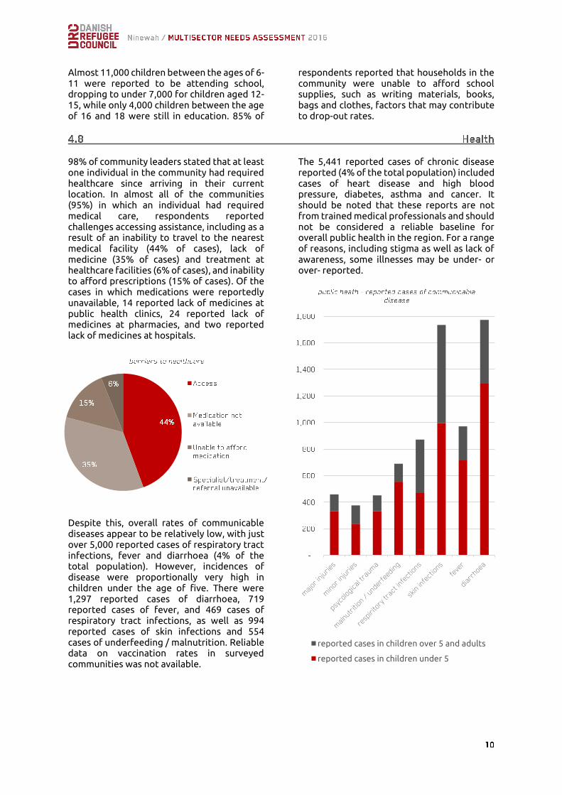
98% of community leaders stated that at least one individual in the community had required healthcare since arriving in their current location. In almost all of the communities (95%) in which an individual had required medical care, respondents reported challenges accessing assistance, including as a result of an inability to travel to the nearest medical facility (44% of cases), lack of medicine (35% of cases) and treatment at healthcare facilities (6% of cases), and inability to afford prescriptions (15% of cases). Of the cases in which medications were reportedly unavailable, 14 reported lack of medicines at public health clinics, 24 reported lack of medicines at pharmacies, and two reported lack of medicines at hospitals.
Despite this, overall rates of communicable diseases appear to be relatively low, with just over 5,000 reported cases of respiratory tract infections, fever and diarrhoea (4% of the total population). However, incidences of disease were proportionally very high in children under the age of five. There were 1,297 reported cases of diarrhoea, 719 reported cases of fever, and 469 cases of respiratory tract infections, as well as 994 reported cases of skin infections and 554 cases of underfeeding / malnutrition. Reliable data on vaccination rates in surveyed communities was not available.
The 5,441 reported cases of chronic disease reported (4% of the total population) included cases of heart disease and high blood pressure, diabetes, asthma and cancer. It should be noted that these reports are not from trained medical professionals and should not be considered a reliable baseline for overall public health in the region. For a range of reasons, including stigma as well as lack of awareness, some illnesses may be under- or over- reported.
reported cases in children over 5 and adults
reported cases in children under 5
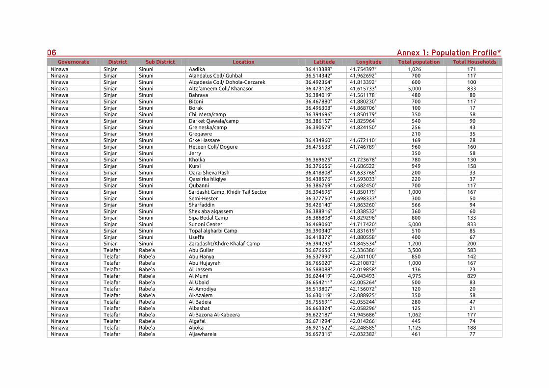
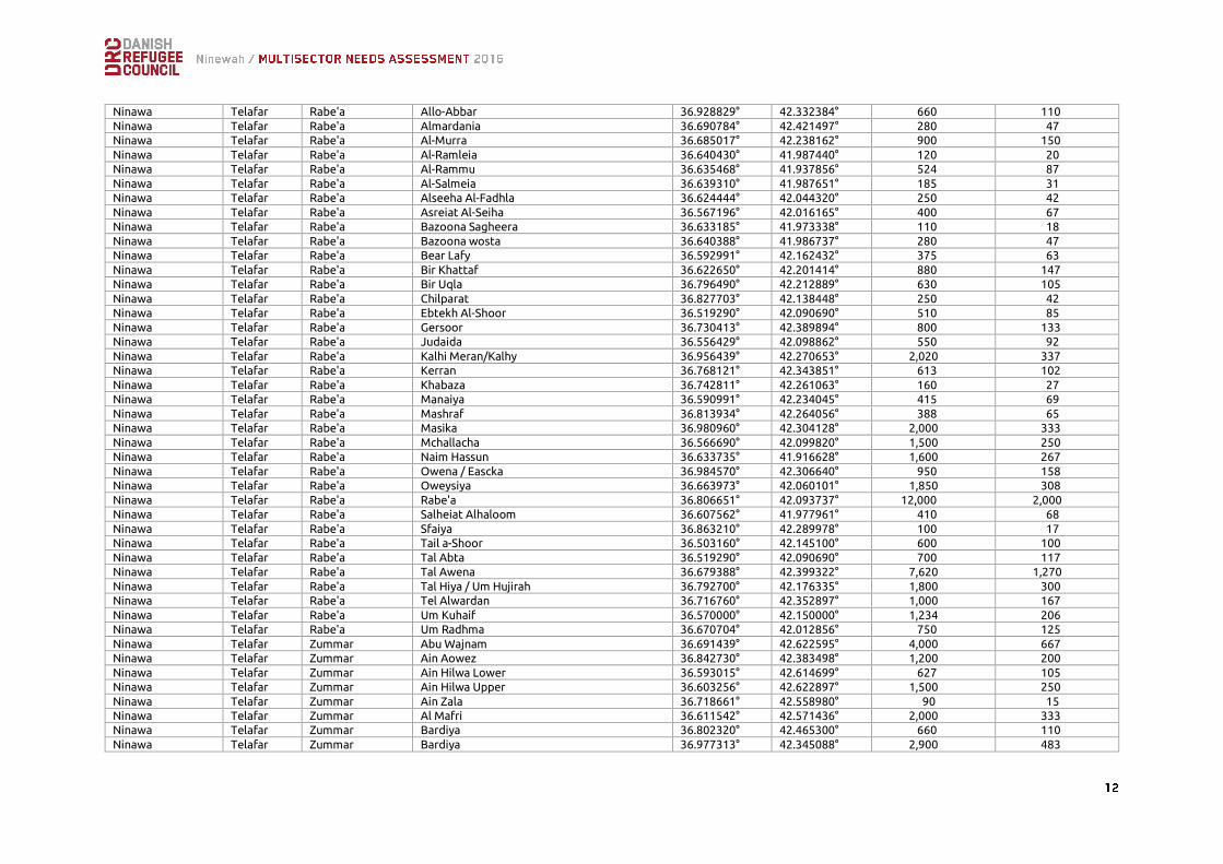
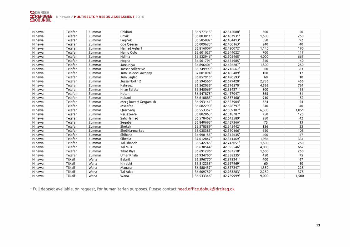
Governorate District Sub District Location Latitude Longitude Total population Total Households
Ninawa Sinjar Sinuni Aadika 36.413388° 41.754397° 1,026 171
Ninawa Sinjar Sinuni Alandalus Coll/ Guhbal 36.514342° 41.962692° 700 117
Ninawa Sinjar Sinuni Alqadesia Coll/ Dohola-Gerzarek 36.492364° 41.813392° 600 100
Ninawa Sinjar Sinuni Alta'ameem Coll/ Khanasor 36.473128° 41.615733° 5,000 833
Ninawa Sinjar Sinuni Bahrava 36.384019° 41.561178° 480 80
Ninawa Sinjar Sinuni Bitoni 36.467880° 41.880230° 700 117
Ninawa Sinjar Sinuni Borak 36.496308° 41.868706° 100 17
Ninawa Sinjar Sinuni Chil Mera/camp 36.394696° 41.850179° 350 58
Ninawa Sinjar Sinuni Darket Qawala/camp 36.386157° 41.825964° 540 90
Ninawa Sinjar Sinuni Gre neska/camp 36.390579° 41.824150° 256 43
Ninawa Sinjar Sinuni Gregawre 210 35
Ninawa Sinjar Sinuni Grke Hassare 36.434960° 41.672110° 169 28
Ninawa Sinjar Sinuni Heteen Coll/ Dogure 36.475533° 41.746789° 960 160
Ninawa Sinjar Sinuni Jerry 350 58
Ninawa Sinjar Sinuni Kholka 36.369625° 41.723678° 780 130
Ninawa Sinjar Sinuni Kursi 36.376656° 41.686522° 949 158
Ninawa Sinjar Sinuni Qaraj Sheva Rash 36.418808° 41.633768° 200 33
Ninawa Sinjar Sinuni Qassirka hliqiye 36.438576° 41.593033° 220 37
Ninawa Sinjar Sinuni Qubanni 36.386769° 41.682450° 700 117
Ninawa Sinjar Sinuni Sardasht Camp, Khidir Tail Sector 36.394696° 41.850179° 1,000 167
Ninawa Sinjar Sinuni Semi-Hester 36.377750° 41.698333° 300 50
Ninawa Sinjar Sinuni Sharfaddin 36.426140° 41.863260° 566 94
Ninawa Sinjar Sinuni Shex aba alqassem 36.388916° 41.838532° 360 60
Ninawa Sinjar Sinuni Sipa Bedal Camp 36.386808° 41.829298° 800 133
Ninawa Sinjar Sinuni Sunoni Center 36.469060° 41.717420° 5,000 833
Ninawa Sinjar Sinuni Topal algharbi Camp 36.390340° 41.831619° 510 85
Ninawa Sinjar Sinuni Useffa 36.418372° 41.880558° 400 67
Ninawa Sinjar Sinuni Zaradasht/Khdre Khalaf Camp 36.394295° 41.845534° 1,200 200
Ninawa Telafar Rabe'a Abu Gullar 36.676656° 42.336386° 3,500 583
Ninawa Telafar Rabe'a Abu Hanya 36.537990° 42.041100° 850 142
Ninawa Telafar Rabe'a Abu Hujayrah 36.765020° 42.210872° 1,000 167
Ninawa Telafar Rabe'a Al Jassem 36.588088° 42.019858° 136 23
Ninawa Telafar Rabe'a Al Mumi 36.624419° 42.043493° 4,975 829
Ninawa Telafar Rabe'a Al Ubaid 36.654211° 42.005264° 500 83
Ninawa Telafar Rabe'a Al-Amodiya 36.513807° 42.156072° 120 20
Ninawa Telafar Rabe'a Al-Azaiem 36.630119° 42.088925° 350 58
Ninawa Telafar Rabe'a Al-Badeia 36.755691° 42.055244° 280 47
Ninawa Telafar Rabe'a Albashat 36.663324° 42.058296° 125 21
Ninawa Telafar Rabe'a Al-Bazona Al-Kabeera 36.622187° 41.945686° 1,062 177
Ninawa Telafar Rabe'a Algafal 36.671294° 42.014266° 445 74
Ninawa Telafar Rabe'a Alioka 36.921522° 42.248585° 1,125 188
Ninawa Telafar Rabe'a Aljawhareia 36.657316° 42.032382° 461 77
Ninawa Telafar Rabe'a Allo-Abbar 36.928829° 42.332384° 660 110
Ninawa Telafar Rabe'a Almardania 36.690784° 42.421497° 280 47
Ninawa Telafar Rabe'a Al-Murra 36.685017° 42.238162° 900 150
Ninawa Telafar Rabe'a Al-Ramleia 36.640430° 41.987440° 120 20
Ninawa Telafar Rabe'a Al-Rammu 36.635468° 41.937856° 524 87
Ninawa Telafar Rabe'a Al-Salmeia 36.639310° 41.987651° 185 31
Ninawa Telafar Rabe'a Alseeha Al-Fadhla 36.624444° 42.044320° 250 42
Ninawa Telafar Rabe'a Asreiat Al-Seiha 36.567196° 42.016165° 400 67
Ninawa Telafar Rabe'a Bazoona Sagheera 36.633185° 41.973338° 110 18
Ninawa Telafar Rabe'a Bazoona wosta 36.640388° 41.986737° 280 47
Ninawa Telafar Rabe'a Bear Lafy 36.592991° 42.162432° 375 63
Ninawa Telafar Rabe'a Bir Khattaf 36.622650° 42.201414° 880 147
Ninawa Telafar Rabe'a Bir Uqla 36.796490° 42.212889° 630 105
Ninawa Telafar Rabe'a Chilparat 36.827703° 42.138448° 250 42
Ninawa Telafar Rabe'a Ebtekh Al-Shoor 36.519290° 42.090690° 510 85
Ninawa Telafar Rabe'a Gersoor 36.730413° 42.389894° 800 133
Ninawa Telafar Rabe'a Judaida 36.556429° 42.098862° 550 92
Ninawa Telafar Rabe'a Kalhi Meran/Kalhy 36.956439° 42.270653° 2,020 337
Ninawa Telafar Rabe'a Kerran 36.768121° 42.343851° 613 102
Ninawa Telafar Rabe'a Khabaza 36.742811° 42.261063° 160 27
Ninawa Telafar Rabe'a Manaiya 36.590991° 42.234045° 415 69
Ninawa Telafar Rabe'a Mashraf 36.813934° 42.264056° 388 65
Ninawa Telafar Rabe'a Masika 36.980960° 42.304128° 2,000 333
Ninawa Telafar Rabe'a Mchallacha 36.566690° 42.099820° 1,500 250
Ninawa Telafar Rabe'a Naim Hassun 36.633735° 41.916628° 1,600 267
Ninawa Telafar Rabe'a Owena / Eascka 36.984570° 42.306640° 950 158
Ninawa Telafar Rabe'a Oweysiya 36.663973° 42.060101° 1,850 308
Ninawa Telafar Rabe'a Rabe'a 36.806651° 42.093737° 12,000 2,000
Ninawa Telafar Rabe'a Salheiat Alhaloom 36.607562° 41.977961° 410 68
Ninawa Telafar Rabe'a Sfaiya 36.863210° 42.289978° 100 17
Ninawa Telafar Rabe'a Tail a-Shoor 36.503160° 42.145100° 600 100
Ninawa Telafar Rabe'a Tal Abta 36.519290° 42.090690° 700 117
Ninawa Telafar Rabe'a Tal Awena 36.679388° 42.399322° 7,620 1,270
Ninawa Telafar Rabe'a Tal Hiya / Um Hujirah 36.792700° 42.176335° 1,800 300
Ninawa Telafar Rabe'a Tel Alwardan 36.716760° 42.352897° 1,000 167
Ninawa Telafar Rabe'a Um Kuhaif 36.570000° 42.150000° 1,234 206
Ninawa Telafar Rabe'a Um Radhma 36.670704° 42.012856° 750 125
Ninawa Telafar Zummar Abu Wajnam 36.691439° 42.622595° 4,000 667
Ninawa Telafar Zummar Ain Aowez 36.842730° 42.383498° 1,200 200
Ninawa Telafar Zummar Ain Hilwa Lower 36.593015° 42.614699° 627 105
Ninawa Telafar Zummar Ain Hilwa Upper 36.603256° 42.622897° 1,500 250
Ninawa Telafar Zummar Ain Zala 36.718661° 42.558980° 90 15
Ninawa Telafar Zummar Al Mafri 36.611542° 42.571436° 2,000 333
Ninawa Telafar Zummar Bardiya 36.802320° 42.465300° 660 110
Ninawa Telafar Zummar Bardiya 36.977313° 42.345088° 2,900 483
Ninawa Telafar Zummar Chkhori 36.977313° 42.345088° 300 50
Ninawa Telafar Zummar Chvik 36.803811° 42.487931° 1,500 250
Ninawa Telafar Zummar Faqirok 36.585087° 42.484413° 550 92
Ninawa Telafar Zummar Gos Qeeran 36.009673° 42.400163° 240 40
Ninawa Telafar Zummar Hamad Agha 1 36.816009° 42.420072° 1,140 190
Ninawa Telafar Zummar Hamo Golo 36.601027° 42.644022° 700 117
Ninawa Telafar Zummar Hdima 36.532946° 42.705465° 4,000 667
Ninawa Telafar Zummar Hogna 36.561791° 42.554985° 840 140
Ninawa Telafar Zummar Jarzuniya 36.896401° 42.426287° 1,500 250
Ninawa Telafar Zummar Jassar collective 36.749999° 42.716667° 500 83
Ninawa Telafar Zummar Jum Baieev Fawqany 37.001094° 42.405489° 100 17
Ninawa Telafar Zummar Jum Laglag 36.857915° 42.490593° 60 10
Ninawa Telafar Zummar Jussa North 2 36.594566° 42.679420° 2,736 456
Ninawa Telafar Zummar Kahreez 36.562036° 42.576570° 4,565 761
Ninawa Telafar Zummar Khan Safata 36.845069° 42.354271° 800 133
Ninawa Telafar Zummar Kotan 36.547873° 42.477047° 365 61
Ninawa Telafar Zummar Kubani 36.610883° 42.537160° 910 152
Ninawa Telafar Zummar Merg lower/ Gergamish 36.593141° 42.523904° 324 54
Ninawa Telafar Zummar Mseafna 36.682290° 42.628797° 240 40
Ninawa Telafar Zummar Qasr Sarij 36.553357° 42.509187° 6,303 1,051
Ninawa Telafar Zummar Rai jazeera 36.802063° 42.518787° 750 125
Ninawa Telafar Zummar Sahl Hamad 36.578462° 42.643589° 250 42
Ninawa Telafar Zummar Sequba 36.840693° 42.459366° 75 13
Ninawa Telafar Zummar Shekak 36.578589° 42.645442° 136 23
Ninawa Telafar Zummar Shelikia-market 37.035385° 42.370166° 650 108
Ninawa Telafar Zummar Shibana 36.998155° 42.315635° 400 67
Ninawa Telafar Zummar Siheala 37.012847° 42.341469° 1,986 331
Ninawa Telafar Zummar Tal Dhahab 36.542745° 42.743051° 1,500 250
Ninawa Telafar Zummar Tal Mus 36.630544° 42.595546° 4,000 667
Ninawa Telafar Zummar Tibat Riya 36.691296° 42.687518° 1,500 250
Ninawa Telafar Zummar Umar Khala 36.934760° 42.358335° 450 75
Ninawa Tilkaif Wana Babnit 36.596770° 42.878241° 400 67
Ninawa Tilkaif Wana Khrabki 36.512233° 42.997969° 60 10
Ninawa Tilkaif Wana Manara 36.588437° 42.877247° 1,350 225
Ninawa Tilkaif Wana Tal Adas 36.609759° 42.983283° 2,250 375
Ninawa Tilkaif Wana Wana 36.533346° 42.759999° 9,000 1,500
* Full dataset available, on request, for humanitarian purposes. Please contact [email protected]
Rabe'a Sinuni
Wana Zummar
Sp
en
t S
av
ing
s
Acc
ess
to
a P
rev
iou
s In
com
e S
ou
rce
So
ld H
ou
seh
old
Ass
ets
Su
pp
ort
fro
m F
rie
nd
s/R
ela
tiv
es
Bo
rro
we
d M
on
ey
Ch
ari
tab
le D
on
ati
on
s
Re
du
ced
Ess
en
tia
l N
on
Fo
od
Ex
pe
nse
s(E
du
c./H
ea
lth
)
Fa
rmin
g a
nd
An
ima
ls
Ag
ricu
ltu
ral
La
bo
ur
Sh
ep
he
rdin
g
La
bo
ure
r (n
on
-ag
ricu
ltu
ral)
Tra
de
r
Sk
ille
d L
ab
ou
r
Civ
il s
erv
ice
Mil
ita
ry
Te
ach
er
Em
plo
ye
e
No
Jo
b
Arabic Kurdish Mixed
0% 10% 20% 30% 40% 50% 60% 70% 80% 90% 100%
Every day
Every week
Once or twice
Never
0% 10% 20% 30% 40% 50% 60% 70% 80% 90% 100%
No fuel
Every day
Every week
Once or twice
Never
Yes No< 2 hours 2-6 hours 6-10 hours > 10 hours
↓
↓
↓
↓
↓
↓
↓
↓
↓
↓
↓
↓
↓
↓
↓
↓
↓
↓
↓
↓
↓
↓
↓
↓
↓
↓
↓
↓
↓
↓
↓
↓
↓
↓
↓
↓
↓
↓
↓
↓
↓
↓
↓
↓
↓
↓
↓
↓
↓
↓
↓
↓ ↓
↓
↓