Draft Environmental Assessment Sarasota … Environmental Assessment . Sarasota Emergency Operations...
27
Draft Environmental Assessment Sarasota Emergency Operations Center Sarasota County Emergency Management, Sarasota County, Florida Grant No.’s 20009-EO-MX-0033 and 2010-EO-MX-0027 August 4, 2011 U.S. Department of Homeland Security FEMA Region X 130 228 th Street SW Bothell, WA 98021-9796
-
Upload
hoangtuyen -
Category
Documents
-
view
214 -
download
1
Transcript of Draft Environmental Assessment Sarasota … Environmental Assessment . Sarasota Emergency Operations...

Draft Environmental Assessment Sarasota Emergency Operations Center Sarasota County Emergency Management, Sarasota County, Florida Grant No.’s 20009-EO-MX-0033 and 2010-EO-MX-0027 August 4, 2011
U.S. Department of Homeland Security FEMA Region X
130 228th Street SW Bothell, WA 98021-9796

Sarasota County
Emergency Operations Center National Environmental Policy Act
Environmental Assessment
FEMA Grant No.’s 2009-EO-MX-0033 (4) and 2010 –EO-MX-0027
August 4, 2011
Prepared For:
Sarasota County Planning Services 1660 Ringling Blvd., 1st Floor
Sarasota, FL 34236
Submitted To:
U.S. Department of Homeland Security Emergency Operations Center Grant Program
Washington DC, 20528 https://grants.gov
Prepared By:
Cardno ENTRIX 22 Sarasota Center Boulevard
Sarasota, FL 34240 T 941 378-0660 F 941 378-0780
Victoria A. Fera Staff Scientist
Kerri A. MacNutt Project Scientist

Table of Contents 1.0 Introduction ................................................................................................................................... 1
2.0 NEPA Process Overview .............................................................................................................. 1
3.0 Project Overview and Background ............................................................................................... 1
4.0 Project Purpose and Need ............................................................................................................. 2
5.0 Alternatives Considered ................................................................................................................ 2
5.1 No Action Alterantive 1 ................................................................................................... 2
5.2 Construct New Emergency Operations Center – Proposed Alternative 2 ....................... 3
5.3 Alternatives Considered and Dismissed .......................................................................... 3
6.0 Affected Environment and Potential Impacts ............................................................................... 3
6.1 Geology and Soils………………………………………………………………………..6
6.2 Air Quality ....................................................................................................................... 7
6.3 Coastal Resources ............................................................................................................ 8
6.4 Compatible Land Use ...................................................................................................... 9
6.5 Biological Resources ....................................................................................................... 9
6.6 Water Resources ............................................................................................................ 11
6.6.1 Wetlands and Waters of the US ............................................................................ 11
6.6.2 Floodplain ............................................................................................................. 12
6.6.3 Water Quality………………………………………………………………….….12
6.6.4 Wild and Scenic Rivers………………………………………………..………….13
6.7 Hazardous Materials, Pollution Prevention, and Solid Waste ....................................... 13
6.8 Historical, Archaeological and Tribal Resources .......................................................... 14
6.9 Climate Change…………………………………………………………………………15
6.10 Natural Resources and Energy Supply .......................................................................... 16
6.11 Noise .............................................................................................................................. 16
6.12 Light Emissions and Visual Impacts .............................................................................. 17
6.13 Socioeconomic Impacts and Environmental Justice ...................................................... 17
6.14 Cumulative Impacts……………………………………………………………………..18
7.0 Special Purpose (Federal, State, Local Government) Law/Permitting Considerations .............. 18

7.1 Sarasota County Demolition / Building Permit ............................................................. 18
7.2 Sarasota County Site and Development/Construction Approval ................................... 18
7.3 State of Florida Environmental Resource Permit .......................................................... 18
8.0 Public Involvement ..................................................................................................................... 19
9.0 Conclusion…………………………………………………………………………………….…19
10. References………………………………………………………………………………….……19
Exhibits Exhibit 1 Location Map (Existing and Proposed Facility) Exhibit 2 Land Use Map (Proposed Facility) Exhibit 3 Aerial Map (Existing Facility) Exhibit 4 Master Site Plan Exhibit 5 Soils Map Exhibit 6 Ardaman & Associates, Inc. Phase I Environmental Site Assessment Exhibit 7 Dunkelberger Engineering and Testing, Inc. Phase II Environmental Site Assessment Exhibit 8 State Clearing House Letter/Email Dated 7 February 2011 Exhibit 9 Zoning Map (Proposed Facility) Exhibit 10 WilsonMiller Stantec Environmental Due Diligence Report – Executive Summary Exhibit 11 SWFWMD Petition No. 42035664.000 Exhibit 12 Grand Trees Location Map (Proposed Facility) Exhibit 13 Eagle Nest Location Map (Proposed Facility) Exhibit 14 Federal Emergency Management Agency (FEMA) Flood Zones Map (Proposed
Facility) Exhibit 15 Cardno ENTRIX State Historic Preservation Office Request Exhibit 16 Florida Department of State Division of Historical Resources Letter
Dated November 1, 2010 Exhibit 17 Seminole Tribal Consultation Request Letters Exhibit 18 Public Notice
Tables Table 1 Alternative Analysis

List of Acronyms, Abbreviations and Symbols
APE Area of Potential Effect BGEPA Bald and Golden Eagle Protection Act BMPs Best Management Practices CEQ Council on Environmental Quality CFR Code of Federal Regulations CWA Clean Water Act CZMA Coastal Zone Management Act DNR Florida Department of Natural Resources DHR Florida Department of State Division of Historical Resources DHS U.S. Department of Homeland Security DNL Day/Night Noise Level EA Environmental Assessment EIS Environmental Impact Statement EO Executive Order EOC Emergency Operations Center EPA Environmental Protection Agency ERP Environmental Resource Permit ESA Endangered Species Act FAC Florida Administrative Code FCMP Florida Coastal Management Program FCREPA Florida Committee on Rare and Endangered Plants and Animals FDEP Florida Department of Environmental Protection FEMA Federal Emergency Management Agency FIRMS Flooding Insurance Rate Maps FNAI Florida Natural Areas Inventory FONSI Finding of No Significant Impact FPPA Farmland Protection Policy Act FS Florida Statutes FFWCC Florida Fish and Wildlife Conservation Commission FWS U.S. Fish and Wildlife Service GIS Geospatial Information System GWCTL Groundwater Cleanup Target Level GPS Global Positioning System GU Government Use HAPS Hazardous Air Pollutants HW Hazardous Wastes JCP Joint Coastal Permit ILW Industrial, Light and Warehousing LEED Leadership in Energy and Environmental Design MBTA Migratory Bird Treaty Act MDL Mean Detection Limits NAAQ National Ambient Air Quality

NCA Noise Control Act NESHAPS National Emission Standards for Hazardous Air Pollutants NEPA National Environmental Policy Act NHPA National Historic Protection Act NMFS National Marine Fisheries Service NPDES National Pollutant Discharge Elimination System NRCS National Resources Conservation Service NRHP National Register of Historic Places NWI National Wetlands Inventory OPI Office, Professional and Institutional PID Photoionization Detector SCTL Soil Cleanup Target Level SHPO State Historic Preservation Officer (of the Florida Department of State) SWFWMD Southwest Florida Water Management District SSL Sovereign Submerged Lands S/T/R Section, Township, Range SWANNC Solid Waste Authority of North Cook County USACE U.S. Army Corps of Engineers USC U.S. Census USCG U.S. Coast Guard USGBC U.S. Green Building Coalition

Page 1 of 27
1.0 INTRODUCTION Sarasota County has applied to the U.S. Department of Homeland Security (DHS) Federal Emergency Management Agency (FEMA) for funding through FY2009 and 2010 Emergency Operations Center Grant Program to assist with construction of a new Emergency Operations Center (EOC) that meets current hurricane standards. Existing emergency operations for the County are based out of the Administration Building on Ringling Boulevard in downtown Sarasota, Florida (Exhibit 1). The new EOC will be located on existing County property where a Government Building Complex already exists. The property is located east of Cattleman Road to the west and south of Porter Way abutting the north side of the property, in Section 25, Township 36 South, Range 18 East, Sarasota County, Florida (Exhibit 1). More specifically, the parcel is surrounded by commercial and governmental development to the north, south, and west, and interstate to the east as shown on the Land Use Map (Exhibit 2). Sarasota County Government proposes to construct a new facility to house the County’s Emergency Operations Center, Consolidated 911 Call Center, Fire Department Administration Offices and Enterprise Information Technology Data Center. The new facility will be designed to withstand Category 5 hurricane winds and is to remain operational during all storm events and other hazards. The Sarasota County EOC will serve as the central command and control facility responsible for carrying out the principles of emergency preparedness and management during emergency situations.
2.0 NEPA PROCESS OVERVIEW
This Environmental Assessment (EA) has been prepared in accordance with the National Environmental Policy Act (NEPA) of 1969, the President’s Council on Environmental Quality (CEQ) regulations to implement NEPA (40 Code of Federal Regulations [CFR] Parts 1500-1508), and FEMA’s regulations implementing NEPA (44 CFR Part 10). FEMA is required to consider potential environmental impacts before funding or approving actions and projects. The purpose of this EA is to analyze the potential environmental impacts of the Sarasota County Emergency Operations Center Project. FEMA will use the findings in this EA to determine whether to prepare an Environmental Impact Statement (EIS) or a Finding of No Significant Impact (FONSI).
3.0 PROJECT OVERVIEW AND BACKGROUND Sarasota County’s Emergency Operations Center, Consolidated 911 Center and Enterprise Information Technology Data Center is currently based out of the County’s existing Administration Building located in downtown Sarasota at 1660 Ringling Boulevard (Exhibit 3). However, the structural integrity of the administration building was in question relative to hurricane standards, and a study was recently done to evaluate the structure for this purpose. The study involved the testing of the envelope/cladding and structural frame to withstand a Category 5 Wind Event. The analysis of the structural components was performed in accordance with the 2004 Florida Building Code w/ the 2005 and 2006 Amendments. Utilizing a variety of methods which included the original construction drawings, renovation drawings, structural inspections, and wind tunnel testing (Cermak, Peterka, Peterson Inc., Fort Collins, Colorado), it was determined that without an extensive retrofit, the current location could not withstand a Category 4 or above Wind Event. Sarasota County Government evaluated the estimated cost to retrofit the existing building and determined that based on the age of the building (1972), construction cost, service interruption, and a ground floor elevation of fifteen feet, which places the structure in a Category 4 evacuation zone, a retrofit of the existing building did not meet Sarasota County Government’s cost-benefit-analysis.
Page 2 of 27
Currently, when threatened by a Category 3 or higher storm, Sarasota County Government maintains a policy to relocate the EOC/911 Center to the back-up site. The back-up site maintains the same functionality as the primary location, but at a reduced capability. At the back-up site, which is an elementary school, the EOC staff operates at a 50 percent reduction in the number of data and voice connections and must operate in four separate classrooms, which further diminishes direct communications opportunities. Currently, the 911/EOC has the capability to answer twelve telephone calls simultaneously, while at the back-up center the capability is reduced to six telephone calls simultaneously. Additionally, because the back-up EOC/911 Center is located within a building of an elementary school, it adds to the time sensitivity as to how long operations may be sustained from the back-up location. The current project will address the deficiencies by relocating the EOC operations to a new facility located at the existing Sarasota County Government Building Complex on Cattlemen Road which is outside of any storm surge evacuation zone. EOC construction is to occur primarily on the southeast parcel located at 6052 porter Way (Parcel ID No. 0049-01-0004); however, overflow parking may also occur on the adjacent parcel to the west located at 1301 Cattleman Road (Parcel ID No. 0049-01-0005). As shown on the Land Use map (Exhibit 2), the majority of the Cattleman Road site was developed to accommodate government buildings which currently house a number of offices for various County disciplines. Mictron, an aerospace, medical and automotive parts manufacturer, also operating on this site under a lease agreement with the County. The proposed action includes the construction of a new facility capable of withstanding Category 5 Wind Events in which case existing structures may have to be demolished to accommodate the EOC. The possibility of expanding and/or retrofitting the existing government buildings on Cattleman Road was explored. However, the existing buildings do not meet the Category 5 standards and the cost of retrofitting these buildings exceed costs for the construction of a new facility from the ground up. Therefore, one of the buildings that is currently under lease by Mictron (on Parcel 0049-01-0004) will be targeted for demolition and rebuild. No new activity is proposed on the other adjacent parcels with the exception of overflow parking. The project will efficiently enhance the EOC/911 Center capabilities by maintaining the same current level of service to meet the needs of our community as our existing facility and a viable facility for continuous operations in the case of a Category 3 or higher storm. This project will enable Sarasota County Government to reduce future cost by; eliminating the need to maintain additional infrastructure at a back-up site, occupying an energy efficient structure, and constructing a new facility with the flexibility to meet our citizen’s growing demands.
4.0 PROJECT PURPOSE AND NEED
The purpose of the EOC grant program is to enhance State and local emergency management capabilities through provision of grant funding. The purpose of this project is to improve the central command and control facilities responsible for carrying out the principles of emergency preparedness and management during emergency situations. The need for the action is outlined in Section 3.0 Project Overview and Background.
5.0 ALTERNATIVES CONSIDERED
5.1 No Action Alternative 1
Under the No Action Alternative, FEMA would not partially fund the proposed project for the construction of the EOC, and emergency operations would continue to function out of the existing

Page 3 of 27
Administration Building (on Ringling Blvd.) and relocate to a back-up site during a Category 3 or higher storm.
5.2 Proposed Alternative 2 - Construct New Facility to Accommodate EOC on Alternative
County Property (Existing Government Complex) Sarasota County is proposing to demolish an existing building at the County’s existing Government Complex (on Cattleman Road) and construct an new facility to house the County’s Emergency Operations Center, Consolidated 911 Call Center, Fire Department Administration Offices and Enterprise Information Technology Data Center that will be designed to withstand Category 5 hurricane winds and is to remain operational during all storm events and other hazards. A master site plan is attached that shows the layout of existing government buildings on the property (Exhibit 4). One of the existing buildings on Parcel C (designated as building 6) will be demolished and reconstructed to Category 5 hurricane standards to accommodate the EOC which will consist of a two-story building totaling approximately 30,000 square feet. Infrastructure to support the EOC will consist of 80 additional parking spaces (totaling approximately 28,00 square feet), a stormwater retention pond and an up to 150’ free standing communication tower (20 x 20 feet base) with equipment; all of which be constructed on Parcel C immediately adjacent to the EOC building. The existing history center building located north of the proposed EOC will remain onsite and no activity will occur on the adjacent parcels (A and B); with the exception of overflow parking where necessary. As stated above, the center is being constructed to withstand Category 5 hurricane winds; which will be accomplished with either pre-cast concrete or tilt wall, concrete slab, and a heavy metal shed roof. The project has been designed to meet minimum certification requirements for US Green Building Coalition (USGBC) Leadership in Energy and Environmental Design (LEED) standards to implement green/sustainable design practices. These standards will include: sustainable site design through the use of an existing developed site; daylight harvesting to minimize the need for artificial lighting; access to public transport; indoor air quality design consideration; the use of sustainable construction material and resources; efficient water use and low flow plumbing fixtures; and energy efficient electrical fixtures and lighting. 5.3 Alternatives Considered and Dismissed
As discussed in Section 3 Background, the County did evaluate retrofits to its existing EOC and given the scale of needed retrofits, determined that alternative was not cost effective and did not meet the above stated project purpose. Constructing a new facility elsewhere in the County was also considered, but permitting and construction costs were greater. The proposed site on Cattleman Road is already developed and owned by Sarasota County which allows for sustainable use of the site, and is also surrounded by similar governmental facilities. Consequently, no other alternatives were carried forward in the EA.
6.0 AFFECTED ENVIRONMENT AND POTENTIAL IMPACTS
For each resource category, the impact analysis follows the same general approach. When possible, quantitative information is provided to establish impacts. Qualitatively, these impacts will be measured based on the criteria below. • None/Negligible: The resource area would not be affected, or changes would be either non-detectable
or if detected, would have effects that would be slight and local. Impacts would be well below regulatory standards, as applicable.
Page 4 of 27
• Minor: Changes to the resource would be measurable, although the changes would be small and localized. Impacts would be within or below regulatory standards, as applicable. Mitigation measures would reduce any potential adverse effects.
• Moderate: Changes to the resource would be measurable and have both localized and regional scale impacts. Impacts would be within or below regulatory standards, but historical conditions are being altered on a short-term basis. Mitigation measures would be necessary and the measures would reduce any potential adverse effects.
• Major: Changes would be readily measurable and would have substantial consequences on a local and regional level. Impacts would exceed regulatory standards. Mitigation measures to offset the adverse effects would be required to reduce impacts, though long-term changes to the resource would be expected.
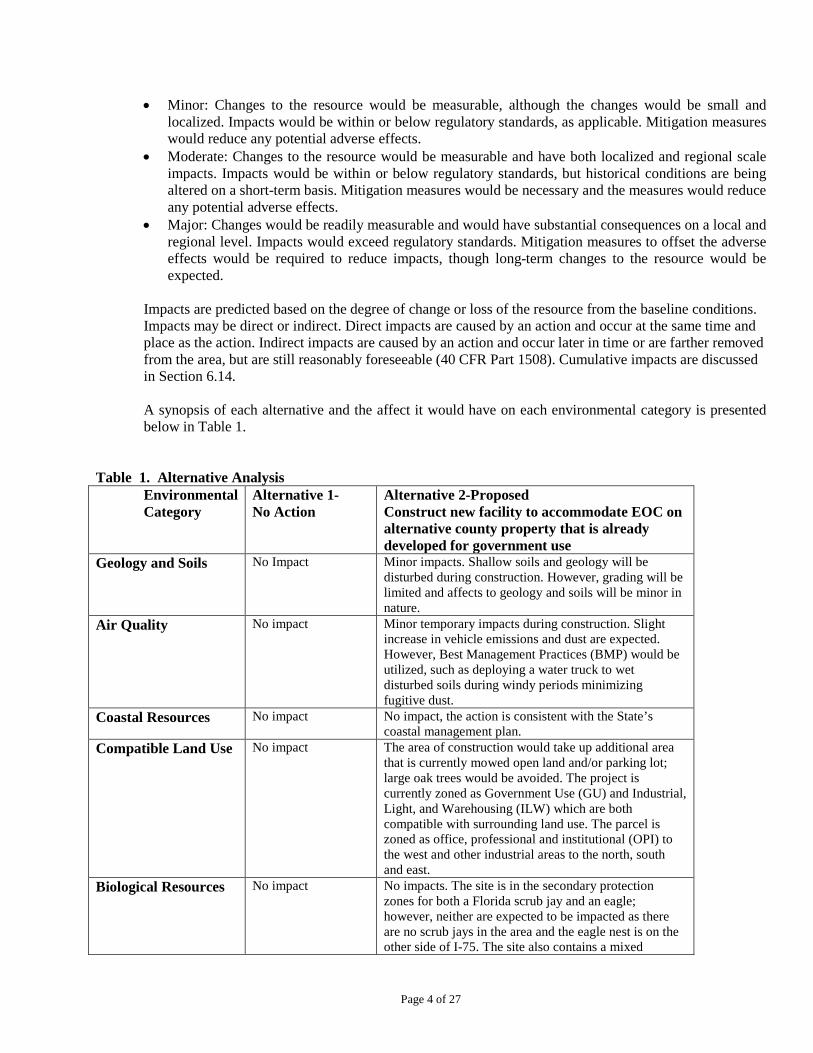
Impacts are predicted based on the degree of change or loss of the resource from the baseline conditions. Impacts may be direct or indirect. Direct impacts are caused by an action and occur at the same time and place as the action. Indirect impacts are caused by an action and occur later in time or are farther removed from the area, but are still reasonably foreseeable (40 CFR Part 1508). Cumulative impacts are discussed in Section 6.14. A synopsis of each alternative and the affect it would have on each environmental category is presented below in Table 1.
Table 1. Alternative Analysis Environmental Category
Alternative 1- No Action
Alternative 2-Proposed Construct new facility to accommodate EOC on alternative county property that is already developed for government use
Geology and Soils No Impact Minor impacts. Shallow soils and geology will be disturbed during construction. However, grading will be limited and affects to geology and soils will be minor in nature.
Air Quality No impact Minor temporary impacts during construction. Slight increase in vehicle emissions and dust are expected. However, Best Management Practices (BMP) would be utilized, such as deploying a water truck to wet disturbed soils during windy periods minimizing fugitive dust.
Coastal Resources No impact No impact, the action is consistent with the State’s coastal management plan.
Compatible Land Use No impact The area of construction would take up additional area that is currently mowed open land and/or parking lot; large oak trees would be avoided. The project is currently zoned as Government Use (GU) and Industrial, Light, and Warehousing (ILW) which are both compatible with surrounding land use. The parcel is zoned as office, professional and institutional (OPI) to the west and other industrial areas to the north, south and east.
Biological Resources No impact No impacts. The site is in the secondary protection zones for both a Florida scrub jay and an eagle; however, neither are expected to be impacted as there are no scrub jays in the area and the eagle nest is on the other side of I-75. The site also contains a mixed

Page 5 of 27
hardwood wetland; this is not expected to be impacted because it is south of the area of construction. Additionally, the grand trees onsite will be buffered and avoided during construction.
Wetlands No impact No impact, as the construction will occur outside of the wetland boundary and best management practices will be utilized to ensure additional protection from run-off during construction.
Floodplains No impact No impact. The project is not located in the 100 or 500-year floodplain.
Water Quality No impact Minor impacts during construction, the proposed facility will meet state water quality standards.
Wild and Scenic Rivers
No impact No impact, there are no nearby rivers.
Hazardous Materials, Pollution Prevention, and Solid Waste
No impact No impact. All potentially hazardous concerns previously identified onsite have been investigated and remediated as necessary.
Historic and Archaeological Resources
No impact No impact, no archaeological or historical resources identified onsite, nor are impacts to tribal resources expected.
Climate Change Minor. Currently, no green/sustainable design practices are being used which allows for more greenhouse gas emissions as a result of low-efficiency energy uses. Scattered emergency operations facilities also have greater carbon footprint.
Negligible positive impacts. Construction of the new facility will result in temporary releases of greenhouse gases associated with fuel burning equipment. However, the new facility will allow for consolidated emergency operations as opposed to the scattered facilities which have a larger carbon footprint. The new facility will also utilize green/sustainable design to minimize greenhouse gas emissions as opposed to the existing facility which was constructed well before sustainable design practices were being used resulting in low-efficiency energy uses.
Natural Resources and Energy Supply
Currently, no green/sustainable design practices are being utilized.
Positive impact. The proposed EOC will maximize utilization of green/sustainable design practices, including LEEDS where practicable.
Noise No impact Minor impacts. Construction will occur during normal daylight hours 7:00 a.m. to 5:00 p.m. and is not expected to exceed unacceptable noise levels.
Light Emissions and Visual Impacts
No impact Positive impact. The newly constructed building will increase aesthetic quality relative to some of the industrial facilities nearby. Additionally, current land use is consistent with surrounding land use.
Socioeconomic Impacts and Environmental Justice
No impact No impact. There are no minority or low income populations adjacent to the project area.
Cumulative Impacts No impact No cumulative impacts are expected to the environment; the parcels already are developed and being used for government use, and is surrounded by comparable land uses. The new building will also accommodate the same number of people as the existing facility although it will provide additional shelter for

Page 6 of 27
Category 3 or greater storm events to relieve some of the load from the nearby elementary school.
6.1 GEOLOGY AND SOILS
According to Open File Report 10 Geology of Sarasota County, Florida (1985), the project site is located in the Gulf Coastal Lowlands physiographic province (Campbell, 1985). This large north-south trending, low lying coastal area extends north to Hillsborough and Pinellas County and south to Charlotte County (at a minimum) and is bounded by the Desoto Plain zone to the east.
The Geologic Map of the State of Florida indicates that the site is underlain by a thin veneer of Holocene, Pleistocene and Pliocene series undifferentiated quartz sands, shell and clay. Beneath this surficial deposit of unconsolidated sediment lies interbedded sands, clays and carbonates comprising the Hawthorn Group. In this portion of the County, the Hawthorn Group contains the Peace River Formation from sea level to approximately 30 feet below sea level and the Arcadia Formation to a depth of approximately 450 feet below sea level. The Suwannee Limestone, Ocala Limestone and Avon Park Formation lithostratigraphic units occur successively deeper beneath the Arcadia Formation. These three units comprise the Floridan Aquifer system. The Floridan Aquifer System is confined in this portion of the County and wells penetrating is aquifer exhibit artesian flow. The interbedded sands, clays, limestone and dolomite of the Hawthorn Group comprise the Intermediate Aquifer System, which is also confined and under artesian pressure. Most potable wells in this portion of the County are located within the Intermediate Aquifer System. This portion of Florida is not known as being active with sinkhole development. Over 200 feet of interbedded sand, shell and clay overlie the carbonate rocks, which limits the development of karst features such as sinkholes. Very few sinkholes occur in Sarasota County with most being in the south part, such as Warm Mineral Springs and Little Salt Spring. The site is composed of three soil types, according to the Natural Resource Conservation Service’s (NRCS) Soils Survey for Sarasota County, Florida, Delray fine sand, depressional, Eaugallie and Myakka fine sands, and Holopaw fine sand, depressional (Exhibit 5). Delray fine sand, depressional is a nearly level, very poorly drained soil; under natural conditions water is ponded for six to nine months or the water table is typically within 12 inches of the surface; it is considered a hydric soil. Eaugallie and Myakka fine sands are nearly level, poorly drained soils; under natural conditions the water table is at a depth of 6 to 18 inches for 1 to 3 months and within a depth of more than 40 inches during the dry season; it is considered an upland soil. Holopaw fine sand, depressional is a nearly level very poorly drained soil that is ponded for 6 to 9 months and has a water table within 12 inches for the remaining months; it is considered a hydric soil. The Farmland Protection Policy Act (FPPA) regulates federal actions with the potential to convert farmland to non-agricultural uses. The FPPA assures that, to the extent possible, federal programs are administered to be compatible with state, local units of government, and private programs and policies to protect farmland. For the purpose of FPPA, farmland includes prime farmland, unique farmland, and land of statewide or local importance. Farmland subject to FPPA requirements does not have to be currently used for cropland. It can be forest land, pastureland, cropland, or other land, but not water or urban built-up land (http://www.nrcs.usda.gov/programs/fppa/).
Page 7 of 27
Alternative 1- No Action Alternative
No impact would occur since there would be no site development or construction.
Alternative 2- Proposed Alternative: Construct New Facility to Accommodate EOC on Alternative County Property Already Developed for Government Use (Existing Government Complex)
The proposed action will have minor impacts on shallow surficial geology and soils during site grading and construction. The site is relatively flat so grading will be limited and effects to geology and soils will be minor and temporary in nature. Given the lack of sinkhole activity near the project site and the relatively stable sand and shell deposits underlying the surface there are no hazards anticipated related to construction of structures. Further, erosion and sedimentation control Best Management Practices (BMP’s) will be implemented in accordance with state and federal requirements to prevent construction-related impacts to onsite and offsite soils and water quality. No impacts will occur to farmlands as the site is immediately surrounded by governmental and industrial uses.
6.2 AIR QUALITY
The Clean Air Act, which was last amended in 1990, requires EPA to set National Ambient Air Quality (NAAQ) Standards in accordance with 40 CFR part 50 for pollutants considered harmful to public health and the environment. The Clean Air Act established two types of NAAQ standards. Primary standards set limits to protect public health, including the health of "sensitive" populations such as asthmatics, children, and the elderly. Secondary standards set limits to protect public welfare, including protection against decreased visibility, damage to animals, crops, vegetation, and buildings (http://www.epa.gov/air/criteria.html). According to Sarasota County’s Air Quality Index (http://www.scgov.net/aqi/aqi.aspx), current conditions are good with the major pollutant being particulate, which is below the NAAQ standard. National Emission Standards for Hazardous Air Pollutants (NESHAPS) are stationary source standards for hazardous air pollutants. Hazardous air pollutants (HAPs) are those pollutants that are known or suspected to cause cancer or other serious health effects, such as reproductive effects or birth defects, or adverse environmental effects. Seven hazardous air pollutants are regulated; asbestos, beryllium, mercury, vinyl chloride, benzene, arsenic, and radon/radionuclides (http://www.epa.gov/oecaerth/monitoring/programs/caa/neshaps.html). A Phase I ESA that was conducted on Parcel 0049-01-0004 by Dunkelberger Engineering and Testing, Inc. in April 2006, which included an asbestos and lead assessment. The assessment revealed no evidence of recognized environmental conditions in connection with the property. The asbestos survey conducted by RET Associates confirmed asbestos in the underlining of a sink, in panel and countertop materials within fume hood enclosures and in joint compound used in interior drywall. These materials were reportedly located in the History Center (east building on Parcel C) and were removed during the renovations for the History Center. No lead paint was found in the buildings, but was confirmed in the yellow parking lot paint dividing the parking spaces. An asbestos survey was also conducted by OHC Environmental Engineering in September 2000 for Parcel 0049-01-0005 west of the EOC parcel and revealed some asbestos-containing materials. All materials containing asbestos were reported to be in good condition and therefore potential for release in an undisturbed condition is minimal. Alternative 1- No Action Alternative

Page 8 of 27
No impact would occur since there would be no site development or construction.
Alternative 2- Proposed Alternative: Construct New Facility to Accommodate EOC on Alternative County Property Already Developed for Government Use (Existing Government Complex) There would be minor, localized, and temporary affects to air quality during construction. Increased vehicle emissions and dust are expected as a result of demolition and construction activities; however, Best Management Practices (BMP) would be utilized during construction to mitigate any temporary air quality impacts, such as silt fences or deploying a water truck to control fugitive dust. Proper maintenance will also be conducted for any vehicles or fuel burning equipment, and running times for any such equipment will also be minimized to reduce emissions. The increased emissions would effectively cease upon completion of construction and no long term air quality degradation is anticipated. Asbestos findings on the EOC parcel were limited to the History Center building which was reportedly addressed during the renovations of the History Center. Furthermore, demolition onsite is limited to the Mictron building where no asbestos materials were found. Although asbestos was documented in the adjacent government buildings on the parcel to the west, no activities are occurring in these buildings. This parcel is only being used for overflow parking as necessary. Based on the asbestos surveys, no contamination has been found on the EOC parcel or surrounding parcels, nor does there appear to be any source of hazardous air pollutants on the site. Prior to demolition, any potentially hazardous materials or fixtures that exist in the Mictron building will be removed from the building in accordance with the FDEP’s Recommended Management Practices for the Removal of Hazardous Materials from Buildings Prior to Demolition (December 1999).Therefore no HAP emissions are expected as a result of the demolition or construction activities. 6.3 COASTAL RESOURCES
The Coastal Zone Management Act (CZMA) requires federal agencies to determine if their actions are consistent with the State’s coastal zone management plan. Sarasota County is within the designated coastal zone. The Florida Department of Environmental Protection (FDEP) implements section 161.055, of the Florida Statutes, initiating concurrent processing of applications for coastal construction permits, environmental resource permits, wetland resource (dredge and fill) permits, and sovereign submerged lands authorizations. These permits have been consolidated into a joint coastal permit (JCP). A JCP is required if; 1) the project is located on Florida’s natural sandy beaches facing the Atlantic Ocean, the Gulf of Mexico, the Straits of Florida or associated inlets, 2) activities extend seaward of the mean high water line, activities extend into sovereign submerged lands; and/or 3) if activities are likely to affect the distribution of sand along the beach (http://www.dep.state.fl.us/beaches/programs/envpermt.htm).
Alternative 1- No Action Alternative
No impact would occur since there would be no site development or construction.
Alternative 2- Proposed Alternative: Construct New Facility to Accommodate EOC on Alternative County Property Already Developed for Government Use (Existing Government Complex)
No impacts are expected, as there are not any coastal resources in the vicinity of the project site. Additionally, Florida State Clearinghouse staff has reviewed the Draft EA. The State has no objections to the allocation of federal funds for the referenced project and concluded, the funding award is consistent with the Florida Coastal Management Program (FCMP) (Exhibit 8).

Page 9 of 27
6.4 COMPATIBLE LAND USE
Currently, the existing County Government Complex on Cattleman Road (proposed EOC site) is surrounded by governmental, industrial, commercial and residential uses as shown on Exhibit 9. The property itself contains other government buildings and supporting infrastructure including parking lots and stormwater facilities. The north portion of the site also contains a building that is being leased by a light manufacturing company, and as such is still zoned for industrial purposes (ILW). However, the EOC is a permitted use under the ILW zoning category. In addition to these uses, the site is also characterized by mowed bahia grass (Paspalum notatum) and some large live oak (Quercus virginiana) scattered throughout the property (see Section 6.5 below). Also present on the property south of the existing buildings is a 1.9 acre forested wetland surrounded by mesic hammock (pine-mesic oak) and upland hardwood forest (Exhibit 2). More details on the native habitat onsite are addressed under Section 6.5 below. Alternative 1- No Action Alternative
No impact.
Alternative 2- Proposed Alternative: Construct New Facility to Accommodate EOC on Alternative County Property Already Developed for Government Use (Existing Government Complex) Although the exact footprint of the EOC has not yet been determined, it will likely be sited in the footprint of the existing light manufacturing building in which case demolition will be required to accommodate construction of the EOC facility. The area of construction would take up additional area that is currently mowed open land and/or parking lot; large oak trees would be avoided. The project is currently zoned as Government Use (GU) and Industrial, Light, and Warehousing (ILW) which are both compatible with surrounding land use.
6.5 BIOLOGICAL RESOURCES
Native or naturalized vegetation, wildlife and the habitats in which they occur are collectively referred to as biological resources, including Threatened and Endangered Species. An environmental due diligence was previously conducted by WilsonMiller Stantec of the subject property; the report is included as Exhibit 10 and contains more detailed descriptions of the vegetative communities. The majority of the site has been utilized for governmental purposes. The Endangered Species Act (ESA) was established to conserve, protect, and restore Threatened and Endangered species and their habitats. Section 7 of the ESA (50 CFR 402) requires Federal agencies to ensure their actions do not jeopardize the continued existence of listed species and do not result in adverse modification to designated critical habitat. As previously discussed, the site does contain a 1.9 acre forested wetland (characterized as mixed hardwood wetland) on the southern portion of the property. The boundaries of the wetland were delineated in accordance with Chapter 62-340 F.A.C. and verified by the Southwest Florida Water Management District (SWFWMD) per Petition No. 42035664.000 (Exhibit 11). The wetland canopy is dominated by laurel oak (Quercus laurifolia); the sub-canopy consists primarily of cabbage palm (Sabal palmetto) and scattered buttonbush (Cephalanthus occidentalis); groundcover consists primarily of Virginia chain fern, (Woodwardia virginica), maidencane (Panicum hemitomon), and smartweed (Polygonum spp.). Upland habitats were mapped in accordance with Florida Land Use and Cover Forms Classification System (FLUCFCS) and include mesic hammock (pine-mesic oak) and upland hardwood forests as

Page 10 of 27
shown on the Land Use Map (Exhibits 2 & 10). The mesic hammock areas are patchy forested areas consisting primarily of live oak and slash pine (Pinus elliottii). Furthermore, mesic hammock habitat is protected under the County’s Land Development Regulations and will be preserved consistent with their protection ordinances which allows no more than 25% of the habitat to be impacted. The upland hardwood forests have a closed canopy of oak with and an open sub-canopy of cabbage palm. Sarasota County Staff evaluated trees pursuant to Sarasota County’s Tree Ordinance [2007-091, Section 54.586(c)]. Several Grand trees were located and are reflected on the attached Exhibit 12. These Grand trees are also subject to protection by Sarasota County’s Tree Ordinance. Cardno ENTRIX conducted a thorough review of existing databases and literature for listed species potentially present within the study site. Sources used included the Sarasota County Scrub-jay database website, the Florida Fish and Wildlife Conservation Commission (FFWCC) online databases for wading birds and bald eagle nesting sites, U.S. Fish and Wildlife Service (FWS) species lists, Florida Natural Areas Inventory (FNAI), Florida Committee on Rare and Endangered Plants and Animals (FCREPA) texts, and a variety of other sources. In addition to a preliminary listed species survey conducted by WilsonMiller Stantec, in which none were observed; Cardno ENTRIX ecologists were also vigilant for the presence of listed wildlife species that may potentially occupy the available habitats on and immediately adjacent to the site. These included the gopher tortoise (Gopherus polyphemus), eastern indigo snake (Drymarchon corais) (federal threatened), gopher frog (Rana capito aesopus), Sherman’s fox squirrel (Sciurus niger shermani), Florida scrub-jay (Aphelocoma coerulescens) (federal threatened), and listed wading birds, such as the wood stork (Mycteria americana) (federal endangered), little blue heron (Egretta caerulea), snowy egret (Egretta thula), white ibis (Eudocimus albus), and the tricolored heron (Egretta tricolor). No evidence of listed species was documented on-site during the site visit. There is a low to moderate probability that wading birds may infrequently use portions of the surface water management system for foraging when conditions are conducive. However, we suspect that use is infrequent due to limited hydrology and lack of available prey. There is no nesting habitat for wading birds or Florida sandhill cranes either on-site or adjacent to the parcel. However; this site lies within the secondary use zone of the Florida scrub jay. Upland wildlife was not observed and is unlikely to occupy the project site. There was no evidence of gopher tortoise burrows and the site does not provide habitat required by Sherman’s fox squirrel, Florida scrub-jay or gopher frog. It is unlikely that the site would be used by the eastern indigo snake, but we recommend any future improvements to the site comply with the FWS’ Standard Protection Measures for the Eastern Indigo Snake (revised 11 August 1998). Standard protection measures should include education of clearing and construction crews regarding identification of eastern indigo snakes and measures to be taken if snakes are discovered during land clearing. Although bald eagles are no longer considered a State or federally listed species, they are still protected under the Migratory Bird Treaty Act (MBTA) and Bald and Golden Eagle Protection Act. Both Acts provides Federal protections for migratory birds including Bald Eagles, The MBTA includes a “no take” provision. Cardno ENTRIX staff conducted a bald eagle nest search of the surrounding area to confirm whether or not eagles are nesting on or within a minimum of 660 feet of the project site boundary. According to the FFWCC Eagle Nest Database, the project falls within the secondary protection zone of an eagle nest (Exhibit 13). However, the database indicates that the nest was last seen active in 2008 and no nest was observed during the last survey conducted in 2010. Also, the project area is generally within the Atlantic Flyway http://www.flyways.us/flyways/info, thus it’s possible migratory birds use the site during migration periods. The FWS provides design and lighting guidelines for communication towers that exceed 200’ feet in height.

Page 11 of 27
Alternative 1- No Action Alternative
No impact would occur since there would be no site development or construction. Alternative 2- Proposed Alternative: Construct New Facility to Accommodate EOC on Alternative County Property Already Developed for Government Use (Existing Government Complex)
Although a wetland is present, the area of proposed construction will occur well outside the 30 foot wetland buffer. Therefore, no wetland impacts are expected. Furthermore, mesic hammock will be maintained consistent with Sarasota County’s protection ordinances outlined under their Land Development Regulations. Several grand oaks were located onsite. During construction buffers will be maintained; therefore, the grand trees will not be impacted. No impacts to scrub jays is expected as the secondary use zone for scrub jays is a 1,300 to1,500 foot radius outside the primary zone which is solely based on soils. An inventory of potential sites was conducted in 2000 and this site, identified as Protection Area IP-08 was found to contain no scrub jays or suitable habitat, as it is entirely developed. No impact to the eagle nest is expected; the nest (if still in existence) is separated from the site by Interstate 75 (a six-lane high speed highway) and the construction activities are unlikely to be visible from the nest. The potential for impacts to migratory birds is minimal since the communication tower will not exceed 150’ and the area surrounding the site provides limited habitat suitability for migratory birds. As such, the proposed construction activities are not expected to result in impacts to the aforementioned protected species.
6.6 WATER RESOURCES
6.6.1 Wetlands and Waters of the United States
Executive Order (EO) 11990, Protection of Wetlands, requires Federal agencies, in planning their actions, to consider alternatives to wetland sites and limit potential damage if an activity affecting a wetland cannot be avoided. The site contains a 1.9 acre forested wetland on the southeastern portion of the property. The boundaries of the wetland were delineated and in accordance with Chapter 62-340 F.A.C. and verified per SWFWMD Petition No. 42035664.000 (Exhibit 11). It is likely that this wetland is also jurisdictional to the U.S. Army Corps of Engineers (USACE) pursuant to the federal wetland delineation criteria set forth in the Interim Regional Supplement to the Corps of Engineers Wetlands Delineation Manual: Atlantic and Gulf Coastal Plain Region (2008). However, there is potential that the wetland could be non-jurisdictional under federal standards based on Solid Waste Authority of North Cook County (SWANCC) and Rapanos rulings. The wetland canopy is dominated by laurel oak (Quercus laurifolia); the sub-canopy consists primarily of cabbage palm (Sabal palmetto) and scattered buttonbush (Cephalanthus occidentalis); groundcover consists primarily of Virginia chain fern, (Woodwardia virginica), maidencane (Panicum hemitomon), and smartweed (Polygonum spp.). Alternative 1- No Action Alternative
No impact would occur since there would be no site development or construction.

Page 12 of 27
Alternative 2- Proposed Alternative: Construct New Facility to Accommodate EOC on Alternative County Property Already Developed for Government Use (Existing Government Complex)
No impacts are anticipated, as the construction will occur well outside the wetland boundary and best
management practices will be utilized to ensure additional protection from run-off during construction.
6.6.2 Floodplains
The provisions of EO 11988, Floodplain Management, requires that Federal agencies avoid supporting development where long and short term adverse impacts associated with the occupancy and modification of floodplain wherever there is a practicable alternative (http://www.fema.gov/plan/prevent/floodplain/eo_11988.shtm). FEMA uses Flood Insurance Rate Maps (FIRMs) to identify Special Flood Hazard Areas. Per 44 CFR Part 9, EOCs are considered critical actions and evaluated again the 500-year floodplain. The proposed site occurs in Zone X, neither in the 100 or 500-year floodplain per the FIRM (Exhibit 14).
Alternative 1- No Action Alternative
No impact would occur since there would be no site development or construction. Alternative 2- Proposed Alternative: Construct New Facility to Accommodate EOC on Alternative County Property Already Developed for Government Use (Existing Government Complex) No impact would occur since the project is not located in or affects the 100 or 500-year floodplain. 6.6.3 Water Quality
The federal Clean Water Act (CWA) Section 401 provides the statutory basis for state water quality standards programs. The regulatory requirements governing these programs are published in 40 CFR 131. States are responsible for reviewing, establishing, and revising water quality standards. Florida’s surface water quality standards system is published in 62-302 (and 62-302.530) of the Florida Administrative Code (F.A.C.). The components of this system include: classifications, criteria, an anti-degradation policy, and special protection of certain waters (Outstanding Florida Waters) (http://www.dep.state.fl.us/water/wqssp/surface.htm). Site work will exceed 1 acre and the new facility will contain impervious surfaces in which stormwater management will be required to treat runoff and ensure that state water quality standards are maintained. Any impervious activities that trip the exemption thresholds outlined under Rule 40D-4.051, F.A.C. will be required to obtain an Environmental Resource Permit from the Southwest Florida Water Management District. Alternative 1- No Action Alternative
No impact would occur since there would be no site development or construction.
Alternative 2- Proposed Alternative: Construct New Facility to Accommodate EOC on Alternative County Property Already Developed for Government Use (Existing Government Complex)
Impacts to water quality are expected to be negligible, as stated above the proposed facility will be required to comply with SWFWMD permitting requirements to ensure that state water quality standards

Page 13 of 27
are maintained. This includes implementation of BMPs during site work and inclusion of stormwater management features into the site design.
6.6.4 Wild and Scenic Rivers
The National Wild and Scenic Rivers System was created by Congress in 1968 (Public Law 90-542; 16 U.S.C. 1271 et seq.) to preserve certain rivers with outstanding natural, cultural, and recreational values in a free-flowing condition for the enjoyment of present and future generations. Rivers may be designated by Congress or, if certain requirements are met, the Secretary of the Interior. Each river is administered by either a federal or state agency. Designated segments need not include the entire river and may include tributaries. For federally administered rivers, the designated boundaries generally average one-quarter mile on either bank in the lower 48 states and one-half mile on rivers outside national parks in Alaska in order to protect river-related values. Rivers are classified as wild, scenic, or recreational. Wild rivers are rivers or sections of rivers that are free of impoundments and generally inaccessible except by trail, with watersheds or shorelines essentially primitive and waters unpolluted. These represent vestiges of primitive America. Scenic rivers are those rivers or sections of rivers that are free of impoundments, with shorelines or watersheds still largely primitive and shorelines largely undeveloped, but accessible in places by roads. Recreational rivers are those rivers or sections of rivers that are readily accessible by road or railroad, that may have some development along their shorelines, and that may have undergone some impoundment or diversion in the past (http://www.rivers.gov/).
Alternative 1- No Action Alternative
No impact would occur since there would be no site development or construction.
Alternative 2- Proposed Alternative: Construct New Facility to Accommodate EOC on Alternative County Property Already Developed for Government Use (Existing Government Complex) No impact occur as there are no nearby wild and scenic rivers. 6.7 HAZARDOUS MATERIALS, POLLUTION PREVENTION AND SOLID WASTES
Hazardous wastes (HW) are wastes listed in 40 CFR 261 Subpart D as hazardous by the U.S. EPA. Or they are wastes characterized in 40 CFR 261 Subpart C as hazardous by exhibiting one of four characteristics: ignitability (i.e., an oxidizer or flash point < 140°), corrosivity (i.e., pH < 2 or > 12.5), reactivity, or toxicity. HW cannot be disposed on or in the ground, or in local landfills, septic tanks, or injection wells. Also, regardless of quantity, the generator of HW is ultimately responsible for the waste, and can be held liable for improper management of HW even though it may have been sent to a "proper" HW management facility using a licensed transporter (http://www.dep.state.fl.us/waste/categories/hazardous/pages/laws.htm). A Phase I Environmental Site Assessment was conducted by Ardaman & Associates, Inc. in April 2010 (Exhibit 6) which addressed both the subject EOC parcel and the adjacent County-owned parcels. The FDEP database confirmed three (3) petroleum storage facilities on adjacent parcels. A facility to the north located on County-owned property was reported as having a petroleum discharge (Parcel No. 0048-16-0002). However, the site was assessed and confirmed as having no significant impacts with a No Further Action order granted by the FDEP in February 2002. Two additional adjacent properties to the north were also verified as having petroleum storage tank facilities, neither of which are associated with County-owned lands. One of the facilities had a clean record with no reported discharges or non-compliance

Page 14 of 27
issues and the other facility showed records of a reported discharge in which No Further Action was granted by the FDEP. Based on the FDEP database, the EOC parcel (Parcel No. 0049-01-0004) does not contain any petroleum storage facilities. However, the Mictron facility was documented as using historic solvents, and although current housekeeping practices were noted as being exceptional, historic disposal practices were questionable according to the Phase I report. Therefore, the report recommended further investigation of this facility to evaluate for a suspected burial area. The Phase I Assessment also made reference to an asbestos and lead assessment that was done on the EOC parcel by RET Associates (discussed above) which reported lead was found in the yellow parking paint. Following Ardaman’s recommendation, a Phase II Assessment was conducted on the EOC parcel (Parcel No. 0049-01-0004) to evaluate for potential contamination onsite. The Phase II was completed by Dunkelberger Engineering and Testing, Inc. in October 2010 (Exhibit 7). Groundwater monitoring and soil borings were conducted as part of the Phase II assessment and did not reveal any elevated concentrations of contaminants. Elevated soil organic vapor concentrations were detected in soil samples from the mop water disposal area that were screened by using a photoionization detector (PID) during the field investigation. Laboratory analytical results indicated that all suspected organic parameters were either below laboratory method detection limits (MDLs) or were detected at concentration that were below the applicable Soil Cleanup Target Levels (SCTLs). According to the Phase I Assessment, additional testing (Phase II) was also done on the facility to the north located on Parcel No. 0048-16-0002, which reportedly used chlorinated solvents in their processes. Groundwater monitoring and soil borings detected low levels of acetone, arsenic, barium, chromium and selenium although all were below the Groundwater Cleanup Target Levels (GWCTLs) or SCTLs. Alternative 1- No Action Alternative
No impact would occur since there would be no site development or construction.
Alternative 2- Proposed Alternative: Construct New Facility to Accommodate EOC on Alternative County Property Already Developed for Government Use (Existing Government Complex)
No impacts relate to hazardous materials are anticipated. No petroleum storage facilities are located on the EOC parcel (0049-01-0004) or adjacent parcel to the west (Parcel 0049-01-0005). Although petroleum storage facilities are documented on the adjacent parcels to the north, no contamination issues exist. Based on the Phase I and II findings, no contamination has been found on the EOC parcel or surrounding parcels. Therefore demolition and construction activities are not expected to result in exposure to hazardous wastes. Lead paint noted in the parking area will also be removed and disposed of in an appropriate manner.
6.8 Historic, Archaeological and Tribal Resources
Section 106 of the National Historic Preservation Act (NHPA) of 1966 requires that activities needing Federal permits or using Federal funds undergo a review process to consider historic properties that are listed in or may be eligible for listing in the National Register of Historic Places (NRHP). Demolition of the existing building and construction of the new building would be considered an undertaking per the NHPA. Cardno ENTRIX submitted a request to Florida Department of State Division of Historical Resources (DHR) to help identify whether historical resources exist onsite (Exhibit 15). The Area of Potential Effect (APE) is delineated in Exhibit 15. The response dated November 1, 2010 (Exhibit 16) stated that the existing buildings do not meet criteria for listing in the National Register of Historic Places

Page 15 of 27
and that no historic properties will be affected. The U.S. National Park Service’s Native American Consultation Database lists the following Indian Tribes as having ancestral interest in Sarasota County: the Seminole Tribe of Florida and the Seminole Nation of Oklahoma. Coordination letters have been sent to these tribes to determine if there are any historic properties of religious or cultural significance to them within the APE (Exhibit 17). No responses have been received to date. Alternative 1- No Action Alternative
No impact would occur since there would be no site development or construction.
Alternative 2- Proposed Alternative: Construct New Facility to Accommodate EOC on Alternative County Property Already Developed for Government Use (Existing Government Complex)
No impact to cultural resources are expected to occur from the proposed facility since no archaeological
or historical resources were identified onsite. There are no historic buildings or districts close to the project site that would be visually impacted by the communications tower. In the unlikely event archaeological resources are discovered during site work, grant implementation will be conditioned with a ‘discovery clause.’
6.9 Climate Change
The CEQ has released guidance on how Federal agencies should consider climate change in their action decision-making. The suggested threshold whereby quantitative analysis should be done in NEPA documents is for an action to release over 25,000 metric tons of greenhouse gases per year (CEQ 2010). Given the small scale of the proposed alternative, no detailed analysis was completed because it would not meet the above threshold. Alternative 1- No Action Alternative
Emergency operations are based out of a facility that was constructed well before green/sustainable design considerations were being utilized. Operations out of this facility require the use of energy resources for lighting, heating and air conditioning which contribute to more greenhouse gas emission relative to a new facility where greenhouse gases would be minimized by the use of green/sustainable practices. Thus existing conditions would persist, however adverse impacts on climate conditions are expected to be negligible.
Alternative 2- Proposed Alternative: Construct New Facility to Accommodate EOC on Alternative County Property Already Developed for Government Use (Existing Government Complex) Construction and operation of the new EOC has the potential to contribute greenhouse gases that can lead to climate change. Construction would entail use of equipment that releases greenhouse gasses and operation of the EOC would require energy sources for lighting, heating and air conditioning, etc. However, the new EOC building would consolidate emergency operations, thereby reducing the greenhouse gas emissions from use of facilities in different locations. Further, inclusion of green/sustainable site and building design features as discussed in Section 6.10 would result energy use savings and resulting in a lower overall carbon footprint than the existing scattered emergency operations facilities, some of which are located in older, less energy-efficient buildings. As a result, the proposed alternative would have a negligible positive impact to climate change conditions.

Page 16 of 27
6.10 Natural Resources and Energy Supply
Executive Order 13123, Greening the Government through Efficient Energy Management, directs the Federal Government to significantly improve its energy management in order to save taxpayer dollars and reduce emissions that contribute to air pollution and global climate change. Additionally, it encourages each federal agency to expand the use of renewable energy within its facilities and in its activities. Sarasota County is a participant in the Green Local Government Program, meeting state-level standards for The Florida Green Building Coalition (FGBC) for greening local government. The FGBC is a nonprofit 501(C)3 Florida corporation dedicated to improving the building environment. The FGBC Green Local Government Standard designates Green Cities and Green Counties for outstanding environmental stewardship. It is expected that certified green city and county governments will not only gain recognition and publicity, but also function in a more efficient manner through better internal communication, cost reductions, and effective risk and asset management. The FGBC Green Local Government Standard presents a comprehensive list of criteria, organized in terms of local government department functions. It focuses on improving environmental performance through a number of mediums (energy, water, air, land, waste), and evaluates: environmental practices done "in-house," incentives and ordinances to foster green practices, and educational activities to improve the environment (http://www.floridagreenbuilding.org/local-governments). Alternative 1- No Action Alternative
The existing EOC does not include minimal green/sustainable design features.
Alternative 2- Proposed Alternative: Construct New Facility to Accommodate EOC on Alternative County Property Already Developed for Government Use (Existing Government Complex) As stated above in Section 5.2, the project has been designed to meet minimum certification requirements for USGBC LEED standards to implement green/sustainable design practices. Sarasota County requires that any new public buildings pursue USGBC LEED or equivalent certifications which also aligns with the State requirement. A “Silver” LEED certification will be pursued at a minimum; however, higher standards may be pursued depending on funding and budgeting constraints. The LEED standards will include: sustainable site design through the use of an existing developed site; daylight harvesting to minimize the need for artificial lighting; access to public transport; indoor air quality design consideration; the use of sustainable construction material and resources; efficient water use and low flow plumbing fixtures; and energy efficient electrical fixtures and lighting.
6.11 Noise
Noise is federally regulated by the Noise Control Act 0f 1972 (NCA). The NCA gives the EPA the authority to prepare Guidelines for acceptable noise levels but the EPA only regulates those federal agencies that operate noise producing facilities or equipment to implement noise standards. EPA guidelines and those of other federal agencies state that outdoor sound levels in excess of 55 dB DNL are “normally unacceptable” for noise-sensitive land uses such as residences, schools and hospitals (http://www.thecre.com/fedlaw/legal17/noise_control_act_of_1972_legal_matters.htm). Alternative 1- No Action Alternative
No impact would occur since there would be no site development or construction.

Page 17 of 27
Alternative 2- Proposed Alternative: Construct New Facility to Accommodate EOC on Alternative County Property Already Developed for Government Use (Existing Government Complex) As discussed in Section 6.4, adjacent land uses include Institutional/Government, Commercial and Industrial, along with a major interstate bordering the site. Thus there are no noise-sensitive uses nearby. Nonetheless, construction will occur during normal daylight hours 7:00 a.m. to 5:00 p.m. and is not expected to exceed unacceptable noise levels.
6.12 Light Emissions and Visual Impacts
Light emission impacts consider the extent to which any lighting associated with an action will create an annoyance among people in the vicinity or interfere with their normal activities. Visual or aesthetic impacts deal with the extent that the project contrasts with the existing environment. Alternative 1- No Action Alternative
No impact would occur since there would be no site development or construction.
Alternative 2- Proposed Alternative: Construct New Facility to Accommodate EOC on Alternative County Property Already Developed for Government Use (Existing Government Complex) The lighting will be carefully designed to avoid disturbances for adjacent residential areas to the west thus impacts are expected to be negligible. The majority of the immediate surrounding land uses support industrial facilities which will not be affected by lighting given the nature of those facilities. The architectural design of the building will provide for increased aesthetic quality relative to other buildings in the area which largely support industrial uses. Additionally, as previously stated the current land use is consistent with surrounding land use.
6.13 Socioeconomic Impacts and Environmental Justice According to Executive Order 12898, Environmental Justice, to the greatest extent practicable, each Federal agency shall make achieving environmental justice part of its mission by identifying and addressing, as appropriate, disproportionately high and adverse human health or environmental effects of its programs, policies, and activities on minority populations and low-income populations in the United States (http://www.hud.gov/offices/fheo/FHLaws/EXO12898.cfm). Based on U.S. Census Bureau information for the year 2009, the percent populations of Sarasota County are 92.7% White, 4.8% Black or African American, 1.3% Asian, and 7.4% Hispanic or Latino. The median family income for the area is $49,001(2008) and 9.9% (2008) of families are below the poverty level. With the recent economic downturn, the Sarasota community has been particularly hard hit. Alternative 1- No Action Alternative
No impact would occur since there would be no site development or construction. Alternative 2- Proposed Alternative: Construct New Facility to Accommodate EOC on Alternative County Property Already Developed for Government Use (Existing Government Complex)
No impacts are anticipated to minority and low income populations as none are located adjacent to the project area. All demographic groups will equally benefit from improved emergency management facilities.

Page 18 of 27
6.14 Cumulative Impacts
The NEPA, 42 USC Section 4321 and CEQ regulations require that all actions sponsored, funded, permitted, or approved by federal agencies undergo planning to ensure that direct, indirect, and cumulative impacts, are weighted. In addition to direct and observable effects, agencies are required to examine effects that may not be easily recognized; these are referred to as “indirect (secondary) and cumulative impacts.” Indirect effects, are effects caused by the action later in time, but are still reasonably foreseeable. Indirect effects may include growth inducing effects and other effects related to induced changes in the pattern of land use, population density or growth rate, and related effects on air and water and other natural systems, including ecosystems. Cumulative impacts result from individually minor but collectively significant actions taking place over a period of time (http://environment.fhwa.dot.gov/projdev/tdmimpacts.asp). Alternative 1- No Action Alternative
No impact would occur since there would be no site development or construction.
Alternative 2- Proposed Alternative: Construct New Facility to Accommodate EOC on Alternative County Property Already Developed for Government Use (Existing Government Complex)
No cumulative impacts are expected as the new building will hold the same number of people and will be constructed utilizing green/sustainable design standards thereby providing a smaller carbon footprint than the current operation. The building will also serve as additional storm shelter which will provide relief for the local elementary school that is currently utilized in storms greater than a Category 3. With the exception of minor temporary impacts during construction, no permanent impacts are expected to the environment as the facility will be constructed on land that is already developed for governmental uses and is surrounded by comparable land uses.
7.0 Special Purpose (Federal, State, Local Government) Law/Permitting Considerations Below are the local and state permits necessary for the proposed action. A federal permit was not necessary from U.S. Army Corps of Engineers because there are no wetland impacts associated with the proposed action.
7.1 Sarasota County Demolition / Building Permit A Sarasota County building permit will be required for any proposed demolition and/or
construction activities associated with the proposed EOC. 7.2 Sarasota County Site and Development/Construction Approval
The project will be required to go through an internal review process for site and development/construction approval consistent with Sarasota County’s Land Development Regulations.
7.3 State of Florida Environmental Resource Permit
As stated in Section 6.6.1 above, the proposed action will not result in wetland impacts. However, should any impervious activities exceed the exemption criteria outlined under 40D-4.051, F.A.C., an ERP will be required for stormwater activities to ensure that State of Florida Water Quality Standards are being maintained.

Page 19 of 27
8.0 Public Involvement
The requirements of NEPA in regard to public involvement are outlined in 40 CFR 1506.6 and FEMA’s NEPA regulation at 44 CFR Part 10. These require consideration of environmental information in federal decision making, obtaining information from the public regarding environmental concern, to fully assessing and disclosing potential environmental impacts resulting from the proposed action and alternatives, and providing the public with this information and allow it to comment on the findings. The County has already attended one (1) public meeting on 17 May 2011 with the Fruitville 210 Neighborhood Organization (http://www.fruitville210.org) and spoke about the redevelopment of the Cattleman Road property for the EOC. Once a conceptual design plan is finalized, the County will arrange for additional public meetings with neighborhood groups to discuss the project design compatibility with the surrounding neighborhood area. These public meetings are subject to the Florida Sunshine Law, Florida Statute S286.011 The proposed action will be publicized during a 30-day public comment period in the local Sarasota newspaper and will be made available to the public on FEMA’s webpage and at the Sarasota County Services building located in Sarasota, Florida for 30-days (Exhibit 18). If no substantive comments are received, the Draft EA will become final and this initial Public Notice will also serve as the final Public Notice. Substantive comments will be addressed as appropriate in the final documents.
9.0 Conclusion
This draft EA evaluated environmental and historic resources that could be affected by the proposed alternative. The evaluation did not identify any significant adverse impacts associated with the above described resources. Implementing the proposed alternative, along with any conditions associated with permits or approvals, is expected to avoid or minimize adverse effects associated with the action. Following public involvement, FEMA will determine whether to issue a FONSI for the proposed alternative.
10.0 References
Campbell, K.M. 1985. Open File Report 10 Geology of Sarasota County, Florida. Florida Geological Survey, Division of Resource Management, Department of Natural Resources.
Chafen, L.G. 2000. Field Guide to the Rare Plants of Florida. Florida Natural Areas Inventory. Tallahassee, Florida.
Environmental Protection Agency. National Ambient Air Quality (NAAQ) Standards in accordance with 40 CFR part 50. [Online]. http://www.epa.gov/air/criteria.html.
Environmental Protection Agency. National Emission Standards for Hazardous Air Pollutants
(NESHAPS). [Online]. http://www.epa.gov/oecaerth/monitoring/programs/caa/neshaps.html. Environmental Protection Agency. Noise Control Act 0f 1972 (NCA). [Online].
http://www.thecre.com/fedlaw/legal17/noise_control_act_of_1972_legal_matters.htm.
Page 20 of 27
Federal Emergency Management Agency. 1977. Executive Order 11988, Floodplain Management. 44 Code of Federal Regulations, Part 9. [Online]. http://www.fema.gov/plan/prevent/floodplain/eo_11988.shtm.
Fitzpatrick, J. W., G.E. Woolfenden, and M. T. Kopeny. 1991. Ecology and development-related habitat
requirements of the Florida scrub-jay (Aphelocoma coerulescens). Florida Game and Fresh Water Fish Commission, Nongame Wildlife Program Technical Report No. 8. Tallahassee, FL. 49pp.
Florida Department of Environmental Protection. Hazardous wastes listed in 40 CFR 261 Subparts C and D. [Online]. http://www.dep.state.fl.us/waste/categories/hazardous/pages/laws.htm.
Florida Department of Environmental Protection. Florida Surface Water Quality Standards Chapter 62-
302, F.A.C., per Section 401 of the federal Clean Water Act (CWA), published in 40 CFR 131. [Online]. http://www.dep.state.fl.us/water/wqssp/surface.htm.
Florida Department of Transportation (FDOT). 1999. Florida Land Use, Cover and Forms Classification
System (FLUCFCS).
Florida Fish and Wildlife Conservation Commission (FWC). 1988. Wildlife Methodology Guidelines.
Florida Fish and Wildlife Conservation Commission (FWC). 2010a. Eagle Nest Locator. http://myfwc.com/eagle/eaglenests/nestlocator.aspx.
Florida Fish and Wildlife Conservation Commission (FWC). 2010b. Gopher Tortoise Permitting Guidelines. Tallahassee, FL.
Florida Fish and Wildlife Conservation Commission (FWC). 2010c. Waterbird Colony Locator. http://myfwc.com/waders/#criterialocator.
Florida Fish and Wildlife Conservation Commission (FWC), U. S. Fish and Wildlife Service (USFWS), and Florida Natural Areas Inventory (FNAI). Florida Wildlife Conservation Guide. Tallahassee; Version August 2010 (annual update).
Florida Natural Areas Inventory (FNAI). FNAI – Element Tracking Summary. Tallahassee; Version 2010 (update).
Florida Geologic Survey. Geologic Map of Sarasota County. [Online].
U.S. Green Building Coalition. 1993. Leadership for Energy and Environmental Design Standards [Online]. http://www.usgbc.org/.
http://www.dep.state.fl.us/geology/gisdatamaps/county_maps.htm
Hipes, D., D. R. Jackson, K. NeSmith, D. Printiss, and K. Brandt. 2000. Field Guide to the Rare Animals
of Florida. Florida Natural Areas Inventory, Tallahassee. National Wild and Scenic Rivers System. Wild and Scenic Rivers Act. 1968. Public Law 90-542; 16
U.S.C. 1271 et seq. [Online]. http://www.rivers.gov/.
Sarasota County Air Quality. Sarasota County’s Air Quality Index. July 2011. [Online]. http://www.scgov.net/aqi/aqi.aspx.

Page 21 of 27
U. S. Department of Agriculture, Natural Resources Conservation Service (NRCS). 1979, 2011 (Supplemental). Soil Survey for Osceola County, Florida.
U.S. Department of Agriculture. Natural Resources Conservation Service (NRCS). 1994. Farmland
Protection Policy Act. [Online]. (http://www.nrcs.usda.gov/programs/fppa/). U.S. Department of Housing and Urban Development. 1994. Executive Order 12898, Federal Actions to
Address Environmental Justice in Minority Populations and Low Income Populations. Federal Register 59, No. 32. [Online]. http://www.hud.gov/offices/fheo/FHLaws/EXO12898.cfm.
U.S. Department of Transportation Federal Highway Authority. 2003. NEPA and Transportation Decisionmaking. Council on Environmental Quality (CEQ) regulations, 40 CFR §§ 1500-1508. [Online]. (http://environment.fhwa.dot.gov/projdev/tdmimpacts.asp).
U. S. Fish and Wildlife Service (USFWS). 2010. Florida Wood Stork Colonies-Core Foraging Areas. North Florida Ecological Services Office.
U. S. Fish and Wildlife Service (USFWS). 2007. Scrub-jay Survey Guidelines. South Florida Ecological Services Office.
U.S. Fish and Wildlife Service (USFWS). 1948. Atlantic Flyways. [Online]. http://www.flyways.us/flyways/info.
![FERA Final[1]](https://static.fdocuments.in/doc/165x107/577d22871a28ab4e1e979ccd/fera-final1.jpg)


![FERA Final[1] (1)](https://static.fdocuments.in/doc/165x107/577cde941a28ab9e78af690b/fera-final1-1.jpg)


![BCM-FERA-Presentation [EDocFind.com]](https://static.fdocuments.in/doc/165x107/577d2e651a28ab4e1eaeeaf3/bcm-fera-presentation-edocfindcom.jpg)