DRAFT Environmental Assessment - fws.gov
104
DRAFT Environmental Assessment Beach Ridge Restoration on McFaddin National Wildlife Refuge Jefferson County, Texas February 2016 Prepared by LJA Engineering, Inc. for Jefferson County, Texas
Transcript of DRAFT Environmental Assessment - fws.gov

DRAFT
Environmental Assessment
Beach Ridge Restoration
on
McFaddin National Wildlife Refuge
Jefferson County, Texas
February 2016
Prepared by
LJA Engineering, Inc.
for
Jefferson County, Texas

ii
EXECUTIVE SUMMARY The following Environmental Assessment (EA) analyzes the potential environmental impacts associated with the Texas General Land Office (TGLO) issuing a non-competitive negotiated agreement to Jefferson County (County), Texas, for the use of Gulf of Mexico (GOM) sand resources, within submerged state lands, to construct the McFaddin National Wildlife Refuge (NWR) Beach Ridge Restoration project as part of the over-arching Salt Bayou Watershed Restoration Plan. Multiple local, county, state, and federal agencies collaborated on the Restoration Plan, published in May 2013. The current project involves the dredging of sand from a borrow site, Target Area 15 (TA 15), a sand body located approximately 1.5 miles offshore of McFaddin NWR beach, in Jefferson County. The sand would be transported to the shores of the McFaddin NWR via temporary pipeline to be used for dune ridge restoration and beach nourishment.
The McFaddin NWR Beach Ridge Restoration Site (nourishment site), located within the Chenier Plain of northeast Texas, extends from the Sea Rim State Park boundary, west of Sabine Pass, to the Chambers-Galveston County line.
Alternatives for the project include: the No Action Alternative, three shoreline stabilization (i.e. construction) alternatives, three borrow source identification alternatives, and three sediment delivery alternatives. The No Action alternative would not meet the project purpose: to protect the 59,000 acres of Refuge wetlands, and the 100,000 acre Salt Bayou watershed, from seawater inundation. Additionally, it would neither protect the Chenier beach ridge from further erosion and shoreline retreat, nor re-create lost beach habitat. The No Action alternative would not meet the project need to restore the Chenier beach ridge, destroyed during Hurricanes Rita and Ike, which continues to be subjected to chronic erosion and a lack of replenishment from littoral transport.
The three sediment delivery alternatives were analyzed based on following criteria:
• Costs • Construction time • Impacts to the natural environment • Navigation
Initial construction considerations for McFaddin NWR shoreline stabilization included structural options, dune ridge restoration, and a combination of both options. Each of these alternatives was evaluated under the criteria listed above as well as delivery time.
For borrow source alternatives, a balance was sought between the minimum required sand volume, quality of sediments, proximity to the project site, and cost. This required a two-step method involving both a preliminary and final investigation. The purpose of the investigation was to locate a sand source with sufficient quantity and quality of sediments to meet the needs of the project.
Potential impacts associated with the overall project include:
• Burial of native beach vegetation at the nourishment site

iii
• Removal and potential long recovery time of benthos at the sand source
• Burial and potential long recovery time of benthos at the nourishment site
• Temporary, reduced access to nearshore fishery resources for local commercial and recreational fisherman as a result of the sediment transport infrastructure
• Temporary increases in turbidity at the sand source and the nourishment site (minimal due to ability of fish and mobile benthic organisms to relocate)
• Burial or smothering of benthos around temporary infrastructure used for sediment transport (short-term and quick recovery time expected due to minimal footprint)
• Temporary alteration of fishing/eating and swimming habits of cetaceans, sea turtles and other marine species as a result of the physical presence of the dredge, noise from the dredge, and temporary turbidity resulting from operation
To reduce possible impacts, the borrow site and pipeline corridors were developed with the participation of the Refuge management, U.S. Fish and Wildlife (USFWS) biologists, and State, and Federal archaeologists. Benthos at the nourishment site is expected to rebound quickly due to the dynamic nature of the intertidal environment. Benthos at the borrow site may require a year or more to recover from the impact of sand removal depending upon the depth of dredging. Some beach vegetation will be buried during nourishment and grade restoration; however, natural recruitment is expected to occur over time to re-vegetate the area.
The proposed project is a combination of the preferred alternatives for beach ridge restoration measure, material source, and delivery method. The project can be described as shoreline nourishment using material dredged from an offshore sediment source by a cutter head-suction dredge and hydraulically pumped to shore as sediment-water slurry through a temporary pipeline. A general description of the means and methods employed to implement the project follows.
Project Management Activities – Personnel management, safety, environmental protection, procurement, direction of work, quality control, measurement, coordination with owner re/engineer, filed survey Equipment – office trailer (shared), power supply (generator), pickup truck, all-terrain vehicle, GPS equipment, grade marking equipment (such as metal conduit and survey flagging) Note: By law, Texas beaches are open to the public. From the Texas Natural Resource Code, “beach” means state-owned beaches to which the public has the right of ingress and egress bordering on the seaward shore of the Gulf of Mexico or any larger area extending from the line of mean low tide to the line of vegetation bordering on the Gulf of Mexico if the public has acquired a right of use or easement to or over the area by prescription, dedication, or has retained a right by virtue of continuous right in the public (as amended in 2013).

iv
The construction zone will be off limits to the public. This will temporarily prevent through traffic on the beach from either the east or west Refuge entrance. Off-road access into the sensitive wetland areas of McFaddin NWR for the purpose of avoiding temporary construction closures is not allowed. Beach access to the public will re-open once construction activities have ceased and the area is deemed safe for recreational/vehicular use.
Logistics Activities – personnel transport, equipment maintenance, fueling, emergency response Equipment – office trailer (shared), pickup trucks, all-terrain vehicles, fuel truck/trailer, flatbed trailer, temporary fencing Offshore Dredging Activities – Mobilization, positioning, dredge operation, dredge maintenance/repair, fuel transfer, personnel transfer Equipment – dredge plant, workboats, skiffs, anchors, mooring cables, tugboats, booster pumps, floating or jack-up barge, work barge(s), anchor barge Methods – A rotating cutterhead attached to a suction pipe is lowered to the seafloor. Material entering the pipe passes through the dredge pump(s) and is transported via pipeline to the shoreline. To remove material, the dredge (and rigid suction pipe) will swing side to side by applying tension on mooring wires affixed to anchors. As material is depleted, the dredge will progress forward potentially using a combination of spuds, mooring wires, and tender tugs. Depending upon the distance to the temporary construction area(s), booster pumps may be required. Pipeline Management Activities – Mobilization, submerged pipe connection/placement, floating pipe connection/placement, onshore pipe connection/placement, discharge control, pipeline monitoring, pipeline maintenance/repair Equipment – workboats, skiffs, small and large tracked vehicles, wheeled vehicles, crane, anchor barge, tugboats Methods – Pipeline may arrive to project site by truck or barge. Pipe intended for offshore use will be mobilized to the water-side staging area and connected to meet the project length requirements. These lengths of pipe would be rafted and towed to the pipeline corridor in one or more segments. Segments will then be connected, sunk, and marked according to U.S. Coast Guard navigation standards. The submerged pipeline will extend to the shoreline where it will be met by heavy equipment which will connect the shoreline pipe. As the project progresses, additional pipe will be added along the shoreline to transport sediment down the beach. All pipeline segments will be routinely monitored by the contractor for signs of damage or deterioration. Material Placement Activities – Ground preparation/debris removal, dredged material receiving (pipeline), discharge control, return water management, grading, coordination with dredge, progress and payment surveying

v
Equipment – bulldozers, graders, other small and large tracked and wheeled vehicles, office trailer (shared), port-o-potty, temporary fencing, all-terrain vehicle, GPS equipment, grade marking equipment, (such as metal conduit and survey flagging) Methods – Heavy equipment operators will create temporary earthen containment dikes which will channelize the flow exiting the dredge pipe. As this flow runs along the beach, sediment will settle out within the project template and effluent will return to the ocean. As sediment builds up in front of the pipe, heavy equipment will grade the sediment to meet the project template. This may be done using grade markers which are set by survey personnel for guidance. This is a continuous process interrupted only by the need to shut down due to dredge maintenance, re-positioning, fueling, adding shoreline pipe, or an emergency. Constant communication is required between shore-crew, dredge crew, and potential booster pump operators. Acceptance and Closeout Activities – Measurement surveying, aerial photographs, dune planting (if specified) Equipment – office trailer (shared), pick-up trucks, all-terrain vehicles; dune planting: fuel, truck/trailer, flatbed trailer, temporary fencing Monitoring Activities – Construction oversight (owner rep/engineer), critical habitat/endangered species patrol, archeological (cultural resources) patrol, as required Equipment – office trailer (shared), pickup trucks, all-terrain vehicles Methods – Construction and engineering reps will meet periodically to discuss work completed, work to be completed, issues identified, clarifications/directions, etc. Designated environmental monitors will survey the immediate project area, a 100-ft buffer zone, and access routes daily and as deemed necessary, and are responsible for communication and reporting of endangered species issues during construction. Supplemental documents produced in support of this EA include: • Terrestrial and Offshore Archaeological Surveys (2015)
• Borrow Source Identification Survey (2014-15)
• Hydrodynamic and Sediment Transport Analysis (Preliminary Design report for TGLO)
• Biological Assessment for Threatened and Endangered Species (2015)
In addition to these documents, four permits/authorizations are required: United States Army Corps of Engineers Section 10/404 Permit, Texas General Land Office Submerged Land Lease, Consistency with Texas Coastal Management Program, and Water Quality Certification. Each of these permits is currently under review by the appropriate agencies.

vi
Table of Contents
EXECUTIVE SUMMARY ........................................................................................................... ii
LIST OF ACRONYMS (ALPHABETICAL) .................................................................................... ix
1.0 PURPOSE OF AND NEED FOR PROPOSED ACTION ALTERNATIVE ................................... 1
1.1 Introduction .............................................................................................................................................. 1
1.2 Location .................................................................................................................................................... 1
1.3 Background ............................................................................................................................................... 1
1.4 Purpose and Need for Proposed Action ..................................................................................................... 3
1.5 Public Involvement and Issues Identified .................................................................................................. 6
2.0 ALTERNATIVES ANALYSIS ............................................................................................. 7
2.1 Project Criteria .......................................................................................................................................... 7
2.2 Alternatives Considered and Selection Criteria ......................................................................................... 7
2.2.1 No Action Alternative .................................................................................................................................. 7 2.2.2 Borrow Source Identification ...................................................................................................................... 8 2.2.3 Construction Alternatives ............................................................................................................................ 9 2.2.4 Sediment Delivery Alternatives ................................................................................................................. 11 2.2.5 Implementation of the Preferred Alternatives ......................................................................................... 13
3.0 AFFECTED ENVIRONMENT ......................................................................................... 15
3.1 Physical Environment of McFaddin NWR Beach ...................................................................................... 16
3.1.1 Air Quality .................................................................................................................................................. 16 3.1.2 Geology and Soils ...................................................................................................................................... 16 3.1.3 Water Resources ........................................................................................................................................ 17
3.2 Biological Environments of McFaddin NWR Beach .................................................................................. 18
3.2.1 Benthic Habitats ........................................................................................................................................ 18 3.2.2 Vegetative Habitats................................................................................................................................... 18 3.2.3 Wildlife Habitats ........................................................................................................................................ 19 3.2.4 Threatened and Endangered Species and Other Special Status Species .................................................. 22
3.3 Physical Environment of Borrow Site ...................................................................................................... 32
3.3.1 Geology and Soils ...................................................................................................................................... 32 3.3.2 Water Resources ........................................................................................................................................ 33 3.3.3 Physical Oceanographic Processes ............................................................................................................ 33 3.3.4 Climate ....................................................................................................................................................... 34 3.3.5 Air Quality .................................................................................................................................................. 34
3.4 Biological Environments of Borrow Site .................................................................................................. 34
3.4.1 Benthic Habitat .......................................................................................................................................... 34 3.4.2 Vegetative Habitat .................................................................................................................................... 35 3.4.3 Wildlife Habitat ......................................................................................................................................... 35 3.4.4 Threatened and Endangered Species and Other Special Status Species .................................................. 37

vii
3.5 Human Environment ............................................................................................................................... 44
3.5.1 Cultural Resources ..................................................................................................................................... 44 3.5.2 Socioeconomic Resources .......................................................................................................................... 45 3.5.3 Public Use and Recreation ......................................................................................................................... 45 3.5.4 Shipping ..................................................................................................................................................... 47
4.0 ENVIRONMENTAL CONSEQUENCES............................................................................ 47
4.1 Impact-Producing Factors at the Proposed Borrow Site .......................................................................... 47
4.1.1 Dredge Operation ...................................................................................................................................... 47 4.1.2 Effluent Discharge at Sea .......................................................................................................................... 49 4.1.3 Depth of Cut/Contour Changes ................................................................................................................. 49 4.1.4 Material Transport .................................................................................................................................... 50
4.2 Impact Producing Factors on McFaddin NWR Beach ............................................................................... 50
4.2.1 Discharge ................................................................................................................................................... 50 4.2.2 Material Transport .................................................................................................................................... 51 4.2.3 Configuration (Sediment Placement) ........................................................................................................ 52 4.2.4 No Action Alternative ................................................................................................................................ 53
4.3 Physical Resources .................................................................................................................................. 54
4.4 Bio-Physical Resources ............................................................................................................................ 55
4.5 Impacts on Threatened and Endangered Species and Special Status Species .......................................... 57
4.5.1 Alternative A - No Action Alternative ....................................................................................................... 57 4.5.2 Alternative B - Preferred Alternative ........................................................................................................ 57
4.6 Human Environment ............................................................................................................................... 62
4.6.1 Impacts on Cultural Resources .................................................................................................................. 62 4.6.2 Impacts on Socioeconomics ....................................................................................................................... 63 4.6.3 Impacts on Public Use and Recreation ...................................................................................................... 63 4.6.4 Environmental Justice ................................................................................................................................ 64 4.6.5 Indian Trust Assets .................................................................................................................................... 64 4.6.6 Farmland Protection Act ........................................................................................................................... 65 4.6.7 Irreversible and Irretrievable Resource Commitments ............................................................................. 65 4.6.8 Assessment of Cumulative Impact ............................................................................................................ 65 4.6.9 Past Changes in the Natural Hydrology .................................................................................................... 66
4.7 Summary of Cumulative Impacts ............................................................................................................. 69
4.7.1 Water Quality ............................................................................................................................................ 69 4.7.2 Vegetative Habitats................................................................................................................................... 70 4.7.3 Wildlife Habitats ........................................................................................................................................ 71 4.7.4 Socioeconomics .......................................................................................................................................... 73
5.0 CONSERVATION MEASURES ...................................................................................... 75
5.1 General Conservation Measures for the Protection of Listed Species ...................................................... 75
5.1.1 Conservation Measures Specific to Sea Turtles ........................................................................................ 75 5.1.2 Conservation Measures Specific to Red Knots, Piping Plovers, and Piping Plover Critical Habitat ........ 77 5.1.3 Conservation Measures Specific to West Indian Manatees ..................................................................... 77 5.1.4 Conservation Measures Specific to Smalltooth Sawfish ........................................................................... 78 5.1.5 Injured or Dead Protective Species Reporting .......................................................................................... 78
6.0 CONSULTATION, COORDINATION AND DOCUMENT PREPARATION ............................ 79

viii
6.1 Agencies and Individuals ......................................................................................................................... 79
7.0 REFERENCES .............................................................................................................. 80
APPENDICES ........................................................................................................................ 94
Appendix A Vicinity Map
Appendix B Project Overview Map Appendix C Potential Sand Sources Appendix D Project Area with National Wetland Inventory Appendix E Project Area with NRCS Soils Inventory Appendix F Critical Habitat: Piping Plover Appendix G Cultural Resources Surveys Appendix H Beach Ridge Nourishment Plan Views Appendix I Beach Ridge Typical Cross-section Views Appendix J Borrow Site Plan and Cross-section Views Appendix K Site Photographs Appendix L Geotechnical Data
List of Figures
Figure 1: Vertical Clay Ridges due to Loss of Sand Veneer at McFaddin NWR Shoreline ............................. 2
Figure 2: Example of Possible Pipeline Routes ........................................................................................... 12
Figure 3: Operation of a Cutter-Head Dredge ............................................................................................ 49
Figure 4: Typical Cross-section of Beach Nourishment Profile ................................................................... 52
Figure 5: Map of Altered Lakes and Waterways ......................................................................................... 66
List of Tables
Table 1: Average Volume Change Results of Foredune Zone (LIDAR Comparisons) .................................... 3
Table 2: Borrow Source Alternatives ............................................................................................................ 8
Table 3: Construction Alternatives Comparison ......................................................................................... 10
Table 4: Sediment Delivery Alternatives ..................................................................................................... 13
Table 5: Potential Dredging and Beach Nourishment Impacts to Physical Resources ............................... 54
Table 6: Potential Dredging and Beach Nourishment Impacts to Bio-Physical Resources ......................... 55
Table7: Summary of Environmental Consequences by Alternative ........................................................... 74

ix
List of Acronyms (Alphabetical) ATV All-terrain vehicle BEG Bureau of Economic Geology BOEM Bureau of Ocean Energy Management BMP Best Management Practice BP British Petroleum BPA Beaumont-Port Arthur CB&I Chicago Bridge and Ironworks CEQ Council on Environmental Quality CFR Code of Federal Regulations CIAP Coastal Impact Assistance Program CPE Coastal Planning and Engineering, Inc. cm centimeter cmbs centimeters below surface CY cubic yards DM Department Manual DOI Department of the Interior EA Environmental Assessment EFH Essential Fish Habitat ESA Endangered Species Act FHWA Federal Highway Administration FPPA Farmland Protection Policy Act FR Federal Register ft/FT feet g gram GIWW Gulf Intracoastal Waterway GLO General Land Office GOM Gulf of Mexico GMA Gulf of Mexico Alliance GMFMC Gulf of Mexico Fishery Management Council GPS Global Positioning System km kilometer MBCA Migratory Bird Conservation Act m meter mi mile(s) mm millimeter MMS Minerals Management Service MOU Memorandum of Understanding MSFCMA Magnuson-Stephens Fishery Conservation and Management Act

x
MSL Mean Sea Level NAVD North American Vertical Datum NCDC National Climatic Data Center NCDDC National Coastal Data Development Center NEPA National Environmental Policy Act NGO Non-Government Organization NMFS National Marine Fisheries Service NOAA National Oceanic and Atmospheric Administration NRC National Research Council NRCS National Resources Conservation Service NSRL Natural Science Research Laboratory (Texas Tech University) NWI National Wetlands Inventory NWR National Wildlife Refuge NWRS National Wildlife Refuge System OCS Outer Continental Shelf PINS Padre Island National Seashore ROW Right of Way SEARCH Southeastern Archeological Research, Inc SH State Highway SLR Sea Level Rise SNWW Sabine Neches Waterway STPs Shovel test pits STSSN Sea Turtle Stranding and Salvage Network TA Target Area T&E Threatened and Endangered (species) TCEQ Texas Commission on Environmental Quality TCOON Texas Coastal Ocean Observation Network TED Turtle Exclusion Device TGLO Texas General Land Office TPWD Texas Parks and Wildlife Department USACE U.S. Army Corps of Engineers USDA U.S. Department of Agriculture USDOI U.S. Department of the Interior USEPA U.S. Environmental Protection Agency USFWS U. S. Fish and Wildlife Service USGS U.S. Geological Survey WIS Wave Information Study WSS Web Soil Survey
1
1.0 PURPOSE OF AND NEED FOR PROPOSED ACTION ALTERNATIVE
1.1 Introduction Jefferson County (Texas) officials are proposing to nourish a 20-mile (mi) stretch of shoreline to restore the degraded dune ridge, thus reducing the frequency and extent of sea water inundation of interior fresh water marshes located within McFaddin National Wildlife Refuge (NWR), arrest shoreline retreat along the McFaddin coastline, and restore the historic, native beach habitat. This Environmental Assessment (EA) is being prepared to evaluate the effects associated with this proposal and complies with the National Environmental Policy Act (NEPA), in accordance with Council on Environmental Quality (CEQ) regulations (40 CFR 1500-1509), Department of the Interior (DOI) (516 Department Manual 8), and USFWS (550 FW 3) policies. NEPA requires examination of the effects of proposed actions on the natural and human environment.
1.2 Location The proposed project is located on the McFaddin NWR Gulf of Mexico (GOM) shoreline, parallel to the remaining alignment of State Highway (SH) 87 in Jefferson and Chambers Counties, southeast Texas near the Louisiana border. McFaddin NWR lies 12 miles to the west of Sabine Pass, approximately 15 miles south of Port Arthur, and 90 miles east of Houston (Appendix A).
This project includes construction on both state and federal lands. Of the proposed 2,541 acres of impact to U.S. waters through dredging, pipeline transport, and material placement, approximately 570 acres are located within the Refuge boundary on federal land. The remaining acreage is located both onshore and offshore on state lands.
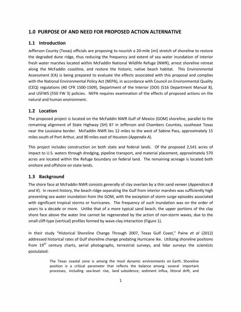
1.3 Background The shore face at McFaddin NWR consists generally of clay overlain by a thin sand veneer (Appendices B and K). In recent history, the beach ridge separating the Gulf from interior marshes was sufficiently high preventing sea water inundation from the GOM, with the exception of storm surge episodes associated with significant tropical storms or hurricanes. The frequency of such inundation was on the order of years to a decade or more. Unlike that of a more typical sand beach, the upper portions of the clay shore face above the water line cannot be regenerated by the action of non-storm waves, due to the small cliff-type (vertical) profiles formed by wave-clay interaction (Figure 1). In their study “Historical Shoreline Change Through 2007, Texas Gulf Coast,” Paine et al (2012) addressed historical rates of Gulf shoreline change predating Hurricane Ike. Utilizing shoreline positions from 19th century charts, aerial photographs, terrestrial surveys, and lidar surveys the scientists postulated:
The Texas coastal zone is among the most dynamic environments on Earth. Shoreline position is a critical parameter that reflects the balance among several important processes, including sea-level rise, land subsidence, sediment influx, littoral drift, and

2
storm frequency and intensity. Because the Texas coast faces ever-increasing developmental pressures as the coastal population swells, an accurate and frequent analysis of shoreline change serves as a planning tool to identify areas of habitat loss, better quantify threats to residential, industrial, and recreational facilities and transportation infrastructure, and help understand the natural and anthropogenic causes of shoreline change.
In regard to the project area and vicinity, “the muddy marshes on the upper Texas coast between High Island and Sabine” present as areas “undergoing significant net retreat,” while “[s]ignificant net shoreline advance [has] occurred adjacent to the jetties that protect dredged channels at Sabine Pass” (Paine et al , 2012).
Figure 1: Vertical Clay Ridges due to Loss of Sand Veneer at McFaddin NWR Shoreline
In a 2014 study, the Texas General Land Office (TGLO) noted shoreline and volumetric changes to Jefferson County from 2005 through 2012. Even four years after the passage of Hurricane Ike (2008), this portion of the Texas coast had not fully recovered and full recovery is not expected due to “lack of natural sediment input and significant transport of sand away from critically eroding areas.” As much of the thin sand veneer overlaying the clay outcroppings was removed during the hurricane, this veneer is not expected to recover, leaving this section of the shoreline more susceptible to ongoing erosion. During the 7-year study period, the cumulative shoreline change in this region was a recession of 141 feet and a rate of change equal to 20 feet per year. The dune system has been decimated over the years by ongoing annual erosion, seasonal storm events, and hurricanes. Shoreline retreat has accelerated from historic rates around -20 feet per year, to as

3
much as -40 feet per year in places. Hurricane Ike flattened much of the remaining beach ridge separating the GOM from the interior marshes, moving a significant amount of sand outside the active profile either seaward onto the submerged continental shelf or landward into the marsh. The loss of sand from the active beach system has eroded the dune crest, thus reducing elevations to the extent sea water now routinely inundates the formerly fresh and brackish marsh in the Refuge interior. The results will be marsh loss on a massive scale and Gulf shoreline retreat measured in miles, rather than in feet, until it reaches one of the busiest segments of the Gulf Intracoastal Waterway (GIWW).
Table 1: Average Volume Change Results of Foredune Zone (LIDAR Comparisons) Net Volume Change per Alongshore Length [CY/FT]
Impact of Ike Recovery Cumulative
(2005-2008) (2008-2012) (2005-2012)
-8.5 -2.9 -11.4
[Source: TGLO, 2014] This project is part of the over-arching Salt Bayou Watershed Restoration Plan (TPWD, 1993). Through interagency coordination, including a Federal shoreline erosion feasibility study (U.S. Army Corps of Engineers [USACE]), SH 87 Restoration Environmental Impact Statement (Federal Highway Administration [FHWA]), and investigation of feasible shore protection alternatives to facilitate SH 87 restoration (Jefferson County, using 2001 Jefferson County Coastal Impact Assistance Program [CIAP] funds), a consensus project has emerged that will reduce the frequency of saltwater inundation of vast areas of sensitive interior wetlands in the Refuge. The initial part of this solution involved the construction of a clay core dune 600-ft landward of the current high water line to slow high tide waters from entering the wetlands.
With the passage of Hurricane Ike exacerbating the existing threats to the marsh, a protection project was developed by the USFWS, in conjunction with Jefferson County and the TGLO, to restore the dune ridge and replenish the beach. The proposed beach replenishment will result in the protection of approximately 20 miles of McFaddin NWR shoreline from high tide events and low to mid energy storm events.
1.4 Purpose and Need for Proposed Action The purpose of the Proposed Action is to restore the longevity of the Chenier beach ridge in a manner which will delay shoreline retreat and prevent breaching of the beach ridge, in all but the most extreme cases, for decades to come. Preventing breaching is paramount to the protection of the McFaddin NWR wetlands. The Proposed Action will reduce the frequency and the extent of sea water inundation in the interior marshes of the McFaddin NWR and restore the shoreline habitat.

4
The Proposed Action is needed to help conserve one of the largest freshwater marshes on the Texas Coast, along with thousands of acres of intermediate to brackish marsh. McFaddin NWR supplies important feeding and resting habitat for migrating and wintering populations of waterfowl. Meeting the habitat needs of McFaddin NWR’s diversity of wetland dependent resident and migratory birds requires maintaining a range of coastal marsh habitat types and sequential stages of the plant community within these marsh types. Providing freshwater inflows and restricting saltwater intrusion are critical to maintaining the Chenier Plain’s historic continuum of fresh, intermediate, and brackish saline marshes. Habitat values for waterfowl, shorebirds and many wading bird species are greatly enhanced in intermediate marshes with early successional plant communities containing several perennial and annual plant species (primarily grasses and sedges) which provide important food resources, and where disturbance reduces the height and/or density of vegetation.
McFaddin NWR is part of the Salt Bayou ecosystem, the largest contiguous estuarine marsh complex in Texas. This ecosystem is approximately 139,000 acres in size within a Chenier Plain landscape that includes freshwater to estuarine marsh, coastal prairie grasslands, tidal flats, creeks and basins and associated aquatic vegetation. This diversity of communities creates an extremely productive complex for an array of fish and wildlife resources.
In 2000, The Salt Bayou Marsh Workgroup, comprised of Federal, State, and County level government representatives and wetland conservation Non-Government Organizations (NGOs), assembled to collaborate on a plan that would “…describe and address the importance of the Salt Bayou system’s ecological functions, to discuss natural and man-made causes of decline, and to propose a plan of action that would maintain ecological functions and values or reverse their decline.” In May 2013, this technical stakeholder group completed the Salt Bayou Watershed Restoration Plan, a document reflecting the Salt Bayou Workgroup’s understanding and knowledge of this ecosystem, as well as consensus on strategies to improve conditions of the Salt Bayou system. The final plan also represented a consensus of the workgroup members on a strategy to collectively improve conditions in the Salt Bayou system. One of the workgroup’s recommendations was to restore the historic beach ridge where it was missing from High Island to Sabine Pass.
The clay core berm project currently underway on the Refuge directly responds to this recommendation and, when completed, will minimize the frequency of high tide overwash events to a periodicity of multiple years. This would allow the marsh ecosystem to stabilize after high salinity events and provide a productive vegetation community and habitat that supports freshwater dependent species. The proposed beach restoration will further protect both the clay core berm and McFaddin NWR against sea water inundation into the interior marshes, as well as return much needed sediments to the local littoral system. Additionally, the Refuge will be able to fully function as a natural protective buffer between the GOM and GIWW, protecting Jefferson and Chambers County residents, natural resources, and infrastructure.
The major elements of the proposed beach restoration have been documented in a significant engineering analysis performed by Jefferson County using federal CIAP funds appropriated in 2001. In

5
addition, USACE actively studied the McFaddin NWR coast, in partnership with Jefferson County, between 2001 and 2009, as part of a feasibility study for erosion response. In 2003, a test section consisting of imported beach sand and a constructed dune was put in place on McFaddin Beach by USACE as a demonstration project. This test project yielded valuable information about the potential performance of the proposed project.
Regulatory Compliance
Pursuant to NEPA, as amended, this EA has been prepared for Jefferson County to evaluate the effects associated with this proposal and complies with NEPA in accordance with CEQ Regulations for Implementing NEPA [40 Code of Federal Regulations (CFR) Section (§) 1500-1508]. In January 1997, USFWS published the NEPA Reference Handbook (550 FW 3) and in May 2004, the Department of the Interior published Chapter 8 of the Department Manual, Managing the NEPA Process (516 DM 8). These publications provide guidelines for implementing procedures for all elements of NEPA within the USFWS.
The National Wildlife Refuge System (NWRS) Improvement Act of 1997 states, “the mission of the National Wildlife Refuge System is to administer a national network of lands and waters for the conservation, management, and where appropriate, restoration of the fish, wildlife, and plant resources and their habitats with the United States for the benefit of present and future generations of Americans” (16 USC 668 dd [a]).
In addition, this EA represents compliance with applicable Federal statutes, regulations, Executive Orders, and other compliance documents, including the following:
• American Indian Religious Freedom Act of 1978 (42 U.S.C. 1996) • Archaeological Resources Protection Act of 1979 (16 U.S.C. 470) • Clean Air Act of 1972, as amended (42 U.S.C. 7401 et seq.) • Clean Water Act of 1972, as amended (33 U.S.C. 1251 et seq.) • Coastal Barrier Resources Act • Endangered Species Act (ESA) of 1973, (ESA) as amended (16 U.S.C. 1531 et seq.) • Estuary Protection Act • Executive Order 12114, Environmental Effects Abroad of Major Federal Actions, 1979. • Executive Order 11988, Floodplain Management, 1977. • Executive Order 11990, Protection of Wetlands, 1977. • Executive Order 12088, Federal Compliance with Pollution Control Standards, 1978. • Executive Order 13158, Marine Protected Areas, 2000. • Executive Order 13186, Responsibilities of Federal Agencies to Protect Migratory Birds, 2001. • Executive Orders 11514/11991, Protection and Enhancement of Environmental Quality, 1970. • Executive Order 12898, Federal Action Alternatives to Address Environmental Justice in Minority
Populations and Low Income Populations, 1994. • Executive Order 11593, Protection and Enhancement of the Cultural Environment, 1971.

6
• Executive Order 13352, Facilitation of Cooperative Conservation, 2004. • Executive Order 12856, Federal Compliance with Right-to-Know Laws and Pollution Prevention
Requirements, 1993. • Fish and Wildlife Coordination Act of 1958, as amended (16 U.S.C. 661 et seq.) • Magnuson-Stevens Fishery Conservation and Management Act of 1976, as amended • Marine Mammal Protection Act • National Environmental Policy Act (NEPA) of 1969, as amended (42 U.S.C. 4321 et seq.) • National Historic Preservation Act of 1966, as amended (16 U.S.C. 470 et seq.) • Native American Graves Protection and Repatriation Act of 1990 (25 U.S.C. 3001 et seq.) • National Pollutant Discharge Elimination System, as amended (33 U.S.C. 1251 et seq.) • National Wildlife Refuge System Improvement Act of 1997 • Regulations for Implementing the Procedural Provisions of NEPA (40 CFR 1500 et seq.) • Resource Conservation and Recovery Act
Further, this EA reflects compliance with applicable State of Texas and local regulations, statutes, policies, and standards for conserving the environment and environmental resources such as water and air quality, endangered plants and animals, and cultural resources. Additionally, consultation with the following agencies was conducted:
• U.S. Fish and Wildlife – Ecological Services • U.S. Army Corps of Engineers – Historical and Archeological Preservation • Texas Historical Commission – Archeology Division • National Oceanic and Atmospheric Administration – National Marine Fisheries • Texas General Land Office – Asset Inspection, Coastal Erosion Planning and Response Act
Division, Coastal Construction Services • Texas Parks and Wildlife Department – Marine Fisheries • U.S. Environmental Protection Agency – Coastal Ecology
1.5 Public Involvement and Issues Identified In February 2016, the County will announce the opening of a 30-day comment period for an EA prepared to evaluate alternatives for the construction of a restored dune ridge and beach nourishment to facilitate reduction in shoreline retreat, as well as reduce the frequency and extent of sea water inundation in the interior marshes of McFaddin NWR. This 30-day comment period is anticipated to begin within a week of the official announcement and, in late February, the EA will be made available for public comment. The County will provide access to the EA on their website, via the County Clerk’s office, as well as publishing a news release and sending notice to potential interested parties announcing the public comment period for development of this EA. USFWS will also post the Draft EA on the McFaddin NWR website.
Concurrent with the public comment period for the Draft EA, the U.S. Fish and Wildlife Service (USFWS) will issue a Draft Compatibility Determination for the Beach Ridge Restoration for public

7
review/comment. NWR’s are required to determine the compatibility of any proposed use with the mission of the NWRS and the purpose for which a particular refuge was established. Hard copies of the Compatibility Determination are available at the USFWS Office in Sabine Pass, Texas, or from the Refuge website at http://www.fws.gov/refuge/mcfaddin/.
2.0 ALTERNATIVES ANALYSIS
2.1 Project Criteria The primary goals of this project are: to prevent saltwater intrusion into McFaddin NWR along the shoreline due to tides and storm water levels occurring more frequently than the 5 year return interval (20% chance of occurrence in a given year); to decrease beach erosion during storm events and provide localized sediment increases to the littoral system; and to re-create dune/beach habitat.
2.2 Alternatives Considered and Selection Criteria The alternatives analysis conducted for this project included consideration of the no action alternative, borrow source alternatives, sediment delivery alternatives, and construction alternatives. A brief summary of the alternatives is presented below.
2.2.1 No Action Alternative The No Action Alternative will result in the conversion of tens of thousands of acres of refuge habitat into salt marsh and likely open water habitat. In recent years, there has been more than 200 acres of marsh habitat are lost annually. Historically, it has required an entire growing season or longer for these marshes to recover following sea water inundation as subsequent rainfall helps flush the system and reduce salinities. The berm currently being constructed will help marsh recovery and decelerate marsh die off, but in order for McFaddin NWR to benefit from the maximum armoring potential, the Chenier beach ridge needs to be restored as well. Without the combination of both efforts, increased salinities will ultimately have significant negative impacts to most coastal marsh species, including estuarine fisheries species as water conditions deteriorate in one of the largest estuaries on the Texas coast.
Cascading effects include reduced biomass production, collapse of the root zone leading to shallow surface subsidence, and loss of organic soils leading to rapid conversion to open water. Aquatic habitats will decline in value as increased salinities levels remain. Open water areas will increase in size, leading to increased turbidity and loss of aquatic vegetative communities. As emergent marsh communities are lost in the conversion of marsh to open water, species utilizing the interior marshes will be displaced to more suitable habitat, if available. In addition to hundreds of acres per year converting to open water at the Gulf shoreline, the interior of the marsh will open up and eventually connect to the GOM. Examples of this progression are evident in Southern Louisiana.
The No Action Alternative will also result in the continuation of increased shoreline retreat along the McFaddin Beach coastline. In addition, clay-based chenier ridges, already exposed along many thousands of shoreline feet, are increasing turbidity in the water column through suspension of small silt

8
and clay particles from direct wave energy impacts. This increase in suspended sediments can bury benthos within the nearshore zone.
2.2.2 Borrow Source Identification The borrow source identification process was a two-step method involving both a preliminary and final investigation. The purpose of the investigation was to locate a sand source with sufficient quantity and quality of sediments to meet the needs of the project.
The preliminary investigation was conducted in 2014 and consisted of a review of historical field investigations and literature aimed at identifying sites with a high probability of containing useable sediments. The literature investigation considered both nearshore and offshore regions, with a focus on locating beach quality sediments buried in fluvial channels. The final investigation, conducted in 2015, was designed to narrow the search and focus on delineating the site or sites identified in the initial investigation for use as borrow sites. Based on field investigations by Coastal Planning and Engineering, Inc. (CPE), USACE, Bureau of Economic Geology (BEG), and others, five possible offshore sand source locations were identified within a reasonable proximity to the proposed project area (Appendix C).
2.2.2.1 Borrow Source Alternatives Both onshore and offshore borrow sites were considered for this project. Onshore, commercial sources would incur costs of several dollars per cubic yard resulting in millions of dollars of additional cost to the project whereas an offshore material source is a state-owned resource and adds zero cost to the project. Therefore, based on costs of both materials and transportation, and impacts to the local environment, onshore site alternatives were not pursued further (see also section 2.2.4). Of the five offshore borrow site alternatives considered, four of the sites were deemed nearshore and one alternative was considered an offshore site. These Target Area (TA) locations are shown in the following table.
Table 2: Borrow Source Alternatives
Alternative Location Distance from project (miles)
TA 12 Nearshore 9 TA 13 Nearshore 9 TA 14 Nearshore 9 TA 15 Nearshore 1.5 TA 16 Offshore 10
TAs 12-14 were initially believed to contain subsurface sand deposits with overburden at the northern sections. A sand layer, caused by fault uplift in the southern sections, was located on the surface. However, CPE’s 2006 survey located a previously unknown pipeline just north of TA 12. Since this pipeline extends westward, it prohibits the use of the northern sections of TAs 13 and 14. In addition, geophysical data of the fault-uplifted area and paleofluvial channel identified in the southern sections proved to have sediments incompatible with the project purpose (Finkl et al. 2007).

9
Based on the literature review, and previous physical surveys, it was determined the offshore site (TA 16) be dismissed for two reasons. First, although the target area is larger than the nearshore TAs and, therefore, could promise greater sand quantities, the distance from the project site greatly reduces cost efficiency. Additionally, while initial geophysical study presented potential sand volumes in a complex system of deep paleoriver channels, further data collection proved the sediments in these channels to be incompatible with beach nourishment (Finkl et al. 2007).
2.2.2.2 Preferred Borrow Source Alternative The above findings resulted in focusing the final physical investigation in and around TA 15. This investigation assumed a need for a minimum of four million CY of sediment. Field work associated with the final investigation included a two-step process with sub-bottom seismic data collection and review, followed by sediment sampling and analysis. Approximately 145 line-miles of geophysical exploration to delineate the site and identify cultural resources were conducted in addition to the collection of more than 30 vibracore samples at about 1000-ft spacing (Appendices J and L).
Sediments tested at this location proved compatible with those tested during 2015 beach surveys at McFaddin NWR (Appendix L).
Impacts to the local environment are outlined in Section 4 (see also Tables 5 and 6). Adverse effects to the offshore environment would be localized and temporary (see also Table 7). Adverse effects to any T&E species would be minimized based on the conservation measures outlined in Section 5.
2.2.3 Construction Alternatives Initial construction considerations for McFaddin NWR shoreline stabilization included structural options, dune ridge restoration, and a combination of both options. Each of these was screened under the following parameters:
• Potential environmental impacts • Potential impacts to recreation and navigation • Cost • Delivery time
2.2.3.1 Construction Alternative A
Alternative A involves stabilizing the shoreline with structures. Structural options could include groins, revetments, and offshore breakwaters. Groins, built perpendicular to the shoreline, would help to slow the alongshore transport and eventually aid in the seaward growth of the beach. Revetments could be used to “armor” the upper berm and dune ridge from wave attack. Breakwaters built parallel to the shoreline would reduce wave energy and create convergence zones for sediment to build in their wake. However, since the project aim is to restore the natural protective dune ridge system and return sediments to the natural coastal system, these alternatives do not meet project objectives, are cost prohibitive, and would have long term impacts to the local environment.

10
2.2.3.2 Construction Alternative B Alternative B involves the re-building of the dune line and beach face with material similar to the native sand. This alternative would utilize sand from a source outside the Refuge to re-create historic dune heights and beach widths to reduce shoreline retreat and protect the sensitive inland marshes. Sediments could be delivered to the Refuge by a number of methods (Section 2.2.4). Dune plantings would be conducted to increase dune stability.
2.2.3.3 Construction Alternative C Alternative C is a combination of Alternatives A and B. The use of both structures and imported sediments would enhance the results desired from Alternative A. An infusion of sediments, in conjunction with the shoreline structures, would provide a “jump-start” to the desired outcome, that is, gradual growth of the dune ridge and beach face. However, since the project aim is to restore the natural protective dune ridge system and return sediments to the natural coastal system, structural alternatives do not meet project objectives, are cost prohibitive, and would have long term impacts to the local environment.
2.2.3.4 Preferred Construction Alternative Evaluation of the three construction alternatives, and the no build alternative, was conducted using the criteria listed above. Results of that evaluation are presented below:
Table 3: Construction Alternatives Comparison
Environmental Recreation &
Navigation Delivery
Alternative Impacts Impacts Cost Time
A high medium high high
B medium low (temporary) medium medium
C high medium high high
No Action high high N/A N/A
Construction Alternative B, the Preferred Construction Alternative, was selected based on reduced costs, construction time, environmental impacts, and to increase recreational usage along the McFaddin NWR shoreline. The Preferred Alternative will also re-create lost dune and beach habitat, as well as return needed sediments to the near shore littoral system. Impacts to the local environment are outlined in Section 4 (see also Tables 5 and 6). Adverse effects to the shoreline environment would be localized and temporary (see also Table 7). Adverse effects to any T&E species would be minimized based on the conservation measures outlined in Section 5.

11
2.2.4 Sediment Delivery Alternatives Three sediment delivery alternatives were considered for delivering the sediments to the project site. An initial material volume of four million CY was assumed for all three sediment delivery alternatives. The delivery methods were evaluated based on the following:
• Potential environmental impacts • Potential impacts to recreation and navigation • Cost estimate • Delivery time
In addition, limiting the construction footprint within the McFaddin NWR is paramount.
2.2.4.1 Delivery Alternative A Alternative A involves trucking sand into the Refuge along the shoreline from a land-based sand source. A two-lane temporary roadway would need to be constructed within the Refuge for the purpose of delivering truckloads of sand to the construction site(s). Depending on the location of the sand source, entry to the Refuge could take place near the end of Hwy 87, about 12 miles west of Sabine Pass, or from the TX- 87/TX-124 intersection near High Island in Galveston County. However, due to the need for a two-lane temporary roadway, the limited volume of material that can be conveyed per truck load, and the number of trips required to complete the 20-mile project, this alternative is not feasible based on environmental impact, cost, or delivery time. Additionally, current construction of the clay core berm has shown the use of a temporary road installation would not be feasible. Heavy construction equipment on sturdy mats routinely sinks into the soft soils saturated by rainwater and high tides.
2.2.4.2 Delivery Alternative B Alternative B involves trucking the sediment from a land-based sand source to a handling station by the NWR western entrance near the TX-87 and TX-124 intersection. The material would then be placed into a hopper, mixed with water to form a slurry, and pumped via pipeline and booster stations along the shoreline to the construction site(s). While this method has the advantage of significantly reducing the traffic load within the Refuge, and some delivery time, combining trucking and pipeline delivery methods drastically increases project costs. Subsequently, this alternative was not explored further.
2.2.4.3 Delivery Alternative C Alternative C involves utilizing sediments from an offshore sand source. The material would be dredged using a cutter-head dredge from the borrow area and transferred to the shore via submerged pipeline. Once onshore, the material would be pumped along the shoreline to the local construction areas and graded to the required construction template with heavy equipment. Based on conversations with State and Federal archeologists and biologists, impacts to cultural and biological resources can be mitigated by allowing for a maximum of six pipeline corridors between dredge/pipeline connections offshore and

12
the coastline. An example is shown in Figure 2. This method also reduces the need for extra booster pumps by limiting the along-shore pipeline reach on either side of the shoreline connection points.
Figure 2: Example of Possible Pipeline Routes
Fine-grained sediment from the borrow source (i.e. those with a percentage of fines > 20%) known as ‘overburden’ would be placed in a grade restoration area between the dune line and existing clay core berms (Appendices H and I). Current conditions in these areas slope toward the depleting wetlands causing water to become trapped against the berms. Standing water against the base of the berms can increase plasticity of the clay, and also the probability of berm failure during a tropical event. The trapping of seawater also increases salinities as evaporation occurs, creating hyper-saline environments detrimental to the natural vegetation – as is currently the case. This condition is causing the loss of salty prairie habitat dominated by Spartina spartinae with the conversion to a lower quality wetland type in the form of a non-vegetated salt flat. The deposition of fine sediments will create soil similar to what is present on the salty prairies and help direct water back towards the GOM. The result would be self-mitigating measures that will cause water currently being trapped in this area to flow toward the GOM, stop the conversion/loss of quat (vegetation), and allow salty prairie habitat to re-establish.

13
Overburden sediments not needed for grade restoration would be placed in a secondary placement location approximately ½ mile seaward of the proposed borrow area (Appendices B and H).
2.2.4.4 Preferred Delivery Alternative Because the no build alternative would not meet the need and purpose of the project, or require sand transport, it was not evaluated. The other three alternatives were evaluated according to the criteria stated above. Results of the evaluation are presented below:
Table 4: Sediment Delivery Alternatives
Alternative Environmental
Impacts
Impacts to Recreation and
Navigation Cost Delivery Time A high low high high
B high low high high C medium low (temporary) medium medium
Delivery Alternative C, the Preferred Delivery Alternative, was selected based on low to medium impacts of all criteria evaluated. The Preferred Alternative is also the only one that does not require construction of temporary roads which could permanently impact habitats within the Refuge. Impacts to the local environment are outlined in Section 4 (see also Tables 5 and 6). Adverse effects to the local environment would be localized and temporary (see also Table 7). Adverse effects to any T&E species would be minimized based on the conservation measures outlined in Section 5.
2.2.5 Implementation of the Preferred Alternatives The proposed project is a combination of the preferred alternatives for beach ridge restoration measure, material source, and delivery method. The project can be described as shoreline nourishment using material dredged from an offshore sediment source by a cutter head-suction dredge and hydraulically pumped to shore as sediment-water slurry through a temporary pipeline. A general description of the means and methods employed to implement the project follows.
Project Management Activities – Personnel management, safety, environmental protection, procurement, direction of work, quality control, measurement, coordination with owner re/engineer, filed survey. Equipment – office trailer (shared), power supply (generator), pickup truck, all-terrain vehicle, Global Positioning System (GPS) equipment, grade marking equipment (such as metal conduit and survey flagging). Note: By law, Texas beaches are open to the public. From the Texas Natural Resource Code, “beach” means state-owned beaches to which the public has the right of ingress and egress bordering on the seaward shore of the Gulf of Mexico or any larger area extending from the line of mean low tide to the line of vegetation bordering on the Gulf of Mexico if the public has acquired a right of use or easement to

14
or over the area by prescription, dedication, or has retained a right by virtue of continuous right in the public (as amended in 2013). The active construction zone will be off limits to the public. This will temporarily prevent through traffic on the beach from either the east or west Refuge entrance. Off-road access into the sensitive wetland areas of McFaddin NWR for the purpose of avoiding temporary construction closures is not allowed.
Logistics Activities – personnel transport, equipment maintenance, fueling, emergency response. Equipment – office trailer (shared), pickup trucks, all-terrain vehicles, fuel truck/trailer, flatbed trailer, temporary fencing. Offshore Dredging Activities – Mobilization, positioning, dredge operation, dredge maintenance/repair, fuel transfer, personnel transfer. Equipment – dredge plant, workboats, skiffs, anchors, mooring cables, tugboats, booster pumps, floating or jack-up barge, work barge(s), anchor barge. Methods – A rotating cutterhead attached to a suction pipe is lowered to the seafloor. Material entering the pipe passes through the dredge pump(s) and is transported via pipeline to the shoreline. To remove material, the dredge (and rigid suction pipe) will swing side to side by applying tension on mooring wires affixed to anchors. As material is depleted, the dredge will progress forward potentially using a combination of spuds, mooring wires, and tender tugs. Depending upon the distance to the temporary construction area(s), booster pumps may be required. Pipeline Management Activities – Mobilization, submerged pipe connection/placement, floating pipe connection/placement, onshore pipe connection/placement, discharge control, pipeline monitoring, pipeline maintenance/repair. Equipment – workboats, skiffs, small and large tracked vehicles, wheeled vehicles, crane, anchor barge, tugboats. Methods – Pipeline may arrive to project site by truck or barge. Pipe intended for offshore use will be mobilized to the water-side staging area and connected to meet the project length requirements. These lengths of pipe would be rafted and towed to the pipeline corridor in one or more segments. Segments will then be connected, sunk, and marked according to U.S. Coast Guard navigation standards. The submerged pipeline will extend to the shoreline where it will be met by heavy equipment which will connect the shoreline pipe. As the project progresses, additional pipe will be added along the shoreline to transport sediment down the beach. All pipeline segments will be routinely monitored by the contractor for signs of damage or deterioration. Material Placement Activities – Ground preparation/debris removal, dredged material receiving (pipeline), discharge control, return water management, grading, coordination with dredge, progress and payment surveying.

15
Equipment – bulldozers, graders, other small and large tracked and wheeled vehicles, office trailer (shared), port-o-potty, temporary fencing, all-terrain vehicle, GPS equipment, grade marking equipment, (such as metal conduit and survey flagging). Methods – Heavy equipment operators will create temporary earthen containment dikes, which will channelize the flow exiting the dredge pipe. As this flow runs along the beach, sediment will settle out within the project template and effluent will return to the ocean. As sediment builds up in front of the pipe, heavy equipment will grade the sediment to meet the project template. This may be done using grade markers which are set by survey personnel for guidance. This is a continuous process interrupted only by the need to shut down due to dredge maintenance, re-positioning, fueling, adding shoreline pipe, or an emergency. Constant communication is required between shore-crew, dredge crew, and potential booster pump operators. Acceptance and Closeout Activities – Measurement surveying, aerial photographs, dune planting (if specified). Equipment – office trailer (shared), pick-up trucks, all-terrain vehicles; dune planting: fuel, truck/trailer, flatbed trailer, temporary fencing. Monitoring Activities – Construction oversight (owner rep/engineer), critical habitat/endangered species patrol, archeological (cultural resources) patrol, as required. Equipment – office trailer (shared), pickup trucks, all-terrain vehicles. Methods – Construction and engineering reps will meet periodically to discuss work completed, work to be completed, issues identified, clarifications/directions, etc. Designated environmental monitors will survey the immediate project area, a 100-ft buffer zone, and access routes daily as deemed necessary, and are responsible for communication and reporting of endangered species issues during construction.
3.0 AFFECTED ENVIRONMENT
McFaddin NWR is one of 560+ refuges comprising the National Wildlife Refuge System, a national network of lands and waters set aside for the benefit of wildlife. Established in 1980, the 58,861-acre NWR consists of the largest remaining freshwater marsh on the Texas Coast and thousands of acres of intermediate to brackish marsh. McFaddin NWR supplies important feeding and resting habitat for migrating and wintering populations of waterfowl. McFaddin NWR is part of the Salt Bayou marsh system which comprises the area west of Sabine Lake and the Sabine-Neches Waterway, and south of the GIWW. This system consists of a continuum of saline tidal to freshwater microtidal systems.
This refuge is located along SH 87 in the southeastern portion of Texas, near the Louisiana border. McFaddin NWR lies approximately 15 miles south of Port Arthur, 90 miles east of Houston, and 12 miles west of Sabine Pass. McFaddin NWR is bounded on the south by the Gulf of Mexico, on the east by Texas Parks and Wildlife Department (TPWD) property and private land, on the west by private land near High Island, and both the GIWW and private property to the north.

16
McFaddin NWR lies within a bio-geographical region known as the Chenier Plain (Gosselink et al. 1979). Geographically, the Chenier Plain region extends from Vermillion Bay in southwestern Louisiana to East Galveston Bay in southeastern Texas. A distinguishing feature of the region is the presence of cheniers, ridges representing the ancient Gulf shorelines which are generally aligned parallel to the Gulf or as fan-shaped alluvial deposits at the mouths of rivers. The higher cheniers support woody vegetation, hence the name chenier, a French word which means “place of oaks”. Cheniers are more prevalent in Louisiana than in Texas, perhaps because of the alignment of the Gulf shoreline and its proximity to the Mississippi River, the Chenier Plain region’s primary sediment source. Given the region’s significant annual rainfall, wetlands isolated from the Gulf by the cheniers and ridges developed into highly productive and diverse freshwater coastal marsh habitats. The existing beach ridge on McFaddin NWR was produced by those alluvial deposits and is responsible for the existence of the freshwater marshes within Salt Bayou.
3.1 Physical Environment of McFaddin NWR Beach
3.1.1 Air Quality The Texas Commission on Environmental Quality (TCEQ) is the state agency responsible for regulating air quality in Texas. Non-attainment areas are areas which have failed to meet Federal standards for ambient air quality. McFaddin NWR is within Beaumont-Port Arthur (BPA) area which is designated as nonattainment for eight-hour ground-level ozone air quality standard for Texas. This BPA area includes Hardin, Jefferson, and Orange counties. The major sources of air pollution in this region are petroleum production, chemical production, shipping, and agriculture.
Burning is widely used as an agricultural management tool in the region to improve pasture and control undesirable vegetation. The TCEQ administers the Outdoor Burning Rule (Title 30, Texas Administrative Code, Sections 111.201 – 111.221), which regulates prescribed burning within the state. TCEQ is responsible for issuing authorization to prescribed burn, defining the conditions when burning will be permitted, and determining what materials may be burned.
3.1.2 Geology and Soils The Chenier Plain Region is part of a recent geologic plain. Most soils within McFaddin NWR are remnants of ancient floodplains and Gulf beaches and consist of old alluvium and marine sediment deposited by ancient streams and the Gulf. These deposits are mostly clayey and sandy soils and exhibit a wide range in textural differences due to their origin within historic floodplain systems (U.S. Department of Agriculture (USDA), 1976). McFaddin NWR is located within the 100-year floodplain. The soil types, both acidic and alkaline, are poorly drained with slow permeability, moderate to high salinity, and a high shrink-swell potential (USDA 1960, USDA, 1976).
Paine, et al (2012) described the principal “natural geomorphic features and shoreline types” for the project area as: (1) the generally shore-parallel beach ridges and intervening swales in the Sabine Pass

17
area, [and] (2) thin, discontinuous sandy beaches that veneer the retreating low, muddy marsh deposits between High Island and Sea Rim State Park.
Coastal land soils are found on the lower slopes of the sandy ridges and along the Gulf. These soil types form the Sabine-Coastal land association. The shoreline of McFaddin NWR is made up of the Sabine-Coastal land association and the Saltwater marsh-Tidal association. Coastal soils generally consist of deep, dark colored and slightly acidic sands. As remains of ancient Gulf of Mexico beaches, they are relatively low in nutrients. Specifically, the coastal soils differ dramatically in pH, color, texture, available water capacity, and drainage. The Gulf beach within the McFaddin NWR is predominately exposed clay with a thin overlay of sand, reflecting a recent scarcity of sand. Clay outcroppings from the underlying strata have been exposed along large areas due to erosive events such as hurricanes, tropical storms, and winter frontal passages.
The U.S. Geological Survey (USGS) topographic quadrangle maps were reviewed to determine elevations and slopes within the project area. This project is located in the Mud Lake, Star Lake, South of Star Lake, Clam Lake, and Sabine Pass USGS 7.5-minute quadrangles (1:24000). The elevation in the proposed project area is approximately 0 to 5 feet above mean sea level. The following soil types are present within the proposed site area (Appendix E):
Barnett mucky peat (BcA), 0 to 1 percent slopes, frequently flooded, tidal Barnett silty clay loam (BeA), 0 to 1 percent slopes, frequently flooded, tidal Leerco muck (LvA), 0 to 1 percent slopes, frequently flooded, tidal Veston fine sandy loam (VeA), 0 to 1 percent slopes, frequently flooded, tidal
3.1.3 Water Resources The historical pattern of hydrology in the Chenier Plain region was critical to the building processes that created and maintained the diversity of its coastal wetlands. Frequent flooding over low bayou banks and large volumes of rainwater sheet flowing slowly across coastal prairies and marshes provided nutrients, sediments, and freshwater to marsh systems. Natural drainage allowed a cyclic pattern of drying and flooding under which wetland plants evolved and adapted. Over the past 5,000 years, the Chenier Plain region was predominately a freshwater coastal marsh system, but contained a continuum of coastal marsh types associated with a natural salinity gradient. This continuum of freshwater, intermediate, brackish, and saline wetlands supported a diversity of floral and faunal communities.
Modifications to the natural hydrological systems have affected ecological and geological processes critical to the long-term integrity of coastal ecosystems in the Chenier Plain region. In general, the primary human induced activities that have affected coastal wetlands across the Chenier Plain in Texas include dredging of the Houston Ship Channel for navigation, canalization of the Trinity River, dredging of the Sabine River and Neches River to form the Sabine Neches Waterway, construction of the GIWW into Galveston Bay, as well as construction of smaller navigation canals and drainage canals, as well as oil, gas, and groundwater extraction. The consequences of these activities have resulted in various

18
ecological responses, some of which are directly responsible for the onset of others (White and Tremblay, 1995).
McFaddin NWR is located within the East Galveston Bay and Sabine Lake Watersheds. The existing hydrology of McFaddin NWR consists of a series of shallow ponds and tidal bayous, sloughs, and canals which drain primarily to the GIWW. Portions of the McFaddin NWR are subject to daily tidal flows, however, high storm tides and hurricanes are capable of flooding the entire area. Numerous marsh flats, small potholes, and shallow marsh ponds are found within the McFaddin NWR. McFaddin NWR contains water control structures, levees, and weirs.
3.2 Biological Environments of McFaddin NWR Beach
3.2.1 Benthic Habitats Beach fauna are typically mobile and adaptable to the changing conditions caused by tides and exposure to air. The abundance of beach benthos, therefore, tends to be relatively low. Species present are usually cryptic species, such as crabs, which emerge from the sand at night or when the tide is high, but only in the small number of areas where a significant sand veneer is present over the clay ridges. The Bureau of Ocean Energy Management (BOEM) found that biological diversity of the benthic community, with all its existing phyla represented, is mainly composed of fauna that inhabit interstitial spaces (2012). Species abundance is typically determined by the speed of tidal retreat (or ebb current), which is rapid in the GOM (NOAA, 2014).
3.2.2 Vegetative Habitats Vegetative habitats within McFaddin NWR are primarily determined by soil type, hydrology and salinity. These vegetative habitats are important for waterfowl, shorebirds, wading birds, and other water birds wintering on or migrating through the upper Texas Gulf Coast.
3.2.2.1 Upland Habitats Most upland habitats within the project area are comprised of salty prairie habitat classified as seasonal wetlands. Other upland habitats found in McFaddin NWR include beach ridges/dunes and small coastal woodlots located on the Chenier ridges or on elevated features (both natural and manmade), including bayou banks and levees. Upland habitats present within McFaddin NWR include salt prairies, remnant tall-grass prairies, and small remnant woodlands. Typical woody vegetation present in coastal woodland areas includes red mulberry, hackberry, Chinese tallow, live oak, southern wax myrtle, yaupon holly, and sweetgum. These woodlots are heavily used rest areas during spring and fall migrations by neotropical migrant birds. Salty prairies occur as elevated ridges interspersed within marsh habitats. Remnant stands of tall-grass coastal prairies occur in the northern-most sections of the Anahuac NWR.

19
3.2.2.2 Wetland Habitats McFaddin NWR consists of the largest remaining freshwater wetlands on the Texas Coast with tens of thousands of acres of intermediate to brackish wetlands. The entire area has degraded over the years, primarily due to saltwater intrusion and subsidence. This degradation has significantly reduced the amount of emergent vegetation which provides the foundation for fisheries, birds, amphibians, reptiles, and mammals inhabiting the marsh. Scouring storm surges and other impacts from recent hurricanes have further degraded this wetland complex. Once coastal wetlands lose their vegetation, their value to wetland-associated wildlife is also degraded.
The various wetland habitats within McFaddin NWR are classified as estuarine, palustrine, and lacustrine wetlands (USFWS, National Wetlands Inventory [NWI]) (Appendix D). Wetland habitats within the project area include the beach which is classified as a Marine Intertidal Unconsolidated Shore.
3.2.3 Wildlife Habitats The nearshore Gulf of Mexico and Chenier Plain region provides important habitats for numerous fish and wildlife species, including over three hundred documented avian species. According to TPWD, over 75 species of fresh water fish, and over 400 salt and brackish water species occur in the marshes, bays, bayous, and Gulf of Mexico waters on and adjacent to the McFaddin NWR.
3.2.3.1 Wintering and Resident Waterfowl One of the primary objectives of McFaddin NWR is to provide quality habitat for wintering waterfowl. The McFaddin NWR is part of the southern terminus in the U.S. for most of the ducks and geese in the Central Flyway, and some waterfowl from the Mississippi, Atlantic, and Pacific Flyways also winter here. The 2004 mid-winter waterfowl survey for the Central Flyway indicated 7,901,489 waterfowl used the Central Flyway. Of those birds, 5,110,022 waterfowl (65%) wintered in Texas. The coastal marshes, wet prairies, rice fields and moist soil units of McFaddin NWR are used by 27 species of ducks and five species of geese.
The USFWS conducts aerial waterfowl surveys monthly from September through March on national wildlife refuges on the Texas Gulf Coast. The most common duck species observed were green-winged teal (Anas crecca), gadwall (Anas strepera), northern shoveler (Anas clypeata), blue-winged teal (Anas discors) and northern pintail (Anas acuta). Snow geese (Chen caerulescens) are the principal goose species found in McFaddin NWR. Other geese include greater white-fronted (Anser albifrons) and Ross’s geese (Chen rossii). “White-cheeked” type geese are commonly counted on McFaddin NWR, most of which are presumed to be cackling geese (Branta hutchinsii).
Several of the 27 species of waterfowl found on McFaddin NWR are listed by the USFWS’ Migratory Bird Office as a “Game Bird Below Desired Condition” (USFWS, 2004). They include: canvasback (Aythya valisineria), mallard (Anas platyrhynchos), mottled duck (Anas fulvigula), northern pintail, redhead (Aythya americana), ring-necked duck (Aythya collaris), greater scaup (Aythya marila), lesser scaup

20
(Aythya affinis), and wood duck (Aix sponsa). Snow goose and Ross’s goose are listed as “Over Abundant”.
Essentially non-migratory, the mottled duck is tied to coastal habitats for its entire life cycle. Mottled ducks are year-round residents in fresh, intermediate and brackish marshes as well as suitable agricultural areas near McFaddin NWR. They typically nest in gulf and marsh-hay cordgrass on dryer areas and utilize adjacent wetlands for raising broods. The Upper Texas Gulf Coast, including McFaddin NWR, has historically been considered the core of mottled duck habitat in Texas. Wetland and grassland habitats and rice agricultural lands continue to be extremely important to the Western Gulf Coast Mottled Duck population.
3.2.3.2 Shorebirds, Wading Birds, Marsh, and Waterbirds The tidal flats, beaches, and marshes on McFaddin NWR provide shallow water feeding, breeding, and resting habitat for numerous shorebirds, wading birds, and other marsh and waterbirds. Thirty-two species of shorebirds regularly occur on McFaddin NWR, ten of which are considered ‘highly imperiled’ or of ‘high concern’ under the U.S. Shorebird Conservation Plan (Brown et al. 2000).
Shorebird counts are conducted along the Texas Coast between March 22 and May 17 during two week intervals. The most abundant species observed during the surveys are typically American avocet (Recurvirostra americana), western sandpiper (Calidris mauri), long-billed and short-billed dowitchers (Limnodromus scolopaceus and L. griseus, respectively), semipalmated sandpiper (Calidris pusilla), pectoral sandpiper (Calidris melanotos), black-bellied plover (Pluvialis squatarola), dunlin (Calidris alpina), sanderling (Calidris alba), willet (Catoptrophorus semipalmatus), semi-palmated plover (Charadrius semipalmatus), least sandpiper (Calidris minutilla), and snowy plover (Charadrius alexandrinus). Common nesting shorebirds species within McFaddin NWR include the willet, killdeer (Charadrius vociferus) and black-necked stilt (Himantopus mexicanus).
Colonies of nesting birds including least terns (Sterna antillarum) and black skimmers (Rynchops niger) occur on beaches, washover terraces, and occasionally on man-made sites such as oil and gas well pads. Within McFaddin NWR, nesting wading, marsh and waterbird species include least bittern (Ixobrychus exilis), purple gallinule (Porphyrula martinica) common moorhen (Gallinule Chloropus), and pied-billed grebe (Podilymbus podiceps). All six North American species of rails occur in the marshes and wet prairie grasslands of McFaddin NWR. King and clapper rails (Rallus elegans and R. longirostris, respectively) nest here and are present year-round. The black rail (Laterallus jamaicensis) has not been documented as nesting on McFaddin NWR, but is also present year-round. Sora (Porzana carolina), Virginia rail (Rallus limicola), and yellow rail (Coturnicops noveboracensis) utilize these habitats in high densities during the winter and young Sora and Virginia rail have been seen during late summer.
3.2.3.3 Migratory and Resident Landbirds Many passerines (perching birds) that nest in temperate North America and winter in Central and South America migrate through the project area, crossing the GOM during spring and fall migrations. During

21
spring migration coastal woodlots and other wooded habitats in the project area provide the first landfall for these trans-Gulf neotropical migrants. Migrant passerines using McFaddin NWR include many species of warblers, vireos, tanagers, thrushes, and buntings, including many Avian Species of Conservation Concern. Songbird species nesting on McFaddin NWR include the orchard oriole (Icterus spurius), Eastern kingbird (Tyrannus tyrannus), and scissor-tailed flycatcher (Tyrannus forficatus).
Upland grassland habitats on McFaddin NWR provide wintering and/or migrational habitat for several grassland songbird species including LeConte’s sparrow (Ammodramus leconteii), mottled ducks (Anas fulvigula), and seaside sparrows (Ammodramus maritimus). Upland grassland habitats also provide nesting habitat for species including dickcissel (Spiza americana), Eastern meadowlark (Sturnella magna) and mottled ducks.
Several species of raptors commonly observed within McFaddin NWR include red-tailed hawk (Buteo jamaicensis), red-shouldered hawk (Buteo lineatus), turkey vulture (Cathartes aura), American kestrel (Falco sparverius), white-tailed kite (Elanus leucurus), Northern harrier (Circus cyaneus), and short-eared owl (Asio flammeus). Many other raptor species are observed during spring and fall migrations.
3.2.3.4 Fisheries Resources The region’s coastal fishery is classified as a warm water fishery resource with moderate to high numbers of salt and brackish water species occurring in the Gulf of Mexico and large estuarine bay systems. Over 95% of the marine organisms found in the Gulf of Mexico depend on estuarine habitats (salt, brackish, and intermediate marshes) for their survival, and estuaries are often referred to as the food pantry for the ocean. This natural resource base is the cornerstone of a very important commercial and sport fishing industry based on the harvest and sale of seafood. Millions of tons of penaid shrimp, crabs, finfish, oysters, clams, and other marine life are dependent on the biological richness afforded by the estuaries. Segments of the estuarine habitats are important nursery habitats for a variety of living marine resources, especially in their early life stages.
Estuarine marshes and associated habitats have been identified by the Gulf of Mexico Fishery Management Council (GMFMC) as Essential Fish Habitat (EFH) for juvenile white shrimp (Litopenaeus setiferus) and brown shrimp (Farfantepenaeus aztecus), and juvenile red drum (Sciaenops ocellatus). EFH known to occur in the project area includes estuarine emergent wetlands, estuarine mud, sand and shell substrates, submerged aquatic vegetation, and estuarine water column. Detailed information on red drum, shrimp, and other Federally managed fisheries and their EFH is provided in the 1998 amendment of the Fishery Management Plans for the Gulf of Mexico prepared by the GMFMC. The 1998 EFH amendment was prepared as required by the Magnuson-Stevens Fishery Conservation and Management Act.
3.2.3.5 Mammals Some of the more common mammals within McFaddin NWR include raccoon (Procyon lotor), river otter (Lutra canadensis), bobcat (Lynx rufus), nine-banded armadillo (Dasypus novemcinctus), swamp

22
cottontail rabbit (Sylvilagus aquaticus), Virginia opossum (Didelphis virginiana), muskrat (Ondatra zibethicus), nutria (Myocaster coypus), coyote (Canis latrans), striped skunk (Mephitis mephitis), and feral hog (Sus scrofa).
3.2.3.6 Reptiles, Amphibians, and Invertebrates Common reptiles within McFaddin NWR include the American alligator (Alligator mississippiensis), western cottonmouth (Agkistrodon piscivorus), speckled kingsnake (Lampropeltis getula), red-eared slider (Trachemys scripta), and snapping turtle (Chelydra serpentina). Common amphibians include the pig frog (Rana grylio), southern leopard frog (Rana sphenocephala), Gulf Coast toad (Bufo valliceps), and bullfrog (Rana catesbeiana). The lesser siren (Siren intermedia) and three-toed amphiuma (Amphiuma tridactylum) are probably common though seldom-seen amphibians found in freshwater habitats.
Alligators currently occur in over 90% of their historic range with the largest concentrations in Texas occurring in the middle and upper coastal counties and suitable inland habitats. Preferred habitats include river valleys, streams, oxbow lakes, marshes, swamps, estuaries, bayous, and slow moving creeks where they will feed on various species of fish, turtles, snakes, and mammals such as nutria and muskrat. American alligator populations within McFaddin NWR have trended upward since surveys of this species were initiated in the mid-1980s (USFWS unpublished data). Alligators now can be found in all wetland habitats on McFaddin NWR.
Invertebrate populations are an essential food resource for migratory birds and estuarine fishery species. Various amphipods, midges, mysid shrimp, grass shrimp, crayfish, and numerous crabs are present within all marsh habitats in the project area. Some of these invertebrate populations occur in tremendous quantities. Mosquitoes, biting flies, chiggers, and imported fire ants (Solenopsis invicta) are other common invertebrates. Common butterfly species include monarch (Danaus plexippus), little yellow (Pyrisitia lisa) and Gulf fritillary (Agraulis vanillae) butterflies. Common dragonfly species include the common green darner (Anax junius) and seaside dragonlet (Erythrodiplax berenice).
Native rangia clams (Rangia cuneata) historically occurred across the entire McFaddin NWR and thrive in salinity ranges between 3 to 10 ppt (parts per thousand). However, populations have been decimated by salt water intrusion in the majority of the Salt Bayou marsh system. Periwinkle snails (Littoraria irrorata) are found in the salt marshes and in the brackish marsh with the higher salinity levels where smooth cordgrass (Spartina alternaflora) has become established. Fiddler crabs (Uca sp.) are found the high tide line in high marsh to the intertidal zone across portions of the project area.
3.2.4 Threatened and Endangered Species and Other Special Status Species According to the Federally-listed Threatened and Endangered (T&E) list, the following Federally-listed T&E species, listed under the ESA, could occur within the project area:
• Piping plover (Charadrius melodus) - Threatened • Red knot (Calidris canutus rufa) – Threatened • Smalltooth sawfish (Pristis pectinata) - Endangered

23
• Loggerhead sea turtle (Caretta caretta) – Threatened • Green sea turtle (Chelonia mydas) – Threatened • Atlantic hawksbill sea turtle (Eretmochelys imbricata) – Endangered • Kemps’ Ridley sea turtle (Lepidochelys kempii) – Endangered • Leatherback sea turtle (Dermochelys coriacea) – Endangered • West Indian Manatee (Trichechus manatus) – Endangered
Additionally, the American Alligator (Alligator mississippiensis) is noted as a special status species threatened due to “similarity of appearance.” The American alligator received protection under the ESA in 1974, when they were listed as Endangered. Following population increases, the listing status was changed to Threatened due to similarity of appearance with the endangered American crocodile.
The ESA requires the designation of “critical habitat” for listed species when “prudent and determinable.” Critical habitat includes geographic areas which contain the physical or biological features essential to the conservation of the species and may require special management or protection. Critical habitat designations affect only federal agency actions or federally funded or permitted activities. Federal agencies are required to avoid “destruction” or “adverse modification” of designated critical habitat.
In the assessment of federally listed threatened and endangered species, habitat, and presence within the proposed McFaddin Beach Ridge Restoration project area, the applicant and their agent: 1) conducted a review of databases and websites prepared by the USFWS and NMFS, TPWD, and other government and state organizations ; and 2) consultation with federal and state agencies. Literature sources reviewed during preparation of this EA included federal status reports and recovery plans, peer-reviewed journals, and environmental documents.
3.2.4.1 Sea Turtles
Kemp’s Ridley Sea Turtle The Kemp’s ridley is the smallest extant species of sea turtle, with adults often found near the coastline in habitats that typically contain muddy or sandy bottoms where prey can be found (TPWD, 2015a). Models indicate that the most suitable habitats are less than 10 m in bottom depth with sea surface temperatures between 22° and 32°C (Coyne et al., 2000). Kemp’s ridleys utilize seagrass beds, mud bottom, and live bottom substrates as important developmental habitats (Schmid and Barichivich, 2006). Post-nesting Kemp’s ridleys travel along coastal corridors that are generally shallower than 50 m, in bottom depth (Schmid and Barichivich, 2006). Researchers have tracked foraging and migrating adult Kemp’s ridleys along the Texas and Louisiana continental shelf in waters less than 20 m in depth (Seney and Landry, 2008).
The male Kemp's ridleys spend their entire life in the water, while female turtles only come ashore to nest (TPWD, 2015a). While the majority of Kemp’s ridley nesting occurs near Rancho Nuevo Mexico,

24
scattered additional nesting locations exist in Texas, Florida, South Carolina, and North Carolina (NMFS and USFWS, 2015).
Status and Threats
The Kemp’s ridley sea turtle is classified as endangered under the ESA. The Turtle Expert Working Group tracks worldwide population trends for nesting females. These numbers have declined from tens of thousands of nesting females in the late 1940s to approximately 300 nesting females in 1985 (TEWG, 2000). The Kemp's ridley began to slowly rebound due to intensive conservation efforts during the 1990s (NOAA, 2015d).
Kemp’s ridleys have been subject to high levels of incidental take by shrimp trawlers (NMFS and USFWS, 2015). In 1990, the National Research Council’s (NRC) Committee on Sea Turtle Conservation estimated that 86% of human-caused death of juvenile and adult loggerheads and Kemp’s ridleys resulted from shrimp trawling (Campbell, 1995). Within the upper Texas Coast in the month of April 2010 alone, 33 Kemp’s ridleys were found stranded (mostly dead) along Galveston Island and the Bolivar Peninsula, presumably in association with shrimp operations (Associated Press, 2010). NOAA notes that although the industry is continuing to have a drastic effect on sea turtles, the recent increased survival of juvenile and subadult individuals is partly attributed to the use of turtle exclusion devices (TEDs) in commercial shrimping fleets. Additional threats to all sea turtles include marine debris, environmental contamination, disease, loss or degradation of nesting habitat, artificial lighting, and non-native vegetation encroachment (NRC, 1990).
The BP Horizon oil spill garnered a lot of media attention and shed light on more potential human threats to sea turtles. Between May and September 2010, 461 live sea turtles were rescued and brought to rehabilitation centers in the Gulf States (NOAA, 2014a). NOAA documented that four of the five species of sea turtles found in the Gulf of Mexico were rescued or found stranded during the oil spill: the Kemp’s ridley, green, loggerhead and hawksbill sea turtles. Many species were affected including organisms that make up a large part of sea turtle diets (NOAA, 2011). The positive outcome of this environmental disaster has been an increase in awareness, new environmental guidelines, and additional population studies/monitoring. The longer-term, less visible effects of the oil on sea turtles in the Gulf of Mexico and total number of turtles affected by oil remains to be determined and will be much harder to investigate (NOAA, 2014a).
Critical Habitat
No critical habitat for the Kemp’s ridley sea turtle exists within or near the project area, nor is established within the United States.
Presence Within the Project Area
Of all sea turtles potentially present within the action area, the Kemp’s ridley has the highest potential for occurrence based on habitat requirements and research. The upper Texas and Louisiana coasts are important foraging and inter-nesting habitats for the species. Satellite-tracking studies conducted by

25
Texas A&M University at Galveston on the Kemp's ridleys nesting on Bolivar, Galveston, and Surfside beaches indicate that nesters remain in near-shore waters of the upper Texas coast during their 3.5 month-long nesting season (April through mid-July) (Seney and Landry, 2008). According to Hughes and Landry (2013), satellite telemetry data indicate Kemp’s ridley females utilizing Texas’ nesting beaches engage in directed post-nesting movements paralleling the coastline to neritic foraging grounds in the northern or eastern Gulf of Mexico waters, with heavier concentrations noted between Louisiana and the Florida Panhandle.
The number of seasonal Kemp’s ridley nest sites on the upper Texas coast varies each year. There were no Kemp’s ridley nest sites reported by the National Park Service, Padre Island National Seashore (PINS) on McFaddin beach from 2012 to 2015 (NPS 2015 and Donna Shaver, Personal Communication, December 12, 2014). However, there were nest sites reported in nearby areas. Bolivar reported one nest site in 2014 and five in 2015, Galveston reported one in 2014 and three in 2015, and Surfside reported one in 2014 and one in 2015. Additionally, one nest site was reported in 2015 in Brazoria County, north of Surfside.
Potential presence within the project area can also be associated with stranding numbers of the species. In 2015, preliminary data from the Sea Turtle Stranding and Salvage Network (STSSN) reported 15 Kemp’s ridleys stranding incidents in 2014 and 26 incidents in 2015 (through October 3, 2015) on the upper Texas coast (Zone 18).
Hawksbill Sea Turtle According to NOAA, the hawksbill sea turtle is a small to medium-sized species with adults weighing an average of 45 to 68 kg. This carnivorous turtle has a highly variable diet consisting mostly of invertebrates such as sponges, jellyfish, crustaceans, sea urchins, and mollusks (TPWD, 2015b).
Female hawksbill turtles nest alone or sometimes in small groups (TPWD, 2015b). Hawksbill turtles usually nest high up on the beach under or in the beach/dune vegetation on both calm and turbulent beaches. They commonly nest on pocket beaches, with little or no sand (NOAA, 2015c). Hawksbill turtles use different habitats at different stages of their life cycle, but are most commonly associated with healthy coral reefs. Hawksbills are also found around rocky outcrops, high energy shoals, and mangrove-fringed bays and estuaries (NOAA, 2015c).
Based on the most recent 5-year review (NMFS and USFWS, 2013a), hawksbills are no longer thought to be obligate reef dwellers and may occupy a range of habitats that include coral reefs or other hard bottom habitats, seagrass, algal beds, mangrove bays, and creeks.
Hawksbill sea turtles prefer tropical and subtropical waters of the GOM, Atlantic, and Pacific Oceans. Within the United States, the turtles are most common in Puerto Rico and surrounding islands, the United States Virgin Islands, and Florida (NOAA, 2015c).

26
Status and Threats
The hawksbill sea turtle is classified as endangered under the ESA and is second only to the Kemp’s ridley in terms of endangerment (NMFS and USFWS, 1993). The largest populations of hawksbills are found in the Caribbean, Republic of Seychelles, Indonesia, and Australia (NOAA, 2015c). Incidental captures in fishing gear and vessel strikes adversely affect recovery of this species (TPWD, 2015b). Additional threats include marine debris, environmental contamination, disease, loss or degradation of nesting habitat, artificial lighting, and non-native vegetation encroachment (NOAA, 2011).
Critical Habitat
No critical habitat for the hawksbill sea turtle exists within or near the project area.
Presence Within the Project Area
The hawksbill sea turtle is not expected to be common within the project area; however, occasional juveniles could be present within the GOM especially from April through August based on STSSN data. Nesting activity does not occur along the Texas coast.
Potential presence within the project area can also be associated with stranding numbers of the species. Preliminary data from the Sea Turtle Stranding and Salvage Network (STSSN) reported no strandings of hawksbill sea turtles on the upper Texas coast (Zone 18) from 2014 through October 3, 2015 (STSSN, 2015).
Leatherback Sea Turtle According to NOAA, the leatherback is the largest turtle and largest extant reptile in the world. Leatherbacks are found primarily the upper reaches of open ocean habitat and move into coastal waters only during the reproductive season (TPWD. 2015c). Although small groups may move into coastal waters following concentrations of jellyfish, these turtles seldom travel in large groups. These turtles have pointed tooth-like cusps and sharp-edged jaws. A leatherback's mouth and throat also have backward-pointing spines that help retain gelatinous prey such as jellyfish and tunicates, but their diet may also include squid, fish, crustaceans, algae, and floating seaweed (NOAA, 2015e).
Distribution and developmental habitats of juvenile leatherbacks are poorly understood. In an analysis of available sightings, researchers found that leatherback turtles smaller than 100 cm carapace length were only sighted in waters 26°C or warmer, while adults were found in waters as cold as 0 to 15°C off Newfoundland (NOAA, 2015e).
Status and Threats
The leatherback sea turtle is classified as endangered under the ESA. Because adult female leatherbacks frequently nest on different beaches, nesting population estimates and trends are especially difficult to monitor (NOAA, 2015e). The U.S. Caribbean, primarily Puerto Rico and the U.S. Virgin Islands, and southeast Florida support minor nesting colonies that represent the most significant nesting activity within the United States.

27
NOAA enumerates threats facing leatherback turtles on both nesting beaches and in the marine environment. The greatest causes of decline and continuing primary threats to leatherbacks worldwide are long-term harvest and incidental capture in fishing gear. Harvest of eggs and adults occurs on nesting beaches, while juveniles and adults are harvested on feeding grounds. Incidental capture primarily occurs in gillnets, but also in trawls, traps and pots, longlines, and dredges. Together, these threats are serious ongoing sources of mortality that adversely affect the species' recovery (NOAA, 2015e). Additional threats to all sea turtles include marine debris, environmental contamination, disease, loss or degradation of nesting habitat, artificial lighting, and non-native vegetation encroachment (NOAA, 2011).
Critical Habitat
No critical habitat for leatherback sea turtle exists within or near the project area.
Presence Within the Project Area
The leatherback sea turtle is not expected to be common within the project area; however, individuals could be present within the GOM during project operations. While nesting activity does not occur along the Texas coast, potential presence within the project area can be associated with stranding numbers of the species. Preliminary data from the Sea Turtle Stranding and Salvage Network (STSSN) reported no strandings of leatherback sea turtles on the upper Texas coast (Zone 18) from 2014 through October, 2015 (STSSN, 2015).
Green Sea Turtle Green sea turtles are the largest of all the hard-shelled sea turtles. In US Atlantic and GOM waters, green turtles are found in inshore and near shore waters from Texas to Massachusetts, the U.S. Virgin Islands, and Puerto Rico (NOAA, 2015b). According to NOAA, green sea turtles primarily use three types of habitat: oceanic beaches (for nesting), convergence zones in the open ocean, and benthic feeding grounds in coastal areas. Their diet consists mostly of seagrasses and algae, with small amounts of sponges, crustaceans, sea urchins, and mollusks. Green sea turtles have finely serrated (sawlike) beaks that allow them to scrape algae off rocks and tear grasses and seaweeds (SEE Turtles, 2013). These turtles migrate from nesting areas to feeding grounds, sometimes traveling several thousand miles. Most turtles migrate along the coasts but some populations are known to migrate across the ocean (TPWD, 2015d).
Status and Threats
The green sea turtle is classified as threatened under the ESA, except for breeding populations of green turtles in Florida and on the Pacific coast of Mexico, which are listed as endangered.
NOAA studies indicate that the principal cause of historical, worldwide decline of green turtles is long-term harvest of eggs and adults on nesting beaches and juveniles and adults on feeding grounds. These harvests continue in some areas of the world and compromise efforts to recover this species. Incidental capture in fishing gear, primarily in gillnets, but also in trawls, traps and pots, longlines, and dredges is a

28
serious ongoing source of mortality that also adversely affects the species' recovery. Additional threats to all sea turtles include marine debris, environmental contamination, loss or degradation of nesting habitat, artificial lighting, and non-native vegetation encroachment (NOAA, 2011).
Critical Habitat
No critical habitat for the green sea turtle exists within or near the project area.
Presence Within the Project Area
Green sea turtles, while not expected to be common within the project area, could potentially be present within coastal and bay foraging habitat. Turtle grass and other seagrasses are present in the area. Green sea turtles depend heavily on turtle grass for its diet (Seagrass Recovery, Inc., 2013). However, nesting activity is rare on the Texas coast and nesting has not been documented within the project area.
Potential presence within the project area can be associated with stranding numbers of the species. Preliminary data from the Sea Turtle Stranding and Salvage Network (STSSN) reported strandings of 110 green sea turtles on the upper Texas coast (Zone 18) in 2014 and 38 from January 1 through October 3, 2015 (STSSN, 2015).
Loggerhead Sea Turtle Loggerhead sea turtles are named for their relatively large heads, which support powerful jaws and enable them to feed on hard-shelled prey. Loggerheads occupy three different ecosystems during their lives: the terrestrial zone, the oceanic zone, and the neritic zone. Loggerheads prefer to nest on high energy, relatively narrow, steeply sloped, coarse-grained ocean beaches. Post-hatchling loggerheads take up residence in areas where surface waters converge to form local down-wellings. Often characterized by accumulations of floating material, such as seaweed, these areas are common in the southeast United States between the Gulf Stream and the southeast coast, as well as between the Loop Current and the Florida Gulf Coast. Within this habitat, they are observed to be low-energy float-and-wait foragers that feed on a wide variety of floating items. Post-hatchling loggerheads may linger for months in waters just off the nesting beach or become transported by ocean currents within the GOM and North Atlantic. Once individuals get transported by ocean currents farther offshore, they've entered the oceanic zone (NOAA, 2015f).
Status and Threats
Loggerhead sea turtles are classified as both threatened and endangered under the ESA, depending on the population. The project area is considered to be within the range of the Northwest Atlantic Ocean DPS population, which is one of nine populations monitored by the USFWS.
In 2000, the Turtle Expert Working Group estimated between 53,000 and 92,000 nests per year on the southeastern U.S. and GOM (TEWG, 2000). Smaller nesting aggregations with 100 to 999 nesting females annually occur in the Northern Gulf of Mexico (NMFS, 2009).

29
Loggerheads face threats on both nesting beaches and the marine environment. The greatest cause of decline and continuing primary threat to loggerhead turtle populations worldwide is incidental capture in fishing gear, primarily in longlines and gillnets, but also in trawls, traps and pots, and dredges. Hurricanes, storms, and other natural events have led to moderate to severe erosion of beaches (nesting habitat) on the Gulf Coast. On severely eroded sections of beach, where little or no suitable nesting habitat previously existed, beach nourishment has been found to result in increased nesting (Ernest and Martin, 1999).
Critical Habitat
No critical habitat for the loggerhead sea turtle exists within or near the project area. USFWS designated approximately 685 mi of Critical Habitat in terrestrial areas of the Atlantic and Gulf of Mexico Coasts in the Final Rule: Endangered and Threatened Wildlife and Plants; Designation of Critical Habitat for the Northwest Atlantic Ocean Distinct Population Segment of the Loggerhead Sea Turtle, which was posted in the Federal Register on July 10, 2014 and became effective on August 11, 2014. Designated critical habitat in the Gulf of Mexico encompasses portions of Florida, Georgia, Alabama, and Mississippi.
Presence Within the Project Area
The loggerhead sea turtle has the potential to be present in the project area, within the bays (primarily juveniles) and the GOM. Nesting activity does occur on the Texas coast, but is extremely rare within the project area. There were no loggerhead sea turtle nest sites reported by PINS on McFaddin beach from 2012 to 2015 (NPS 2015 and Donna Shaver, Personal Communication, December 12, 2014).
Potential presence within the project area can also be associated with stranding numbers of the species. Preliminary data from the Sea Turtle Stranding and Salvage Network (STSSN) reported strandings of 19 loggerhead sea turtles on the upper Texas coast (Zone 18) in 2014 and 22 from January 1 through October 3, 2015 (STSSN, 2015).
3.2.4.2 Birds
Piping Plover Piping plovers are small shorebirds approximately 17 cm long that consume a variety of invertebrates, including worms, insects, crustaceans, and mollusks. Adults typically feed within 5 m of the water’s edge, while juveniles often feed on firmer sand farther from the water (USFWS, 2003; USFWS, 1996).
The winter range is not well described, but the species has been reported along the coast of the GOM from Mexico to Florida, the Atlantic coast from North Carolina to Florida, and on scattered Caribbean islands. Adults begin migrating south from the breeding grounds by July or early August. Piping plovers spend more than 70% of the year on the wintering grounds, on which they spend a majority of their time foraging along flats (sand, mud, and algal) and dunes on coastal beaches, as well as adjacent offshore islands. At other times, plovers can be found roosting, preening, bathing, in aggressive encounters (with other piping plovers and other species), and moving among available habitat locations. Individual plovers tend to return to the same wintering sites year after year. Piping plovers begin

30
leaving the wintering grounds in late February and migrate back to breeding sites. Northward migration peaks in late March, with most birds gone from wintering grounds by late May (FR, 2001).
Status and Threats
Historically, piping plover ranged over three geographic regions during its breeding season: (1) northern Great Plains, from Alberta and Manitoba (Canada) south to Nebraska; (2) Great Lakes; and (3) Atlantic coast, from Newfoundland (Canada) south to North Carolina. Their current range has not changed, with the exception that the Great Lakes population has been almost completely extirpated (USFWS, 2003; USFWS, 1996).
In 1985, USFWS listed piping plover populations as threatened and endangered, depending on location. Northern Great Plains and Atlantic Coast populations are threatened, while the Great Lakes population is endangered. These different populations join up to winter along the Texas coast and are listed as threatened.
While historic declines were due to direct harvesting, the primary continued threats to the piping plover include habitat alteration and destruction. Loss of sandy beaches, intertidal flats, and lakeshores due to recreational, residential, and commercial development have reduced the available habitat for the species (TPWD, 2015f). Additional reasons for habitat loss include rising water levels (Great Lakes), dredging operations, and vegetation encroachment. Predation, human disturbance, and pollution are also threats to the piping plover (NatureServe, 2010).
Critical Habitat
On July 10, 2001, USFWS designated 137 areas along the coasts of North Carolina, South Carolina, Georgia, Florida, Alabama, Louisiana, and Texas as piping plover critical habitat (FR, 2001). A Revised Designation of Critical Habitat for the Wintering Population of the piping plover in Texas was issued by the USFWS on May 19, 2009, though existing critical habitat designations were unaffected by the new order (FR, 2009). Designated critical habitat unit, TX-37, is closest to the project area and is described below (see also Appendix F).
Unit TX-37: Rollover Pass 0.06 km2 (16 ac) in Galveston County This unit consists of Rollover Bay on the bayside of Bolivar Peninsula. The landward boundary is the line indicating the beginning of dense vegetation, and the bayside boundary is the mean lower low water. It includes flats on State-owned land managed by the GLO. This unit captures the intertidal complex of the bay, and is bounded by the towns of Gilchrist to the east and the Gulf beach of the Bolivar Peninsula to the south. This unit includes lands known as wind tidal flats, which are infrequently inundated by seasonal winds (USFWS, 2015).
Presence Within the Project Area
No piping plover critical habitat is located in the project area. One piping plover critical habitat unit (TX-37) occurs approximately 13 km west of the proposed project area in Rollover Bay. Piping plovers may be present within the project area during the wintering months.

31
Red Knot The bird is one of the longest-distance migrants in the animal kingdom. With wingspans of 20 inches, some knots fly more than 9,300 miles from south to north every spring and repeat the trip in reverse every autumn. From 2010 to 2012, roughly 2,000 to 3,000 wintering knots are estimated in the western Gulf of Mexico from northern Mexico to Louisiana. Geolocator and banding/re-sighting work demonstrate that these Texas-wintering birds belong to the rufa subspecies, although small numbers of the roselaari subspecies also move through Texas during migration. After an exhaustive scientific review of the species and its habitat, USFWS biologists determined that the knot meets the definition of threatened, meaning it is likely to become in danger of extinction in the foreseeable future throughout all or a significant portion of its range. The knot, whose range includes 25 countries and 40 U.S. states, uses spring and fall stopover areas along the Atlantic and Gulf coasts. Changing climate conditions are already affecting the bird’s food supply, the timing of its migration and its breeding habitat in the Arctic. The shorebird also is losing areas along its range due to sea level rise and development (USFWS, 2015c).
Status and Threats
Effective January 12, 2015, the red knot rufa subspecies was listed as threatened under the ESA (USFWS, 2015a).
The main threat to the red knot rufa subspecies is overfishing of horseshoe crabs in Delaware Bay, which has decimated the supply of this invertebrate’s eggs (Niles, 2009). During the spring migration, these eggs are the birds’ most important food source at their final stopover before returning to Canada. The impact is greater on this red knot subspecies because its migratory route is significantly longer than that of the other subspecies (Newstead et al, 2013). Other threats against this species include the decreased availability of wetland habitats during the migration in eastern North America, human disturbance, increased frequency and force of hurricanes during migration, and pollution caused by oil and chemical use in North and South America (USFWS, 2015a). In addition, the effects of climate change (such as rising sea levels and the changing conditions of Arctic breeding grounds) and increased predation (resulting from the rebounding of predator populations, including falcons) could pose a long-term threat to red knot populations (USFWS, 2015).
Critical Habitat
No critical habitat for the red knot has been established in Texas.
Presence Within the Project Area
Limited data exists about red knots that spend the non-breeding season in coasts and salt marshes in the Gulf of Mexico. Except for in localized areas, there have been no long-term systematic surveys of red knots in Texas or Louisiana.
Red knots have the potential to occur within the project area during the migration and winter months, as the area provides potential foraging habitat for the species. There have been several sightings reported in the eBird database by many observers, including the Houston Audubon Society. Sightings

32
were noted in High Island in Chambers County, adjacent to the project area, and along McFaddin beach, Jefferson County, within the project area. (eBird, 2015).
3.2.4.3 Species of Concern The following state-listed species of concern are known to occur or have the potential for occurrence within or adjacent to the project’s area of effect:
• Bald Eagle
• Reddish Egret
• American Peregrine Falcon
There is the potential for a transient bald eagle to be present within the project area during construction; however, the likelihood of occurrence is extremely low. The reddish egret is a year round resident along the Texas coast and has the potential to be present, feeding in and around the project area. American peregrine falcon has the potential to be encountered in the project area, while hunting shorebirds and other bird species.
There are no known Federally-listed T&E plant species present on McFaddin NWR.
3.3 Physical Environment of Borrow Site
3.3.1 Geology and Soils The genesis and distribution of sedimentary deposits on the inner continental shelf of the upper Texas coast is best described by the BOEM (2012) as follows:
The eastern Texas shore is a sediment-starved environment because rivers, instead of debouching directly into the Gulf of Mexico, discharge sediments to inner bay systems and estuaries where sand-sized sediments are deposited in bay head deltas (Rodrigues et al., 1998). Tidal inlets connect lagoons and estuaries between the barrier islands and the mainland with the Gulf of Mexico. These low-relief islands are generally attached to mainland areas by peninsulas on their wide northeastern extensions with the unattached ends tapering southwest (Bullard, 1942). Morphometric properties and geological character of the seafloor and coastal plain along eastern Texas are directly related to geologic evolutionary sequences that include erosional and depositional processes, uplift and subsidence, sources and quantities of sediment supply, and eustatic sea-level changes (Williams et al., 1979; Morton and McGowan, 1980). Antecedent topography and character of the substrate control barrier island thickness, slope and thickness of the shoreface, shoreline erosion rates, and ultimately the location of offshore sand deposits (Morton and Gibeaut, 1993).
Numerous sand searches have been conducted along the Texas continental shelf. These investigations of seafloor deposits focused on obvious sedimentary accumulations such as bars, banks, shoals, and deltas, namely nearshore sand deposits, ebb-tide shoal deposits, surface shelf deposits, and deposits on the Sabine and Heald Banks. In some instances, silt and clay overburden may be present overlying paleofluvial sands that need to be sidecast to access beach quality sediments (Finkl et al. 2007).

33
3.3.2 Water Resources The proposed borrow site is on the seabed of the GOM, approximately 1.5 miles offshore from the nourishment site. Much of the recent data on water quality near the borrow site is as a result of the BP Horizon oil spill in 2012. In the months following the spill, water samples were collected and tested for oil related organic compounds, though none of the “Acute Aquatic Benchmark” values were exceeded at the collection point within Sabine Pass (EPA, 2010). Additionally, other data associated with anthropogenic contamination was not located for waters beyond the Sabine Neches Waterway (SNWW).
Current data on the state of water quality in the northern GOM is associated with research into the hypoxic zone. While NOAA’s National Coastal Data Development Center (NCDDC) maintains an interactive map on the movements of the hypoxic zone, surveys indicate these low oxygen areas remain further offshore (i.e. seaward of the state/federal waters boundary) (NCDDC, 2014).
Average salinity levels in the central GOM are 35.6 parts per million with levels expected to be lower closer to shore due to the influence of freshwater input (BOEM, 2012).
3.3.3 Physical Oceanographic Processes The proposed borrow source locations are sand sources on the GOM seabed, an area the Minerals Management Service (MMS) describes as a dynamic marine environment dominated by two major current/circulation patterns: the Loop Current and a warm anticyclonic eddy (2000). The Loop Current, formed by the interconnection of the Florida and Yucatan Currents, is the primary circulation pattern in the eastern GOM. The warm water anticylonic eddy is associated with cold-water cyclones and is the primary circulatory feature in the western and central GOM. In addition to these circulation features, the central GOM is influenced by large inflows of fresh water from various rivers, most notably the Mississippi and Atchafalaya Rivers. These inflows have a large impact on all aspects of central GOM oceanographic processes (MMS 2000, BOEM, 2012).
The proposed borrow site is in the GOM inner shelf landward of the State/Federal waters boundary. Wind stress and resulting surface currents in the GOM are seasonal, with a summer season consisting of June, July, and August and a non-summer season consisting of the remainder of the year. During non-summer months, wind stress is toward the west/southwest, with an offshore component. During summer months, the wind stress is toward the northwest, mainly onshore (Johnson, 2008).
The Texas inner shelf is considered a low energy environment where increased hydrodynamic energy stems from local storms and tropical systems. Typically this low energy environment means near-bottom flows and bed stresses are not strong enough to re-suspend sediments (Stone, 2000). However, the stress caused by storms on the water column and sea floor can scour the seabed and result in significant sediment transport. According to Wijesekara, et al (2010), storm related stress drives currents and sediments along the coast, as well as in on- and off-shore directions.

34
Tides in this area are typically diurnal, with an average range of 1.98 ft as measured at Texas Coastal Ocean Observation Network (TCOON) Station 8770822, Texas Point, Sabine Pass. The average deep water wave height and period for the Texas inner shelf is 3 ft at 5 – 6 seconds, with waves typically approaching the shoreline from the southeast (Gulf of Mexico wave hindcast: ST73080_v02). Due to the relative shallow depth of the inner and outer continental shelf in the GOM, wave dissipation and refraction occurs resulting in lower wave heights close to shore (Stone, 2000).
3.3.4 Climate According to the National Climatic Data Center (NCDC) operated by NOAA, the offshore climate is influenced by both its subtropical latitude and the GOM. Average water temperatures in the GOM range from 64˚F in February to 84˚F in August.
During the summer months, winds are typically from the south or southeast. Warm moist air associated with southerly wind often results in afternoon showers both on and offshore. Occasionally, westerly or northerly winds will interrupt the southerly flow, bringing in drier, hotter air, but this effect is diminished as the air flows over the GOM. During winter months, the GOM continues to bring tropical conditions with southerly winds causing dry winds, associated with northern cold fronts, to diminish over warmer GOM waters. Typical average wind speeds are 10 knots.
Rainfall is generally highest in the summer and fall. Summer brings typical mid-day heating, occasional showers, and the potential for tropical systems. Tropical systems have the capacity to generate large-volume rainfall, pre- and post-storm passage.
3.3.5 Air Quality Due to the relatively close proximity of the proposed borrow site to the nourishment site, it is expected the air quality at the borrow site is equivalent to that found at the nourishment site. Since most offshore oil and gas exploration, production, and support activities are located further offshore near the outer continental shelf (OCS), these sources of air emissions are considered negligible at the borrow site.
3.4 Biological Environments of Borrow Site
3.4.1 Benthic Habitat The borrow site consists of a combination of soft and stiff bottom sediments, specifically areas of fine- to medium-sized sand and medium to high areas of silts and clays. Studies suggest sandy sediments are primarily inhabited by filter feeders and areas of soft muds or silts are typically stylized by deposit feeders (BOEM, 2012). Major groups found in bottom sediments throughout the GOM include: bacteria and other microbenthos, meiofauna (0.063-0.3 mm), macrofauna (larger than 0.3 mm), and megafauna (larger organisms such as demersal fish)(Rowe and Kennicutt, 2009).
Based on an environmental study by the Bureau of Ocean Energy management, Brooks et al. (2004a) examined information on numerical dominance by individual species. Four polychaete taxa were

35
identified as predominant in five or more surveys (>20 percent of the survey studies) from the GOM, including Paraprionospio pinnata, Mediomastus sp., Prionospio sp., and Cossura sp. Paraprionospio pinnata was the most commonly cited dominant species (35 percent) in the GOM, which included survey data from both east and west of the Mississippi River. Cossura, Mediomastus, Nereis, and Prionospio were all dominant polychaete genera commonly found from studies on both sides of the northern GOM. Sigambra tentaculata and Magelona phyllisae were both common polychaete species in surveys west of the Mississippi River. Ampelisca was the predominant amphipod genera found in the GOM (>10 percent) and was found both east and west of the Mississippi River (BOEM, 2012).
3.4.2 Vegetative Habitat The borrow site is composed of sands, silts, and clays, with some shell hash. No notation of submerged aquatic vegetation or sessile vegetation was noted in the report characterizing the sand source, site delineation, or other relevant literature reviewed for this study. It is presumed sargassum mats/clumps, phytoplankton, and non-sessile microscopic plant life may exist at the borrow site.
3.4.3 Wildlife Habitat
3.4.3.1 Avian Community Avian communities vary in the GOM and are considered seasonal, though a few species are found year round. Because the borrow site is only 1.5 miles from the shoreline, migratory birds and common local seabirds, such as terns, gulls, and pelicans tend to be similar to those found at the nourishment site.
3.4.3.2 Fishery Resources The GOM is the most productive fishery in the U.S. While this has much to do with the nursery-ground estuaries that the five Gulf coast states provide, more finfish, shrimp, and shellfish are harvested from the GOM annually than the combined fisheries of the south and mid-Atlantic, Chesapeake, and New England (USEPA, 2010).
The region’s coastal fishery is classified as a warm water fishery resource with moderate to high numbers of salt and brackish water species occurring in the GOM and large estuarine bay systems. Over 95% of the marine organisms found in the Gulf depends on estuarine habitats (salt, brackish, and intermediate marshes) for their survival, and estuaries are often referred to as the food pantry for the ocean. This natural resource base is the cornerstone of a very important commercial and sport fishing industry based on the harvest and sale of seafood. Millions of tons of penaid shrimp, crabs, finfish, oysters, clams, and other marine life are dependent on the biological richness afforded by the estuaries. Segments of the estuarine habitats are important nursery habitats for a variety of living marine resources, especially in their early life stages.
Many demersal fish species have sediment-based habitat preferences. According to a database review conducted by Brooks et al. (2004b) diverse communities of benthic fish utilize natural offshore sandbanks in the northwestern GOM. However, there appears to be no unique community dependent

36
upon sandbanks, but rather a suite of species which does not differ from communities beyond sandbanks. A July 2003 cruise study was conducted near Sabine Bank by Brooks et al. (2004c) and utilized trawl tows and bottom angling to target demersal species. The study yielded 15 demersal species: Atlantic croaker (Micropogonias undulatus), hardhead catfish (Arius felis), pinfish (Lagodon rhomboides), spot (Leiostomus xanthurus), silver seatrout (Cynoscion nothus), juvenile trout (Cynoscion sp.), least puffer (Sphoeroides parvus), banded drum (Larimus fasciatus), lane snapper (Lutjanus synagris), star drum (Stellifer lanceolatus), Sargassum pipefish (Syngnathus pelagicus), bluntnose stingray (Dasyatis sayi), pigfish (Orthopristis chrysoptera), black drum (Pogonias cromis), and blackwing searobin (Prionotus rubio). Other benthic fish that are common to the northwestern GOM and may be present at the borrow site include: gafftopsail catfish (Bagre marinus), dwarf sand perch (Diplectrum bivittatum), sand perch (Diplectrum formosum), red snapper (Lutjanus campechanus), and red drum (Sciaenops ocellatus) (BOEM, 2012). While these species were noted several miles further offshore than the proposed borrow area, their presence in and around the project site is possible.
Based on data collected by the Shark Foundation (2005), forty nine species of sharks inhabit the GOM during various seasons. These include the commonly observed bull (Carcharhinus leucas), sandbar Carcharhinus plumbeus), blacktip (Carcharhinus limbatus), lemon (Negaprion brevirostris), thresher (Alopias spp.), and hammerhead (Sphyrna mokarran) sharks.
In addition to fish, cephalopods, such as octopus and squid, and cnidarians, such as jellyfish, could be present at or near the borrow site.
3.4.3.3 Mammals Twenty-one species of cetaceans regularly occur in the GOM and are identified in the National Marine Fisheries Service (NMFS) GOM Stock Assessment Reports (Waring et al. 2014; BOEM, 2012). The West Indian manatee (Trichechus manatus) is the only species of siren in the region (Davis et al. 2000) and is also identified in the NMFS GOM Stock Assessment Reports (Waring et al. 2013). More specifically, Davis et al. (2000) reported 18 species of dolphins and whales are commonly observed in the northern GOM. These include, in order of abundance, pantropical spotted dolphins (Stenella attenuata), spinner dolphins (Stenella longirostris), Clymene dolphins (Stenella clymene), bottlenose dolphins (Tursiops truncatus), striped dolphins (Stenella coeruleoalba), melon-headed whales (Peponocephala electra), Atlantic spotted dolphins (Stenella frontalis), Risso’s dolphins (Grampus griseus), short-finned pilot whales (Globicephala macrorhynchus), rough-toothed dolphins (Steno bredanensis), false killer whales (Pseudorca crassidens), dwarf/pygmy sperm whales (Kogia siga/breviceps), sperm whales (Physeter macrocephalus), pygmy killer whales (Peponocephala electra), killer whales (Orcinus orca), Cuvier beaked whales (Ziphius cavirostris), Fraser dolphins (Lagenodelphis hosei), and Bryde’s whales (Balaenoptera brydei). It is noted pantropical spotted dolphins and striped dolphins, while abundant in the northern GOM, are not common to the northwestern GOM region (Davis et al. 2000; Waring et al. 2014). Since many of these species require, or prefer, deeper water depths for regular activities, they are unlikely to be encountered at the proposed borrow site.

37
3.4.4 Threatened and Endangered Species and Other Special Status Species
3.4.4.1 Sea Turtles
Kemp’s Ridley Sea Turtle The Kemp’s ridley is the smallest extant species of sea turtle, with adults often found near the coastline in habitats that typically contain muddy or sandy bottoms where prey can be found (TPWD, 2015a). Models indicate that the most suitable habitats are less than 10 m in bottom depth with sea surface temperatures between 22° and 32°C (Coyne et al., 2000). Kemp’s ridleys utilize seagrass beds, mud bottom, and live bottom substrates as important developmental habitats (Schmid and Barichivich, 2006). Post-nesting Kemp’s ridleys travel along coastal corridors that are generally shallower than 50 m, in bottom depth (Schmid and Barichivich, 2006). Researchers have tracked foraging and migrating adult Kemp’s ridleys along the Texas and Louisiana continental shelf in waters less than 20 m in depth (Seney and Landry, 2008).
The male Kemp's ridleys spend their entire life in the water, while female turtles only come ashore to nest (TPWD, 2015a). While the majority of Kemp’s ridley nesting occurs near Rancho Nuevo Mexico, scattered additional nesting locations exist in Texas, Florida, South Carolina, and North Carolina (NMFS and USFWS, 2015).
Status and Threats
The Kemp’s ridley sea turtle is classified as endangered under the ESA. The Turtle Expert Working Group tracks worldwide population trends for nesting females. These numbers have declined from tens of thousands of nesting females in the late 1940s to approximately 300 nesting females in 1985 (TEWG, 2000). The Kemp's ridley began to slowly rebound due to intensive conservation efforts during the 1990s (NOAA, 2015d).
Kemp’s ridleys have been subject to high levels of incidental take by shrimp trawlers (NMFS and USFWS, 2015). In 1990, the National Research Council’s (NRC) Committee on Sea Turtle Conservation estimated that 86% of human-caused death of juvenile and adult loggerheads and Kemp’s ridleys resulted from shrimp trawling (Campbell, 1995). Within the upper Texas Coast in the month of April 2010 alone, 33 Kemp’s ridleys were found stranded (mostly dead) along Galveston Island and the Bolivar Peninsula, presumably in association with shrimp operations (Associated Press, 2010). NOAA notes that although the industry is continuing to have a drastic effect on sea turtles, the recent increased survival of juvenile and subadult individuals is partly attributed to the use of turtle exclusion devices (TEDs) in commercial shrimping fleets. Additional threats to all sea turtles include marine debris, environmental contamination, disease, loss or degradation of nesting habitat, artificial lighting, and non-native vegetation encroachment (NRC, 1990).
The BP Horizon oil spill garnered a lot of media attention and shed light on more potential human threats to sea turtles. Between May and September 2010, 461 live sea turtles were rescued and brought to rehabilitation centers in the Gulf States (NOAA, 2014a). NOAA documented that four of the

38
five species of sea turtles found in the Gulf of Mexico were rescued or found stranded during the oil spill: the Kemp’s ridley, green, loggerhead and hawksbill sea turtles. Many species were affected including organisms that make up a large part of sea turtle diets (NOAA, 2011). The positive outcome of this environmental disaster has been an increase in awareness, new environmental guidelines, and additional population studies/monitoring. The longer-term, less visible effects of the oil on sea turtles in the Gulf of Mexico and total number of turtles affected by oil remains to be determined and will be much harder to investigate (NOAA, 2014a).
Critical Habitat
No critical habitat for the Kemp’s ridley sea turtle exists within or near the project area, nor is established within the United States.
Presence Within the Project Area
Of all sea turtles potentially present within the action area, the Kemp’s ridley has the highest potential for occurrence based on habitat requirements and research. The upper Texas and Louisiana coasts are important foraging and inter-nesting habitats for the species. Satellite-tracking studies conducted by Texas A&M University at Galveston on the Kemp's ridleys nesting on Bolivar, Galveston, and Surfside beaches indicate that nesters remain in near-shore waters of the upper Texas coast during their 3.5 month-long nesting season (April through mid-July) (Seney and Landry, 2008). According to Hughes and Landry (2013), satellite telemetry data indicate Kemp’s ridley females utilizing Texas’ nesting beaches engage in directed post-nesting movements paralleling the coastline to neritic foraging grounds in the northern or eastern Gulf of Mexico waters, with heavier concentrations noted between Louisiana and the Florida Panhandle.
The number of seasonal Kemp’s ridley nest sites on the upper Texas coast varies each year. There were no Kemp’s ridley nest sites reported by the National Park Service, Padre Island National Seashore (PINS) on McFaddin beach from 2012 to 2015 (NPS 2015 and Donna Shaver, Personal Communication, December 12, 2014). However, there were nest sites reported in nearby areas. Bolivar reported one nest site in 2014 and five in 2015, Galveston reported one in 2014 and three in 2015, and Surfside reported one in 2014 and one in 2015. Additionally, one nest site was reported in 2015 in Brazoria County, north of Surfside.
Potential presence within the project area can also be associated with stranding numbers of the species. In 2015, preliminary data from the Sea Turtle Stranding and Salvage Network (STSSN) reported 15 Kemp’s ridleys stranding incidents in 2014 and 26 incidents in 2015 (through October 3, 2015) on the upper Texas coast (Zone 18).
Hawksbill Sea Turtle According to NOAA, the hawksbill sea turtle is a small to medium-sized species with adults weighing an average of 45 to 68 kg. This carnivorous turtle has a highly variable diet consisting mostly of invertebrates such as sponges, jellyfish, crustaceans, sea urchins, and mollusks (TPWD, 2015b).

39
Female hawksbill turtles nest alone or sometimes in small groups (TPWD, 2015b). Hawksbill turtles usually nest high up on the beach under or in the beach/dune vegetation on both calm and turbulent beaches. They commonly nest on pocket beaches, with little or no sand (NOAA, 2015c). Hawksbill turtles use different habitats at different stages of their life cycle, but are most commonly associated with healthy coral reefs. Hawksbills are also found around rocky outcrops, high energy shoals, and mangrove-fringed bays and estuaries (NOAA, 2015c).
Based on the most recent 5-year review (NMFS and USFWS, 2013a), hawksbills are no longer thought to be obligate reef dwellers and may occupy a range of habitats that include coral reefs or other hard bottom habitats, seagrass, algal beds, mangrove bays, and creeks.
Hawksbill sea turtles prefer tropical and subtropical waters of the GOM, Atlantic, and Pacific Oceans. Within the United States, the turtles are most common in Puerto Rico and surrounding islands, the United States Virgin Islands, and Florida (NOAA, 2015c).
Status and Threats
The hawksbill sea turtle is classified as endangered under the ESA and is second only to the Kemp’s ridley in terms of endangerment (NMFS and USFWS, 1993). The largest populations of hawksbills are found in the Caribbean, Republic of Seychelles, Indonesia, and Australia (NOAA, 2015c). Incidental captures in fishing gear and vessel strikes adversely affect recovery of this species (TPWD, 2015b). Additional threats include marine debris, environmental contamination, disease, loss or degradation of nesting habitat, artificial lighting, and non-native vegetation encroachment (NOAA, 2011).
Critical Habitat
No critical habitat for the hawksbill sea turtle exists within or near the project area.
Presence Within the Project Area
The hawksbill sea turtle is not expected to be common within the project area; however, occasional juveniles could be present within the GOM especially from April through August based on STSSN data. Nesting activity does not occur along the Texas coast.
Potential presence within the project area can also be associated with stranding numbers of the species. Preliminary data from the Sea Turtle Stranding and Salvage Network (STSSN) reported no strandings of hawksbill sea turtles on the upper Texas coast (Zone 18) from 2014 through October 3, 2015 (STSSN, 2015).
Leatherback Sea Turtle According to NOAA, the leatherback is the largest turtle and largest extant reptile in the world. Leatherbacks are found primarily the upper reaches of open ocean habitat and move into coastal waters only during the reproductive season (TPWD. 2015c). Although small groups may move into coastal waters following concentrations of jellyfish, these turtles seldom travel in large groups. These turtles have pointed tooth-like cusps and sharp-edged jaws. A leatherback's mouth and throat also have

40
backward-pointing spines that help retain gelatinous prey such as jellyfish and tunicates, but their diet may also include squid, fish, crustaceans, algae, and floating seaweed (NOAA, 2015e).
Distribution and developmental habitats of juvenile leatherbacks are poorly understood. In an analysis of available sightings, researchers found that leatherback turtles smaller than 100 cm carapace length were only sighted in waters 26°C or warmer, while adults were found in waters as cold as 0 to 15°C off Newfoundland (NOAA, 2015e).
Status and Threats
The leatherback sea turtle is classified as endangered under the ESA. Because adult female leatherbacks frequently nest on different beaches, nesting population estimates and trends are especially difficult to monitor (NOAA, 2015e). The U.S. Caribbean, primarily Puerto Rico and the U.S. Virgin Islands, and southeast Florida support minor nesting colonies that represent the most significant nesting activity within the United States.
NOAA enumerates threats facing leatherback turtles on both nesting beaches and in the marine environment. The greatest causes of decline and continuing primary threats to leatherbacks worldwide are long-term harvest and incidental capture in fishing gear. Harvest of eggs and adults occurs on nesting beaches, while juveniles and adults are harvested on feeding grounds. Incidental capture primarily occurs in gillnets, but also in trawls, traps and pots, longlines, and dredges. Together, these threats are serious ongoing sources of mortality that adversely affect the species' recovery (NOAA, 2015e). Additional threats to all sea turtles include marine debris, environmental contamination, disease, loss or degradation of nesting habitat, artificial lighting, and non-native vegetation encroachment (NOAA, 2011).
Critical Habitat
No critical habitat for leatherback sea turtle exists within or near the project area.
Presence Within the Project Area
The leatherback sea turtle is not expected to be common within the project area; however, individuals could be present within the GOM during project operations. While nesting activity does not occur along the Texas coast, potential presence within the project area can be associated with stranding numbers of the species. Preliminary data from the Sea Turtle Stranding and Salvage Network (STSSN) reported no strandings of leatherback sea turtles on the upper Texas coast (Zone 18) from 2014 through October, 2015 (STSSN, 2015).
Green Sea Turtle Green sea turtles are the largest of all the hard-shelled sea turtles. In US Atlantic and GOM waters, green turtles are found in inshore and near shore waters from Texas to Massachusetts, the U.S. Virgin Islands, and Puerto Rico (NOAA, 2015b). According to NOAA, green sea turtles primarily use three types of habitat: oceanic beaches (for nesting), convergence zones in the open ocean, and benthic feeding

41
grounds in coastal areas. Their diet consists mostly of seagrasses and algae, with small amounts of sponges, crustaceans, sea urchins, and mollusks. Green sea turtles have finely serrated (sawlike) beaks that allow them to scrape algae off rocks and tear grasses and seaweeds (SEE Turtles, 2013). These turtles migrate from nesting areas to feeding grounds, sometimes traveling several thousand miles. Most turtles migrate along the coasts but some populations are known to migrate across the ocean (TPWD, 2015d).
Status and Threats
The green sea turtle is classified as threatened under the ESA, except for breeding populations of green turtles in Florida and on the Pacific coast of Mexico, which are listed as endangered.
NOAA studies indicate that the principal cause of historical, worldwide decline of green turtles is long-term harvest of eggs and adults on nesting beaches and juveniles and adults on feeding grounds. These harvests continue in some areas of the world and compromise efforts to recover this species. Incidental capture in fishing gear, primarily in gillnets, but also in trawls, traps and pots, longlines, and dredges is a serious ongoing source of mortality that also adversely affects the species' recovery. Additional threats to all sea turtles include marine debris, environmental contamination, loss or degradation of nesting habitat, artificial lighting, and non-native vegetation encroachment (NOAA, 2011).
Critical Habitat
No critical habitat for the green sea turtle exists within or near the project area.
Presence Within the Project Area
Green sea turtles, while not expected to be common within the project area, could potentially be present within coastal and bay foraging habitat. Turtle grass and other seagrasses are present in the area. Green sea turtles depend heavily on turtle grass for its diet (Seagrass Recovery, Inc., 2013). However, nesting activity is rare on the Texas coast and nesting has not been documented within the project area.
Potential presence within the project area can be associated with stranding numbers of the species. Preliminary data from the Sea Turtle Stranding and Salvage Network (STSSN) reported strandings of 110 green sea turtles on the upper Texas coast (Zone 18) in 2014 and 38 from January 1 through October 3, 2015 (STSSN, 2015).
Loggerhead Sea Turtle Loggerhead sea turtles are named for their relatively large heads, which support powerful jaws and enable them to feed on hard-shelled prey. Loggerheads occupy three different ecosystems during their lives: the terrestrial zone, the oceanic zone, and the neritic zone. Loggerheads prefer to nest on high energy, relatively narrow, steeply sloped, coarse-grained ocean beaches. Post-hatchling loggerheads take up residence in areas where surface waters converge to form local down-wellings. Often characterized by accumulations of floating material, such as seaweed, these areas are common in the

42
southeast United States between the Gulf Stream and the southeast coast, as well as between the Loop Current and the Florida Gulf Coast. Within this habitat, they are observed to be low-energy float-and-wait foragers that feed on a wide variety of floating items. Post-hatchling loggerheads may linger for months in waters just off the nesting beach or become transported by ocean currents within the GOM and North Atlantic. Once individuals get transported by ocean currents farther offshore, they've entered the oceanic zone (NOAA, 2015f).
Status and Threats
Loggerhead sea turtles are classified as both threatened and endangered under the ESA, depending on the population. The project area is considered to be within the range of the Northwest Atlantic Ocean DPS population, which is one of nine populations monitored by the USFWS.
In 2000, the Turtle Expert Working Group estimated between 53,000 and 92,000 nests per year on the southeastern U.S. and GOM (TEWG, 2000). Smaller nesting aggregations with 100 to 999 nesting females annually occur in the Northern Gulf of Mexico (NMFS, 2009).
Loggerheads face threats on both nesting beaches and the marine environment. The greatest cause of decline and continuing primary threat to loggerhead turtle populations worldwide is incidental capture in fishing gear, primarily in longlines and gillnets, but also in trawls, traps and pots, and dredges. Hurricanes, storms, and other natural events have led to moderate to severe erosion of beaches (nesting habitat) on the Gulf Coast. On severely eroded sections of beach, where little or no suitable nesting habitat previously existed, beach nourishment has been found to result in increased nesting (Ernest and Martin, 1999).
Critical Habitat
No critical habitat for the loggerhead sea turtle exists within or near the project area. USFWS designated approximately 685 mi of Critical Habitat in terrestrial areas of the Atlantic and Gulf of Mexico Coasts in the Final Rule: Endangered and Threatened Wildlife and Plants; Designation of Critical Habitat for the Northwest Atlantic Ocean Distinct Population Segment of the Loggerhead Sea Turtle, which was posted in the Federal Register on July 10, 2014 and became effective on August 11, 2014. Designated critical habitat in the Gulf of Mexico encompasses portions of Florida, Georgia, Alabama, and Mississippi.
Presence Within the Project Area
The loggerhead sea turtle has the potential to be present in the project area, within the bays (primarily juveniles) and the GOM. Nesting activity does occur on the Texas coast, but is extremely rare within the project area. There were no loggerhead sea turtle nest sites reported by PINS on McFaddin beach from 2012 to 2015 (NPS 2015 and Donna Shaver, Personal Communication, December 12, 2014).
Potential presence within the project area can also be associated with stranding numbers of the species. Preliminary data from the Sea Turtle Stranding and Salvage Network (STSSN) reported strandings of 19 loggerhead sea turtles on the upper Texas coast (Zone 18) in 2014 and 22 from January 1 through October 3, 2015 (STSSN, 2015).

43
3.4.4.2 West Indian Manatee Manatees are marine mammals found in a variety of water environments, including marine, estuarine, and freshwater. The West Indian manatee (Trichechus manatus) has large, seal-shaped bodies with paired flippers and a round, paddle-shaped tail. They are typically gray in color (color can range from black to light brown) and occasionally spotted with barnacles or colored by patches of green or red algae.
Historically, manatees have sought out natural, warm-water sites, including springs, deep water areas, and areas thermally influenced by the Gulf Stream. Utility plants discharging large volumes of heated water into areas accessible by manatees have attracted large numbers of wintering manatees to these warm water sites. During spring, manatees leave the warm water sites and can travel great distances during the summer, only to return to warm water sites in the fall (USFWS, 2015b).
Status and Threats
The West Indian manatee is listed as endangered on both the state and federal level.
The West Indian manatee’s range is generally limited to the southeastern United States; individuals occasionally range as far west as Texas. Due to a variety of human activities (hunting, loss of habitat, etc.), manatees have been extirpated from many areas and their distribution is fragmented throughout their range.
Critical Habitat
No critical habitat has been established in Texas.
Presence Within the Project Area
Texas has no known resident populations of West Indian manatee. This species has the potential to be present within the waters of the McFaddin beach stabilization and restoration project area.
3.4.4.3 Smalltooth Sawfish Sawfish belong to a group of fish called elasmobranchs, whose skeletons are made of cartilage. Sawfish are actually modified rays with a shark-like body and gill slits on their ventral side.
Smalltooth sawfish inhabit shallow coastal waters of tropical seas and estuaries throughout the world. They are usually found in shallow waters less than 10 m, very close to shore over muddy and sandy bottoms. They are often found in sheltered bays, on shallow banks, and in estuaries or river mouths. They prefer warmer water temperature of 22 to 28°C. They are known to ascend inland in river systems and have been shown to have a salinity preference of 18 to 24 ppt (NOAA, 2015a). In the U.S., smalltooth sawfish are found in the peninsula of Florida, common only in the Everglades region at the southern tip of the state. Historically, the US population was common throughout the Gulf of Mexico from Texas to Florida, and along the east coast from Florida to North Carolina (NOAA, 2015a).

44
Status and Threats
The smalltooth sawfish was listed as endangered under the ESA in 2005. No accurate estimates of abundance trends over time are available, but available data, including museum records and anecdotal observations from fishermen, indicate that the population has declined dramatically by about 95%. Smalltooth sawfish were once common throughout their historic range, but they have declined dramatically in US waters over the last century. Still, there are few reliable data available, and no robust estimates of population size exist (NOAA, 2015a).
Threats to the species include habitat loss and commercial fishing. Because adults can grow very large, and potentially damage fishing gear or even pose a threat to fishermen, many incidentally captured sawfish were killed before they were removed from fishing gear, even if the fishermen had no interest in keeping them. Juvenile sawfish use shallow habitats with a lot of vegetation, such as mangrove forests, as important nursery areas. Many such habitats have been modified or lost due to development of the waterfront in Florida and other southeastern states. The loss of juvenile habitat likely contributed to the decline of this species (NOAA, 2015a).
Critical Habitat
No critical habitat for the smalltooth sawfish has been established within or around the project area.
Presence Within the Project Area
The smalltooth sawfish is not likely to be found in the project area. The species is believed to have been extirpated from this part of its historic range. The last confirmed record of a smalltooth sawfish in Texas waters was in Aransas Bay in 1984 (Texas Parks and Wildlife Magazine, 2003).
3.5 Human Environment According to 2010 US Census, the population of Jefferson County was estimated to be 252,273. The largest population centers in Jefferson County are Beaumont and Port Arthur, with populations of 118,296 and 53,818 respectively. The 2010 estimated median household income for Jefferson County was $42,883.
Major employment industries in the county include manufacturing, construction, services, trade, and government. Major employers in Port Arthur include the correctional facilities, school district, St. Mary Hospital, Tenet Mid-Jefferson/Park Place (medical service), various petrochemical manufacturing companies, and petroleum refining facilities.
3.5.1 Cultural Resources Numerous Paleoindian artifacts and fossil remains of Pleistocene animals have been found along the beach in this area, though archeological interpretations indicate artifacts identified along the beach are in a secondary context, and the Paleoindian site is located below the current shoreline (Appendix G).

45
A cultural survey of the offshore borrow area identified “no evidence of shell middens, paleo-channel confluences or intact lagoon complexes considered to be associated with prehistoric habitation” (Appendix G).
3.5.2 Socioeconomic Resources The project site is located approximately 13 miles from the city of Sabine Pass, Texas with a population of 319 in 2014. The Golden Triangle Area, consisting of the cities of Beaumont, Port Arthur, and Orange, begins approximately 12 miles north of Sabine Pass and has a combined population of over 388,000, per the 2010 US Census. Predominate land uses near McFaddin NWR are grazing, residential areas, and some oil and gas development. The Port Arthur Chamber of Commerce lists McFaddin NWR as one of the area’s main attractions. McFaddin NWR is open for hunting, fishing, wildlife observation, photography, and other wildlife dependent recreation. McFaddin NWR also plays a role in the local economy, as Refuge employees typically live in the surrounding communities, own property, and support local businesses through routine purchases.
3.5.3 Public Use and Recreation The mission of the National Wildlife Refuge System is to manage a national network of lands and waters for the conservation, management, and where appropriate, restoration of fish, wildlife, and plant resources and their habitat (USFWS, 2015).
The Refuge System maintains the biological integrity, diversity and environmental health of these natural resources for the benefit of present and future generations of Americans. Caring for fish, wildlife, and plant populations and their habitat is the essence of the science of wildlife management, as well as the newer disciplines of conservation biology and ecosystem management.
In addition to its premier task of conserving wildlife, the Refuge System also manages six wildlife-dependent recreational uses:
• Hunting • Fishing • Wildlife observation • Photography • Environmental education • Interpretation
All six priority wildlife-dependent recreational uses are offered on the McFaddin NWR. McFaddin NWR typically sees over 122,000 visitors a year, including an annual educational event for area elementary school students, teachers, and adult chaperones. For this springtime event, the refuge hosted 434 people in 2015 (D. Ruffino, Personal Communication, July 7, 2015).

46
3.5.3.1 Hunting Waterfowl hunting has been a tradition along the upper Texas coast for generations. Prior to the establishment of McFaddin NWR, the area was hunted through private ownership or lease. Today, waterfowl hunting programs are offered on McFaddin NWR and McFaddin NWR typically sees about 4,600 individual hunter-visits per year. Currently, waterfowl hunting is offered, ranging from free, first-come, first-serve programs, to a more formal fee permit reservation system. Different hunt units are open on different days of the week to provide hunting opportunities throughout the week, as well as periods of rest for waterfowl. Approximately 40% of McFaddin NWR is typically open for waterfowl hunting, the maximum allowable on lands acquired under authority of the Migratory Bird Conservation Act (16 U.S.C. 715d.).
3.5.3.2 Fishing Fishing is popular within McFaddin NWR, including surf fishing and fishing in other designated areas and fishing piers. Fishing typically accounts for about 25,000of the 122,000 visits to the refuge. Saltwater fishing opportunities are found along 20 miles of beach along the Gulf of Mexico, in 10 Mile Cut and 5 Mile Cut of Salt Bayou, in Star Lake, Clam Lake, Willow Lake, Barnett Lake, and on the GIWW. This is the largest user group of McFaddin NWR.
According to the Texas State Historical Commission (THC) shrimping is the most important commercial fishing industry in Texas; and, GOM fishing is responsible for over eighty percent of the total annual catch. The proposed borrow site off McFaddin NWR is within the N1 Northern Shrimp Zone which extends from the coastline to 3 nautical miles offshore.
3.5.3.3 Wildlife Observation and Photography McFaddin NWR has about 10 miles of roadways for visitors to use when enjoying wildlife observation, along with observation decks. There are approximately 50,000 wildlife observation visits during a single year. The wildlife diversity within the coastal marshes, prairies and woodlands on McFaddin NWR is abundant and diverse. Dozens of migratory bird species utilize habitat on the refuges to feed, rest, and nest. Over 27 species of waterfowl can be found throughout the winter months, and flocks of snow geese in excess of 100,000 can sometimes be seen.
Spring and fall are prime time for migrating shorebirds and songbirds. Migrating shorebirds primarily utilize beach areas and mudflats on McFaddin NWR. Small and colorful neotropical songbirds can be found in the small woodlands or riparian corridors leading into and within McFaddin NWR. Of special interest to the birding community, secretive rails occupy refuge marshes and all six species of North American rails can be found within McFaddin NWR. In addition, resident waterbirds are visible in wetland habitats throughout the year.

47
3.5.3.4 Environmental Education and Interpretation McFaddin NWR staff provides interpretive information and programs upon request. Special events are held throughout the year to promote awareness and understanding of the important natural resources found along the upper Texas coast. In addition, McFaddin NWR is used as a destination for beach access and kayak participation. McFaddin NWR visitors contribute to local and regional economies through tourism-related purchases and expenditures. Nature tourism is an important and growing industry in Texas, especially within the coastal region.
3.5.4 Shipping Commercial shipping fairways run parallel to the coast, connecting Sabine Pass with the Houston-Galveston Ship Channel and points beyond. The proposed borrow site and pipeline corridors are well landward of these fairways by approximately twelve nautical miles.
4.0 ENVIRONMENTAL CONSEQUENCES This chapter analyzes and discusses the potential environmental effects or consequences that can reasonably be expected by the implementation of the Preferred Alternative described in Section 2.0 of this EA. An analysis of the effects of management actions has been conducted on the physical environment (air quality, soils and water quality); biological environment (vegetative habitats, wildlife habitats, and T&E species); and socioeconomic environment (cultural resources, socioeconomic background and public use and recreational uses).
The direct, indirect, and cumulative impacts of the Preferred Alternative are considered. Direct impacts are the impacts that would be caused by the alternative at the same time and place as the action. Indirect impacts are impacts that occur later in time or distance from the triggering action. Cumulative impacts are incremental impacts resulting from other past, present, and reasonably foreseeable future actions, including those taken by Federal and non-Federal agencies, as well as undertaken by private individuals. Cumulative impacts may result from singularly minor but collectively significant actions taking place over a period of time.
4.1 Impact-Producing Factors at the Proposed Borrow Site Impact-producing factors are defined as dredge operation, effluent discharge at sea, depth of cut/contour changes, and material transport. These factors are discussed below for the borrow site, the nourishment site, and the No Action Alternative.
4.1.1 Dredge Operation The use of a cutter-head dredge is involved in the dredging process at the borrow site. Cutter-head dredges are typically not self-propelled, therefore, it would require support vessels such as tugs for movement to and from the project location. Once positioned within the borrow area, the cutter-head dredge typically uses two spuds to hold its position, and two to four swing wires, attached to anchors, to

48
control lateral movement. Using the spuds and swing wires allows the dredge to pivot forward throughout the borrow area as material is depleted (Figure 3) .
The cutter-head dredge equipped with a rotating cutter apparatus (cutterhead) at the end of a suction pipe which is used to dredge material from the seafloor. Material entering the pipe passes through the dredge pump(s) and is transported through a pipeline to the shore, where material is delivered in a sediment and water slurry. Depending on the distance to beach fill location and the size of the dredge, the cutter-head dredge may require various booster pumps along the length of the pipe. These booster pumps would be positioned either along the shoreline, or on floating or jack-up barges held in place by spuds or anchors. Use of booster pumps along the shoreline would be kept to a minimum to reduce the impacted project footprint. Additional equipment may be staged within the borrow area and the secondary overburden placement area. Any floating and/ or submerged equipment will be marked according to U.S. Coast Guard regulations. Dredge (and pipeline) mobilization and maintenance actives may take place within these areas.
For this project, the dredge vessel is assumed to work continuously (24 hours per day, 7 days per week) excluding periods of maintenance or severe weather. Downtime is estimated as 25 percent based on operating locations and capacities, with ten percent due to weather conditions halting operations, and fifteen percent due to maintenance, mechanical breakdowns, and provisioning. If funding restrictions require a phased approach to the project, estimated construction times may vary from 30 days to 500 days, relative to the size of the individual phase and the number and size of dredges contracted for each phase. The distance from the borrow site to the nourishment site is 1.5 miles at a minimum, and 12 miles maximum. Time will vary based on the number and size of the dredges contracted, the implementation of booster pumps, and dredge downtime. For example, a phase consisting of approximately 500,000 cubic yards would take between 30 and 90 days. It is projected that a mid-size dredge would be selected for such a phase. Based on an 18” suction pipe and average discharge velocity of 15 fps, the approximate production rate would be between 6,000 and 18,000 cubic yards dredged per day.
Impacts are expected to be minimal and short term. Temporary increases in localized noise and turbidity within the water column are normal for dredging operations. Mobile organisms in and around the dredge area should leave during operations and return once noise and turbidity have returned to pre-construction levels. Complete mortality of benthic invertebrates at the borrow site is anticipated with re-colonization expected within 12-18 months. In addition, clogging of gills and filter-feeding structures, by suspended sediments, would result in increased mortality and decreased ability to avoid predators.

49
Figure 3: Operation of a Cutter-Head Dredge [Source: EM 1110-2-5025]
4.1.2 Effluent Discharge at Sea Effluent discharges at the sand source are not anticipated. Materials re-suspended as a result of dredging operations will be limited to the area of active dredging at and above the dredge’s cutter-head and will fall out upon completion of the dredging operations. Unsuitable materials placed in a sidecast area approximately ½ mile seaward of the dredge operations should settle out relatively quickly under normal wave conditions as this area is outside the zone of wave influence on the seafloor (i.e. depth of closure).
4.1.3 Depth of Cut/Contour Changes The dredging pattern and depth of cut at the borrow site will be determined by the selected contractor based on geotechnical data, required sand quality at the nourishment site, and equipment to be used. Over four million cubic yards of sand material may be available for use to construct nourishment Alternative B, the Preferred Alternative. Dredged slopes will not exceed (i.e. be steeper than) 5H:1V along the dredged boundaries to ensure integrity of the surrounding seabed, as suggested by Nairn, et al (2005) (from BOEM, 2012).
Earlier studies on the general physical impact of dredge pits, particularly the European SANDPIT study, are thought to apply to this case. From Nairn, et al (2005), the presence of deepened water associated with dredge pits results in reduced current velocity (whether by waves, tides, or wind) directly above the pit. In turn, this results in a reduction in capacity of sand transport and deposition of some of the sediment in the pit. As the borrow site is located considerably outside the depth limits of significant motion of bottom sediments, the time rate for the removed area to fill is expected to be slow and

50
consist of fairly fine sediments. Deepened areas such as this are typically characterized by low turbulence areas and thus allow for the settling of fine suspended sediments (Dean, 2002). Side slopes of the pit are flattened due to gravitational effects; and, in areas where sediment is stirred by wave or current action, the effect of gravity always contributes to down-slope motion into the pit. Where a dredged pit consists of mud overlying sands, slope stability is increased. Results of these studies indicated minor, short-term changes to wave patterns at the project shoreline, and negligible changes to longshore transport rates.
According to Dean (2002), although concern has historically been expressed regarding low oxygen conditions occurring at borrow sites, there has been no documentation of this occurring. Additionally, borrow sites in an otherwise relatively featureless area can provide variety that is attractive to fishes.
4.1.4 Material Transport Dredged material will be moved from the proposed borrow through a combination of floating pipe and submerged pipe. It is common for cutter-head dredges to use pipeline which has been attached to pontoons within the immediate vicinity of the borrow area. This methodology allows for movement throughout the borrow area. Outside this area, the pipe will use a riser pipe to connect to submerged pipeline spanning along the seafloor to reach the shoreline. Any hazards located within the area would be avoided with adequate buffer zones. For any needed offshore disposal of overburden material, the pontoon pipe is usually routed to the disposal area and moored.
Pipe routes between the borrow area and shoreline, and between the borrow area and disposal side-casting area, will be selected in order to minimize impacts to the seafloor, shoreline, and navigation. Every attempt to minimize the amount of infrastructure for temporary mooring or equipment placement on-shore will be made to reduce the overall project footprint.
Potential impacts to fishing, navigation, and recreational interests will be kept to a minimum by utilizing a submerged pipeline where possible. Areas which require floating pipeline (e.g. borrow area, connection to booster pump barge) will be marked and lighted per U.S. Coast Guard Navigational Standards.
Monitoring will be conducted throughout the project to assess sedimentation, loss of material from pipelines, and impacts to fishermen, sea life, and navigation (see also Section 5.0).
4.2 Impact Producing Factors on McFaddin NWR Beach
4.2.1 Discharge The only discharge expected to occur at the nourishment site will be the slurry of sediment/seawater discharging from the pipeline. Mobile organisms (aquatic and terrestrial) are expected to leave the area during discharge and return once operations cease on the beach. As the surf zone is the primary area of work in this case, impacts associated with return water exceeding the maximum turbidity limit would be minimal, if any. Discharge of this slurry will bury sessile organisms present on the beach and in intertidal

51
and shallow tidal zone. However, newly placed material should be quickly re-colonized by benthos (Greene, 2002; BOEM, 2012).
Discharge along the new dune ridge and grade restoration areas may directly affect slow-moving, small, or burrowing organisms including small mammals, terrestrial herpetiles, and invertebrates. However, these are not expected to be major, permanent adverse impacts at the population-level. Sporadic or transient occurrence of these individuals, plus seawater flooding events during high tides and storm events, result in their habitat undergoing constant modification (e.g. wrack line movement).
Discharge within the grade restoration areas will bury, or partially bury, existing vegetation in an effort to return the flow of water toward the Gulf of Mexico rather than toward the Refuge marshes and base of the clay core berm. Currently seawater due to storms and high tides trapped against the seaward side of the berm creates large pools which eventually evaporate. Standing water against the base of the berms can increase plasticity of the clay, and also the probability of berm failure during a tropical event. The trapping of seawater also increases salinities as evaporation occurs, creating hyper-saline environments detrimental to the natural vegetation – as is currently the case. This condition is causing the loss of salty prairie habitat dominated by Spartina spartinae with the conversion to a lower quality wetland type in the form of a non-vegetated salt flat. Short term, minor adverse impacts on water quality along the McFaddin shoreline would be expected during sediment placement. Dredging and sand placement would lead to increased turbidity and sedimentation impacts in the immediate vicinity of the borrow and placement areas. These impacts would be localized, and sediments would settle shortly after construction ends. Water quality in sand placement areas will not be measurably impacted as these high-energy areas already exhibit high turbidity levels.
4.2.2 Material Transport Impacts along the shoreline will be kept to a minimum based on the transport methods to be used. Pipelines will come ashore from the borrow area or pump stations. At this point, the pipeline will turn to parallel the shoreline until the active construction zone, or project area, is reached. Within the active construction zone, the pipe is directed into a discharge area surrounded by dikes and projects forward along both sides to direct the sediment flow along the beach.
The active construction zone will measure up to 2,000 ft. along shore and 900 ft. perpendicular to shore. This zone would shift approximately 0 to 1,000 ft. per day as the project progresses. This large range in distance is due to equipment capacity and the possibility of equipment failure, weather delays, or other delays common in restoration projects along the coast. Estimates indicate grade restoration and beach ridge construction rates at 2 miles per month. Outside the active construction zone, the pipeline will lie along the beach and will be monitored routinely by an all-terrain vehicle (ATV) to ensure no safety hazards are present.

52
The Preferred Alternative reduces the active construction area to a temporary footprint of about 14 acres. All construction materials and equipment, excluding sediment placement, are temporary and will be removed at the termination of the project. Refuge access and travel routes to and from construction areas will be determined in conjunction with Refuge staff. Historically, these have included the use of two levees (Perkins and Whites) and the beach face. Staging areas may include the Refuge access area near Star Lake and/or the junction of TX-87 and TX-124 (Appendix B). This reduces impacts associated with the installation of a semi-permanent road for the transport of upland sourced sand, as described in Delivery Alternative A. It also negates the need for an upland sand-water mixing station and material hopper, as needed by Alternative B.
4.2.3 Configuration (Sediment Placement)
Given the ability of the NWR marsh to recover from infrequent sea water inundation events that are a natural part of the coastal climate, it is undesirable to provide protection from severe storm events including tropical storms and hurricanes. The design criterion for dune elevation and beach height and width is intended to reduce inundation events into the NWR marshes, slow recent increases in shoreline retreat, and return a portion of the sediments to the littoral system. Water level associated with a 5-year return interval (20% chance of occurrence in a given year) was used for this purpose. At the project location, this water level was determined to be 3.56 ft above Mean Sea Level (MSL). Combined with the effects of wave run-up, the water level to be withstood was determined to be 4.69 ft MSL or 5.36 ft NAVD88.
Based on these values, as well as relative sea level rise estimations of about 2 ft per century, it was shown that a dune crest of +8 to 9 ft NAVD88 was sufficient to adequately protect against salt water inundation into the wetlands, except under extreme conditions. Additionally, nourishing the beach face from about +5 ft NAVD88 along a mild slope (2%) to the existing mean high waterline (MHW), then increasing the slope (to about 5%) would result in 200-300 ft of dry beach berm and sufficient sand quantities to slow the recent advances in local erosion. Figure 4 demonstrates a typical cross-section for the dune ridge/beach nourishment. Elevations and widths were selected as a balance among initial level of protection, cost, sea level rise consideration, project longevity, and project footprint.
Figure 4: Typical Cross-section of Beach Nourishment Profile

53
Dune alignment, height, and base width were explored for optimal performance, project longevity, and impacts to species and habitats within the guidelines specified by the GLO. Where possible, dune alignment will parallel the +4-ft NAVD 88 contour. In locations where this is not possible, the alignment will slightly shift landward or seaward while maintaining a continuous dune line.
4.2.4 No Action Alternative If no action is taken, no dredging operations, effluent discharges at sea, sediment transportation or changes in existing contour of the seabed will occur. If none of these actions occur, there will be no impacts to water quality, benthic and aquatic communities, fishing and navigation, materials transport, and no physical changes to the topography/bathymetry of the sites.
Taking no action does not restore the beach system, protect the chenier ridges from further erosion, or protect the sensitive wetlands of the McFaddin NWR from continued seawater inundation. Additionally, taking no action does not protect the infrastructure and natural resources of the Jefferson and Chambers County shorelines for the next 20 years.

54
4.3 Physical Resources Potential Impacts to physical resources are presented in Table 5. The table presents the proposed borrow area, the nourishment site, and the No Action impacts for each of the physical resources discussed in Section 3.
Table 5: Potential Dredging and Beach Nourishment Impacts to Physical Resources Resource Impact
Borrow Site Nourishment Site No Action Geology/Topography Four million cubic yards of material will
be removed from the seabed, altering the topography at the borrow site. Studies indicate this material removal will not adversely impact the physical integrity of the borrow site or increase erosion on the shoreline.
Four million cubic yards of material will be placed on the shoreface to replenish eroded material altering the existing shoreface profile. Nourishment will restore the dune & beach, while providing a 20 year defense system against storm surge and erosion.
No impacts to geology or topography will occur.
Water Quality Temporary increases in turbidity would be expected as a result of the dredging operation. These effects should be short term and should not adversely impact water quality.
Temporary low increases in turbidity in the surf zone are possible. Any increases would be short-term and should not adversely impact water quality beyond placement timeline.
No impacts to water quality will result from this project.
Physical Oceanographic Processes
Studies indicate material removal will not adversely impact currents, wave heights, tides, or water chemistry.
Nourishment will alter shoreface such that impacts of physical oceanographic processes on the beach is reduced. Construction will not impact actual processes.
No impacts to physical oceanographic processes will occur as a result of the project.
Climate No impacts to climate are anticipated. No impacts to climate are anticipated. No impacts to climate are anticipated.
Air Quality Operation of dredges will result in emissions from diesel engines during construction. These increases in emissions are not expected to diminish overall air quality.
Operation of heavy equipment will result in emissions from diesel engines during construction. These increases in emissions are not expected to diminish overall air quality.
No impacts to air quality will occur.

55
4.4 Bio-Physical Resources The following table presents a summary of potential impacts to bio-physical resources.
Table 6: Potential Dredging and Beach Nourishment Impacts to Bio-Physical Resources Resource Impact
Borrow Site Nourishment Site No Action Open Water Open water impacts will be limited to
the construction period. These impacts include localized, temporary degradation of water quality due to solids suspension.
Existing open water areas within the nourishment impact zone will not be included in the sand/sediment placement. No other areas support open water habitat.
No impacts to open water environments will occur.
Benthic Habitat Benthic organisms will be directly removed during the dredging process. Overall, research suggests recovery of benthos occurs relatively soon after impact – between 45 and 156 days to two years (Brooks, et al, 2004)
Benthic organisms present at the nourishment site could be buried during nourishment activities; however, newly placed material will be quickly re-colonized by benthos (Greene, 2002). Mobile benthic organisms will probably vacate areas of turbidity and return once the material settles.
No impacts to benthic habitat at the borrow site are anticipated. No action will continue to allow the shore to erode at a rapid rate, ultimately removing existing benthic habitat associated with the nourishment site.
Aquatic Communities Impacts to aquatic communities are limited to the operational period of the dredging activity. The presence of dredge vessels and associated piping represent a physical hazard to aquatic life that may collide with equipment. Disturbance of bottom-dwelling species, and their prey base, may result, as well as noise disturbance. Benthic communities are expected to re-colonize the area, restoring the prey base.
Discharge of the sand slurry may result in temporary slight turbidity increases that may displace some aquatic life during the discharge period. Pipelines (floating or fixed) may propose collision hazards for fish and mammals. A decrease of EFH may occur where nourishment elevations create “dunes” from what may have been low-lying or submerged habitat.
No impacts to aquatic communities will occur.

56
Resource Impact Borrow Site Nourishment Site No Action Beach/Intertidal Habitat
N/A Initial impacts, benthic mortality, and disturbance to certain birds and aquatic life will be outweighed by the increased extent and improvement of the overall quality of the beach and intertidal habitat.
Beach and intertidal habitats will continue to erode at rapid rates, resulting in loss of habitat for benthic organisms and beach wildlife, and loss of recreational areas for local users and visitors/tourists.
Wildlife and Avian Species
Wildlife and avian impacts would be similar to those for the aquatic community. Construction noise may result in some species avoiding the area until work is complete.
Wildlife and avian impacts would be similar to those for the aquatic community. As observed in similar beach nourishment projects, an increase in avian presence may be expected at sand slurry discharge locations.
Habitat utilized by area wildlife and avian species would continue to be lost to erosion, potentially removing species that utilize beach/dune habitat from the area.
Vegetation No impacts to non-sessile vegetation are expected. Sessile submerged vegetation that may be present within the borrow site would be directly removed or impacted during dredging.
Restoring the ridge will protect adjacent wetlands from wave energy and seawater inundation. Vegetation buried during construction can be replaced by plantings and natural recruitment.
Beach vegetation will be lost as the shoreline continues to erode.

57
4.5 Impacts on Threatened and Endangered Species and Special Status Species
4.5.1 Alternative A - No Action Alternative
If the No Action Alternative were selected, beach, dune, wetland, and shoreface habitat would continue to be lost due to shoreline retreat, continued loss of sand from the littoral system, and seawater inundation into the Refuge marshes. Additionally, the No Action Alternative increases the likelihood of dune ridge overwashes based on the low elevations of these decimated ‘structures.’ These overwashes may, in turn, create breaches in the clay core berm under construction, as well as turning the adjacent areas immediately seaward of the berm into barren salt flats due to hypersaline conditions.
4.5.2 Alternative B - Preferred Alternative Project Effects on Sea Turtles The project area does not currently contain suitable nesting habitat for sea turtles; however, the goal of the project is to create several miles of restored dunes and sandy beach, resulting in creation of suitable nesting habitat. Beach nourishment, as an engineered solution to beach erosion, can provide habitat for sea turtles in areas that otherwise have little to no existing habitat. Although nourishment techniques themselves may pose some adverse impacts for sea turtles, properly enacted management techniques can alleviate many of these (Crain et al., 1995).
Ernest and Martin (1999) documented that beach nourishment on severely eroded sections of beach, where little or no suitable nesting habitat previously existed, resulted in increased nesting. However, they also found that on most beaches in the southeastern U.S., nesting success typically declined for the first year or two following construction, even though more nesting habitat is available for turtles. Other studies have reported reduced nesting success attributed to increased sand compaction, escarpment formation, and changes in beach profile (NMFS, 2009). While sand compaction can inhibit hatchling emergence by physically impeding the upward crawl of hatchlings, Crain et al (1995) reported most studies find no adverse effect of nourishment on hatchling emergence; rather, some studies have noted that more turtles emerged from nests in nourished areas than from nests in natural areas, which was attributed to the optimal substrate used for nourishment. Although compaction can be a problem associated with beach nourishment, it does not occur with every nourishment project. When increased compaction does occur, nesting success commonly decreases in the first nesting season after nourishment, but returns to normal values in subsequent years (Crain et al., 1995).
Maintaining natural beach habitats for recreational purposes or for the protection of adjacent upland properties is beneficial to species that rely on beaches for portions of their life cycles. Sea turtles utilize beach habitats for nesting during the summer months, and coastal zone managers regard beach nourishment as a viable option for restoring nesting habitat that would otherwise be vulnerable to erosion (Gallaher, 2009). However, it is important to minimize adverse impacts to sea turtles that can occur during nourishment activities. The likelihood of impacts would be minimized with implementation

58
of conservation measures included in Section 5.0, such as monitoring and cessation of operations within proximity of turtles or nests. As well, current nourishment design with mild beach face slopes would reduce the possibility of creating beach scarps, and drastically altering the beach profile, which may be a hindrance to future nesting sea turtles. The beneficial effects of project construction should outweigh any adverse effects, which are expected to be minimal. Because nest-site selection by female turtles is poorly understood, it is difficult to predict any effects that changes induced by nourishment could have on selection of a nest site (Crain et al., 1995).
Vessel Interaction
Cutterhead dredges proposed for work are extremely slow moving and work vessels would be accessing the work area at slow speeds. Crews would receive instruction for awareness and avoidance of potential strikes. With crew awareness and slow vessel speeds, the dredges and vessels used for the project would have a low risk of injuring animals should a collision occur. Additionally, with the implementation of the proposed conservation measures in Section 5.0, effects to sea turtles from vessel interactions from the project are expected to be minimal.
If the Preferred Alternative was selected, project activities would present increased vessel traffic in the form of crew boats, outboards, and dredge vessels/barges. Sea turtles are known to react to the presence and movement of vessels. This reaction may be in response to the noise the vessel makes or may result from a visual cue the animal receives that causes that individual to engage in reactionary behavior. Responses to vessels may include attraction, indifference, or avoidance. Sea turtles are likely to dive at the approach of a vessel; however, they are still at potential risk for injuries due to collisions with vessels and the speed and size of the vessel can greatly influence the severity of the effect. Research by Hazel et al. (2007) found that green sea turtles fled frequently during encounters with a slow vessel (60 % of observations at 4 km/h), but infrequently in encounters with a vessel traveling at moderate speeds (22 % of observations at 11 km/h) and only rarely in encounters with a fast moving vessel (4 % of observations at 19 km/h).
Marine Debris
No marine debris should result from project operations. Marine debris, any man-made item that is intentionally or unintentionally discarded by humans into the marine environment, can include trash from both land and water-based human activities. Any materials brought into the project area by the construction crews would be removed from the project area upon completion of operations. Any debris generated by the crews would be removed from the project area on a daily basis. Additionally, sea turtles are not likely to become entangled in any equipment that is utilized during project operations, as the only submerged equipment would be anchors for the dredge(s) and/or barges and the temporary pipeline used to carry the dredged material from the borrow area to the project site. Anchor cables or ropes would be tight; thereby reducing the risk of entanglement.
Man-made debris from offshore and coastal sources has become an increasing concern. About 80 % of debris is washed off the land, blown by winds, or intentionally dumped from shore; the remaining 20 %

59
comes from vessels and offshore platforms (US Commission on Ocean Policy, 2004). Both entanglement and ingestion of marine debris has been reported to cause the death or serious injury of sea turtles (Lutcavage et al., 1997). Because plastic items float, they contribute a disproportionate amount to the overall impacts of marine debris to sea turtles. It has been estimated that between one third to one half of all sea turtles ingest some type of plastic product (Gulko and Eckert, 2003). In general, fishing-related debris is a major threat, with monofilament line reported as the most common debris to entangle turtles (NRC, 1990). Sea turtle stranding data indicate that turtles interact with various types of fishing gear and other marine debris. Sea turtles encountering marine debris can become entangled resulting in injury or mortality of the animal. Although interactions in fishing lines have been documented, sea turtle entanglement in fish trap gear (and presumably other types of similar gear such as anchor lines) appears to be extremely rare (NMFS, 2005).
Project Effects on Marine Mammals
Vessel Interaction
If the Preferred Alternative was selected, project activities would present increased vessel traffic, in the form of crew boats, outboards, and dredge vessels/barges. Many species of marine mammals are known to react to the presence and movement of vessels. This reaction may be in response to the noise the vessel makes or may result from a visual cue the animal receives that causes that individual to engage in reactionary behavior. Responses to vessels may include attraction, indifference, or avoidance. Although it is unlikely to be encountered in or around the project area, the West Indian manatee is particularly vulnerable to vessel strikes. The slow swimming manatee is known to frequent bay systems, bayous and shallow waters where they are prone to encounters with boats.
Cutterhead dredges proposed for work are extremely slow moving, and work vessels would be accessing the work area at slow speeds. Crews would receive instruction for awareness and avoidance of potential strikes. With crew awareness and slow vessel speeds, the dredges and vessels used for the project would have a low risk of injuring manatees should a collision occur. Additionally, with the implementation of the proposed conservation measures in Section 5.0, including the Standard Manatee Construction Conditions for In-Water Work, project effects to manatees from vessel interactions are expected to be minimal.
Marine Debris
Entanglement and ingestion of marine debris are concerns for marine mammals. No marine debris should result from project operations. As indicated in the conservation measures in Section 5.0, any debris generated by the crews would be removed from the project area on a daily basis and any materials brought into the project area by the construction crews would be removed from the project area upon completion of operations.
It is estimated that approximately 43 % of all marine mammal species become entangled or ingest marine debris each year which can cause, intestinal blockage, other internal injuries, starvation, and mortality (DRC 2011). Manatee deaths have been attributed to inshore and near shore commercial

60
fishing activity. Fisheries gear involved in these incidents include shrimp nets, crab trap lines, hoop nets, and a trotline (NMFS, 1992; Beck and Barros, 1991). Recreational fishing activities have also been implicated in manatee deaths; manatees have died as a result of ingesting monofilament line and fishing tackle and from entanglement in monofilament line, crab trap lines, and cast nets. Non-lethal entanglement associated with these gear types, including constriction-related flipper loss, is also known to occur. Collisions with fishing boats probably occur; however, it is not possible to determine the extent to which this occurs. While fisheries have been implicated in the deaths of manatees, the number of such incidents is low. The manatee carcass recovery program has identified 17 manatee deaths directly attributable to commercial fisheries gear (FDEP, 1994). Fishing gear is suspected in three additional deaths. Because total annual manatee mortality is increasing, the population is small, and reproduction is low, incidental mortality from commercial fisheries could be significant, if not critical, to the manatee population when added to other human-related mortality (Young et al., 1993). The majority of the manatee deaths attributed to commercial fisheries involve the shrimping industry. Mortalities have occurred in northeast Florida (Duval County), east central Florida (Volusia County), and the Florida Panhandle area (Franklin County), as well as in coastal waters of Georgia and South Carolina where shrimping is permitted. Other fishery interactions have occurred throughout the manatee's range in Florida. No distinct seasonality has been associated with these events (FDEP,1994). The applicant would remove all equipment, markers, trash and other refuse from the project area upon completion of operations in any given area; therefore, project operations are not expected to contribute to cumulative effects on protected species from marine debris.
Interactions with additional debris associated with the proposed project (materials, incidental crew trash, etc.) could also have an effect on marine mammals in the GOM; however, due to general conditions such as restrictions on the discharge of any trash or debris into the environment, this potential is so low that it is considered discountable.
Project Effects on the Smalltooth Sawfish
Vessel Interaction
Smalltooth sawfish are not expected to be present in the project area during operations. Should a smalltooth sawfish be present in the project area, effects from vessel interaction are expected to be minimal. There is potential risk for entrainment (direct uptake by the suction field) of juvenile smalltooth sawfish in a cutterhead dredge; although the potential is extremely low. Smalltooth sawfish in the vicinity of dredging operations should be mobile enough to avoid the intake and escape.
Project activities would present increased vessel traffic in the form of crew boats, outboards, and dredge vessels/barges. Smalltooth sawfish are at potential risk for injuries due to collisions with vessels; however, the likelihood of vessel interaction with sawfish is extremely low due to the fact that smalltooth sawfish are bottom dwellers. Work vessels utilized for project operations would be suited for water depths within the project area and propellers would not likely drag the bottom. Additionally, work vessels would be accessing the work area at slow speeds; therefore, the vessels used for the project would have a low risk of striking a smalltooth sawfish.
61
Marine Debris
No marine debris should result from project operations. Any materials brought into the project area by the construction crews would be removed from the project area upon completion of operations. Any debris generated by the crews would be removed from the project area on a daily basis.
Additionally, sawfish are not likely to become entangled in any equipment that is utilized during project operations, as the only submerged equipment would be anchors for the dredge(s) and/or barges and the temporary pipeline used to carry the dredged material from the borrow area to the project site. Anchor cables or ropes would be tight; thereby reducing the risk of entanglement.
Project Effects on Piping Plovers While advocating primary reliance on conservation of natural habitat formation processes, the 1996 U.S. Atlantic Coast piping plover recovery plan acknowledges the potential role of artificial habitat creation and enhancement as compensation for disruption of natural processes (Rabon and Hecht, 2005). Thus beach nourishment projects are important and, while immediate benefits may not be seen at the project site, it can create future habitat for piping plover use. Beach nourishment projects can be timed to avoid direct impacts of construction on piping plovers (Rabon and Hecht, 2005).
Disturbance
Piping plovers, present in the vicinity of operations, have the potential to be disturbed/ stressed by the presence of crews and equipment, as well as potentially displaced to adjacent areas containing suitable habitat. The largest concentrations of piping plovers are expected in areas designated as critical habitat; however, piping plovers are also likely to be present in other suitable habitat during project operations.
Beach nourishment operations will occur outside of designated critical habitat for piping plovers. Critical habitat accounts for the majority of habitat utilized by piping plovers and would provide a “safe-haven” for wintering piping plovers free of disturbance throughout the course of beach nourishment operations. Any piping plovers present in the vicinity of operations would have time to move out of harm’s way of equipment and other activities. While the energy required to move away from operations may stress some individuals, it is not likely to affect many individuals or the survival of the population or species.
Under the Preferred Alternative, potential primary effects to piping plover would be through disturbance related to increased activity within the project area. The USFWS piping plover 5-Year Review Summary and Assessment indicates that piping plover populations are highly vulnerable to even small declines in survival rates of adults and fledged juveniles. It states that population growth gained through high productivity on the breeding grounds would be quickly reversed if survival rates or breeding fitness decline due to stressors experienced during the two-thirds of the annual cycle spent in migration and wintering (USFWS 2009). While piping plover are frequently known to return to the same wintering beach each year, they are not necessarily as tied to specific sites on that beach as they are when nesting or rearing young; therefore, human disturbance is less of an issue in wintering areas (USFWS 2001).

62
Findings from Zonick and Ryan (1996) indicate that disturbance appears to limit local piping plover abundance within wintering and migration sites. Although research indicates piping plovers spend less time foraging when people are present and more time being alert (Burger 1994), there is also some evidence that, while affected by human disturbance, this factor may be less significant compared to the influence of availability and suitability of habitat (Arvin 2009).
Critical Habitat Destruction/Alteration
The McFaddin Beach Ridge Restoration project would not result in any destroyed or altered habitat for wintering piping plovers. All operations would be conducted outside of areas designated as critical habitat.
4.6 Human Environment According to the US Census, the population of Jefferson County in 2014 was estimated to be 252,235. The largest population centers in Jefferson County are Beaumont and Port Arthur with populations of 117,585 and 54,548 respectively.
The major employment industries in the county include manufacturing, construction, services, trade, and government. The major employers in Port Arthur include the correctional facilities, school district, St. Mary Hospital, Tenet Mid-Jefferson/Park Place (medical service), and various petrochemical manufacturing and petroleum refining companies.
The 2013 estimated median household income for Jefferson County was $42,568.
4.6.1 Impacts on Cultural Resources
4.6.1.1 Alternative A-No Action Alternative If the No Action Alternative were selected, no impacts to cultural resources would be expected.
4.6.1.2 Alternative B-Preferred Alternative Proposed Borrow Site
If the Preferred Alternative were chosen, no impacts to cultural resources would be expected. A cultural survey of the borrow area identified “no evidence of shell middens, paleo-channel confluences or intact lagoon complexes considered to be associated with prehistoric habitation.” (Appendix G)
Nourishment Site
Three archaeological investigations (2012, 2013, 2014) have been conducted along the McFaddin NWR shoreline. The single, historical archeological site noted lies below the existing shoreline and seaward of the project area (Appendix G). In addition, a pedestrian archeological survey of the project area identified no cultural resources, either on the surface or within any of the 573 shovel tests completed.

63
4.6.2 Impacts on Socioeconomics
4.6.2.1 Alternative A-No Action Alternative In the long-term, socioeconomic conditions within the surrounding community would ultimately be affected under the No Action Alternative. Loss of potential revenue related to: diminished duck hunting opportunities associated with waterfowl habitat loss; lost refuge fishing opportunities, in both quality and diversity, from salt water intrusion, as well as lost surf fishing opportunities due to coastal habitat loss; and impacted birder habitat and birding venues along the coast for many visitors seeking to view birds passing through along their migratory paths. According to McFaddin NWR staff, the per-person revenue generated annually by hunting and fishing is approximately $1,984.00 and $1,280.00, respectfully. Impacts to the fisheries community would negatively affect both recreational and commercial fishing sectors of the environment. With annual visitation rates to the refuge of over 122,000, including approximately 4,600 hunters and over 25,000 fishermen, negative impacts to the local community could be significant under this alternative.
Impacts due to the loss of cattle grazing within McFaddin NWR due to salinity increases and conversion of emergent marsh to open water habitat would occur as well.
4.6.2.2 Alternative B-Preferred Alternative If the Preferred Alternative were chosen, the economic and social condition of the area would remain relatively the same; however, there would be short-term positive benefits to the local economy during the construction phase of the project. Labor and materials would be utilized locally, as much as possible, thus the construction labor force would need temporary housing and meals in the nearby towns of Sabine Pass and Port Arthur.
Effects to recreational and commercial fishing, as well as recreational boating along the McFaddin NWR shoreline, would be temporarily impacted by the presence of the dredge and pipeline corridor(s). These effects on the local economy are expected to be low and short-lived. Anglers and commercial fishing interests would move along the shoreline to unaffected local areas.
4.6.3 Impacts on Public Use and Recreation
4.6.3.1 Alternative A-No Action Alternative Implementation of the No Action Alternative would cause long-term negative impacts to wildlife recreational programs on McFaddin NWR. The conversion of habitat and the effect on wildlife species diversity would ultimately decrease the quality of the wildlife dependent recreation. Waterfowl hunting would ultimately decline as the coastal marsh fragments convert to open water habitat and submerged aquatic vegetation disappears.
Fishing on the refuge would likely experience short term positive impacts as additional habitat (open water) is created, but would collapse as open water habitat become more common. This open water

64
habitat is the least used of any of the coastal fisheries habitat present on the Gulf Coast. Wildlife observation and photography would likely experience short term positive impacts as additional habitat (open water) is created adjacent to McFaddin NWR roads, however, long term impacts would be negative as habitat is converted to open water.
4.6.3.2 Alternative B-Preferred Alternative If the Preferred Alternative was chosen, both fauna and flora within McFaddin NWR would benefit in a positive manner. Waterfowl hunting would experience long term positive impacts as the salinities decrease in the coastal marsh and submerged aquatic vegetation is re-established. Fishing on the refuge would experience positive impacts as salinity fluctuations stabilize and more historical isohaline lines are established across the coastal marsh. Wildlife observation and photography would likely experience slight positive impacts as salinities stabilize across the marsh and wildlife re-establishes itself across the coastal marsh.
In addition, beach access, currently accessible only at low tide, would experience long term positive impacts for recreational uses such as swimming, surf fishing, etc. Short term negative impacts include beach closure to through traffic both during construction, and for a short time following while sediments sufficiently de-water to the extent the beach surface is “hardened” enough to support vehicular traffic. This timeline is expected to be minimal but will require the approval of the contractor and the County and/or the Engineer and/or the TGLO to ensure public safety.
4.6.4 Environmental Justice Executive Order 12898 (Federal Actions to Address Environmental Justice in Minority and Low-Income Populations; February 11, 1994) was designed to focus the attention of Federal Agencies on the environmental and human health conditions of minority and low-income populations, with the goal of achieving environmental protection for all communities. The order directed Federal agencies to develop environmental justice strategies to aid in identifying and addressing disproportionately high and adverse human health and environmental effects of their programs, policies, and activities on minority and low-income populations. The order is intended to promote nondiscrimination in Federal programs substantially affecting human health and the environment, and to provide minority and low income communities with access to public information and opportunities for participation in matters related to human health and the environment. None of the alternatives described in this EA will disproportionately place any adverse environmental, economic, social, or health impacts on minority and low income populations. Implementation of the proposed action is anticipated to benefit the environment and people in the surrounding communities.
4.6.5 Indian Trust Assets No Indian Trust Assets have been identified in McFaddin NWR. There are no reservations or ceded lands present. Therefore, no impacts are anticipated to result from implementation of any alternative described in the EA.

65
4.6.6 Farmland Protection Act The Farmland Protection Policy Act (FPPA) of 1981, P.L. 97-98 and amendments 9 USC 4201(b), authorizes the National Resources Conservation Service (NRCS) to develop criteria for identifying the effects of Federal programs on the conversion of farmland to non-agricultural uses. Projects considered exempt under the FPPA include those requiring no additional right of way (ROW) or require ROW that is developed, urbanized, or zoned for urban use.
No additional ROW is required for the Preferred Alternative; therefore it is exempt from the requirements of the FPPA and would not require coordination with the NRCS.
4.6.7 Irreversible and Irretrievable Resource Commitments Irreversible and irretrievable resource commitments are related to the use of nonrenewable resources and the effects this use could have on future generations. Irreversible effects primarily result from the use or destruction of specific resources that cannot be replaced within a reasonable time frame, such as energy or minerals. Irretrievable resource commitments involve the loss in value of an affected resource that cannot be restored as a result of the action, such as extinction of a threatened or endangered species or the disturbance of a cultural resource.
Neither of the alternatives would result in a large commitment of nonrenewable resources. The Preferred Alternative would require the irretrievable commitment of fossil fuels (diesel and gasoline), oils, and lubricants used by heavy equipment and vehicles. The Preferred Alternative may result in unavoidable harm or harassment to some wildlife; however, the County would implement BMPs to minimize potential impacts.
4.6.8 Assessment of Cumulative Impact A cumulative impact is defined as an impact on the environment resulting from the incremental impact of the Preferred Alternative when added to other past, present, and reasonably foreseeable future action regardless of what agency (Federal or non-Federal) or person undertakes such other actions. Cumulative impacts can result from individually minor, but collectively significant, actions taking place over a period of time (40 CFR 1508.7).
Cumulative impacts are the overall, net effects on a resource arising from multiple actions. Impacts can accumulate spatially, when different actions affect different areas of the same resource. They can also accumulate over the course of time, from actions in the past, the present, and the future. Occasionally, different actions counterbalance one another, partially cancelling out each other’s effects on a resource. But more typically, multiple effects add up, with each additional action contributing an incremental impact on the resource.
The planned location lies within the East Galveston Bay and Sabine Lake Watersheds, which span USFWS, State of Texas, and private land ownerships. There are many various navigation, drainage, and restoration past and present actions which have altered hydrology within the impact area and the

66
proposed hydrological action within the project area. Navigation, drainage, and restoration past and present actions, when combined with the proposed hydrological action, may have cumulative impacts on the human environment. Brief descriptions of these projects are presented below.
4.6.9 Past Changes in the Natural Hydrology Numerous hydrological based projects have been completed within this portion of the Salt Bayou System in an effort to restore former hydrological conditions by either restricting salt water intrusion or in an effort to mimic historical saline regimes. Hydrological alterations have occurred within the project area in the past, both before and after these lands were acquired for the McFaddin NWR.
The following is a list of known hydrological alterations (TPWD, 1990). The map below depicts some of the altered lakes and waterways described.
Figure 5: Map of Altered Lakes and Waterways
4.6.9.1 Construction of Rail from Beaumont to Sabine Pass In 1863, a railroad was completed from Beaumont to Sabine Pass. The railroad was built across the marsh on an elevated dirt embankment. The rail line lay between Sabine Lake and Little Keith Lake and presently, portions of the elevated rail bed are still visible and show on aerial photography. According to testimony at a Federal Land Office hearing in Port Arthur, a major rainfall event caused severe flooding in the Sabine Lake Watershed. Complaints were aired that the railroad embankment was curtailing sheet flooding from the marsh into Sabine Lake, so the railroad company dug a ditch under the railroad into Sabine Lake. This railroad and subsequent ditch marked the first major human alteration of the historic drainage pattern.

67
4.6.9.2 Construction of Sabine-Neches Waterway Shallow draft sailing vessels were able to enter Sabine Pass from the Gulf and negotiate the narrow channel up to a point just below the main body of Sabine Lake. Barges and smaller vessels were able to negotiate the 6 foot depths of Sabine Lake. In the late 1800’s, a group of real estate speculators headed by entrepreneur, Arthur Stillwell, purchased land which comprises much of present day Port Arthur and began constructing a ship channel from the new town site of Port Arthur to Sabine Pass. The 50-foot wide by five foot deep channel was completed shortly before 1900. Further expansions occurred regularly from that time on until the current depth was reached in the 1960s. The present depth of the Sabine-Neches Waterway is 42 feet by 500 feet wide.
4.6.9.3 Opening of Little Keith Lake to Ship Channel The ship channel was constructed immediately east of the railroad and, like the railroad, traversed between the west shoreline of Sabine Lake and Little Keith Lake. The newly dug channel allowed salt water to penetrate marshes between the Salt Bayou System and Sabine Lake and allowed salt water to enter Little Keith Lake because the new channel crossed the ditch dug earlier by the railroad to reduce freshwater flooding potential west of the railroad.
4.6.9.4 Construction of Gulf Intracoastal Waterway The GIWW segment that passed through southeast Texas was completed in 1933 and utilized a portion of the existing Port Arthur Ship Channel. This reduced costs and provided additional navigation benefits for the Port of Port Arthur. The GIWW crossed and obliterated several miles of Salt Bayou immediately north of Shell Lake as well as severing Salt Bayou immediately north of Star Lake. Shortly thereafter, the lower portion of Taylor Bayou was re-routed to join the GIWW. The construction dimensions at the GIWW were 120 feet wide and 12 feet deep. The current dimensions are now 500 to 700 feet wide and it is dredged 12 to 14 feet deep to maintain target depth for a longer period.
During the original dredging of the GIWW, hydraulic dredge effluent pipes were placed on both sides of the canal and mounds of dredged material piled up. Heavier clay lumps settled near the end of the pipe and the lighter materials traveled farther before they settled in the marsh. The initial construction, and later maintenance dredging, resulted in a well-defined embankment on both sides of the GIWW, which kept saline water in the canal from mixing with water in the adjacent marsh.
4.6.9.5 Water Control Structures The GIWW Project included the construction of large concrete water control structures on both sides of the canal at Star Lake, at the outfall of Salt Bayou, and at the Little Keith Lake Cut. The control structures were built to allow private landowners to control water levels in the marsh.
4.6.9.6 Deterioration of Structures The local sponsor of the GIWW segment that ran through Jefferson County was the Jefferson County Commissioners Court which handled the majority of county activities at that time. When time and the

68
erosive action of salt water began to damage the water control structures, the Commissioner’s court chose not to fund needed repair, and landowners could not handle the sizeable repair costs so the structures fell into a poor state of repair and eventually became completely inoperative. Without maintenance, erosion eventually swept around the ends. Errant barges also sideswiped the structures, damaging them beyond repair. Shoreline erosion has left the structures standing in the GIWW, well away from the current shoreline position.
4.6.9.7 Closure of Little Keith Lake In 1962, two major hunt clubs controlled hunting and fishing access to the entire Salt Bayou drainage system and adjoining marshes south of the GIWW. A group of fisherman challenged the authority of the hunting clubs to exclude fisherman. Their contention was based on the premise Salt Bayou waters were navigable and therefore property of the State and open to the general public. In 1966, the USACE built a levee around Little Keith Lake and filled the lake bed with dredge spoil from the adjacent ship channel. In addition to eliminating the passage of saline water from the ship channel into the Salt Bayou drainage, it was commonly viewed any potential for boat access into Keith Lake and the other lakes was forever sealed. The public use proponents eventually disbanded and the open conflict faded.
4.6.9.8 Reopening of Little Keith Lake Cut In 1972, the Parks Division of the TPWD purchased a 16,000-acre tract of land from Planet Oil and Mineral Company who had earlier purchased the entire McFaddin Ranch. The tract included limited beach frontage. The majority of the land was marsh. Immediately after purchase, the marsh was opened to the public for hunting and fishing. Shortly thereafter, interest developed in opening a cut through the former Little Keith Lake Cut into the ship channel for improved water circulation into the Salt Bayou drainage system. Field level biological recommendations called for using a dragline to open a narrow, shallow and meandering cut from the ship channel into Keith Lake and then to let hydraulic pressures open the cut to the depth and width necessary to handle water movement. The end result was a hydraulically dredged 3,600-foot straight line channel, 155 feet wide and 5.5 feet deep. The project was completed in September 1977. Accelerated volumes of water began moving through the Salt Bayou drainage system from the adjacent 45-foot deep ship channel. Salinity levels reached a continuous, all-time high after the construction project and daily saltwater tides began to push deeper into the marsh. The tidal surge supplied by the adjacent Port Arthur Ship Channel has caused continuous scouring of the pass so tidal influence continues to impact the marsh system. The current channel size is over 250 feet wide and more than 12 feet deep.
4.6.9.9 Construction of Salt Lake Bayou Water Control Structure In 1990, the USACE constructed a Water Control Structure on Salt Bayou and the GIWW. It was designed to release excess water after heavy rainfall or flooding events. The structural design also allows for the potential inflows of fresh water from the GIWW when river flows from the Sabine and Neches Rivers move water westward through the GIWW.

69
4.7 Summary of Cumulative Impacts The McFaddin Beach Ridge Restoration project is not a development project. It is a restoration project. The project will result in creation, rather than loss of habitat. The project may result in temporary degradation of water quality and clarity due to increased sediment distribution in the water column, especially in the vicinity of the borrow area. Effects would be short-term and localized to work areas.
Human activities associated with development in the coastal zone affect natural resources both on land and in the water. ESA-listed species are threatened by loss of habitat (including beach habitat, seagrass beds, and live-bottom habitat), water quality changes, and chronic polluted runoff (urban, industrial, and agricultural runoff) related to coastal development and urbanized coastal areas.
Temporary effects to water quality are expected to be minimal and short-term and are not expected to negatively affect any listed species. Ultimately, the project will enhance habitat in the area, which could potentially have a beneficial effect on ESA-listed species.
The proposed project is not expected to significantly contribute to cumulative effects of any ESA-listed species. There will be a significant net benefit to the McFaddin NWR and shoreline. All adverse impacts associated with the construction of the dune ridge/beach nourishment project are considered short-term and primarily restricted to the construction phase of the operation. No net cumulative impacts are expected as a result of sediment placement. Once sediments have been discharged and spread into associated configurations, new habitats are created for shorebirds and other wildlife. These actions will result in a wider and more stabilized beachhead that is intended to provide protection for the area infrastructure and wetlands for approximately 20 years.
4.7.1 Water Quality Since 2005, three hurricanes have struck the Refuge, including two hurricanes of significant size. Hurricane Rita was a category three hurricane when it struck on September 24, 2005, just 35 miles to the east of McFaddin NWR and pushed more than three feet of salt water over the proposed project area. Hurricane Humberto was a category one hurricane that struck on September 13, 2007, with the eye passing directly over McFaddin NWR and pushed more than two feet of water over the proposed project area. Hurricane Ike was a category two hurricane that also struck on September 13, 2008, about 33 miles west of the proposed project site and flooded the area with more than fifteen feet of storm surge. The area also was impacted by winds from Tropical Storm Gustav in 2008. These events pushed storm created waves against the shoreline which altered the beach shoreline along this portion of the Gulf of Mexico. The historical beach dune has been destroyed along more than 30 miles of the Texas Chenier Plain Refuge Complex and, due to changes in the natural waterways by dredging and jetties, there are no longer any sediments moving into the system. Erosion has washed away the back dune, across the historical marsh ridge that was present, and into the high marsh to the north. Erosion rates now have a 3 year average of more than 15 to 45 feet yearly.
As erosion has continued, the trends in similar areas to the east and west have experienced a rapid increase of erosion rates with average rates reaching more than 70 feet yearly. The current situation

70
has left the marsh ridge with an elevation of between 3.6 to less than 6 feet MSL. Currently, at times when winds from the south reach 20 miles per hour (mph) or more along more than 15 miles of coast line, this low elevation allows significant water to wash across the ridge into the interior marsh. This regular inundation into the marsh has increased the salinity levels in the entire Salt Bayou System and removed the largest source of fresh water from the system. In addition to the potential of projected sea level rise, these issues would put 52,800 acres of McFaddin NWR south of the GIWW in jeopardy of not being able to meet even the most basic refuge management goals.
There are USACE plans under development for the Sabine-Neches Waterway to be deepened from the current 42-foot depth to a 50 to 55-foot depth. The deeper channel is expected to exert an increase in tidal action which would increase salt water intrusion, even during years with normal or above average rainfall.
Cumulative impacts on water quality within the proposed project area have occurred and would continue to occur, because of changes in hydrology, creation of navigation channels, tropical storms, and natural processes. Water quality impacts have occurred within the project area in the past, both before and after these lands were acquired for McFaddin NWR. With past inoperable water control structures, salt water began to enter the marsh south of the GIWW at three locations; Star Lake, Salt Bayou, and the Little Keith Lake Cut (TPWD, 1990). Salinities within the system increased and marshes now are at or near brackish levels.
Beneficial cumulative effects to water quality in the Refuge marshes are expected to result from the Preferred Alternative which would decrease salt water intrusion and minimize negative impacts on water quality. These restoration and enhancement activities would improve the quality of the wetlands and further increase water quality within the proposed project area as salinities are suspected to decline, erosion is expected to drop, and water clarity is expected to improve. The availability of fresh water south of the GIWW is directly tied to the amount of precipitation falling during any given year. During years with extended droughts or above normal high tidal influences, there is no available water to flush salt water from the system or impede salt water intrusion. This increased salt water intrusion will have many long term impacts due to the lack of the dune presence on the beach.
Due to the lack of permanent impacts to water quality in the intertidal and nearshore zones, the proposed nourishment project is unlikely to contribute to cumulative effects on the quality of water in these zones or the surrounding areas of the Gulf of Mexico.
4.7.2 Vegetative Habitats Impacts on vegetation have occurred due to the effects of past and present management activities, climatic events, and salinity increases within the project area. With the rise of salinity, smooth cordgrass, hog cane and oyster grass have increased throughout the marsh, especially near the mouth of saltwater inlets (TPWD, 1990). Field ascertainment work in 1977, as related to the original land purchase for the McFaddin NWR, documented the absence of oyster grass throughout the land presently contained within McFaddin NWR (TPWD, 1990). Much of the salt prairie and high marsh is

71
losing fresh to intermediate marsh species diversity and being replaced with plant communities associated with vegetated salt flats. This slow conversion of the habitat between the gulf and low marsh will continue to be converted to a higher salinity tolerant plant community. It eventually will become a vegetated salt flat with the associated vegetative habitats.
Although emergent vegetation was slow to respond to rising salinities within the marsh, submerged and floating freshwater and intermediate marsh plants disappeared within a very short time when salinities increased (TPWD, 1990). Within a few short years, all floating aquatic vegetation will be lost due to salinity increases across the marsh, and diversity of submerged aquatic vegetation will eventually be reduced to a single species. This loss is already apparent across large eastern portions of the Salt Bayou system.
Beneficial cumulative effects to vegetation are expected to result from the Preferred Alternative, as the Preferred Alternative will decrease salt water intrusion, increase sediment and nutrient transport, and minimize negative impacts on vegetation. With the conversion of emergent marsh to open water, all species discussed within the wildlife impacts will lose the use of the emergent marsh habitat and will be forced elsewhere or die off.
Additional beneficial cumulative effects to vegetation from the Preferred Alternative include protection of the habitat adjacent to the dune ridge. Currently standing seawater against the base of the berms can increase plasticity of the clay, and also the probability of berm failure during a tropical event. The trapping of seawater also increases salinities as evaporation occurs, creating hyper-saline environments detrimental to the natural vegetation – as is currently the case. This condition is causing the loss of salty prairie habitat dominated by Spartina spartinae with the conversion to a lower quality wetland type in the form of a non-vegetated salt flat. Grade restoration in the area between the clay core berm and constructed dune line will have the cumulative benefit of protection and proliferation of this salty prairie habitat.
4.7.3 Wildlife Habitats As salinities rose within the system, freshwater fish and wildlife species were gradually replaced with marine species. Blue crabs and shrimp replaced the various invertebrates, sunfish species, crawfish, and anurans (TPWD, 1990). Furbearer and waterfowl populations remained high during early periods of saltwater intrusion, but with increased salt water intrusion, the carrying capacity for waterfowl began to diminish as salt intolerant species were eliminated. Currently, summer production of mottled ducks and winter usage by migrant waterfowl is well below population goals (TPWD, 1990).
Additionally, disturbance resulting from dune/beach nourishment is not expected to have moderate or major adverse impact on local and migrating shorebirds as: 1) abundant intertidal foraging areas in adjacent gulf beaches would be undisturbed, and 2) these species are highly mobile and capable of avoiding disturbed beaches.

72
The Preferred Alternative would provide net ecological benefits for overall marsh health, waterfowl, shorebirds, alligators, and estuarine dependent fisheries within the region. Waterfowl and shorebirds would benefit from the re-establishment of a beach ridge. Anuran and crustacean species would increase, as well as species foraging on these organisms.
4.7.3.1 Piping Plover The Preferred Alternative project efforts would likely have long term beneficial effects to the piping plover by increasing the amount of available beach wintering and foraging habitat. Additionally, the beneficial effect of the creation of suitable wintering/foraging habitat should outweigh the negative effects of potential disturbance. For these reasons, the project’s contribution to cumulative effects related to disturbance is expected to be minimal.
Human disturbance is currently present within the project area in the form of recreation, as well as commercial and recreational fishing. Human disturbance can create increased alert time, with the potential for decreased foraging, and continues to decrease the amount of undisturbed habitat; this may limit local piping plover abundance within wintering and migration sites (Burger, 1994; Zonick and Ryan, 1996). While project operations would increase human presence in localized areas during construction, , it is expected that recreational use within these same areas would decrease in response to project activities, thus decreasing the potential for cumulative effects. There would be no long-term human disturbance as a result of project operations; therefore, the project’s contribution to cumulative effects over time, as a result of disturbance, is considered minimal.
4.7.3.2 Red Knot Human disturbance is present within the project area in the form of recreation. In some wintering and stopover areas, red knots and recreational users are concentrated on the same beaches (Niles et al., 2008; Tarr, 2008). Recreational activities affect red knots both directly and indirectly. These activities can cause habitat damage (Schlacher and Thompson, 2008; Anders and Leatherman, 1987), cause shorebirds to abandon otherwise preferred habitats, negatively affect the birds' energy balances, and reduce the amount of available prey. Effects to red knots from vehicle and pedestrian disturbance can also occur during construction of shoreline stabilization projects, including beach nourishment.
The Preferred Alternative project efforts would likely have long term beneficial effects to the red knot by increasing the amount of available beach wintering stop over and foraging habitat. Additionally, the beneficial effect of the creation of suitable wintering/foraging habitat should outweigh the negative effects of potential disturbance. For these reasons, the project’s contribution to cumulative effects related to disturbance is expected to be minimal.
4.7.3.3 Sea Turtles Loss or degradation of suitable foraging and nesting habitat is one of the major threats identified for sea turtles. Several factors can contribute to loss including natural processes (erosion, sea level rise, hurricanes), coastal development, contamination, human disturbance, etc.

73
There is currently no suitable nesting habitat in the project area. The proposed project should have a beneficial effect on sea turtle foraging and nesting habitat overall through creation of suitable nesting habitat and improvement of water quality by placement of sand over the existing clay shore, which will reduce erosion and turbidity in the water column. This being said, the project’s contribution to cumulative effects in relation to foraging and nesting habitat is expected to be beneficial.
The proposed project is not expected to significantly contribute to cumulative effects on sea turtles relative to vessel interaction.
The proposed project is not expected to significantly contribute to cumulative effects to sea turtles relative to dredging operations because project effects are expected to be minimal with implementation of conservation measures in Section 5.0 and the use of cutterhead dredges, rather than hopper dredges.
The project should not contribute to cumulative effects to sea turtles as a result of marine debris, as no marine debris should result from project operations.
4.7.4 Socioeconomics Cumulative impacts on socioeconomic functions have occurred due to the effects of past and present management actions within the project area. Beneficial cumulative effects to socioeconomic functions are expected to result from the Preferred Alternative, by resulting in higher quality visitor experiences. The Preferred Alternative will provide the mechanism (i.e., decreasing saltwater intrusion) needed for the marshes within McFaddin NWR to improve and revegetate.
Currently, this marsh is not in optimal condition to provide hurricane protection from high velocity storm surges to the City of Port Arthur or the industry supported there. The Preferred Alternative would provide the potential for improved protection from hurricane storm surges for approximately 150,000 citizens and billions of dollars per year in the shipping, refining, and petrochemical industries. Also, with marsh improvements made by this project, fisheries and waterfowl populations will likely increase and remain at higher health levels. This will present higher quality hunting and fishing opportunities within McFaddin NWR.

74
Table7: Summary of Environmental Consequences by Alternative
Environmental
Resource
Alternative A: No Action Alternative
Alternative B: Preferred Alternative
Impacts to Air Quality
No effect Temporary local negative effects due to equipment
emissions
Impacts to Geology and Soils
Long-term negative effects due to continued erosion
Temporary local adverse effects
Impacts to Water Quality
Long-term negative effects due to continued particle suspension and saltwater
intrusion
Temporary local adverse effects within construction
zones
Impacts on Vegetative Habitats
Long-term negative effects due to hypersaline
environments
Temporary adverse effects and long-term beneficial
effects
Impacts on Wildlife Habitats
Long-term negative effects due to continued habitat loss
Long-term beneficial effects
Impacts to Threatened and Endangered Species
Long-term negative effects due to continued habitat loss
Temporary disturbance effects; Long-term beneficial
effects
Impacts on Cultural Resources
No effect No effect
Impacts on Socioeconomic Resources
Long-term negative effects due to increased saltwater intrusion and marsh loss
Long-term beneficial effects
Impacts on Public Use and Recreation
Long-term negative effects due to continued shoreline
retreat and marsh loss Long-term beneficial effects

75
5.0 CONSERVATION MEASURES
5.1 General Conservation Measures for the Protection of Listed Species The following conservation measures will be incorporated into operations for the protection of all listed species:
• All crew members (contractors, workers, etc.) will attend training sessions prior to the initiation of, or their participation in, project work activities. Training will be conducted by qualified personnel and the scope of training will include: 1) recognition of sea turtles and piping plovers, their habitats, and tracks; 2) recognition of other listed species; 3) impact avoidance measures; 4) reporting criteria; 5) contact information for different rescue agencies in the area.
• Project equipment and vehicles transiting between the staging area and project site will be kept to a minimum and will use designated routes. Vehicle access shall be confined to the immediate needs of the project.
• The contractor will coordinate and sequence the work to minimize the frequency and density of vehicular traffic on the beach to the greatest extent practicable. During the beach fill phase of the project the contractor will minimize the number of vehicles on the beach during vehicle ingress and egress and will avoid “stacking” vehicles on the beach waiting to unload fill material or waiting to leave the beach.
• Beach driving by the contractor shall be reduced to the maximum extent practicable. Beach driving by the public will be suspended until construction is complete, and the surface is deemed sufficiently “hardened” to support vehicles.
• Use of construction lighting at night shall be minimized, directed toward the construction activity area, and shielded from view outside of the project area to the maximum extent practicable.
• Only sand that meets the specifications of the local beach quality (e.g., grain size, color, and mineralogy) will be used for fill and maintenance activities. Beach quality sand will be tested in accordance with ASTM D422.
• A designated monitor(s) will be identified who will act as the single point of contact responsible for communicating and reporting endangered species issues throughout construction of the project.
5.1.1 Conservation Measures Specific to Sea Turtles The following conservation measures will be incorporated into operations for protection of threatened and endangered sea turtles:

76
• Permittee shall instruct all personnel associated with the project of the potential presence of these species and the need to avoid collisions with sea turtles. All construction personnel are responsible for observing water-related activities for the presence of these species.
• Permittee shall advise all construction personnel that there are civil and criminal penalties for harming, harassing, or killing sea turtles, which are protected under the Endangered Species Act of 1973.
• All vessels associated with the construction project shall operate at "no wake/idle" speeds at all times while in water depths where the draft of the vessel provides less than a four-foot clearance from the bottom. All vessels will preferentially follow deep-water routes (e.g., marked channels) whenever possible.
• All vessels associated with the construction project shall operate at "no wake/idle" speeds at all times while in water depths where the draft of the vessel provides less than a four-foot clearance from the bottom. All vessels will preferentially follow deep-water routes (e.g., marked channels) whenever possible.
• During sea turtle nesting season (March 15 to October 1), the County, in coordination with the GLO, USACE and other project proponents, will ensure that a qualified monitor(s) is onsite during work and maintenance activities and provide the USFWS Clear Lake Ecological Services Office with the names and qualifications of the monitor(s).
The monitor(s) will: 1) survey the project area (i.e., immediate project area and 100-ft buffer zone outside the project area) and equipment access routes for turtles and turtle nests before beginning work activities each day, after work has concluded each day, once a day on non-construction days, and other such times as deemed necessary by the monitor(s); 2) escort large vehicles when necessary to ensure that sea turtles and nests are protected; 3) determine when the beach is clear for work; and 4) ensure that tire ruts and other disturbed areas on the beach are smoothed out and sand loosened upon the completion of each work day.
• Information regarding the qualifications of the independent qualified monitor(s) will be submitted to the Corps prior to starting work in the permitted area.
• If a sea turtle is seen within 100 ft of the active daily construction/dredging operation or vessel movement, all appropriate precautions shall be implemented to ensure its protection. These precautions shall include cessation of operation of any moving equipment closer than 100 ft of a sea turtle. Operation of any mechanical construction equipment shall cease immediately if a sea turtle is seen within a 100 ft radius of the equipment. Activities may not resume until the protected species has departed the project area of its own volition.
• If a sea turtle or nest is located in or adjacent to work areas, the monitor will call 1-866-TURTLE-5 and notify the USFWS Clear Lake Ecological Services Field Office (281-286-8282). Work

77
activities will not resume within 100 ft of the nest site or turtle until authorization from the monitor is received to do so.
• Any equipment, including but not limited to silt fencing should be made of a material in which a sea turtle cannot become entangled. Any equipment with potential for entanglement will be monitored closely.
5.1.2 Conservation Measures Specific to Red Knots, Piping Plovers, and Piping Plover Critical Habitat
The following conservation measures will be incorporated into operations for the protection of red knots, piping plovers, and piping plover critical habitat:
• The County, in coordination with the Corps and other project proponents, will ensure that a qualified monitor(s) surveys the work areas for wintering piping plovers and red knots, between the dates of 15 July through 15 May. Surveys will take place prior to morning construction activities and will include looking under equipment and vehicles. The monitor(s) will also be onsite to ensure that loafing or resting piping plovers and red knots are not in the project area during project activities. Because piping plovers and red knots are especially vulnerable during periods of cold temperatures and when they are roosting at night, extra care will be taken during these times.
• If a piping plover or red knot is found in an active construction area, work will be stopped within an area specified by the monitor until the bird(s) leave the construction site. If the bird does not relocate (e.g., injured bird), the USFWS will be contacted to solicit additional guidance.
• The McFaddin Beach Ridge Restoration project is not located within piping plover critical habitat.
5.1.3 Conservation Measures Specific to West Indian Manatees The following conservation measures will be incorporated into operations for the protection of the West Indian manatee and are consistent with the Standard Manatee Construction Conditions for In-Water Work (FWC, 2011):
• The permittee will instruct all personnel associated with the project of the potential presence of manatees and the need to avoid collisions with manatees. All construction personnel are responsible for being able to correctly identify a manatee while observing water-related activities for the presence of manatees.
• The permittee will advise all construction personnel that there are civil and criminal penalties for harming, harassing, or killing manatees, which are protected under the Marine Mammal Protection Act of 1972 and the Endangered Species Act of 1973.

78
• All vessels associated with the construction project shall operate at “no wake/idle” speeds while in water where the draft of the vessel provides less than a four-foot clearance from the bottom. All vessels will follow deep water routes whenever possible.
• If a manatee(s) is seen within 100 yd of the active daily construction/dredging operation or vessel movement, all appropriate precautions shall be implemented to ensure protection of the manatee. These precautions shall include the operation of all moving equipment no closer than 50 ft to a manatee. Operation of any equipment closer than 50 ft to a manatee shall necessitate immediate shutdown of that equipment. Activities will not resume until the manatee(s) has departed the project area of its own volition.
5.1.4 Conservation Measures Specific to Smalltooth Sawfish The following conservation measures will be incorporated into operations for the protection of the smalltooth sawfish:
• The permittee shall instruct all personnel associated with the project of the potential presence of this species. All construction personnel are responsible for observing water-related activities for the presence of these species.
• The permittee shall advise all construction personnel that there are civil and criminal penalties for harming, harassing, or killing smalltooth sawfish, which are protected under the Endangered Species Act of 1973.
• If a smalltooth sawfish is located in or adjacent to work areas, the NMFS's Protected Resources Division (727-824-5312) will be notified immediately.
5.1.5 Injured or Dead Protective Species Reporting Injured or dead protected species should be reported as follows:
• Vessel crews shall report sightings of any injured or dead protected species immediately, regardless of whether the injury or death is caused by your vessel.
• Any collision with and/or injury to a manatee shall be reported immediately to the Texas Marine Mammal Stranding Network at 1-800-962-6625. Collision and/or injury should also be reported to the USFWS (281-286-8282).
• Any collision with or injury to marine mammals shall be reported immediately to the NMFS Southeast Marine Mammal Stranding Hotline: 877-433-8299
• Any collision with and/or injury to a sea turtle or smalltooth sawfish shall be reported immediately to the NMFS's Protected Resources Division (727-824-5312) and the local authorized sea turtle stranding/rescue organization.

79
• If the injury or death of a marine mammal was caused by a collision with your vessel, responsible parties shall remain available to assist the respective salvage and stranding network as needed. NMFS' Southeast Regional Office shall be immediately notified of the strike by email ([email protected]) using the vessel strike reporting form.
6.0 CONSULTATION, COORDINATION AND DOCUMENT PREPARATION This document was prepared by LJA Engineering, Inc. with assistance from Jefferson County Staff and Refuge Staff, McFaddin National Wildlife Refuge, U.S. Fish and Wildlife Service, Sabine Pass, Texas.
6.1 Agencies and Individuals The following agencies and individuals were consulted in the preparation of this document:
• Amy Borgens, Archaeology Division, Texas Historic Commission • Denise Ruffino, US Fish and Wildlife Service • Tim Cooper, US Fish and Wildlife Service • Jerry Androy, Regulatory Archaeology, US Army Corps of Engineers • Donna Anderson, US Fish and Wildlife Service • Carol Torrez, US Fish and Wildlife Service • David Hoth, US Fish and Wildlife Service • Ken Teague, US Environmental Protection Agency • Patrick Walther, US Fish and Wildlife Service • Heather Young, National Marine Fisheries Service • Lili Murphy, Texas Commission on Environmental Quality • Allison Buchtien, Texas General Land Office • Kerry Nichols, Texas General Land Office • Gordon Watts, Tidewater Atlantic Research, Inc.

80
7.0 REFERENCES Anders, F.J., and S.P. Leatherman. 1987. Disturbance of beach sediment by off-road vehicles. Environmental Geology and Water Sciences 9:183-189. Arvin, J. C. 2009. A survey of wintering Piping Plovers on the Upper Texas Coast; their distribution and aspects of their ecology. TPWD contract # 184463. Submitted to Craig Farquar of TPWD. 17 pp. October, 2009. Awbrey, F.T., J.A. Thomas, and R.A. Kastelein, 1988. Low frequency underwater hearing sensitivity in belugas, Delphinapterus leucas. J. Acous. Soc. Am. 84(6):2273-2275. Baker, Allan, P. Gonzalez, R.I.G. Morrison, and B. A. Harrington. 2013. Red Knot (Calidris canutus), Retrieved from http://bna.birds.cornell.edu/bna/species/563doi:10.2173/bna.563
Beck, C.A. and N.B. Barros, 1991. The impact of debris on the Florida manatee. Marine Pollution Bulletin 22:508-510. BOEM. 2012. Environmental Assessment for the Issuance of a Non-Competitive Negotiated Agreement for the use of Outer Continental Shelf Sands for the Cameron Parish Shoreline Restoration Project (CS-33). Brodie, P.F. 1981. Energetic and Behavioral Considerations with Respect to Marine Mammals and Disturbance from Underwater Noise and The Proceedings of a Workshop on the Question of Sound from Icebreaker Operations NM Peterson ed Calgary Alberta Canada Arctic Pilot Project pp. 287-290.
Brooks, R.A., S.S. Bell, C.N. Purdy, and K.J. Sulak. 2004a. The benthic community of offshore sand banks: a literature synopsis of the benthic fauna resources in potential MMS OCS sand mining areas. USGS Outer Continental Shelf Studies Ecosystem Program Report USGSSIR-2004-5198 (CEC NEGOM Program Investigation Report No. 2004-01, February 2004); Minerals Management Service, OCS Study MMS- 2004. Brooks, R.A., S.C. Keitzer, and K.J. Sulak. 2004b. Taxonomic composition and relative frequency of the benthic fish community found on natural sand banks and shoals in the northwestern Gulf of Mexico. A synthesis of the Southeast Area Monitoring and Assessment Program’s Groundfish Survey Database, 1982- 2000). USGS Outer Continental Shelf Studies Ecosystem Program Report USGS-SIR-2004-XXX (CEC NEGOM Program Investigation Report No. 2004-0X, October 2004); Minerals Management Service, OCS Study MMS-2004-XXXX. Brooks, R.A., A.J. Quaid, and K.J. Sulak. 2004c. Assessment of fish communities associated with offshore sand banks and shoals in the northwestern Gulf of Mexico. USGS Outer Continental Shelf Studies Ecosystem Program Report. http://www.boem.gov/Non-Energy-Minerals/2004-USGS-Sand-Borrow-Cruise-Report.aspx Brown, S., C. Hickey, and B. Harrington, eds. 2000. The U. S. Shorebird Conservation Plan. Manomet Center for Conservation Sciences, Manomet, MA.

81
Burger, J. 1994. The effect of human disturbance on foraging behavior and habitat use by Piping plover (Chradrius melodus), Estuaries 17:3, pp. 695 – 701. Burger, J. and Niles, L.J. 2012. Shorebirds and stakeholders: Effects of beach closure and human activities on shorebirds at a New Jersey coastal beach. Urban Ecosystems, published online. doi:10.1007/s11252-012-0269-9
Campbell, L. 1995. Endangered and threatened animals of Texas, their life history and management. TPWD, Resource Protection Division, Endangered Resources Branch, Austin, TX.
Cannon, A.C. et al. 1994. Incidental catch of Kemp’s Ridley sea turtles (Lepidochelys kempii), by hook and line, along the Texas coast, 1980-1992. Pages 40-42 in Schroeder, B.A. and B.E. Witherington, compilers. Proceedings of the Thirteenth Annual Symposium on Sea Turtle Biology and Conservation. NOAA Technical Memorandum NMFS-SEFSC-341:1-278.
Coyne, M.S., M.E. Monaco, and A.M. Landry, Jr. 2000. Kemp's Ridley habitat suitability index model. Page 60 in Abreu-Grobois, F.A., R. Briseño-Dueñas, R. Márquez-Millán, and L. Sarti-Martínez, eds. Proceedings of the Eighteenth International Sea Turtle Symposium. NOAA Technical Memorandum NMFS-SEFSC-436.
Crain, D.A., A.B. Bolten, and K.A Bjorndal. 1995. Effects of Beach Nourishment on Sea Turtles: Review and Research Initiatives. Restoration Ecology. Vol 3, No 2, pp 95-104.
Curry, B.E. 1999. Stress in mammals: The potential influence of fishery-induced stress on dolphins in the eastern tropical Pacific Ocean. NOAA Technical Memorandum NMFS-SWFSC-260:1-121.
Dahlheim, M.E., and D.K. Ljungblad. 1990. Preliminary hearing study on gray whales (Eschrichtius robustus), in the field, pp. 335-346. In: J. Thomas and R. Kastelein (eds.), Sensory abilities of cetaceans: laboratory and field evidence. Plenum Press, NY.
Davenport, J., J. Wrench, J. McEnvoy, and V. Camacho-Ibar. 1990. Metal and PCB concentrations in the “Harlech” leatherback. Marine Turtle Newsletter 48:1-6.
Davis, R,W., W.E. Evans, and B. Wursig, eds. 2000. Cetaceans, Sea Turtles and Seabirds in the Northern Gulf of Mexico: Distribution, Abundance and Habitat Associations. Volume II: Technical Report. Prepared by Texas A&M University at Galveston and the National Marine Fisheries Service. U.S. Department of the Interior, Geological Survey, Biological Resources Division, USGS/BED/CR-1999- 0006 and Minerals Management Service, Gulf of Mexico OCS Region, New Orleans, LA. OCS Study MMS 2000-003, 346 pp. Dean, R. G. 2002. Beach Nourishment: Theory and Practice. World Scientific Publishing Co. Pte. Ltd. Singapore. Dey, A.D., Niles, L.J., Sitters, H.P., Kalasz, K., and Morrison, R.I.G. 2011. Update to the status of the Red Knot Calidris canutus in the western hemisphere, April 2011. Available from http://www.whsrn.org/sites/default/files/file/Red_Knot_status_update_2011_Dey_et_al_11_0 5-28.pdf

82
Dickerson, D., M. Wolters, C. Theriot, C. Slay. 2004. Dredging impacts on sea turtles in the southeastern USA: A historical review of protection. http://el.erdc.usace.army.mil/seaturtles/intro.cfm. Dolphin Research Center (DRC), 2011. Marine Education-Threats to Whales and Dolphins. http://www.dolphins.org/marineed_threatstodolphins.php. eBird. Explore Data. Red Knot (Calidris canutus rufa) Species Sighting Database. 2015. Retrieved from http://ebird.org/ebird/map/redkno?neg=true&env.minX=&env.minY=&env. maxX=&env.maxY=&zh=false&gp=false&ev=Z&mr=1-12&bmo=1&emo=12&yr=last10. Elliott-Smith, E., S.M. Haig, and B.M. Powers. 2011. Data from the 2011 International Piping plover Census: US Geological Survey Data Series 922. Retrieved from http://pubs.usgs.gov/ds/426/pdf/ds426.pdf. Ernest, R.G., and R.E. Martin. 1999. Martin County Beach Nourishment Project Sea Turtle Monitoring and Studies, 1997 Annual Report and Final Assessment. Ecological Associates, Inc., Jensen Beach, Florida. 96pp.+ appendices. Fair, P.A. and P.R. Becker. 2000. Review of stress in marine mammals. Journal of Aquatic Ecosystem Stress and Recovery 7:335-354. Federal Register. 1978a. Critical Habitat of Endangered and Threatened Fish and Wildlife: Proposed Determination of Critical Habitat for Kemp’s Ridley and Loggerhead Sea Turtles. (Proposed Rule) Vol. 43, No. 193, October 4, 1978. Pgs. 45905-45909. Retrieved from http://ecos.fws.gov/docs/federal_register/fr252.pdf. Federal Register. 1978). Determination of Critical Habitat for the Leatherback Sea Turtle. (Final Rule) Vol. 43, No. 187, September 26, 1978. Pgs. 43688-43689. Retrieved from http://ecos.fws.gov/docs/federal_register/fr246.pdf. ---- 1979. Determination of Critical Habitat for the Leatherback Sea Turtle. (Final Rule) Vol. 44, No.
58, March 23, 1979. Pgs. 17710-17712. Retrieved from http://ecos.fws.gov/docs/federal_register/fr271.pdf.
---- 1998. Designated Critical Habitat: Green and Hawksbill Sea Turtles. (Final Rule) Vol. 63, No. 170,
September 2, 1998. Pgs. 46673-46701. Retrieved from http://ecos.fws.gov/docs/federal_register/fr3295.pdf.
---- 1999. Endangered and Threatened Species: Regulations Consolidation. (Final Rule) Vol. 64, No.
55, March 23, 1999. Pgs. 14052-14077. Retrieved from http://ecos.fws.gov/docs/federal_register/fr3606.pdf.
---- 2001. Endangered and Threatened Wildlife and Plants: Final Determination of Critical Habitat for
Wintering Piping Plovers. (Final Rule) Vol. 66, No. 132, July 10, 2001. Pgs. 36038-36086 (2010, March 31). Updated March 23, 2010. Retrieved fromhttp://frwebgate5.access.gpo.gov/cgi-bin/PDF gate.cgi?WAISdocID=736653199794+0+2+0&WAISaction=retrieve.

83
---- 2009. Endangered and Threatened Wildlife and Plants: Revised Designation of Critical Habitat for the Wintering Population of the Piping plover (Charadrius melodus) in Texas. (Final Rule) Vol. 74, No. 95, May 19, 2009. Pgs. 23476-23524 (2010, March 23). Updated March 23, 2010. Retrieved from http://frwebgate5.access.gpo.gov/cgi-bin/PDFgate.cgi?WAISdocID=36784190820 +0+2+0&WAISaction=retrieve
---- 2011. Endangered and Threatened Wildlife and Plants: 90-Day Finding and 12- Month
Determination on a Petition to Revise Critical Habitat for the Leatherback Sea Turtle. (Proposed Rule) Vol 76, No. 150 August 4, 2011 pp 47133-47140 Retrieved from: http://www.nmfs.noaa.gov/pr/pdfs/fr/fr76-47133.pdf
---- 2012. Endangered and Threatened Species: Final Rule To Revise the Critical Habitat Designation
for the Endangered Leatherback Sea Turtle. (Final Rule) Vol 77, Issue 17. January 26, 2012. Retrieved from: http://www.gpo.gov/fdsys/granule/FR-2012-01-26/2012-995
---- 2013. Endangered and Threatened Wildlife and Plants: Proposed status for the rufa red knot
(Calidris canutus rufa). Retrieved from https://www.federalregister.gov /articles/2013/09/30/2013-22700/endangered-and-threatened-wildlife-and-plants-proposed-threatened-status-for-the-rufa-red-knot#h-124
Finkl, C.W., J.L. Andrews, B. Suthard, M. Larenas, K. Rodriguez, and L. Benedet. 2007. Reconnaissance Investigation of Potential Sand Resource Sites Offshore Galveston and JeffersonCounties, Texas: 2006 Offshore Geotechnical Investigations to Identify Sand Sources. Boca Raton, Florida: Coastal Planning & Engineering, Inc., 33p. (Prepared for Galveston and Jefferson Counties). Florida Department of Environmental Protection (FDEP), 1994. Manatee Mortality Database, 1974-1994. Marine Research Institute, Marine Mammal Pathobiology Laboratory. Florida Fish and Wildlife Conservation Commission (FFWCC), 2014. Manatee Mortality by County; http://myfwc.com/media/2703508/YearToDate.pdf Foster, C.R. et al 2009. Trends in Abundance of Coastal Birds and Human Activity on a Texas Barrier Islant Over Three Decads. Estuaries and Coasts Vol. 32 pp 1079-1089 Frick, M.G., C.A. Quinn, and C.K. Slay. 1999. Dermochelys coriacea (leatherback sea turtle), Lepidochelys kempi (Kemp's Ridley sea turtle), and Caretta caretta (loggerhead sea turtle). Pelagic feeding. Herpetological Review 30(3):165. FWC. (2011), Standard Manatee Construction Conditions for In-Water Work. Retrieved from: http://myfwc.com/media/415448/Manatee_StdCondIn_waterWork.pdf
Gallaher, A.A. 2009. The Effects of beach nourishment on sea turtle nesting densities in Florida. Doctoral Dissertation. http://nsgl.gso.uri.edu/flsgp/flsgpy09003.pdf. Accessed January 4, 2016.

84
Goldin, M.R. 1993. Piping plover (Charadrius melodus) management, reproductive ecology, and chick behavior at Goosewing and Briggs Beaches, Little Compton, Rhode Island, 1993. The Nature Conservancy, Providence, RI. Gosselink, J.G., C.L. Cordes, and J.W. Parsons. 1979. An Ecological Characterization Study of the Chenier Plain Coastal Ecosystem of Louisiana and Texas. 3rd Volume. U.S. Dept of the Interior, U.S. Fish and Wildlife Service, Office of Biological Services. Slidell, LA. USFWS/OBS – 78/9 through 78/11. Greene, K. 2002. Beach Nourishment: A Review of the Biological and Physical Impacts. Atlantic States Marine Fisheries Commission, Washington, DC, 174 pp. Gulko, D.A. and K.L. Eckert. 2004. Sea turtles: An ecological guide. Honolulu, Hawaii: Mutual Publishing. Hazel, J., Lawler, I.R., Marsh, H., Robson, S., 2007. Vessel speed increases collision risk for the green turtle Chelonia mydas. Endangered Species Research. 3, 105–113. Hoopes, E.M. 1993. Relationships between human recreation and Piping plover foraging ecology and chick survival. M.S. Thesis. University of Massachusetts, Amherst, Massachusetts. Hughes, C.L. and Landry, A.M. 2013. Post-nesting movements and foraging ground utilization by upper Texas coast nesters. Pages 142-143 in Tucker, T., L. Belskis, A. Panagopoulou, A. Rees, M. Frick, K. Williams, R. LeRoux, and K. Stewart (compilers). Proceedings of the Thirty-Third Annual Symposium of Sea Turtle Biology and Conservation. NOAA Technical Memorandum NMFS-SEFSC 645. Jefferson County. 2006. Preliminary Draft Environmental Impact Statement: State Highway 87. Johnson, Donald. 2008. Ocean Surface Current Climatology in the Northern Gulf of Mexico, Gulf Coast Research Laboratory, Ocean Springs, MS http://www.usm.edu/gcrl/user_files/Donald.Johnson.NGOM.currents.pdf Landry, A.M., Jr. and D. Costa. 1999. Status of sea turtle stocks in the GOM with emphasis on the Kemp's Ridley. Pages 248-268 in Kumpf, H., K. Steidinger, and K. Sherman, eds. The GOM large marine ecosystem: Assessment, sustainability, and management. Malden, Massachusetts: Blackwell Science. Learmonth, J.A., C.D. MacLeod, M.B. Santos, G.J. Pierce, H.Q.P. Crick, and R.A.Robinson. 2006. Potential effects of climate change on marine mammals. Oceanography and Marine Biology: An Annual Review 44:431-464. Lutcavage, M.E., P. Plotkin, B. Witherington, and P.L. Lutz. 1997. Human impacts on sea turtle survival. Pages 387-409 in Lutz, P.L. and J.A. Musick, eds. The biology of sea turtles. Boca Raton, Florida: CRC Press. Marquez-M., R. 1994. Synopsis of biological data on the Kemp's Ridley turtle, Lepidochelys kempi. NOAA Technical Memorandum NMFS-SEFSC-343:1-9. McCauley, R.D., J. Fewtrell, A.J. Duncan, C. Jenner, M.N. Jenner, J.D. Pemose, R.I.T. Prince, A. Adhita, J. Murdoch, and K. McCabe. 2000. Marine seismic surveys: analysis and propagation of air-gun signals; and

85
effects of air-gun exposure on humpback whales, sea turtles, fishes and squid. A Report Prepared for the Australian Production Exploration Association. Project CMST 163, Report R99-15. 198 pp. Miller LJ, Mackey AD, Hoffland AD, Solangi M, Kuczaj SA II. 2010. Potential effects of a major hurricane on Atlantic bottlenose dolphin (Tursiops truncatus) reproduction in the Mississippi Sound. Marine Mammal Science 26(3):707-715. MMS. 2000. Gulf of Mexico Deepwater Operations and Activities Environmental Assessment. OCS Study MMS 2000-001. USDOI, MMS, Gulf of Mexico OCS Region. http://www.boem.gov/BOEM-Newsroom/Library/Publications/2000/2000-001.aspx Moein, S.E., J.A. Musick, and M.L. Lenhardt. 1994. Auditory behavior of the loggerhead sea turtle (Caretta caretta). Proceedings of the Fourteenth Annual Symposium on Sea Turtle Biology and Conservation. NOAA Tech. Memo. NMFS-351, p. 89. Morton, Robert A. 1977. Historical Shoreline Changes and Their Causes, Texas Gulf Coast, Bureau of Economic Geology, University of Texas http://www.lib.utexas.edu/books/landscapes/publications/txu-oclc-392592 Nairn, R., Q. Lu, and S. Langendyk. 2005. A Study to Address the Issue of Seafloor Stability and the Impact on Oil and Gas infrastructure in the Gulf of Mexico. OCS Study MMS 2005-043. USDOI, MMS, Gulf of Mexico OCS Region. National Marine Fisheries Service (NMFS). 1992. Proposed Regime to Govern Interactions Between Marine Mammals and Commercial Fishing Operations. Silver Spring, MD. 96 pp. ---- 1999. Our Living Oceans. Report on the status of US living marine resources, 1999. NOAA
Technical Memorandum NMFS-F/SPO-41:1-301. ---- 2002. Biological Opinion: Shrimp trawling in the southeastern United States, under the sea turtle
conservation regulations and as managed by the fishery management plans for shrimp in the South Atlantic and GOM. St. Petersburg, Florida: National Marine Fisheries Service, Southeast Region.
---- 2005. The Continued Authorization of the Reef Fish Fishery under the GOM (GOM) Reef Fish
Fishery Management Plan and Proposed Amendments. Biological Opinion. February 15, 2005. ---- 2008. Vessel Strike Avoidance and Injured/Dead Protected Species Reporting. Retrieved from
http://sero.nmfs.noaa.gov/protected_resources/section_7/guidance_docs/documents/copy_of_vessel_strike_avoidance_february_2008.pdf. Accessed January 8, 2015.
---- 2009. Loggerhead Sea Turtle (Caretta caretta) 2009 Status Review Under the U.S. Endangered
Species Act. NMFS and NOAA. 2015. Shrimp Statistics for January – August 2014 and 2015. Retrieved from: https://www.st.nmfs.noaa.gov/st1/market_news/doc45.txt

86
NMFS and USFWS. 1993. Recovery plan for hawksbill turtles in the U.S. Caribbean Sea, Atlantic Ocean, and GOM. St. Petersburg, Florida: National Marine Fisheries Service. NMFS and USFWS. 2007. Green Sea Turtle (Chelonia mydas) 5-Year Review: Summary and Assessment. NMFS and USFWS. 2013a. Hawksbill Sea Turtle (Eretmochelys imbricata) 5-Year Review: Summary and Evaluation. NMFS and USFWS. 2013b. Leatherback Sea Turtle (Dermochelys coriacea) 5-Year Review: Summary and Evaluation. NMFS and USFWS. 2015. Kemps’ Ridley Sea Turtle (Lepidochelys kempii) 5-Year Review: Summary and Evaluation. National Research Council (NRC). 1990. Decline of Sea Turtles: Causes and Prevention. National Academy Press, Washington, DC, 355 pp. NatureServe. 2010. NatureServe Explorer: An online encyclopedia of life. Piping plover (Charadrius melodus). Version 7.1. NatureServe, Arlington, Virginia. Retrieved from http://www.natureserve.org/explorer. NCDDC, 2014. Hypoxia watch. http://www.ncddc.noaa.gov/hypoxia/products. Accessed November 5, 2014 NOAA. 2008. Sea level trends. http://tidesandcurrents.noaa.gov/sltrends/slrmap.html. Accessed October 2, 2014 ---- 2010. Fish Stocks in the Gulf of Mexico Fact Sheet. Retrieved from
http://sero.nmfs.noaa.gov/deepwater_horizon/documents/pdfs/fact_sheets/ fish_economics.pdf
---- 2011. Sea Turtles, Dolphins, and Whales and the GOM Oil Spill Retrieved from
http://www.nmfs.noaa.gov/pr/health/oilspill.htm. ---- 2014. 2014 Tidal Current Predictions. http://tidesandcurrents.noaa.gov/currents14/
Accessed October 23, 2014. ---- 2014a. Sea Turtles and the Gulf Oil Spill Retrieved from
http://www.noaa.gov/features/04_resources/seaturtle_oil.html. ---- 2014b. Sea turtle strandings in the Gulf of Mexico, NOAA Fisheries Office of
Protected Resources Retrieved from http://www.nmfs.noaa.gov/pr/species/turtles/gulfofmexico.htm.
---- 2015a. Smalltooth Sawfish (Pristis pectinate) (2015, January 6). Retrieved from
http://www.nmfs.noaa.gov/pr/species/fish/smalltoothsawfish.htm.

87
---- 2015b. Atlantic Spotted Dolphin (Stenella frontalis). (2015, January 6). Retrieved from http://www.nmfs.noaa.gov/pr/species/mammals/cetaceans/spotteddolphin_atlantic.htm.
---- 2015c. Hawksbill Sea Turtle (Eretmochelys imbricata). Retrieved from
http://www.nmfs.noaa.gov/pr/species/turtles/hawksbill.htm. ---- 2015d. Kemp’s Ridley Turtle (Lepidochelys kempii). Retrieved from
http://www.nmfs.noaa.gov/pr/species/turtles/kempsridley.htm ---- 2015e. Leatherback Sea Turtle (Dermochelys coriacea). Retrieved from
http://www.nmfs.noaa.gov/pr/species/turtles/leatherback.htm. ---- 2015f. Loggerhead Sea Turtle (Caretta caretta). Retrieved from
http://www.nmfs.noaa.gov/pr/species/turtles/loggerhead.htm. Newstead, D.J. et al. 2013. Geolocation reveals mid-continent migratory routes and Texas wintering areas of Red Knots (Calidiris canutus rufa) Wader Study Group Bulletin 120 pp 53-59 Niles, LJ, Sitters, HP, Dey, AD, Atkinson, PW, Baker, AJ, and 17 others. 2008. Status of the Red Knot (Calidris canutus rufa) in the Western Hemisphere. Studies in Avian Biology No. 36. Cooper Ornithological Society. 1-185. Niles, L.J. 2009. Effects of Horshoe Crab Harvest in Delaware Bay on Red Knots: Are Harvest Restrictions Working? Oxford Journal Vol. 59 Issue 2 pp153-164. Niles, L.J., et al 2010. Update to the Status of the Red Knot Calidris canutus in the Western Hemisphere, April 2010. Northridge, S.P. and R.J. Hofman. 1999. Marine mammal interactions with fisheries. Pp. 99-119 in Twiss, J.R., Jr. and R.R. Reeves, eds. Conservation and management of marine mammals. Washington, D.C.: Smithsonian Institution Press. NRC. 1990. Decline of Sea Turtles: Causes and Prevention. National Academy Press, Washington, DC, 355 pp. NRC. 2005. Marine mammal populations and ocean noise: Determining when noise causes biologically significant effects. Washington, D.C.: National Academies Press. NSRL, 2014. The Mammals of Texas – Online Edition. Texas Tech University. http://www.nsrl.ttu.edu/tmot1/tricmana.htm. Accessed October 29, 2014. O'Hara, J. and J.R. Wilcox. 1990. Avoidance responses of loggerhead turtles, Caretta caretta, to low frequency sound. Copeia; (1990) 2:564-567 Paine, J., S. Mathew, and T. Caudle. 2012. Historical Shoreline Change Through 2007, Texas Gulf Coast: Rates, Contributing Causes, and Holocene Context. GCAGS Journal. Retrieved from http://www.gcags.org/Journal/2012.gcags.journal/GCAGS.Journal.2012.vol1.p13-26.Paine.et.al.pdf.

88
Port of Houston Authority. 2010. General Information (2011, February 3). Retrieved from http://www.portofhouston.com/geninfo/overview1.html. Updated July 14, 2010. Port of Houston Authority 2014. Economic Statistics (2015, October 13). Retrieved from http://www.portofhouston.com/business-development/trade-development-and-marketing/trade-statistics/
Rabon, D. and A. Hecht. 2005. Beach stabilization and piping plovers: Overview of conservation issues and implications for ESA Section 7 consultation. Proceedings of the Symposium on the Wintering Ecology and Conservation of Piping Plovers. http://www.fws.gov/raleigh/species/es_pipl_proc.html. Accessed January 4, 2016. Read, A.J., P. Drinker, and S. Northridge. 2006. Bycatch of marine mammals in U.S. and global fisheries. Conservation Biology 20(1):163-169. Richardson, W.J., C.R. Greene, Jr., C.I. Malme, and D.H. Thomson. 1995. Marine Mammals and Noise. Academic Press, San Diego. 576 pp. Ripcke, M. 2011. Charles Darwin University, Darwin, NT, Australia (Personal Communication, January 27, 2011) via electronic mail. Ripcke, M., M. Guinea and, K. McGuinness. 2011. Preliminary Results of the Effects of Simulated Pile Driving Vibrations on Sea Turtle Embryogenesis. 31st Annual Symposium on Sea Turtle Biology and Conservation. Abstract ID 3842. Retrieved from at http://www.nmfs.noaa.gov/pr/pdfs/species/turtlesymposium2011.pdf. Rowe, G.T. and M.C. Kennicutt II, eds. 2009. Northern Gulf of Mexico continental slope habitats and benthic ecology study: Final report. U.S. Dept. of the Interior, Minerals Management Service, Gulf of Mexico OCS Region, New Orleans, LA. OCS Study MMS 2009-039. 456 pp. Ruffino, D.M. USFWS, McFaddin National Wildlife Refuge, Refuge Manager. Personal Communication, November 4, 2014. Ruffino, D.M. USFWS, McFaddin National Wildlife Refuge, Refuge Manager. Personal Communication, July 7, 2014. Schlacher, T.A., and L.M.C. Thompson. 2008. Physical impacts caused by off-road vehicles (ORVs) to sandy beaches: Spatial quantification of car tracks on an Australian barrier island, Journal of Coastal Research 24:234-242. Schmid, J.R. and W.J. Barichivich. 2006. Lepidochelys kempii - Kemp's Ridley. Pages 128-141 in Meylan, P.A., ed. Biology and conservation of Florida turtles. Chelonian Research Monographs No. 3. Lunenburg, Massachusetts: Chelonian Research Foundation.

89
Seagrass Recovery, Inc. 2013. Turtle Grass (Thalassia testudinum) (2013, May 9). Retrieved from http://www.seagrassrecovery.com/seagrass/thalassia-testudinum-turtle-grass/. Sea Turtle Stranding and Salvage Network (STSSN). (2015 October 9). Sea Turtle Stranding by Zone Reports. Zone 18 Retrieved from http://www.sefsc.noaa.gov/stssnrep/SeaTurtleReportI.do?action=reportquery. SEE Turtles. 2013. What Sea Turtles Eat (2013, May 14). Retrieved from http://www.seeturtles.org/1894/what-sea-turtles-eat.html. Seney, E.E., and Landry A.M. Jr. 2007. Movements of Kemp’s Ridley Sea Turtles Nesting on the Upper Texas Coast: Implications for Management. Endangered Species Research Vol. 4:73-84. Seney, E.E. and J.A. Musick. 2005. Diet analysis of Kemp's Ridley sea turtles (Lepidochelys kempii) in Virginia. Chelonian Conservation and Biology 4(4):864-871. Shark Foundation. 2005. Gulf of Mexico shark information. http://www.shark.ch/Database/Distribution. Accessed October 23, 2014. Shaver, D. NPS, Padre Island National Seashore, Chief of the Division of Sea Turtle Science and Recovery. Personal Communication, December 1, 2014. Shaver, D. NPS, Padre Island National Seashore, Chief of the Division of Sea Turtle Science and Recovery. Personal Communication, December 12, 2014. Skagen N, S. K., P. B. Sharpe, R. G. Waltermire, AND M. B. Dillon. 1999. Biogeographical profiles of shorebird migration in midcon- tinental North America. United States Geological Survey Biological Science Report 2000-0003. [Online.] Available at www.fort.usgs.gov/ shorebirds. Southern California Range Complex (SCRC). 2008. Environmental Impact Statement, Volume 2 Southern California Range Complex: Environmental Impact Statement, United States Navy. Published Northwestern University. Digitized Feb. 28, 2013. Species at Risk Public Registry. (2015, January 7). Red Knot rufa Subspecies (Calidris canutus rufa) Species Profile. Retrieved from http://www.registrelep-sararegistry.gc.ca/species/speciesDetails_e.cfm?sid=980. Stone, G.W. 2000. Wave climate and bottom boundary layer dynamics with implications for offshore sand mining and barrier island replenishment in South-Central Louisiana. OCS Study MMS 200-53. Louisiana State University Dept. of Oceanography and Coastal Sciences. http://www.csi.lsu.edu/cml2/archivedreports/wave.pdf TAMUG. 2015. Galveston Bay Facts. Retrieved from http://www.tamug.edu/gbic/gbicresources/bayfacts.html Tarr, N.M. 2008. Fall migration and vehicle disturbance of shorebirds at South Core Banks, North Carolina. North Carolina State University, Raleigh, NC.

90
Texas General Land Office. 2014. Beach and Shoreline Changes Along the Upper Texas Coast: Recovery from Hurricane Ike. Prepared by HDR Engineering, Inc., Corpus Christi, Texas Texas Marine Mammal Stranding Network (TMMSN). (2015, January 6). Online Stranding/Sightings Reports. Retrieved from at http://www.tmmsn.org/. Texas Parks and Wildlife Department (TPWD). 1990. Salt Bayou Project, Joint water management concept plan for Sea Rim State Park, McFaddin National Wildlife Refuge, and Murphree Wildlife Management Area. ---- 2013. Salt Bayou Watershed Restoration Plan.
http://tpwd.texas.gov/publications/pwdpubs/media/salt_bayou_plan.pdf ---- 2014, October 6. Rare, Threatened, and Endangered Species of Texas (Jefferson County).
Retrieved from http://tpwd.texas.gov/gis/ris/es/ES_Reports.aspx?county=Jefferson ---- 2015a. Kemp's Ridley Sea Turtle (Lepidochelys kempii) Fact Sheet. Retrieved from
http://tpwd.texas.gov/huntwild/wild/species/ridley/. ---- 2015b. Hawksbill Sea Turtle (Eretmochelys imbricata) Fact Sheet Retrieved from
http://tpwd.texas.gov/huntwild/wild/species/seaturtle/. ---- 2015c. Leatherback Sea Turtle (Dermochelys coriacea) Fact Sheet Retrieved from
http://www.tpwd.texas.gov/huntwild/wild/species/lethback/. ---- 2015d. Green Sea Turtle (Chelonia mydas) Fact Sheet Retrieved from
http://www.tpwd.texas.gov/huntwild/wild/species/greentur/. ---- 2015e. Loggerhead Sea Turtle (Caretta caretta) Fact Sheet Retrieved from
http://www.tpwd.texas.gov/huntwild/wild/species/logghead/. ---- 2015f. Piping plover (Charadrius melodus) Fact Sheet Retrieved from
http://www.tpwd.texas.gov/huntwild/wild/species/piplover/. Texas Parks and Wildlife Magazine (TPWD). 2003. Legend, Lore, & Legacy: The Sawfish Scenario, by Larry Bozka. Available online at http://www.tpwmagazine.com/archive/2003/feb/legend/. Accessed January 7, 2014 TEWG. 2000. Assessment update for the Kemp’s Ridley and loggerhead sea turtle populations in the western North Atlantic. NOAA Technical Memorandum NMFS-SEFSC-444. U.S. Army Corps of Engineers, 2013. USACE Sea turtle data warehouse, http://el.erdc.usace.army.mil/seaturtles Accessed October 29, 2014

91
---- 2015. Dredging and Dredged Material Management, EM 1110-2-5025. http://www.publications.usace.army.mil/Portals/76/Publications/EngineerManuals/EM_1110-2-5025.pdf U.S. Census Bureau. (undated) American Factfinder. Retrieved from: http://factfinder.census.gov. U.S. Commission on Ocean Policy. 2004. Preliminary report of the US commission on ocean policy. Washington, D.C.: US Commission on Ocean Policy. USDA, Soil Conservation Service. 1960. Soil survey of Jefferson County, Texas. Natural Resource Conservation Service, Temple, TX, USA. ---- 1976. Soil survey of Chambers County, Texas. Natural Resource Conservation Service, Temple,
TX, USA. USDOI, USFWS. 1996. Florida manatee recovery plan (Trichechus manatus latirostris), second revision. Prepared by the Florida Manatee Recovery Team for the Southeast Region, United States Fish and Wildlife Service, Atlanta, GA. Approved January 29, 1996. ---- 2001. Technical Agency Draft, Florida Manatee recovery plan (Trichechus manatus latirostris),
third revision. United States Department of the Interior, Fish and Wildlife Service, Atlanta, GA. 138 pp.
U.S. Environmental Protection Agency. 2010. General Facts about the Gulf of Mexico. http://www.epa.gov/gmpo/about/facts.html. Accessed October 23, 2014. U.S. Fish and Wildlife Service. 1996. Piping plover (Charadrius melodus), Atlantic Coast Population, Revised Recovery Plan. Hadley, Massachusetts, 258pp. ---- 1997. Texas Coastal Wetlands: Status and Trends, Mid-1950s to Early 1990s.
http://digitalmedia.fws.gov/cdm/ref/collection/document/id/1372 ---- 2001a. Piping plover Critical Habitat – Questions and Answers (2012, December 26). Updated
July 26, 2001. Retrieved from http://www.fws.gov/plover/q&a.html and http://www.fws.gov/plover/finalchmaps/Texas.PDF.
---- 2001b. West Indian manatee (Trichechus manatus) Species description (2012, December 27).
Retrieved from http://www.fws.gov/verobeach/MSRPPDFs/WestIndianmanatee.pdf. ---- 2003. Recovery Plan for the Great Lakes Piping Plover, (Charadrius melodus). ---- 2004. A Blueprint for the Future of Migratory Birds, Migratory Bird Program Strategic Plan 2004-
2014, Appendix 4. ---- 2009. Piping plover (Charadrius melodus) 5-Year Review: Summary and Evaluation (2010, April
28). Retrieved from

92
http://www.fws.gov/northeast/endangered/PDF/Piping_Plover_five_year_review_and_summary.pdf.
---- 2012a. Endangered Species List Jefferson County (2012, October 6). Last updated June 2, 2014.
Retrieved from http://www.fws.gov/southwest/es/EndangeredSpecies/lists/ListSpecies.cfm. ---- 2012b. Wintering Piping Plover Habitat (2012, December 26). Retrieved from
http://www.fws.gov/plover/finalchmaps/Plover_TX_31_to_34.jpg. ---- 2012c. Leatherback Sea Turtle Fact Sheet.
http://www.fws.gov/northflorida/seaturtles/turtle%20factsheets/PDF/Leatherback-Sea-Turtle.pdf
---- 2015a. Rufa Red Knot Ecology and Abundance Supplement to Endangered and Threatened
Wildlife and Plants; Proposed Threatened Status for the Rufa Red Knot (Calidris canutus rufa) [Docket No. FWS–R5–ES–2013–0097; RIN 1018–AY17] (2015, January 7). Retrieved from http://www.fws.gov/northeast/redknot/pdf/20130923_REKN_PL_Supplement02_Ecology%20Abundance_Final.pdf
---- 2015b. West Indian Manatee (Trichechnus manatus). Species Profile (2013, June 12). Retrieved
from http://ecos.fws.gov/speciesProfile/profile/speciesProfile.action?spcode=A007. ---- NWI. (undated) Wetlands Mapper. Retrieved from:
http://www.fws.gov/wetlands/Data/Mapper.html.
USFWS and NMFS. 2000. Report on the Mexico/United States of America Population Restoration Project for the Kemp’s Ridley Sea Turtle, Lepidochelys kempii, on the Coasts of Tamaulipas and Veracruz, Mexico. Waring, G.T., E. Josephson, K. Maze-Foley, and P. Rosel. 2014. U.S. Atlantic and Gulf of Mexico Marine Mammal Stock Assessments – 2013. NOAA Technical Memorandum NMFS-NE-228. July 2014. 475pp. White, W.A., and T.A. Tremblay. 1995. Submergence of Wetlands as a Result of Human Induced Subsidence and Faulting Along the Upper Texas Gulf Coast. Journal of Coastal Research. 11 (3):788- 807. Wijesekera, H.W., D.W. Wang, W.J. Teague, and E. Jarosz. 2010. High sea-floor stress induced by extreme hurricane waves, Geophysical Research Letters, 37, L11604, doi:10.1029/2010GL043124, 18 pp. http://www.google.com/url?sa=t&rct=j&q=&esrc=s&source=web&cd=2&ved=0CCgQFjAB&url=http%3A%2F%2Fwww.dtic.mil%2Fcgi-bin%2FGetTRDoc%3FAD%3DADA523020&ei=M-ozVJCIPMSTyATUhoCoCg&usg=AFQjCNEouSAV6PE5IV8zcsSlL5Ty-JwJjA&sig2=_3AQef7Wy5l834Yc3Zir-Q&bvm=bv.76943099,d. Wiley, James W. and Joseph M. Wunderle. 1993. The effects of hurricanes on birds, with special reference to Caribbean islands. Bird Conservation International, 3, pp 319-349. doi:10.1017/S0959270900002598.
93
Witherington, B.E. and R.E. Martin. 2003. Understanding, assessing, and resolving light-pollution problems on sea turtle nesting beaches. Florida Marine Research Institute Technical Report TR- 2. 3rd ed. rev. St. Petersburg, Florida: Florida Fish and Wildlife Conservation Commission. Young, N.M., S. Iudicello, K. Evans, and D. Baur. 1993. The incidental capture of marine mammals in U.S. fisheries: problems and solutions. Center for Marine Conservation, Washington, D.C. 415 pp. Zonick, C. and M. Ryan. 1996. The ecology and conservation of piping plovers (Charadrius melodus) wintering along the Texas Gulf Coast. Department of Fisheries and Wildlife, University of Missouri, Columbia, Missouri 65211. 1995 Annual report. 49 pp.

94
APPENDICES