Draft EA ACDB Public - FEMA.gov Emergency Management Agency Department of Homeland Security 1111...
77
-
Upload
nguyentuong -
Category
Documents
-
view
219 -
download
2
Transcript of Draft EA ACDB Public - FEMA.gov Emergency Management Agency Department of Homeland Security 1111...

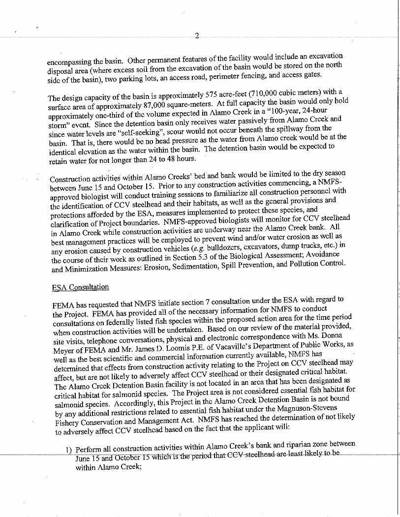


Federal Emergency Management AgencyDepartment of Homeland Security1111 Broadway, Suite 1200Oakland, California 94607
Biological Assessment for NMFS
Alamo Creek Detention BasinCity of VacavilleFEMA-1628-DR-CA & FEMA-1646-DR-CA, HMGP #1628-31-14January 2010


This document was prepared with the support of URS Group, Inc. 1333 Broadway, Suite 800 Oakland, CA 94612 Contract No. HSFEHQ-06-D-0162 Task Order HSFEHQ-07-J-0004 15299521.00200


Table of Contents
ACRONYMS AND ABBREVIATIONS .......................................................................................................... v
SECTION ONE INTRODUCTION .......................................................................................................... 1-1
1.1 Project Area.................................................................................................................. 1-1 1.2 Preliminary Engineering and Environmental Investigation ......................................... 1-2
1.2.1 Geoarchaeological Testing and Site Evaluation Program................................ 1-2 1.2.2 Future Geotechnical Investigations .................................................................. 1-7
1.3 Proposed Project........................................................................................................... 1-7 1.3.1 Construction of Alamo Creek Detention Basin................................................ 1-7 1.3.2 Operation and Maintenance of Alamo Creek Detention Basin...................... 1-12
1.4 Summary of Agency Consultation to Date ................................................................ 1-12
SECTION TWO VEGETATION COMMUNITIES AND HABITAT TYPES.............................................. 2-1
2.1 Alamo Creek ................................................................................................................ 2-1 2.2 Riparian Woodland ...................................................................................................... 2-1 2.3 Orchard......................................................................................................................... 2-2 2.4 Wild Oat Agriculture Field .......................................................................................... 2-2 2.5 Developed..................................................................................................................... 2-2
SECTION THREE LIKELIHOOD OF OCCURRENCE OF FEDERALLY LISTED SPECIES ................. 3-1
3.1 California Central Valley Steelhead, DPS ................................................................... 3-1 3.1.1 Critical Habitat ................................................................................................. 3-1 3.1.2 Previously Documented Occurrences .............................................................. 3-2 3.1.3 Potential Fish Passage Barriers ........................................................................ 3-2 3.1.4 Potential To Occur ........................................................................................... 3-3
SECTION FOUR POTENTIAL EFFECTS OF THE PRELIMINARY ENGINEERING AND ENVIRONMENTAL INVESTIGATION AND PROPOSED PROJECT ................................ 4-1
4.1 Geoarchaeological Testing and Site Evaluation Program (June 30 to July 2, 2009)............................................................................................................................. 4-1
4.2 Future Geoarchaeological Testing and Site Evaluations and Geotechnical Investigations ............................................................................................................... 4-1
4.3 Construction, Operation, and Maintenance of the Alamo Creek Detention Basin ...... 4-2 4.3.1 Direct Disturbance, Injury, or Mortality .......................................................... 4-2 4.3.2 Indirect Downstream Effects............................................................................ 4-4
SECTION FIVE AVOIDANCE AND MINIMIZATION MEASURES ........................................................ 5-1
5.1 Proposed Project Timing.............................................................................................. 5-1 5.2 In-Stream Work............................................................................................................ 5-1
i
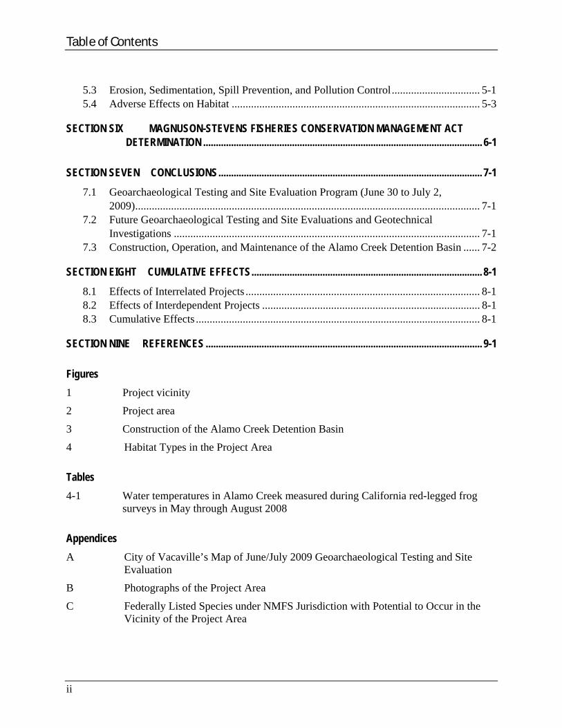
Table of Contents
ii
5.3 Erosion, Sedimentation, Spill Prevention, and Pollution Control................................ 5-1 5.4 Adverse Effects on Habitat .......................................................................................... 5-3
SECTION SIX MAGNUSON-STEVENS FISHERIES CONSERVATION MANAGEMENT ACT DETERMINATION .............................................................................................................. 6-1
SECTION SEVEN CONCLUSIONS........................................................................................................ 7-1
7.1 Geoarchaeological Testing and Site Evaluation Program (June 30 to July 2, 2009)............................................................................................................................. 7-1
7.2 Future Geoarchaeological Testing and Site Evaluations and Geotechnical Investigations ............................................................................................................... 7-1
7.3 Construction, Operation, and Maintenance of the Alamo Creek Detention Basin ...... 7-2
SECTION EIGHT CUMULATIVE EFFECTS........................................................................................... 8-1
8.1 Effects of Interrelated Projects ..................................................................................... 8-1 8.2 Effects of Interdependent Projects ............................................................................... 8-1 8.3 Cumulative Effects ....................................................................................................... 8-1
SECTION NINE REFERENCES ............................................................................................................. 9-1
Figures
1 Project vicinity
2 Project area
3 Construction of the Alamo Creek Detention Basin
4 Habitat Types in the Project Area
Tables
4-1 Water temperatures in Alamo Creek measured during California red-legged frog surveys in May through August 2008
Appendices
A City of Vacaville’s Map of June/July 2009 Geoarchaeological Testing and Site Evaluation
B Photographs of the Project Area
C Federally Listed Species under NMFS Jurisdiction with Potential to Occur in the Vicinity of the Project Area

Acronyms and Abbreviations
°F degrees Fahrenheit
ACDB Alamo Creek Detention Basin
BA Biological Assessment
BMP Best Management Practice
CalEMA California Emergency Management Agency
CCC Central California Coastal
CCV California Central Valley
CDFG California Department of Fish and Game
City City of Vacaville
CNDDB California Natural Diversity Database
CRLF California red-legged frog
CVSR Central Valley spring-run
DPS distinct population segment
DSOD California Department of Water Resources Division of Safety of Dams
EFH Essential Fish Habitat
ESA Endangered Species Act
ESU evolutionary significant unit
FDB Florence Detention Basin
FEMA Department of Homeland Security’s Federal Emergency Management Agency
FR Federal Register
ft/s foot (feet) per second
HMGP Hazard Mitigation Grant Program
MSFCMA Magnuson-Stevens Fisheries Conservation and Management Act
NAVD88 North American Vertical Datum of 1988
NLAA not likely to adversely affect
NMFS National Marine Fisheries Service
SRWR Sacramento River winter-run
URS URS Group, Inc.
U.S.C. United States Code
USFWS U.S. Fish and Wildlife Service
USGS U.S. Geological Survey
iii


Introduction
SECTION ONE INTRODUCTION
The Department of Homeland Security’s Federal Emergency Management Agency (FEMA) proposes to provide Federal financial assistance (Federal action) under the Hazard Mitigation Grant Program (HMGP) to the City of Vacaville (City) in Solano County, California, through the California Emergency Management Agency (CalEMA), to implement the Alamo Creek Detention Basin (ACDB) Project (proposed project). The detention basin, which would be constructed on approximately 77 acres of City-owned property, would reduce the potential for damage from flooding on Alamo Creek. Severe storms from December 17, 2005, to January 3, 2006, and March 29, 2006, to April 16, 2006, caused the creek to overrun its channel, resulting in widespread flooding of roads, farms, houses, and businesses adjacent to the creek and within the City limits (Presidentially declared Severe Storms, Flooding, Mudslides, and Landslides Disaster of 2005–2006, FEMA-1628-DR-CA and FEMA-1646-DR-CA).
Alamo Creek drains an area of approximately 10 square miles in the vicinity of the City of Vacaville and is one of approximately six major drainage channels that flow through the City. The channel of Alamo Creek has been determined to have insufficient capacity to contain a 10-year flood event, and the creek is known to overflow its banks within the City boundary during storm events. In recent years, heavy rainfall has caused the creek to overflow onto City streets, businesses, public property, and private property. Damages in the City from the 10-year flood event on Alamo Creek that occurred in December 2002 totaled approximately $3.4 million, and damages in the City from the 28-year flood event on Alamo Creek that occurred in December 2005 totaled approximately $26.5 million. The proposed project would reduce the potential for damage from flooding on Alamo Creek.
This Biological Assessment (BA) was conducted to evaluate the potential effects of the proposed project on species that are listed or proposed for listing under the Endangered Species Act of 1973 (ESA) (16 U.S.C. §§ 1531–1544 [2008]) and that are under the jurisdiction of the National Marine Fisheries Service (NMFS). The potential effects on federally listed species have been evaluated in accordance with Section 7 of the ESA (16 U.S.C. § 1536).
FEMA is consulting separately with the U.S. Fish and Wildlife Service (USFWS) regarding the potential adverse effects to species that are listed and proposed to be listed under the ESA and that are under USFWS jurisdiction.
1.1 PROJECT AREA
The project area is northwest of Vacaville, California, approximately 54 miles northeast of San Francisco and 34 miles southwest of Sacramento (Figure 1). The project area is northwest of the City (Figure 2) between Pleasants Valley Road (west) and Rogers Lane (east) and Vaca Valley Road (north). The southern boundary of the project area is along the northern bank of Alamo Creek. The project area consists of approximately 77 acres, which are owned by the City.
1-1

Introduction
The project area is defined as the limit of proposed construction activities associated with implementation of the proposed project (e.g., access and construction staging areas). The project area includes all areas that may be permanently or temporarily disturbed by the proposed project.
1.2 PRELIMINARY ENGINEERING AND ENVIRONMENTAL INVESTIGATION
The preliminary engineering and environmental investigation consists of a geoarchaeological testing and site evaluation program and geotechnical investigations, if necessary. A geoarchaeological testing and site evaluation program, in support of Section 106 of the National Historic Preservation Act of 1966 (16 U.S.C. 470f [2008]) compliance, was implemented between June 30 and July 2, 2009. Additional geoarchaeological testing and site evaluation may be necessary. Geotechnical investigations may be necessary for the City to complete its detailed project design and obtain approval for the proposed project from the California Department of Water Resources Division of Safety of Dams (DSOD).
1.2.1 Geoarchaeological Testing and Site Evaluation Program As a part of FEMA’s compliance with Section 106 of the National Historic Preservation Act for the proposed project, a geoarchaeological testing and site evaluation program was conducted by the City within the project area. Ground-disturbing activities associated with the geoarchaeological testing and site evaluation program were completed between June 30 and July 2, 2009, and involved the use of mechanical trenching techniques. Exploration trenches were excavated at 28 locations throughout the site (Appendix A). The excavation depth averaged approximately 12.5 feet below ground surface.
The geoarchaeological testing and site evaluation program was performed within the following constraints:
Ground-disturbing activities occurred during the dry season (June 15 through October 15), specifically between June 30 and July 2.
Ground-disturbing activities occurred 50 feet or more from the centerline of Alamo Creek except for two trenches (one was approximately 49 feet north of the centerline of Alamo Creek, and the other was approximately 25 feet north of the centerline of Alamo Creek).
All temporarily disturbed sites were returned to original conditions after completion of the ground-disturbing activities.
1-2

Project area
113
12
121
128
160
29
37
84
141
113
12
113
80
680
505
78080
L:\
Pro
ject
s\F
EM
A_
CA
_B
io_
HG
MP
_1
52
99
52
1\M
ap
s\P
roje
cts
\Fig
_0
1_
vic
inity
_m
ap
.mx
d -
6/2
5/2
00
9 @
10
:20
:25
AM
Figure 1Project vicinity
0 2 4 6
MILES
Base map source: USGS 1x2-degree topographic series,Santa Rosa and Sacramento quadrangles
Map area
Fresno
Sacramento
SanFrancisco
PACIFICOCEANFresno
Tulare
Mono
Tehama
Monterey
Plumas
ButteMendocino
Madera
Lake
Merced
Kings
Tuolumne
Yolo
Glenn
Sonoma
Colusa
Mariposa
TrinityLassen
Napa
Solano
Alpine
Alameda
Sierra
Stanislaus
Kern
SanBenito
SanJoaquin
SantaClara
Calaveras
Sutter
Marin
Amador
ContraCosta
SanMateo
Santa Cruz
Placer
El Dorado
NevadaYuba
FEMA-1628-DR-CA & FEMA-1646-DR-CA,HMGP #1628-31-14
City of VacavilleAlamo Creek Detention Basin
UR
S C
orp
- O
ak
lan
d,
CA
- B
.Ja
co
bs
en


Vine
Buck
Orch
ard
Alamo
West
Brow
n
Gates Canyon
Gibson Canyon
Monte Vista
Fruitvale
Deodara
Vaca Valley
Mason
Elder
Roge
rs
Fir
Brow
ns Va
lley
Markham
Foothill
Hemlock
Stins
on
Wrentham
Buck
town
Eldridge
Wykoff
Cern
on
Buckeye
Limeri
ck
Main
Grape
Kendal
Solar Hills
Rock
y Hill
Farrell
Lovers
Davis
Peach Tree
Crestview
Plum
Hespeller
Dobbins
Luzena
Granada
Callen
Azalea
Acacia
Cottonwood
Linwood
Magnolia
Serenity Hills
Ballin
dine
Walnut
Citrus
Rustic
Tippe
rary
Mercha
nt
Sunny Hills
Park
er
Park
Camellia
Dennis
Woodcrest
Juniper
Mendes
Ches
tnut
Elm
Glen Eagle
Ramb let on
Novato
Salinas
Mcclellan
Timbe
r
Ramp
Boyd
Elmira
Bald Eag le
Arlene
Wesley
Shady Glen
Depot
Gable
Bear
d
Kent
ucky
Dubli
n
Pintail
Marc
o
Marbella
Florence
Evergreen
Silve
r Eag
le
Clarescastle
Lomita
Gonzales
Eliza
beth
Cherry
School
Waterford
Dusty
Manzanita
Fern
Shannon
Stevenson
Catherine
Clift
on
Hazel
Sund
ance
Trianon
Encin
osa
Alta Mira
Sene
ca
Cheye
nne
Edge
wood
Hills
view
Ironwood
Highland
Sungate
Ridgewood
San Leon
Anita
Bantr
y
Aubu
rn
Willia
ms
AshAr
bor
Kappel Hill
Cort e Vista
Spring
Ceda
r
Palm
Meadows
Lara
mie
Su n cre st
Bluewater
Auro
ra
Chan
dler
Popla
r
Valencia
Blue
Ridg
e
Cordoba
Hidden Glen
E dgewater
Sunridge
Westwood
Solano
Grani te
V i s ta V
i ew
Wood
side
Kildare
Briarwood
Alpin
e
Morales
Philip
Holly
Longf ord
Rolling Oak
Bush Valle
y
Peab
ody
Suisun
Mcknight
Pinecrest
Hillto
p
Virgin
ia
Madr
one
Iroquois
Sunrise
O ak Hill
Woburn
El Cerrito
Mayo
Parkridge
Monte Verde
C
ir c le
Donegal
Ramo
na
Mojave
Brookside
AegeanWerner
Forb es
Zarag
oza
Lone Oak
Tracy
Wethersfield
Scoggins
Jepson
Hidden Valley
Viewmon t
Wellington
Bennett H ill
Santa Fe
Kiow
a
Quate
Milford
Palisades
Kilgarvan
Grey Wolf
Pepp erell
Orchard Canyon Grafton
Coventry
Quietwood
Carmel
Alturas Alica
nte
Wexford
Blossom Oak
Alta
Vista
Home
wood
Olivera
Castl
ewoo
d
Kirb
yson
Bernard
Hills
ide
Sycamore
Teal
Havenwood
Nile
Petal
Fox Oak
Boulderidge
Bres
ee
Ardmore
Rosemont
Landon
Devon
Chinook
Tuliamore
Harwinton
Chelmsford
Tranq
uility
MulberryRollingwood
Grey
hawk
Swindon
Edmo
ndale
Amberwood
Cochise Yuma
Dellw
ood
Lojas
Willowwood
Grove
San J
uan
Nighthawk
Vine
Main
Ramp
Eldridge
Ramp
Shady Glen
Farrell
Shady Glen
Stevenson
Briarwood
Beard
Stinson
Vaca Valley
Monte VistaVine
Ramp
Ramp
Depot
Arlen
e
Vine
Fruitvale Ave
Hawthorn
Pleasants Valley
Project area
VACAVILLE
VA
CA
M
OU
NT
AI
NS
80
Ulatis Creek
Alamo Creek
Encinosa Creek
L:\
Pro
ject
s\F
EM
A_
CA
_B
io_
HG
MP
_1
52
99
52
1\M
ap
s\P
roje
cts
\Fig
_0
2_
pro
jec
t_lo
catio
n_
11_
17
.mxd
- 6
/29
/20
09
@ 2
:22
:52
PM
Figure 2Project area
FEMA-1628-DR-CA & FEMA-1646-DR-CA,HMGP #1628-31-14
City of VacavilleAlamo Creek Detention Basin
UR
S C
orp
- O
ak
lan
d,
CA
- B
.Ja
co
bs
en
Imagery source: USDA National Agriculture Imagery Program,Solano County mosaic, 2005
0 1,000 2,000
Feet


Introduction
Any additional geoarchaeological testing and site evaluations would implement the following constraints:
Ground-disturbing activities occur during the dry season, specifically between June 15 and October 15.
Ground-disturbing activities occur 50 feet or more from the centerline of Alamo Creek.
All temporarily disturbed sites are returned to original conditions after completion of the ground-disturbing activities.
If the City requires modifications to the above constraints, the City would notify FEMA prior to conducting the activity and FEMA would determine if consultation with NMFS would be necessary.
1.2.2 Future Geotechnical Investigations As a part of the process of designing the proposed project and obtaining approval from the DSOD, the City may need to conduct geotechnical investigations, which would involve ground-disturbing activities within the project area before beginning construction. Geotechnical investigations could include activities such as the preparation of test borings, test pits, and cone penetrations within the project area. All geotechnical investigations would be conducted with the following constraints:
Ground-disturbing activities occur during the dry season, specifically between June 15 and October 15.
Ground-disturbing activities occur 50 feet or more from the centerline of Alamo Creek.
All temporarily disturbed sites are returned to original conditions after completion of the geotechnical investigations.
If the City requires modifications to the above constraints, the City would notify FEMA prior to conducting the activity and FEMA would determine if consultation with NMFS would be necessary.
1.3 PROPOSED PROJECT
1.3.1 Construction of Alamo Creek Detention Basin The proposed project would be designed and constructed to meet DSOD requirements. The geological conditions and characterization of the project area would be ongoing until the proposed project is under construction. Because DSOD does not complete the approval of a project design until construction is underway, the project design is subject to change per DSOD requirements after construction has been initiated. Most of the elements of the proposed project described below are therefore subject to change.
1-7

Introduction
The proposed project would be designed to reduce the existing flood hazard from Alamo Creek within the City boundaries during flood events. The inlet structure would be designed to passively allow flowing water in Alamo Creek to flow into the detention basin when water in the creek is less than the 10-year flood event elevation. The proposed project would be designed to store up to 575 acre-feet of water, with a surface area of approximately 104,000 square yards. At this capacity, the detention basin would provide less than a third of the storage required to hold the discharge from the 100-year, 24-hour storm event. The detention basin would be designed to retain water for 24 to 48 hours. Retained water would be passively released back into Alamo Creek through an outfall structure. The outfall structure would limit, but not stop, the gravity flow of floodwater back into Alamo Creek. Water in the detention basin would flow over an engineered spillway in the southern berm during flood events that exceed the capacity of the detention basin.
The detention basin would be excavated and constructed with an earthen bottom, engineered earthen berms, an emergency spillway, a 300-foot-wide articulated concrete block inlet structure, a 42-inch-diameter reinforced-concrete pipe outlet, and a maintenance road. An excavation disposal area, two parking lots, an access road, perimeter fencing, and access gates would also be constructed adjacent to the detention basin on the 77-acre City-owned parcel as permanent features of the facility (Figure 3).
Construction of the proposed project would begin with mass grading of the project area. The grading would include the removal of trees and other vegetation and the demolition of several structures along the eastern side of the project area. Trees and vegetation in the vicinity of the intake and outfall structures would be permanently removed, but trees and other vegetation in the riparian zone would not to be removed and would be primarily protected.
The footprints for the detention basin, intake structure, and outfall structure and the foundation area for the berms would be excavated. The maximum depth of excavation would be approximately 17 feet below ground surface. The basin bottom would consist of native soil and would have a lowest depth of 227 feet above the North American Vertical Datum of 1988 (NAVD88). The berm closest to Alamo Creek would be constructed outside the 100-year floodplain. The berms would have a maximum crest elevation of 255 feet above NAVD88 and an approximate crest width of 20 feet. An approximately 12-foot-wide maintenance road would be constructed atop the crest. An emergency spillway would be constructed across the crest on
1-8
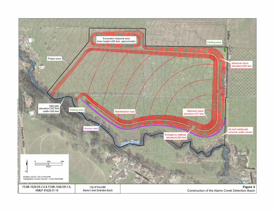
Parking area
Access road
Parking area
Alamo Creek
Inlet weirelevation=242 feet
width=300 feet
Excavation disposal area(max height=265 feet, approximate)
Maximum bermelevation=255 feet
42-inch reinforcedconcrete outlet culvert
Emergency spillwayelevation=250 feet
Minimum basinelevation=227 feet
Project area
Maintenance road
Rog
ers
Ple
asants V
alley
Hidden Valley
Fruitvale
Dunsm
uir
L:\
Pro
ject
s\F
EM
A_
CA
_B
io_
HG
MP
_1
52
99
52
1\M
ap
s\P
roje
cts
\Fig
_0
4_
Co
nst
ruct
ion
.mx
d -
8/2
7/2
00
9 @
7:5
6:3
7 A
M
Figure 3Construction of the Alamo Creek Detention Basin
City of VacavilleAlamo Creek Detention Basin
FEMA-1628-DR-CA & FEMA-1646-DR-CA,HMGP #1628-31-14
UR
S C
orp
- O
ak
lan
d,
CA
- B
.Ja
co
bs
en
0 200 400
FEET
Imagery source: City of VacavilleTopographic contour interval = 2 feet (NAVD88)

Introduction
the eastern side of the southern berm. The emergency spillway would have a reinforced-concrete bottom and would be 50 feet wide at its bottom, with an invert elevation of 250 feet above NAVD88. The berms would be constructed on an engineered fill foundation that would be built on undisturbed native soil. Soil excavated for the basin, intake structure, and outlet structure would be used to construct the berms. The berms would have a maximum side slope of 3 horizontal to 1 vertical (3:1).
The intake structure would consist of an inlet weir lined with articulated concrete block placed on undisturbed native soil. The block would be designed based on the flow characteristics of the inlet and the block manufacturer’s recommendations. Riprap could be placed at the junction between the intake structure and Alamo Creek to prevent scour. Because the intake structure would function passively, it would not extend into the natural stream channel. The inlet weir would have an invert elevation of 242 feet above NAVD88 and a bottom width of 300 feet.
The outfall structure would consist of a 42-inch-diameter reinforced-concrete culvert constructed on a reinforced-concrete bed. This structure would be designed to meter the detained water into Alamo Creek. Water would be conveyed through the outfall structure by gravity. The outfall structure would be constructed using open channel trenching methods. The creek bank would be lined with half–ton rock riprap at the terminus of the outfall structure to prevent scour, and the terminus of the culvert could include a flap gate.
To minimize off-site disposal and truck trips, some excess excavated soil would be stored at an onsite disposal area. The site would have a height of approximately 265 feet above NAVD88, would be constructed on undisturbed native soil, and would have a maximum slope of 3:1. Any additional excess soil from excavation would be trucked to other locations in accordance with local, State, and Federal requirements.
On completion of the mass grading and the construction of the berms, disposal site, and intake and outfall structures, the project area would be finish-graded. The finish-grading would include the completion of the maintenance road along the berms; the permanent parking areas; and the access road that would be used for maintenance-related access to the intake structure, one of the parking areas, the southern berm, and the maintenance road along the southern berm. Temporarily disturbed soils within the project area would be hydroseeded, a fence would be installed in upland areas around the perimeter of the property boundary, and access gates would be installed.
The area of temporary and permanent disturbance would be limited to the project area. As stated above, with the exception of areas where the outfall and intake structures would be installed, the riparian zone would not be disturbed. All equipment would be staged in the project area outside the riparian and stream zones. Rogers Lane would be used to access the project area. The proposed project does not include improvements to Rogers Lane.
The City would implement avoidance and minimization measures related to project timing, in-stream work activities, habitat, and erosion, sedimentation, spill prevention, and pollution
1-11

Introduction
control, as described in Section 5. The City would also implement all standard and necessary Best Management Practices (BMPs) to protect water quality, wetlands, waters of the United States, and the Alamo Creek streambed through its compliance process with Sections 401, 402, and 404 of the Clean Water Act of 1972 (33 U.S.C. §§ 1341, 1342, 1344 [2008]) and Section 1600 et seq. of the California Fish and Game Code. Any construction-related BMPs required under local regulations or by local regulatory agencies (e.g., BMPs to reduce construction-related air quality effects, noise effects, or traffic control) would be implemented, as applicable.
The proposed project would take approximately 450 working days to construct. Construction activities would require a maximum of 20 workers onsite at any one time. An estimate of the maximum number of equipment pieces that could be used at the project area at any one time is as follows:
Water trucks, rubber tired: 3
Excavators, tracked: 3
Backhoes, rubber tired: 2
Bulldozers, tracked: 4
Scrapers, rubber tired: 5
Compactors, sheep’s foot: 4
Bottom dump trucks, rubber tired: 10
Pickup trucks, rubber tired: 10
1.3.2 Operation and Maintenance of Alamo Creek Detention Basin Operation and maintenance of the ACDB would be minimal. The intake and outfall structures would operate passively and would not require personnel. The basin is anticipated to operate less than once every 10 years (or less than a 10 percent chance of operation every rainy season). The bottom of the basin may be used for agriculture purposes. Debris removal and cleanup would occur after the winter and spring rainy season. Some debris removal may be needed during the winter but is anticipated to be needed infrequently. Accumulated silt would be removed bi-annually using a backhoe or excavator. Weed abatement would occur throughout the summer. Weed abatement through mowing and/or use of an herbicide (Aquamaster) would be performed two to three times in the summer to restrict the accumulation of fire fuel and maintain water flow in the basin. If the bottom of the basin is used for agricultural purposes, weed abatement activities could occur less frequently.
1.4 SUMMARY OF AGENCY CONSULTATION TO DATE
FEMA has initiated informal consultation with NMFS. Additionally, on behalf of FEMA, URS Group, Inc. (URS), biologists Lorena Solórzano-Vincent and Melissa Newman have engaged in
1-12

Introduction
informal communications with Madelyn Martinez and Rick Bush from NMFS. A summary of the communications and consultations with this agency is provided below.
August 4, 2008 – Ms. Solórzano-Vincent and Ms. Newman of URS initiated conversations with Ms. Martinez of NMFS regarding the proposed project.
September 18, 2008 – Ms. Solórzano-Vincent and Ms. Newman spoke with Ms. Martinez by telephone regarding potential species under NMFS jurisdiction that have the potential to occur in the project area. Ms. Martinez discussed the project design information that would be required for her to analyze potential effects and potential conservation measures that could be implemented.
January 20, 2009 – Ms. Solórzano-Vincent and Ms. Newman met with Mr. Bush, the new NMFS liaison to FEMA, and provided a general overview of the proposed project and a request for confirmation of the species and designated critical habitat under NMFS jurisdiction within the project area.
January 22, 2009 – URS transmitted figures of the location of the proposed project by email to Mr. Bush at NMFS to clarify the location of the project area.
January 26, 2009 – NMFS transmitted an email to URS, which was forwarded to FEMA, which described that NMFS required that a formal letter be sent from FEMA to NMFS requesting the information discussed on January 20, 2009.
February 5, 2009 – Ms. Solórzano-Vincent and Ms. Newman of URS met with Mr. Bush and Ms. Martinez of NMFS and James Loomis, Deborah Faaborg, and Tawnia Skow from the City at the project area to conduct a site visit related to the geoarchaeological testing and site evaluation. During the site visit, Mr. Bush and Ms. Martinez stated that NMFS could concur with a “not likely to adversely affect” (NLAA) determination for the geoarchaeological testing and site evaluation without a dry season (June 15 to October 15) time restriction if the following three conditions were met:
– All work is done when the creek is dry.
– No work is done within a minimum 50-foot buffer of the creek.
– No rain is forecast for 1 week before and 1 week after the geoarchaeological testing and site evaluation.
Ms. Solórzano-Vincent and Ms. Newman explained that several small test holes may need to be dug by hand within 50 feet of the creek as part of the geoarchaeological testing and site evaluation. Mr. Bush and Ms. Martinez stated they would need more information about the location of and the activities associated with the test holes before NMFS could concur with an NLAA for the geoarchaeological testing and site evaluation.
February 19, 2009 – Ms. Solórzano-Vincent and Ms. Newman discussed the logistical issues with the NMFS conditions for the geoarchaeological testing and site evaluation
1-13

Introduction
1-14
(listed above) with Ms. Martinez of NMFS in a telephone conversation. The logistical issues were as follows:
– Conducting the geoarchaeological testing and site evaluation when the creek is dry would be difficult or impossible because the western end of the creek may be wet year-round because of the high groundwater table.
– Due to the potential duration of the proposed project (up to 10 days), obtaining an accurate weather forecast of 24 days (7 days before, 10 days of work, 7 days after) in advance of the geoarchaeological testing and site evaluation is unrealistic.
Ms. Martinez stated that NMFS could agree to an NLAA for the geoarchaeological testing and site evaluation without a time restriction if the following revised conditions were met:
– No Shovel Test Units (i.e., 50-centimeter [cm] × 50-cm hand excavations) are conducted within a 50-foot buffer of the creek.
– No trenches and excavation units (i.e., 100-cm × 100-cm hand excavations and 50-foot-long × 3-foot-wide trenches) are conducted within a 100-foot buffer of the creek.
– No forecast of rain the week before the activities associated with the proposed project are scheduled, no forecast of rain for the week of the activities, and no rain during the activities.
– Installation of silt fences along the creek banks if rain is forecast for immediately after the activities are scheduled to be completed.
– The return of all temporarily disturbed sites to original conditions after completion of the proposed project.
March 18, 2009 – FEMA transmitted a letter to NMFS initiating informal consultation and requesting guidance on the anadromous fish species and designated critical habitat that would need to be addressed in the NMFS BA for the proposed project. FEMA has not received a response from NMFS regarding this transmittal.
April 14, 2009 – FEMA forwarded information to NMFS provided by the City to support the City’s claims that federally protected species under the jurisdiction of NMFS do not occur and do not have the potential to occur in Alamo Creek. FEMA has not received a response from NMFS regarding this transmittal.
September 30, 3009 – A new contact at NMFS was identified, Jeremy Redding.
Vegetation Communities and Habitat Types
SECTION TWO VEGETATION COMMUNITIES AND HABITAT TYPES
The project area is in Vaca Valley, which is bounded by Vaca Mountain to the west and the English Hills to the east. The English Hills represent the transition from the inner North Coast range habitats into the Sacramento Valley habitats. Elevations in the project area range between 220 and 258 feet above mean sea level. Five habitats were observed in the project area. The habitat types are shown on Figure 4 and described below. Photographs of the project area are provided in Appendix B.
2.1 ALAMO CREEK
Alamo Creek is an intermittent drainage that flows west to east through the southern portion of the project area. The creek flows from the Vaca Mountains, approximately 1.5 miles (straight-line distance) northwest of the project area, into Ulatis Creek, approximately 11 miles (straight-line distance) southeast of the project area. Ulatis Creek drains into Cache Slough of the Sacramento-San Joaquin Delta.
Within the project area, Alamo Creek varies in width, depth, composition, and flow rate, and exhibits sinuosity. The creek itself is a slow-to-medium moving stream with a mostly sandy substrate and some areas of silt and gravel. The wetted width of the stream varies from 2 to 15 feet and the stream depth varies from 2 to 6 feet. Intermittent pools and scattered logs and woody debris are located along the stream length. Emergent and overhanging vegetation are present within the stream and along the creek bank. Vegetation along the creek bank is characterized by riparian woodland (described below) dominated by valley oak and red willow. The majority of the creek bank is incised to deeply incised.
During site visits in May 2008, the majority of Alamo Creek in the project area was wet and flowing gently, but by June 2008 much of the stream had dried to shallow, intermittent pools. By July 2008, approximately 65 percent of the downstream portion of the section was dry. A small portion of the upstream end of the creek channel in the project area is likely wet year-round and was observed as such during the sites visits conducted in 2008. This may be a result of a high ground water table in this area.
2.2 RIPARIAN WOODLAND
The riparian corridor extends approximately 35 to 50 feet on either side of Alamo Creek (approximately 5 acres of the project area) (Figure 4). The canopy is dense and dominated by valley oaks. Other prominent species in the canopy include California walnut (Juglans californica), red willow, interior live oak (Quercus wislizenii), and big leaf maple (Acer macrophyllum). The understory is dominated by Himalayan blackberry (Rubus discolor), poison oak (Toxicodendron diversilobum), arroyo willow (Salix lasiolepis), and blue elderberry (Sambucus mexicana). The fringes of the riparian area, where more light penetrates, have a
2-1

Vegetation Communities and Habitat Types
diversity of species including Indian hemp (Apocynum cannibinum), smilo grass (Piptamtherum millaceum), and mugwort (Artemesia douglasiana).
2.3 ORCHARD
The majority of the project area is characterized as an abandoned orchard (approximately 45 acres of the project area) (Figure 4). The orchard consists of plum trees (Prunus cerasifera and Prunus domestica) with several scattered apricot trees (Prunus armeniaca). The northern border is lined with grafted walnut trees (Juglans regia on J. californica stock). The understory is highly disturbed and dominated by nonnative herbs and grasses including wild oat, Mediterranean barley (Hordeum marnium), Italian ryegrass (Lolium multiflorum), ripgut broom (Bromus diandrus), burclover (Medicago polymorpha), prickly lettuce (Lactuca serriola), and bristly ox-tongue (Picris echiodes). The northern orchard (north of the access road dividing the site) is densely covered with field mustard (Brassica rapa), in addition to the weedy grasses and herbs listed above.
2.4 WILD OAT AGRICULTURE FIELD
The northwestern corner of the property consists of an actively used agricultural field (approximately 23 acres of the project area) (Figure 4). The field has been disked and planted with wild oat. Bindweed (Convolvulus arvenus) was beneath the wild oat along with scattered black mustard (Brassica nigra) and wild radish (Raphanus sativus).
2.5 DEVELOPED
Approximately 3 acres of the project area are developed habitat (Figure 4). A homestead at the northeastern part of the project area contains houses, trailers, and cars and covers approximately 1 acre of the project area. Adjacent to the homestead is ornamental landscaping, including lawns and fruit trees. The farm roads bisecting the project area, a junk pile, and a cleared area contain bare ground and weedy, nonnative grasses (wild oat, Mediterranean barley, Italian ryegrass, and ripgut broom).
2-2

Farm road
Rog
ers
La
ne
Ple
asants V
alley R
oad Hidden Valley
Project area
Alamo Creek
L:\
Pro
ject
s\F
EM
A_
CA
_B
io_
HG
MP
_1
52
99
52
1\M
ap
s\P
roje
cts
\Fig
_0
7_
ha
bit
at_
typ
es.
mxd
- 6
/25
/20
09
@ 1
0:1
1:5
1 A
M
Figure 4Habitat types in the project area
UR
S C
orp
- O
ak
lan
d,
CA
- B
.Ja
co
bs
en
FEMA-1628-DR-CA & FEMA-1646-DR-CA,HMGP #1628-31-14
City of VacavilleAlamo Creek Detention Basin
Imagery source: City of Vacaville
0 200 400
FEET
Project area
Habitat typeWild oat agriculture field
Developed
Orchard
Riparian woodland

Likelihood of Occurrence of Federally Listed Species
SECTION THREE LIKELIHOOD OF OCCURRENCE OF FEDERALLY LISTED SPECIES
Species identified in the databases searches (see cover letter for description of study methods) as having potential to occur in the vicinity of the project area, but not within the project area itself that are under the jurisdiction of NMFS under the ESA are listed in Appendix C. As a result of the field and background review, FEMA determined that the project area may provide habitats suitable to support one species regulated by NMFS under the ESA:
California Central Valley steelhead (CCV steelhead) (Oncorhynchus mykiss), distinct population segment (DPS) (Threatened)
3.1 CALIFORNIA CENTRAL VALLEY STEELHEAD, DPS
Along the Pacific Coast, the steelhead has been divided into DPSs based on genetic similarities and watershed boundaries. The CCV steelhead DPS was listed as threatened on March 19, 1998 (63 FR 13347), and the status was reaffirmed on January 5, 2006 (71 FR 834). The CCV steelhead DPS includes all naturally spawned anadromous steelhead populations below natural and manmade impassable barriers in the Sacramento and San Joaquin rivers and their tributaries, excluding steelhead from San Francisco and San Pablo bays and their tributaries, as well as two artificial propagation programs: the Coleman National Fish Hatchery, and Feather River Hatchery steelhead hatchery programs (71 FR 834; NMFS 2009a, 2009b).
The steelhead migrates as a juvenile from freshwater to the ocean, then returns to spawn in freshwater (Fukushima and Lesh 1998; NMFS 2006a). This species requires cool, clean, well-oxygenated water and appropriate gravel for spawning (Moyle 2002). The steelhead prefers habitats with cool temperatures and is found where daytime temperatures range from nearly 32 °F in winter to 81°F in summer and water temperatures range from 50 to 64°F (Moyle 2002). After steelhead eggs hatch, fry rear in edgewater habitats with low velocities and gradually move into pools and riffles as they grow larger (Barnhart 1986; Bjornn and Reiser 1991; NMFS 2006a). Juvenile steelhead may remain in the creeks year-round; therefore, adequate flows, suitable water temperatures, cover, and an abundant food supply are necessary throughout the year to sustain steelhead populations. (Busby et al. 1996; Barnhart 1986; Bjornn and Reiser 1991; NMFS 2006a).
3.1.1 Critical Habitat Final critical habitat was designated for the CCV steelhead DPS on September 2, 2005 (70 FR 52488). Critical habitat information for the CCV steelhead DPS is organized by California Interagency Watershed Mapping Committee (CalWater) hydrologic units. Alamo Creek is located in the Valley Putah-Cache Hydrologic Unit and is designated as an “occupied but excluded streams/area (70 FR 52488)”. The portion of Alamo Creek that is in the project area is not part of the critical habitat designated for the CCV steelhead DPS. Critical habitat is present in
3-1

Likelihood of Occurrence of Federally Listed Species
the lower portion of Alamo Creek (downstream of the project area) near the confluence with Ulatis Creek and Cache Slough.
3.1.2 Previously Documented Occurrences The project area and Alamo Creek are in the geographic range of the CCV steelhead DPS (NMFS 2009a, 2009b). Although there are no recent or historical CNDDB records of this species within the nine USGS 7.5-minute quadrangles surrounding and including the project area (CDFG 2009), steelhead presence has been documented, at least periodically, within Alamo Creek. This is supported by the following sources:
There is an Aquatic Species Observation Database record within the California Cooperative Anadromous Fish and Habitat Data Program (CalFish) database indicating that steelhead were present within Alamo Creek upstream of the project area during the 2005 spawning season. This information is based on a single observation of two steelhead individuals approximately 2.5 miles upstream of the project area in the Gates Canyon section of Alamo Creek (CalFish 2009). In order for a migrating steelhead to reach this location within the creek, it would have had to move through the project area.
Madelyn Martinez and Rick Bush, both of NMFS, confirmed by phone and personal conversations that the CCV steelhead DPS may be found in Alamo Creek within the project area (M. Martinez, NMFS, and R. Bush, NMFS, oral communication, 2008).
According to a February 17, 2006, memorandum issued by NMFS Regional Administrator Rodney McInnis regarding Scientific Research Permit No. 1180-15422SQE2003SA8820, no salmonids were captured during fish monitoring studies conducted by Thomas R. Payne and Associates in 2001 and 2002 within the lower portions of Ulatis Creek and its tributaries (including the lower portions of Alamo Creek [project area not included]) (NMFS 2006b). The surveys were conducted as part of the Ulatis Flood Control Project. In addition to the surveys, the memorandum states that a City of Vacaville staff member reported a prior observation of four to six steelhead in a portion of Ulatis Creek within downtown Vacaville in 1997, a high flow year. While Alamo Creek drains into Ulatis farther downstream from the City of Vacaville than where this observation occurred, this occurrence demonstrates that steelhead can enter Ulatis Creek, which Alamo Creek is a tributary to, and that steelhead can exist in stressed urban conditions in channelized areas where habitat may be of lower quality.
3.1.3 Potential Fish Passage Barriers There are no documented fish passage barriers in the project area or immediately downstream of the project area (CalFish 2009). However, there are potential fish passage barriers and numerous unscreened diversions a considerable distance downstream from the project area along Alamo and Ulatis creeks that may limit or restrict access to and along Alamo Creek, the project area, and potential habitat located upstream from the project area (CalFish 2009).
3-2

Likelihood of Occurrence of Federally Listed Species
One of the potential barriers downstream of the project area consists of four iron flap gates at the downstream confluence of Old Alamo Creek (natural stream channel) and New Alamo Creek (human-made channel), approximately 9 miles (straight-line distance) southwest of the project area, which may limit or prevent migration of salmonids into Old Alamo Creek (Tetra Tech, Inc. 2004). Old Alamo Creek and New Alamo Creek both occur along Alamo Creek and run parallel to each other (downstream of the project area). Old Alamo Creek likely contains more suitable habitat conditions for steelhead migration and possibly rearing. After the Tetra Tech, Inc., report was published in January 2004, there was an observation of steelhead in 2005 in a section of Alamo Creek upstream of Old and New Alamo Creeks and the project area (see Section 3.1.2). Therefore, steelhead are at least sometimes able to access the upper watershed of Alamo Creek, either via Old Alamo Creek or New Alamo Creek. According to the Tetra Tech report, NMFS stated that there has been at least one undocumented report of steelhead trout in New Alamo Creek (Tetra Tech Inc., 2004).
3.1.4 Potential To Occur The aquatic habitat in the project area does not appear to provide the physical or biological characteristics required for spawning due to the lack of suitable spawning gravels. Female steelheads spawn in gravel substrate, using gravel about 0.25 to 4.0 inches in diameter (Bjornn and Reiser 1991). Spawning and incubation gravels should contain less than 5 percent sand and silt to ensure high permeability and oxygen content (Bovee 1978; CDFG 1996). Alamo Creek substrate in the project area is primarily sand.
The aquatic habitat within the project area could be used by juvenile CCV steelhead DPS for juvenile rearing and dispersal and by adult CCV steelhead DPS for migration. During the 2008 URS surveys, several ponded areas were observed with undercut banks, downed logs, and tree roots that could provide suitable holding areas for migrating adults and summer refuges for juveniles and fry if temperatures and dissolved oxygen content are suitable. The dense riparian woodland corridor in the project area also enhances habitat for migrating and rearing steelhead potentially present within Alamo Creek by providing shade and cooler temperatures in the creek channel.
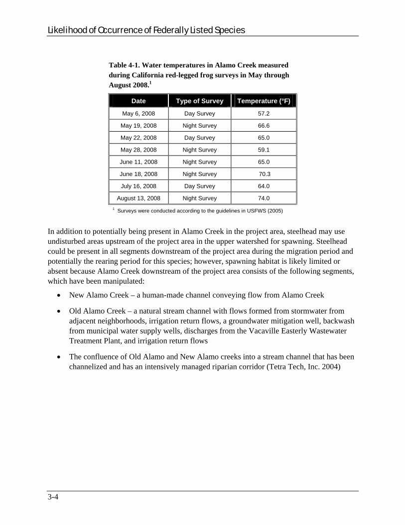
Water temperatures measured in pools in Alamo Creek in the project area during the 2008 protocol-level CRLF surveys for the proposed project (FEMA 2009a) were potentially low enough to support rearing steelhead (57.2 to 74.0°F; see Table 4-1), although the temperatures in the creek were at the higher end of the range for what juvenile steelheads can tolerate. Rearing steelhead juveniles prefer water temperatures of 45 to 58°F (Barnhart 1986; Bjornn and Reiser 1991; NMFS 2006a). The upper lethal limit is generally considered to be 75°F although they can survive in water up to 80°F with saturated dissolved oxygen conditions and a plentiful food supply. Juvenile steelhead would be more likely to use pools in Alamo Creek in the project area during wetter years when temperature and dissolved oxygen conditions would be more favorable.
3-3
Likelihood of Occurrence of Federally Listed Species
3-4
Table 4-1. Water temperatures in Alamo Creek measured during California red-legged frog surveys in May through August 2008.1
Date Type of Survey Temperature (°F)
May 6, 2008 Day Survey 57.2
May 19, 2008 Night Survey 66.6
May 22, 2008 Day Survey 65.0
May 28, 2008 Night Survey 59.1
June 11, 2008 Night Survey 65.0
June 18, 2008 Night Survey 70.3
July 16, 2008 Day Survey 64.0
August 13, 2008 Night Survey 74.0
1 Surveys were conducted according to the guidelines in USFWS (2005)
In addition to potentially being present in Alamo Creek in the project area, steelhead may use undisturbed areas upstream of the project area in the upper watershed for spawning. Steelhead could be present in all segments downstream of the project area during the migration period and potentially the rearing period for this species; however, spawning habitat is likely limited or absent because Alamo Creek downstream of the project area consists of the following segments, which have been manipulated:
New Alamo Creek – a human-made channel conveying flow from Alamo Creek
Old Alamo Creek – a natural stream channel with flows formed from stormwater from adjacent neighborhoods, irrigation return flows, a groundwater mitigation well, backwash from municipal water supply wells, discharges from the Vacaville Easterly Wastewater Treatment Plant, and irrigation return flows
The confluence of Old Alamo and New Alamo creeks into a stream channel that has been channelized and has an intensively managed riparian corridor (Tetra Tech, Inc. 2004)

Potential Effects of the Preliminary Engineering and Environmental Investigation and Proposed Project
SECTION FOUR POTENTIAL EFFECTS OF THE PRELIMINARY ENGINEERING AND ENVIRONMENTAL INVESTIGATION AND PROPOSED PROJECT
4.1 GEOARCHAEOLOGICAL TESTING AND SITE EVALUATION PROGRAM (JUNE 30 TO JULY 2, 2009)
Between June 30 and July 2, 2009, the City conducted geoarchaeological testing and a site evaluation in the project area. Ground-disturbing activities occurred during the dry season, between June 15 and October 15, and occurred 50 feet or more from the centerline of Alamo Creek except for two trenches (one was approximately 49 feet north of the centerline of Alamo Creek, and the other was approximately 25 feet north of the centerline of Alamo Creek) (Appendix A).
Although two trenches were excavated within the 50-foot buffer, the June/July 2009 geoarchaeological testing and site evaluation conducted by the City had no effect on species under NMFS jurisdiction because:
The activities were conducted during the dry season (June 15 to October 15).
The topography of the terrain is flat so there was no potential for erosion into the creek to occur.
The activities had a very small footprint of ground disturbance.
The area of Alamo Creek near Trenches 19 and 20 likely did not have ponded or flowing water in the creek bed at the time these activities where conducted.
All temporarily disturbed sites were returned to original conditions after completion of the ground-disturbing activities.
4.2 FUTURE GEOARCHAEOLOGICAL TESTING AND SITE EVALUATIONS AND GEOTECHNICAL INVESTIGATIONS
Potential geoarchaeological testing and site evaluations and geotechnical investigations conducted by the City are expected to have no adverse effects to species under NMFS jurisdiction as long as they are conducted within the following constraints:
Ground-disturbing activities occur during the dry season, specifically between June 15 and October 15.
Ground-disturbing activities occur 50 feet or more from the centerline of Alamo Creek.
All temporarily disturbed sites are returned to original conditions after completion of the ground-disturbing activities.
4-1
Potential Adverse Effects of the Preliminary Engineering and Environmental Investigation and Proposed Project
4.3 CONSTRUCTION, OPERATION, AND MAINTENANCE OF THE ALAMO CREEK DETENTION BASIN
4.3.1 Direct Disturbance, Injury, or Mortality The proposed project could result in disturbance, injury, and/or mortality of migrating or rearing steelhead during construction, operation, and/or maintenance of the proposed project.
Construction of the Alamo Creek Detention Basin
At the locations of the proposed inlet and outlet structures, a potential exists for rearing or dispersing juveniles or migrating adult steelhead to be killed, injured, or temporarily displaced if materials are placed into the creek at or below the ordinary high water mark.
If the creek were dry in the project area during the proposed construction activities, no adverse effects to steelhead would be anticipated.
Operation and Maintenance Activities
During periods of high flows, steelhead have the potential to become stranded in the basin for a short period of time. The proposed project would be designed to retain water for 24 to 48 hours; the retained water would be passively released back into Alamo Creek through an outfall structure. The outfall structure would limit, but not stop, the gravity flow of floodwater back into Alamo Creek. Because the outlet appears to be at the lowest point of the basin (Figure 3) where all water should eventually drain to, steelhead should move to the lowest point also, which would allow them to exit back into the creek through the outlet. It is possible that some steelhead could become trapped in small isolated pools in the basin or at the low point of the basin or in the culvert, depending on how much water originally entered the basin and how quickly it flowed out of the basin back into the creek through the culvert.
4.3.1.1 Water Quality: Erosion, Sedimentation, and Turbidity Migrating adult and rearing and migrating juvenile steelhead could be affected by potential erosion and sedimentation during proposed project activities.
Construction of the Alamo Creek Detention Basin
Heavy equipment would be used to construct the inlet, outlet, and basin structures. The movement of equipment and the placement of permanent structures along the creek embankment could cause erosion of the bank, bank instability, and the unintentional introduction of sediment into the water from erosion or runoff. Increased sedimentation could affect steelhead feeding rates and growth, increase mortality, cause behavioral avoidance, and reduce macroinvertebrate populations in Alamo Creek within and downstream of the project area. These effects would be avoided and/or minimized through the implementation of standard measures, as described in Section 5.
4-2
Potential Effects of the Preliminary Engineering and Environmental Investigation and Proposed Project
Operation and Maintenance Activities
During large storm events, the proposed project is anticipated to lessen the amount of sediment returning in Alamo Creek as sediment is expected to drop out into the basin before water returns to Alamo Creek. The sedimentation load re-entering the creek is expected to be minimal and would enter an active stream channel with an already high sedimentation load as a result of the storm event.
Debris-removal maintenance activities would mostly occur after winter and spring but may infrequently occur during the winter in the wet season. Depending on where these activities occur (e.g., near the riparian habitat at the inlet or outlet structures versus in the upland area within the basin) and if they are conducted during the wet season, the heavy equipment used (e.g., backhoe, excavator) to conduct the debris removal could cause erosion and sedimentation that could adversely affect riparian habitat. Riparian habitat is an important feature that provides shade for rearing juvenile and migrating steelhead that could potentially use Alamo Creek within the project area. These effects would be avoided and/or minimized through the implementation of standard measures, as described in Section 5.
During flood events that exceed the capacity of the basin, water in the proposed detention basin would flow over an engineered spillway in the southern berm. Water overflowing the spillway would eventually make its way back to Alamo Creek, taking the path of least resistance. If the spillway overflows repeatedly over time (the proposed detention basin is estimated to provide less than a third of the storage required to hold the discharge from the 100-year, 24-hour storm event), it has the potential to erode the earthen embankment of the proposed detention basin and the bank of Alamo Creek directly below the spillway. This would create a channel that would undermine the integrity of the bank and introduce more sediment into the creek. Increased sedimentation could affect steelhead feeding rates and growth, increase mortality, cause behavioral avoidance, and reduce macroinvertebrate populations in Alamo Creek within and downstream of the project area.
4.3.1.2 Water Quality: Petrochemical Spills
Construction of the Alamo Creek Detention Basin
The unintended introduction of petrochemicals associated with construction equipment could injure or kill salmonids and/or their macroinvertebrate populations in Alamo Creek adjacent to and downstream of the project area. Working near or in stream channels with heavy equipment containing fuels, hydraulic fluids, and other solvents presents opportunities for adverse effects to listed fish. Accidental release of petrochemicals could occur from refueling events, equipment servicing, and rupture of hydraulic lines from stationary construction equipment. These effects would be avoided and/or minimized through the implementation of standard measures, as described in Section 5.
4-3
Potential Adverse Effects of the Preliminary Engineering and Environmental Investigation and Proposed Project
4-4
Operation and Maintenance Activities
Weed abatement through mowing and/or use of an herbicide (Aquamaster) would be performed 2 to 3 times in the summer to restrict the accumulation of fire fuel and maintain water flow in the proposed detention basin. If these activities resulted in the unintended introduction of herbicides or petrochemicals from the equipment, it could injure or kill salmonids and/or their macroinvertebrate populations in Alamo Creek adjacent to and downstream of the project area. These effects would be avoided and/or minimized through the implementation of standard measures, as described in Section 5.
4.3.1.3 Adverse Effects on Riparian Habitat Proposed project activities could permanently and temporarily disturb potential riparian habitat for migrating or rearing steelhead within the project area.
Construction of the Alamo Creek Detention Basin
Riparian habitat in the project area provides shade that enhances habitat for rearing juveniles and adult steelhead dispersing through the project area along Alamo Creek.
Besides the construction of the inlet and outlet structures, no other activities associated with the construction of the proposed project would occur inside the riparian zone. At the proposed inlet location, about 0.683 acres of riparian habitat could be permanently removed. At the proposed outlet location, about 0.004 acres of riparian habitat could be permanently removed. The exact size of the temporary work areas adjacent to these locations is not known at this time but would be minimized to reduce potential adverse effects to the riparian habitat and Alamo Creek. In addition, temporarily disturbed soils within the project area would be hydroseeded.
Operation and Maintenance Activities
If the bottom of the basin is used for agriculture, runoff from applied herbicides, pesticides, and chemical fertilizer could potentially reach Alamo Creek through the inlet or outlet locations, depending on the time of year the chemicals were applied. The runoff could pollute Alamo Creek within or downstream of the project area. These effects would be avoided and/or minimized through the implementation of standard measures, as described in Section 5.
4.3.2 Indirect Downstream Effects If construction or operation and maintenance activities occur when the stream channel of Alamo Creek is flowing (e.g., during the wet season), potential erosion and sedimentation and/or petrochemical spills as a result of the proposed project could adversely affect steelhead downstream of the project area. Depending upon the flows within the creek, sediments and/or petrochemicals could move quickly or slowly downstream and potentially over an extended period.
Avoidance and Minimization Measures
SECTION FIVE AVOIDANCE AND MINIMIZATION MEASURES
The City of Vacaville is responsible for implementing the following measures to avoid and minimize potential adverse effects to the CCV steelhead.
5.1 PROPOSED PROJECT TIMING
The City shall perform all construction activities within Alamo Creek’s bed and bank between June 15 and October 15.
5.2 IN-STREAM WORK
All construction activities in or adjacent to the active stream channel of Alamo Creek shall be monitored by a NMFS-approved biologist.
A NMFS-approved biologist shall survey for CCV steelhead in the portion of Alamo Creek that would be dewatered. Only a NMFS-approved biologist shall participate in activities associated with capture, handling, removal, and relocating of CCV steelhead.
A NMFS-approved biologist shall monitor the water diversion activities in Alamo Creek. [This includes the placement of blocking nets in the creek upstream and downstream of the construction area to exclude fish and the placement of a large pipe or cofferdam, in the stream bed for the redirected flow. Additionally, if pumps are necessary for water diversion, intakes shall be completely screened with wire mesh no larger than 0.2 inch to prevent aquatic species from entering the pump system.]
Flow diversions shall be completed in a manner to allow flows downstream while preventing pollution and siltation. All redirected flows shall be conducted to provide a constant natural flow downstream to support fish and other aquatic life.
If construction equipment is needed in the active channel of Alamo Creek, the equipment shall be carefully guided from above the channel of Alamo Creek. No equipment shall be allowed to operate in the flowing water of the river.
Prior to construction, a qualified biologist shall conduct training sessions to familiarize all construction personnel with the identification of CCV steelhead, their habitats, general provisions and protections afforded by the ESA, measures implemented to protect these species, and a review of the project boundaries. This training shall be provided to all project personnel prior to entering the project site.
5.3 EROSION, SEDIMENTATION, SPILL PREVENTION, AND POLLUTION CONTROL
Erosion control and sediment detention devices (e.g., well anchored sandbag cofferdams, straw bales, or silt fences) shall be incorporated into the project design and implemented at the time of construction. These devices shall be in place during construction activities,
5-1

Avoidance and Minimization Measures
and after if necessary, for the purposes of minimizing fine sediment and sediment/water slurry input to flowing water, and of detaining sediment laden water on-site. These devices shall be placed at all locations where the likelihood of sediment input exists. Supply of erosion control materials shall be kept on hand to cover small sites that may become bare and to respond to sediment emergencies.
The City shall inspect instream habitat and performance of sediment control devices at least once each day during construction to ensure the devices are functioning properly. Should a control measure not function effectively, the control measure shall be immediately repaired or replaced. Additional controls shall be installed as necessary.
Sediment shall be removed from sediment controls once the sediment has reached 1/3 of the exposed height of the control. Sediment collected in these devices shall be disposed of away from the collection site at approved disposal sites.
All disturbed soils at each site shall undergo erosion-control treatment after construction is terminated. Treatment includes hydroseeding and sterile mulch. Any disturbed soils on a gradient of over 30 percent shall have erosion-control blankets installed.
Any stockpiles of soil used for fill material during construction shall be covered with a tarp or erosion control blanket and silt fences shall be installed appropriately to contain soils from moving into area waterways. If there is greater than a 50 percent chance of rain in the local weather forecast, the project site shall be “rain-proofed” with erosion control measures so that no sediment or turbidity enters the stream.
All debris, sediment, rubbish, vegetation or other material removed from the channel banks, channel bottom, or sediment basins shall be disposed of at an approved disposal site. All petroleum products, chemicals, silt, fine soils, and any substance or material deleterious to listed species shall not be allowed to pass into, or be placed where it can pass into the stream channel. There shall be no sidecasting of material into any waterway.
Construction by-products and pollutants such as petroleum products, chemicals, fresh cement, saw-water, or other deleterious materials shall not be allowed to discharge into Alamo Creek, and shall be collected and transported to an authorized disposal area.
A plan for the emergency clean up of any spills of fuel or other material shall be available.
Equipment shall be refueled and serviced at designated construction staging areas. All construction material and fill shall be stored and contained in a designated area that is located away from channel areas to prevent transport of materials into adjacent streams. A silt fence shall be installed to collect any discharge, and adequate materials for spill cleanup shall be maintained on site.
Construction vehicles and equipment shall be maintained to prevent contamination of soil or water (from external grease and oil or from leaking hydraulic fluid, fuel, oil, and grease).
5-2

Avoidance and Minimization Measures
5-3
Building material storage areas containing hazardous or potentially toxic materials shall have an impermeable membrane between the ground and the hazardous material and shall be bermed to prevent the discharge of pollutants to ground water and runoff water.
Good housekeeping practices, use of safer alternative products, such as biodegradable hydraulic fluids, shall be utilized where feasible.
An employee training program shall be implemented. Employees shall be trained to prevent or reduce the discharge of pollutants from construction activities to waters and of the appropriate measures to take should a spill occur.
In the event of a spill, work shall stop immediately and NMFS shall be notified.
5.4 ADVERSE EFFECTS ON HABITAT
Disturbance to existing grades and vegetation shall be limited to the project area and access route. When possible, existing ingress or egress points shall be used and the contours of the temporarily disturbed areas shall be returned to pre-construction condition or better. Placement of all staging areas and other facilities shall avoid and limit disturbance to streambank or stream channel habitat as much as possible.
The City shall, to the maximum extent practicable, reduce the amount of disturbance at a site to the absolute minimum necessary to accomplish the proposed project.
The City shall take measures to prevent the introduction of invasive weeds in the project area. These measures shall include cleaning all equipment before bringing it onsite and using only certified weed-free erosion-control and revegetation materials.


Magnuson-Stevens Fisheries Conservation Management Act Determination
6-1
SECTION SIX MAGNUSON-STEVENS FISHERIES CONSERVATION MANAGEMENT ACT DETERMINATION
The Magnuson-Stevens Fisheries Conservation and Management Act (MSFCMA), also known as the Sustainable Fisheries Act (16 U.S.C. §§ 1801 et seq. [2008]), requires all Federal agencies to consult with the Secretary of Commerce on activities or proposed activities that are authorized, funded, or undertaken by that agency that may adversely affect Essential Fish Habitat (EFH) of commercially managed marine and anadromous fish species. The EFH provisions of the Sustainable Fisheries Act are designed to protect fisheries habitat from being lost due to disturbance and degradation. The act requires implementation of measures to conserve and enhance EFH. Guidelines from the MSFCMA direct the NMFS to use a coordinated process to evaluate projects that may affect EFH under Section 305(b) of the MSFCMA (16 U.S.C. § 1855[b]), with required Section 7 consultation under the ESA (16 U.S.C. § 1536).
Steelhead are not covered by the MSFCMA. The proposed project is therefore not expected to affect EFH.


Conclusions
SECTION SEVEN CONCLUSIONS
Proposed project activities could result in disturbance to the CCV steelhead and its habitat. Alamo Creek within the project area does not appear to provide the physical or biological characteristics required for steelhead spawning, but Alamo Creek within the project area could be used by juvenile CCV steelhead DPS for juvenile rearing and dispersal and by adult CCV steelhead DPS for migration. Therefore, with implementation of avoidance and minimization measures described in Section 5, FEMA has determined that the proposed project is likely to adversely affect the CCV steelhead. The proposed project would have no effect on designated critical habitat for this species because the project area does not overlap designated critical habitat for the CCV steelhead DPS.
7.1 GEOARCHAEOLOGICAL TESTING AND SITE EVALUATION PROGRAM (JUNE 30 TO JULY 2, 2009)
Between June 30 and July 2, 2009, the City conducted geoarchaeological testing and a site evaluation within the project area. Ground-disturbing activities occurred during the dry season (between June 15 and October 15) and occurred 50 or more feet from the centerline of Alamo Creek except for two trenches (one trench was approximately 49 feet north of the centerline of Alamo Creek, and the other was approximately 25 feet north of the centerline of Alamo Creek).
Although two trenches were conducted within the 50-foot buffer, the June/July 2009 geoarchaeological testing and site evaluation conducted by the City had no effect on species under NMFS jurisdiction because:
The activities were conducted during the dry season (between June 15 and October 15).
The topography of the terrain is flat so there was no potential for erosion into the creek to occur.
The activities had a very small footprint of ground disturbance.
The area of Alamo Creek near Trenches 19 and 20 likely did not have ponded or flowing water in the creek bed.
All temporarily disturbed sites were returned to original conditions after completion of the ground-disturbing activities.
7.2 FUTURE GEOARCHAEOLOGICAL TESTING AND SITE EVALUATIONS AND GEOTECHNICAL INVESTIGATIONS
Potential future geoarchaeological testing and site evaluations and geotechnical investigations conducted by the City are expected to have no effect to species under NMFS jurisdiction as long as they are conducted within the following constraints:
7-1
Conclusions
7-2
Ground-disturbing activities occur during the dry season, specifically between June 15 and October 15
Ground-disturbing activities occur 50 feet or more from the centerline of Alamo Creek
All temporarily disturbed sites are returned to original conditions after completion of the ground-disturbing activities.
7.3 CONSTRUCTION, OPERATION, AND MAINTENANCE OF THE ALAMO CREEK DETENTION BASIN
FEMA has determined that the activities associated with the construction of the proposed project and the operation and maintenance of the proposed project may adversely affect the CCV steelhead DPS. Therefore, with implementation of avoidance and minimization measures described in Section 5, the proposed project is likely to adversely affect the CCV steelhead DPS. This determination is based on the following:
Potential for CCV steelhead DPS in the project area to be killed, injured, or temporarily displaced during placement of materials into the streambed of Alamo Creek.
Permanent and temporary disturbance to aquatic habitat (maximum area not yet determined).
Permanent removal of up to 0.683 acres of riparian habitat at the proposed inlet location.
Permanent removal of up to 0.004 acres of riparian habitat at the proposed outlet location.
Temporary disturbance of riparian habitat (maximum area not yet determined).
Potential for CCV steelhead DPS in the project area and vicinity to be injured or killed by the unintended introduction of sediment into the water from erosion or runoff from construction or operation activities, increased turbidity caused by construction activities, and unintended introduction of petrochemicals associated with construction equipment, agricultural use, or maintenance activities.
Potential adverse effects would be avoided and/or minimized through the implementation of standard measures that the City would implement as a part of the proposed project.
.
Cumulative Effects
SECTION EIGHT CUMULATIVE EFFECTS
8.1 EFFECTS OF INTERRELATED PROJECTS
The proposed project would be constructed to prevent flooding in the City, which has occurred frequently because of Alamo Creek’s insufficient channel capacity. There are no known currently proposed projects that depend on the proposed project for their justification.
8.2 EFFECTS OF INTERDEPENDENT PROJECTS
There are no known currently proposed projects that depend on the proposed project being built in order for them to occur.
8.3 CUMULATIVE EFFECTS
Cumulative effects include the effects of future State, tribal, local, or private projects that are reasonably certain to occur in the project area and all areas directly or indirectly affected by the proposed project. Future Federal projects that are unrelated to the proposed project are not considered in this section because they would require separate consultation pursuant to Section 7 of the ESA (16 U.S.C. § 1536).
The City has notified FEMA that it is investigating the feasibility of constructing the Florence Detention Basin (FDB) approximately 0.25 mile northeast of the project area at the end of Florence Drive. The proposed footprint of the FDB would not overlap any portion of the project area, but water entering the FDB would eventually flow into Alamo Creek via the City’s storm drainage system.
The City has stated that the proposed FDB would provide flood mitigation by impounding the sheetflows from adjacent orchards that occur during heavy rain events. Currently, sheetflows flow into the adjacent neighborhood and overwhelm the existing stormdrain system. FDB would be an “offline” detention facility because it would not impound stormwater flows directly from a creek. The sheetflows impounded by this facility would be metered into the City’s storm drainage system, which eventually flows into Alamo Creek. FDB would not be hydrologically connected to the proposed project. FDB would have a storage capacity of 16 acre-feet.
The proposed location for the FDB is currently used for agriculture and an orchard. The City has acquired an easement from the property owner for construction of the FDB. A pre-design report has been completed, and the proposed FDB project is currently going through the California Environmental Quality Act compliance process. According to the City, no funding is available for construction of the FDB at this time, and preparation of a schedule by the City for completing this project would depend on funding. It is currently unclear whether the proposed FDB would require a permit from the U.S. Army Corps of Engineers under Section 404 of the Clean Water Act (33 U.S.C. § 1344 [2008]). Thus, FEMA is uncertain whether there would be a Federal
8-1

Cumulative Effects
8-2
nexus for the proposed FDB project and whether consultation with NMFS under Section 7 of the ESA (16 U.S.C. § 1536) would take place.
Given that the FDB would capture only sheetflows that would have been captured by the existing stormdrain system in another nearby location without the presence of the FDB, the addition of the basin is not expected to increase the amount of water entering the drainage system and Alamo Creek or decrease water quality in Alamo Creek. The construction, operation, and maintenance of the proposed FDB in conjunction with the proposed project is not expected to result in cumulative effects to federally listed species under NMFS jurisdiction.
FEMA is not aware of any other project that is reasonably certain to occur along Alamo Creek adjacent to or downstream of the proposed project. The City has conceptual plans for at least one additional project along Alamo Creek, downstream of the project area, to improve stormwater flood protection. FEMA is not aware of the City having funding available to implement any additional flood protection project along Alamo Creek. It is reasonable to conclude that any project along Alamo Creek would require a permit from the U.S. Army Corps of Engineers under Section 404 of the Clean Water Act and thus Section 7 consultation would occur with USFWS and NMFS. Therefore, potential projects along Alamo Creek are not considered under cumulative effects for the proposed project.

References
SECTION NINE REFERENCES
Allen, P. J., B. Hodge, I. Werner, and J. J. Cech. 2006. Effects of ontogeny, season, and temperature on the swimming performance of juvenile green sturgeon (Acipenser medirostris). Canadian Journal of Fisheries and Aquatic Sciences 63:1360-1369.
Beamesderfer, R.C.P. and M.A.H. Webb. 2002. Green Sturgeon Status Review Information. S.P. Cramer and Associates, Gresham, Oregon.
CDFG (California Department of Fish and Game). 2000. The Status of Rare, Threatened, and Endangered Animals and Plants of California, Spring-run Chinook Salmon. California Department of Fish and Game.
———. 2005. California Interagency Wildlife Task Group. California Wildlife Habitat Relationships version 8.1 personal computer program. Sacramento, California.
———. 2009. Rarefind 3, a program created by CDFG allowing access to the California Natural Diversity Database (CNDDB). USGS 7.5-minute quadrangles Fairfield North (project area), Denverton, Fairfield South, Cordelia, Allendale, Elmira, Mt. Vaca, Capell Valley, and Mt. George for species federally listed or proposed to be listed under the Federal ESA. August version.
CalFish. 2009. A California cooperative anadromous fish and habitat data program. California Department of Fish and Game. Available at http://www.calfish.org/FishDataandMaps/ FishMaps/tabid/88/Default.aspx. Accessed on August 19, 2009.
Deng, X. 2000. Artificial Reproduction and Early Life Stages of the Green Sturgeon (Acipenser medirostris). Master’s Thesis. University of California, Davis. 62 pp.
Deng, X., J.P. Van Eenennaam, and S.I. Doroshov. 2002. Comparison of early life stages and growth of green and white sturgeon. American Fisheries Society Symposium 28:237-248.
FEMA (Federal Emergency Management Agency). 2008. California Red-Legged Frog Site Assessment Report for the Alamo Creek Detention Basin Project.
———. 2009a. California Red-Legged Frog Protocol-Level Field Survey Report for the Alamo Creek Detention Basin Project.
———. 2009b. Federally Protected Plant Species Survey Letter Report for the Alamo Creek Detention Basin Project.
———. 2009c. Elderberry Shrub Stem Count Survey Letter Report for the Alamo Creek Detention Basin Project.
Goals Project. 2000. Baylands Ecosystem Species and Community Profiles: Life Histories and Environmental Requirements of Key Plants, Fish, and Wildlife. Prepared by the San Francisco Bay Area Wetlands Ecosystem Goals Project. P.R. Olofson, editor. San Francisco Bay Regional Water Quality Control Board, Oakland, CA.
9-1

References
Mayfield, R.B. and J.J. Cech. 2004. Temperature effects on green sturgeon bioenergetics. Transactions of the American Fisheries Society 133:961-970.
Miles S.R. and C.B. Goudey. 1998. Ecological Subregions of California: Section and Subsection Descriptions. USDA Forest Service, Pacific Southwest Region. R5-EM-TP-005-NET.
Moyle, P.B. 2002. Inland Fishes of California. Berkeley: University of California Press. 502 pp.
NMFS (National Marine Fisheries Service). 1999. Current and Historical Distribution and Essential Fish Habitat for the Chinook Salmon ESU. Available at http://swr.nmfs.noaa. gov/hcd/cvcsd.htm. Accessed on August 17, 2009.
———. 2001. Guidance for Intergrading Magnuson-Stevens Fishery Conservation and Management Act EFH Consultations with Endangered Species Act. January.
———. 2006a. Biological Opinion, # 2006/03691: WSL. National Oceanic and Atmospheric Administration, National Marine Fisheries Service. Long Beach, CA. August 30.
———. 2006b. Memorandum for Scientific Research Permit No. 1180-151422SWR2003SA8829 from Rodney R. McInnis, Regional Administrator with NMFS. Long Beach, California. February 17. Available at http://swr.nmfs.noaa.gov/sac/myweb8/BiOpFiles/2006/Permit_1180_Memo.PDF. Accessed on August 17, 2009.
———. 2009a. Maps provided by the National Marine Fisheries Service showing DPS/ESU boundaries for listed salmonids. Available at http://www.nwr.noaa.gov/ESA-Salmon-Listings/Salmon-Populations/Maps/. Accessed in August.
———. 2009b. National Marine Fisheries Service’s descriptions of salmon populations. Searched by ESU or DPS. Available at http://www.nwr.noaa.gov/ESA-Salmon-Listings/Salmon-Populations/. Accessed in August.
NOP (Notice of Petition). 2001. Petition to list the North American green sturgeon (Acipenser medirostris) as an endangered or threatened species under the Endangered Species Act. Petitioners: Environmental Protection Information Center, Center for Biological Diversity, and Waterkeepers Northern California. June.
Reiser, D.W. and T.C. Bjornn. 1979. Habitat requirements of anadromous salmonids. In Meehan, W.R. (tech. ed.). Influence of Forest and Rangeland Management on Anadromous Fish Habitat in Western North America. General Technical Report PNW-96. Portland, OR: U.S. Department of Agriculture, Forest Service, Pacific Northwest Forest and Range Experiment Station. 54 pp.
Tetra Tech, Inc. 2004. Use Attainability Analysis for Old Alamo Creek. Prepared by Tetra Tech, Inc., under contract to the U.S. Environmental Protection Agency. Available at http://www.swrcb.ca.gov/rwqcb5/water_issues/basin_plans/oldalamocreek.shtml. Accessed December 2008.
9-2

References
9-3
USFWS (U.S. Fish and Wildlife Service). 1999. Conservation Guidelines for the Valley Elderberry Longhorn Beetle. Sacramento, CA: U.S. Fish and Wildlife Services. July 9.
———. 2005. Revised Guidance on Site Assessments and Field Surveys for the California Red-Legged Frog.
———. 2009. USFWS database of Federal species listed as endangered or threatened, proposed for listing or candidates that may occur in or may be affected by projects in USGS 7.5-minute quadrangles Denverton, Fairfield North (project area) Fairfield South, Cordelia, Allendale, Elmira, Mt. Vaca, Capell Valley, and Mt. George. Available at http://www.fws.gov/sacramento/es/spp_lists/auto_list_form.cfm. Accessed on August 19, 2009.
USFWS and NMFS (U.S. Fish and Wildlife Service and National Marine Fisheries Service). 1998. Endangered Species Consultation Handbook. Procedures for Conducting Consultation and Conference Activities under Section 7 of the Endangered Species Act. March.
Van Eenennaam, J. P., M.A. H. Webb, X. Deng, S.I. Doroshov, R.B. Mayfield, J.J. Cech, D.C. Hillemeier, and T.E. Willson. 2001. Artificial spawning and larval rearing of Klamath River green sturgeon. Transactions of the American Fisheries Society 130:159-165.
Western Regional Climate Center. 2009. Historical weather records. Vacaville Station. Period of Record: 1/ 1/1893 to 12/31/2008. Available at: http://www.wrcc.dri.edu/cgi-bin/cliMAIN.pl?ca9200. Accessed on June 29, 2009.


Appendix A: City of Vacaville’s Map of June/July 2009
Geoarchaeological Testing and Site Evaluation


Appendix B: Photographs of the Project Area


Appendix B Photographs of the Project Area
Photo 1. Abandoned orchard (April 2008).
Photo 2. Abandoned orchard (June 2008).
B-1
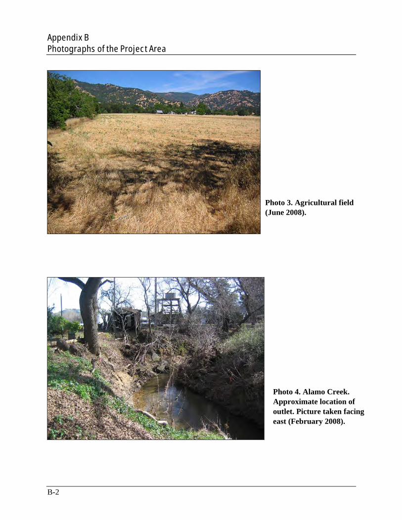
Appendix B Photographs of the Project Area
Photo 3. Agricultural field (June 2008).
Photo 4. Alamo Creek. Approximate location of outlet. Picture taken facing east (February 2008).
B-2
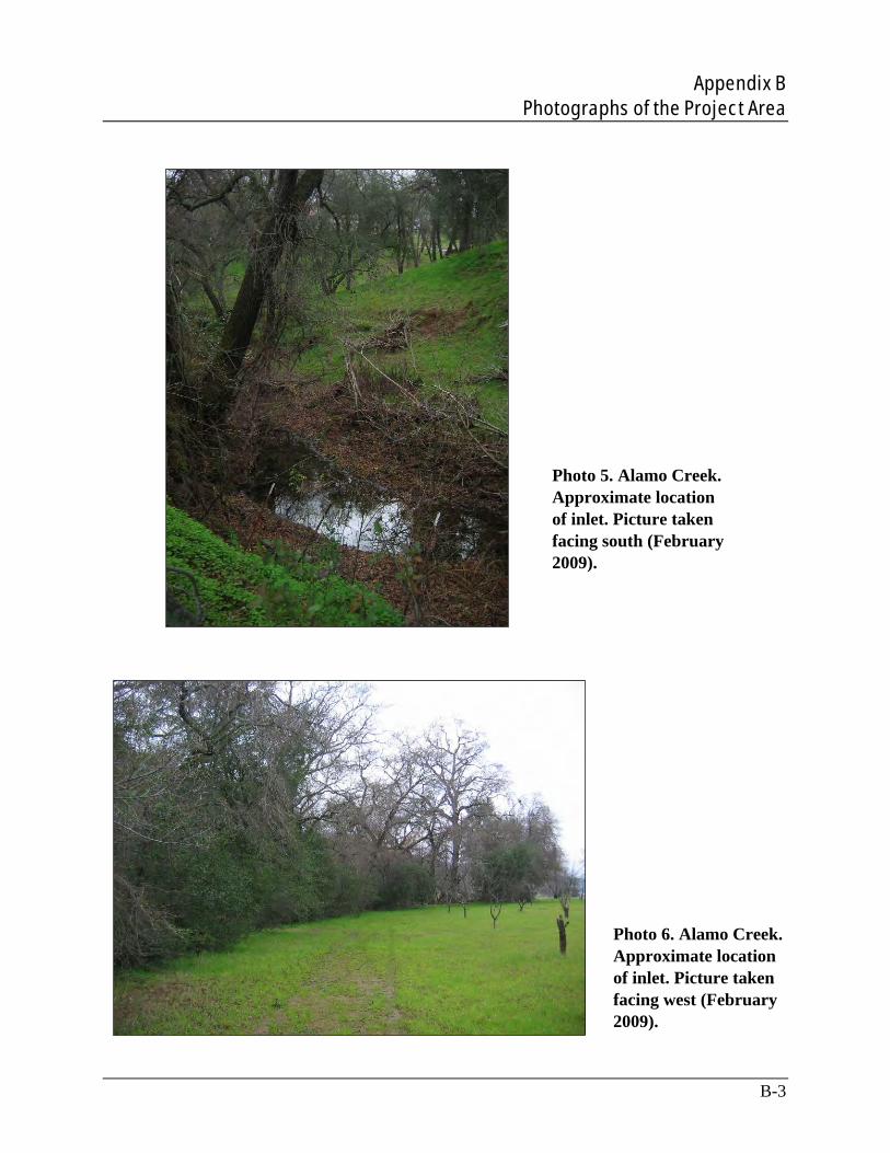
Appendix B Photographs of the Project Area
Photo 5. Alamo Creek. Approximate location of inlet. Picture taken facing south (February 2009).
Photo 6. Alamo Creek. Approximate location of inlet. Picture taken facing west (February 2009).
B-3

Appendix B Photographs of the Project Area
Photo 7. Alamo Creek (February 2008).
Photo 8. Alamo Creek (April 2008).
B-4

Appendix B Photographs of the Project Area
Photo 9. Alamo Creek (July 2008).
Photo 10. Alamo Creek (July 2008).
B-5


Appendix C: Federally Listed Species under NMFS Jurisdiction
with Potential to Occur in the Vicinity of the Project Area

Appendix C Federally Listed Species under NMFS Jurisdiction with Potential to Occur in the Vicinity of the Project Area
C-1
This appendix provides a brief overview of the listing history, life history, habitat requirements and potential for each species to occur within the project area, Alamo Creek, and other stream and river segments downstream of the project area. The six species under NMFS jurisdiction addressed in this appendix were identified in the U.S. Fish and Wildlife Service (USFWS) species search of the United States Geological Survey 7.5-minute quadrangles including and surrounding the project area: Fairfield North (project area), Denverton, Fairfield South, Cordelia, Allendale, Elmira, Mt. Vaca, Capell Valley, and Mt. George. The species are:
Green sturgeon (Acipenser medirostris), southern distinct population segment (DPS)
California Central Valley Steelhead (CCV steelhead) (Oncorhynchus mykiss), DPS
Central California Coastal steelhead (CCC steelhead) (Oncorhynchus mykiss), DPS
Central Valley spring-run (CVSR) chinook salmon (Oncorhynchus tshawytscha), evolutionary significant unit (ESU)
Sacramento River winter-run (SRWR) chinook salmon (Oncorhynchus tshawytscha), ESU
Green Sturgeon
The green sturgeon southern DPS was listed as threatened on April 7, 2006, and took effect on June 6, 2006 (71 FR 17757). The southern DPS of the green sturgeon consists of all coastal and Central Valley populations south of the Eel River, with the only known spawning population in the Sacramento River.
The green sturgeon is anadromous, spending its adult life in the ocean but ascending coastal streams in the winter where it remains to spawn the following summer. Adults typically begin migrating up the Sacramento River in February and spawn from March through July, with a peak from mid-April to mid-June (Moyle et al. 1995). Adult sturgeons occur in the Sacramento River, presumably spawning, when temperatures are between 46 and 57°F (Moyle 2002). Green sturgeon are thought to spawn every 3 to 5 years in deep pools with fast-moving water and prefer large cobble substrates, but substrate size can range from clean sand to bedrock (NOP 2001). Eggs are broadcast spawned and likely adhere to substrates or settle into crevices of river bedrock or under gravel (Deng 2000; Van Eenennaam et al. 2001; Deng et al. 2002). Adult green sturgeons are presumed to leave shortly after spawning, but larval green sturgeon may remain in the rivers and appear to move farther downstream as water flows increase.
Juvenile green sturgeons spend 1 to 4 years in fresh and estuarine waters before dispersing to saltwater in summer and fall (Beamesderfer and Webb 2002). Juvenile green sturgeon prefer temperatures of 59 to 61°F with an upper limit of 66° F (Mayfield and Cech 2004; Allen et al. 2006).
There is no potential for the green sturgeon southern DPS to occur in the project area. The geographic areas occupied by the green sturgeon consist of the natal river systems (Sacramento River, Feather River, and Yolo and Sutter bypass) and estuaries. The green sturgeon would not

Appendix C Federally Listed Species under NMFS Jurisdiction with Potential to Occur in the Vicinity of the Project Area
C-2
occur upstream of the head of the tide in non-natal freshwater rivers (73 FR 52084). There are also no recent or historical California Natural Diversity Database (CNDDB) records within the nine USGS 7.5-minute quadrangles surrounding and including the project area (CDFG 2009). Aquatic habitat in the project area does not provide the appropriate physical or biological characteristics required by this species. Juvenile green sturgeon may occur downstream from the project area in Cache Slough. Critical habitat for this species is not located in the project area.
Steelhead
Along the Pacific Coast, steelhead trout have been divided into two distinct populations segments (DPSs) based on genetic similarities and watershed boundaries. The two DPSs are the California Central Valley (CCV) steelhead DPS and the Central California Coast (CCC) steelhead DPS.
Steelhead require cool, clean, well-oxygenated water and appropriate gravel for spawning. Steelhead spawn using gravel about 0.25 to 4.0 inches in diameter, usually at the top of a riffle. Migratory corridors start downstream of the spawning areas and allow the upstream passage of adults and the downstream emigration of out-migrant juveniles. Both spawning areas and migratory corridors comprise rearing habitat for juveniles, which feed and grow before and during their out-migration. Non-natal, intermittent tributaries also may be used for juvenile rearing (Moyle 2002).
For a detailed discussion of steelhead life history, see Section 3.1.
Critical habitat for this species is not located in the project area. Potential for the two steelhead DPSs to occur in the project area is described below.
California Central Valley Steelhead
The CCV steelhead DPS was listed as threatened on March 19, 1998 (63 FR 13347), and its status was reaffirmed on January 5, 2006 (71 FR 834). The CCV steelhead DPS includes all naturally spawned anadromous steelhead populations below natural and human-made impassable barriers in the Sacramento and San Joaquin rivers and their tributaries, excluding steelhead from the San Francisco and San Pablo bays and their tributaries, as well as two artificial propagation programs: the Coleman National Fish Hatchery and Feather River Hatchery steelhead hatchery programs (71 FR 834; NMFS 2009a, 2009b).
The CCV steelhead DPS may occur in the project area. See Section 3.1 for a detailed discussion of the potential for the CCV steelhead DPS to occur in the project area.
Central California Coast Steelhead
The CCC steelhead DPS was listed as threatened on August 18, 1997 (62 FR 43937), and its threatened status was reaffirmed on January 5, 2006 (71 FR 834). The CCC steelhead DPS

Appendix C Federally Listed Species under NMFS Jurisdiction with Potential to Occur in the Vicinity of the Project Area
C-3
encompasses parts of watersheds in Marin, Sonoma, Napa, Solano, Contra Costa, Alameda, Santa Clara, San Francisco, San Mateo and Stan Cruz counties (70 FR 52488). This DPS occupies in river basins from the Russian River to Aptos Creek, some tributary streams of Suisan Marsh, and drainages of the San Francisco, San Pablo and Suisun bays eastward to the confluence of the Sacramento and San Joaquin River Basin (Napa River inclusive). The Sacramento-San Joaquin River Basin in the Central Valley of California is excluded (71 FR 834; NMFS 2009a, 2009b).
There is no potential for the CCC steelhead DPS to occur in the project area. The geographic area occupied by the CCC steelhead DPS does not include Alamo Creek or the project area (NMFS 2009a, 2009b). There are also no recent or historical CNDDB records of this species within the nine USGS 7.5-minute quadrangles surrounding and including the project area (CDFG 2009). The CCC steelhead DPS occurs a considerable distance downstream of the project area in the San Francisco, San Pablo and Suisun bays. Critical habitat for this DPS is not located within the project area.
Chinook Salmon
chinook salmon populations along the West Coast have been divided into evolutionary significant units (ESUs). chinook salmon are the largest Pacific salmon species, with adults often exceeding 40 pounds; individuals over 120 pounds have been reported.
The life history of the chinook salmon includes both freshwater and oceanic phases of development. Adults migrate from the ocean into freshwater streams of their birth to mate. Incubation, hatching, and emergence occur in freshwater, followed by migration to the ocean, at which time smoltification occurs. Maturation is initiated and completed upon return to freshwater habitats. Once maturation is complete, spawning occurs in natal streams. Adults spawn only once and then die (Moyle 2002).
Chinook salmon have two basic life history types: stream-type and ocean-type. Stream-type adult chinook salmon run up streams before they have reached full maturity, in spring or summer, and their juveniles usually reside more than 1 year in freshwater following emergence. Ocean-type adult chinook salmon spawn soon after entering freshwater, in summer and fall, and their juveniles migrate to the ocean within their first year. These variations of life history are named for the timing of spawning runs of adults such as spring-run or fall-run (Moyle 2002).
Adult chinook salmon spend 1 to 5 years in the ocean before returning to their natal stream to spawn. Once they reach their natal stream, chinook salmon select large, deep pools (more than 6 feet) with bedrock bottoms and moderate velocities for holding. Spawning occurs in areas with a substrate mixture of gravel and small cobbles with low silt content and adequate subsurface flow. Spawning sites have larger gravel and more water flow up through the gravel than the sites used by other Pacific salmon (Moyle 2002).

Appendix C Federally Listed Species under NMFS Jurisdiction with Potential to Occur in the Vicinity of the Project Area
C-4
When juvenile chinook salmon emerge from the gravel, they initially seek areas of shallow water and low velocities. As they grow, they tend to shift toward deeper and faster waters, using deep pools and heavy cover to avoid predators. The juveniles then move downstream at a wide variety of sizes and conditions, depending on whether they are ocean- or stream-type (Moyle 2002).
Central Valley Spring-Run Chinook Salmon
The Central Valley spring-run (CVSR) chinook salmon ESU was listed as threatened on September 16, 1999 (50 FR 50394), with its status reaffirmed on June 28, 2005 (50 FR 37160). The CVSR ESU includes all naturally spawned populations of spring-run chinook salmon in the Sacramento River and its tributaries in California, including the Feather River (50 FR 37160; NMFS 2009a, 2009b). CVSR chinook salmon ESU are found primarily in Butte, Big Chico, Deer, and Mill creeks. There are other waters that contain CVSR chinook salmon ESU, but the majority are found in these four tributaries to the Sacramento River (CDFG 2000).
The CVSR chinook salmon ESU spawns in the Sacramento River basin and exhibits a stream-type life history. Adults typically enter freshwater between February and July, peaking between May and June. Once they reach the spawning areas, they remain in pools until spawning occurs as early as mid-August and ending in mid October, peaking in September. Most juveniles emigrate from the tributaries as fry from mid-November through June (Goals Project 2000).
While the project area and Alamo Creek are located within the geographic range of the CVSR chinook ESU (NMFS 2009a, 2009b), there is little or no potential for the CVSR chinook salmon ESU to occur in the project area. Based on the assessments conducted by the Critical Habitat Analytical Review Teams, Alamo Creek is considered unoccupied by the CVSR chinook ESU (70 FR 52488). There are also no recent or historical CNDDB records of this species within the nine USGS 7.5-minute quadrangles surrounding and including the project area (CDFG 2009). This ESU is not currently known to occur in Alamo Creek; both historical and current migration of the CVSR chinook salmon ESU appear to be limited to the mouth of Cache Slough (NMFS 1999), which is approximately 19 miles (straight-line distance) downstream from the project area. Occupied habitat for the CVSR chinook ESU is present downstream from the project area in Cache Slough, and this ESU likely uses this segment for migration and rearing. Critical habitat for this species is not located in the project area.
Sacramento River Winter-Run Chinook Salmon
The SRWR chinook salmon ESU was listed as endangered under the ESA on January 4, 1994 (50 FR 440), with its status reaffirmed on June 28, 2005 (50 FR 37160). The ESU includes all naturally spawned populations of winter-run chinook salmon in the Sacramento River and its tributaries in California (50 FR 37160; NMFS 2009a, 2009b). SRWR chinook salmon ESU are unique to the Sacramento River, spawning in the upper Sacramento River below Keswick Dam. They typically migrate upstream as immature silvery fish and then spawn several months later in
Appendix C Federally Listed Species under NMFS Jurisdiction with Potential to Occur in the Vicinity of the Project Area
C-5
early summer. Juveniles spend between 5 and 10 months in the river and Sacramento-San Joaquin Estuary before entering the ocean (Moyle 2002).
There is no potential for the SRWR chinook salmon ESU to occur in the project area. While the project area and Alamo Creek are located within the geographic range of the SRWR chinook ESU (NMFS 2009a, 2009b), the SRWR chinook salmon ESU was not historically known to occur within Alamo Creek nor is this ESU currently known to occur in the project area or Alamo Creek (NMFS 1999). Both historical and current migration appears to be limited to the mouth of Cache Slough (NMFS 1999), which is approximately 19 miles (straight-line distance) downstream from the project area. The species likely occurs downstream of the project area within Cache Slough and uses that downstream reach for migration, holding, and rearing. Critical habitat for this species is not located in the project area. There is only one recent record of this species within the nine USGS 7.5-minute quadrangles surrounding and including the project area, which is from Montezuma Slough (Occurrence Number 5, CDFG 2009).