doi:10.1093/jdh/epw013 Drawing Natures: US Highway Journal...
18
© The Author [2016]. Published by Oxford University Press on behalf of The Design History Society. All rights reserved. Advance Access publication 21 May 2016 157 Drawing Natures: US Highway Location, Representational Techniques and the Rise of Ecological Design Margot Lystra Amidst broad disciplinary, political and technological shifts in the 1960s, a handful of US urban designers experimented with highway design, thereby reconfiguring how human/nature relationships were enacted in the studio. This paper examines the specific techniques and methods used in two such experiments: a 1962 highway location study by architect Christopher Alexander and engineer Marvin Manheim, and a 1966 highway re-routing proposal by landscape architect and urban planner Ian McHarg. In some ways, these projects support the notion that 1960s design was increasingly technological and rational in character: they exemplify a key moment when data-oriented, computer-inspired approaches were integrated into urban and environmental design, and demonstrate designers’ interests in developing more scientific, comprehensive and measurable approaches. Yet attending to these projects’ techniques and methods reveals contradictions and complications within that broader narrative. In action, 1960s designers often made the categories of nature, ecology, data and technology multiplicitous and unstable, by speaking, viewing, drawing and performing them in different ways at different moments. In focusing on the actions of designing, this work contributes a new understanding of the ecocentric dimensions of 1960s US urban design, and examines the substantive roles of drawing technique and design method in defining human/nature relationships. Keywords: 1960s—drawing—environmental design—history of technology—landscape design—modernism Introduction: humans, materials, technologies, natures In the mid-1950s György Kepes, professor in design at the Massachusetts Institute of Technology (MIT), stated that scientific and technological innovations had made the natural world newly foreign to modern humans. He encouraged designers to culti- vate this unrecognizable nature into a ‘new landscape’ by exploring its characteristics through intuitive bodily action: ‘We need to map the world’s new configurations with our senses, dispose our own activities and movements in conformity with its rhythms and discover in it potentialities for a richer, more orderly and secure human life. The sensed, the emotional, are of vital importance in transforming its chaos into order.’ 1 Twenty years later Carl Steinitz, landscape architecture professor at the Harvard Graduate School of Design and a pedagogical descendant of Kepes, advocated a mark- edly different understanding of design practices. 2 Promoting a computer-inspired ‘data file’ mapping method that could sort large amounts of landscape information, Steinitz expressed disdain for the body’s role in engaging natural processes. He likened hand drawing to the play of children, criticized its excessive cost and proclaimed that, with the computer’s advance, ‘the days of drawing board drudgery are numbered’. 3 Over doi:10.1093/jdh/epw013 Journal of Design History Vol. 30 No. 2 Downloaded from https://academic.oup.com/jdh/article-abstract/30/2/157/2623674 by Albert R. Mann Library user on 15 November 2017
Transcript of doi:10.1093/jdh/epw013 Drawing Natures: US Highway Journal...

© The Author [2016]. Published by Oxford University Press on behalf of The Design History Society. All rights reserved.Advance Access publication 21 May 2016
157
Drawing Natures: US Highway Location, Representational Techniques and the Rise of Ecological Design
Margot Lystra
Amidst broad disciplinary, political and technological shifts in the 1960s, a handful of US urban designers experimented with highway design, thereby reconfiguring how human/nature relationships were enacted in the studio. This paper examines the specific techniques and methods used in two such experiments: a 1962 highway location study by architect Christopher Alexander and engineer Marvin Manheim, and a 1966 highway re-routing proposal by landscape architect and urban planner Ian McHarg. In some ways, these projects support the notion that 1960s design was increasingly technological and rational in character: they exemplify a key moment when data-oriented, computer-inspired approaches were integrated into urban and environmental design, and demonstrate designers’ interests in developing more scientific, comprehensive and measurable approaches. Yet attending to these projects’ techniques and methods reveals contradictions and complications within that broader narrative. In action, 1960s designers often made the categories of nature, ecology, data and technology multiplicitous and unstable, by speaking, viewing, drawing and performing them in different ways at different moments. In focusing on the actions of designing, this work contributes a new understanding of the ecocentric dimensions of 1960s US urban design, and examines the substantive roles of drawing technique and design method in defining human/nature relationships.
Keywords: 1960s—drawing—environmental design—history of technology—landscape design—modernism
Introduction: humans, materials, technologies, naturesIn the mid-1950s György Kepes, professor in design at the Massachusetts Institute of Technology (MIT), stated that scientific and technological innovations had made the natural world newly foreign to modern humans. He encouraged designers to culti-vate this unrecognizable nature into a ‘new landscape’ by exploring its characteristics through intuitive bodily action: ‘We need to map the world’s new configurations with our senses, dispose our own activities and movements in conformity with its rhythms and discover in it potentialities for a richer, more orderly and secure human life. The sensed, the emotional, are of vital importance in transforming its chaos into order.’1
Twenty years later Carl Steinitz, landscape architecture professor at the Harvard Graduate School of Design and a pedagogical descendant of Kepes, advocated a mark-edly different understanding of design practices.2 Promoting a computer-inspired ‘data file’ mapping method that could sort large amounts of landscape information, Steinitz expressed disdain for the body’s role in engaging natural processes. He likened hand drawing to the play of children, criticized its excessive cost and proclaimed that, with the computer’s advance, ‘the days of drawing board drudgery are numbered’.3 Over
doi:10.1093/jdh/epw013
Journal of Design History
Vol. 30 No. 2
Downloaded from https://academic.oup.com/jdh/article-abstract/30/2/157/2623674by Albert R. Mann Library useron 15 November 2017

158Drawing Natures
the course of two decades, a ‘new landscape’ had indeed taken hold in the design professions; yet its terms, tendencies and connections to natural forces were nothing like what Kepes had imagined. How had designer/nature relationships undergone such extensive changes, and what was at stake in their transformation?
The following study investigates this question, with a particular concern for how design-ers and natures interrelate through the actions of designing.4 I examine the methods and techniques used in two US highway location projects: a 1962 highway location study by architectural theorist Christopher Alexander and transportation engineer Marvin Manheim; and a 1966 highway re-routing proposal for citizens of Princeton, NJ, by landscape architect and urban planner Ian McHarg. At a glance the representational differences between these projects appear quite subtle: mere variations in texture, tone and looseness of line. Through detailed analysis, I show that these differences in fact reveal a great deal. In a decade when US designers increasingly questioned their roles and responsibilities relative to living systems, these representational differences marked a tacit renegotiation of designer/nature relationships, enacted through the often unspo-ken acts of drawing and making. Elucidating the specific practices that comprised this renegotiation complicates our understanding of how designers engaged nature, ecol-ogy, data and technology during this period, revealing that modifications in technique and method actively reconstituted these not as discrete categories, but as fluctuating, multiplicitous and entangled entities.
The praxiographic alterations discussed here tie into broad disciplinary, political and technological shifts that occurred through the 1960s. Disciplinarily, post-war designers in the United States increasingly represented complex spatial and organizational rela-tionships through diagrammatic means, in response to expanding government bureau-cracy, growing opportunities in urban planning and the influence of abstract visual art.5 Politically, the planning of US highways prompted public debates regarding the protection and design of living environments. Proposed urban freeways were particu-larly contested; their threats to air quality, large parks and regional wildlife catalysed discussions about the character and value of urban landscapes.6 Technologically, the 1960s dissemination of wartime research brought designers novel systems thinking, new methods for using aerial imagery and experimentation with computer program-ming.7 During this decade computer use was limited, but on the rise; coupled with an increased availability of social, geographical and ecological data, the very anticipation of computerization inspired new design approaches.8
In this context, landscape architects, architects and planners often used highway pro-jects as opportunities to reimagine cities and regions, using a mix of representational innovation, ecological references, site data and systems thinking to do so. Louis Kahn, Kevin Lynch, Lawrence Halprin and Christopher Tunnard all crafted highway visions during this period. Most of these experimental projects did not result in constructed highways: some were strictly theoretical, some failed in public forums, others were meant to stop construction in the first place. Nonetheless, these projects were instru-mental; their novel approaches to natures, technologies and representation catalysed a new data-based environmentalism in design disciplines, promoting new understand-ings of designers’ roles and responsibilities relative to living beings, both human and non-human.
The selected projects by Alexander and Manheim and by McHarg are two examples of such highway designs. These works shared many similarities. Both combined scientific references, aesthetic tropes, novel uses of site data and environmental attentiveness in order to envision the living dimensions of highway environments. Both used a form
Downloaded from https://academic.oup.com/jdh/article-abstract/30/2/157/2623674by Albert R. Mann Library useron 15 November 2017

159Margot Lystra
of layered, plan-based site analysis that would later become the basis for Geographic Information Software (GIS), a tool now used globally in resource analysis and regional planning. Yet these projects were also quite different; the designers conducted their respective studies with contrasting drawing techniques, thereby cultivating markedly different forms of relationship with the natural forces they engaged.
To articulate these differences, I build upon Science and Technology Studies (STS) dis-cussions regarding naturecultures, which highlight the co-imbrication of entities tradi-tionally assigned to opposite sides of a human/non-human divide.9 In particular, I draw on works exploring the naturecultures of skilled practices as they relate to formations of knowledge and expertise, including foundational works by Donna Haraway, Bruno Latour and Andrew Pickering that highlight the relational dimensions of human/non-human interaction in inter-species relationship, visual representation, and scientific and architectural practices, respectively.10 These works share a conceptual concern for how skilled actions co-construct human and non-human roles and agencies. They also ana-lyse naturecultures in realms not typically associated with natures, such as laboratories, domestic environments and buildings. As such, they provide useful models for identify-ing human/nature relationships within design work, which largely occurs away from the sites to be designed.11
I build on these approaches in order to identify a key moment when designers incor-porated data-oriented, technology-inspired approaches into urban and environmental design, and to detail related shifts in how they connected to natural forces through drawing. I show how during this period, designs for new infrastructures, the devel-opment of ecological design, nascent computer use, and design methods and tech-niques were all bound together towards a complex modification of human/nature relationships. In doing so, I unearth dynamics and themes similar to those raised in recent works on highway landscape design by Thomas Zeller, Peter Merriman and oth-ers—such as connections between technologies and natures, the cultural and political content of landscape representation and tensions between official narratives and pro-fessional practices.12
By considering how those broad dynamics circulated through the particularities of design method and technique, I reveal ambiguities and tensions within 1960s design and planning disciplines regarding how to engage natures via scientific and techno-logical means. Although 1960s designers and planners increasingly embraced data-oriented and science-inspired means for engaging the natural world, the practices underpinning these shifts often contradicted and complicated over-arching narratives promoting technological rationalism. The emerging new techniques were collective in their distribution of drawing action, manual in their modification of hand drawing and making, performative in their attuning to how designers perceived their own roles in design process and aesthetic in their focus on visual design language as a means for communicating scientific ideas.
In attending to the dynamics of drawing and making, I illustrate that substantive encounters and negotiations among humans, materials, technologies and natures occur through the bodily actions of drawing and making, and I model new ways that historians might analyse the political and ideological dimensions of designers’ drawing techniques and design methods.13 This study thus offers a provocation to architectural, design, environmental and landscape historians alike to consider the praxiographic aspects of design—bodily, tacit uses of technique and method—as equal to both rhet-oric and built outcomes in their potential to manifest changing relationships between humans and natures.
Downloaded from https://academic.oup.com/jdh/article-abstract/30/2/157/2623674by Albert R. Mann Library useron 15 November 2017

160Drawing Natures
The Use of Diagrams in Highway Route Location: An ExperimentIn the early 1960s, Christopher Alexander was a PhD candidate in Architecture at Harvard University, working on a dissertation that would eventually be published as Notes on the Synthesis of Form.14 During this time he conducted research with Marvin L. Manheim, a PhD student in engineering at MIT. Both were interested in real-world applications for emergent computer programs. In 1962, they received funding from the Bureau of Public Roads of the US Department of Commerce and the Massachusetts Department of Public Works to conduct a highway location study for the area around Springfield, MA. The result was an MIT Research Report entitled The Use of Diagrams in Highway Route Location: An Experiment.15
Anyone familiar with GIS today will recognize the basic structure of Alexander and Manheim’s method. Using an approach outlined by MIT Engineering professor Paul Roberts in 1957, they cross-referenced numerous plan-view drawings of ‘requirements’: factors that could influence highway location.16 They produced a series of twenty-six requirement diagrams of the area of the proposed highway [1]. These included factors that highway engineers did not typically take into account at the time, such as local land development, air pollution, eyesores and noise. For each requirement, they inter-preted existing site data in order to mark the least desirable (lightest) and most desir-able (darkest) locations. For example, the ‘Weather Effects’ diagram [2] used broad washes of grey, outlined colourless areas and dark grey/black curving forms to repre-sent challenges posed by various weather conditions, as determined by interrelating topographic data with information regarding atmospheric conditions. Curving forms darkly coloured the south-east sides of hills, which were desirable highway locations because they were sheltered from prevailing north-east winds. Areas of fog and unbro-ken crosswinds were undesirable highway locations, so they were represented with light tones or no colour. Once drawn, the requirement drawings were cross-referenced and retraced repeatedly in nesting series, until all drawings had been distilled into one final image [3, ‘A’]: this was the solution to the highway location problem.
As far as Alexander and Manheim were concerned, the nesting order they devised for cross-referencing requirements was the crux of their experiment. Their structure for correlating drawings reflected a larger interest in designing computer programs that could deploy combinatory pathways to solve design problems.17 But while their prob-lem structure was based on computation, their visual analysis was more traditional: achieved through a mix of photographic and hand drawing techniques.
Alexander and Manheim only briefly described these techniques in writing, explaining how they superimposed and compared requirement drawings. They first used multiple partial exposures to combine the negatives of two or three photographed drawings into a single image. (e.g. 4, ‘6+17+24’).18 The composite image was then projected onto a drawing board, and Alexander and Manheim traced over the darkest areas of the image with path-like patterns (e.g. 4, ‘G’). Next, these new path drawings were overlain with other similarly produced path drawings, and the darkest areas traced again. This combining and tracing was continued until the final path drawing was achieved [3, ‘A’].
Alexander and Manheim described their path drawing process as follows:
When we superimpose these diagrams mechanically, the areas where this rein-forcement occurs come out blackest, of course. However, in this first composite, these dark areas will be discontinuous, zigzagging, running in several directions at once, of unclear overall shape, etc. In other words, the mechanically composite
Downloaded from https://academic.oup.com/jdh/article-abstract/30/2/157/2623674by Albert R. Mann Library useron 15 November 2017

161Margot Lystra
photograph is a relatively unstructured pattern of greys. However, the eye, being what it is, we can always detect an underlying pattern in such a diagram, and we can bring this underlying structure out. This process is known as ‘leveling and sharpening’. It is usually defined as the process of establishing the basic pattern properties of a stimulus more firmly than they exist in the original stimulus. The effect of redrawing the original composite, then, is to bring out just the kinds of property a highway has to have as a ‘path’.19
Hand drawing was thus used in two ways: first, in interrelating existing site data to identify the locational qualities of each requirement; secondly, in creating path draw-ings by refining and clarifying (‘leveling and sharpening’) perceptible patterns in the photographs of combined requirement drawings.
For example, Alexander and Manheim derived a single combined path diagram from requirements 6 (Interference During Construction), 17 (Weather Effects) and 24 (Existing Transportation Systems) [4]. The composite image ‘6+17+24’ was created photographically and projected on the drawing board, as described above. Alexander and Manheim then applied multiple layers of charcoal or graphite on the paper onto which the composite image was projected—simultaneously looking for the darkest areas of the projection, and using their drawing hands to transform those areas into path-like forms. The drawing process was technical (using multiple photographic expo-sures), perceptive (relying on the seeing eye to discern areas of greatest darkness) and interpretive (translating composite dark areas into hand-drawn paths on paper). Revelation took place through making and observing together; manual drawing and analytical observation were practised as one inseparable act.
This reliance on hand drawing may seem out of place given that the project’s concern was computer-based decision-making.20 That out of place quality is actually signifi-cant, for it points to where Alexander and Manheim did not innovate. In relying on hand drawing for visual interpretation, they maintained a connection to a modernist
Fig 1. The twenty-one requirements used in Alexander and Manheim’s highway location study: ‘Earthwork Costs’, ‘Comfort and Safety’, ‘Regional Development’, ‘Local Land Development’, ‘Obsolescence’, ‘Interference During Construction’, ‘User Costs’, ‘Services’, ‘Travel Time’, ‘Pavement and Subgrade Costs’, ‘Drainage Patterns’, ‘Bridge Costs’, ‘Land Costs’, ‘Eyesores’, ‘Noise’, ‘Air Pollution’, ‘Weather Effects’, ‘Non-Recompensable Public and Private Losses’, ‘Public Financial Losses’, ‘Major Current Traffic Desires’, ‘Catchment Areas’, ‘Local Accessibility and Integrity’, ‘Future Transportation Systems’, ‘Existing Transportation Systems’, ‘Duplication of Facilities’ and ‘Self-Induced Congestion’. Christopher Alexander and Marvin L. Manheim, The Use of Diagrams in Highway Route Location: An Experiment (Cambridge, MA: School of Engineering, Massachusetts Institute of Technology, 1962), 7. © Massachusetts Institute of Technology (1962). Reproduced with permission from the Massachusetts Institute of Technology
Downloaded from https://academic.oup.com/jdh/article-abstract/30/2/157/2623674by Albert R. Mann Library useron 15 November 2017

162Drawing Natures
tradition of cultivating the bodily actions of design as a means for engaging natural forces.
The citations in Alexander and Manheim’s report suggest that this hand-based approach to decision-making was at least partly intentional.21 For example, when stating that ‘the eye, being what it is, can always detect an underlying pattern in such a diagram, and we can bring this underlying structure out’, they cited Gestalt psychologists and theorists Rudolf Arnheim, Friedrich Wulf, Wolfgang Köhler and Kurt Gottschaldt.22 These references aligned Alexander and Manheim with an understanding of the view-ing human body as inherently equipped to perceive the patterns and structures of a larger natural order. It also linked them to Bauhaus-associated modernist designers and artists who drew on Gestalt theories, such as Kepes, who would later publish a piece by Alexander in his 1966 edited volume The Man-Made Object.23
These references to Gestalt also point to a broader tradition of biocentrism within Bauhaus design.24 Alexander was connected to this tradition through both his studies at the Harvard Graduate School of Design and his research at MIT: Bauhaus-based ped-agogies held sway at both institutions during the 1960s.25 More evidence of biocen-trism can be found in Alexander’s Notes on the Synthesis of Form, which was written
Fig 2. Requirement 17, ‘Weather Effects’, diagram (above) and base map (below). ‘This requirement is concerned with the vulnerability of the highway to the effects of weather conditions: floods, snowdrifts on the windward sides of hills, ice on the pavement in the shadows of cuts and underpasses, fog in dips of the road into marshy hollows, unbroken crosswinds, smoke from local conditions, etc.’ Christopher Alexander and Marvin L. Manheim, The Use of Diagrams in Highway Route Location: An Experiment (Cambridge, MA: School of Engineering, Massachusetts Institute of Technology, 1962), 68–69. © Massachusetts Institute of Technology (1962). Reproduced with permission from the Massachusetts Institute of Technology
Downloaded from https://academic.oup.com/jdh/article-abstract/30/2/157/2623674by Albert R. Mann Library useron 15 November 2017

163Margot Lystra
at the same time as the highway study. Here Alexander cited figures such as Lancelot Whyte and Albert Dalcq, who influenced modernist notions of biology and ecology from the early twentieth century through the post-war years.26
Both Alexander and Manheim’s highway project and Alexander’s writing, then, were resonant with recurring inquiry among modernist designers regarding how to cultivate embodied design practices that could encounter, mediate and reinforce the agencies of natural forces. This theme was often touched upon in modernist design pedagogy, and was carried over from early Bauhaus Vorkurs courses through the later development of Basic Design teaching methods at various US institutions.27
Many of Alexander’s references in Notes on the Synthesis of Form reinforced this reso-nance. When discussing the challenge of using diagrams to represent natural forces and forms, he explicitly cited Kepes, Paul Klee and Louis Kahn.28 Alexander’s reference to Kepes involved his work with photographs of observed phenomena. Regarding this work, Kepes stated that the artist ‘only assists at the birth of a living form that grows from deeper strata than his conscious efforts could reach. He invents techniques that give the fewest obstacles to the free flow of organic information.’29 Regarding Klee, Alexander referred to his discussion of the arrow in Pedagogical Sketchbook, which opened with an association between thought, drawing body and landscape: ‘the father of the arrow is the thought: how do I expand my reach? Over this river? This lake? That mountain?’30 In mentioning Kahn, Alexander focused on his suggestion that architects should enter into dialogue with their materials, asking what a given form ‘wants to be’. Alexander echoed this idea in his own writing, proposing, for example, that the designer should ‘determine, as abstractly as possible, the physical relation which each individual tendency is seeking’.31 All of these references illustrate Alexander’s desire to work in a way that was interactive with and responsive to natural forces, as perceived and explored through the actions of drawing.
Fig 3. Diagram showing the final recommended highway location (‘A’, top), as well as the two path drawings (‘B’, ‘C’) used to determine the final solution. Christopher Alexander and Marvin L. Manheim, The Use of Diagrams in Highway Route Location: An Experiment (Cambridge, MA: School of Engineering, Massachusetts Institute of Technology, 1962), 21. © Massachusetts Institute of Technology (1962). Reproduced with permission from the Massachusetts Institute of Technology
Downloaded from https://academic.oup.com/jdh/article-abstract/30/2/157/2623674by Albert R. Mann Library useron 15 November 2017

164Drawing Natures
This approach to drawing as a receptive and reciprocal act is also apparent in the arte-facts of Alexander and Manheim’s drawings, whose openness as part of an ongoing process of deduction is apparent. Outlined forms are rarely present, and gradient shifts between dark and light defy clear categorization. In the variability and texture of line, evidence of the maker’s hand remains, hinting at a process that is not closed—not definitively marked on the page as absolute—but rather left ambiguous. In this rep-resentational looseness and roughness the drawings are not fixed and finished, but rather malleable, available for further interpretation and manipulation. Furthermore, this openness visibly references how the drawings were made: through sketching by hand, in a process that engaged revelation through making. By inviting and maintain-ing generative ambiguity in these ways, Alexander and Manheim developed a drawing practice that, while circumscribed by structure, was nonetheless relationally interactive and open to uncertainty and change.
In Alexander and Manheim’s highway location drawings, then, one finds a way of working that understood the drawing body as innately equipped to perceive, direct and manifest qualities and forces intrinsic to living beings and natural forces. As in the work of those who Alexander cited as influences, this understanding was both theo-rized in text and enacted through drawing. Alexander and Manheim’s study thereby extended a lineage of modernist architects and artists who understood and engaged drawing as a mediation of natural forces, a productive encounter in which the actions of generating patterns and forms operated as active dialogue with complex, living processes.
Further reinforcing the human/nature connection, the environment explored in these practices was in no way pristine, but rather interrelated with technological artefacts and innovations. For example, Alexander and Manheim integrated into the design pro-cess topographic maps and multiple-exposed photographs, as indicators of natural forces. They used economic data in various requirement analyses. And they sometimes understood their own designing bodies in fairly scientific terms, particularly regarding
Fig 4. Diagram showing the overlay and path drawing process for requirements 6 (Interference During Construction), 17 (Weather Effects) and 24 (Existing Transportation Systems). ‘6+17+24’ shows the overlay image of the three requirements; ‘G’, at top, is the path diagram marking the darkest areas seen in the overlay image. Christopher Alexander and Marvin L. Manheim, The Use of Diagrams in Highway Route Location: An Experiment (Cambridge, MA: School of Engineering, Massachusetts Institute of Technology, 1962), 17. © Massachusetts Institute of Technology (1962). Reproduced with permission from the Massachusetts Institute of Technology
Downloaded from https://academic.oup.com/jdh/article-abstract/30/2/157/2623674by Albert R. Mann Library useron 15 November 2017
165Margot Lystra
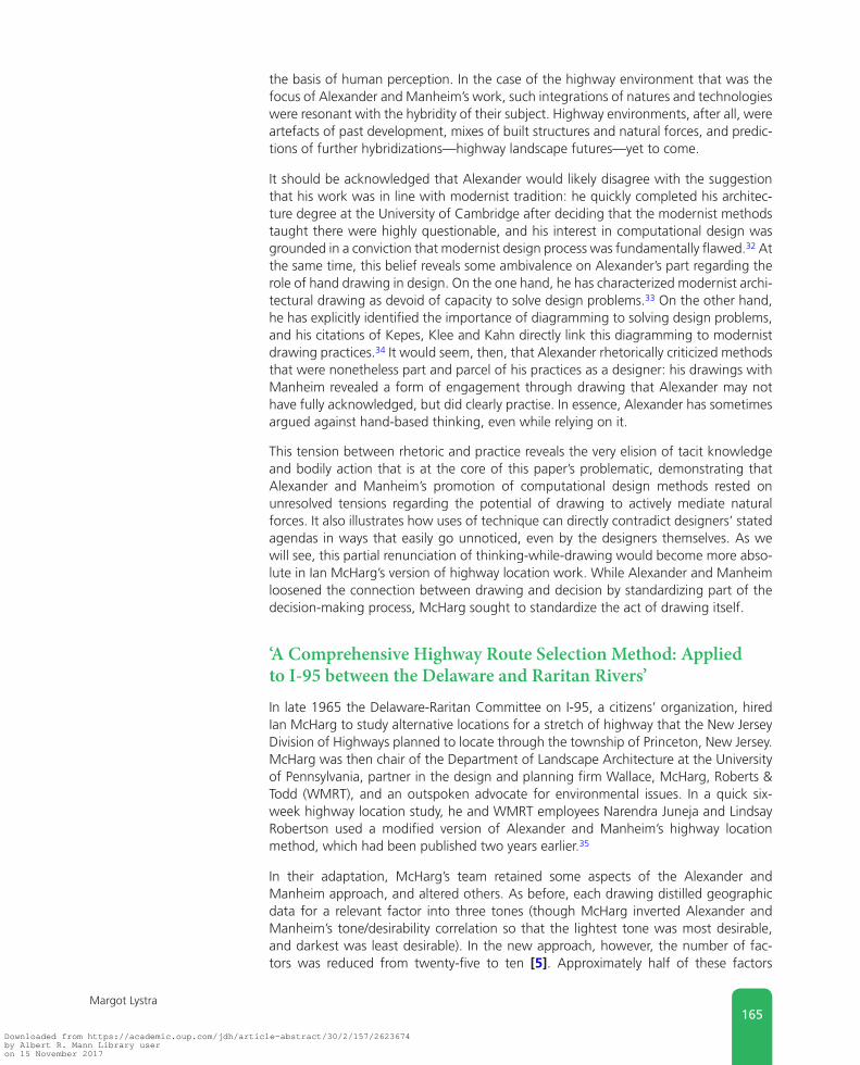
the basis of human perception. In the case of the highway environment that was the focus of Alexander and Manheim’s work, such integrations of natures and technologies were resonant with the hybridity of their subject. Highway environments, after all, were artefacts of past development, mixes of built structures and natural forces, and predic-tions of further hybridizations—highway landscape futures—yet to come.
It should be acknowledged that Alexander would likely disagree with the suggestion that his work was in line with modernist tradition: he quickly completed his architec-ture degree at the University of Cambridge after deciding that the modernist methods taught there were highly questionable, and his interest in computational design was grounded in a conviction that modernist design process was fundamentally flawed.32 At the same time, this belief reveals some ambivalence on Alexander’s part regarding the role of hand drawing in design. On the one hand, he has characterized modernist archi-tectural drawing as devoid of capacity to solve design problems.33 On the other hand, he has explicitly identified the importance of diagramming to solving design problems, and his citations of Kepes, Klee and Kahn directly link this diagramming to modernist drawing practices.34 It would seem, then, that Alexander rhetorically criticized methods that were nonetheless part and parcel of his practices as a designer: his drawings with Manheim revealed a form of engagement through drawing that Alexander may not have fully acknowledged, but did clearly practise. In essence, Alexander has sometimes argued against hand-based thinking, even while relying on it.
This tension between rhetoric and practice reveals the very elision of tacit knowledge and bodily action that is at the core of this paper’s problematic, demonstrating that Alexander and Manheim’s promotion of computational design methods rested on unresolved tensions regarding the potential of drawing to actively mediate natural forces. It also illustrates how uses of technique can directly contradict designers’ stated agendas in ways that easily go unnoticed, even by the designers themselves. As we will see, this partial renunciation of thinking-while-drawing would become more abso-lute in Ian McHarg’s version of highway location work. While Alexander and Manheim loosened the connection between drawing and decision by standardizing part of the decision-making process, McHarg sought to standardize the act of drawing itself.
‘A Comprehensive Highway Route Selection Method: Applied to I-95 between the Delaware and Raritan Rivers’In late 1965 the Delaware-Raritan Committee on I-95, a citizens’ organization, hired Ian McHarg to study alternative locations for a stretch of highway that the New Jersey Division of Highways planned to locate through the township of Princeton, New Jersey. McHarg was then chair of the Department of Landscape Architecture at the University of Pennsylvania, partner in the design and planning firm Wallace, McHarg, Roberts & Todd (WMRT), and an outspoken advocate for environmental issues. In a quick six-week highway location study, he and WMRT employees Narendra Juneja and Lindsay Robertson used a modified version of Alexander and Manheim’s highway location method, which had been published two years earlier.35
In their adaptation, McHarg’s team retained some aspects of the Alexander and Manheim approach, and altered others. As before, each drawing distilled geographic data for a relevant factor into three tones (though McHarg inverted Alexander and Manheim’s tone/desirability correlation so that the lightest tone was most desirable, and darkest was least desirable). In the new approach, however, the number of fac-tors was reduced from twenty-five to ten [5]. Approximately half of these factors
Downloaded from https://academic.oup.com/jdh/article-abstract/30/2/157/2623674by Albert R. Mann Library useron 15 November 2017

166Drawing Natures
addressed social and economic issues, and the other half addressed geographic and ecological ones.
Most significantly, this new highway location analysis altered its precedent’s mapping technique. This was manifested in three ways. First, McHarg’s team mostly relied on direct tracing of source data, whereas Alexander and Manheim’s process had involved cross-referencing and reinterpreting more than one set of data (as described above, regarding ‘Weather Effects’). Second, in lieu of their precedent’s hand-drawn sketches on paper, McHarg’s team used adhesive film on sheets of transparent plastic.36 The team’s ‘Agricultural value’ map [6], for example, was based on an Engineering Soils Survey from Rutgers University. After determining that the only viable agricultural land in the area corresponded with United States Department of Agriculture (USDA) Category II soils, the team retraced those areas on the Rutgers map that demarcated Category II soils. They used these traces as cut-lines for adhe-sive film, and applied the cut film to plastic sheets. The resulting map essentially reformatted the source data. Its use of film to do so resulted in hard edges, closed forms and three even shades, rather than Alexander and Manheim’s sketched lines, open forms and gradient of shades.
The McHarg team’s third alteration of the drawing process involved simplifying their precedent’s pattern of combination; rather than iteratively combining and retracing drawings in nested subsets, they combined all the drawings at once. Once plotted and composed, all ten transparent drawings were stacked together and photographed, resulting in a single composite image [7, bottom]. The team then overlaid another drawing sheet and marked the recommended highway route (plus a couple alternate paths) through the lightest areas in the composite drawing. This final drawing of the
Fig 5. The ten factors included in the McHarg team’s I-95 location analysis, combined into one image by the present author. Factors are ‘Topography’, ‘Land values’, ‘Urbanization’, ‘Residential quality’, ‘Historical value’, ‘Agricultural value’, ‘Recreational values’, ‘Wildlife values’, ‘Water values’ and ‘Susceptibility to erosion’. From Ian L. McHarg, ‘A Comprehensive Highway Route Selection Method: Applied to I-95 between the Delaware and Raritan Rivers’, Highway Research Record 246 (1965): 6, Fig 1; 7, Fig 2; 8, Figs 3, 4; 9, Figs 5, 6; 10, Figs 7, 8; 11, Fig 9; 12, Figs 10, 11; 13, Fig 12. Copyright, National Academy of Sciences, Washington, DC, 1968. Reproduced with permission from the Transportation Research Board
Downloaded from https://academic.oup.com/jdh/article-abstract/30/2/157/2623674by Albert R. Mann Library useron 15 November 2017

167Margot Lystra
recommended route was also represented with trans-parent plastic [7, top]. With this shift, the McHarg team eradicated their precedent’s phased process of ‘leveling and sharpening’.
Together, these three adjustments reduced opportuni-ties for the kind of interpretive drawing that Alexander and Manheim had used. As we have seen, although Alexander and Manheim’s drawings were similarly comprised of referencing and tracing over base maps and aerials, they also involved hand-mediated deci-sions regarding how to draw different sources of data together; choices of thickness of line, shape of pattern and depth of tone; and interpretive transla-
tions of requirement shapes into path-like forms. In the McHarg version, Alexander and Manheim’s sixteen interpretive path drawings were replaced with one interpre-tive drawing, which did not occur until all drawings were complete and collated. As McHarg explained, ‘the method was known but the evidence was not. It was necessary to await compilation, make the transparent maps, superimpose them over a light table and scrutinize them for their conclusion.’37 In essence, the McHarg team’s approach significantly reduced in-process moments of decision, resulting in fewer opportunities for designers to make choices while drawing.
In light of the association between embodied drawing techniques and engaging natu-ral forces that I have traced above, McHarg’s modification of Alexander and Manheim’s drawing process was tantamount to breaking with prior modernist understandings of the designer/nature relationship. To be clear, these shifts in technique did not neces-sarily result in a reduced decision-making role for the designer, but rather, a reduced decision-making role for the drawing designer. In McHarg’s version of highway loca-tion, viewing replaced drawing as the primary thinking action, so there were far fewer opportunities for the individual drawing body to operate as a living, corporeal, interpre-tive conduit for natural forces within the design process.
Of course, in renouncing old configurations, the McHarg team also initiated new ones. For one, they amplified the role of data as corollary for natural forces. Undergoing little drawing-based re-interpretation, the data that the team traced, cross-referenced and measured remained largely unaltered through the design process. Drawing, meanwhile, became more closely tied to calculation and careful fidelity to source data. McHarg’s students were trained in this fidelity: for example, they were taught throughout the 1960s how to use of planimeters and dot grids, tools traditionally used by foresters and geologists for plotting and calculating the square footage of different bound areas within a map.38 Under McHarg, source data increasingly stood for natural forces within design process, as drawing was honed towards its precise reconstitution.
Under McHarg in the 1960s, drawing also became a more distributed act, shared among more designers and mediated through more tools of measurement. Photographs of University of Pennsylvania landscape architecture students from the late 1960s and early 1970s show this distribution in action. In some photographs, groups of students sit together with pencils in hand, clustered around a single drawing. Other photos show the analysis projects of prior years’ studio projects pinned on the wall for students to reference as they conduct their own analyses.39 These images show that drawing practices were not only more standardized, but more collective and dispersed than preceding practices.
Fig 6 . ‘Agricultural value’ map, I-95 project. Ian L. McHarg Papers, From Ian L. McHarg, ‘A Comprehensive Highway Route Selection Method: Applied to I-95 between the Delaware and Raritan Rivers’, Highway Research Record 246 (1965): 9, Fig 6. Copyright, National Academy of Sciences, Washington, DC, 1968. Reproduced with permission from the Transportation Research Board
Downloaded from https://academic.oup.com/jdh/article-abstract/30/2/157/2623674by Albert R. Mann Library useron 15 November 2017

168Drawing Natures
These praxiographic shifts bore a complex relation-ship to McHarg’s concurrent growing interest in ecology. In the years surrounding the I-95 project, McHarg embraced ecology as both a conceptual driver for design and as a source of legitimation for the field of landscape architecture. Under his direction, the University of Pennsylvania landscape architecture department developed a novel ecol-ogy-based pedagogy in the 1960s, expanding the biological component of the curriculum beyond its prior focus on botany and horticulture. This inno-vation reflected McHarg’s environmental politics, as well as his firm belief that by incorporating eco-logical principles the field of landscape architecture could develop a new relevance, in both regional planning processes and society at large. According to McHarg, with the use of ecology ‘the caprice and arbitrariness of “clever” designs can be dismissed forever. In short, ecology offers emancipation to landscape architecture.’40 Regarding the design pro-cess, McHarg described ecology as a potentially all-powerful force, providing ‘the perception of form, an insight to the given form, [and] implication for the made form’.41
But what exactly was this essential, liberating ecol-ogy that McHarg so avidly invoked? In lectures and writings he specifically promoted scientific ecology as a source of comprehensive, objective solutions for design problems. And yet, as with Alexander’s discussion of modernist drawing technique, this was another circumstance where rhetoric and prac-tice failed to align. McHarg’s ‘ecological’ design innovations drew less on scientific approaches than on the shifts in method and technique described above. Indeed, the I-95 drawings were calibrated to appear more technical and objective than they actually were: despite being based on somewhat scant and biased data, their imagery carried a distinctly unbiased appearance.42 Their smooth textureless precision and delineated forms evoked the clarity of topography and soil maps, but without offer-ing the same level of detail. This vagueness made bias difficult to discern: rotated off true North and lacking the location of natural features or nearby towns, the drawings were unmoored from place data that a viewer might easily recognize and reference. In addition, the use of adhesive film elided all evidence of hand-drawing; without the marks of the individual human hand carrying traces of subjectivity and fallibility, the drawings appeared abstract, neutral, and absolute.43
Politically, McHarg’s pairing of rhetoric and representation proved to be highly con-vincing.44 Combining verbal invocations of scientific authority with categorical, mul-tiply authored, abstract drawings was particularly effective in government forums, where legal and bureaucratic frameworks privileged quantification over evocation. Referencing science also advertised the under-recognized field of landscape architec-ture as a realm of expertise, and suggested that nascent environmentalist concerns had basis in solid fact. McHarg’s ‘ecological design’ approach calibrated and collectivized
Fig 7. Final composite image (top) and proposed highway path overlain on the composite image (bottom), I-95 location analysis, arranged by the author. From Ian L. McHarg, ‘A Comprehensive Highway Route Selection Method: Applied to I-95 between the Delaware and Raritan Rivers’, Highway Research Record 246 (1965): 13, Fig 12 (‘Least social cost alignment corridor’); 12, Fig 11 (‘Composite of all values in the area’). Copyright, National Academy of Sciences, Washington, DC, 1968. Reproduced with permission from the Transportation Research Board
Downloaded from https://academic.oup.com/jdh/article-abstract/30/2/157/2623674by Albert R. Mann Library useron 15 November 2017

169Margot Lystra
the very materiality of natural forces and sites in ways that made them more available for governmental protection.
In summary, McHarg’s promotion of ecology manifested in methods and techniques that maintained close fidelity to source data, cultivating the designer/nature relation-ship as a matter of precise marking, distributed production and detached analysis. At the same time, this ‘ecological’ approach was less scientific than described, and less technological than it appeared. In a sense, McHarg developed an aesthetic of facticity. Essentially performative, visually persuasive and politically effective, this new approach altered how designers related to geographic data, drawing materials, governmental forums, natural forces and their own making bodies.
ConclusionBoth of these highway location projects attempted to split drawing and decision-making apart, in contrast to prior practices. As such, they marked steps towards reducing the role of drawing in design decision-making. And yet each attempted this separation in a different way, with notably different effects. Alexander and Manheim computerized deci-sion-making methods, while using hand-drawn sketches that positioned the designer as a creative mediator of immanent natural forces. McHarg altered drawing technique: minimizing the use of hand-drawing as a means for decision-making, distributing draw-ing among multiple actors, and expanding the role of visual analysis. These modifications repositioned the designer as a plotter and decoder of geographic data that stood in for the natural world, thereby locating nature beyond direct human experience.
At a glance, these projects seem to reinforce a reading of late modernism as a period when new technologies were deployed towards more objective, rational ends. Indeed, several aspects of this history support such a reading. McHarg would go on to practice and promote the I-95 approach as the ‘layer cake method’, a tool for determining the ecological value of land. He described this method in his 1969 bestseller Design With Nature, and taught generations of landscape architects and planners to use it in envi-ronmental land management and the protection of sensitive habitat. In the late 1960s Roger Tomlinson of the Canada Land Inventory and Jack Dangermond and Carl Steinitz of the Harvard Laboratory for Computer Graphics and Spatial Analysis computerized this method, forming the basis for Esri’s GIS, a software that is today used globally in resource analysis and land management. Accordingly, the highway projects discussed here were early iterations of a method for analysing and managing large regional land-scapes that would gain momentum in the following decades, propagating a designer/nature relationship defined by data and computation.
At the same time, closely analysing the praxiographic dimensions of these highway projects reveals that they engaged technology and rationality in complex and contra-dictory ways. Alexander and Manheim’s project mixed computer-based problem solv-ing with responsive and open-ended hand-drawing. McHarg’s adaptation read visually as a more technological and objective version of its precedent; yet it used no new technologies, and its embrace of science was largely rhetorical, performative and aes-thetic. Spurred towards new designer/nature relationships by emerging technologies, ecologies and roles for data in design, Alexander, Manheim and McHarg advertised those motivators as frameworks, but engaged with them as muses.
In closing, I call out three historiographic ramifications of the highway projects described above. The first concerns how we understand the history of 1960s and
Downloaded from https://academic.oup.com/jdh/article-abstract/30/2/157/2623674by Albert R. Mann Library useron 15 November 2017
170Drawing Natures
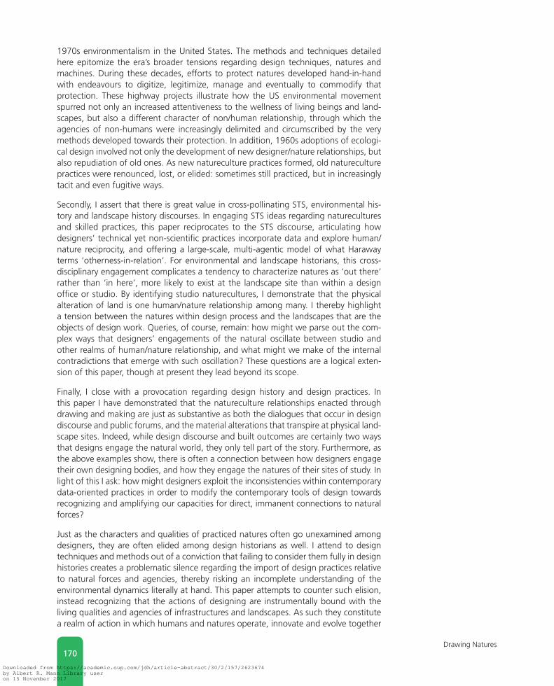
1970s environmentalism in the United States. The methods and techniques detailed here epitomize the era’s broader tensions regarding design techniques, natures and machines. During these decades, efforts to protect natures developed hand-in-hand with endeavours to digitize, legitimize, manage and eventually to commodify that protection. These highway projects illustrate how the US environmental movement spurred not only an increased attentiveness to the wellness of living beings and land-scapes, but also a different character of non/human relationship, through which the agencies of non-humans were increasingly delimited and circumscribed by the very methods developed towards their protection. In addition, 1960s adoptions of ecologi-cal design involved not only the development of new designer/nature relationships, but also repudiation of old ones. As new natureculture practices formed, old natureculture practices were renounced, lost, or elided: sometimes still practiced, but in increasingly tacit and even fugitive ways.
Secondly, I assert that there is great value in cross-pollinating STS, environmental his-tory and landscape history discourses. In engaging STS ideas regarding naturecultures and skilled practices, this paper reciprocates to the STS discourse, articulating how designers’ technical yet non-scientific practices incorporate data and explore human/nature reciprocity, and offering a large-scale, multi-agentic model of what Haraway terms ‘otherness-in-relation’. For environmental and landscape historians, this cross-disciplinary engagement complicates a tendency to characterize natures as ‘out there’ rather than ‘in here’, more likely to exist at the landscape site than within a design office or studio. By identifying studio naturecultures, I demonstrate that the physical alteration of land is one human/nature relationship among many. I thereby highlight a tension between the natures within design process and the landscapes that are the objects of design work. Queries, of course, remain: how might we parse out the com-plex ways that designers’ engagements of the natural oscillate between studio and other realms of human/nature relationship, and what might we make of the internal contradictions that emerge with such oscillation? These questions are a logical exten-sion of this paper, though at present they lead beyond its scope.
Finally, I close with a provocation regarding design history and design practices. In this paper I have demonstrated that the natureculture relationships enacted through drawing and making are just as substantive as both the dialogues that occur in design discourse and public forums, and the material alterations that transpire at physical land-scape sites. Indeed, while design discourse and built outcomes are certainly two ways that designs engage the natural world, they only tell part of the story. Furthermore, as the above examples show, there is often a connection between how designers engage their own designing bodies, and how they engage the natures of their sites of study. In light of this I ask: how might designers exploit the inconsistencies within contemporary data-oriented practices in order to modify the contemporary tools of design towards recognizing and amplifying our capacities for direct, immanent connections to natural forces?
Just as the characters and qualities of practiced natures often go unexamined among designers, they are often elided among design historians as well. I attend to design techniques and methods out of a conviction that failing to consider them fully in design histories creates a problematic silence regarding the import of design practices relative to natural forces and agencies, thereby risking an incomplete understanding of the environmental dynamics literally at hand. This paper attempts to counter such elision, instead recognizing that the actions of designing are instrumentally bound with the living qualities and agencies of infrastructures and landscapes. As such they constitute a realm of action in which humans and natures operate, innovate and evolve together
Downloaded from https://academic.oup.com/jdh/article-abstract/30/2/157/2623674by Albert R. Mann Library useron 15 November 2017

171Margot Lystra
towards new agencies, relationships and configurations. Attending to these very real interconnections reveals substantive, tacit histories within familiar narratives, thereby demonstrating that the praxiographic dimensions of design are abundantly worthy of further study.
Margot LystraHistory of Architecture and Urbanism, Cornell University, Ithaca, NY, USAE-mail: [email protected]
Margot Lystra is a PhD candidate in the History of Architecture and Urban Development at Cornell University, and holds a Master of Landscape Architecture from the Harvard Graduate School of Design and a Bachelor of Arts in Biology from Swarthmore College. She has taught landscape architectural design, representation, theory and ecology at California Polytechnic State University—San Luis Obispo and University of Detroit Mercy. Her dissertation, ‘Between Data and Drawing: Ecological Designs for Urban US Freeways, 1958–1968’, details the methodological and technical aspects of 1960s freeway proposals, illustrating the rise of systematic quantification in urban and envi-ronmental design, and articulating tensions between experiential and computational models of human-nature relationship that continue to be debated among designers and planners today. More broadly, research interests include design representation, urban environmental history and infrastructural landscapes. Her work has been published in Studies in the History of Gardens and Designed Landscapes, The Next American City and CRIT—The Journal of the American Institute of Architecture Students. As a designer, Margot has worked for Conger, Moss, Guillard, the Detroit Collaborative Design Center and various San Francisco-based landscape architecture firms.
If you have any comments to make in relation to this article, please go to the journal website on
http://jdh.oxfordjournals.org and access this article. There is a facility on the site for sending e-mail
responses to the editorial board and other readers.
Acknowledgements: This work was supported by a research grant from the Contested Global Landscapes
Theme Project of the Institute for Social Sciences, Cornell University, and an A. Henry Detweiler Traveling
Fellowship, History of Architecture and Urban Development programme, Cornell University.
Notes 1 György Kepes, The New Landscape in Art and Science
(Chicago: Paul Theobald, 1956), 18–19.
2 A doctoral student in city and regional planning at MIT in the 1960s, Steinitz worked closely with Kevin Lynch, who in turn was a colleague of and collaborator with Kepes.
3 Carl Steinitz, Paul Parker, and Lawrie Jordan, ‘Hand-drawn Overlays: Their History and Prospective Uses’, Landscape Architecture 66, no. 5 (1976): 449–454.
4 I sometimes use ‘natures’ here to reinforce the plural and contingent character of ideas and practices involving natu-ral entities, and to reference the Science and Technology Studies (STS) understandings of naturecultures that under-pin this study.
5 Andrew M. Shanken, ‘The Uncharted Kahn: The Visuality of Planning and Promotion in the 1930s and 1940s’, The Art Bulletin 88, no. 2 (2006): 310–327.
6 Beginning in the 1930s, US federal and state governments actively planned the US Interstate Highway System. After Eisenhower’s 1956 Federal Aid Highway Act, construction began in earnest, prompting ‘freeway revolts’ in numer-ous US cities. For an environmental history of US highways, see Christopher W. Wells, Car Country: An Environmental History, Seattle, WA: University of Washington Press, 2013. Regarding US urban freeway planning and poli-tics, see Mark H. Rose and Raymond A. Mohl, Interstate: Highway Politics and Policy Since 1939, Knoxville, TN: University of Tennessee Press, 2012; Joseph F. C. DiMento and Cliff Ellis, Changing Lanes: Visions and Histories of Urban Freeways, Cambridge, MA: The MIT Press, 2013; Ari
Downloaded from https://academic.oup.com/jdh/article-abstract/30/2/157/2623674by Albert R. Mann Library useron 15 November 2017

172Drawing Natures
Kelman, A River and its City: The Nature of Landscape in New Orleans (Oakland, CA: University of California Press, 2003), 197–222.
7 Reinhold Martin, Arindam Dutta and others have detailed the techno-social aspects of modernist design in the USA during this period. Reinhold Martin, The Organizational Complex: Architecture, Media, and Corporate Space, Cambridge, MA: The MIT Press, 2003; Arindam Dutta, ed., A Second Modernism: MIT, Architecture, and the ‘Techno-social’ Moment, Cambridge, MA: The MIT Press, 2013. Regarding post-war uses of aerial imagery in urban planning and design, see Sonja Duempelmann, Flights of Imagination: Aviation, Landscape, Design, Charlottesville, VA: University of Virginia Press, 2014.
8 On the anticipatory and often ‘pseudo-scientific’ character of computer-inspired design during this period, see Sean B. Keller, ‘Fenland Tech: Architectural Science in Postwar Cambridge’, Grey Room 23 (2006): 59–60.
9 Design scholars have engaged STS discourse in recent years: Kjetil Fallan has described potential uses of Actor–Network Theory in architectural research, Albena Yaneva has dem-onstrated its use in an ethnographic study of OMA’s design process and Michelle Murphy has developed a compara-bly ontological approach to architectural histories. Kjetil Fallan, ‘Traveling with Actor–Network Theory in the Land of Architectural Research’, Architectural Theory Review 16, no. 2 (2011): 184–200; Albena Yaneva, The Making of a Building: A Pragmatist Approach to Architecture, Oxford: Peter Lang, 2009; Michelle Murphy, Sick Building Syndrome and the Problem of Uncertainty: Environmental Politics, Technoscience, and Women Workers, Durham, NC: Duke University Press, 2006.
10 Pickering’s and Haraway’s works are particularly relevant here, for they each articulate how specific practices can engage naturecultures in open-ended and reciprocal ways. Haraway describes such reciprocity as ‘alertness to other-ness-in-relation’; Pickering refers to it as ‘open-ended per-formative dance of agency’. Bruno Latour, ‘Drawing Things Together’, in Representation in Scientific Practice, ed. Michael E. Lynch and Steve Woolgar (Cambridge, MA: The MIT Press, 1990), 19–68; Donna Haraway, The Companion Species Manifesto: Dogs, People, and Significant Otherness, Chicago: Prickly Paradigm Press, 2003; Andrew Pickering, ‘The Politics of Theory’, Journal of Cultural Economy 2, nos 1–2 (2009): 197–212.
11 I do not directly replicate methods used in STS, but rather draw on relevant frameworks to identify specific research questions and hone my analysis of drawing practices.
12 Thomas Zeller, Driving Germany: The Landscape of the German Autobahn, 1930–1970, New York: Berghahn Books, 2007; Peter Merriman, Driving Spaces: A Cultural–Historical Geography of England’s M1 Motorway, Hoboken,
NJ: John Wiley & Sons, 2009. See also Christof Mauch and Thomas Zeller, eds, The World Beyond the Windshield: Roads and Landscapes in the United States and Europe, Athens, OH: Ohio University Press, 2008.
13 While this account focuses on the work of urban design-ers and landscape architects, the techniques and methods discussed here are resonant with those engaged in many design disciplines since the early twentieth century; this analysis is therefore relevant to a broader discussion of design history.
14 Largely concerned with designing for complex interrela-tional systems, this book would later become influential among computer programmers. Christopher Alexander, Notes on the Synthesis of Form, Cambridge, MA: Harvard University Press, 1964.
15 Christopher Alexander and Marvin L. Manheim, The Use of Diagrams in Highway Route Location: An Experiment, Cambridge, MA: School of Engineering, Massachusetts Institute of Technology, 1962.
16 Paul O. Roberts, ‘Using New Methods in Highway Location’, Photogrammetric Engineering 23, no. 3 (1957): 563–569.
17 See a related publication, Christopher Alexander and Marvin L. Manheim, Hidecs 2: A Computer Program for the Hierarchical Decomposition of a Set which has an Associated Linear Graph, Cambridge, MA: MIT School of Engineering, 1962. While the highway location pro-ject used a tree-like combinatory pattern that worked with the capabilities of an available computer, Alexander would later renounce that problem structure in favor of more networked combinations. Alise Upitis, ‘Alexander’s Choice: How Architecture Avoided Computer-Aided Design c. 1962’, in Dutta, op. cit., 474–505; Molly W. Steenson, ‘Architectures of Information: Christopher Alexander, Cedric Price, and Nicholas Negroponte and MIT’s Architecture Machine Group’ (PhD diss., Princeton University, 2014), 37. Regarding the early development of Alexander’s work see also Keller, op. cit., 40–65; Sean B. Keller, ‘Systems Aesthetics: Architectural Theory at the University of Cambridge, 1960–1975’ (PhD diss., Harvard University, 2005).
18 Alexander and Manheim, The Use of Diagrams in Highway Route Location, p. 110.
19 Ibid., p. 111.
20 Considered more generally, this ‘out of place’ quality can be common during periods of transition between ana-logue and digital techniques. See, for example, Marissa Fessenden, ‘The Creators of Super Mario Drafted the Game on Graph Paper’, Smithsonian.com, 22 June 2015, accessed 28 April 2016. http://www.smithsonianmag.com/smart-news/creators-super-mario-drafted-game-graph-paper-180955653/?no-ist.
Downloaded from https://academic.oup.com/jdh/article-abstract/30/2/157/2623674by Albert R. Mann Library useron 15 November 2017

173Margot Lystra
21 One might conjecture that Alexander and Manheim would have used computer graphics if they could have; computer-generated plan graphics were not in general university use in 1962 (Harvard’s pioneering Laboratory for Computer Graphics and Spatial Analysis, for reference, was founded in 1964). However, Alexander’s preferences belie such con-jecture; he continued to use hand-drawn diagrams later in his career and repeatedly suggested that diagramming was essential to an effective design process. Christopher Alexander, Notes on the Synthesis of Form (Cambridge, MA: Harvard University Press, 1971), ‘Preface’; Keller, ‘Systems Aesthetics’, pp. 68–72; Steenson, op. cit., 49–54.
22 Alexander and Manheim, The Use of Diagrams in Highway Route Location, p. 112.
23 Christopher Alexander, ‘From a Set of Forces to a Form’, in The Man-Made Object, ed. György Kepes (New York: George Braziller, 1966), 96–107. Other Bauhaus figures’ interests in Gestalt thinking have also been well docu-mented. See Marianne L. Teuber, ‘Blue Knight by Paul Klee’, in Vision and Artifact: Essays in Honour of Rudolf Arnheim, ed. Mary Henle (New York: Springer, 1976), 131–151; Geert-Jan Boudewijnse, ‘Gestalt Theory and Bauhaus—A Correspondence’, Gestalt Theory 34, no. 1 (2012): 81–98. While Gestalt influences on the Bauhaus have historically been seen as reductive in character, scholars have recently revised this understanding, noting that Gestalt thinking promoted distinctly open-ended explorations of the roles of humans in the world. See Roy R. Behrens, ‘Art, Design and Gestalt Theory’, Leonardo 31, no. 4 (1998): 299–303; Julia Moszkowicz, ‘Gestalt and Graphic Design: An Exploration of the Humanistic and Therapeutic Effects of Visual Organization’, Design Issues 27, no. 4 (2011): 56–67.
24 Regarding modernist biocentrism, see Peder Anker, From Bauhaus to Ecohouse: A History of Ecological Design, Baton Rouge, LA: LSU Press, 2010; Oliver A. I. Botar and Isabel Wünsche, eds, Biocentrism and Modernism, Farnham: Ashgate Publishing Ltd, 2011; Oliver A. I. Botar, Technical Detours: The Early Moholy-Nagy Reconsidered, New York: City University of New York, 2006.
25 Although Gropius left the Graduate School of Design in 1952, Vorkurs-based Basic Design pedagogy held sway there well into the 1960s. Jill Pearlman, Inventing American Modernism: Joseph Hudnut, Walter Gropius, and the Bauhaus Legacy at Harvard (Charlottesville, VA: University of Virginia Press, 2007), 200–238.
26 Alexander, Notes on the Synthesis of Form, pp. 195–196. Alexander most likely read Whyte and Dalcq while a stu-dent at Cambridge, given both individuals’ involvements in the 1950s Independent Group exhibition ‘Aspects of Form’ and the accompanying book, Lancelot Law Whyte, ed., Aspects of Form: A Symposium on Form in Nature and Art, New York: Pellegrini & Cudahy, 1951.
27 Myriad comments regarding this theme can be found in Bauhaus-associated instructors’ writings and lectures, in both German and US contexts. See, for example, Hans Maria Wingler, The Bauhaus: Weimar, Dessau, Berlin, Chicago, ed. Joseph Stein, Cambridge, MA: The MIT Press, 1969.
28 Alexander, Notes on the Synthesis of Form, p. 209.
29 György Kepes, Language of Vision (Chicago: Paul Theobald, 1944), 194. See also A. Vallye, ‘The Middleman: Kepes’ Instruments’, in Dutta, op. cit., 162–172.
30 Paul Klee, Pedagogical Sketchbook, Sibil Moholy-Nagy (trans.) (New York: Faber & Faber, 1953), 54. For more on Klee’s ideas on connecting with the natural world via artis-tic process, see Richard Verdi, Klee and Nature (New York: Rizzoli, 1985), 191–210.
31 Alexander, ‘From a Set of Forces to a Form’, p. 101.
32 Stephen Grabow, Christopher Alexander: The Search for a New Paradigm in Architecture (Stocksfield: Oriel Press, 1983), 29–32.
33 Grabow, op. cit., 91–92.
34 Keller and Steenson have both explored Alexander’s ambiv-alence in this regard, tracking his contradictory statements and detailing the resulting unresolved tensions. Keller, ‘Systems Aesthetics’, pp. 68–72; Steenson, op. cit., 49–54.
35 McHarg never credited the Alexander and Manheim project as an influence. However, Manheim wrote that McHarg had used his and Alexander’s method, and when one compares McHarg’s earlier methods with those used in the I-95 project, the influence is apparent. Furthermore, McHarg’s omission is not a reliable indicator of influence, as he was known for failing to cite precedents. Marvin L. Manheim Papers, MIT Institute Archives and Special Collections; Anne Whiston Spirn, ‘Ian McHarg, Landscape Architecture, and Environmentalism: Ideas and Methods in Context’, in Environmentalism in Landscape Architecture, ed. Michel Conan (Washington, DC: Dumbarton Oaks Research Library and Collection, 2000), 102.
36 McHarg referred to these sheets as mylar, but accord-ing to technical texts from that period adhesive film was typically used on acetate. Ian L. McHarg, A Quest for Life: An Autobiography (New York: John Wiley & Sons, 1996), 185; Myles Boylan and D. W. Varin, Graphic Techniques: A Manual for Urban Planners. A Description of the Use of Materials, Presentation Methods, and Report Publication Procedures for Effective Graphic Communication in Urban Planning, East Lansing, MI: Michigan State University, Department of Landscape Architecture & Urban Planning, 1956.
37 Ian L. McHarg, Design With Nature (New York: American Museum of Natural History, 1969), 35.
Downloaded from https://academic.oup.com/jdh/article-abstract/30/2/157/2623674by Albert R. Mann Library useron 15 November 2017

174Drawing Natures
38 The University of Pennsylvania’s landscape architecture department syllabi and studio photographs from the 1960s and early 1970s show the teaching of various for-estry methods, including use of planimeters and dot grids, and calculation of traverses. Curriculum Documents and Student Work, 1958–1999, The Architectural Archives, University of Pennsylvania.
39 Ibid.
40 Ian L. McHarg, ‘An Ecological Method for Landscape Architecture’, Landscape Architecture 57, no. 2 (1967): 105.
41 Ibid., p. 106.
42 The I-95 documents contain several indicators of bias. For instance property value data was factored into McHarg’s analysis twice under different categories; this weighted the outcome in favour of the clients, who as Princeton residents
had the highest property values in the region. McHarg later acknowledged this bias. Ian L. McHarg Collection, The Architectural Archives, University of Pennsylvania. McHarg, Design With Nature, p. 35.
43 For a more extensive discussion regarding the pur-ported objectivity of architectural diagrams, see Paul Emmons, ‘Diagrammatic Practices: The Office of Frederick L. Ackerman and “Architectural Graphic Standards’’, Journal of the Society of Architectural Historians 64, no. 1 (2005): 4–21. For an STS-based discussion of representa-tion and objectivity, see Lorraine Daston and Peter Galison, Objectivity, New York: Zone Books, 2007.
44 Though it tends towards exaggeration, McHarg’s biogra-phy is the best single source regarding this political effec-tiveness; he also reviews the I-95 project’s governmental reception. McHarg, A Quest for Life, pp. 183–189.
Downloaded from https://academic.oup.com/jdh/article-abstract/30/2/157/2623674by Albert R. Mann Library useron 15 November 2017