DOGWOOD PORPHYRY Cu-Mo PROSPECT, BENAMBRA …crcleme.org.au/RegExpOre/Dogwood.pdf · 2009. 1....
3
© CRC LEME 2003 Dogwood Page 1 DOGWOOD PORPHYRY Cu-Mo PROSPECT, BENAMBRA TERRANE, VICTORIA Simon Maher Geological Survey of Victoria, P.O. Box 500, East Melbourne, VIC 3002 LOCATION The Dogwood Prospect is 12 km SW of Buchan, Victoria, at 37°34’25”, 148°00’31”; Bairnsdale 1:250 000 map sheet SJ55-07. DISCOVERY HISTORY Australian Anglo American Prospecting Pty Ltd (AAAP) discovered low-grade porphyry Cu-Mo mineralization at Dogwood during 1978-83 while following up Cu anomalies in drainage sediment and soil samples (Orr, 1980). Supergene chalcocite overlying the mineralization was delineated by RC and diamond drilling by CRA Exploration Pty. Limited (CRAE) during 1988-94 (Maher, 1994). Recognition of supergene Cu mineralization in the Benambra Terrane, although in this instance uneconomic, highlights the potential of numerous other porphyry Cu ± Mo ± Au prospects in the region and the importance of immobile pathfinder elements, like Mo, that can provide a vector to undiscovered acid-weathered porphyry Cu deposits. PHYSICAL FEATURES AND ENVIRONMENT The prospect lies on the southern margin of the Eastern Highlands, N of the Gippsland coastal plains at between 240-440 m AHD. Relief is mostly less than 100 m, but resistant contact-metamorphosed Pinnak Sandstone, surrounding the Kaerwut Granodiorite, forms prominent ridges up to 180 m. The climate is humid with annual rainfall around 700 mm. Mean maximum and minimum monthly temperatures are 25°C and 12°C for January and 14°C and 3°C for July (Bureau of Meteorology, 2003). GEOLOGICAL SETTING The prospect lies within the Benambra Terrane of the Lachlan Fold Belt; close to the Cassilis, Ensay, and Haunted Stream faults. The prospect occurs within the multiphase Kaerwut Granodiorite (Klicker, 1984), one of a suite of granodiorite-tonalite stocks of probable Early Devonian age that include the Bete Bolong Suite. These flank the southern half of the Buchan Rift and, with Ordovician Pinnak Sandstone country rocks, host subeconomic porphyry Cu-Mo mineralization (Figure 1). VandenBerg et al. (2000) considered that this mafic, oxidized, high-level magmatism was linked to rifting and was similar Figure 1. Simplified Early Devonian regional geology around the Buchan Rift with porphyry copper prospects (after Rajagopalan, 1999). to the Climax-type Mo intrusions that formed from lithospheric and lower crustal melts broadly coeval with strong rift-related extensional faulting. Extension and rifting are thought to have occurred in response to strike-slip faulting along the Ensay, Cassilis and Haunted Stream dextral faults. REGOLITH Weathering and tectonic history The weathering of rocks of the Dogwood prospect is linked to the tectonic evolution of SE Australia. Weathering, initiated by the Middle Devonian Tabberabberan Orogeny, continued into the Late Mesozoic, by which time it had produced a deeply weathered land surface of low relief. Break up of Gondwanaland in the mid-Cretaceous resulted in major subsidence in the Gippsland Basin, combined with major uplift of a broad belt to the N of the coastal plain. Uplift began a continuing cycle of incision and lateral erosion. The Dogwood prospect lies between the subsided and uplifted landscapes; its mid-Palaeozoic to Late Mesozoic regolith is partially preserved in resistant rocks. Three main regolith units have been recognized and their distribution is shown in Figure 2A. Miocene-Pliocene fluvial sand and gravel Remnants of a Miocene-Pliocene fluvial sand and gravel sheet occur in the northern part of the prospect. The sheet has a flat top at around 200 m AHD. Clay, from decomposed lithic clasts, and localised ferruginous cement are products of Quaternary weathering. Recessive Kaerwut Granodiorite The largest granodiorite ‘outcrop’ (400 x 400 m) has been deeply incised and lies at 280-260 m AHD. Incision commenced in the mid- Cretaceous and stripped the mid-Palaeozoic to late Mesozoic regolith. Cainozoic weathering has left a shallow but well developed pedolith and saprolith. The granodiorite is covered by 4-10 m of colluvium shed from the surrounding high-relief contact-metamorphic aureole. Resistant, leached Pinnak Sandstone Pinnak Sandstone saprolith overlain by thin soil is widespread. The pedolith has been eroded. The saprolith is pallid, fractured sandstone, siltstone and shale with abundant goethite, from intense leaching by acidic groundwater. Reflectance spectrometry (Maher, 1994) identified a supergene argillic assemblage of kaolinite-halloysite±illite. Acidic weathering, due to weathering of abundant sulphide, began in the mid Palaeozoic and continued into the late Mesozoic. The distribution of acid-weathered rocks corresponds with abundant hypogene pyrite in the sericitic alteration zone (Figure 2A). The saprolith has been protected from erosion in resistant contact-metamorphosed Pinnak Sandstone that forms a shell with an elevation of up to 440 m AHD around the Kaerwut Granodiorite. MINERALIZATION The hypogene mineralization comprises chalcopyrite and molybdenite as disseminations and stockwork veins centred on the Kaerwut Granodiorite and its apophyses and extending into the surrounding Pinnak Sandstone. The highest Cu grades rarely exceed 0.4% (best 0.5 m @ 1.65% from 168.0 m in DG1) and are centred on the granodiorite and surround inferred NE sinistral faults. Highest Mo grades are centred on the granodiorite and rarely exceed 1200 ppm (best 1 m @ 2750 ppm from 209.0 m in DG6), but Mo concentrations are also high around the faults. Propylitic alteration (chlorite-epidote-pyrite) envelops some veins close to the granodiorite and sericitic alteration (pyrite-sericite-quartz) surrounds the granodiorite (Figure 2). Weber (1999) described plagioclase cores consistent with restite mixing for one of the Bete Bolong Suite and speculated that chalcopyrite-molybdenite along joints, faults and in late dykes originated from a residual chlorine-rich fluid formed during solidification.
Transcript of DOGWOOD PORPHYRY Cu-Mo PROSPECT, BENAMBRA …crcleme.org.au/RegExpOre/Dogwood.pdf · 2009. 1....
© CRC LEME 2003 Dogwood Page 1
DOGWOOD PORPHYRY Cu-Mo PROSPECT, BENAMBRA TERRANE, VICTORIA
Simon Maher
Geological Survey of Victoria, P.O. Box 500, East Melbourne, VIC 3002
LOCATION
The Dogwood Prospect is 12 km SW of Buchan, Victoria, at 37°34’25”, 148°00’31”; Bairnsdale 1:250 000 map sheet SJ55-07.
DISCOVERY HISTORY
Australian Anglo American Prospecting Pty Ltd (AAAP) discovered low-grade porphyry Cu-Mo mineralization at Dogwood during 1978-83 while following up Cu anomalies in drainage sediment and soil samples (Orr, 1980). Supergene chalcocite overlying the mineralization was delineated by RC and diamond drilling by CRA Exploration Pty. Limited (CRAE) during 1988-94 (Maher, 1994). Recognition of supergene Cu mineralization in the Benambra Terrane, although in this instance uneconomic, highlights the potential of numerous other porphyry Cu ± Mo ± Au prospects in the region and the importance of immobile pathfi nder elements, like Mo, that can provide a vector to undiscovered acid-weathered porphyry Cu deposits.
PHYSICAL FEATURES AND ENVIRONMENT
The prospect lies on the southern margin of the Eastern Highlands, N of the Gippsland coastal plains at between 240-440 m AHD. Relief is mostly less than 100 m, but resistant contact-metamorphosed Pinnak Sandstone, surrounding the Kaerwut Granodiorite, forms prominent ridges up to 180 m. The climate is humid with annual rainfall around 700 mm. Mean maximum and minimum monthly temperatures are 25°C and 12°C for January and 14°C and 3°C for July (Bureau of Meteorology, 2003).
GEOLOGICAL SETTING
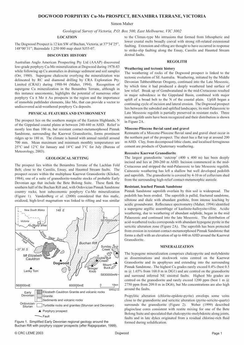
The prospect lies within the Benambra Terrane of the Lachlan Fold Belt; close to the Cassilis, Ensay, and Haunted Stream faults. The prospect occurs within the multiphase Kaerwut Granodiorite (Klicker, 1984), one of a suite of granodiorite-tonalite stocks of probable Early Devonian age that include the Bete Bolong Suite. These fl ank the southern half of the Buchan Rift and, with Ordovician Pinnak Sandstone country rocks, host subeconomic porphyry Cu-Mo mineralization (Figure 1). VandenBerg et al. (2000) considered that this mafi c, oxidized, high-level magmatism was linked to rifting and was similar
Figure 1. Simplifi ed Early Devonian regional geology around the Buchan Rift with porphyry copper prospects (after Rajagopalan, 1999).
to the Climax-type Mo intrusions that formed from lithospheric and lower crustal melts broadly coeval with strong rift-related extensional faulting. Extension and rifting are thought to have occurred in response to strike-slip faulting along the Ensay, Cassilis and Haunted Stream dextral faults.
REGOLITH
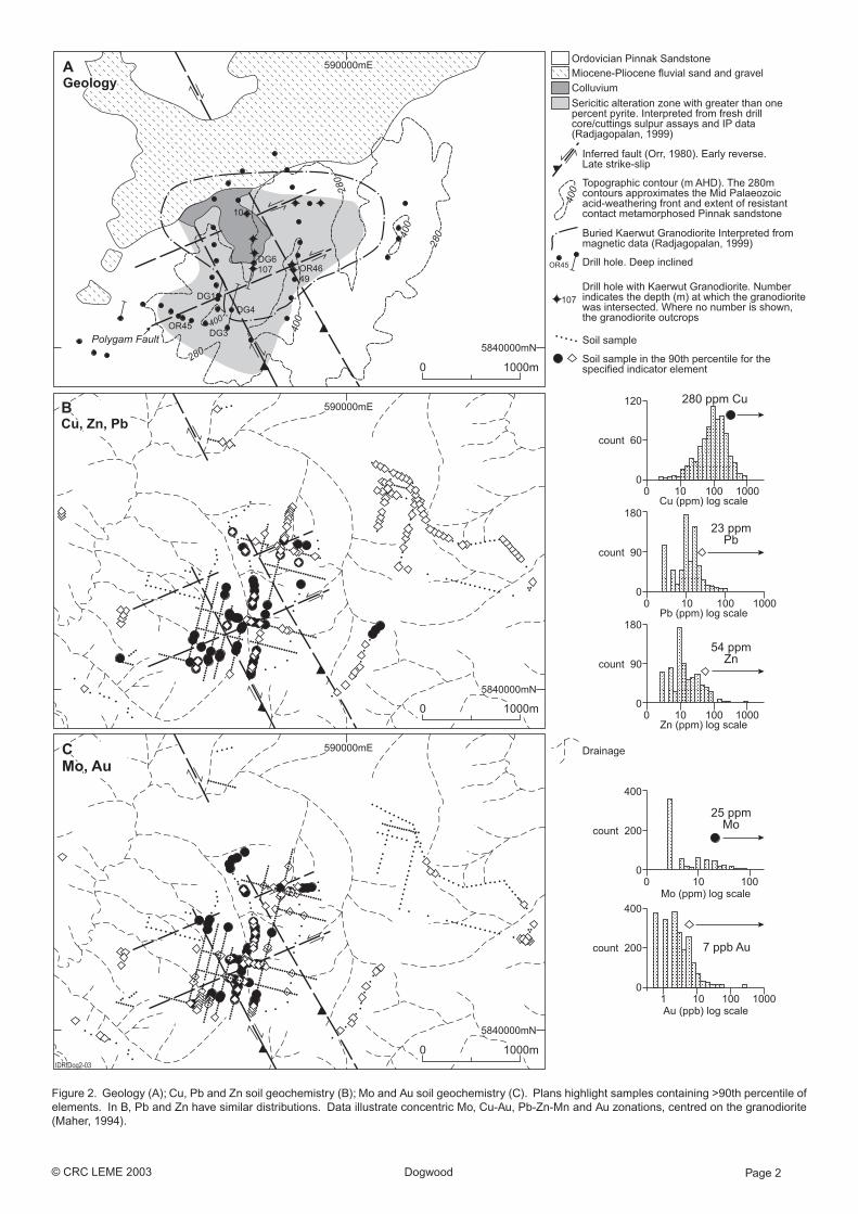
Weathering and tectonic historyThe weathering of rocks of the Dogwood prospect is linked to the tectonic evolution of SE Australia. Weathering, initiated by the Middle Devonian Tabberabberan Orogeny, continued into the Late Mesozoic, by which time it had produced a deeply weathered land surface of low relief. Break up of Gondwanaland in the mid-Cretaceous resulted in major subsidence in the Gippsland Basin, combined with major uplift of a broad belt to the N of the coastal plain. Uplift began a continuing cycle of incision and lateral erosion. The Dogwood prospect lies between the subsided and uplifted landscapes; its mid-Palaeozoic to Late Mesozoic regolith is partially preserved in resistant rocks. Three main regolith units have been recognized and their distribution is shown in Figure 2A.
Miocene-Pliocene fl uvial sand and gravelRemnants of a Miocene-Pliocene fl uvial sand and gravel sheet occur in the northern part of the prospect. The sheet has a fl at top at around 200 m AHD. Clay, from decomposed lithic clasts, and localised ferruginous cement are products of Quaternary weathering.
Recessive Kaerwut GranodioriteThe largest granodiorite ‘outcrop’ (400 x 400 m) has been deeply incised and lies at 280-260 m AHD. Incision commenced in the mid-Cretaceous and stripped the mid-Palaeozoic to late Mesozoic regolith. Cainozoic weathering has left a shallow but well developed pedolith and saprolith. The granodiorite is covered by 4-10 m of colluvium shed from the surrounding high-relief contact-metamorphic aureole.
Resistant, leached Pinnak SandstonePinnak Sandstone saprolith overlain by thin soil is widespread. The pedolith has been eroded. The saprolith is pallid, fractured sandstone, siltstone and shale with abundant goethite, from intense leaching by acidic groundwater. Refl ectance spectrometry (Maher, 1994) identifi ed a supergene argillic assemblage of kaolinite-halloysite±illite. Acidic weathering, due to weathering of abundant sulphide, began in the mid Palaeozoic and continued into the late Mesozoic. The distribution of acid-weathered rocks corresponds with abundant hypogene pyrite in the sericitic alteration zone (Figure 2A). The saprolith has been protected from erosion in resistant contact-metamorphosed Pinnak Sandstone that forms a shell with an elevation of up to 440 m AHD around the Kaerwut Granodiorite.
MINERALIZATION
The hypogene mineralization comprises chalcopyrite and molybdenite as disseminations and stockwork veins centred on the Kaerwut Granodiorite and its apophyses and extending into the surrounding Pinnak Sandstone. The highest Cu grades rarely exceed 0.4% (best 0.5 m @ 1.65% from 168.0 m in DG1) and are centred on the granodiorite and surround inferred NE sinistral faults. Highest Mo grades are centred on the granodiorite and rarely exceed 1200 ppm (best 1 m @ 2750 ppm from 209.0 m in DG6), but Mo concentrations are also high around the faults.
Propylitic alteration (chlorite-epidote-pyrite) envelops some veins close to the granodiorite and sericitic alteration (pyrite-sericite-quartz) surrounds the granodiorite (Figure 2). Weber (1999) described plagioclase cores consistent with restite mixing for one of the Bete Bolong Suite and speculated that chalcopyrite-molybdenite along joints, faults and in late dykes originated from a residual chlorine-rich fl uid formed during solidifi cation.
© CRC LEME 2003 Dogwood Page 2
Figure 2. Geology (A); Cu, Pb and Zn soil geochemistry (B); Mo and Au soil geochemistry (C). Plans highlight samples containing >90th percentile of elements. In B, Pb and Zn have similar distributions. Data illustrate concentric Mo, Cu-Au, Pb-Zn-Mn and Au zonations, centred on the granodiorite (Maher, 1994).

© CRC LEME 2003 Dogwood Page 3
The most signifi cant Cu grades are from a supergene chalcocite blanket developed over the sericitic alteration zone and preserved in contact-metamorphosed Pinnak Sandstone. Highest grades were along the conjugate Polygam Fault (Figure 2). The best intersection was 24.4 m @ 0.8% Cu as chalcocite from 65.6 m in OR46 (open at depth, including 13.3 m @ 1.1% Cu) from a pervasively sericite-quartz altered granodiorite apophysis along the fault. Grade and thickness of the supergene mineralization, and grade of primary mineralization, decrease sharply away from the fault (Maher, 1994).
REGOLITH EXPRESSION
Pinnak Sandstone, containing only 800 ppm Cu, overlies the 24.4 m @ 0.8% Polygam Fault intersection. Acidic groundwater has transported mobile metals and destroyed hypogene alteration. The sample media summary table shows depletion of Cu and Zn in acid-weathered rock compared to fresh rock. Molybdenum and Pb are relatively immobile here and are little depleted. Molybdenum can be used to map hypogene mineralization in the regolith. Figures 2B and C show broad, granodiorite-centred, hypogene metal zonation in soil. Nearly all soil and drilled samples lie within the Dogwood hydrothermal system. As a consequence, backgrounds and thresholds are not able to be determined. The geometric mean is given as a measure of central tendency for pathfi nder elements. Although the 90th percentile is arbitrary, it accurately maps the metal zonation at Dogwood (see sample media summary table and Figures 2B and 2C). The chalcocite blanket is now perched at 250-390 m AHD. Incision of the blanket around the altered Kaerwut Granodiorite has created one of the highest ranked Cu drainage sediment anomalies in E Victoria.
The chalcocite blanket was developed above the mid-Palaeozoic to late Mesozoic weathering front, now between 250 and 390 m AHD. Chalcocite commonly coats hypogene pyrite, where present. It has been preserved in resistant contact-metamorphosed Pinnak Sandstone and has been eroded around the Kaerwut Granodiorite during uplift and rejuvenation of drainage initiated in the mid-Cretaceous. Consequently, supergene mineralization on the Polygam Fault lacks the strike extent to be economic (Figure 3).
ACKNOWLEDGEMENTS
Interpretations were developed with D. Waterfi eld, I.C. Colliver and T. Aravanis. Reviews were by A. Radojkovic, A.H.M. VandenBerg and R. Buckley.
REFERENCES
Bureau of Meteorology, 2003. www.bom.gov.au/climate.
Klicker, T.M., 1984. Sedimentology, palaeovolcanology and mineralization in an associated bedded volcaniclastic and intrusive complex, Devonian Snowy River Volcanics, Bruthen-Buchan area, eastern Victoria. B.Sc. (Hons) thesis, Monash University, Melbourne (unpublished). 376 pp.
Maher, S., 1994. CRA Exploration Pty. Limited. EL 3012 Breakfast Creek. Final report. Minerals and Petroleum Expired Exploration Reports File (unpublished). 16 pp
Figure 3. Section along the Polygam Fault showing down-hole Cu and Mo. Supergene Cu enrichment, as a chalcocite blanket, occurs above the mid-Palaeozoic – Late Mesozoic acid-weathering front. The granodiorite is inferred from drilling, Rajagopalan’s (1999) magnetic interpretation and the distribution of contact metamorphosed Pinnak Sandstone.
Orr, D.B., 1980. Australian Anglo American Prospecting Limited. EL 671 Bruthen. Report for the period ending 31 March 1980. Minerals and Petroleum Expired Exploration Reports File (unpublished). 20 pp.
Rajagopalan, S., 1999. Porphyry-type copper deposits, eastern Victoria. In A.J. Willocks, S.J. Haydon, M.W. Asten, and D.H. Moore (Editors) Geophysical signatures of base metal deposits in Victoria. Report 119, Geological Survey of Victoria, pp. 113-127.
Vandenberg, A.H.M., Wilman, C.E., Maher, S., Simons, B.A., Cayley, R.A., Morand, V.J., Taylor, D.H., Moore, D., Radojkovic, A., 2000. The Tasman Fold Belt System in Victoria. Geological Survey of Victoria Special Publication, Melbourne, 462 pp.
Weber, G.B., 1999. PGM Management Pty Ltd. EL 3829 Yalmy. Annual report for the period ending 20 December 1999. Minerals and Petroleum Unexpired Exploration Reports File. (unpublished).
White, W.H., Bookstrom, A.A. and Kamilli, R.J., 1981. Character and origin of climax-type Mo deposits. In B.J. Skinner (Editor) Economic Geology 75th Anniversary Volume, 270-316.
SAMPLE MEDIA—SUMMARY TABLE
Sample
medium
Indicator
elements
Analytic
methods
Detection
limits (ppm)
Geometric
mean (ppm)
90th
percentile
(ppm)
Max anomaly
(ppm)
Dispersion
Fresh rock* Cu
Mo
Pb
Zn
Au
ICPAES
ICPAES
ICPAES
ICPAES
PM209
5’
5 & 1’
5
5
0.01
378
12
7
27
0.03
1296
213
20
72
0.06
16500
2750
1030
254
0.26
Acid-
weathered
[leached] rock^
Cu
Mo
Pb
Zn
Au
ICPAES
ICPAES
ICPAES
ICPAES
PM209
5’
5 & 1’
5
5
0.01
240
9
7
9
0.02
584
26
12
22
0.05
860
275
64
87
0.10
high
low
low
high
low
Residual soil# Cu
Mo
Pb
Zn
Au
ICPAES
ICPAES
ICPAES
ICPAES
PM205
5
5
5
5
0.001
98
6
10
14
0.002
280
25
23
54
0.007
922
100
404
1100
0.313
high
low
low
high
low
Drainage
sediment+
Cu
Pb
Zn
AAS
AAS
AAS
5
5
5
22
9
24
160
20
50
1900
70
255
high
high
high
ICPAES—mixed acid digest including HF; Inductively coupled plasma atomic Emission Spectrometry.
PM205—50 g sample: aqua regia digest—AAS/GFA.
PM209—50 g sample: fire assay—AAS.
* Includes fresh rock from CRAE and AAAP drill holes except DG3, 4 & 6. Large numbers of Kaerwut
Granodiorite samples from these holes were excluded so that the comparison between fresh rock and soil or
acid-weathered rock, that have few Kaerwut Granodiorite samples, was not biased.
‘ Samples from DG1 were analysed by AAS after perchloric acid digestion.
^ Only weathered samples without sulphide from CRAE and AAAP drill holes with substantial supergene
copper mineralization (>0.5% copper; OR9, 25, 40, 45, 46, DG1) were included in the dataset.
# CRAE unsieved samples. Samples of transported colluvium and Miocene–Pliocene fluvial sand and gravel
were excluded.
+ AAAP -80# sieved samples. Insufficient samples were analysed for Mo for these results to be included in
the analysis. No samples were analyzed for Au.