Disclaimer - Asian Disaster Reduction Center (ADRC)...2.1. History of Geological Survey. The...
72
Disclaimer This report was compiled by an ADRC visiting researcher (VR) from ADRC member countries. The views expressed in the report do not necessarily reflect the views of the ADRC. The boundaries and names shown and the designations used on the maps in the report also do not imply official endorsement or acceptance by the ADRC.
Transcript of Disclaimer - Asian Disaster Reduction Center (ADRC)...2.1. History of Geological Survey. The...

Disclaimer This report was compiled by an ADRC visiting researcher (VR) from ADRC member countries. The views expressed in the report do not necessarily reflect the views of the ADRC. The boundaries and names shown and the designations used on the maps in the report also do not imply official endorsement or acceptance by the ADRC.

Final Report for the Visiting Researcher Program in 2013
SYSTEM DEVELOPMENT OVER THE MONITORING FOR THE PURPOSE OF EARLY WARNING OF
POPULATION FROM THE THREAT OF HAZARDOUS NATURAL PROCESSES IN MOUNTAIN AND
FOOTHILL AREA REPUBLIC OF UZBEKISTAN
Prepared By
Tashpulatov Mansurjon Leading specialist
State Committee of the Republic of Uzbekistan on Geology and Mineral Resources
Visiting Researcher (ADRC) August – November 2013

2
CONTENTS
I. General Information 1.1. Republic of Uzbekistan 1.2. Japan
II. State Committee of the Republic of Uzbekistan on Geology and Mineral Resources (Goscomgeology)
2.1. History of Geological Survey 2.2. About committee 2.3. Structure of Goscomgeology 2.4. Main Tasks of Goscomgeology 2.5. Mineral resources deposits, revealed during Independence years
III. Disaster Management 3.1. Disaster Management in Uzbekistan 3.1.1. Natural Hazards in Uzbekistan 3.1.2. Disaster Management System in Uzbekistan 3.1.3. Disaster Management Strategy and Policy in Uzbekistan
3.2. Disaster Management in Japan 3.2.1. Natural Hazards in Japan 3.2.2. Disaster Management System of Japan 3.2.3. Disaster Management Strategy, Policy, and Plan in Japan
IV. Landslide Monitoring for the Ensure the Safety Population in mountain and foothill areas
4.1. Monitoring Landslides in Uzbekistan. 4.1.1. Activity State Service on Monitoring over the Dangerous Geological Processes. 4.1.2. The Structure of Monitoring. 4.1.3. The Structure of the Monitoring System and Alerting. 4.1.4. Features of Monitoring Landslide. 4.1.5. Modern Methods to Warning the Population from Landslides Disaster in Uzbekistan.
4.2. Monitoring Landslides in Japan 4.2.1. Landslide 4.2.2. Major Landslides in Recent years

3
4.2.3. Modern Methods to Waring the Population from Landslides Disaster in Japan. 4.2.3.1. Ground Survey by Means of Unmanned Helicopter 4.2.3.2. Method for Emergency Measures of Slope Failure at Roadside 4.2.3.3. Observation Method of Underground Water Level for Landslides 4.2.3.4. Clarify the Process of Landslide Transformation and Development of Estimation Method for Landslide Extent
V. Earthquake monitoring and information 5.1. Earthquake monitoring system in Uzbekistan 5.1.1. Activity of Institute Seismology of the Academy of Sciences of Uzbekistan 5.1.2. Earthquake Monitoring Network 5.1.3. Equipments for the Monitoring Earthquake 5.1.4. Information about the Latest Earthquake
5.2. Earthquake monitoring system in Japan 5.2.1. Seismic Activities and Information on Earthquake 5.2.2. Earthquake Information 5.2.3. Estimated Seismic Intensity Distribution Map 5.2.4. Information on Aftershocks of Large Earthquake 5.2.5. Earthquake Early Warning 5.2.6. Rapid and Assured Dissemination of Information 5.2.7. Earthquake Monitoring Network 5.2.8. Seismic Intensity Network 5.2.9. Basic Knowledge on Earthquake
6. Conclusion

4
I. GENERAL INFORMATION. 1.1. Republic of Uzbekistan. 1.1.1. Geography. Uzbekistan - a country located in the central part of Central Asia. Name of the State - Republic of Uzbekistan. Uzbekistan has an area of 447,400 square kilometers. It is the 56th largest country in the world by area and the 42nd by population. Among the CIS countries, it is the 5th largest by area and the 3rd largest by population. Bordering Kazakhstan and the Aral Sea to the north and northwest, Turkmenistan to the southwest, Tajikistan to the southeast, and Kyrgyzstan to the northeast, Uzbekistan is one of the largest Central Asian states and the only Central Asian state to border all the other four. Uzbekistan also shares a short border (less than 150 km) with Afghanistan to the south.

5
1.1.2. Administrative Divisions. Uzbekistan is divided into 12 provinces (viloyatlar, singular viloyat, compound
noun viloyati e.g., Toshkent viloyati, Samarqand viloyati, etc.), one autonomous
republic (respublika, compound noun respublikasi e.g. Qaraqalpaqstan Avtonom
Respublikasi, Karakalpakistan Autonomous Republic, etc.), and one independent city
(shahar. compound noun shahri, e.g., Toshkent shahri).
Division Capital City Area (km2) Population
Andijon Viloyati Andijon 4.200 2 477 900
Buxoro Viloyati Buxoro 39.400 1 576 800
Farg'ona Viloyati Farg'ona 6.800 2 997 400
Jizzax Viloyati Jizzax 20.500 1 090 900
Namangan Viloyati Namangan 7.900 2 196 200
Navoiy Viloyati Navoiy 110.800 834 100
Qaraqalpakstan Respublikasi Nukus 160.000 1 612300
Qashqadaryo Viloyati Qarshi 28.400 2 537 600
Samarqand Viloyati Samarqand 16.400 3 032 000
Sirdaryo Viloyati Guliston 5.100 698 100
Surxondaryo Viloyati Termiz 20.800 2 012 600
Toshkent Shahri Toshkent 335 2 192 700
Toshkent Viloyati Toshkent 15.300 2 537 500
Xorazm Viloyati Urganch 6.300 1 517 600
Republic of Uzbekistan
Flag
Emblem
Capital Tashkent
Ethnic groups 80.0% Uzbek
5.5% Russian
5% Tajik
3.0% Kazakh
2.5% Karakalpak
1.5% Tatar
2.5% others
Government
- President
- Prime Minister
Unitary Presidential
State
Islam Karimov
Shavkat Mirziyoyev
Legislature
-Upper house
-Lower house
Supreme Assembly
Senate
Legislative Chamber
Area
-Total
-Water (%)
447,400 km2
4.9
Population 29,559,100
Currency Uzbekistan som
6
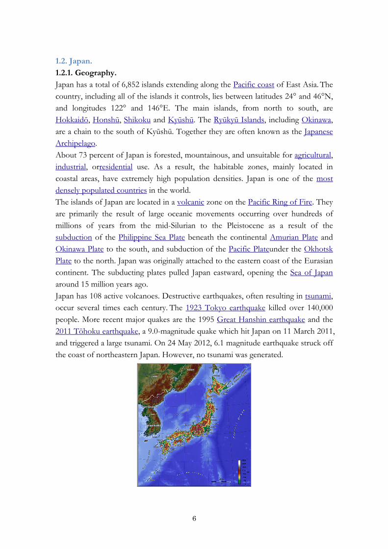
1.2. Japan. 1.2.1. Geography. Japan has a total of 6,852 islands extending along the Pacific coast of East Asia. The country, including all of the islands it controls, lies between latitudes 24° and 46°N, and longitudes 122° and 146°E. The main islands, from north to south, are Hokkaidō, Honshū, Shikoku and Kyūshū. The Ryūkyū Islands, including Okinawa, are a chain to the south of Kyūshū. Together they are often known as the Japanese Archipelago. About 73 percent of Japan is forested, mountainous, and unsuitable for agricultural, industrial, orresidential use. As a result, the habitable zones, mainly located in coastal areas, have extremely high population densities. Japan is one of the most densely populated countries in the world. The islands of Japan are located in a volcanic zone on the Pacific Ring of Fire. They are primarily the result of large oceanic movements occurring over hundreds of millions of years from the mid-Silurian to the Pleistocene as a result of the subduction of the Philippine Sea Plate beneath the continental Amurian Plate and Okinawa Plate to the south, and subduction of the Pacific Plateunder the Okhotsk Plate to the north. Japan was originally attached to the eastern coast of the Eurasian continent. The subducting plates pulled Japan eastward, opening the Sea of Japan around 15 million years ago. Japan has 108 active volcanoes. Destructive earthquakes, often resulting in tsunami, occur several times each century. The 1923 Tokyo earthquake killed over 140,000 people. More recent major quakes are the 1995 Great Hanshin earthquake and the 2011 Tōhoku earthquake, a 9.0-magnitude quake which hit Japan on 11 March 2011, and triggered a large tsunami. On 24 May 2012, 6.1 magnitude earthquake struck off the coast of northeastern Japan. However, no tsunami was generated.

7
1.2.2. Administrative Divisions. Japan
日本国
Nippon-koku
Nihon-koku
Japan consists of forty-seven prefectures, each overseen by an
elected governor, legislature and administrative bureaucracy.
Each prefecture is further divided into cities, towns and
villages. The nation is currently undergoing administrative
reorganization by merging many of the cities, towns and
villages with each other. This process will reduce the number
of sub-prefecture administrative regions and is expected to cut
administrative costs.
Flag Imperial Seal
Anthem:
"Kimigayo"
"君が代" Government Seal of Japan
五七桐 (Go-Shichi no Kiri?)
Capital Tokyo
National language Japanese
Government
- Emperor
- Prime Minister
Unitary parliamentary
constitutional monarchy
Akihito
Shinzō Abe
Legislature
- Upper house
- Lower house
National Diet
House of Councillors
House of Representatives
Area 377,944 km2
Population 126 659 683
Currency Yen (¥)

8
II. STATE COMMITTEE OF THE REPUBLIC OF UZBEKISTAN ON GEOLOGY AND MINERAL RESOURCES (GOSKOMGEOLOGY). 2.1. History of Geological Survey. The beginning of regular studying of geology of Central Asia has began in 60th years XIX century when the first geological maps of Turkestansky region and summary reports on minerals have been made. In 1920, The Central Asia University (nowadays National University of Uzbekistan named after Mirzo Ulugbek) initiated training for experts-geologist. In 1926, Central Asia Department of Committee of Geology (SAO Geolcom) which in 1930 transformed to the Central Asia regional geological survey (SARGRU), was organized. In 1937, there is a Central Asia Geology Trust, and in 1938 – Uzbek Geological Agency of the Committee on geology and subsoil protection USSR. During the period 1941-45, Uzbek geological agency was purposefully carrying out prospecting and exploration for fuel and energy and strategic raw material. During the period 1946-57, intense geological researches were carried out, for their realization, specialized enterprises for prospecting and exploration for petroleum, gas, non-ferrous, rare and precious metals, mining chemical and industrial minerals, and construction materials. In 1957, geological survey of the various ministries and departments were integrated, and General Geology and Subsoil Protection Office at Cabinet Council. On 17th of January 2007, the Order of the President of Republic of Uzbekistan “About measures on radical improvement of arrangement of exploration and activity of State Committee of the Republic of Uzbekistan on Geology and mineral resources” that had given a powerful impulse to branch development. On 12th of February 1991, according to Decree of the President of Uzbekistan of Republic of Uzbekistan №UP-142 the State committee of the Republic of Uzbekistan on geology and mineral resources (Goscomgeology RUz) was formed. On 23rd of September 1994, Oliy Mazhlis passed the “Subsoil Law RUz”, and on 13th of December 2002, its redraft was approved.

9
2.2. About committee. State committee of the Republic of Uzbekistan on geology and mineral resources carries out geologic analysis of entrails with the purpose of strengthening and development of the mineral base of the mining and process industry, provides coordination of different branches of industry connected to the geologic analysis of entrails of the territory of Uzbekistan, carries out the state control over the geologic analysis of entrails by all enterprises and organizations irrespective of patterns of ownership, creates and provides functioning of a databank on the geologic structure of entrails and mineral resources of the republic, conducting the State balance on mineral reserves, etc. with the purpose of definition of conditions of their economic and rational use.

10
2.3. Structure of Goscomgeology.
2.4. Main Tasks of Goscomgeology.
Implementation of a unified state policy in the field of geological study, use and protection of subsoil and reproduction of mineral resources, the implementation of public administration in the field of mining relations;
Organization of geological exploration of mineral resources, forecasting and identifying fields for geological and economic evaluation of mineral resources (except hydrocarbons), justification of the possibility of subsoil use for purposes not related to the extraction of mineral resources;
Management, within their competence, the state subsoil fund and the state fund of geological materials of stone, as well as specially protected geological objects;
coordination of activities related to geological exploration in Uzbekistan (with the exception of work on hydrocarbons).

11
2.5. Mineral resources deposits, revealed during Independence years.

12
III. DISASTER MANAGEMENT. 3.1. Disaster Management in Uzbekistan. 3.1.1. Natural Hazards in Uzbekistan. Natural Hazards Likely to Affect the Country. Uzbekistan ranks high among countries that have endured significant loss of life and property due to earthquakes and other natural disasters. As one of the most seismic active regions in Central Asia, Uzbekistan is struck by earthquakes in the eight to ten point ranges. In addition to its seismic vulnerability, Uzbekistan is affected by hydro-meteorological hazards affecting the agricultural sector with seasonal floods and periods of drought. Other threats from landslides, locust invasions and avalanche have been reported to affect the lives and livelihood of Uzbekistan’s population.
3.1.2. Disaster Management System in Uzbekistan. Administrative System The State system of prevention and emergency response consists of controls and capabilities of the Council of Ministers of the Republic of Karakalpakstan, 12 regions, districts and municipalities, ministries and departments, enterprises, institutions and organizations. The structure and functioning of the state system of prevention and emergency action by the Cabinet of Ministers of the Republic of Uzbekistan. The Cabinet of Ministers of the Republic of Uzbekistan: - ensures the creation of state reserves of financial and material resources for disaster management, as well as the procedure for its use; - Responsible for financial and resource support capabilities for the prevention and liquidation of emergency situations, equip them special appliances and other material and technical means; - Classification of states of emergency situations and determines the degree of involvement of the executive power to eliminate them; - carry out the activities of ministries, departments, local authorities in the protection of population and territories from emergency situations. Specially authorized state body for the protection of the Ministry of Emergency Situations for Emergency Situations of the Republic of Uzbekistan.

13
Ministry of Emergency Situations: - develop and adopt action to prevent emergency situations save lives and preserve health, protect the material and cultural values, as well as the recovery and reduce damages in emergency situations; - organizes the development and implementation of targeted programs and research in the field of population and territories from emergency situations; - takes within their jurisdiction, obligatory for execution by ministries, departments, enterprises, institutions and organizations, officials and citizens; - organize the preparation of controls, forces and protection frames the population and territories for actions in emergency situations; - controls the forces and means for dealing with emergencies, creates a control posts, warning systems and communications; - organizes the emergency rescue and other emergency operations in emergency situations; - carries out state control over the implementation protection measures the population and territories from emergency situations. Legal System and Framework of DM in Uzbekistan. The Ministry of Emergency Situations of the Republic of Uzbekistan is a central government body responsible for directing and coordinating activities in the field of civil protection, prevention and response to emergency situations caused by accidents, catastrophes and natural disasters. Ministry of Emergency Situations of the Republic of Uzbekistan in accordance with the Constitution, laws and other acts of the Oliy Majlis of the Republic of Uzbekistan, decrees, regulations, and orders of the President of the Republic of Uzbekistan, resolutions and orders of the Cabinet of Ministers and the international treaties of the Republic of Uzbekistan on the management Emergencies. Ministry of Emergency Situations of the Republic of Uzbekistan carries out its activities in cooperation with the Council of Ministers of the Republic of Karakalpakstan, regions, cities, districts, environmental and specially authorized state bodies. Ministry of Emergency situations has few documents for disaster management of the Republic of Uzbekistan. There are:

14
Structure of Disaster Management.
CABINET OF MINISTERS OF THE REPUBLIC OF UZBEKISTAN
MINISTRY OF EMERGENCY SITUATIONS
GOVERNING BODIES
МИНИСТЕРСТВА И ВЕДОМСТВА
МИНИСТЕРСТВА И ВЕДОМСТВА
МИНИСТЕРСТВА И ВЕДОМСТВА
MINISTRIES AND DEPARTMENTS ОРГАНЫМЕСТНОГО САМО-
УПРАВЛЕНИЯ ХОКИМИЯТЫ РК ОБЛАСТЕЙ
ОРГАНЫМЕСТНОГО САМО-УПРАВЛЕНИЯ ХОКИМИЯТЫ РК ОБЛАСТЕЙ
ОРГАНЫМЕСТНОГО САМО-УПРАВЛЕНИЯ ХОКИМИЯТЫ РК ОБЛАСТЕЙ
LOCAL AUTHORITIES (SUPREME COUNCIL OF THE
REPUBLIC OF KARAKALPAKHSTAN,
KHOKIMIYATS (MAYOR’S OFFICE ) OF THE OBLASTS AND
TASHKENT CITY)
CAPABILITY
EARLY WARNING AND COMMUNICATION SYSTEM
DAY-TO-DAY OPERATION BODIES
RESERVES FOR FINANCIAL AND
PHYSICAL RESOURCES
EARLY WARNING AND COMMUNICATION SYSTEM
LOCAL LEVEL
CAPABILITY
EARLY WARNING AND COMMUNICATION SYSTEM
ENTITY LEVEL
OPERATIONAL SUBSYTEM OF SSES
DAY-TO-DAY OPERATION BODIES
RESERVES FOR FINANCIAL AND
PHYSICAL RESOURCES
GOVERNING BODIESGOVERNING BODIES
DAY-TO-DAY OPERATION BODIES
CAPABILITY
RESERVES FOR FINANCIAL AND
PHYSICAL RESOURCES
TERRITORIAL SUBSYTEM OF SSES
NATIONAL LEVEL
3.1.3. Disaster Management Strategy and Policy in Uzbekistan. For the implementation of the state policy in the field of vital interests of the individual, society and the state act legal framework regulating the activities the state authorities and enterprises and organizations, as well as civil self in the area of civil

15
protection. The Laws of the Republic of Uzbekistan "On protection of population and territories from emergency situations of natural and man-made" and "Civil Protection", and a number of resolutions of the Cabinet of Ministers. The world practice shows that timely prevention of hazards of natural and man-made hazards, the priority realization of measures to prevent and reduce their negative impacts are much more economical and more effective than emergency response. In order to realize these tasks, the Ministry of Emergency Situations together with the interested ministries and departments of the Republic of Uzbekistan, the Council of Ministers of the Republic of Karakalpakstan, regional and Tashkent city State program is designed to forecast and prevention of emergency situations (hereinafter - the State program). The purpose of this state program is provide a guaranteed level of protection of the population and territories from emergency situations, risk reduction and mitigation of accidents and natural disasters in the country, taking into account achievements of the national science and technology, as well as international experience in this field. The State Program included the fallowing: А. Natural disaster risk reduction
1. Risk reduction program for the effects of earthquake 2. Program on prevention of floods, mudflows, avalanches and landslides 3. Program on prevention of epidemics, epizootic outbreak, epiphytoties
B. Technological disaster risk reduction 4. Program on prevention of chemical emergency 5. Program on prevention of accidents at explosive and fire hazardous sites 6. Program on prevention of accidents at the sites and power network 7. Program on prevention of transport accidents and disaster (motor transport, railway, aircraft, the Metro) 8. Program on prevention of disaster at hydraulic engineering structures
C. Early warning of population 9. Program on creation of territorial and local systems and early warning
D. Improvement of emergency rescue services 10. Program on equipping the Center on training and advanced training of rescue workers of MoES with rescue gear, equipment, outfit and on construction of training centers
E. Training of the population on disaster preparedness

16
11. Program on training of population 3.2. Disaster Management in Japan. 3.2.1. Natural Hazards in Japan. Natural Hazards Likely to Affect the Country.
Japan is affected by Typhoon mostly every year and Volcanic disasters triggered by eruption and volcanic earthquake. Japan is earthquake prone area due to the geological formation with plate boundaries of the Pacific plate, the Philippine Sea plate, the Eurasian plate, and the North American plate.
Recent Major Disasters. Great Hanshin-Awaji Earthquake (January 1995) on 17 January 1995, an earthquake with a 7.3 on the Richter scale occurred at Awaji island of Hyogo Prefecture in Western Japan. It killed 6,434 people, injured 43,792 people, destroyed 104,906 houses, half destroyed 144,274 houses, and partially destroyed 390,506 houses. By the fires broke out along with the earthquake, the area of 835,858 square meters was burnt down.
Mid Niigata Prefecture Earthquake (October 2004) on 23 October 2004, the Mid Niigata Prefecture was affected by an earthquake with a 6.8 on the Richter scale. Landslides and destruction of buildings and houses caused 68 dead, and 4,805
17
injured. 3,175 houses were totally destroyed, 13,810 houses were half destroyed, and 105,573 houses were partially destroyed.
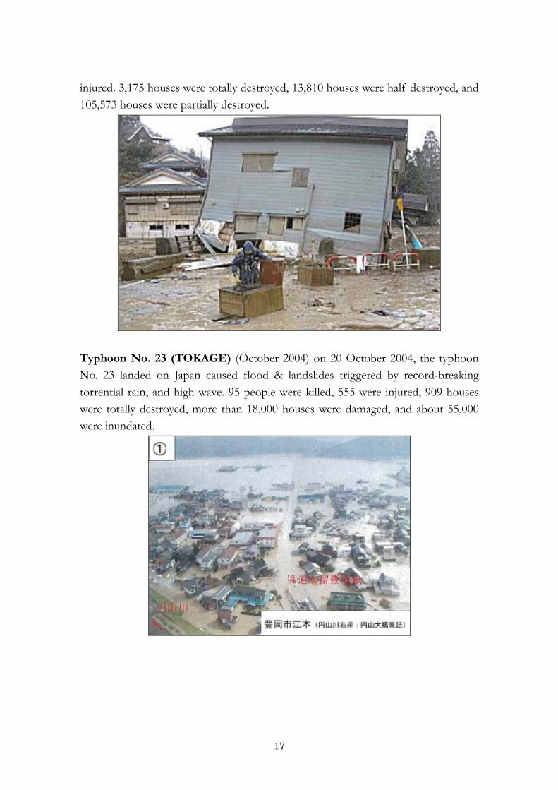
Typhoon No. 23 (TOKAGE) (October 2004) on 20 October 2004, the typhoon No. 23 landed on Japan caused flood & landslides triggered by record-breaking torrential rain, and high wave. 95 people were killed, 555 were injured, 909 houses were totally destroyed, more than 18,000 houses were damaged, and about 55,000 were inundated.

18
3.2.2. Disaster Management System of Japan. Administrative System Japan has three (3) administrative levels of governance; national, prefectural and municipal. Each level of governments has its own disaster management organizations, policy frameworks and budgets. When disasters occur, municipalities respond first. In case disasters are large in scale beyond their capacity, national and prefectural governments provide every possible support.
National Level
Prime Minister
Central Disaster Management Council
Designated Administrative Organs
Designated Public Corporations
Formulation and execution of disaster management plan, Comprehensive coordinationFormulation and promoting execution of the Basic DisasterManagement Plan
Formulation and execution of the Basic DisasterManagement Plan
Governor
Prime Minister
Prefectural DM Council
Designated Local Administrative Organs
Prime Minister
Prime Minister
Municipal Level
Formulation and execution of disaster management plan, Comprehensive coordination
Formulation and promoting execution of the Basic DisasterManagement Plan
Formulation and execution of disaster management plan, Comprehensive coordination
Formulation and promoting execution of the Basic DisasterManagement Plan
Residents Level
Responsibilities by Administrative Level
Prefectural Government Level
Legal System and Framework. In order to applying to all of the disaster phases of prevention, mitigation and preparedness, emergency response as well as recovery and rehabilitation, relevant laws and regulations were enacted. The cornerstone of legislation on disaster risk reduction is the Disaster Countermeasures Basic Act enacted in 1961. The main features of the Act are;
Responsibilities of national and local governments as well as the private sector and people, Organization of multi-sectoral coordination bodies for disaster risk management at the national and local levels, Disaster risk management planning system, Basic actions to be taken in each phase of the disaster management cycle: prevention/preparedness, emergency response, and recovery/rehabilitation, and Annual Government Official Report on Disaster Countermeasures

19
Relevant laws are as follows. Fig. 3-2-1 shows the progress of the legislative system for disaster risk reduction in Japan. 〔Basic Acts〕
1. Disaster Countermeasures Basic Act (1961) 2. Act on Prevention of Marine Pollution and Maritime Disaster (1970) 3. Act on Disaster Prevention in Petroleum Industrial Complexes and other Petroleum Facilities (1975) 4. Act on Special Measures for Large-scale Earthquakes (1978) 5. Act on Special Measures for Nuclear Disasters (1999) 6. Act on Special Measures for Promotion of Tonankai and Nankai Earthquake Disaster Management (2002) 7. Act on Special Measures for Promotion of Disaster Management for Trench-type Earthquakes in the Vicinity of the Japan and Chishima Trenches (2004)
〔Disaster Prevention and Preparedness〕 1. Erosion Control Act (1897) 2. Building Standard Law (1950) 3. Forest Act (1951) 4. Act on Temporary Measures for Disaster Prevention and Development of Special Land Areas (1952) 5. Meteorological Services Act (1952) 6. Seashore Act (1956) 7. Landslide Prevention Act (1958) 8. Act on Special Measures for Disaster Prevention in Typhoon-prone Areas (1958) 9. Act on Special Measures for Heavy Snowfall Areas (1962) 10. River Act (1964) 11. Act on Prevention of Steep Slope Collapse Disaster (1969) 12. Act on Special Measures for Active Volcanoes (1973) 13. Act on Special Financial Measures for Urgent Earthquake Countermeasure Improvement Projects in Areas for Intensified Measures (1980) 14. Act on Special Measures for Earthquake Disaster Countermeasures (1995) 15. Act on Promotion of the Earthquake-proof Retrofit of Buildings (1995) 16. Act on Promotion of Disaster Resilience Improvement in Densely Inhabited Areas (1997)

20
17. Act on Promotion of Sediment Disaster Countermeasures for Sediment Disaster Prone Areas (2000) 18. Specified Urban River Inundation Countermeasures Act (2003)
Progress in Disaster Management Laws and Systems

21
Structure of Disaster Management. a) National Platform for Disaster Risk Reduction. Under the Disaster Countermeasures Basic Act, the Central Disaster Management Council was formed, its brief being to ensure the comprehensiveness of disaster risk management and to discuss matters of importance with regard to disaster management. The council consists of the Prime Minister, who is the chairperson, Minister of State for Disaster Management, all ministers, heads of major public institutions such as the Bank of Japan, the Japanese Red Cross Society, NHK (public broadcasting corporation) and NTT (telecommunication company) and some academic experts. The duties of the Council are: i) formulation and promotion of implementation of the Basic Disaster Prevention Plan and Earthquake Countermeasures Plans; ii) Formulation and promotion of implementation of the urgent measures plan for major disasters; iii) Deliberating important issues on disaster reduction according to requests from the Prime Minister or Minister of State for Disaster Management (basic disaster management policies, overall coordination of disaster countermeasures and declaration of state of disaster emergency), and iv) Offering opinions regarding important issues on disaster reduction to the Prime Minister and Minister of State for Disaster Management.
Organization of Central Disaster Management Council

22
The Council organizes the Committees for Technical Investigation on the themes as listed below for carrying out the duties.
On countermeasures for the Tonankai and Nankai Earthquakes (formed October, 2001)
On lessons learned from past disasters (formed July, 2003) On the promotion of Nationwide Movement of Disaster Management (formed December, 2005)
On evacuation measures for the Tokyo Inland Earthquakes (formed August, 2006)
On large-scale flood countermeasures (formed August, 2006) On countermeasures for the Tokai Earthquake (March 2002 - May 2003) On information sharing for disaster management (October 2002 - July
2003) On the promotion of disaster reduction activities by the private sector (September 2003 - October 2005)
On countermeasures for the Tokyo Inland Earthquake (September 2003 - July 2005)
On countermeasures for the Trench-type Earthquakes in the Vicinity of the Japan and Chishima Trenches (October 2003 - January 2006
b) National Organizations for Disaster Risk Reduction
All the line ministries and agencies have responsibility to take actions related to disaster reduction within their own mandate. The Cabinet Office is responsible for formulating basic policies, strategies and guidelines for disaster reduction and for securing coordination of government disaster reduction activities. Within the Cabinet Office, which is the secretariat for the Central Council, the Minister of State for Disaster Management has been assigned as the Minister State for Special Missions to take lead in the responsibilities for disaster reduction in the Natural Government. The Minister is assisted by the department of the Cabinet Office Director-General for Disaster Management. The Director-General has mandate to handle planning and central coordination with regard to matters relating to basic policy on disaster risk reduction, and matters concerning disaster countermeasures in the event of a large-scale disaster.

23
Central Disaster Management Council
c) Local Organizations for Disaster Risk Reduction In prefectures and local municipalities, the prefectural and municipal Disaster Management Councils are established with the members of representatives of local government organizations including police and fire management department, and designated local public corporations. Implementation of disaster risk management measures is based on the Local Disaster Management Plans drafted by the Councils.
3.1.3. Disaster Management Strategy and Policy in Uzbekistan. Basic Disaster Prevention Plan is the master plan and a basis for disaster reduction activities in Japan. Basic Disaster Prevention Plan is prepared by the Central Disaster Management Council in accordance with Article 34 of the Disaster Countermeasures Basic Act. The plan clarifies the duties assigned to the Government, public corporations and the local government in implementing measures. For easy reference to countermeasures, the plan also describes the sequence of disaster countermeasures such as preparation, emergency response, recovery and reconstruction according to the type of disaster.

24
Basic Disaster Prevention Plan has been reviewed annually and amended as needed. In a recent review in February 2008, the Basic Plan was revised based on the lessons learned in the recent disasters and the deliberation in the Central Council including the view points of necessity to take follow-up measures of priority issues and to facilitate nationwide movement for disaster reduction. Besides of the Basic Disaster Prevention Plan, Disaster Management Operation Plan is made as a plan for each designated government organization and designated public corporation, and Local Disaster Management Plan is drafted as a plan for each prefectural and municipal disaster management council, based on the Basic Disaster Management Plan.
National Emergency Response Flow
Stand-by at 24 hrs x 7 days basisCollection and Analysis of Disaster and Damage InformationInformation-sharing with Prime Minister and Related Organizations
Inter-Ministerial Headquarters for Emergency Response
Analysis of Scale of Damage
Cabinet Information Collection Center
Prime Minister
Emergency Response Team composed of Senior Officials from Ministries
Large-scale Disaster
Cabinet Office
Minister of Statefor Disaster Management
within 30 minutes
Stand-by at 24 hrs x 7 days basisCollection and Analysis of Disaster andDamage InformationInformation-sharing with PrimeMinister and Related Organizations
Inter-Ministerial Headquarters for Emergency Response
Analysis of Scale of Damage
Cabinet Information Collection Center
Prime Minister
Emergency Response Team composed of Senior Officials from Ministries
Large-scale Disaster
Cabinet Office
Minister of Statefor Disaster Management
Further, disaster reduction perspectives are incorporated into relevant development plans such as Comprehensive National Development Plan, Social Infrastructure Development Priority Plan, Land Use Plan and urban and rural planning.

25
IV. LANDSLIDE MONITORING FOR THE ENSURE THE SAFETY POPULATION IN MOUNTAIN AND FOOTHILL AREAS 4.1. Monitoring Landslides in Uzbekistan. 4.1.1. Activity State Service on Monitoring over the Dangerous Geological Processes. On the basis of the Resolution of the Cabinet of Ministers Republic of Uzbekistan№ 194 in 1994 was established State Service on Monitoring over the Dangerous Geological Processes to monitoring the formation and development of landslides, rock falls , subsidence , suffusion and forecasting of natural and resulting from the economic activity of hazardous geological processes on the territory of the Republic of Uzbekistan in order to warning the local authorities and management of ministries, state committees and departments and other government and economic management of their possible catastrophic forms for decision-making and implementation of activities under the notification of the population , protection of human settlements and economic facilities from the effects of these processes. Main Tasks of State Service on Monitoring:
Identification of areas of dangerous geological processes and the evaluation of their activation;
Organization of monitoring; State control of dangerous geological processes; Preparation and issuance of recommendations;
Also Warning the local public authorities, relevant ministries, state committees
and agencies of the possible activation of hazardous processes shall issue recommendations on the organization of observations of dangerous geological processes, and for the State Service on Monitoring is equipped with the necessary means warning, and can use the system alerts the Office Civil Defence and Emergencies (as agreed with the Head of the Office of Civil Defence and Emergency);
Gives engineering and geological information about the development of dangerous geological processes, findings and prescriptions for taking action to prevent or mitigate their negative impacts;
Agree upon to local government authorities, ministries, state committees and departments to current and perspective plans use of territories, including projects for industrial and civil construction, in the areas of dangerous

26
geological processes and issues conclusions about the possibility of their development and other.
4.1.2. The Structure of Monitoring. The Structure of the State Service on Monitoring consists of the following:
Information analytical group; Central control communication; Topo-block; Geophysical department and’ 7 monitoring station of the Republic of Uzbekistan.
The information-analytical group
STATE MONITORING SERVICE FOR HAZARDOUS GEOLOGICAL
PROCESSES Central control communication
Topo-block Geophysical department
Angren MS Bostanlik MS Samarqand MS
Qarshi MS. ShahrisabzMS
SurhandaryaMS
Fergana MS
AREAL MONITORING STATIONS

27
Monitoring stations
4.1.3. The Structure of the Monitoring System and Warning. Structure monitoring dangerous geological processes - more attention is not paid to the forecast, and the hazard assessment and the Prevention of process. On this basis a system of monitoring of dangerous geological processes consists of 4 blocks:
OBSERVATION ASSESSMENT CONTROL WARNING

28
4.1.4. Features of Monitoring Landslide.
Daily transmission of information results observation from monitoring stations to Central Control communication of SMS, where it generalizes forwarded to the Council of SMS;
Council of SMS reviewed daily results of observations of atmospheric precipitation forecasts, fluctuations in flow rate water springs various trends of landslides and makes the following recommendations;
At the most hazardous events immediately sent to information of the Ministry of Emergency Situations and other interested agencies.
Practically conducted daily control of the results of observations. 4.1.5. Modern Methods to Warning the Population from Landslides Disaster in Uzbekistan. Identifying and study of the areal development of dangerous geological processes performed carrying out route engineering geological studies. The study of the dynamics and mechanism of large landslide is carried using high-precision measuring devices of different types. For the indirect study of the geological structure, water cut landslide arrays are used geophysical methods, such as vertical electrical sensing of using a digital device made in Japan. For the direct study of the geological structure, lithology and watercut of the array landslide performed drilling activity using machine tool company YBM. The study of the deformation and displacement of landslide dynamics of arrays is performed using the method of geodetic satellite navigation (GPS), extensometers, deformometer, inclinometers. Study of the groundwater level, determining the number and intensity of precipitation, as the main factors contributing to the formation and development of dangerous geological processes is performed using electronic gauges and rain gauges in different versions.

29
GPS method 500 (Switzerland). Geodetic Satellite Navigation System Leica GPS System 500 (with software SKI-Pro) - the automatic mode, you can get an increment of geodetic coordinates and elevations of points with no direct line your visibility between them in a more operational mode. Technical characteristics GPS receivers can determine the location bench mark accurate to 10 mm, increasing the accuracy of the information about the state of the landslide; GPS receiver receives signals from satellites of NAVSTAR (USA). Software SKI-Pro is used for computer processing of field observations performed GPS receiver to determine the baselines of coordinates.
In Uzbekistan, 77 landslides conducted top geodetic observations using GPS.
Electronic extensometer (Japan)

30
Electronic extensometer detects the movement of the landslide mass and measures the deformation of cracks as a result of activation of the landslide. The device is also used to refine the direction of the landslide mass and deformation monitoring, whether due to a large cut slope, bulk works. Measurement principles are as follows: Strong piles are installed on two points for measuring the deformation cracking. On one side of the crack is mounted extensometer and stretch super Invar wire through the piles are installed. Invar wire extensometers coupled to cable wound on the drum extensometer, so that it can expand and contract. On the drum set extensometer recorder which records the time and length of compression or extension. In Uzbekistan, 8 landslide areas are conducted monitoring observations by electronic extensometer for warning the public and ensure uninterruptible vehicular traffic in a National road in the mountainous area.

31
Inclinometer (EL-201B) Japan. Inclinometer used to measure the unidirectional/bilateral displacement in the earth. Inclinometer probe measures the degree of inclination angle is measured by using the main body. The main body defines and records the results. All data is stored on the SD-card, which is inserted into a computer and is automatically schedule. In Uzbekistan, 5 landslide areas conducted inclinometer measurements.

32
4.2. Monitoring Landslides in Japan 4.2.1. Landslide A landslide is a phenomenon in which soil mass on a slope moves slowly along the slip surface downward the slope under the influence of ground water and other causes. Since landslides occur over an extensive area and a large amount of soil mass is moved in general, it can cause serious damages.

33
4.2.2. Major Landslides in Recent years
Tohoku-Taiheiyo Earthquake,Shirakawa,Fukushima (March 2011)

34
Shimekake,Yamagata(Jun 2009) Aratozawa, Miyagi (Jun 2008)
Izu, Shizuoka (Jul 2007) Shiraishi, Miyagi (Jul 2007)
Kashiwazaki, Niigata (Jul 2007) Wajima, Ishikawa (Mar 2007)
Kamikitayama, Nara (Jan 2007) Imari, Saga (Sep 2006)

35
Nakagusuku, Okinawa(Jun2006) Higashi-yokoyama, Gifu (May 2006)
Myouken, Niigata (Oct 2004) Otou-mura, Nara (Aug 2004)
4.2.3. Modern Methods to Warning the Population from Landslides Disaster in Japan. 4.2.3.1. Ground Survey by Means of Unmanned Helicopter. It is often, in dealing with projects for erosion control and disaster rehabilitation, rather difficult to launch a manpower-intensive project because workers are obliged to risk their lives at the sites. Especially in the case of disaster rehabilitation project, the sites might be prone to secondary disaster due to subsequent hazardous events. In order to avoid risks of secondary disasters, specific technologies using remote controlled systems which allow unmanned operations for construction works have been developed and employed in the field. Similar technology must be developed, further to operations for construction works, and applied for ground survey projects which some times target inaccessible areas. Technology of ground survey using radio-controlled unmanned helicopter is quite appropriate for the areas especially on the slopes which are prone to subsequent hazardous events such as rock falls and landslides. In This presents the results of the operation for ground survey using unmanned radio-controlled helicopter in the disaster site in Ohno City, Fukui Prefecture

36
Unmanned Radio-controlled helicopter
Outline of the technology employed. The radio-controlled helicopter equips with a high-precision three dimensional lazar scanner and a pair of ground positioning systems (GPS). The high-precision three dimensional lazar scanner is used to file digital images and the GPS is used to identify and record the flight course. Data acquired by the GPS device installed in the helicopter are corrected by another GPS installed on the ground. The error of the three dimensional data is therefore reduced lesser than 2 centimeters. Laser beams created by the laser scanner installed in the helicopter are radiated by rotating mirror and provide digital data on targets on the ground. Three dimensional data converted from radar echo offer the precise data for topographic mapping.
System composition for the survey
The features and advantages of the unmanned survey employing this

37
technology are as follows: a) Free operation is possible regardless of day or night. No flight permission is required and an operation is possible even in the crowds. b) All the flight can be programmed.Unmanned flight has nothing to do with injury accident. c) High precision survey is possible by hovering flight. d) Helicopter allows to get close up to shoot andmonitor targets. High resolution images of targets without any blind spot are therefore guaranteed. e) Images and data can be displayed on the monitor in real time.
Effects of the operation. A lot of mobile materials detached from the slope posed a serious concern about another disaster due to rock fall. It was therefore too risky to dispatch a survey team to cover the target areas, but precise topographic data on the target slope were indispensable to launch a project for slope protection. Taking into account the high risks of accidents, unmanned operation was required. The target area was however too small to conduct ordinary air photograph survey by means of either helicopter or aircraft which required rather high cost. Furthermore, the precision of the image and data acquired by an ordinary air photograph survey is not sufficient. Morphologic features of the target area did not allow the use of three dimensional laser radiated by the system installed on the ground. The only measure left was a ground survey by means of radio-controlled unmanned helicopter. Operation and results. The survey work, except control point survey for data examination, by means of unmanned helicopter required only several hours. Although another several days were required for data analysis, the period from the beginning of the survey work to the delivery of the products was shorten compared to the survey work bymeans of ordinary survey technologies. The height accuracy of the survey this time was identified approximately 80 mm while the machinery error derived fromGPS, gyrocompass and lazar scanner were ±20mm, ±25mm and ±30-50mm respectively. Both GPS and lazar scanner are responsible for positioning error and gyrocompass is responsible for the error due to attitude control.

38
The technologies leave much to be improved especially in cost and versatility, but it is certain that the technology is applicable to the survey on the changes in cross sectional profile and longitudinal profile of rivers. 4.2.3.2. Method for Emergency Measures of Slope Failure at Roadside Objectives of research. Numerous temporary protection fences are used at the time of a disaster or during construction on roadside slopes. Cases have been reported in which temporary protection fences were damaged due to unexpected rock falls and slope failures because no external forces were considered such as rock falls along the slope and sediment failures. It is therefore necessary to develop techniques for detecting deformations on slopes and ensuring the security of road users. Details of research. 1. Development of precursor detection sensors
Collection and analysis of case studies of precursory phenomena from case studies of failures;
Performance design requirement s for displacement detection sensors; Development of displacement detection sensors (acceleration sensors,
shaki ng devices, etc.).
2. Operational testing of detection sensors Laboratory tests; Selection of in-situ testing site and operational tests.

39
Image of operation of detection sensors
3. Development of collapse detection system
Examination of threes hold for road management; Examination of detection system.
Example of a result of measurement of the frequency of rock falls.
4. Preparation of systems operational manual Goals to achieve
Preparation of guidance for installing temporary protection fences; Proposal of road management methods against sediment disasters not
applicable of temporary fences. 4.2.3.3. Observation Method of Underground Water Level for Landslides. Condition of the geological and hydrological features is very intricateness in the mountainous district slope. Furthermore, underground water condition is more complicated in landslide. So it is difficult to measure underground water level which is related to the water pressure fluctuation of slip plane. This

40
study is aimed at standardizing the setting method of the underground water level observation that can apply to landslide analysis. 1. Present & problems of groundwater level observation
★Importance of groundwater level observation in landslide analysis,
design and control Groundwater level plays a critic al role in stability analysis; Groundwater drainage work is an important landslide control measure,
so appropriately evaluating the effectiveness of the control measure is important;
An increasing number of observation equipment and measurement methods are available such as heating groundwater logging equipment and borehole current profilers.

41
2. Details of research
★ Elucidation of actual groundwater flow to properly evaluate
groundwater levels I. Actual groundwater survey and observation II. Examination of groundwater identification methods
Examination of survey methods and tools (opening ratio of perforated lining, borehole wall protection methods, water cut-off techniques, etc.)
Use of the results of borehole wall observation and borehole core observation
Examination of cross checking with geophysical exploration results Examination of the applicability of groundwater identification methods
III. Examination of groundwater levels used for stability analysis
Examination of methods for drilling appropriate groundwater observation wells (with respect to the depth of boreholes, position of packing, fill materials, etc.);
Comparison between reality and observation results for groundwater level and water path;
Determination of groundwater levels used for stability analysis.
IV. Standardization of groundwater survey and observation 3. Goals to achieve. Proposal of groundwater survey and observation methods used for analysis of stability against landslides
Groundwater survey and observation manual (groundwater identification methods, observation well drilling method, groundwater level evaluation)

42
4.2.3.4. Clarify the Process of Landslide Transformation and Development of Estimation Method for Landslide Extent. Accurately predicting the timing of collapse requires quantitative identification not only of the displacement at the head of landslide but also soil mass deformation process, deformation (heaving) and small-scale collapse at the toe of landslide and time-based progress of cracking. For accurately predicting the scope of landslide, the topography and movement in a wide area surrounding the sliding landslide blocks need to be identified.

43

44

45
V. EARTHQUAKE MONITORING AND INFORMATION. 5.1. Earthquake monitoring system in Uzbekistan. 5.1.1. Activity of Institute Seismology of the Academy of Sciences of Uzbekistan. Institute of Seismology of the Academy of Sciences of Uzbekistan was established on October 1, 1966 soon after the destructive Tashkent earthquake of April 26, 1966. The first Head of Institute of Seismology was Academician of AS of Uzbekistan Prof. G. Mavlyanov (1966-1985). From 1985 to 1988 to take the lead of Institute was Corresponding-Member of AS of Uzbekistan Prof. O.M.Borisov. Since 1989 at present time it is under leadership academician Prof. K.N.Abdullabekov. In 1990 the Institute was given the name of its first director Academician G.A.Mavlyanov. The major scientific problem of the Institute is "Estimate of seismic hazard, seismic zoning of different levels, long-term prediction of earthquakes, assessment of seismic risk, output of methods middle-short-terms prediction of earthquakes". The organizational structure of the Institute consists of 11 Research Laboratories (152 persons), the Complex Expedition (200 persons) with observation Network on the territory of Uzbekistan on 22 Seismic Stations, 9 complex prognostic stations and 32 separately point of observations, the Magnetic-Ionospheric Observatory and Department of Geography. The staff of the Institute includes 352 persons and 72 of them are Researchers Scientists. Among them there are Academician of AS of Uzb. A.N.Sultankhodjaev and Academician of AS of Uzb. Abdullabekov K.N., 15 Doctors of Sciences (Dr.Sc.) and 28 Candidates of Sciences (Ph.D.). At present there are 4 post-doctorate and 15 post-graduate students taking part in thematic studies. In 1990 the Institute was given the name of its first director Academician G.A.Mavlyanov.
46
5.1.2. Earthquake Monitoring Network. Seismic network of Institute of seismology Academy of sciences of Uzbekistan includes 23 items of registration. The majority of devices with photo-registration. Since 2003 the updating and modernization of system of registration of earthquakes was begun. The first step was made through the experts China Seismological Bureau. On grant a basis to Institute of seismology the government of China gave 5 digital seismic stations - 2 EDAS-24 and 3 EDAS-3. They were established around of Tashkents for the control of a seismic situation around of capital of Uzbekistan. Care of the data the radio telemetry is used. In 2006 within the framework of the grant STCU #3394 the equipment was acquired and the installation 14 seismic stations on all territory of Uzbekistan is finished. Structure of a complete set includes four-channel 16-bit datalogger "Webtronics"(http://psn.quake.net), GPS-receiver "Garmin", 4 photo-electric solar panels, controller of a charge of accumulators, UPS "NOVA 600-AVR" and industrial low power computer EBS-1363. The system is capable to work in a non-volatile mode vaguely long time for registration of strong earthquakes, the channel of registration with increase in 25 times less than usual channels is used. For registration the program WinSDR, allowing in real time is used to filter a signal. A format of event files - SAC, PSN or MiniSEED. Transfer of the data. Maintenance of data transmission on a FTP-server of service of urgent reports is made by means of a network of the Project UzSciNet, as in all regional centers of Uzbekistan there is a unit of access. A number of stations (Andijan, Fergana, Namangan, samarkand, Khiva, Karshy) is connected to the

47
allocated Internet channels. Event files are automatically sent on FTP- server, located in a building Tashkent seismic observatory. At other seismic stations after operation of the trigger event files are sent on server on dial-up connection. The program WinQuake is applied to summary processing.

48
Seismic network circuit
Network map

49
5.1.3. Equipments for the Monitoring Earthquake. JC-V104 Short Period Seismometer Four-channel 16-bit datalogger "Webtronics"
Industrial low power computer EBS-1363 electric solar panels

50
5.1.4. Information about the Latest Earthquake.
http://www.isas.uzsci.net/last-earthquakes.php?language=ru

51
5.2. Earthquake monitoring system in Japan 5.2.1. Seismic Activities and Information on Earthquake
Japan is known as one of the most earthquake-prone countries in the world. More than 130,000 earthquakes occurred in 2005 around Japan including small ones which people do not feel. In 2004 and 2005, Japan suffered from serious damages from major earthquakes, such as "the Mid Niigata Prefecture Earthquake in 2004", which recorded seismic intensity 7 (in JMA scale) for the first time since "the South Hyogo prefecture Earthquake in 1995"; the earthquake of west-off Fukuoka Prefecture in 2005, which recorded seismic intensity 6 lower; the earthquake of off Miyagi Prefecture in 2005; etc. Earthquakes can occur and cause damages anywhere in Japan. Therefore, we should maintain ourselves to be prepared for earthquakes and take appropriate actions on occurrence of earthquakes.
JMA monitors seismic activities in and around Japan around the clock, and issues tsunami warning/information and earthquake information promptly when an earthquake occurs. In addition, JMA constructed a dense monitoring network around the Tokai area in cooperation with relevant organizations in order to detect the precursor of the great earthquake which is estimated to occur in the near future. If anomalous data is observed in the region, JMA will issue information on the Tokai Earthquake.
Warning and information issued by JMA is immediately disseminated to the public through disaster management authorities, local governments and mass media. The disaster management authorities and local governments take actions for mitigating disasters based on such warning and information.
As we look at overseas, we should still remember the devastating tsunami in the Indian Ocean in December 2004. JMA started providing tsunami information for countries in the Indian Ocean region in 2005, in addition to the Northwest Pacific region.

52
Information on Earthquake and Tsunami and its Application
5.2.2. Earthquake Information When an earthquake occurs, JMA issues seismic intensity information in 2 minutes, which announces the occurrence of the earthquake and regions where the seismic intensity is equal to or greater than 3 in JMA Scale. Subsequently information on the hypocenter and magnitude of the earthquake and cities/towns/villages where a strong shake has been felt is issued. Since seismic intensity information is directly connected to the expected damages, therefore, this information is used as a trigger for disaster management authorities to take emergency measures. In case earthquakes occur repeatedly, such as aftershocks of an large earthquake or earthquake swarm events, the number of the earthquakes is also announced.
Earthquake Information Contents Seismic Intensity Information
Occurrence of an earthquake Regions of seismic intensity 3 or greater (Issued in 2 minutes after the earthquake occurrence)
Information on the hypocenter of
Hypocenter and magnitude of the earthquake Remark of "No threat of tsunami" or "Sea level could fluctuate

53
Earthquake a little but no danger" (Issued when tsunami forecast is not announced)
Information on the hypocenter and Seismic Intensity
Hypocenter and magnitude of the earthquake Cities/Towns/Villages of seismic intensity 3 or greater and where the intensity is estimated as "5 lower" or greater but not reported from the seismic intensity meters
Information on Seismic Intensity at Sites
Hypocenter and magnitude of the earthquake Sites of seismic intensity 1 or greater
Information on Number of Earthquakes
Number of earthquakes which cause seismic intensity 1 or greater (Issued if earthquakes occur repeatedly)
5.2.3. Estimated Seismic Intensity Distribution Map Scale of ground motion is critically affected by the surface geology. For example, ground motion is amplified on a soft ground. JMA analyzes seismic intensity, taking into account of such amplification, for every 1km grid space and draws Estimated Seismic Intensity Distribution Map. The Map is helpful for grasping the distribution of areas where the strong motion should have taken place. When seismic intensity "5 lower" or greater is observed, JMA provides the Estimated Seismic Intensity Distribution Map to the related organizations such as local governments and mass media. The Map is also put in the JMA website. The figure left below is an example of the Estimated Seismic Intensity Distribution Map. This is for "the Mid Niigata Prefecture Earthquake in 2004" and derived from observed seismic intensity data shown in the figure right below. We can see that the area of "6 lower" or greater extends over the several cities/towns/villages around the middle Niigata region. The analyzed values have a margin of errors, therefore, users should focus their attention on the extent and distribution of areas of strong ground motion rather than estimated values at each grid.

54
The Mid Niigata Prefecture Earthquake in 2004 Estimated Seismic Intensity Distribution Map
Observed Seismic Intensity Values
5.2.4. Information on Aftershocks of Large Earthquake. What is Aftershock? When a large earthquake occurs, a sequence of smaller earthquakes usually follows it. The largest earthquake is called "mainshock", and the smaller ones are "aftershocks".

55
When a mainshock causes damage, people should stay clear of damaged houses or flimsy cliffs for 1 week to 10 days in general (for more than 1 month when the aftershocks are quite active). The number of aftershocks decreases and the magnitude of them gradually becomes smaller as time passes after the mainshock. In some cases, however, relatively large aftershocks occur in the sequence. It takes a long time until the aftershock sequence comes to an end. Aftershocks of The Southern Hyogo Prefecture Earthquake (Kobe Earthquake, 1995), for example, sometimes still occur now, and the aftershocks that are large enough to be felt by human are observed several times a year. Prospect of Aftershock Activity. When a large earthquake occurs, JMA announces to the public about the aftershock activity and the need to pay attention to the activity. In case additional damages by the continuous aftershocks are expected, JMA announces the prospect of the aftershock activity. The conditions for issue of these alerts are,
[1] Heavy damage is caused by the mainshock [for example, seismic intensity (JMA scale) of "6 lower" or greater are observed],
[2] Damage is observed in a large area [for example, area of seismic intensity "5 lower" or greater is large],
[3] Many aftershocks are large enough to be felt by human occur frequently. The first announcement of the prospect is issued after making sure that the behavior of activity is mainshock- aftershock sequence, which is normally 1 day after the mainshock. The prospect contains (a) how is the activity as compared with past ones, (b) how is the current activity, (c) how long attention should be paid to the aftershocks, (d) how large seismic intensity is expected for the aftershocks, and (d) what we should be careful of. The aftershock forecast using the probability representation is also included in the prospect. The information of prospect is published from mass media, that is, TV, radio and newspaper, and also on the web-page of JMA.

56
Aftershock Sequence of the earthquake occurred west-off Fukuoka Prefecture in March, 2005
Height of vertical bar represents magnitude of the earthquake. Aftershocks occur frequently and some of them have large magnitude just after the mainshock, but the number of aftershock gradually decreases, and also the magnitude of them becomes smaller by lapse of time.

57
5.2.5. Earthquake Early Warning. Motivation for Development of EEW. If we were informed of the strong ground motion arrival beforehand, we could take some actions to protect ourselves in the meantime even only several or several-tens seconds. JMA has developed the Earthquake Early Warning (EEW) technology to address this issue. Principle. Seismic wave consists of primary wave (P-wave) and secondary wave (S-wave). S-wave contains high amplitude and causes damage, but it propagates slower than P-wave. When P-wave arrives firstly at a seismic station close to the epicenter, the EEW system quickly determines the hypocenter and magnitude of the earthquake by a few seconds of P-wave data at the station, and estimates arrival time of S-wave and seismic intensity at each place. The estimated information is aimed to be provided before the S-wave arrival. EEW is expected to be used for taking actions to mitigate damages, e.g. emergency stop for trains and elevators, actions for avoiding danger, etc. Feature of EEW. The elapsed time from EEW issuance to the S-wave arrival is very short, ten and a few seconds at longest depending on geographical location of hypocenter. If an earthquake occurs in land area, people directly above the hypocenter will receive EEW after the S-wave arrival. As more stations detect seismic waves, the system produces more accurate EEW. EEW users receive updated EEW messages one after another in a very short time. As mentioned above, EEW has quite different nature from other earthquake information which is already familiar to people. Therefore, users are invited to fully understand the nature and limit of EEW for an appropriate and effective use.]

58
Application of EEW.
EEW in Actual Case. The figure below shows elapsed time from EEW issuance to arrival of S-wave in the case of the earthquake of off Miyagi Prefecture in 2005 (M7.2). The first EEW message was issued in 4.5 seconds after the closest seismic station (Ishinomaki) detected the earthquake. For example, there remained 16 seconds before the S-wave arrival in Sendai City. We should keep in mind that this elapsed time is just for this event. Elapsed time varies depending on a number of conditions such as the location of hypocenter. We should also take into account that it takes some time for transmission of the EEW message. As for earthquakes which occur in land area, elapsed time is often shorter than that of earthquakes in the sea.
Elapsed time from EEW to S-wave; Earthquake off Miyagi Prefecture in 2005

59
1st EEW
Issued 4.5 seconds after the
detection of seismic wave.
Elapsed Time:
22 sec at Kawasaki (6 lower)
16 sec at Sendai (5 upper)
10 sec at Ishinomaki (5 upper)
(JMA scale)
5.2.6. Rapid and Assured Dissemination of Information. Data Collection and Processing System. JMA has developed data-collection, processing and communication system for monitoring seismic activities and issuing warning/information, which is directly connected to disaster prevention and mitigation countermeasures. With this state-of-the-art computer system, JMA conducts tsunami warning and earthquake information service around the clock. This comprehensive system is composed of one central system and five local systems. The central one, which is called EPOS (Earthquake Phenomena Observation System) and installed at the JMA headquarters, is responsible for issuing tsunami warning for the central part of Japan, nationwide earthquake information and information about Tokai Earthquake. The other local systems, which are called ETOS (Earthquake and Tsunami Observation System) and installed at the District Observatories in Sapporo, Sendai, Osaka, Fukuoka and Okinawa, are responsible for issuing tsunami warning and earthquake information for each district. Assured Communication. JMA transmits various warning and information to disaster management authorities, local governments and mass media online over the computer

60
network across the country. Such warning and information is quickly disseminated among the general public via those recipient organizations. Tsunami warning, earthquake information and information about Tokai Earthquake should be disseminated not only urgently but also surely in order neither to miss nor to be late in carrying out countermeasures in a timely manner in case of emergency. The JMA's system is designed to have redundant paths and machines for continuous operation.
Especially in case of a massive earthquake, the can collect data and disseminate warning and informaiton should be disseminated much more surely. information even in the middle of major disaster. JMA applies a scheme to avoid congestion of the communication lines and uses the MT-SAT communication function as a back-up line, so that JMA.

61
Data Collection and Dissemination of Information
Column: Access to Warning and Information issued by JMA
JMA endeavor to disseminate tsunami warning and earthquake information rapidly and assuredly. JMA's system has functions of monitoring the connection status of online communication. With this sytem, JMA is watching whether the line is connecting and recipients can get the warning and information.
JMA puts warning and information in the website (http://www.jma.go.jp). However, it does not always ensure the quick dissemination of warning and information because you can not notice it until you access to the site. In addition, the Internet could be congested and the site could be stuck in case of massive earthquake. It is recommended to obtain emergency information, such as tsunami warning, from TV, radio or local governments. In this regard, it is also recommended that you carry a portable radio with you in order to get information at anytime when you go out for leisure near the sea such as fishing.

62
5.2.7. Earthquake Monitoring Network. Seismometer Network. JMA operates seismic network which consists of about 180 seismometers and collects seismic waveform data in real-time around the clock. When a large earthquake occurs, JMA quickly determines hypocenter and magnitude of the earthquake using the collected seismic data and issues tsunami warning and earthquake information. JMA also collects and analyzes seismic data from universities and disaster management research institutes such as the National Research Institute for Earth Science and Disaster Prevention (NIED) in order to conduct a comprehensive assessment on seismic activities for promotion of research activities in cooperation with the Ministry of Education, Culture, Sports, Science and Technology (MEXT). The products of this analysis are shared with relevant organizations.
JMA Seismic Station
Seismometer and Seismic Intensity Meter in Box
Communication Facilities in Shelter
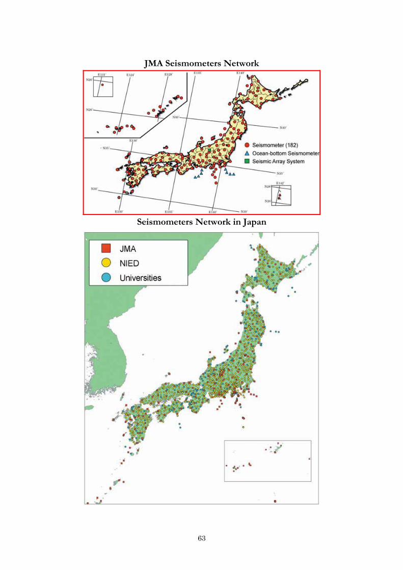
63
JMA Seismometers Network
Seismometers Network in Japan

64
Column: Magnitude and Seismic Intensity "Magnitude" is a numerical value which represents the scale of a fault slip
underground. When the seismic wave released from the fault reaches the land surface, we feel a ground motion. "Seismic intensity" represents the scale of the ground motion at the land surface.
Magnitude (Richte Scale) : Magnitude is an indicator of the scale of an earthquake and often represented as "M". M is calculated from the maximum amplitude of the seismic wave recorded by seismometers. One increase of M means that the energy of earthquake increases thirtyfold.
Seismic Intensity : Seismic Intensity is an indicator of the scale of the ground motion caused by an earthquake and measured by seismic intensity meters. The seismic intensity (JMA scale) is divided into 10 scales, namely, 7, 6 upper, 6 lower, 5 upper, 5 lower, 4, 3, 2, 1 and 0 in order from the strongest to the weakest. People feel a shake in greater than scale 1, buildings are damaged in 5 upper and serious damage is caused in 6 upper.
5.2.8. Seismic Intensity Network. JMA installed about 600 seismic intensity meters throughout the country. In addition, JMA collects seismic intensity data from other 3,300 stations operated by local governments and the National Research Institute for Earth Science and Disaster Prevention (NIED). When an earthquake occurs, JMA promptly issues seismic intensity information based on the data obtained at those stations. The seismic intensity information is used by disaster management authorities as reference for their initial actions in emergency.
Seismic Intensity Meters used for Information issued by JMA

65
Earthquake Monitoring System in and around Tokai region. Various kinds of instruments such as seismometers, strainmeters and GPS are installed in and around the Tokai region. (See the figure below.) These observational data are continuously transmitted to the JMA Headquarters. These observations are maintained under joint cooperation effort with the Geographical Survey Institute, Japan Coast Guard, the University of Tokyo, Nagoya University, National Research Institute for Earth-Science and Disaster Prevention, Advanced Industrial Science And Technology, Shizuoka Prefecture and others. What is the strainmeter? The strainmeter has an important role to detect the Pre-slip prior to the Tokai Earthquake. The strainmeter measures very minute expansion or contraction of underground rock. Its cylindrical sensor is settled at the bottom of borehole whose diameter is about 15cm and depth is several hundred meters. The sensor detects its deformation by pressure or tension surrounding rocks with very high precision. The strainmeter can measure one billionth of relative JMA uses two types of strainmeter. One is Volume Strainmeter, which measures amount of expansion or contraction of volume, and the other is Multi Components Linear Strainmeter, which measures not only amount but also direction of expansion or contraction of surrounding rock. The data observed by these strainmeters are used for information about Tokai Earthquake. Mechanism of Strainmeter
Strainmeter is an instrument to detect the condition of surrounding rock by measuring precise deformation of the sensor.

66
Observation Network for Prediction of Tokai Earthquake
5.2.9. Basic Knowledge on Earthquake Structure of the Earth. The earth consists of crust, mantle and core. The crust and mantle are solid but in the long term perspective, they flow slowly. In the earth's interior, the temperature rises higher as getting closer to the center of the sphere and convection are taking place. Plates (composed of crust and upper mantle) are produced on surface of the earth where internal mass is upwelling. The plates diverge and drift on the surface very slowly, a few centimeters per year. At the end, the plates subduct into the mantle and disappear. The earth is covered by such ten and several plates. Structure of the Earth's Interior

67
Crustal Movement
Mechanism of Earthquake. Each plate on the earth's surface drifts to different directions. Therefore, at the plate boundaries, they are pushing or rubbing each other or subducting beneath another. Around Japan, the oceanic plates are subducting beneath the continental plates and large earthquakes often occur. In addition, the strain energy is stored in the continental plates and this is supposed to cause shallow earthquakes in land areas.

68
Large Earthquakes around Trench (source: Headquarters for Earthquake Research Promotion)
Oceanic plate subducts beneath continental
plate.
Continental plate is dragged down and strain
energy is stored.
When the strain exceeds the certain level,
continental plate jumps up and earthquake and
tsunami are generated.
return to the beginning
Seismic Activity in the World. Most of the earthquakes occur along the plate boundaries where crustal plates are produced (ridge or rift valley), subducting beneath others (trench) or rubbing against each other. Around the trenches the Chilean Earthquake occurred in 1960, which is the largest in the 20th century, and the off Sumatra Island Earthquake occured in 2004, which caused the unprecedented Indian Ocean wide tsunami disasters. Seismic Activity in Japan. Since Japan is located on the plate boundary where two oceanic plates (Pacific Plate and Philippine Plate) are subducting beneath two continental plates (Eurasian Plate and North American Plate), Japan is one of the most
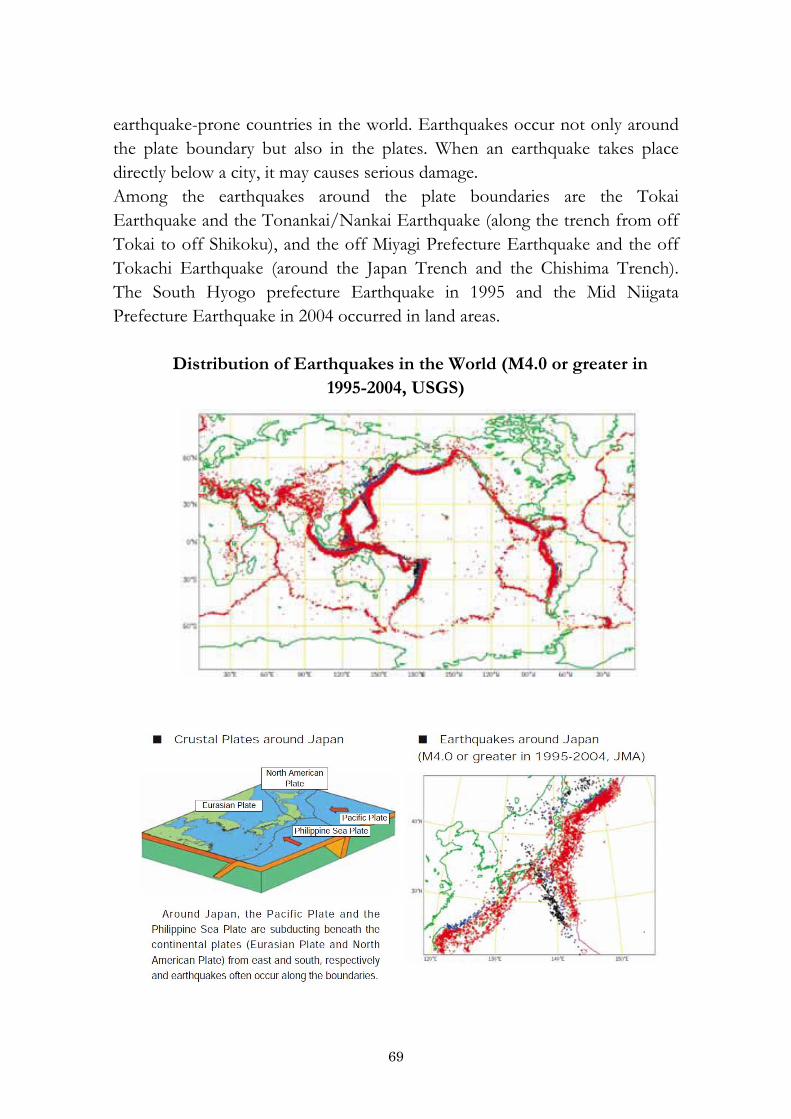
69
earthquake-prone countries in the world. Earthquakes occur not only around the plate boundary but also in the plates. When an earthquake takes place directly below a city, it may causes serious damage. Among the earthquakes around the plate boundaries are the Tokai Earthquake and the Tonankai/Nankai Earthquake (along the trench from off Tokai to off Shikoku), and the off Miyagi Prefecture Earthquake and the off Tokachi Earthquake (around the Japan Trench and the Chishima Trench). The South Hyogo prefecture Earthquake in 1995 and the Mid Niigata Prefecture Earthquake in 2004 occurred in land areas.
Distribution of Earthquakes in the World (M4.0 or greater in
1995-2004, USGS)

70
VI. Conclusion. Over the last decade, emergencies caused by natural and man-made disasters have become more frequent and the risk of emergencies characterized by different genesis has increased. As a result of various types of natural disasters (earthquakes, tsunamis, hurricanes, tornados, floods, mud-flows, landslides, avalanches and volcanic eruptions) more than 350 thousand people have already died in the XXIst century. Unfortunately this number of victims to natural disasters keeps growing every year. It should be noted that alongside with the unique geographic position of Central Asia the region is highly prone to natural disasters (earthquakes, landslides, mudflows, floods, droughts, etc). The complicated environmental setting existing in the region and other countries of the world is primarily associated with natural and anthropogenic factors. Therefore it is imperative that new ways to address the problem are developed including effective interaction with the world community. Natural disasters represent potential hazard on the territory of Uzbekistan too: earthquakes, landslides, mudflows, floods and droughts. Earthquakes can be extensive and affect large areas. For instance, strong earthquakes that occurred during the XXth century in Andizhan (1902), Tashkent (1946 and 1966) and Gazli (1976 and 1984) resulted in huge economic losses and caused human casualties. Reduction of losses resulting from natural disasters is one of the most urgent problems which affect various aspects of human activities (economic, social and cultural). As you know Japan is a highly developed country in the world. But every year in Japan is facing natural disasters such as earthquakes, tsunamis, floods and volcanic eruptions, which cause huge damage to the economy and the loss of lives. The use of modern technology and having a great experience on the prevention of natural disasters and ensure the safety of the residents of leader considers one of the countries in the world. Especially for monitoring earthquakes, landslides, floods and the construction of protective structures in mountain and foothill areas. After the Great Hanshin-Awaji earthquake, the Japanese Government has paid special attention to against natural disasters. During the 12 years, the Government of Japan established a unique system of monitoring earthquakes, landslides, floods, weather, tsunami, etc. and also an Early Warning of earthquakes, tsunamis, floods. The Early Warning System was launched in

71
2007. And also I learned that such a system exists only in four countries, China, Mexico, USA and Japan. Disaster Management System of Japan and Uzbekistan is very different, as if the natural disaster control the Japanese Meteorological Agency, and in Uzbekistan, Weather, Floods, Mudslides - controls the Meteorological Service of the Cabinet of Ministers, The Earthquake - Institute Seismological of the Academy of Science and Dangerous Geological Processes of the State Service on Monitoring Dangerous Geological Processes in the system Goscomgeology. I think that in the future improvement of the Disaster Management System in Uzbekistan, the Japanese’s Disaster Management System will be an example for Uzbekistan. Recommendation Experience and knowledge of Japan to reduce natural disasters and cooperation with the ADRC, Goscomgeology would like to implement the following in order to decrease the damage caused by landslide and earthquake processes, well-timed warning about the hazard sources, monitoring over their development and warning about the threat of dangerous geological processes and to increase the safety of residency and economic activity in mountain regions in Uzbekistan:
Improve the system of monitoring dangerous geological processes; Establish a unified interconnected system of remote, ground and
underground types of observations dangerous geological processes; Open a new scientific research direction "Influences of the earthquake on
dangerous geological processes" Create a unified database of hazardous natural processes (floods,
earthquakes, droughts, landslides etc.); Create a monitoring center of the earthquake in Tashkent. Create an Earthquake Alert System via mobile phones. Make a map of natural hazards caused by earthquakes, melting snow and
heavy rain by region of the republic. Establish a system of public notification of the impending threat in the
form of a siren or light signals.