Disaster mitigation strategies for adobe houses: A case ...
22
1st International Conference on Advances in Engineering & Technology (ICAET 2018), Faculty of Engineering & Architecture, BUITEMS Quetta, Pakistan 1 Disaster mitigation strategies for adobe houses: A case study of District Awaran, Balochistan, Pakistan Mamoon U R Mengal, Waqas A Mahar Department of Architecture, Balochistan University of Information Technology, Engineering & Management Sciences (BUITEMS) Quetta. e-mail: [email protected], [email protected], Abstract Every year disasters affect hundreds of millions of people globally causing damage that can take years to recover from. The process of rebuilding and re-establishing is vitally important to the successful continuation of life, industry and growth of affected societies and communities. Besides human casualties one of the most visible and striking effects of any major disaster is the destruction of houses. Construction of houses will be a major activity in the reconstruction phase of a disaster. The impact of disasters caused by natural hazards such as earthquakes can have serious consequences. Vulnerable populations are faced with unforeseen hardships, misery, and death if their houses and buildings collapse, and supporting infrastructure is severely damaged. Awaran District, Balochistan is one the least developed areas of Pakistan with very low Human development index (HDI). In 2013, an earthquake of Mw 7.7 occurred in the region, causing damage to the houses and human lives. The study covers the findings of the field survey for the damages occurred to the adobe houses in Awaran due to earthquake and analyse the causes of failure of the structures. It further suggests the design strategies and measures for the mitigation and prevention against these damages in order to decrease the loss to housing stock and lower the risks to human life due to failure of structures during earthquake. Keywords: field survey, earthquake, adobe houses, disasters, design strategies, Awaran 1. Introduction The natural disasters such as earthquake can have very serious consequences. It is a major disaster responsible for the vast loss of infrastructure and human lives (Mahmood, et al., 2017). The vulnerable populations may face unexpected hardships, misery, and death if the houses or building collapse and the supporting infrastructure is severely damaged. The rehabilitation and redevelopment work efforts would face several challenges since the strategic infrastructure get damaged or destroyed caused by the earthquake. The areas and regions may face economic crisis due to the loss of infrastructure which may lead to the poverty in the area. Many unfortunate people will face social setbacks until the worst outcomes of the disasters can be addressed. Th study focuses on the identification of the damages caused to adobe structures due to earthquake and suggest preventive measures for adobe structures to sustain during earthquakes. At first the existing construction practices for adobe structures in Awaran are analysed, then the damages occurred due to earthquake are identified and lastly the cost-efficient solutions are proposed by using locally available materials with minimum training to improve the skills of local artisans and residents. This paper provides the introduction and the context including the study area and Awaran earthquake, then an overview of the field survey is given which includes the methodology used for the survey and data collection. The materials and methods used for the construction are discussed and the causes of
Transcript of Disaster mitigation strategies for adobe houses: A case ...

1st International Conference on Advances in Engineering & Technology (ICAET 2018),
Faculty of Engineering & Architecture, BUITEMS Quetta, Pakistan
1
Disaster mitigation strategies for adobe houses: A case study
of District Awaran, Balochistan, Pakistan
Mamoon U R Mengal, Waqas A Mahar
Department of Architecture, Balochistan University of Information Technology,
Engineering & Management Sciences (BUITEMS) Quetta.
e-mail: [email protected], [email protected],
Abstract Every year disasters affect hundreds of millions of people globally causing damage that can
take years to recover from. The process of rebuilding and re-establishing is vitally important to
the successful continuation of life, industry and growth of affected societies and communities.
Besides human casualties one of the most visible and striking effects of any major disaster is
the destruction of houses. Construction of houses will be a major activity in the reconstruction
phase of a disaster. The impact of disasters caused by natural hazards such as earthquakes can
have serious consequences. Vulnerable populations are faced with unforeseen hardships,
misery, and death if their houses and buildings collapse, and supporting infrastructure is
severely damaged. Awaran District, Balochistan is one the least developed areas of Pakistan
with very low Human development index (HDI). In 2013, an earthquake of Mw 7.7 occurred in
the region, causing damage to the houses and human lives. The study covers the findings of the
field survey for the damages occurred to the adobe houses in Awaran due to earthquake and
analyse the causes of failure of the structures. It further suggests the design strategies and
measures for the mitigation and prevention against these damages in order to decrease the loss
to housing stock and lower the risks to human life due to failure of structures during
earthquake.
Keywords: field survey, earthquake, adobe houses, disasters, design strategies, Awaran
1. Introduction
The natural disasters such as earthquake can have very serious consequences. It is a major disaster
responsible for the vast loss of infrastructure and human lives (Mahmood, et al., 2017). The vulnerable
populations may face unexpected hardships, misery, and death if the houses or building collapse and
the supporting infrastructure is severely damaged. The rehabilitation and redevelopment work efforts
would face several challenges since the strategic infrastructure get damaged or destroyed caused by the
earthquake. The areas and regions may face economic crisis due to the loss of infrastructure which
may lead to the poverty in the area. Many unfortunate people will face social setbacks until the worst
outcomes of the disasters can be addressed.
Th study focuses on the identification of the damages caused to adobe structures due to earthquake and
suggest preventive measures for adobe structures to sustain during earthquakes. At first the existing
construction practices for adobe structures in Awaran are analysed, then the damages occurred due to
earthquake are identified and lastly the cost-efficient solutions are proposed by using locally available
materials with minimum training to improve the skills of local artisans and residents. This paper
provides the introduction and the context including the study area and Awaran earthquake, then an
overview of the field survey is given which includes the methodology used for the survey and data
collection. The materials and methods used for the construction are discussed and the causes of

1st International Conference on Advances in Engineering & Technology (ICAET 2018),
Faculty of Engineering & Architecture, BUITEMS Quetta, Pakistan
2
damages are identified, then disaster mitigation strategies for adobe houses are proposed based on
literature and practical implications.
1.1 Introduction to study area
The selected area of study is Awaran District located in the South of Balochistan province, Pakistan.
Awaran got the status of a district in 1992, previously it was a sub-division of Khuzdar District (PBS,
1998). Awaran is one of the least developed and considered the poorest district in Balochistan
province (PDI, 2007). Awaran is bordered by Kharan to its North-West, Khuzdar to its North-East,
Lasbela to its East and South, Panjgur and Kech to its West and Gwadar to its South (Figure 1). The
geographical area of Awaran is 29,510 km2 (P&D, 2011). It is sparsely populated and according to
Population and Housing Census 2017, the total population of Awaran district was 122,011 with 18,172
households (PBS, 2017). In 1998, there were only 338 (1.5%) Pucca houses in Awaran out 21735
whereas only 91 (0.42%) housing units had electricity. The development indicators of Awaran are low
in all sectors including, food, health, economy and specially security (Ahmed, 2017). Awaran district
and its nearly areas in the region are affected by insurgency and conflict since many years (PIPS,
2010). Army contingents and para military troops are deployed to maintain peace and prevent the
conflict (Nation, 2015). The climate of Awaran is hot in summer (with cool nights) and moderately
cold in winter (P&D, 2011).
Figure 1. Location of Awaran in Balochistan province
(Note: 4 newly created districts are not shown in the map)
1.2 Awaran Earthquake
Awaran District is also situated in earthquake zone and on 24th September 2013 an earth quake of Mw
7.7 hit the area (USGS, 2013a). An aftershock of Mw 6.8 took place on 28th September 2013 (USGS,
2013b) while the National Seismic Monitoring Centre of Pakistan considered it a new earthquake. The
earthquake affected more than 27,000 households or 138,372 people, and destroyed or damaged
19,688 houses, around 500 people died, and hundreds got injured (UNOCHA, 2013). The epicentre of
the earthquake was in north-northwest of Awaran at 66km. The loss of lives was not proportionate to
the magnitude of the earthquake since the time of earthquake was 16:30 in the afternoon, when most of
the people were out of their homes. The damage caused to the structures was, however, of the
unimaginable scale. Entire villages and neighbourhoods were turned into piles of debris.

1st International Conference on Advances in Engineering & Technology (ICAET 2018),
Faculty of Engineering & Architecture, BUITEMS Quetta, Pakistan
3
Figure 2. Earthquake epicentre along with fault line
Source: (Shah & Jin, 2018)
2. Awaran Field Survey by BUITEMS Team
In October 2013, the Heritage Foundation of Pakistan contacted Balochistan University of Information
Technology, Engineering & Management Sciences (BUITEMS) Quetta, seeking help in carrying out
the survey of the earthquake affected areas and then dissemination of knowledge and implementation
of the vernacular methodologies for safe and economic construction so that the damages may be
averted in case of a future similar disaster. A survey team was formed consisting 2 faculty members, 4
students and some local volunteers from Awaran district. The team surveyed earthquake affected areas
of Awaran District from 8-14 October 2013. The areas covered in this survey includes Nok Jo, Gajjar,
Jabry, Kullar, Malar, Mangoli, Gishkore and Dandaar.
Due to the difficult terrain, and lack of roads, it takes more time in Awaran district to move from one
village to another. It is also mentioned earlier that law & order situation in Awaran was unsatisfactory
and due to that access to some areas was restricted for safety reasons. Moreover, the BUITEMS survey
team had limited time and resources; in this situation it was not possible to carry out a comprehensive
survey of each home destroyed or damaged in the earthquake. Majority of the houses in a locality were
built using the identical construction techniques and materials and almost all houses shared the factors
that caused the damage. Considering all these factors the survey team carried out detailed survey of
two representative houses from each locality. The substantial amount of data was gathered from the
survey of 26 houses in total located at different villages, neighbourhoods, and localities of Awaran
district.
As discussed by (Mahar, 2012), two survey methods are usually used for the reporting of defects or
damages: i) Stock condition survey: this includes physical observation and questionnaire ii) day-to-day
survey. Stock condition survey method by using questionnaire and physical observation was adopted
for this study. A survey questionnaire was designed to record the data of damages and destruction, it
further includes the demographic information of the residents, and the materials and construction
techniques used in the houses. Since the survey team visited the affected areas, not only the scale and
magnitude of damage was realized, but also the causes of damage could be identified. The team also
focused on the assessment of locally available materials and construction techniques to identify any
shortcomings, which may be rectified to minimize the damage in case a similar disaster strikes again.

1st International Conference on Advances in Engineering & Technology (ICAET 2018),
Faculty of Engineering & Architecture, BUITEMS Quetta, Pakistan
4
The team first arrived at Mangoli and it was then when they realized the scale of destruction. The
village of Mangoli was completely razed to the ground except a few adobe huts. The villagers were
using some of the tents provided by the earthquake relief as temporary shelters. They set up the tents
along with the remains of their houses. The destruction at Mangoli can be seen in figure 3, survey team
members are also busy in data collection.
Figure 3. Destruction at Mangoli
After the survey at Mangoli the team moved to Kullar town in Mashkay. The team was then split into
two groups. One group did the survey in the twin towns of Kullar and Gajjar whereas the other group
moved further north towards the villages of Nok Jo and Jabry. The twin towns of Kullar and Gajjar lie
on either bank of the ravine, locally known as ‘Kaur’. The town of Kullar is on the South-Eastern bank
of this ravine whereas Gajjar is on the North-Western bank. There is a marked difference in the
devastation caused by the earthquake in Kullar and Gajjar. While the town of Gajjar has been
completed destroyed as shown in figure 4(a), Kullar has only been partially damaged as shown in
figure 4(b). This trend can be found throughout the district. The places that are on the North-Western
side of the ravine (presumably there is a fault underneath) have been more damaged compared to those
on the South-Eastern side, which includes Awaran town, the district headquarter of Awaran.
Figure 4(a). Damages at Gajjar town Figure 4(b). Houses standing at Kullar town
As mentioned before the second group moved to Nok Jo and Jabry, they planned to go up in north to
record all the damages caused by earthquake. After arriving at Jabry the group realised that this is the
last point where the earthquake affected the houses as the damages to houses at Jabry were rather little.
However, the scenario in Nok Jo was totally different, as shown in figure 5. The entire houses were
razed to the ground and only few straw huts survived the earthquake.

1st International Conference on Advances in Engineering & Technology (ICAET 2018),
Faculty of Engineering & Architecture, BUITEMS Quetta, Pakistan
5
Figure 5. Earthquake damages at Nok Jo
After completing survey at Kullar, Gajjar, Nok Jo and Jabry the team left to Awaran Tehsil. Here the
first village visited by the team was Malaar which was entirely destroyed except some straw huts
which withstand the earthquake. It was found that stone boulders were mainly used in Awaran Tehsil
compared to mud bricks which were commonly used in Mashkay. The houses made of stone boulders
not coped well with the earthquake which can be seen in figure 6. The team then continued the survey
further south in the villages of Gishkore and Dandaar.
Figure 6. Destruction at Malaar
(stone boulders used in wall construction can be seen in the picture)
The survey fulfilled the primary purpose of collecting information about the damages, and prevailing
construction materials and techniques used in the region. Based on the study and recorded observation
the team analysed the possible causes of the damages and destruction in the adobe structure and
proposed the best possible solutions by using traditional methods, maximizing the use of locally
available materials, and using vernacular architectural techniques. People around the world especially
living in rural areas of the developing countries often go for reinforced concrete structures in case of
earthquake mitigation. However, there are certain concerns that should be taken care of, such as,
availability of material, technical skills and labour, and the cost of construction or repair. We also
know that, the concrete as a building material has higher value of carbon foot print and high thermal
conductivity as compared to mud and bamboo which are locally available in abundance.

1st International Conference on Advances in Engineering & Technology (ICAET 2018),
Faculty of Engineering & Architecture, BUITEMS Quetta, Pakistan
6
3. Construction materials, methods, and techniques
3.1 Materials
Even the area is barren, and it receive very less rainfall, there is some vegetation in the region. The
plants and agricultural products grows in the area are also used for the construction of houses. Figure
7(a) shows a plant locally named as Pharha, is widely grown in this region and its leaves are used for
thatching purpose in adobe house, roofing in houses made from mud-stacks, mud-bricks and
sometimes even stone. The leaves of this plant are also used to make mats and other handicraft items,
the making and selling of which forms an integral part of the local economy. The survey team
observed the presence of large orchards of Date-Palm trees in the Mashkay area consisting the
settlements of Nok Jo, Kullar, Jabry, Mangoli and Gajjar etc. as shown in Figure 7(b), which apart
from being a very important export of the locality supporting the local economy, provides the bulk of
the material for roofing. Some vegetation in Mashkay is shown in figure 7(c). There are deposits of
alluvial soil brought along by the rainwater from the north, resulting in the abundance of mud
available to be used as a construction material. In south toward Awaran tehsil, the quantity of date
palms is less and area consist smaller bushy plants, Figure 7(c). The available mud for making bricks
is also less that is why stone boulders are mainly used in the south of Awaran district.
Figure 7(a). ‘Pharha or Peesh plant is found in abundance Figure 7(b). Date-Palm orchards in Mashkay
Figure 7(c). Thick vegetation of Kashum in Mashkay Tehsil
3.2 Planning & design of houses
There is not much variation in the planning of houses from south in Awaran tehsil to the north in
Mashkay tehsil. Many houses as per 1998 census consisted only one room, 78%. In the survey it was
observed that most of the houses consisted of 2-3 rooms located on the edge of the plot. Houses
usually do not have boundary wall. The toilet and kitchen are separated from the main unit, the kitchen
being right in front whereas the toilet being located on one side while taking care that it is away from
sight of somebody approaching the house. The bathrooms are normally attached to one of the bed

1st International Conference on Advances in Engineering & Technology (ICAET 2018),
Faculty of Engineering & Architecture, BUITEMS Quetta, Pakistan
7
rooms which was not the trend in the past, but it is now increasing. Some wealthy families have
bathrooms attached to every room. A plan sketched during the field survey is shown in Figure 8.
Figure 8. A sample plan of a house in Mashkay
3.3 Construction
3.3.1 Wall construction
Walls were constructed of mud stack in the northern parts of Awaran which changes to the south
where stone boulders are being used for the construction of walls. The use of mud- brick is generally
more common in the whole region. For mud walls, the wall thickness is constant as well, which was
18” (45.7 cm) for all the houses.
For mud stack walls, wheat husk and animal dung are usually mixed with the mud in order to
strengthen the mud, figure 9(a). The foundations are normally laid 1-2 ft. in the ground (30.4-61 cm)
with the same mud-stacks but slightly wider than the actual wall. No stiffeners are used anywhere in
the wall in horizontal as well as vertical directions. Wooden lintels are sometimes provided on the top
of windows and doors in isolation, which have little affect towards strengthening the wall. Whereas
the bricks are made from a mixture mainly consist of mud but, small stones with organic materials like
weeds and reeds are also used to strengthen the brick. The brick size was, 4”x6”x12” (10.1x15.2x30.4
cm) constant throughout the district. A steel mould is used for this purpose which is open from top and
bottom. Moulded bricks are left on the open ground to get dry. The foundations are normally laid 1-2
ft. (30.4-61 cm) in the ground constructed of the same bricks as used in the walls. Foundations with
stone boulders were also seen at some locations. No stiffeners are used in brick walls which is similar
to the mud stack walls, figure 9(b). Moreover, wooden lintels are also placed on top of the doors and
windows, which does not strengthen the walls.
The use of stone boulders for the construction of walls was mainly seen in the south, such as in
Gishkore and Dandaar areas. The stones were mainly round and of improper shapes or bounding,

1st International Conference on Advances in Engineering & Technology (ICAET 2018),
Faculty of Engineering & Architecture, BUITEMS Quetta, Pakistan
8
excessive mud plaster was used for the construction of such walls. The walls have the same width as
of other walls, i.e. 18” (45.7 cm) and constructed without using any stiffeners, figure 9(c).
Figure 9(a). Mud-stack walls Figure 9(b). Mud-brick walls
Figure 9(c). Stone boulder walls
3.3.2 Roof construction
The roof construction techniques do not vary much throughout the district. Mainly there were two
types of roof construction; the wealthy families used T-iron and girders (commonly known as Tier-
Gaarder) roofs in their houses while most of the houses used date palm branches laid over heavy
wooden joists.
Figure 10(a) shows the roof constructed of t-iron and girders which is also called tiled roof because of
the use of terracotta roof tiles. In this type of roof t-shaped steel sections are placed over the I-shaped
steel girders and terracotta tiles are placed on the T-shaped iron bars. The terracotta tile used for this
purpose was of the size 12”x12” (30.4x30.4 cm) with a thickness of 1.5” (3.8 cm). A plastic sheet is
usually placed on the top to insulate the roof against rainwater then the screed of mud mortar is spread

1st International Conference on Advances in Engineering & Technology (ICAET 2018),
Faculty of Engineering & Architecture, BUITEMS Quetta, Pakistan
9
on the roof to insulate it against the heat. This mud mortar may also include some organic materials for
bonding purpose.
Figure 10(a). T-Iron and girder roofs with terracotta tiles
Date palm roofs as shown in the figure 10(b) are very common in most of the houses, since the date
palm is locally available in the region. According to local tale, the date palm is termite proof if cut in
the winter season. The roof consists the joists made from date palm tree trunk. The use of steel girder
and telephone line poles was also seen in some houses. The joists or girders are placed directly on top
of the walls without using lintel band or ring beam. A net made of date palm branches is commonly
used on the top of joists or girders. A mat is placed on the date palm branches then a plastic sheet for
insulation against water. At the top, finally a layer of mud mortar is laid for the insulation against heat.
Figure 10(b). Roof made of Date-Palm joists and Date-Palm branches serving as purlins
4. Causes of damage
The factors responsible for the major damages occurred in the houses were identified by the survey
team and are discussed below:
4.1 Inappropriate brick making
The mud bricks made locally and used for the construction of houses were of improper shape and form
with round surfaces and uneven edges making it essential to use extra mortar during the construction
of walls, figure 11. The material mix used for the brick making was not up to the standard as it
contained boulders and organic materials, such as reed stalks etc.

1st International Conference on Advances in Engineering & Technology (ICAET 2018),
Faculty of Engineering & Architecture, BUITEMS Quetta, Pakistan
10
Figure 11: Bricks placed for drying
4.2 Improper brick bond
During the construction of a wall, the brick courses were placed without following any proper bond
pattern, see Figure 12. Some bricks were placed slanted while some were placed vertically. Whatever,
was the reasons for using bricks in such manner, it made the walls vulnerable to even a slight jolt.
Figure 12: A wall with the lack of bond
4.3 Weak corners
It was observed that in most of the construction, the corners were not strengthened and as a result they
gave in easily when the walls started shaking, as shown in Figure 13, the wall is damaged at the
corner.
Figure 13. Wall damaged due to weak corner

1st International Conference on Advances in Engineering & Technology (ICAET 2018),
Faculty of Engineering & Architecture, BUITEMS Quetta, Pakistan
11
4.4 Use of heavy girders
Heavy girders were used in majority of the houses without having any mechanism for the distribution
of loads, see figure 14. As a result, the concentrated load from the heavy girder was applied to only a
few bricks which failed easily. The heavy girders caused more structural damage and may also been
responsible for any loss of life that occurred.
Figure 14. Heavy girders caused damage
4.5 Lack of projections
The roofs were placed on the walls, as shown in Figure 15, such that there were no projections on any
side. As a result, when the walls even slightly moved, the roof came down pushing the walls further
while doing so. As a result, the entire houses collapsed.
Figure 15. Lack of projections
4.6 Pre-earthquake damages
Most of the mud and mud brick walls were already weakened by the rainwater mainly due to spouts
and not having the required projections to stop the rainwater penetration into the walls, as shown in
Figure 16. This had made the walls weak and thus vulnerable.

1st International Conference on Advances in Engineering & Technology (ICAET 2018),
Faculty of Engineering & Architecture, BUITEMS Quetta, Pakistan
12
Figure16. Damage caused by water spouts
5. Solutions and strategies
The use of mud for the construction is one of the old practice and the use of sundried bricks is traced
back to 8000 B.C. (Houben & Guillaud, 1994). Adobe houses are very common in many parts of the
world even in the most hazard-prone areas (Blondet, Garcia M., Brzev, & Rubinos, 2011).
Approximately, 3 billion people or 30%-50% of the global population lives or works in earthen
buildings (Rael, 2008). Around half of the population in developing countries and at least 20% of the
urban population, live in earthen dwellings (Houben & Guillaud, 1994). However, adobe construction
is mainly used in rural areas and houses are typical one story high. Adobe houses are low cost, locally
built by communities and can be constructed in less time. In many parts of the world the adobe houses
are constructed without specific design consideration which make them weak to the earthquake or
other disaster. By adopting some construction techniques, these houses can resist the earthquake
movements which would save the damages to property and humans lives during possible disasters.
Some disaster mitigation strategies and solutions for adobe houses are discussed here in order to
construct the adobe houses to withstand the earthquake disaster.
5.1 Brick making
It is necessary to make the brick of proper and even size. The soil should be first passed through the
sieve to separate the gravels and small stones before formation of the mix. The proper moulds should
be used to mould the bricks and then moulded bricks must be placed on even ground or surface to let it
dry, figure 17(a) and 17(b).
Figure 17(a) and 17(b). Brick making
5.2 Wall construction
Walls and roof are main components of a house and it is an important decision to make while
rebuilding the house that what kind of roof or walls would be safe. Most of the Awaran disaster
victims will probably need to rebuild spending as little as possible for materials. Trash and cement and
rebar may be luxuries they cannot afford. But some simple techniques and a few supplies can allow
them to rebuild with local earthen materials in a significantly stronger way. These simple techniques

1st International Conference on Advances in Engineering & Technology (ICAET 2018),
Faculty of Engineering & Architecture, BUITEMS Quetta, Pakistan
13
are important to reduce danger to adobe from earthquakes. Using a strong bond beam on top of the
walls, figure 18(a) and adding mesh-reinforced plaster to inner and outer walls that is tied together
through the walls can preserve a low-strength earthen building through an earthquake. Either wood or
bamboos can be used for a ring beam and must be overlapped and braced at corners. Opening like
doors and windows should be kept away from each other and the corners as shows in figure 18(b).
Figure 18(a). Bond beams on wall tops Figure 18(b). Doors & windows far from the corners
Source: (Shah S. , 2014) Source: (Shah S. , 2014)
Using long lintels on the doors and windows would provide better reinforcement, Figure 19(a). One of
the cheapest way to reinforce this type of wall against earthquakes is by adding piers or buttresses,
shown in the Figure 19(b). The mass of the corner structures helps to reduce the damage to walls.
Buttresses of same type must be used at all the corners and at the distance of every 5-6 m on long
straight walls. Piers or buttresses do not need to be vertical but can tapered or diagonal as the walls
rise.
Figure 19(a). Extra-long lintels Figure 19(b). Buttresses at wall corners
Source: (Shah S. , 2014) Source: (Shah S. , 2014)
Reinforced plaster should be used to save the adobe houses. The reinforcement can be done by using
small wooden poles, heavy mesh strips or a light layer of plastic mesh and the reinforcement should be
tied through the walls. An earthquake may destroy the plaster when mesh layers are attached through
the walls. But the cracking of plaster will allow more of the building walls to be preserved. And plaster
is easier to repair than the walls. If the wall is built on a sandbag base, light fishnet or bird netting can
be used to reinforce the walls. This will greatly cost much less than plastic geo-mesh or plastic barrier
fencing.

1st International Conference on Advances in Engineering & Technology (ICAET 2018),
Faculty of Engineering & Architecture, BUITEMS Quetta, Pakistan
14
Soil and its properties has great influence on the strength of the adobe houses. For this purpose, a soil
test or dry strength test must be done. Make five mud balls from the selected soil of 20 mm diameter.
Let them dry for 24h and then try to crush each ball between your thumb and forefinger. If you ae
unable to crush the balls, figure 20(a) then soil is appropriate for adobe construction and if one or more
balls can be crushed, figure 20(b) then soil has inappropriate contents of the clay and is not suitable for
building adobe houses.
Figure 20(a) and 20(b) Crushing of mud balls
Source: (Blondet, Garcia M., Brzev, & Rubinos, 2011)
As mentioned in section 4.2 that the improper brick bond was also a cause of damages. The bricks
should be properly bounded to strengthen the bond. The corner can be strengthened by using bamboos
as reinforcement on the corner which is shown in figure 21.
Figure 21. Corner strengthening using bamboos as reinforcement
Source: (HPF, 2013)
1st International Conference on Advances in Engineering & Technology (ICAET 2018),
Faculty of Engineering & Architecture, BUITEMS Quetta, Pakistan
15
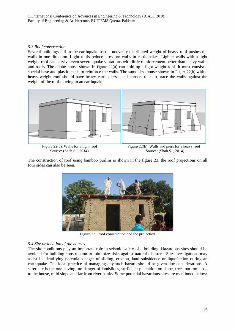
5.3 Roof construction
Several buildings fail in the earthquake as the unevenly distributed weight of heavy roof pushes the
walls in one direction. Light roofs reduce stress on walls in earthquakes. Lighter walls with a light
weight roof can survive even severe quake vibrations with little reinforcement better than heavy walls
and roofs. The adobe house shown in Figure 22(a) can hold up a light-weight roof. It must consist a
special base and plastic mesh to reinforce the walls. The same size house shown in Figure 22(b) with a
heavy-weight roof should have heavy earth piers at all corners to help brace the walls against the
weight of the roof moving in an earthquake.
Figure 22(a). Walls for a light roof Figure 22(b). Walls and piers for a heavy roof
Source: (Shah S. , 2014) Source: (Shah S. , 2014)
The construction of roof using bamboo purlins is shown in the figure 23, the roof projections on all
four sides can also be seen.
Figure 23. Roof construction and the projection
5.4 Site or location of the houses
The site conditions play an important role in seismic safety of a building. Hazardous sites should be
avoided for building construction to minimize risks against natural disasters. Site investigations may
assist in identifying potential danger of sliding, erosion, land subsidence or liquefaction during an
earthquake. The local practice of managing any such hazard should be given due considerations. A
safer site is the one having; no danger of landslides, sufficient plantation on slope, trees not too close
to the house, mild slope and far from river banks. Some potential hazardous sites are mentioned below:
1st International Conference on Advances in Engineering & Technology (ICAET 2018),
Faculty of Engineering & Architecture, BUITEMS Quetta, Pakistan
16
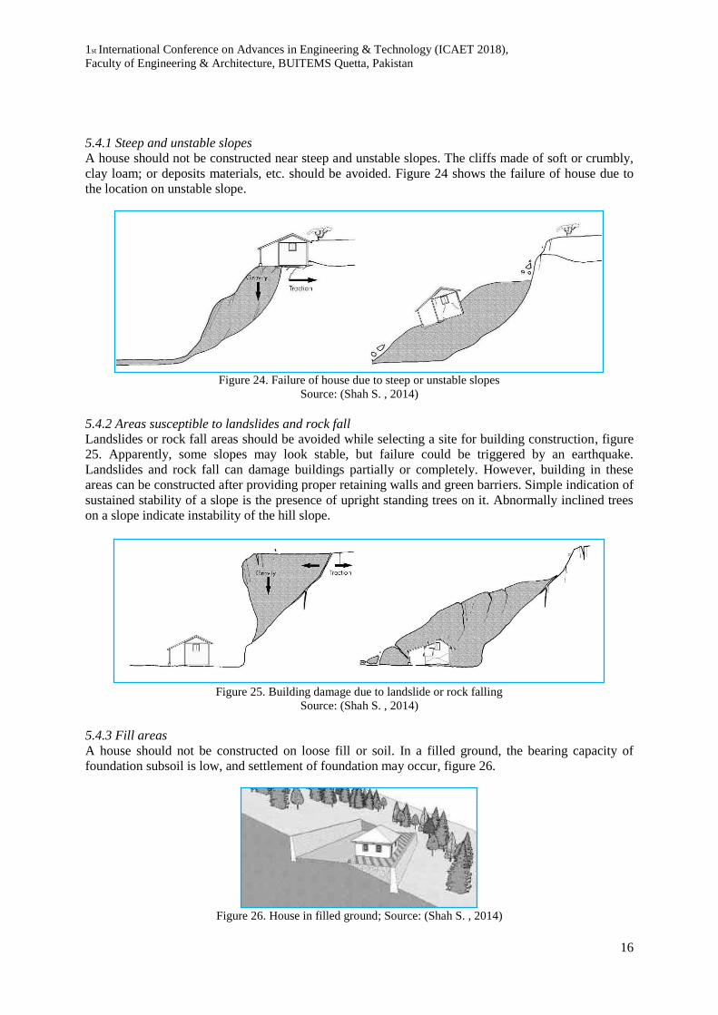
5.4.1 Steep and unstable slopes
A house should not be constructed near steep and unstable slopes. The cliffs made of soft or crumbly,
clay loam; or deposits materials, etc. should be avoided. Figure 24 shows the failure of house due to
the location on unstable slope.
Figure 24. Failure of house due to steep or unstable slopes
Source: (Shah S. , 2014)
5.4.2 Areas susceptible to landslides and rock fall
Landslides or rock fall areas should be avoided while selecting a site for building construction, figure
25. Apparently, some slopes may look stable, but failure could be triggered by an earthquake.
Landslides and rock fall can damage buildings partially or completely. However, building in these
areas can be constructed after providing proper retaining walls and green barriers. Simple indication of
sustained stability of a slope is the presence of upright standing trees on it. Abnormally inclined trees
on a slope indicate instability of the hill slope.
Figure 25. Building damage due to landslide or rock falling
Source: (Shah S. , 2014)
5.4.3 Fill areas
A house should not be constructed on loose fill or soil. In a filled ground, the bearing capacity of
foundation subsoil is low, and settlement of foundation may occur, figure 26.
Figure 26. House in filled ground; Source: (Shah S. , 2014)

1st International Conference on Advances in Engineering & Technology (ICAET 2018),
Faculty of Engineering & Architecture, BUITEMS Quetta, Pakistan
17
5.4.4 River banks
A house should be far enough from the river to avoid flash flood and earthquake damage, figure 27.
Figure 27. House near river banks
Source: (Shah S. , 2014)
5.4.5 Geological fault and ruptured areas
Geological fault and ruptured areas are usually visible, permanent, deep, and active. These are not
suitable for the construction of a building, figure 28. A house may preferably be built at a distance of
at least 250 m from such fault lines.
Figure 28. House near geological fault areas.
Source: (Shah S. , 2014)
5.4.6 Forest and trees
The forests are useful to stop landslides, but buildings should not be constructed close to any big tree,
as there might be a possibility of falling of the trees during earthquake. The distance between tree and
house should preferably be at least equal to the height of tree or house, whichever is greater, figure 29.
Figure 29. Distance of house from the tree
Source: (Shah S. , 2014)
5.4.7 Distance from a building
A building should not be constructed close to another building: there might be a possibility of falling
of building during earthquake. The distance between two houses should be at least equal to the height
of house, figures 30(a) and 30(b).
Figure 30(a). Not recommended distance between houses Figure 30(b). Recommended distance btw. houses
Source: (Shah S. , 2014)

1st International Conference on Advances in Engineering & Technology (ICAET 2018),
Faculty of Engineering & Architecture, BUITEMS Quetta, Pakistan
18
5.5 Design and planning
The shape, size and layout of the building is important for its seismic safety. Constructions with
asymmetrical plan and elevation are more vulnerable to earthquake than those having symmetrical
plans elevations.
5.5.1 Regular shape
Regular shaped buildings like square, rectangular, or circular resist the earthquakes more effectively as
compared to irregular buildings and are therefore preferable in earthquake prone areas. During the
earthquake movements the corners of nonuniform buildings are stressed more and may be damaged.
Complex shaped buildings, shall therefore be made simple by providing gaps at appropriate locations.
Some complex shapes and their simplified solutions are shown in figure 31.
Figure 31. Building shapes
Source: (Shah S. , 2014)
5.5.2 Short walls
In long and narrow buildings, longer wall is weak against earthquake forces and can easily fell during
an earthquake. Therefore, if long and narrow buildings are constructed, they should be divided into
two or more blocks with sufficient gap between them. The individual length of separate blocks should
not exceed three times its width. The foundation of these blocks may be connected to each other and
separation can be made only in the superstructure. The other alternatives include provision of cross
walls and buttresses as shown in figure 32.
Not recommended Recommended
Figure 32. Short and long wall lengths
Source: (Shah S. , 2014)
5.5.3 Box effect
One of the essential principles of earthquake-resistant construction is to use a compact, box type
layout. Furthermore, all the components of the building such as walls, floor, and roof structure, should
be well tied up with each other, so the building could act as a box during earthquake vibration. The

1st International Conference on Advances in Engineering & Technology (ICAET 2018),
Faculty of Engineering & Architecture, BUITEMS Quetta, Pakistan
19
maximum length of wall between cross walls shall preferably be limited to 15 ft. (4.5 m) for an
effective box action, figures 33(a) and 33(b)
Figures 33(a) and 33(b). Box effect
5.5.4 Foundation
Foundation is the part of the building below the ground level. The purpose of the foundations is to
transfer the load of the construction to the ground. The weight of the structure must be suited to the
load capacity of the ground which in turn shall be stable. The structure must also be correctly joined
and anchored to the foundations. Generally, stepped strip footing should be adopted for load bearing
wall construction. The width of foundation should be sufficient so that soil is able to bear the weight of
the building without excessive settlement. If the foundation soil is soft, the width of foundation should
be more. Similarly, if the building weight is more, the foundation should have a greater width. A
minimum width of 2.5 ft. (76.2 cm) is suggested for single story construction.
Mud or mud bricks are not strong enough to resist earthquake forces at the foundation level. It is
recommended that the foundation should be preferably built by using dressed stones, burnt clay bricks
or concrete blocks. A 3.5 ft. (7.6-15.2 cm) thick pad of lean concrete shall be provided under the
foundation. The concrete mix proportions for this pad shall be 1:4:8 (one-part cement, four parts sands
and eight parts crushed aggregates). The depth of foundation below existing ground level should be at
least 3 ft. (91.5 cm) for soft soil and for rocky ground the depth of foundation may be reduced to about
1.5 ft. (45.7 cm).
5.5.5 Plinth construction
The plinth masonry should preferably be constructed using stone or burnt bricks laid in cement mortar.
Cement mortar or lime mortar is stronger than mud mortar in binding the stones or bricks in the wall
together to resist earthquake forces. The height of the plinth should be above the flood water line or a
minimum of 1 ft. (30.4 cm) above ground level. Wherever possible the height of plinth shall not be
more than 2.5 ft. (76.2 cm). Where higher plinths are required the thickness of walls below plinth shall
be increased. A details of plinth protection is shown in the figure 34.
Figure 34. Detail of plinth protection

1st International Conference on Advances in Engineering & Technology (ICAET 2018),
Faculty of Engineering & Architecture, BUITEMS Quetta, Pakistan
20
5.5.6 Waterproofing and drainage
As water makes the foundation soil weak. In an area that experiences rainfall or snowfall, it is
recommended to use a waterproofing layer at the plinth level before starting the construction of wall
above the plinth and provide an apron and drain around the house to prevent runoff water that might
wet walls or enter the foundation. In 2007, Awaran was highly affected by flooding which caused 20
deaths and more than 1800 houses were entirely collapsed (PDI, 2007). Figure 35 shows the effect of
plinth decay due to water.
Figure 35. Plinth decay
6. Conclusion
It can be concluded that the large devastation during Awaran earthquake was caused due to the
prevailing improper construction techniques and by using materials which were not suitable, such as
using heavy girders in roofs. The study explains how an adobe house can be built with proper design
and construction techniques and by using efficient locally available materials which will help the
structures to withstand the unexpected event of earthquake. By using these techniques, we ca not only
save the damage and loss to property but can also save human lives which are usually lost during
disasters. The suggested design and construction techniques can easily be implemented at local level
by proving proper training and knowledge to local artisans and labours who are associated with
building construction.
7. Acknowledgement
The authors are thankful to all members of BUITEMS survey team, and the residents of Awaran for
their cooperation. The support of Heritage Foundation of Pakistan, BUITEMS university and the
efforts and work done by Prof. Dr. Ehsan Ullah Kakar, Dr. Gul Ahmed Jokhio, Ar. Yasmeen Gul and
Ar. Shehroze Shah at various stages of this survey is highly appreciated.

1st International Conference on Advances in Engineering & Technology (ICAET 2018),
Faculty of Engineering & Architecture, BUITEMS Quetta, Pakistan
21
References
Ahmed, N. (2017). Housing reconstruction in a conflict zone: lessons learned from Awaran District in
Balochistan, Pakistan. Planning Malaysia: Journal of the Malaysian Institute of Planners, Vol.
15(Issue. 3), pp. 39-50.
Blondet, M., Garcia M., G., Brzev, S., & Rubinos, A. (2011). Earthquake resistant construction of
adobe houses. EERI/IAEE World Housing Encyclopedia.
Houben, H., & Guillaud, H. (1994). Earth construction - A comprehensive guide. ITDG Publishing,
London, United Kingdom.
HPF. (2013). Awaran Earthquake 2013: Seismic Resistant Vernacular Construction. Heritage
Foundation of Pakistan.
Mahar, W. A. (2012). Defects on building facades in Desa Bakti employee housing, Universiti
Teknologi Malaysia, Skudai, Johor, Malysia. Master Thesis M.Sc. (Planning-Housing),
Faculty of Built Environment, Universiti Teknologi Malaysia.
Mahmood, I., Iqbal, M., Mughal, M., Shahzad, M., Tariq, S., & Kalim, U. (2017). An investigation of
2013 Mw 7.7 Awaran Earthquake, Pakistan. International Letters of Natural Sciences, Vol. 61,
pp. 36-42.
Nation, T. (2015, March 25th). Six suspected insurgents killed in Awaran in Mashkhay- one soldier
died.
P&D. (2011). Awaran: District Development Profile. Planning & Development Department,
Government of Balochistan.
PBS. (1998). Population & Housing Census 1998. Pakistan Bureau of Statistics (PBS), Government of
Pakistan.
PBS. (2017). Population & Housing Census 2017. Pakistan Bureau of Statistics (PBS), Government of
Pakistan.
PDI. (2007). Awaran District Balochistan Flood Assessment. Participatory Development Initiatives
(PDI), Khuzdar, Pakistan.
PIPS. (2010). Conflict and insecurity in Balochistan: Assessing strategic policy options for place and
security, Final report. Pakistan Institute of Peace Studies (PIPS).
Rael, R. (2008). Earth Architecture. Princeton Architectural Press, New York, NY.
Shah, M., & Jin, S. (2018). Pre-seismic ionospheric anomalies of the 2013 Mw = 7.7 Pakistan
earthquake from GPS and COSMIC observations. Geodesy and Geodynamics, Vol. 1(Issue.
10).
Shah, S. (2014). Post Disaster Housing (Shelter for the earthquake affectees of Awaran). Bachelor of
Architecture Thesis, Department of Architecture, BUITEMS Quetta, Pakistan.

1st International Conference on Advances in Engineering & Technology (ICAET 2018),
Faculty of Engineering & Architecture, BUITEMS Quetta, Pakistan
22
United States Geological Survey. (2013a). Retrieved March 21st, 2018, from
https://earthquake.usgs.gov/earthquakes/eventpage/usb000jyiv#executive
United States Geological Survey. (2013b). Retrieved March 22nd, 2018, from
https://earthquake.usgs.gov/earthquakes/eventpage/usb000k1gb#executive
UNOCHA. (2013). Balochistan Earthquake 2013: Findings and Strategies. United Nations Office for
the Coordination of Human Affairs.