Directorade of Geociencies -...
16
Directorade of Geociencies Country Report of Brazil United Nations Committee of Experts on Global Geospatial Information Management (UN-GGIM) Fourth session New York, August 6-8, 2014
Transcript of Directorade of Geociencies -...

Directorade of Geociencies
Country Report of Brazil
United Nations Committee of Experts on Global Geospatial Information Management (UN-GGIM)
Fourth session New York, August 6-8, 2014
Country Report of Brazil – GGIM/Fourth session /New York, August 6-8, 2014
Country Report of Brazil
Brazil is a country of continental dimensions with over 8,500,000 km² of land area, varied geomorphological and environmental characteristics, and around 3,600,000 km² of sea area, which houses an enormous wealth of natural resources and biodiversity. Brazil currently has more than 200 million inhabitants. In the economic field, in recent years, Brazil has registered a growth of new jobs, rescuing millions of Brazilians out of poverty, and including many others in an emerging middle class. The Brazilian economic growth plan has been generating substantive investments in infrastructure related to construction, rehabilitation and modernization of ports, highways, airports, dams, water supply systems, irrigation systems, waterways, railways and many other essential investments. The growth of the Brazilian economy - increased production, employment generation and integrated development - depends crucially on these investments. By the nature of the investments and projects underway in the country, Brazil`s growth agenda has been demanding the expansion of our ability to efficiently produce, manage, disseminate and utilize geospatial information. This is certainly an essential condition for the state to promote spatial planning, to better manage large national projects and to integrate its policies with private business strategies in various sectors of the economy. In this context, we report Brazil`s developments with respect to geospatial information in various areas of expertise.
1) Brazil’s National Geoinformation Policy
The development of geotechnologies, the evolution of geospatial information and spatial data infrastructure (SDI) require studies on policies aimed at managing geospatial information, which must be linked with other institutional policies. In Brazil, the process of building the National Spatial Data Infrastructure (NSDI) was organized according to a plan of action based on the concept of Warnest (2005) on data, people, institutional issues, technology, norms and standards.In discussing the institutional component, it is clear that it includes policy, legislation and coordination issues.(WARNEST, 2005). Political and legal issues are addressed to ensure the effective management of risk associated with the use of spatial information, and also for the purpose of detailing the terms and conditions for its use (THOMPSON; WARNEST; CHIPCHASE, 2003, apud PAIXÃO, NICHOLS, COLEMAN, 2008). All this reference demonstrates the need to establish a National Geoinformation Policy, which has various tools, especially the NSDI. In Brazil, the first legal framework of the National Cartographic System (SCN) was Decree No. 9,210 (29 April 1946), with the aim of setting regulations for standardizing the Brazilian Cartography. It was followed by Decree-Laws No. 200 and No. 243 (28 February 1967). DL No. 243 sets the guidelines and bases of Brazilian cartography in order to meet the "demands of economic and social development of the country and National Security".This Decree-Law, currently in force, is the main legal instrument of national cartography that, along with two others – Law No.5878 of 1973 and Law No. 6183 of 1974 –,
Country Report of Brazil – GGIM/Fourth session /New York, August 6-8, 2014
regulate the actions of the Brazilian Institute of Geography and Statistics (IBGE) in conducting and implementingthe national statistical and cartographic systems. Organizationally, the SCN is under the Ministry of Planning, Budget and Management (MP), which is assisted by the National Commission of Cartography (CONCAR) in the coordination of SCN.CONCAR is a consultative and deliberative body within the MP.It currently consists of representatives of government (federal and state levels) and a private association of aerial survey companies. It discusses various issues including cartographic standards and specifications. Since 2005, CONCAR has been aligning its strategic plan with the new concepts of cartography. It defines the vision for the future as “CONCAR – organization recognized by society and able to ensure a National Cartographic System of excellence that leads to the timeliness and completeness of the National Geospatial Data Infrastructure.” In 2008, Presidential Decree No. 6.666/2008 established the National Spatial Data Infrastructure (NSDI) aimed at strengthening the regulation and coordination roles of the State, particularly at the federal level, with progressive decentralization to the state and municipal levels.INDE provides broad and shared access to geospatial information, with guaranteed interoperability, improving aspects of planning, knowledge of the territory and territorial planning with citizenship assurance. In 2008, Presidential Decree No. 6.666/2008 established the National Spatial Data Infrastructure (NSDI) aimed at strengthening the regulation and coordination roles of the State, particularly at the federal level, with progressive decentralization to the state and municipal levels.INDE provides broad and shared access to geospatial information, with guaranteed interoperability, improving aspects of planning, knowledge of the territory and territorial planning with citizenship assurance. INDE has promoted intense changes in work processes with technical areas of cartography, digital mapping and their processing or geoprocessment.Among the main changes, the NSDI clarified that the traditional cartography provided for the existing legal framework was outdated in relation to technological and conceptual progresses.Mapping has become an element of geospatial data and geoinformation. Brazil needed to create a policy focused on geoinformation, considering the new conceptual and structural paradigm represented by the NSDI.In this sense, CONCAR, chaired by the MP`s Department of Planning and Investment (SPI), has broadened the discussion forums on the management of geoinformation in Brazil with the creation of the Intergovernmental Forum of GeoinformationManagers (FIGG) and with the conduction of two INDE/Academy Workshops in an attempt to create a permanent network of discussions between CONCAR, geoinformationmanagers and the academia. It was precisely in the expansion of the discussions of CONCAR at these various forums that the proposal to discuss a National Geoinformation Policy, preliminarily named PNGeo, emerged.The PNGeo shall be a clear reference to maximize the use of geospatial information, structured according to its fundamentals, objectives, guidelines and tools.In addition,it shall contain the concepts, actors, standardization and recommendations for society and the state to take ownership and debate how to use and share geoinformation. In this construction process, the plenary of the 3rd FIGG approved the creation of an executive committee made up of two groups:a writing one and a revising one.This committee will draft a National Geoinformation Policy.The following issues are being discussed:construction of collaborative geoinformation, definition of official cartography and who are the domestic producers, authorship, intellectual property and licensing of geoinformation,financing models forgeoinformationprojects, policy framework that maximizes the use of geographic information, among others.. The proposal of a PNGeo is forecasted to become a reality still in 2014.And a reality constructed by the largest possible representation: public and private actors, producers, consumers, managers, academia and civil society.A new time, new concepts, a new legal framework. This policy should be aligned with other national policies, especially the National Infrastructure for Open Data (INDA) and the Access to Information Act (LAI).

Country Report of Brazil – GGIM/Fourth session /New York, August 6-8, 2014
2) Global Geodetic Reference Frame 2.1) SIRGAS2000 TheSIRGAS2000 geodetic reference frame was officially adopted in Brazil on February 25, 2005, following developments carried out in the scope of the multinational SIRGAS initiative (Geocentric Reference System for the Americas – www.sirgas.org) towards the establishment of an accurate, unique, up-to-date and geocentric reference system in the continent, compatible with the most advanced satellite positioning technologies. The SIRGAS2000 frame corresponds to a densification of theInternational Terrestrial Reference Frame (ITRF - http://www.iers.org/IERS/ EN/DataProducts/ITRF/itrf.html?__nnn=true) in the Americas/Brazil, thus being by definition a global geodetic (and geocentric) reference frame. The adoption of SIRGAS2000 in the countryhas been promoted by a national project known as PMRG (Changing the Geodetic Reference System Project - http://www.ibge.gov.br/home/ geociencias/geodesia/pmrg/default_pmrg.shtm), which has counted on the active participation of several institutions in Brazil since 2000, under the leadership of the Brazilian Institute of Geography and Statistics (IBGE). From 2004 to 2009 this project was also supported by another cooperating initiative, named PIGN (National Geospatial Framework Project), established with the University of New Brunswick and the Natural Resources Canada’s Geodetic Survey Division (NRCan/GSD), under the auspices of the Canadian International Development Agency (CIDA) and the Brazilian Cooperation Agency (ABC). In this context, the following information/products/tools/services released to users in Brazil have supported the adoption of this new frame, which guarantees the required accuracy for consistently integrating all information layers composing the National Spatial Data Infrastructure (www.inde.gov.br): (1) Coordinates of all stations (more than 6,000) belonging to the Brazilian Horizontal and GPS Geodetic
Networksreferred to SIRGAS2000 at the 2000.4reference epoch. These coordinates are available through the Geodetic Database (http://www.ibge.gov.br/home/ geociencias/geodesia/bdgpesq_googlemaps.php);
(2) ProGriD: Coordinates Transformation Program, which transforms coordinates referred to the former reference frames adopted in Brazil (CórregoAlegre, SAD 69 and their realizations) to SIRGAS2000 (http://www.ibge.gov.br/home/geociencias/geodesia/param_transf/default_param_ transf.shtm);
(3) Geoid Model referred to SIRGAS2000, which converts ellipsoidal heights determined by satellite positioning techniques to the mean sea level. This model is continuously improved by IBGE, in cooperation with the University of São Paulo. The current version is named MAPGEO2010, with the next version expected to be released in 2015 (http://www.ibge.gov.br/ home/geociencias/geodesia/modelo_geoidal.shtm);
(4) IBGE-PPP: IBGE’s Precise Point Positioning Online Service (http://www.ibge.gov.br/home/ geociencias/geodesia/ppp/default.shtm), a free service which computes, in post-mission mode, precise coordinates referred to SIRGAS2000 and ITRF based on GNSS data collected by users in Brazil and surrounding regions.
IBGE-PPP was launched in April 2009 as a result of a partnership with NRCan/GSD, which has licensed to IBGE its PPP software and precise satellite orbits and clocks, necessary to process GNSS data. The expected positioning accuracy processing data collected by dual frequency receivers using this service is better 10 cm. It has been one of the most used GNSS positioning tools in Brazil, making the connection to SIRGAS2000 easy and straightforward. It has been especially important in applications related to
Country Report of Brazil – GGIM/Fourth session /New York, August 6-8, 2014
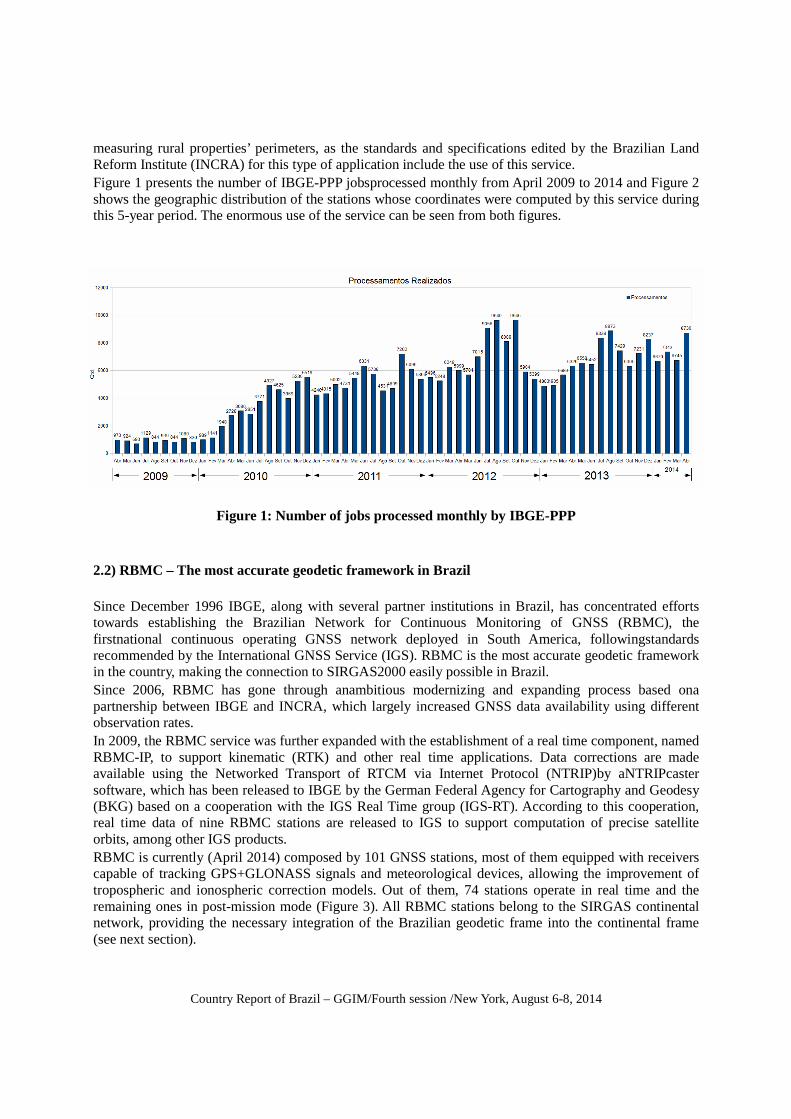
measuring rural properties’ perimeters, as the standards and specifications edited by the Brazilian Land Reform Institute (INCRA) for this type of application include the use of this service. Figure 1 presents the number of IBGE-PPP jobsprocessed monthly from April 2009 to 2014 and Figure 2 shows the geographic distribution of the stations whose coordinates were computed by this service during this 5-year period. The enormous use of the service can be seen from both figures.
Figure 1: Number of jobs processed monthly by IBGE-PPP
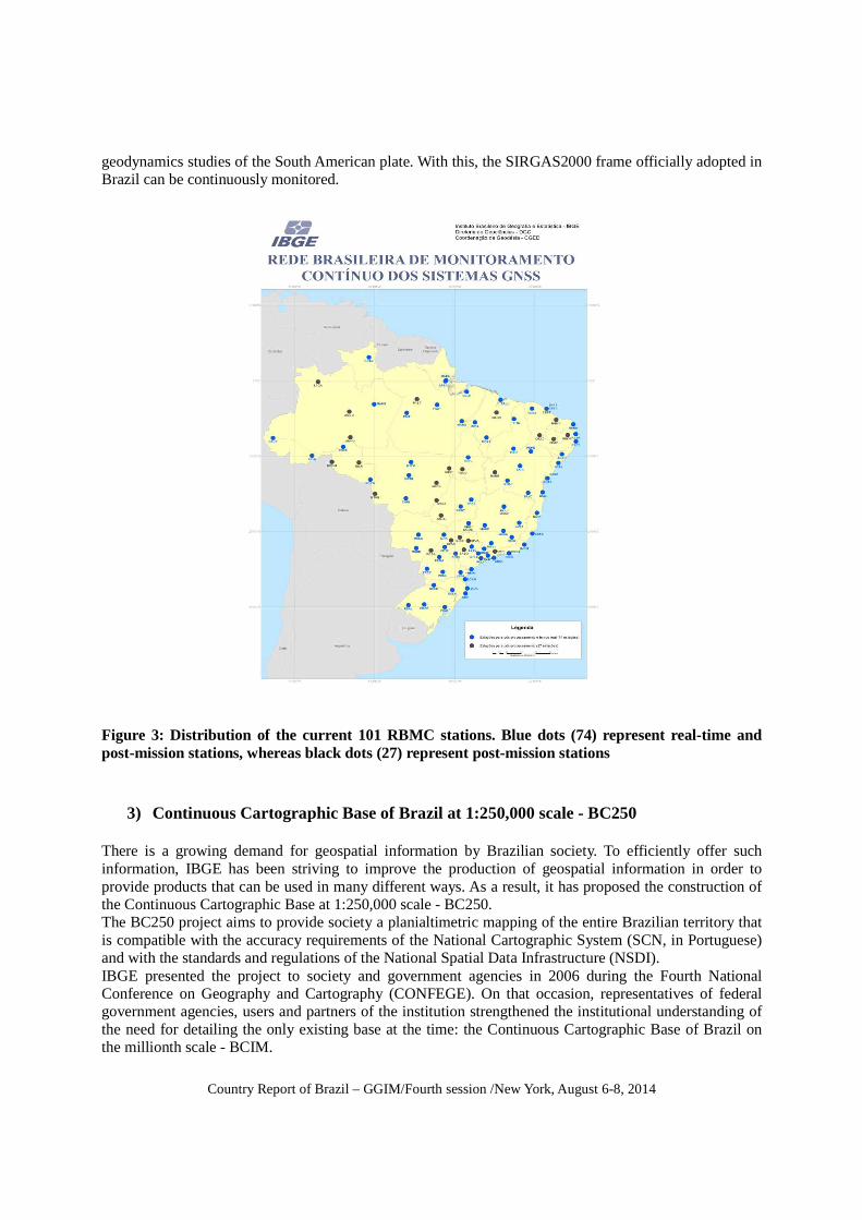
2.2) RBMC – The most accurate geodetic framework in Brazil Since December 1996 IBGE, along with several partner institutions in Brazil, has concentrated efforts towards establishing the Brazilian Network for Continuous Monitoring of GNSS (RBMC), the firstnational continuous operating GNSS network deployed in South America, followingstandards recommended by the International GNSS Service (IGS). RBMC is the most accurate geodetic framework in the country, making the connection to SIRGAS2000 easily possible in Brazil. Since 2006, RBMC has gone through anambitious modernizing and expanding process based ona partnership between IBGE and INCRA, which largely increased GNSS data availability using different observation rates. In 2009, the RBMC service was further expanded with the establishment of a real time component, named RBMC-IP, to support kinematic (RTK) and other real time applications. Data corrections are made available using the Networked Transport of RTCM via Internet Protocol (NTRIP)by aNTRIPcaster software, which has been released to IBGE by the German Federal Agency for Cartography and Geodesy (BKG) based on a cooperation with the IGS Real Time group (IGS-RT). According to this cooperation, real time data of nine RBMC stations are released to IGS to support computation of precise satellite orbits, among other IGS products. RBMC is currently (April 2014) composed by 101 GNSS stations, most of them equipped with receivers capable of tracking GPS+GLONASS signals and meteorological devices, allowing the improvement of tropospheric and ionospheric correction models. Out of them, 74 stations operate in real time and the remaining ones in post-mission mode (Figure 3). All RBMC stations belong to the SIRGAS continental network, providing the necessary integration of the Brazilian geodetic frame into the continental frame (see next section).

Country Report of Brazil – GGIM/Fourth session /New York, August 6-8, 2014
Among several public institutions that participate with important infrastructure toRBMC, INCRA, as previously mentioned, has made great contributions, as well as the Brazilian Space Agency (INPE), which uses RBMC data in the Brazilian Space Weather Program (EMBRACE), in the Positioning Integrated System for Geodynamics Studies(SIPEG) and in the Center for WeatherForecasting and Climate Research (CPTEC). RBMC data is one of the most demanded information available on IBGE’s portal, with more than 400,000 GNSS 24-hour observation files downloaded per month. Regarding its real time component (RBMC-IP), more than 4,000 users are registered to have access to the service.
Figure 2: Geographic distribution of the stations whose coordinates were computed by IBGE-PPP from April 2009 to 2014. Each red dot corresponds to a station.(2) RBMC – The most accurate geodetic framework in Brazil 2.3) SIRGAS Analysis Center As seen in previous sections, Brazil has actively engaged in multinational and national cooperation initiatives, which have contributed tothe advanced geodeticactivities carried out in the country during the past decades. Among these initiatives, the SIRGAS one, which has counted on IBGE’s participation since its beginning in 1993, should be emphasized.In addition to many roles played along these past 20+ years, IBGE is one of the analysis (i.e., processing and combination) centers since 2008, being responsible for the weekly processing of GNSS data collected by 121 SIRGAS continental network (http://www.sirgas.org/index.php?id=61&L=2) stations and for the combination of weekly solutions of nine processing centers, the latter responsibility being shared with the German Geodetic Research Institute (DGFI). The time series of the SIRGASstations’ coordinatesfeed the computation of station velocities, which are very important for the maintenance of the SIRGAS reference frame and for
Country Report of Brazil – GGIM/Fourth session /New York, August 6-8, 2014
geodynamics studies of the South American plate. With this, the SIRGAS2000 frame officially adopted in Brazil can be continuously monitored.
Figure 3: Distribution of the current 101 RBMC stations. Blue dots (74) represent real-time and post-mission stations, whereas black dots (27) represent post-mission stations
3) Continuous Cartographic Base of Brazil at 1:250,000 scale - BC250
There is a growing demand for geospatial information by Brazilian society. To efficiently offer such information, IBGE has been striving to improve the production of geospatial information in order to provide products that can be used in many different ways. As a result, it has proposed the construction of the Continuous Cartographic Base at 1:250,000 scale - BC250. The BC250 project aims to provide society a planialtimetric mapping of the entire Brazilian territory that is compatible with the accuracy requirements of the National Cartographic System (SCN, in Portuguese) and with the standards and regulations of the National Spatial Data Infrastructure (NSDI). IBGE presented the project to society and government agencies in 2006 during the Fourth National Conference on Geography and Cartography (CONFEGE). On that occasion, representatives of federal government agencies, users and partners of the institution strengthened the institutional understanding of the need for detailing the only existing base at the time: the Continuous Cartographic Base of Brazil on the millionth scale - BCIM.

Country Report of Brazil – GGIM/Fourth session /New York, August 6-8, 2014
The BC 250 aims to optimize numerous tasks related to land management, among which we highlight issues related to environmental monitoring, mapping of the remaining vegetation, water resources management, mapping of aquifers that reach several South American countries, monitoring areas subject to environmental hazards/disasters, and cooperation in resolving issues of national borders. The mapping of Brazil at 1:250,000 scale has 555 topographic sheets, 307 of them refer to the Amazon region. The mapping in the Amazon region had been previously scanned and integrated because of the SIVAM project (Amazon Surveillance System). IBGE subsequently provided the entire coverage of the national territory, choosing to hire specialized companies to provide mapping services under the supervision of the institution and with the use of data obtained through partnerships. The BC250 project was executed with investment of the Geographic Information System of Brazil (SIGBrasil) project. In this period, the National Commission of Cartography (CONCAR) launched the first version of the Technical Specification for the Vector Geospatial Data Structuring (ET-EDGV), aimed at structuring and modeling geospatial data. This specification was used in the project. In the scope of the BC250 project, in 2011 it was published the Manual of Technical Procedures for Inspection, Quality Control and Validation of the Continuous Cartographic Base at 1:250,000 scale, due to new methodology applied in the construction of this cartographic base. In 2008, the production of BC250 cartographic base began with the first contract on 100 of a total of 548 sheets of maps on this scale. Working areas (Figure 4) were based on Brazilian biomes in order to meet, primarily, the demands of IBGE`s Coordination of Natural Resources. In 2009 and 2010, six service companies were contracted in a tender process. Five of these companies were to provide mapping services for the production of the remaining 448 sheets. The sixth company was to develop technological solutions for the enhancing of BC250. At the institutional level, efforts have focused on the supervision and quality control of the delivered products. Technicians at headquarters and decentralized units were involved in these activities. IBGE staff was sent to the field to conduct activities of location, identification, classification and element naming. Data obtained in the field has been used to monitor, validate, complement and update the BC250 base information.

Country Report of Brazil – GGIM/Fourth session /New York, August 6-8, 2014
Figure 4 - Map of Brazil with 548 sheets divided into working blocks.
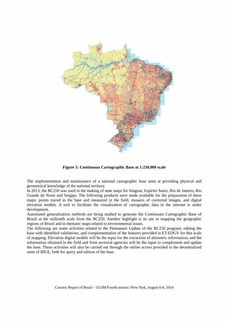
In 2012, the BC250 cartographic base was made available to society with the mapping divided by blocks according to the execution of contracts. In 2013, the continuous base version was launched, available on the NSDI portal (Figure 5). In 2014, the Permanent Update of the BC250 program began. The project is providing solution for mapping at 1:250,000 scale, whose original data had differences in datum, level of generalization and modeling, as well as a lack of updating. Applications and documentation have been prepared so that they could be used by other projects, in other scales and improved. Data with national coverage for seven of the thirteen categories of ET-EDGV information was produced. Data corresponds to the information on hydrography, transportation system, limits, locations, economic structure, communication, and supply and sewage. Cartographic information was obtained by updating the existing mapping or through new mapping, using satellite images, data from field activities and data provided by partner agencies.
Country Report of Brazil – GGIM/Fourth session /New York, August 6-8, 2014
Figure 5: Continuous Cartographic Base at 1:250,000 scale The implementation and maintenance of a national cartographic base aims at providing physical and geometrical knowledge of the national territory. In 2013, the BC250 was used in the making of state maps for Alagoas, Espírito Santo, Rio de Janeiro, Rio Grande do Norte and Sergipe. The following products were made available for the preparation of these maps: points traced in the base and measured in the field, mosaics of corrected images, and digital elevation models. A tool to facilitate the visualization of cartographic data in the internet is under development. Automated generalization methods are being studied to generate the Continuous Cartographic Base of Brazil at the millionth scale from the BC250. Another highlight is its use in mapping the geographic regions of Brazil and in thematic maps related to environmental issues. The following are some activities related to the Permanent Update of the BC250 program: editing the base with identified validations, and complementation of the features provided in ET-EDGV for this scale of mapping. Elevation digital models will be the input for the extraction of altimetric information, and the information obtained in the field and from sectorial agencies will be the input to complement and update the base. These activities will also be carried out through the online access provided to the decentralized units of IBGE, both for query and edition of the base.

Country Report of Brazil – GGIM/Fourth session /New York, August 6-8, 2014
4) Planning the territorial base for statistical surveys
Before each census operation, IBGE updates the information on the geographical reality of the country, and stores it in geospatial databases. This graphic and cadastral information form the so-called Territorial Base, which is defined as the set of records and maps developed from new technologies based on Geographic Information Systems (GIS). Its main purpose is to preserve the correct representation of the existing territorial framework in order to ensure proper verification and dissemination of results. The characterization of the national territory, in its fundamental aspects, occurs from the graphical delimitation and textual description of the minimum collection unit, that is, the enumeration area, something that guarantees the recognition of the working area by the enumerator and prevents the occurrence of omissions and/or duplications that would impair the coverage of the survey. In addition, the planning of information contained in the territorial base allows sizing the volume and cost of the collection operation as a whole, since the number of enumeration areas and their typology also define human and material resources that will be used. The construction of the territorial base Planning the territorial base begins by the legal political-administrative division in force in the country. After reviewing these limits, respecting the constitutional hierarchies, other operations concerning limits are defined, including the areas for counting and dissemination of data, and the specification of the Brazilian territory according to a rural-urban framework. Operations linked to the production of the territorial base also consider special features for the classification of both urban and rural enumeration areas. Such features are defined according to social tendencies, economic activities, purpose of use or environmental conservation, and, more recently, cultural conservation. The classification of enumeration areas is translated into numeric codes according to criteria and concepts that comprise the scope of the territorial base, and is stored in the database of geospatial data for the production of inputs that will be used in the collection and dissemination of data. Consulting cadastral data in the territorial base allows the retrieval of information on the territorial hierarchy, legislation concerning the creation of municipalities and districts, urban perimeters, installation, termination, change of place names, among others, in order to monitor the historical evolution of the Brazilian Territorial Division, as well as of the political, administrative and geographical dimensions of the country. Likewise, it is possible to retrieve information gathered in previous operations, providing the statistical comparability of the enumeration areas, something that subsidizes the analysis and monitoring of social, political, economic and demographic aspects of the population and the territory. A major product of the territorial base is the enumeration area mesh, which is a digital vector file resulting from such base, and that will follow statistical surveys from collection to dissemination. Based on existing topographical and cadastral scale mappings, it is constantly updated with inputs coming from remote sensing, GPS, and other cartographic documents, including information gathered in the field by previous statistical surveys. Cartographic updates find an important subsidy in the National Address for Statistics (CNEFE) currently associated to block-faces, georeferencing the addresses of visited households in urban areas and collecting geographical coordinates of rural households.

Country Report of Brazil – GGIM/Fourth session /New York, August 6-8, 2014
The size of Brazil, as well as its geographical diversity, requires different strategies to maintain our cartographic basis updated for census operations. Remote sensing images contribute to the most appropriate and modern cartographic study of difficult access areas, or with no mapping at all, facilitating also the adjustment of the polygons that form enumeration areas and their corresponding morphological elements. This activity, which involves a considerable number of technical personnel capable of handling computer applications on satellite images associated with geospatial databanks, considerably improved georeference information produced in the institution. Preparatory actions for constructing the enumeration areas mesh are consolidated with the record and criticism of the alphanumeric systems of the territorial base and the digital reading of the lines that define the limits of the municipalities, as well as urban and rural sectors on the cartographic database stored in geospatial databanks, from which maps used during data collection (which, in turn, is made with hand-held computers coupled with GPS) are produced. This procedure meant both the flexibility to the operation and the accuracy of the information, whose download allowed a faster follow-up and dissemination of results. To operationalize the work of the enumerator, enumeration areas must meet the defined criteria of size, which, in urbanized areas, comprise 250-400 households, approximately, making it possible to cover the area within 30 days. As for rural sectors, quantitative limits are 200 households or 150 agricultural establishments on average, assuming a variation range of 150-250 households and 100-200 agricultural establishments. In rural areas, given the difficulties of access, territorial extension is considered the parameter for defining the size of the enumeration area, besides the number of establishments or private households, which in this case are within the area of 500 km2, collection time being, at most, 60 days. Once enumeration areas are defined according to the coding system that is registered in the territorial base, and once the graphic files resulting from alphanumeric information are treated, the next territorial base activity is the production, in various formats and standards, of municipal maps, municipal statistical maps, location maps, and maps of urban and rural enumeration areas, from the integration of information stored in the geospatial databank by the mapping system developed by IBGE.
5) Integration of Geographical and Statistical Information
Brazil is one of the few countries in the world that brings together, in a single institution, the production and dissemination of geographical and statistical information. This fact is both an incentive and an opportunity to integrate geographical, statistical, and production data and metadata of a cartographic base which is accurate in terms of collection, dissemination and analysis of surveys. In the following text, we highlight, as a central element of the integration of geography and statistics, the development of appropriate territorial areas/limits for data collection and dissemination concerning both Census and sample surveys, adopting the standards of the National Spatial Data Infrastructure (NSDI) as a key element in this process.
Country Report of Brazil
Approaches adopted at IBGE for
Geographical Units
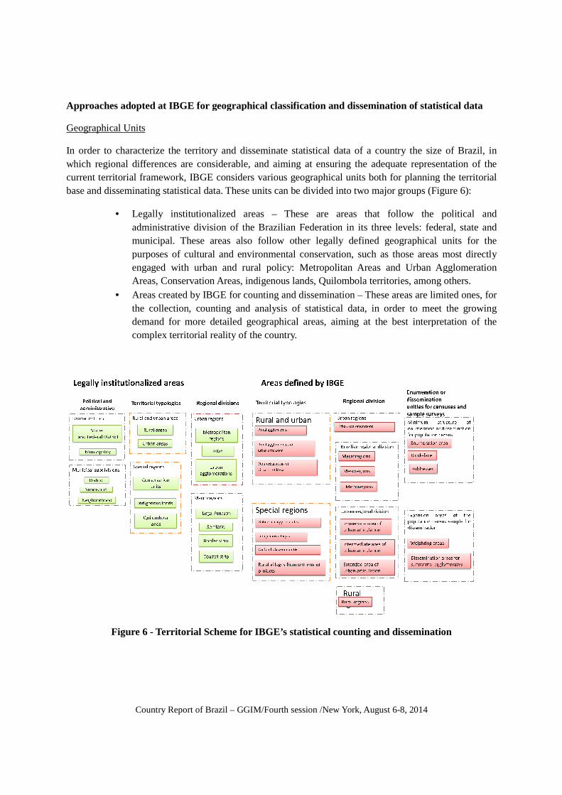
In order to characterize the territory and disseminate statistical data of a country the size which regional differences are considerablecurrent territorial framework, IBGE considers various geographicbase and disseminating statistica
• Legally institutionalized areasadministrative division of the Brazilian Federation in its municipal. These areas also purposes of cultural and environmental conservation, such as those areas most directly engaged with urban and rural policy: Metropolitan Areas and Areas, Conservatio
• Areas created by IBGE for the collection, counting demand for more complex territorial reality of the country.
Figure 6 - Territorial
Country Report of Brazil – GGIM/Fourth session /New York, August 6
for geographical classification and dissemination of statistical data
characterize the territory and disseminate statistical data of a country the size are considerable, and aiming at ensuring the adequate representation of the
current territorial framework, IBGE considers various geographical units both for statistical data. These units can be divided into two major groups (Figure 6
Legally institutionalized areas – These are areas that follow administrative division of the Brazilian Federation in its three levels: federal, state and
ese areas also follow other legally defined geographical units purposes of cultural and environmental conservation, such as those areas most directly engaged with urban and rural policy: Metropolitan Areas and
Conservation Areas, indigenous lands, Quilombola territories, among others.Areas created by IBGE for counting and dissemination – These areas
, counting and analysis of statistical data, in orderre detailed geographical areas, aiming at the best interpretation of
complex territorial reality of the country.
Territorial Scheme for IBGE’s statistical counting and disseminati
GGIM/Fourth session /New York, August 6-8, 2014
geographical classification and dissemination of statistical data
characterize the territory and disseminate statistical data of a country the size of Brazil, in adequate representation of the
for planning the territorial into two major groups (Figure 6):
follow the political and ree levels: federal, state and geographical units for the
purposes of cultural and environmental conservation, such as those areas most directly engaged with urban and rural policy: Metropolitan Areas and Urban Agglomeration
territories, among others. These areas are limited ones, for
in order to meet the growing the best interpretation of the
and dissemination
Country Report of Brazil – GGIM/Fourth session /New York, August 6-8, 2014
Political-administrative division
Brazil is a Federation composed of autonomous entities: the Union, the States and the Municipalities. Its political-administrative division sets the border of the country, state divisions, and municipal, district and sub-district limits, in accordance with the 1988 Brazilian Constitution, which, in turn, is regulated in specific legislation. Municipalities may be divided into neighborhoods.
Territorial typologies
These are territorial classifications, from previously established criteria, in order to identify spatial patterns of interest for statistical dissemination, in order to meet the various demands of society. From a legal standpoint, an example of territorial typology is the classification of territory in rural and urban areas and also in the definition of units of special interest, such as: Conservation Units, Indigenous Lands, Quilombola Territories etc.
Urban areas, for example, are classified by IBGE nationwide, from morphological criteria that produce a more refined picture of the urban phenomenon in Brazil.
In the urban context, it is worth noting the delimitation of the so-called Subnormal Agglomerates, allowing the dissemination of detailed statistics for these areas, which are of strong social interest, as well as assisting in the planning of specific public policies.
Regional divisions
These are geographic units formed by clusters of municipalities, which make a synthetic regional framework or set up a regional framework based on specific criteria such as those derived from characteristics of the urban network or from the dominant rural activities.
Regional divisions are legally defined in the federal and state levels, and are intended to support regional planning. Federal legislation governs the definition of macroregions, such as the Legal Amazon, the Semi Arid, the Frontier Line and Coastal Zones. State legislation, in turn, defines urban regions, involving Metropolitan Areas, regions at the influence of cities (RIDE), and other Urban Agglomerations.
The diversity of criteria contained in state legislation for the identification of Urban Agglomerations and Metropolitan Areas prevents a comparative analysis of the urban phenomenon in the country. In order to have an overview of the entire national territory under the same urban perspective, IBGE establishes operational criteria for identifying agglomerations, considering the concept of clusters of municipalities, something that allows the analysis of statistical information in various contexts and geographical scales.
Besides Urban Agglomerations, other regional frameworks are created by IBGE in order to allow the analysis of statistical information in different scales and contexts, always formed by clusters of municipalities. A more integrated regional framework is the division of the country into three different scales (macroregions, mesoregions and microregions) based on characteristics of the natural setting, the organization of production and its integration and social processes.
IBGE also provides, for the dissemination of statistical data, a regional division based on the urban network (Urban Regional Division) and one based on the characteristics of the agrarian space (Rural Regions).
Country Report of Brazil – GGIM/Fourth session /New York, August 6-8, 2014
Collection/Dissemination Unit (Census and samples)
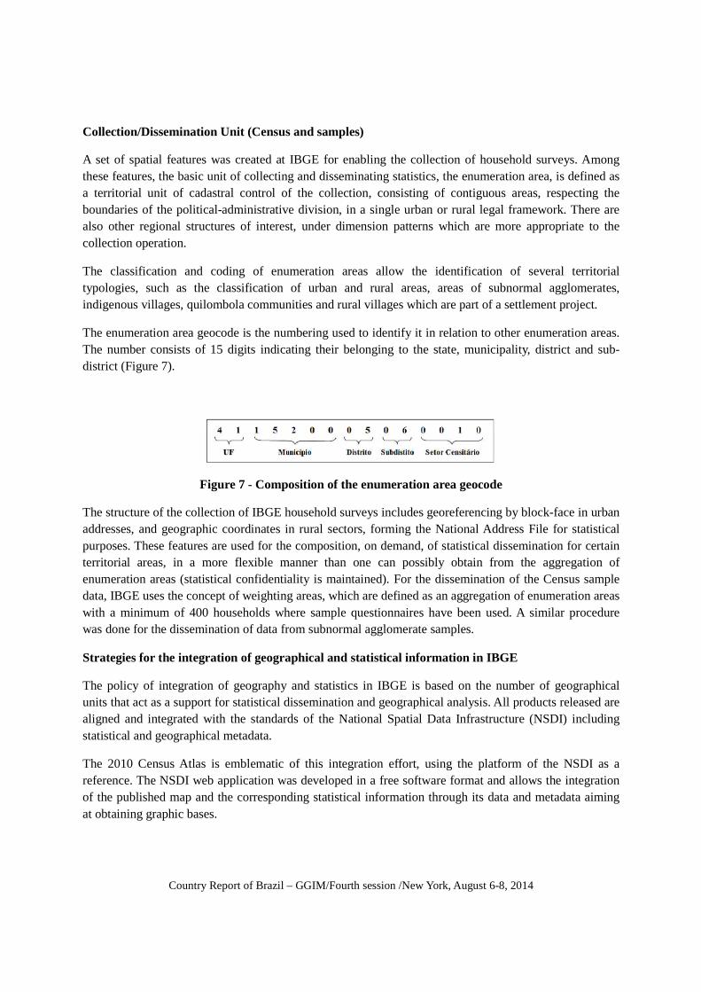
A set of spatial features was created at IBGE for enabling the collection of household surveys. Among these features, the basic unit of collecting and disseminating statistics, the enumeration area, is defined as a territorial unit of cadastral control of the collection, consisting of contiguous areas, respecting the boundaries of the political-administrative division, in a single urban or rural legal framework. There are also other regional structures of interest, under dimension patterns which are more appropriate to the collection operation.
The classification and coding of enumeration areas allow the identification of several territorial typologies, such as the classification of urban and rural areas, areas of subnormal agglomerates, indigenous villages, quilombola communities and rural villages which are part of a settlement project.
The enumeration area geocode is the numbering used to identify it in relation to other enumeration areas. The number consists of 15 digits indicating their belonging to the state, municipality, district and sub-district (Figure 7).
Figure 7 - Composition of the enumeration area geocode
The structure of the collection of IBGE household surveys includes georeferencing by block-face in urban addresses, and geographic coordinates in rural sectors, forming the National Address File for statistical purposes. These features are used for the composition, on demand, of statistical dissemination for certain territorial areas, in a more flexible manner than one can possibly obtain from the aggregation of enumeration areas (statistical confidentiality is maintained). For the dissemination of the Census sample data, IBGE uses the concept of weighting areas, which are defined as an aggregation of enumeration areas with a minimum of 400 households where sample questionnaires have been used. A similar procedure was done for the dissemination of data from subnormal agglomerate samples.
Strategies for the integration of geographical and statistical information in IBGE
The policy of integration of geography and statistics in IBGE is based on the number of geographical units that act as a support for statistical dissemination and geographical analysis. All products released are aligned and integrated with the standards of the National Spatial Data Infrastructure (NSDI) including statistical and geographical metadata.
The 2010 Census Atlas is emblematic of this integration effort, using the platform of the NSDI as a reference. The NSDI web application was developed in a free software format and allows the integration of the published map and the corresponding statistical information through its data and metadata aiming at obtaining graphic bases.

Country Report of Brazil – GGIM/Fourth session /New York, August 6-8, 2014
Pespectives
Integration of the IBGE Automatic Recovery System (SIDRA) to produce geoservices in accordance with NSDI standards. This procedure will allow the user to create maps in a customized way with statistical data produced by IBGE. Creation of common fields in the structure of the NSDI to improve the integration between spatial and statistical data and metadata. Creation of a grid for the dissemination of statistical data.