DIGITAL TERRAIN MODEL (DTM) AS A TOOL FOR LANDSLIDE ...
20
S T U D I A G E O M O R P H O L O G I C A C A R P A T H O - B A L C A N I C A VOL. XLVI, 2012: 5–23 PL ISSN 0081-6434 MICHA£ D£UGOSZ (KRAKÓW) DIGITAL TERRAIN MODEL (DTM) AS A TOOL FOR LANDSLIDE INVESTIGATION IN THE POLISH CARPATHIANS Abstract. This paper present the possibilities of using digital terrain model in landslide investiga- tions in the Polish Flysch Carpathians. The analysis was based on results of SOPO project which was made in the £u¿na commune and on GIS interpretation of DTM model with topographical map. On the basis of the interpretation of a properly prepared DTM elevation model, 76 areas of potential occurrence of landslides in the £u¿na commune were defined. In 51 cases from among the 76 defined areas, the presence of landslides, within the selected unit, was confirmed during the field study. The interpretation of the digital terrain model in conjunction with a topographic map gave similar results. Areas of potential occurrence of landslides in both methods were practically identical (area of 600 ha). Despite the landslide area designated more accurately by the DTM, the analysis of topographic maps in conjunction with the DTM gave slightly better results, designating 11 more areas as places of land- slide occurrence. The digital terrain model (DTM), available for the area of the Polish Carpathians, can be useful in the study of landslides. It depends on the type of landslides, type of relief and the degree of forest landcover. Key words: landslide, digital terrain model, GIS, the flysch Carpathians INTRODUCTION The high amount of precipitation, floods, and accompanying landslides that oc- curred in the basins of the Upper Vistula and the Oder in 1997, 2000, and 2001 aroused the interest of the state administration and local authorities on the problem of landslides in the Polish Carpathians. The immediate impulse that drew attention to this problem was the huge financial losses caused by the development of such forms on the slopes of various parts of the Carpathian Mountains. This contributed to a change in legislation in Poland, and landslides, as well as floods, were thereafter considered natural disasters (Act of 18 April 2002 on the status of a natural disaster, Journal of Laws of 2002. No. 62, item 558). The actions taken to minimize the losses brought on by the development of landslides resulted in developing and implementing the Landslide Counteracting DOI 10.2478/v10302-012-000 - 13 Unauthenticated Download Date | 5/6/15 11:10 AM
Transcript of DIGITAL TERRAIN MODEL (DTM) AS A TOOL FOR LANDSLIDE ...

5S T U D I A G E O M O R P H O L O G I C A C A R P A T H O - B A L C A N I C A
VOL. XLVI, 2012: 5–23 PL ISSN 0081-6434
MICHA£ D£UGOSZ (KRAKÓW)
DIGITAL TERRAIN MODEL (DTM) AS A TOOL FOR LANDSLIDE INVESTIGATION
IN THE POLISH CARPATHIANS
Abstract. This paper present the possibilities of using digital terrain model in landslide investiga-tions in the Polish Flysch Carpathians. The analysis was based on results of SOPO project which was made in the £u¿na commune and on GIS interpretation of DTM model with topographical map. On the basis of the interpretation of a properly prepared DTM elevation model, 76 areas of potential occurrence of landslides in the £u¿na commune were defined. In 51 cases from among the 76 defined areas, the presence of landslides, within the selected unit, was confirmed during the field study. The interpretation of the digital terrain model in conjunction with a topographic map gave similar results. Areas of potential occurrence of landslides in both methods were practically identical (area of 600 ha). Despite the landslide area designated more accurately by the DTM, the analysis of topographic maps in conjunction with the DTM gave slightly better results, designating 11 more areas as places of land-slide occurrence. The digital terrain model (DTM), available for the area of the Polish Carpathians, can be useful in the study of landslides. It depends on the type of landslides, type of relief and the degree of forest landcover.
Key words: landslide, digital terrain model, GIS, the flysch Carpathians
INTRODUCTION
The high amount of precipitation, floods, and accompanying landslides that oc-curred in the basins of the Upper Vistula and the Oder in 1997, 2000, and 2001 aroused the interest of the state administration and local authorities on the problem of landslides in the Polish Carpathians. The immediate impulse that drew attention to this problem was the huge financial losses caused by the development of such forms on the slopes of various parts of the Carpathian Mountains. This contributed to a change in legislation in Poland, and landslides, as well as floods, were thereafter considered natural disasters (Act of 18 April 2002 on the status of a natural disaster, Journal of Laws of 2002. No. 62, item 558).
The actions taken to minimize the losses brought on by the development of landslides resulted in developing and implementing the Landslide Counteracting
DOI 10.2478/v10302-012-000 -1 3
UnauthenticatedDownload Date | 5/6/15 11:10 AM

6
System (SOPO — System Os³ony Przeciwosuwiskowej). Its primary purpose is to identify, document, and mark on the map (scale 1:10,000) all landslides and areas potentially endangered by mass movements in Poland. The results of the project are to help in the management of landslide risk, that is, in reducing to a large extent loss and damage caused by the development of landslides. For that to happen, further road construction and housing in the area of active — and pe-riodically active — landslides should be abandoned (http://geoportal.pgi.gov.pl).
For the sake of the SOPO project’s realization, the Instruction to draw up a map of landslides and mass movement risk areas was elaborated (in the scale of 1 : 10,000). Its main purpose was to introduce uniform rules for mapping areas of landslide risk, land movements, and also to monitor landslides (G r a b o w s k i et al. 2008). The Instruction includes fieldwork methodology related to landslide mapping as well as a standardized glossary of terms in the field of landslide issues.
Subsequently, a script was prepared that was dedicated to the methodology of analytical and cartographic problems of landslides in the Polish Carpathians (O z i m k o w s k i et al. 2010). The aim of the study was to identify the most useful and effective methods of diagnosis and documentation of landslides that should lead to high-quality end results. This applies both to analytical work (before the mapping), and to the mapping in the field itself (O z i m k o w s k i et al. 2010). In the section on analytical work, authors fully describe the possible use of topographic maps in the preparatory work. Much less attention was paid to the use of a digital elevation model of the area.
The article presents the results of research done within the SOPO project on the possibility of using digital terrain model (DTM) in preparing maps of landslides and areas at risk of landslides. The main objective of this article is to demonstrate the extent to which the analysis of DTM and topographic maps help in fieldwork and final preparation of maps of landslides and areas at risk of landslides. The article summarizes a range of information necessary in de-termining areas of potential landslides and on the methodology of the DTM analytical work.
THE APPLICATION OF DEM/DTM TO THE LAND RELIEF EXAMINATION
Digital Elevation Model (DEM) is a mathematical representation of the terrain surface represented by a data set of specific coordinates that enables informa-tion about the height of any point to be obtained (H e n g e l, E v a n s (2009) vide To m c z y k, E w e r t o w s k i (2009)). Through the use of mathematical and statistical tools, a quantitative description of the earth’s surface is feasible. The use of DEM allows one to section, among others, the basic elements of landforms, describe structures of the land relief and define certain parameters, such as slope, exposure, or the relative height (To m c z y k, E w e r t o w s k i
UnauthenticatedDownload Date | 5/6/15 11:10 AM

7
2009). In the literature, apart from the DEM name, other terms are also com-monly used, such as NMT in Polish literature (N i t a et al. 2007, W o l s k i 2007, W o j c i e c h o w s k i 2008), and its English-language counterpart, Digital Terrain Model (DTM) (M a n i a 2007). Digital terrain model represents the bare ground surface without any objects like plants and buildings (L i et al. 2005). The term Digital Elevation Model is often used as a generic term, only representing height information without any further definition about the surface.
The possibilities of using DEM in exploring the Earth’s surface depend mainly on the resolution and quality of the source material upon which the model was created (H v r a t i o n, P e r k o 2005). DEM resolution is the ability to record specific information, both horizontally and vertically. A minimum sur-face of an object that would enable one to make a reproduction on the model should be about three times larger than the surface of a raster (To m c z y k, E w e r t o w s k i 2009). DEM in raster form is expressed by a cell matrix with the coordinates x, y, z, which allows for the precise measurement of absolute height of any point.
Digital elevation models are widely used in geological and geomorpholog-ical studies as auxiliary tools or primary source of data (O s t a f i c z u k 2003, S z e k e l y, K a r a t s o n 2004; B a d u r a, P r z y b y l s k i 2005; N i t a et al. 2007, K a s p r z a k, T r a c z y k 2010; N i t a 2010). They form a basis for the diagnosis and automatic calculation of morphometric parameters of the land’s surface and hydrological parameters, including drainage networks and drainage lines (K r o c z a k 2010). DEM is also an integral part of modeling and forecasting temporary morphogenetic processes (e.g. D e m c z u k 2009, Te r r a n o v a et al. 2009, K r o c z a k 2010). The development of geographic information systems (GIS) techniques and statistical mathematical tools also enable the use of the digital terrain model in the analysis of automatic or semi-automatic classifications of relief (M i n a r, E v a n s 2008).
Thanks to the substantial capabilities of land relief visualization, elevation terrain is also used in the study of landslides. The possibility to lighten the ana-lyzed model of the earth’s surface at any angle and at any height enables the identification and definition of the landslide’s relief (V a n D e n E e c k h a u t et al. 2005, W o j c i e c h o w s k i 2008, H r a d e c k y et al. 2007). Apart from the simple visualization of the terrain’s surface, DEM has been widely used in the assessment of susceptibility to landslide and of landslide risk (e.g. M o n t o v a n i et al. 1996, C l e r i c i et al. 2002, M r o z e k et al. 2004, M r o z e k 2008, D ³ u- g o s z 2009, 2011a, b; P i a c e n t i n i et al. 2012). Thanks to the use of the eleva-tion model, there is also the possibility of doing morphometric measurements of particular parameters within the landslide, such as length, width, slope and exposure, or to draw longitudinal and transverse profiles within the form.
UnauthenticatedDownload Date | 5/6/15 11:10 AM

8
STUDY AREA
The study was conducted for the £u¿na commune area. Within the SOPO pro-ject, a map of landslides and areas at risk of mass movements was made. The project was carried out by members of the Institute of Geography and Spatial Organization of the Polish Academy of Sciences.
The £u¿na commune is located in the northwestern end of the Jas³o and Sanok valleys, on the border of the Ciê¿kowickie Foothills to the west, and Low Beskid to the south (S t a r k e l 1972) (Fig. 1). Administratively, it is a part of Gorlice County, which lies in the southeastern part of the Lesser Poland Voivodeship. It is a rural commune with an area of 56.24 km2. It is mainly ar-able land (71.1% of the total area). Forest terrain constitutes 20.1% of the area, and covers mainly steep slopes and ridges of hills as well as headwater areas (R ¹ c z k o w s k a 2011).
The area of the £u¿na commune, in geomorphologic terms, has been rec-ognized as part of the Carpathians province, Western Carpathians subprovince,
Fig. 1. Study area
UnauthenticatedDownload Date | 5/6/15 11:10 AM

9
mezoregion of the Jas³o and Sanok valleys (S t a r k e l 1972). The area is hilly, and the land relief is formed of low foothills, partly medium-height, with a high proportion of valley bottoms and low hills in its eastern part (S t a r k e l 1972, 1980). In the southern part of the commune area, the terrain characteristics are different. From the southern side, the £u¿na Valley is limited by the hills. These are, from west to east, Zielona Góra (689.7 m), Bucze (585.3 m), and Kozia Góra (424 m). According to L. S t a r k e l (1972), they can be classified as medium insular mountains scattered among uplands. The ridges rise up to about 300 m above the bottom of the £u¿na Valley, and the slope gradient exceeds 25°.
GEOLOGY
The £u¿na commune is located in the Outer Carpathians, on the border of two units: the Silesian and Magura Nappes. The western part of the commune lies within the folded synclinal zone of the Silesian unit (the £êk zone, which
Fig. 2. Geology
UnauthenticatedDownload Date | 5/6/15 11:10 AM

10
is an extension to the east of the Bobowa syncline), filled with the Krosno beds, among which narrow streaks of Eocene sediments and menilit beds can be seen. Krosno beds are composed mainly of sandstone (thick, medium, and thin-bedded) and shales, which constitute 41% of the commune area (Fig. 2) (N e s c i e r u k et al. 1995).
The eastern and central part of the commune lies within the £u¿na penin-sula, which belongs to the Magura unit, Raczany and Siar subunit.. The £u¿na peninsula is a characteristic element of the Magura Nappe’s edge, which is slid onto Bobowa syncline in the northern direction. In this area, there is a tectonic window of Mszanka, where formations of the Silesian Nappe and Neogen molas-ses, lying on the folded Carpathians, appear (Œ w i d z i ñ s k i 1950, N e s c i e r u k et al. 1995, 1996). The area of the £u¿na commune within the £u¿na peninsula has a complicated geological structure. For the most part it is built of sandstone and shale of inoceram beds (24% of the commune’s area). These beds form a large patch in the southeast part of the commune and at its northern bor-der, in the region of Pustki Mountain (Fig. 2) (N e s c i e r u k et al. 1995). The inoceram beds are separated by a zone of variegated shales, formed as red, green and gray loam shale (21% of the commune’s area). From the northeast, the beds under the Magura Unit adjoin shale formations, formed as shale, clay stone, and sandstone (N e s c i e r u k et al. 1995) (6% of the commune’s area).
LANDSLIDES
During field mapping in the £u¿na commune, 316 landslides with a total area of 841.58 ha were identified (Fig. 3). These are mainly rotational slides, formed in weathered and rocky-weathered material. The landslide density ratio G = n/P, worked out by L. B o b e r (1984), for the commune is 5.63 km2, whereas the landslide gradient Op = 15.03%. Within the £u¿na commune, there are three main zones of landslide occurrence. The first of them, and the largest one, is located in the southern part of the commune, on the slopes of the Zielona Mt. and in the area of the village of Bieœnik. Landslides that occur here are rocky slides, as well as rocky-weathered material slides, with well-marked elements of landslide relief, whose main scarps reach 30 m in height. These are mostly inactive forms or periodically active. The area of landslides often exceeds 50 ha. The second of these regions is located in the northern part of the commune, on the slopes of Pustki Mountain, whose slopes are almost entirely covered by landslides. There are both big rocky landslides and large accumulations of small weathered material landslides. The third sector is located in the eastern part of the commune, on the slopes of Kozia Mt. On its northern slope, there is the largest landslide in the £u¿na commune. Its area covers 88 ha.
The distribution and morphometric parameters of landslides are largely conditioned by a complex geological structure of the area. The vast majority of
UnauthenticatedDownload Date | 5/6/15 11:10 AM

11
large rocky and rocky-weathered material landslides developed within the forms of the Magura Nappe (193 landslides). Landslides of this type usually formed within the inoceram beds and on contact spots with the younger formations (variegated shales). The number of landslides developed within the Silesian Nappe is much smaller (107 landslides). Small weathered material slides domi-nate, located within headwater areas of V-shaped valleys, as well as landslides located within the break of valleys’ slopes. Their area does not exceed 10 ha.
MATERIALS AND METHODS
Various digital elevation models are available for the Polish territory. They are characterized by varied resolution, and thus by different degrees of usefulness for specific analyses. SRTM models of 90 × 90 m cell size, as well as the DTED
Fig. 3. Landslides in the £u¿na commune
UnauthenticatedDownload Date | 5/6/15 11:10 AM

12
model of 20 × 20m raster size, are used in the large-scale analyses (D ³ u g o s z 2009). However, they are too general to be used for registration of landslides in the Carpathians. In the analytical work preceding the field mapping of the £u¿na commune, the Digital Terrain Model (DTM) developed by the Regional Documentation Center of Geodesy and Cartography at the Marshal’s Office of Lesser Poland Voivodeship was used. This model is based on aerial photographs in the scale of 1 : 13,000 made for the area of the Polish Carpathians in 2003. In its creation, photogrammetric techniques were used. DTM is available in three formats: ASCII, TIN, and TTN. Its elevation accuracy in mountainous areas is 1.5 m, and the horizontal resolution reaches 1 m. (http://www.codgik.gov.pl/sko-row/nmt/nmt.php). For the analysis for the area of the commune, topographic maps (scale 1 : 10,000) were also used. These maps also come from the collec-tions of the Regional Documentation Center of Geodesy and Cartography in Krakow. A major advantage of the materials used was their perfect complemen-tation, which makes spatial analyses very easy.
The study consisted of two parts. First, the analysis of digital terrain model was made. This consisted in land relief visualization by illuminating the digital terrain model from different directions and angles (W o j c i e c h o w s k i 2008, K a m i ñ s k i 2007). Thanks to this method, with every change of light, other relief folds were obtained, which allowed the landslide areas to be determined. To determine the range of landslides, eight illumination positions were selected, including four directions (45°, 135°, 225°, 315°) and two angles (50°, 70°) (Fig. 4). This operation was performed for three chosen landslides in the northern, cen-tral, and southern part of the commune. On this basis, the four best illumination positions were chosen, which were subsequently used to determine the potential extent of landslides across the commune. These positions were also adjusted in the course of the digitization of areas of potential landslide occurrence. On the slopes of large denivelation, a 70°-angle illumination was applied, with varied azimuth, depending on slope exposure (aspect W and N — azimuth 45°; E and S — azimuth 315°). In the area of smaller denivelations, a 50°-angle illumination was used, by the same azimuths for W and N expositions and E and S as in the case of large denivelations areas.
The end result of the work was a map of potential landslide occurrence in the £u¿na commune. This map was compared to the final map of landslides, worked out through a field mapping. Using GIS tools, the coverage degree of the two layers was defined, as well as a number of regularities concerning the possibility of using DTM in the study of landslides in the Carpathians.
The second phase of the research was to carry out a similar analysis with use of a topographic map and an digital terrain model. Topographic maps at a scale of 1 : 10,000 were overlapped on a shaded digital terrain model, which was illuminated from the direction of 45° under the angle of 50°. The topographic maps were set as a translucent layer (33.6%), enabling the content of the maps able to be correlated with digital terrain model; a relief picture facilitated this
UnauthenticatedDownload Date | 5/6/15 11:10 AM

13
analysis (Fig. 5). Additionally, a three-dimensional elevation was used to obtain better results and get more details of the land relief. During the analysis, a 3D image display of the analyzed land patch was used. Such an image, in many cases, made it easier to interpret and determine potential landslide area. By dint of digitization, another layer of potential areas of landslide occurrence was
Fig. 4. Comparison of eight position highlight the DTM, landslides at the Pustki Mt.
UnauthenticatedDownload Date | 5/6/15 11:10 AM

14
worked out, which, as in the case of DTM analysis, was compared with the final map of landslides in the £u¿na commune.
All the maps of landslides and analyses were prepared by use of GIS soft-ware. The “Global Mapper 6” program gave a basis for the interpretation of the DEM and topographic maps followed by working out the maps of potential land-slide occurrence. Further comparative analyses were carried out using ILWIS (Integrated Land and Water Information System).
RESULTS
On the basis of the interpretation of a properly prepared digital terrain model, 76 areas of potential occurrence of landslides in the £u¿na commune were defined (Fig. 6). The total area of this type of areas was 913 ha (9.1 km2). After comparing the obtained thematic layer with the final map of landslides worked out within the SOPO project, a number of regularities were identified. In 51 cas-es among the 76 defined areas, the presence of landslides, within the selected unit, was confirmed. In the case of a potential 19 landslides, no traces of such forms were confirmed in the relief. The smallest landslide detected with use of the DTM analysis had the surface of 0.3 ha. The number of landslides that had not been detected in the analysis was 265.
Fig. 5. Thematic Layer prepared for analytical work. Topographic map superimposed on DTM (transparency 33,6%)
UnauthenticatedDownload Date | 5/6/15 11:10 AM

15
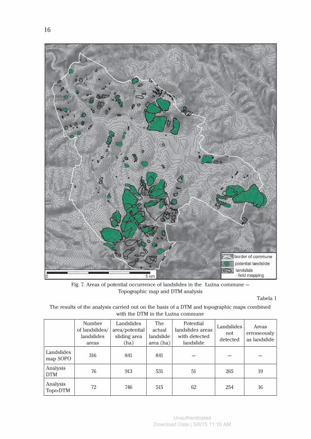
The interpretation of the digital terrain model in conjunction with a topo-graphic map allowed us to predict 72 areas with a total area of 746 ha recognized as potential landslides (Fig. 7). The presence of the landslide was confirmed for 62 of such areas. In the case of 16 areas recognized as landslide, no evidence of landslides during field mapping was identified. Number of landslides that had not been detected in the analysis amounted to 254 forms.
The analysis of results with the use of the DTM, as well as analysis of top-ographic maps in conjunction with the DTM gave similar results. The total area of landslides in the £u¿na commune, computed on the basis of field mapping amounted to 845.5 ha. The DTM analysis allowed a landslide area of the total acreage of 531 ha to be designated. However, the actual landslide area designated on the basis of topographic maps and DTM model was 515 ha (Tab. 1).
Fig. 6. Areas of potential occurrence of landslides in the £u¿na commune — DTM analysis
UnauthenticatedDownload Date | 5/6/15 11:10 AM
16
Fig. 7. Areas of potential occurrence of landslides in the £u¿na commune — Topographic map and DTM analysis
Number of landslides/
landslides areas
Landslides area/potential sliding area
(ha)
The actual
landslide area (ha)
Potential landslides areas
with detected landslide
Landslides not
detected
Areas erroneously as landslide
Landslides map SOPO
316 841 841 — — —
Analysis DTM
76 913 531 51 265 19
Analysis Topo-DTM
72 746 515 62 254 16
Tabela 1
The results of the analysis carried out on the basis of a DTM and topographic maps combined with the DTM in the £u¿na commune
UnauthenticatedDownload Date | 5/6/15 11:10 AM

17
Areas of potential occurrence of landslides in both methods were prac-tically identical (area of 600 ha). Despite the landslide area designated more accurately by the DTM, the analysis of topographic maps in conjunction with the DTM gave slightly better results, designating 11 more areas as places of landslide occurrence.
Throughout the research, we can see a regularity of a bigger over-interpreta-tion of the relief in the case of the DTM analysis. The area of a potential landslide was the highest in relation to the area designated on the basis of topographic maps in conjunction with the DTM. This area, in turn, was significantly bigger than the actual size of the landslide area (Fig. 8).
On the basis of those analyses, a variety of possible uses of the DTM and topographic maps in areas of different relief types can also be seen. Both anal-yses confirmed a greater effectiveness of the method in the southern part of the commune where the Beskid-like relief dominates. This is due mainly to the morphology of landslides occurring in that region. This part of the commune is dominated by large rocky and weathered material landslides with clearly formed main scarps and slopes, as well as colluvial fronts within the landslides.
Fig. 8. The results of the analysis, example of landslides in the Mszanka village area
UnauthenticatedDownload Date | 5/6/15 11:10 AM

18
Forms of this type are much more visible on DTM than smaller weathered material landslides in the Foothills area. This pattern does not, however, apply to forested areas. Nearly 50 landslides in the southern part of the region, in spite of their significant size, were not detected during the analysis. DTM used in the analysis is not suitable for this type of work in forest areas. (Fig. 9). This regularity also applies to the Foothills part. Although there is a large area covered by forest in the Beskid Mountains, all 35 areas of potential landslides were confirmed during field research.
Foothills area, which is characterized by a much smaller percentage of forests (in relation to the Beskid part), offers more possibilities of interpreting the digital terrain model. However, we run across problems of a different kind in this area. Landslides occurring in the Foothills are much smaller, and at the same time less visible, on the model. In addition, the boundaries of many forms have been obliterated by agricultural activity. DTM analysis, as well as analysis of topographic maps in conjunction with DTM, did not show more than 200 forms of landslides in this area. Also, the forest terrain in the northern part of the commune contributed to such an unfavorable outcome. The DTM analysis in this area led to the overestimation of the land relief in terms of landslide occurrence. In the Foothills area, old valleys and agricultural terraces are often taken for landslide forms. Slightly better results can be achieved in this area through the use of the analysis of topographical maps. Abiding by the accepted principles of interpretation of landslide relief and contour lines allows such mistakes to be avoided, as in the analysis of the DTM (O z i m k o w s k i et al. 2010).
THE POSSIBILITIES OF USING THE DTM IN RESEARCH ON THE CARPATHIAN LANDSLIDES: THE RULES OF CONDUCT
Despite many limitations, which were mentioned earlier, the digital terrain model used in the research is applicable in the preparatory work for landslide mapping in the Polish Carpathians. This is confirmed by the results of the analysis within the SOPO project in the £u¿na commune, where nearly 530 ha out of 812 ha taken up by landslides were identified before field mapping. On the basis of the research and landslide mapping in many parts of the Carpathian Mountains, we can set some rules of conduct in the analysis with use of DTM. The research should cover the entire area of the planned field mapping with particular em-phasis on areas of the planned terrain itineraries. The most important factor in DTM analysis is to obtain the best image of land relief for all aspects of a given slope. Such an effect is obtained by choosing the appropriate color shading and parameters of illuminating the model. Shadowing in shades of gray is commonly used in this type of work. However, the parameters of illuminating the model should be selected individually for every analyzed research area. It is not possible to designate steady, invariable angles and heights of illumination
UnauthenticatedDownload Date | 5/6/15 11:10 AM

19
Fig. 9. Relief on digital terrain model (DTM) in forested areas, the area of the village Szalowa. A — Topographical map, B — DTM model
UnauthenticatedDownload Date | 5/6/15 11:10 AM

20
of land relief for the whole area of the Polish Carpathians. The best parameters for the area of the £u¿na commune are discussed in the chapter on methodol-ogy and can be used in areas with similar types of land relief. In the process of analysis, all suspicious areas should be marked, including breaks of relief, irregular slope surface, slopes, and swellings. However, one should interpret the land relief whenever possible, and before designating a landslide one should combine the aforementioned elements. This will facilitate and accelerate the subsequent work in the field.
The analysis of digital terrain model before field mapping certainly will not substitute the type of analysis that is based on topographic maps. Digital terrain model used in the research was based on topographic maps, so it includes the same amount of information. The rules of conduct and diagnosis of landslides on topographic maps have been fully described in the paper prepared by the State Geological Institute (O z i m k o w s k i et al. 2010). Analytic work on topographic maps overlapped onto the DTM seems to by a good solution. Thanks to this, the available content of a map additionally gets a relief dimension, which facilitates the interpretation. In such a combination, and with use of GIS software, it is also possible to do a 3D display from all directions.
Digital terrain model also gives other possibilities in the research of land-slides. Such a model makes it easy to do a series of morphometric measure-ments, which are parameters that are needed in the preparation of landslide cards. It is also possible to transform it into a map of slopes and aspects. Howev-er, reliable data of this type, obtained through DTM, does not apply to forested areas where the relief corresponds with the facts.
CONCLUSIONS
The digital terrain model (DTM), available for the area of the Polish Carpathians, can be useful in the study of landslides. This mainly concerns the possibility of identifying the morphometric parameters of landslide forms and areas adjacent to them. Under favorable terrain conditions, the model can be helpful in analyti-cal works of determining the potential extent of landslides. This is possible only within areas that have no dense forest on them. In the forest-covered terrain, this model is completely useless. The model used in the research gives at present the most accurate image available for the area of the Polish Carpathians. Its accuracy only allows for identifying the landslide relief of big landslides, either rocky or rocky-weathered material ones. Landslides smaller than 0.5 ha are very difficult to recognize.
A very important part of the analytical work with use of the digital terrain model is its proper preparation for analysis, and the ability to interpret landslide relief. This includes getting the source data and preparing the best possible parameters of illuminating the model for a given area. It is a very important
UnauthenticatedDownload Date | 5/6/15 11:10 AM

21
element of research, as these parameters are changeable and depend on the aspects, slope gradient, and denivelation. A suitable illumination of the model will have a substantial influence on the end result of preparatory work. Another important element is the ability to interpret the landslide relief. The experience in field mapping of landslides is crucial, as well as the ability of analyzing the spatial land relief. A large amount of valuable information on the methodology of conduct during this kind of analyses can be found in the aforementioned manual of mapping the landslides (O z i m k o w s k i et al. 2010). The rules for interpreting contour lines can be partially applied in the analysis of DTM.
A good solution in preparatory work prior to field mapping is a combination of topographic maps with an digital terrain model. Putting together this kind of spatial data makes it possible to interpret the contour lines enriched with the spatial element of land relief, which makes the work much easier and improves the final results of the research. Another advantage is the possibility of apply-ing an elevation adapted to the needs of the analysis and of the morphological conditions. Also, a 3D display of some selected parts of a slope is available.
The possibilities of using digital terrain model in the research of landslides will increase along with its growing accuracy. To this attest the results of the first air scanning (Airborne Laser Scanning, ALS) performed on selected landslides in the Polish Carpathians (G r a n i c z n y et al. 2012, W o j c i e c h o w s k i et al. 2012). The obtained high-resolution DTM ALS provides much information about the landslide, its morphometric range, and areas of activity. Research based on this type of data is possible even in a densely forested terrain (R a z a k et al. 2011, W o j c i e c h o w s k i et al. 2012). At present, such data are not available for larger areas of the Polish Carpathians, and their purchase is still expensive.
Institute of Geography and Spatial Organization PASDepartment of Geoenvironmental Researchśw. Jana 22, 31-018 Krakó[email protected]
REFERENCES
B a d u r a J., P r z y b y l s k i B., 2005. Application of digital elevation models to geological & geomor-phological studies — some examples. Przegl¹d Geologiczny 53, 977–983.
B o b e r L., 1984, Rejony osuwiskowe w polskich Karpatach fliszowych i ich związek z budową geologiczną regionu. Biul. Inst. Geol. 340, 115–162.
C l e r i c i A., Pe r y g o S., Te l l i n i C., V s c o v i P., 2002. A procedure for landslide susceptibility zonation by the conditional analysis method. Geomorphology 48, 349–364.
D e m c z u k P., 2009. Zastosowanie modelu USLE do automatycznego kartowania natężenia erozji gleb w zlewni Bystrzanki (Karpaty fliszowe). [in:] Funkcjonowanie środowiska przyrodniczego w okresie przemian gospodarczych w Polsce. W. Bochenek, M. Kijowska (eds.) Zintegrowany monitoring Œrodowiska przyrodniczego, Szymbark, 239–244.
UnauthenticatedDownload Date | 5/6/15 11:10 AM

22
D ł u g o s z M., 2009. Landslide susceptibility zoning in the Polish Flysch Carpathians. Zeitschrift fur Geomorphologie 53, Suppl. Issue 3, 41–48.
D ł u g o s z M., 2011a. Landslide susceptibility assessment in the different regions of the Polish Car-pathians. Studia Geomophologica Carpatho-Balcanica 45, 25–46.
D ł u g o s z M., 2011b. Podatność stoków na osuwanie w polskich Karpatach fliszowych. Prace Ge-ograficzne IGiPZ PAN 230, 112 pp.
G r a b o w s k i D., M a r c i n i e c P., M r o z e k T., N e s c i e r u k P., R ą c z k o w s k i W., W ó j c i k A., Z i m n a l Z., 2008. Instrukcja opracowania mapy osuwisk i terenów zagrożonych ruchami masowymi. PIG, Warszawa, 92 pp.
G r a n i c z n y M., K a m i ñ s k i M., P i ¹ t k o w s k a A., S u r a ł a M., 2012. Wykorzystanie lotniczego skaningu do inwentaryzacji i monitoringu osuwiska w rejonie Łaśnicy (gmina Lanckorona), Pogórze Wielickie, Karpaty zewnętrzne. Przegl¹d Geologiczny 60, 2, 89–94.
H e n g e l T., E v a n s I.S., 2009. Mathematical and Digital Model of the Land Surface. [in:] Geomor-phometry: concepts, software, applications. T. Hengel, H. I. Reuter (eds.), Elsevier Science, 31–63.
H r a d e c k y J., Pa n e k T., K l i m o v a R., 2007. Landslide complex in the northern part of Silesian Beskydy Mountains (Czech Republic). Landslides 4, 53–62.
H r v a t i o n M., Pe r k o D., 2005. Differences between 100-meter and 20-meter digital elevation mod-el according to types of relief in Slovenia. Acta Geographica Slovenica 45–1, 7–31.
K a m i ñ s k i M., 2007. Mapa podatności osuwiskowej — studium z regionu Jodłówki (Pogórze Dy-nowskie). Przegl¹d Geologiczny 9, 779–784.
K a s p r z a k M., T r a c z y k A., 2010. Geomorfometria granitowej części Karkonoszy. Landform Anal-ysis 13, 33–46.
K r o c z a k R., 2010. Geomorfologiczne i hydrologiczne skutki funkcjonowania dróg polnych na Po-górzu Ciężkowickim. Prace Geograficzne IGiPZ 225, 138 pp.
L i Z., Z h u Q., G o l d C., 2005. Digital terrain modeling: principles and methodology. CRC Press. Boca Raton.
M a n i a W., 2007. GIS w archeologii. Jak zacząć od zera?, Warsztaty archeologii lotniczej. Poznañ, 47 pp.
M i n a r J., E v a n s I.S., 2008. Elementary forms for land surface segmentation: The theoretical basis of terrain analysis and geomorphological mapping. Geomorphology 95, (3–4), 236–259.
M o n t o v a n i F., S o e t r e s R., Va n We s t e n C.J., 1996. Remote sensing techniques for landslides studies and hazard zonation in Europe. Geomoprphology, 15, 213–225.
M r o z e k T., Po l i S., S t e r l a c c h i n i S., Z a b u s k i L., 2004. Landslide susceptibility assessment: a case study from Beskid Niski Mts., Carpathians, Poland. Polish Geological Institute Special Papers 15, 13–18.
M r o z e k T., 2008. Ocena zagrożenia osuwiskowego i związanego z nim ryzyka przy wykorzysta-niu metod GIS na przykładzie okolic Szymbarku, Beskid Niski. Maszynopis pracy doktorskiej, Pañstwowy Instytut Geologiczny, Kraków, 186 pp.
N e s c i e r u k P., Pa u l Z., R y ł k o W., S z y m a k o w s k a F., W ó j c i k A., ̄ y t k o K., 1995. Mapa ge-ologiczna Polski w skali 1 : 200 000, arkusz Jasło, B — mapa bez, utworów czwartorzędowych. Wyd. Geol., Warszawa.
N e s c i e r u k P., Pa u l Z., R ¹ c z k o w s k i W., S z y m a k o w s k a F., W ó j c i k A., 1996. Objaśnienia do mapy geologicznej Polski 1: 200 000. Arkusz Jasło. PIG, Warszawa, 66 pp.
N i t a J., 2010. Jednostki fizycznogeograficzne na tle Numerycznego Modelu Terenu i ortofotomapy na przykładzie Wyżyny śląsko-Krakowskiej. Landform Analysis 13, 77–82.
N i t a J., M a ł o l e p s z y Z., C h y b i o r z R., 2007. Zastosowanie numerycznego modelu terenu do wizualizacji rzeźby terenu i interpretacji budowy geologicznej. Przegl¹d Geologiczny 55, 511–520.
O s t a f i c z u k S., 2003. Znaczenie wysokościowego numerycznego modelu terenu w kartografii ge-ologicznej. Technika Poszukiwañ Geologicznych 224, 52–58.
O z i m k o w s k i W., R u b i n k i e w i c z J., śm i g i e l s k i M., K o n o n A., 2010. Metodyka prac analitycznych i kartograficznych w problematyce osuwisk Karpackich w Polsce. Uniwersytet Warszawski, PIG, Warszawa, 74 pp.
UnauthenticatedDownload Date | 5/6/15 11:10 AM

23
P i a c e n t i n i D., T r o i a n i F., S o l d a t i M., N o t a r n i c o l a C., S a v e l l i D., S c h n e i d e r b a u e r S., S t r a d a C., 2012. Statistical analysis for assessing shallow-landslide susceptibility in South Tyrol (south-eastern Alps, Italy). Geomorphology 151–152, 196–206.
R a z a k K. A., S t r a a t s m a M. W., v a n We s t e n C. J., M a l e t J.-P., d e J o n g S. M., 2011. Airborne laser scanning of forested landslides characterization: Terrain model quality and vis-ualization. Geomorphology 126, 186–200.
R ¹ c z k o w s k a Z., 2011. Program prac geologicznych dla opracowania mapy osuwisk i terenów zagrożonych ruchami masowymi ziemi w skali 1 : 10 000 na terenie gminy Łużna, powiat gorlicki. Maszynopis, Archiwum PIG, 14 pp.
S t a r k e l L., 1972. Charakterystyka rzeźby polskich Karpat (i jej znaczenie dla gospodarki ludzkiej). Problemy Zagospodarowania Ziem Górskich 10, 75–150.
S t a r k e l L., ed., 1980. Przeglądowa mapa geomorfologiczna Polski, 1 : 500 000. Warszawa. S z e k e l y B., K a r a t s o n D., 2004. DEM-based morphometry as a tool for reconstructing primary
volcanic landforms: examples from the Borzsony Mountains, Hungary. Geomorphology 63, 25–37.
Œ w i d z i ñ s k i H., 1950. Łuska Stróż koło Grybowa (Karpaty środkowe). Biuletyn PIG. 59, 70 pp.Te r r a n o v a O., A n t r o n i c o L., C o s c a r e l l i R., I a q u i n t a P., 2009. Soil erosion risk scenarios
in the Mediterranean environment using RUSLE and GIS: An application model for Kalabria (southern Italy). Geomorphology, 112, 228–245.
To m c z y k A., E w e r t o w s k i M., 2009. Cyfrowe modele wysokościowe w geomorfologii — wprow-adzenie. [in:] GIS — platforma integracyjna geografii. Z. Zwoliñski (ed.), Bogucki Wyd. Nau-kowe, Poznañ, 67–87.
Va n D e n E e c k h a u t M., Po e s e J., V e r s t r a e t e n G., Va n a c k e s V., M o e y e r s o n s J., N y s s e n J., v a n B e e k L. P. H., 2005. The effectiveness of hillshade maps and expert knowl-edge in mapping old deep-seated landslides. Geomorphology 67, 351–363.
Wo j c i e c h o w s k i T., 2008. Wysokościowy numeryczny model terenu (NMT) w badaniu osuwisk. [in:] Geo-Sympozjum młodych badaczy Silesia 2008 — Złoty Potok 2008. Uniw. Œl¹ski, Sos-nowiec, 96–102.
Wo j c i e c h o w s k i T., B o r k o w s k i A., Pe r s k i Z., W ó j c i k A., 2012. Dane lotniczego skaningu laserowego w badaniu osuwisk — przykład osuwiska w Zbyszycach (Karpaty zewnętrzne). Przegl¹d Geologiczny 60, 2, 5–102.
Wo l s k i J., 2007. Przekształcenia krajobrazu wiejskiego Bieszczadów Wysokich w ciągu ostatnich 150 lat. Prace Geograficzne IGiPZ PAN 214, 228 pp.
http://geoportal.pgi.gov.plhttp://www.codgik.gov.pl/skorow/nmt/nmt.php
UnauthenticatedDownload Date | 5/6/15 11:10 AM

24
UnauthenticatedDownload Date | 5/6/15 11:10 AM


![Overview and Scutiny Power BI slides.pptx [Read-Only]€¦ · Dtm 4 Consultant Pod g Dtm I Dtm 8 7 Dtm 3 8 7 Dtm 6 Dtm Pod 4 8 Dtm Pod 4 5 Dtm 2 8 Dtm Pod 8 Dtm I 7 Dtm 4 Dtm Pod](https://static.fdocuments.in/doc/165x107/5fb41d34b5c9a8274925974c/overview-and-scutiny-power-bi-read-only-dtm-4-consultant-pod-g-dtm-i-dtm-8-7-dtm.jpg)