Development of an Integrated Land System in Support of Department of Defense Land ... US Army Corps...
56
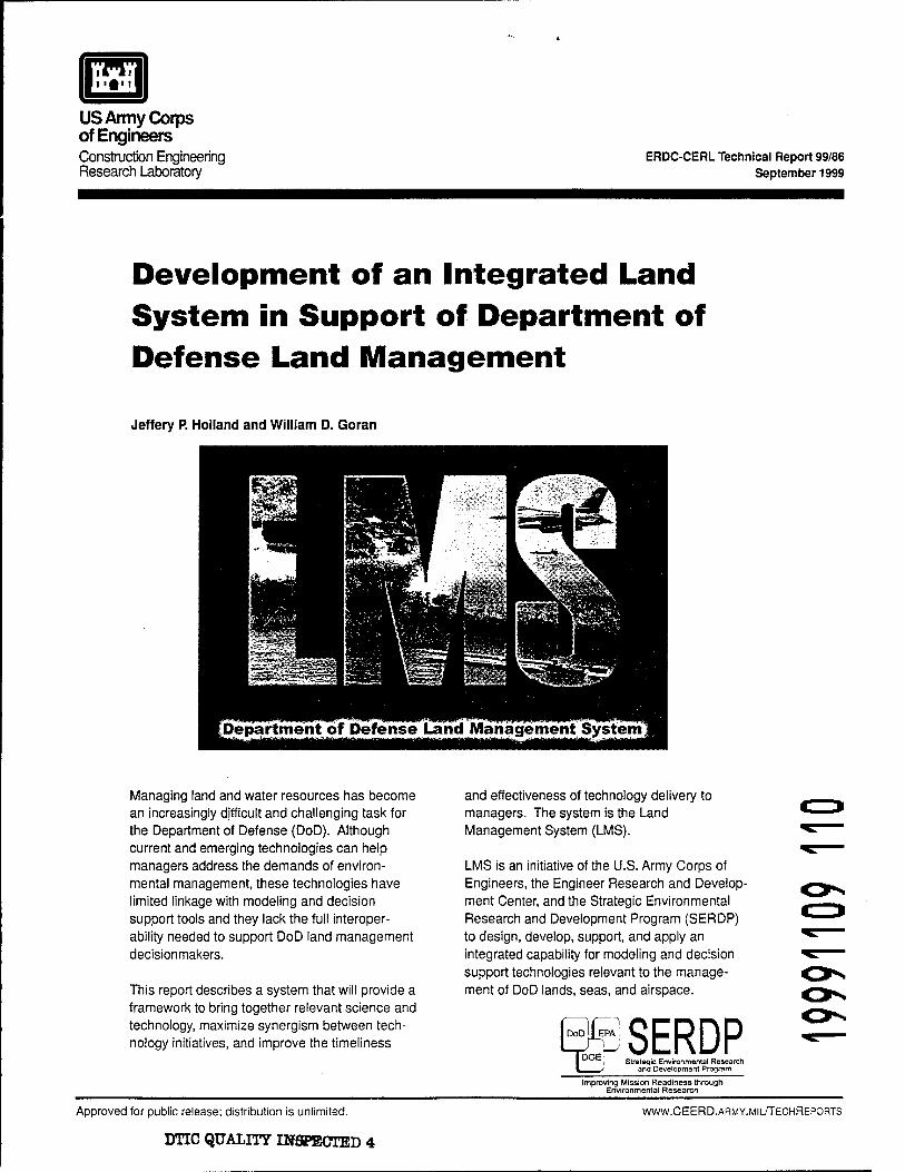
> ••>) US Army Corps of Engineers Construction Engineering Research Laboratory ERDC-CERL Technical Report 99/86 September 1999 Development of an Integrated Land System in Support of Department of Defense Land Management Jeffery P. Holland and William D. Goran M %=~~±m£.,. ,,: i^l^^lS^g-p^JB ^ S3 iüi^ji* ^Department of Defense Land Management System^ Managing land and water resources has become an increasingly difficult and challenging task for the Department of Defense (DoD). Although current and emerging technologies can help managers address the demands of environ- mental management, these technologies have limited linkage with modeling and decision support tools and they lack the full interoper- ability needed to support DoD land management decisionmakers. This report describes a system that will provide a framework to bring together relevant science and technology, maximize synergism between tech- nology initiatives, and improve the timeliness and effectiveness of technology delivery to managers. The system is the Land Management System (LMS). LMS is an initiative of the U.S. Army Corps of Engineers, the Engineer Research and Develop- ment Center, and the Strategic Environmental Research and Development Program (SERDP) to design, develop, support, and apply an integrated capability for modeling and decision support technologies relevant to the manage- ment of DoD lands, seas, and airspace. dSERDP i Strategic Environmental Research > and Development Program Improving Mission Readiness through Environmental Research Approved for public release; distribution is unlimited. DTIC QUALITY DJSPECTED 4 WWW.CEERD.ARMY.MIL/TECHREPORTS
Transcript of Development of an Integrated Land System in Support of Department of Defense Land ... US Army Corps...
>■••>)
US Army Corps of Engineers Construction Engineering Research Laboratory
ERDC-CERL Technical Report 99/86 September 1999
Development of an Integrated Land System in Support of Department of Defense Land Management
Jeffery P. Holland and William D. Goran
M %=~~±m£.,. ,,: i^l^^lS^g-p^JB ̂ S3 iüi^ji*
^Department of Defense Land Management System^
Managing land and water resources has become an increasingly difficult and challenging task for the Department of Defense (DoD). Although current and emerging technologies can help managers address the demands of environ- mental management, these technologies have limited linkage with modeling and decision support tools and they lack the full interoper- ability needed to support DoD land management decisionmakers.
This report describes a system that will provide a framework to bring together relevant science and technology, maximize synergism between tech- nology initiatives, and improve the timeliness
and effectiveness of technology delivery to managers. The system is the Land Management System (LMS).
LMS is an initiative of the U.S. Army Corps of Engineers, the Engineer Research and Develop- ment Center, and the Strategic Environmental Research and Development Program (SERDP) to design, develop, support, and apply an integrated capability for modeling and decision support technologies relevant to the manage- ment of DoD lands, seas, and airspace.
dSERDP i Strategic Environmental Research
> and Development Program
Improving Mission Readiness through Environmental Research
Approved for public release; distribution is unlimited.
DTIC QUALITY DJSPECTED 4
WWW.CEERD.ARMY.MIL/TECHREPORTS

The contents of this report are not to be used for advertising, publication, or promotional purposes. Citation of trade names does not constitute an official endorsement or approval of the use of such commercial products. The findings of this report are not to be construed as an official Department of the Army position, unless so designated by other authorized documents.
DESTROY THIS REPORT WHEN IT IS NO LONGER NEEDED
DO NOT RETURN IT TO THE ORIGINATOR

i"i
US Army Corps of Engineers Construction Engineering Research Laboratory
ERDC-CERL Technical Report 99/86 September 1999
Development of an Integrated Land System in Support of Department of Defense Land Management
Jeffery P. Holland and William D. Goran
Managing land and water resources has become an increasingly difficult and challenging task for the Department of Defense (DoD). Although current and emerging technologies can help managers address the demands of environ- mental management, these technologies have limited linkage with modeling and decision support tools and they lack the full interoper- ability needed to support DoD land management decisionmakers.
This report describes a system that will provide a framework to bring together relevant science and technology, maximize synergism between tech- nology initiatives, and improve the timeliness
and effectiveness of technology delivery to managers. The system is the Land Management System (LMS).
LMS is an initiative of the U.S. Army Corps of Engineers, the Engineer Research and Develop- ment Center, and the Strategic Environmental Research and Development Program (SERDP) to design, develop, support, and apply an integrated capability for modeling and decision support technologies relevant to the manage- ment of DoD lands, seas, and airspace.
SERDP Strategic Environmental Research
and Development Program
Improving Mission Readiness through Environmental Research
Approved for public release; distribution is unlimited. WWW.CEERD.ARMY.MIL/TECHREPORTS

CERL TR 99/86
Foreword
This study was conducted for the Strategic Environmental Research and Devel- opment Program (SERDP) under Work Unit CS-1088, "Land Management Sys- tems." The technical monitor was Dr. Robert W. Hoist.
The work was performed by the LMS Special Project Office, which is a virtual organization established within the U.S. Army Engineer Research and Develop- ment Center (ERDC). Mr. William D. Goran, located at the Construction Engi- neering Research Laboratory (CERL) in Champaign, IL, is the LMS Director; Dr. Jeffery Holland of the Coastal and Hydraulics Laboratory (CHL) at the U.S. Army Engineer Waterways Experiment Station (WES) is an Associate Director of the LMS Special Project Office. The ERDC technical editor was Gloria J. Wienke, Information Technology Laboratory.
The Director of CERL is Dr. Michael J. O'Connor.
DISCLAIMER
The contents of this report are not to be used for advertising, publication, or promotional purposes. Citation of trade names does not constitute an official endorsement or approval of the use of such commercial products. All product names and trademarks cited are the property of their respective owners.
The findings of this report are not to be construed as an official Department of the Army position unless so designated by other authorized documents.
DESTROY THIS REPORT WHEN IT IS NO LONGER NEEDED. DO NOT RETURN IT TO THE ORIGINATOR.

CERL TR 99/86
Contents
Foreword 2
List of Figures and Tables 5
1 Introduction 7
Background 7
State of Current Land Management Tools 8
LMS Objectives • 10
LMS Approach 12
Partnering 13
Objectives of this Investigation and Report 13
2 Functional and Conceptual Design of the LMS 15
Overview of LMS Functionality 15
LMS Conceptual Design 16
User Level 76
Modeling and Simulation Level 20
Data Level • 24
Basic Process Level 25
Utility of Web-Based Capabilities Within LMS 27
3 Establishment of LMS Protocols 29
Why LMS Protocols? 29
What are the Components of the Protocols? 30
How Will the Protocol be Developed? 31
4 LMS Prototype and LMS2000 Capabilities 33
LMS Prototype Functionality 33
LMS2000 Development Path 36
Develop Web-Based Framework 36
Modeling Tool Catalog/Advisor 37
Decision Support Tools 37
Evaluate Existing/Emerging Technology 38
Model Linkage and Programming Standards 38
LMS Model Suite 38
Predictive Uncertainty for LMS Suite 39

CERL TR 99/86
Employ/Establish Data/Metadata Standards 39
Common Data Storage Formats 39
5 Future LMS Versions and Considerations for Their Development 40
Proposed Development Schedule for Future LMS Versions 40
Considerations for Future LMS Development 42
Additional LMS Development Issues 43
Applicability of the LMS Across the Tri-Services 43
Applicability of LMS to DOE, EPA, and Other Agency Requirements 44
LMS Development Review 44
Technology Transfer 46
6 Summary and Recommendations for LMS Investment 48
Plan Summary — Next Steps for LMS 48
Recommendations for Relationship Between LMS Development and SERDP 49
References 51
Acronyms and Programs 52
Distribution : 54
Report Documentation Page 55

CERL TR 99/86
List of Figures and Tables
Figures
1 Different tools required by land managers 8
2 Comparison of land management issues between Army Civil Works and military sites 11
3 Major LMS development components 12
4 LMS conceptual levels 17
5 Schematic of web-based LMS functionality 28
Tables
Table 1. LMS2000 functionality. 36
Table 2. Proposed functionality of future LMS versions 40

CERL TR 99/86
1 Introduction
Background
Managing land and water resources has become an increasingly difficult and challenging task. Federal land and water resource managers face many new legislative requirements; inputs from increasingly sophisticated and often con- flicting interest groups; and demands to accurately project and evaluate the costs, benefits, options, and potential short term, long term, and cumulative con- sequences of any proposed management actions. In particular, the Department of Defense's (DoD's) Civil Works and military land management challenges en- courage the development of an integrated modeling/decision support environ- ment capable of simulating atmospheric-surface water-groundwater connectivity, flux interchange with the landscape, and the impacts of anthropogenic activities on ecological communities/habitats. DoD's land management challenges include
the need to:
Integrate multiple uses of lands and water resources Sustain mission use of training and testing ranges Clean and rehabilitate contaminated sites Restore aquatic and upland ecosystems Manage noise propagation Partner with stakeholders in ecosystem and watershed planning and man- agement Evaluate proposed activities on wetlands (permitting) Manage coastal zone, watershed, and riverine resources Conduct dredging operations Assess chemical and biological threats and risk pathways.
Note that these challenges are multi-disciplinary in nature and, in many cases, represent concerns applicable to the Departments of Interior, Energy, and Agri- culture, the Environmental Protection Agency, and other agencies.

CERL TR 99/86
State of Current Land Management Tools
Current and emerging technologies offer many capabilities to help managers ad- dress these difficult demands — such as geographic information systems (GIS)*, remote sensing, landscape process modeling and simulation, group collaborative forums and conferencing, expert systems, multi-dimensional visualization tools, decision support systems, and web-based data mining tools (Figure 1). Examples of DoD capabilities that integrate multiple technologies include the DoD Groundwater Modeling System, the Integrated Dynamic Landscape Analysis and Modeling System (IDLAMS), and the Predictive System for Environmental Assessment (PSEA). These systems have been developed through a combination of funds (including funds from the Strategic Environmental Research and Devel- opment Program, SERDP). The combined user community world-wide for these systems is in the thousands. Yet, these systems have only limited linkage with ecological modeling and decision support tools, and lack the full interoperability needed to support DoD land management decisionmakers.
Figure 1. Different tools required by land managers.
* A list of acronyms and models/programs is provided after the References.

CERL TR 99/86
Additionally, SERDP has invested, or is investing, in multiple ecosystem man- agement/modeling tools. These investments include the following:
Ecological Modeling for Military Land Use Decision Support (CS-758) Integrated Dynamic Landscape Analysis and Modeling System (CS-new) Assessment and Management of Risks to Biodiversity and Habitat (CS-241) Strategic Natural Resource Management Methodology (CS-373)
• Threatened, Endangered, and Sensitive Species (CS-507) • Risk Assessment Framework for Natural and Cultural Resources on Military
Training and Testing Lands (CS-1054) • Analysis and Assessment of Military and non-Military Impacts on Biodiver-
sity: a Framework for Environmental Management on DoD Lands using the Mojave Desert as a Regional Case (CS-1055)
• Error and Uncertainty for Ecological Modeling and Simulation (CS-1096) • Ecological Modeling and Simulation using Error and Uncertainty Analysis
Methods (CS-1097) • Predicting the Effects of Ecosystem Fragmentation and Restoration: Man-
agement Models for Animal Populations (CS-1100) • Improved Units of Measure for Training and Testing Area Carrying Capacity
(CS-1102) • Terrain Modeling and Soil Erosion Simulation (CS-752) • Fiscal Year 2000 (FY00) Statements-of-Need CSSON-00-01, "Riparian Zone
Rehabilitation to Restore Terrestrial and Aquatic Ecosystem Functions," and CSSON-00-03, "Ecological Disturbance in the Context of Military Land- scapes"
Additionally, there are past and ongoing SERDP investigations, including those in other areas (e.g., "Development of Simulators for In-Situ Remediation Evalua- tion, Design, and Operation," SERDP Project CU-1062) that represent compara- ble investments in environmental quality modeling and simulation technology.
While there is great potential for these technologies to help land and water re- source managers, they currently are disconnected pieces that need to be blended together into an integrated framework to achieve their highest productivity. This need is further amplified when one considers the plethora of environmental quality modeling/decision support tool developments within the U.S. Army (e.g., the Fort Hood Avian Simulation Model, the Ecosystem Dynamic Simulation Model, etc.), and by many other researchers (e.g., the Modular Modeling System and the Forest Vegetation Simulator by agencies within the Department of Inte- rior; the Spatial Modeling Environment by the University of Maryland; SWARM by the Santa Fe Institute) that represent potentially excellent, but unintegrated, resources in support of DoD land managers. The U.S. Army Corps of Engineers

10 CERL TR 99/86
model catalog can be found on the Land Management System (LMS) web site (http://wvyw.denix.osd.mil/LMS) under Tools Catalog (Westervelt 1998; Holland 1998). This web site provides additional information on many computational
tools.
LMS is an initiative of the U.S. Army Corps of Engineers (USACE) Engineering Research and Development Center (ERDC) to design, develop, support, and ap- ply an integrated capability for modeling and decision support technologies for applications relevant to the management of DoD lands, seas, and airspace. The concept for LMS evolved from extensive experience of the USACE laboratories (the ERDC) in providing numerical models and computational systems to Civil Works land and water resource managers at military Tri-Service installations
and to the Army Corps of Engineers.
LMS Objectives
The first objective of LMS is to provide a framework that brings together rele- vant science and technology to DoD land managers in a more complete and re- sponsive manner. The framework involves focusing, shaping, and integrating existing science and technology (S&T) investments toward common approaches and objectives, and designing an evolutionary and scalable computational envi- ronment that accommodates computer-based technologies emerging from these S&T investments. LMS is not a new funding line or program. Rather, it is a strategy to extend the value of existing diverse investments in science and tech- nology across the DoD into a more coherent package, identifying clear paths for product development, avoiding duplicate investments in delivery systems, and strengthening the teaming between scientists and managers. The LMS devel- opment represents both a process for accomplishing these objectives, and a prod- uct that delivers iterations of the results of this process.
A second objective of the LMS development is to maximize synergism between military and Army Civil Works technology initiatives. The USACE research laboratories serve military Tri-Service installation faculties and Army Civil Works land and water resources projects decisionmakers. These different user communities operate using different appropriations, report through different chains, and serve different national needs. Although specific mission uses differ widely between these projects/installations, resource management concerns are remarkably similar as illustrated in Figure 2.
LMS is designed to provide a more explicit way to achieve maximum synergism between DoD-wide technical investments supporting installation land managers

CERL TR 99/86 11
and Army Civil Works land and water resource managers. While programmed funding streams still are separate, LMS straddles these domains and LMS prod- ucts and expertise will serve both user communities.
Common Ground Land/Water Management Issues
Army Civil Works M ilitary Installations 24 Million Acres 25 Million Acres
Managing Managing Rivers, Reservoirs, Channels, Training Areas, Testing Ranges,
Watersheds Installations
Sustaining Mission Use Managing erosion & sedimentation
Sustaining Mission Use Managing erosion & sedimentation
processes Protecting sensitive species and sites Preserving biodiversity Involving stakeholders
processes Protecting sensitive species and sites Preserving biodiversity Involving stakeholders
Figure 2. Comparison of land management issues between Army Civil Works and military sites.
The third objective of the LMS development is to improve the timeliness and ef- fectiveness of technology delivery into land management business processes. In- vestments in technology have traditionally had a long time lag between problem identification by user communities and the infusion of new solutions that effec- tively address the problem in the user's business environment. There are many reasons for these time delays, and much variability in the timeframe between identifying the problem and delivering the solution. The creation of a common computational framework for land management decisionmaking, applicable across differing (but related) user communities within DoD, will streamline and focus technology delivery by:
1. creating a common, single point-of-entry from which DoD resource managers can access the key technologies needed for land management and decision support
2. developing a set of protocols for model-to-model linkage, and model-to-data con- nectivity, so that new technology investments in modeling and simulation, basic science, and information technology will seamlessly mesh with new data collec- tion, assimilation, and management activities at the installation level
3. establishing a technology base that, by design, will grow naturally as market- place technology advancements (such as in GIS, networking, computing, and new basic science) occur. This, in turn, provides DoD with high-leveraged improve- ments at minimal cost to the warfighter.

12 CERL TR 99/86
LMS Approach
Development of the LMS involves three main components: (1) establishing the LMS Protocols, (2) developing iterative versions of the LMS, and (3) the LMS Demonstration Program (Figure 3). The LMS Protocols provide common proce- dures for linking existing computer-based tools and for the development of new tools. The LMS versions refer to a series of evolving software releases (starting with LMS2000) that provide land management modeling and decision support capabilities to users. The Demonstration Program relates to site-specific field testing, validation, and implementations of LMS. To guide these LMS compo- nents, the ERDC has established an LMS Special Project Office. The Special Project Office has, in turn, created three teams: one to focus on the overall framework for LMS (the integration team) and two others focused on engaging end users in identifying problems and demonstrating LMS products. Primary demonstration sites are Fort Hood, TX, three sites (Pool 8, Redwood Basin on the Minnesota River, and Peoria Lake) on the Upper Mississippi River System, and Marine Corps Air Ground Combat Center at Twentynine Palms, CA. The lead- ers of the demonstration teams serve as members of the integration team, and the requirements for the demonstrations provide both inputs to help frame inte- gration priorities and an immediate context to test and demonstrate capabilities. The activities of the integration team (including the development of the LMS and the establishment of its protocols) are stressed in this report. More complete in- formation on the LMS Special Project Office, the administrative and technical structure and staffing of the LMS development within USACE, and the LMS Demonstration Program can be found in Goran et al. (1999).
Military Demonstrations
Other Users Army Civil Works Demonstrations
\ S
LMS Versions (2000+)
Integration Efforts
LMS Protocols
■7*+ :—V
/
JL Military Technology
Programs
\
Civil Works Technology Programs
Partnered Programs (Industry, Other Agencies, Academia)
Figure 3. Major LMS development components.

CERL TR 99/86 13
Partnering
A key to the overall LMS development strategy is the focused, purposeful techni- cal partnering with other research organizations. For example, current LMS
partners include:
• DoD: USACE labs, district offices (e.g., St. Paul, Rock Island), Institute for Water Resources, and Hydrologie Engineering Center, Naval Surface Warfare Center-Dahlgren, Army Center for Health Promotion and Preventative Medi- cine, High Performance Computing Modernization Program, Army Environ- mental Center, Army Research Office
• Department of Energy: Argonne, Oak Ridge, Pacific Northwest, and Law- rence Livermore National Laboratories
• Environmental Protection Agency: National Exposure Research Laboratory • National Resource Conservation Service • Department of Interior: U.S. Geological Survey, Fish and Wildlife Service,
and National Park Service • State Resource Agencies • Academic Partners: Syracuse University, Brigham Young University, Univer-
sity of Illinois, Texas Regional Institute for Environmental Studies (Sam Houston State University), Colorado State University, University of Con- necticut, University of Minnesota, and the University of Texas-Austin
• Industry Partners: Environmental Systems Research Institute, the Open GIS Consortium, and Pacific Meridian.
This focused partnering provides for leveraging and acceleration of the best of external research and development while maintaining the requisite level of criti- cal in-house mass to ensure that DoD is a "smart" technology investor. Note that the DoD partnering has only just begun and is anticipated (based on past experi- ences with USACE-developed modeling systems whose user bases include high levels of Tri-Service users) to increase dramatically over the next few years.
Objectives of this Investigation and Report
The objectives of this report are to: (1) document the functional requirements and conceptual design of a Land Management System for use by DoD in support of environmental quality stewardship and overall installation readiness, (2) pre- sent the functional capabilities of a prototype LMS, (3) describe the planned de- velopment path for the LMS over the next several years, and (4) recommend po- tential investments SERDP could make in the development of the LMS.
14 CERL TR 99/86
The findings reported herein represent the results of an investigation jointly funded by the U.S. Army Corps of Engineers and SERDP (under the auspices of Project CS-1088). It is noteworthy that the LMS development is of such a col- laborative nature that even its design and technical scope have been conducted in a partnered fashion between SERDP, USACE, and other partnering organiza- tions.
This report first documents the conceptual components of the LMS's functional design in Chapter 2. Chapter 3 presents the need and plans for development of standard protocols to facilitate overall LMS connectivity and model-to-model in- terchange. Chapter 4 overviews the existing LMS prototype systems, its capa- bilities, and the capabilities to be fielded in LMS2000 at the end of FY99. Chap- ter 5 provides details of proposed future LMS versions, and considerations that must be tackled as part of future LMS development. Chapter 6 then provides recommendations for investment in these future developments.

CERL TR 99/86 15
2 Functional and Conceptual Design of the LMS
Overview of LMS Functionality
DoD's land management challenges of the next decade encourage the develop- ment of an integrated modeling environment capable of simulating atmospheric/ surface water/groundwater connectivity, flux interchange with the landscape, and the impacts of anthropogenic activities on ecological communities/habitats. Such a simulation capability would need to be framed in a holistic, network- based computational environment to allow access to models and data sources existing and/or executing on remote computing platforms. Specific protocols that establish and broker standardized, seamless links between database/model and model/model connections are required. Both short-term (e.g., real time to a few days) and long-term (e.g., years to decades) analyses would also be required. To this end, the following functionality is needed in the development of a computa- tionally-based land management/decision support capability:
1. Coupling of surface water, atmospheric, groundwater, and terrestrial modeling tools, both serially (indirect) and dynamically (direct). The LMS will be built upon a combination of the modeling and simulation (M&S) foundation within the USACE labs and SERDP-funded developments, but will by design integrate nu- merous ecological models and analysis tools from partnering organizations. Dy- namic coupling will require development of numerical methods for handling dif- fering time and spatial scales associated with surface water hydrodynamics; watershed runoff; infiltration; atmospheric transport; subsurface flow and (often) highly-nonlinear, multi-component transport; and their interactions with resi- dent ecological communities. Standards for linkage of these diverse models will also be established to facilitate indirect coupling of these models when such a coupling is adequate.
2. Incorporation of the integrated modeling tools from item 1 within a comprehen- sive, web-based, modular modeling system. Interoperability with other DoD management systems will be stressed. Network-based modeling support will be provided within the system. This capability will allow access to remote computing platforms (including DoD high performance computing resources), decentralized databases, and collaborative technical support over network

16 CERL TR 99/86
services. Further, the LMS will leverage commercial-ofF-the-shelf (COTS) marketplace software developments, particularly in the areas of web browsers and standardized data protocols (such as the Open Geospatial Database Interchange [OGDI]). Such leveraging will facilitate updating and standardization of the LMS as the marketplace advances while mamtaining current local-user systems access and use.
3. Incorporation of uncertainty and risk into the LMS to support risk-based design and natural resources decisionmaking. This capability will allow presentation of data, modeling and simulation results, alternative evaluation, and tradeoff analyses as functions of technical viability, ecological risk, costs, and regulatory
compliance. 4. Integration of decision support tools to facilitate the interpretation and dissemi-
nation of modeling and simulation results, data manipulations, etc., in a manner amenable to differing users at differing levels of the land management process. This capability will include the development of linkages to key DoD business pro- cess systems that are external to LMS (e.g., the Army Training and Testing Area Carrying Capacity [ATTACC] model, or the Civil Works Water Control Data Sys- tem), and to certain classes of local-user systems (e.g., GIS and databases) al- ready existing at user sites.
LMS Conceptual Design
LMS makes technical capabilities, expertise, and technical information readily available to the DoD user community in support of land management. The sys- tem is organized with four levels (Figure 4), each with a suite of functions, all accessible through a web-empowered user interface from the user's desktop com- puter. A general description of the capabilities to be delivered within each of these LMS levels over the system's proposed 6-year development life cycle is pro-
vided below.
User Level
The User Level is the entry point to all LMS services, both local to the user's ma- chine and on various other servers/computing platforms to which the user has access. The focus of this level is the web-based, network-empowered human/ computer interface to the LMS (hereafter referred to as the user environment). This environment is the one the user will conduct all LMS activities within, and from which all LMS services will be provided. The user environment will have a single, consistent look and feel on personal computers running Windows 95 and NT and on UNK workstations running X-Windows (with primary emphasis on the latter two operating environments due to the ongoing transition of Windows

CERL TR 99/86 17
toward an NT basis). The user environment will be developed based on a combi- nation of marketplace standards (COTS browsers, Java, Windows, etc.) to ensure its portability and to increase its natural maturation.
Provides
User Level
Data Level
Basic Process Level
-Access to Resources - Navigation Tools -Visualization Capabilities -Scoping - Collaborative Tools
- Modeling Systems (numeric) - Conceptual Modeling Tools - Uncertainty Analysis Tools - Model Integration Guidance
- Metadata - Data Locator Tools - Common Data Formatting - Parameter Database
-Gaps Analysis - Process Integration Mapping - Programs & Projects Listing
Figure 4. LMS conceptual levels.
The LMS will be developed with a common database, standard interchanges with existing databases and geographic information systems (through OGDI and Open Geodata Interoperability Standards [OGIS]). Three-dimensional visualiza- tion and animation (with output formats that are common to Windows environ- ments) will be resident. Additionally, the system will have a significant level of decision support, and will have linkages to external decision support tools such as ATTACC, the USACE Water Control Data System, the Integrated Training Area Management (ITAM), and others. Modeling and simulation user aids, and collaborative technical support will also be provided to the users throughout the LMS development lifecycle.
The ultimate product to the user from the LMS, however, is the integration of advanced modeling simulation, seamless data access, tradeoff analyses convey- ing risk and costs of activities, and presentation mechanisms in formats under- standable to decisionmakers and stakeholders in a manner never before avail- able. The individual tasks envisioned under the User Level over the 6-year development cycle of the LMS are presented in the following paragraphs.

18 CERL TR 99/86
Web-based LMS framework. Develop single, comprehensive access to all LMS services through web-based
computational environment. Develop single human/computer interface. Develop framework from combination of COTS software (such as web brows- ers, UNK, Windows NT and 95, if required), and Java to allow maximized flexibility and portability across computing platforms. Provide network access to the LMS modeling and simulation suite, data- bases, and multiple computing platforms (including high performance com-
puting [HPC] resources within DoD). Integrate navigation aids to facilitate user access to LMS services. Provide for both network-based and localized execution of LMS. Provide for use of legacy systems by local users.
LMS visualization tools. Incorporate full three-dimensional (3D), time-varying visualization and ani- mation tools within the web-based computational environment. Make best use of existing capabilities within "legacy" (preexisting) systems as
appropriate. Include ability to use local user systems as needed. Develop ability to output visualization capabilities directly transportable to video formats (AVI, MPEG) for users ranging from managers to the general
public. Include "on-the-fly" visualization capability to allow the user to watch pro- gression of simulations, and to modify the inputs to those simulations, as a "person-in-the-loop" for management scenario evaluation.
Decision support tools. Incorporate decision support tools within the LMS computational framework to allow managers to assess risk and worth of given management scenarios, to assist in decisionmaking, and to provide output to external management
systems employed by users. Build specific linkages to ITAM, ATTACC, IDLAMS, Range and Facility Management Scheduling System (RFMSS), and the USACE Water Control
Data System as a beginning. Develop report generation capabilities in formats suitable to meet environ- mental reporting requirements. Leveraging work units and systems such as the Decision Analysis System (developed by White Sands Missile Range). Include web-based technical collaboration and support features to facilitate long-distance, multi-stakeholder collaboration in modeling analysis and con- sensus making as technological advances permit.

CERL TR 99/86 19
Indices of land management effects.
• Develop indices which, when visualized, convey the "worth" of a given man- agement activity to decisionmakers, technical specialists, etc.
• Tie these indices to the modeling and simulation tools within the LMS (at the cause-and-effect level whenever possible).
• Develop surrogates for environmental endpoints for which the level of science is not sufficient for modeling and simulation, or for which extended ecological modeling is not needed (e.g., use of carrying capacity or erosion as surrogates for habitat loss).
Modeling tool catalog.
• Develop web-based catalog of modeling tools that support overall land man- agement.
• Leverage evaluation of existing technology work (described later in the Mod-
% eling and Simulation Level) to facilitate entries into the catalog. • Provide for on-line documentation, queries of applicabilities and limitations
of given models and screening tools, and tutorials for certain models, all ac- cessed through the World Wide Web (Internet).
• Include documentation of model uses and "lessons learned" where available, through a knowledge-based system capable of helping users in model selec- tion.
Modeling restoration alternatives. Several land and aquatic environment resto- ration and rehabilitation techniques exist that may be useful in differing site- specific situations. This work will build on the modeling suite capabilities to provide mechanistic models for assessing the efficacy of remedial/restoration al- ternatives. This work will be tied directly to that listed in the next paragraph to provide economic worth and technical effectiveness of restoration techniques.
Economic and risk analysis.
• Integrate into the LMS framework ecological risk assessment paradigms and economic analysis of management scenarios as a function of environmental endpoint in conjunction with work in the Modeling and Simulation Level.
• Develop methods to output tradeoff analysis showing relationship between given level of DoD activity, risk to environment, and costs to mitigate said risk and/or restore environment after conduct of activity.
• Build connection between risk, economics, and environmental currencies such as maneuver impact mile equivalents.
• Leverage ongoing SERDP investments as part of this effort.

20 ' CERL TR 99/86
Management scenario development tools. • Build help aids for LMS users that support their development of differing
management alternatives to evaluate/simulate/implement. • Include knowledge-based system of "lessons learned" to help with initial
screening of management alternatives for similar site uses and environ-
mental endpoints. • Integrate artificial intelligence capabilities to archive simulated and observed
causes and effects as means of steering management trajectories and reduc- ing the set of possible solutions.
Assessing worth of resources to stakeholders. A key component of optimal re- source allocation in a multi-user environment is the assessment of the worth of the given resource(s) to differing stakeholder groups. Separate from, but related to, tradeoff analysis, there is a need to provide a pseudo-quantitative means (via indices) of the worth differing stakeholders place on different resource allocation plans. Such means can be established through the use of methods such as fuzzy logic or goal-oriented optimization to provide a stakeholder response matrix for different management decisions. This matrix will be a living response as stakeholders modify their perceptions of different management scenarios and tradeoffs, and as new data are integrated into decisionmaking.
Technology support. The intent is to provide dedicated technical support staff for LMS users, centrally funded to support users up to 5 man-days (plus travel and per diem if field site support is required), at "no cost" to the users. Based on extensive experience with other modeling systems, such support is absolutely essential to the effective use of the LMS. This support would be used in four subareas: (1) technical consultation to users, (2) system maintenance and cor- rection, (3) system dissemination complete with on-line tutorials, and (4) out- year, small-scale system enhancements. This effort would leverage the capabili- ties developed in the basic LMS computational framework work unit to provide consultation via networked services when this medium is deemed the most effec- tive manner for such support. Demonstration of the LMS versions would be con- ducted in conjunction with (and leveraged against) the military and Army Civil Works portions of the overall LMS development.
Modeling and Simulation Level
The Modeling and Simulation Level houses the suite of modeling tools, from simple screening tools to highly-advanced, three-dimensional models. Standard protocols and projection methods will be developed to allow M&S results to be interchanged seamlessly between models requiring linkage (e.g., hydrology mod- els and sediment models). Coupled modeling technology will be developed when
CERL TR 99/86 21
required by the process being simulated. An initial evaluation of extensive part- nering and applicable technology within and external to USACE will be con- ducted to ensure that the best of existing M&S is brought into the LMS suite. New models will be developed based on requirements from users, stakeholders, and from those needs arising from the LMS demonstrations.
The M&S Level activities will be closely coordinated with the Basic Process Level work to ensure expedited entry of new science and engineering knowledge into the LMS. Verification of M&S tools will be conducted primarily within the LMS demonstration projects. The tasks required for the M&S level are pre- sented in the following paragraphs.
Evaluate existing/emerging technology. Include in this evaluation:
SME, IDLAMS, EDYS, FHASM, WMS, GMS, SMS, SIMWE, RUSLE, PRISM, mod- eling development planned/ongoing/completed under SERDP and other programs, SWARM, HMS, RAS, military training footprint models (TUDM), ecological modeling ongoing outside DoD (DOI, DOE, EPA, USDA), COTS, and appropriate risk and eco- nomic models. Select the best of these for use in LMS.
Model linkage and programming standards.
• Establish inter-connectivity protocols of legacy models, and set standards for future model developments.
• Consider utility of various web-based constructs (e.g., Argonne National Laboratory's Dynamic Information Architecture System [DIAS], DoD's Higher Level Architecture, Syracuse University's WebFlow) and other M&S constructs as basis for the model-to-model linkages.
• Empower and standardize future model development, allowing for leveraging of externally-developed, internally-verified models deemed appropriate for LMS inclusion.
Initial LMS model suite. Several models are known to be viable for inclusion in the initial suite of models, directly, or after expansion of these models with sub- routines needed for LMS field applications. Linkages of these models are needed to support the field applications, and for development of the first two versions of the system. LMS-compliant versions of WMS, EDYS, RUSLE, ICBM, FHASM, TUDM, SIMWE, GMS, and SMS will be developed. The need to include atmos- pheric transport/deposition and precipitation forecast models in this initial suite will be evaluated. Possible initial linkages include: WMS-EDYS-RUSLE; ICBM- FHASM, and TUDM with one or both of the former. This work will be conducted in tandem with the work unit listed above and with the field application projects.
22 CERL TR 99/86
Conceptual model development environment. Often, conceptual models of the ecological endpoints at a given site are poorly developed or nonexistent. LMS users require the ability to develop more and more sophisticated conceptual models of the processes affecting their endpoints of concern in the absence of mechanistic modeling capabilities for the site. This work unit will make use of an ecological modeling environment, such as the Synthetic Modeling Environ- ment from the University of Maryland, to provide users with such an environ-
ment.
Multi-scale projection and connectivity. LMS simulations will often involve linkage of models with highly differing time and space scales and input require- ments. Beyond the standard linkage issues to be tackled, projection methods are needed to correctly and efficiently migrate information from one computational domain (e.g., off an unstructured grid) to another (e.g., structured grid) while maintaining the fundamental character of the physics being simulated. Simi- larly, it will be necessary to aggregate fine time-step information (e.g., from a hydrodynamic model having an hourly time step) to a much larger time scale (such as for a water quality or ecological model with monthly time steps).
Screening-level tools in M&S suite. Include number of "quick and dirty," zero- order tools/models, all simplified with minimal data input, for screening of alter-
natives and impacts.
Parameterization and Conceptualization Methods. Develop methods to effi- ciently parameterize models brought in to the LMS M&S suite. Parameteriza- tion is required for many legacy models as well as new developments. Link this capability to work described in the User Level to help users develop new or up- date conceptual ecological models in absence of site-specific or mechanistic mod-
els for given site.
Improved Modeling of Flow-Plant-Sediment Interactions. Nature provides direct feedback between rainfall, runoff, in-stream flow, sediment transport, plant cov- erage and disturbance, and the anthropogenic footprint for that landscape. However, the current state-of-the-art in erosion/deposition and hydrologic mod- eling over the landscape uncouples these processes. Research in this work unit will develop a dynamically-coupled modeling capability building off the success of recent SERDP work and military hydrology activities. The effort will also de- velop improved, long-term geomorphic modeling capabilities for predictions of future receiving water bathymetry over long (50-year) scenarios.
Fully-Coupled Surface Water - Groundwater - Watershed Modeling. The current state-of-the-art in this area is primarily uncoupled as well. However, work in the
CERL TR 99/86 23
DoD High Performance Computing Modernization Program is developing cou- pled flow and rudimentary transport capabilities in this area. This work will fully empower this capability at the basin, watershed, installation, or range scales for water quality and contaminant transport. Updates to watershed capa- bilities, such as modification of CASC2D to include two-dimensional modeling of receiving waters, will also be conducted. Improved simulation of wind-wave ef- fects will also be included.
Predictive Uncertainty for LMS M&S Suite. The predictive uncertainty associ- ated with each model within the LMS suite must be quantified as a required component before conducting uncertainty analysis or presenting results. Uncer- tainty bands will be provided for all LMS predictions, and will be used as a part of the risk assessment paradigm discussed in the User Level work unit on risk. Monte Carlo simulation capabilities will also be integrated into the LMS as part of this work unit. Ongoing SERDP-funded work will be leveraged in this inves- tigation.
Ecological Model Development. A number of new, or second-generation, eco- logical models are required. These include: dynamic habitat patch-type models, cryptobiotic process models for soils, differing fisheries models, improved succes- sional models for aquatic, grassland, and arid environments, zebra mussel mod- els, and enhanced models for nesting birds. These models will be developed us- ing LMS standards developed above, and will be leveraged significantly against the demonstration projects and basic science efforts being conducted outside USACE.
Vessel-Fluid Interactions. Movement of vessels, ranging from Navy carriers to navigation traffic to recreational craft, generates significant disturbances to the resident water body. These disturbances include wave formation, entrainment and eddy formation, mixing, scour, and sediment redistribution. These forces have the potential to affect aquatic habitats through aquatic macrophyte break- age, turbidity, burial, siltation, etc. These effects can, in turn, greatly modify the habitats and productivity of macrophytes, fishes, wading birds, arid water fowl. Hydrodynamic models capable of properly simulating the flow fields developed by vessel traffic will be developed and couple with existing and improved trans- port models to augment impact assessment.
New Process Science and Models into LMS M&S Suite. Leverage basic science work funded external to this work unit (e.g., from LMS demos, SERDP, partner- ing organizations) to update M&S suite capabilities in multiple areas in the out years (years beyond FY 2000). Significant enhancement of models in the M&S suite is expected, with the newest models developed using programming and

24 CERL TR 99/86
linkage standards developed in other parts of this work unit. Incorporate appro- priate new models, or develop new models as needed, into suite. Continue for
life of LMS development.
Verification of M&S Capabilities. Each of the LMS models, including those de- veloped externally, must undergo a hierarchy of verification testing to quantify reliability and predictive uncertainty. This effort will leverage the LMS demon- stration program and site-specific applications where possible to promote syner-
gism.
Data Level
Research and development for the Data Level will key on standardization of the data gathering, quality control (including automated flagging of questionable values), management, and manipulation of data from multiple sources (including network server locations, remotely-sensed data, and real-time data such as weather radar). Parameter databases for the M&S suite will be developed. Standards for model metadata, data interchange between databases and geo- graphic information systems, and linkages to remotely-sensed and real-time data will be used as available (e.g., the Tri-Services CADD/GIS standards) or proposed as needed. Significant partnering and leveraging, particularly through inter- agency coordination groups, will be conducted to expand the range of investment in this level. The tasks required for this level are presented in the following
paragraphs.
Data/Metadata Standards. This task will be conducted in conjunction with multiple Federal agencies (through Federal geospatial data coordination commit- tees), and specific DoD elements (e.g., the Tri-Service CADD/GIS Technology Center). Model-required data and parameters for models within M&S suite will be identified. Entities, attributes, and domains for models and data will be de- fined. These elements will be identified in a manner that is directly compatible with Federal geospatial standards (or will become the standards). Standard links between differing data types common to land management (e.g., DTED, NATO, ESRI, MGE, etc.) will be established. Marketplace activities to ensure that standards are seamless with new GIS and database developments in indus-
try (e.g., OGDI, OGIS) will be leveraged.
Distributed Database Indices and Access Tools. • Develop standard access capabilities for obtaining data from remote and dis-
tributed databases. • Evaluate potential for leveraging tools and methods from the USACE Water
Control Data System (WCDS), particularly the HEC DSS constructs.
CERL TR 99/86 25
• Develop connectivity to WCDS at a minimum; connectivity to remote data- bases will leverage the Data/Metadata Standards work unit in this section plus the first in the User Level.
• Establish seamless connectivity to numerous natural resources data types including species occurrence, distribution, and variability for fisheries, macro invertebrates, aquatic and terrestrial plants, migratory and resident birds,
and soil crust communities. • Provide for web-empowered connectivity to databases for digital elevation
models, bathymetry, land use and cover types, water quality and contami- nants, and historical flow record and precipitation data.
• Partner with commercial groups in this task.
Common Data Storage Formats. In concert with work previously described in this section, standards for data storage to be followed for all new or future LMS development and application activities will be established.
Linkage to Real-time and Remotely-sensed Data. Develop seamless connectivity to methods used by DoD and other agencies for collection, quality assurance, and dissemination of real-time and remotely-sensed data (including registry of aerial photography and satellite imagery). Provide efficient means for connecting to remote devices to pull such data as required. Provide direct link to precipitation forecasts, NEXRAD output, etc., on a real-time or near-real time basis.
Parameter Database for LMS Models. Develop a database, and establish link- ages to other existing databases, to provide users with bounds for model parame- ters used in past modeling investigations (including links to documentation of parameter estimates where possible). Allow users to query this database from the User Level. This capability will ultimately be quite extensive, housing pa- rameters for hydrologic, water quality, contaminants, hydrogeologic, and ecologi- cal simulation at a minimum.
Basic Process Level
Numerous processes (hydrologic, geomorphic, and ecological) have significant knowledge gaps that are of importance in DoD land management activities. These gaps severely decrease the worth of modeling and simulation by so wid- ening the uncertainty associated with any predictions as to render them mean- ingless in some cases. The investment that would be required to cover all this range is well beyond the LMS scope. The basic investment approach taken here is to seek to prioritize focused basic science being conducted in SERDP and by the Tri-Services. Leveraging of significant investments already ongoing within DoD, NSF, DOE, USDA, USGS, and other parts of Department of Interior is a
26 CERL TR 99/86
fundamental component of the effort required within the Basic Process Level as well. Note, however, that a desired product from such basic process science is developing a mechanistic process understanding that can be incorporated into the M&S suite, or into knowledge-based systems, within the LMS.
Presented below are several topics that are deemed candidates for basic science investigations. No effort is made to specify the funding level or duration of each investigation at this time.
• Scale Discontinuities between Hydrologie, Meteorological, Geomorphic, and Ecological Processes: Basic research investigation of scale, methods to prop- erly capture and link process of radically different scales for geophysical, hy-
drologic, and biological processes. • Sediment Transport Processes: With emphasis on cohesive mechanics, inves-
tigate effects of compaction and dewatering on sediment properties, and de- velop new transport formulations both overland and in-stream. In out years, investigate colloidal transport overland and in the subsurface as major factor governing contaminant transport.
• Current/Wave/Sediment/Plant Interactions: Investigate the significant in- teraction between vessel-generated waves, current, sediment transport and resuspension, and their attenuation and impact on aquatic plants.
• Vegetation Successional Processes: Need mechanistic cause-and-effect rela- tionships for successional patterns, and impacts of man thereupon, for grasslands, arid lands, aquatic environments.
• Military-Unique Footprint of Training and Testing: More mechanistic man- ner of assessing the actual impacts of training on vegetation, habitat, soil structure, certain ecological endpoints is needed. Include impacts of firing such as smokes, obscurants, chaff, noise, as well as training effects.
• Long-term Geomorphic Shaping Processes: Management of river basins and navigation channels to military installations requires improved understand- ing and prediction of the long-term effects of human activities and natural variability on the flow of the water body.
• Mechanisms Affecting Nesting and Migratory Birds: Need mechanistic proc- ess work for advanced models of bird behavior relative to DoD activities.
• Contaminant Fate and Transport Processes in Various Media: Leverage cleanup and fate and effects research for aquatic environment and soils. De- velop increased understanding of the interactions of contaminants due to at- mospheric-terrestrial-aquatic transport.
• Measurement Indices for Ecological Risk From Military Activities: Based on disturbance theory, develop improved ecological models and/or surro- gates/indices for use in land management.

CERL TR 99/86 27
Utility of Web-Based Capabilities Within LMS
Among the design criteria, none is perhaps more important to LMS's productive use than that of being "web-based." The use of the World Wide Web has become a phenomenon of commercial and social significance over the past few years. Over the next few years, as much broader-banded, long-distance networks be- come available commercially (through expanded capabilities from telecommuni- cations providers), and within DoD (through the DoD High Performance Com- puting Modernization Program's Defense Research and Engineering Network for example), the ability to access, manipulate, and display information over net- work resources will take additional strides forward.
At present, it is common within the land management community of DoD and other agencies for land managers to require digital elevation models, contami- nant fate and effects data, installation management information (e.g., location of training areas, firing ranges, roads, buildings, storage facilities, fuel depots, etc.), land cover and use data, and soils information. The addition of modeling and simulation results will further increase the number of and amount of data that these managers must assimilate. Further complicating this picture is the ever- expanding view of DoD installations and Army Civil Works projects as compo- nents of a holistic landscape that interacts at scales larger than the installation fence line or the high-water mark of the reservoir.
The data needed by land managers (including modeling and simulation results, which can be viewed as a data source for this discussion) are seldom resident on a single computer, or even at a single location. For example, digital elevation information may reside at the local installation or project, but these data often stop at the installation or project boundary. Topographic information, land use and cover, and soils data are all resident through connectivity to network servers of the USGS. Unclassified fate and effects data are available from several DoD and EPA databases, each again accessible through network queries. Equally, the execution of differing environmental quality modeling and simulation tools can be conducted on a variety of computing resources, ranging from personal com- puters to workstations to high performance computing resources, through remote network and dial-up connections. The ability of a highly-disparate group of us- ers, from range managers to modelers to senior management decisionmakers to productively access input and output data from environmental quality decision support systems is therefore contingent upon those systems facilitating near- seamless connectivity to remote data sources (or, for that matter, data residing on local-area networks within an installation or USACE district office). Ideally, the user would view "remote cyberspace" as nothing more than an extension of their local machine as shown in Figure 5.

28 CERL TR 99/86
A prototype of this network-empowered functionality has been achieved. The functionality of the LMS prototype is discussed in Chapter 4 of this report. However, it is clear from the development of this prototype that the establish- ment of a set of standard protocols for database/user, model/data, and model/ model connectivity is essential and fundamental to the realization of the web- based LMS. The importance of standard protocols would be evident if Figure 5 included arrows to all the data sources required by land managers in the course of their decisionmaking. A plan for establishing these protocols is overviewed in
Chapter 3.
kMulti-Piatform Modeling&
''Simulation
Figure 5. Schematic of web-based LMS functionality.

CERL TR 99/86 29
3 Establishment of LMS Protocols
Why LMS Protocols?
Establishing LMS protocols has two objectives: (1) improved interoperability be- tween computer-based tools, models, and decision support systems, and (2) im- proved representations of landscape processes and dynamics, especially across multiple landscape analysis domains (e.g., hydrology, ecology, noise propagation, socio-economic) that interact. The purpose of both of these objectives is to im- prove the efficiency, accuracy, and value of a user's landscape management and analysis decisions.
Protocols are needed simply because without agreed upon procedures, each tech- nology provider goes his or her own way. The result is that customers suffer - they either have to put the pieces together themselves, or work each piece in isolation. Users want landscape process models and decision support tools to fit together seamlessly without requirements for specialized code, translators, and procedures.
This fitting together also has multiple dimensions: LMS computational elements that are interoperable; a single user environment; common methods to interact with geo-based systems; and a set of common procedures for exchanges of data between system components and external databases and decision support sys- tems.
Landscape process representations should use procedures that facilitate process interactions between tools. This is a critical step in advancing a holistic under- standing of landscape phenomena. Conventional tools generally work in sequen- tial isolation, with no opportunity for process dynamics to be altered during a process run. Data are input to a process model, the model is run, then results are exported from this model to yet another model or geospatial system (e.g., geographic information system). But landscape processes dynamically interact across multiple processes and domains. As an example, man-induced effects within watersheds (such as military training, land use patterns) affect vegeta- tive cover in these areas. These effects, in turn, modify both runoff patterns from storm events and the associated erosion and sedimentation on the land- scape and its receiving waters. These altered hydrologic patterns, coupled with

30 CERL TR 99/86
ongoing man-induced effects, subsequently provide a feedback to vegetative growth and diversity, thereby again affecting hydrologic runoff and erosion/ sedimentation. Protocols for these model-to-model exchanges can help achieve more accurate process representations in models and decision support environ- ments. Ultimately, the protocols will help evolve common elements in future vi- sions of how to represent and analyze landscape dynamic processes, thereby driving the LMS framework for future technology investments.
What are the Components of the Protocols?
The LMS Protocols will be scalable and evolutionary. That is, the protocols must operate at multiple levels that allow varying degrees of involvement and compli- ance, and they must be designed to help shape and respond to the evolutionary forces (advances in COTS, hardware, networking, user interfaces, geospatial and temporal data models, and environmental quality modeling and simulation) that will impact LMS components and capabilities. A five-step or -level series of pro- tocols has been established for development of these protocols, with each step defined as follows:
• Level I - Registration. This level relates to identification of tools, and a common set of data (metadata) about these landscape related computer-based tools. This information is being encapsulated by the LMS team in a web- based database (the modeling catalog). A first version of this catalog (http://owww.cecer.army.mil/ll/landsimsurvey/homepage.html) has already been created, and has been populated with numerous tools. A second compo- nent of this "protocol level" is the model analysis, comparison, and "advisory" potentials of the catalogue. These analysis functions will help inform users of more advanced levels of the LMS, and will provide direct assistance to land managers in evaluating the applicabilities/limitations of differing computa- tional tools for their specific land management problems.
• Level II - Shared Assets and Procedures. This level includes linkages for ac- cess to common or shared resources (e.g., network computing or database as- sets) and linkages between systems and tools (e.g., linkages with legacy sys- tems, linkages with COTS). Essentially, this protocol level relates to interoperability of systems and input/output across these systems. The level must have multiple degrees of sophistication to empower the LMS, to evolve as interoperability options evolve. Note that developments at this protocol level will strongly engage both the COTS community and legacy system de- velopers/maintainers.
• Level III - Linkages Between Processes. This level relates to how data are exchanged between processes/models, and how these processes/models work

CERL TR 99/86 31
together. At this level, the exchanges are still sequential, rather than syn- chronized and dynamic. These linkages are necessary to develop suites of tools that address specific problems, so there will be multiple compatible suites of tools that are "level III compliant;" however, because different tool suites may house different models, there may not be full compliance between suites of tools at this level. Another issue to examine at this level is interac- tion between tools with different data models (e.g., raster versus network or vector data models). Level IV - Dynamic Linkages Between Processes. At this level, data are not just serially exchanged between computer-based tools, but the tools dynami- cally interact with model-to-model feedback. For example, changes in a wa- tershed (e.g., insertion of an erosion control structure or the effects of mili- tary training on vegetative cover) have a dynamic effect on sediment loading into the local receiving waters. The resulting erosional/sedimentation pat- terns subsequently affect vegetation, which together affect hydrologic runoff patterns in the watershed. The effect is not sequential but fully coupled, thereby requiring seamless model-to-model interactions. An important focus of this level is capturing dynamics across domains that are traditionally iso- lated (as a result of computational tools normally growing from specific knowledge disciplines and management stovepipes) in a cohesive, integrated framework. Level V - New Paradigm. This level is an evolutionary target that will influ- ence the future development of new technology. The primary purpose of this level, within the LMS Protocol framework, is to focus future technology in- vestments toward a fully interoperable, modular land management decision support environment that grows naturally as new marketplace and scientific advances are made. This level not only supports dynamic and synchronized interactions between tools, but it is an environment where landscape fea- tures, actions, relations, and processes are available as usable "objects" to address specific user-defined issues.
How Will the Protocol be Developed?
The above levels represent a conceptual framework for the protocol development process. In order to flesh out this skeleton, the LMS development team will tap into many communities of experts to aid the LMS team in drafting, reviewing, revising, evaluating, and testing these protocols. These communities include: (1) landscape related computer-based tool developers, (2) legacy and new system developers, maintainers, and users, (3) commercial technology providers, such as GIS vendors (primary through consortia such as the Open GIS Consortium), the Tri-Services GIS/CADD Center, and the HQUSACE Architecture 2000 initiative,

32 CERL TR 99/86
(4) technology program managers and advisors who influence the output re- quirements from landscape related technology programs, and (5) information technology and standards organizations within USACE and across the partici- pating services and agencies that will weave these protocols into their business
processes.
There will be a highly structured process for protocol management, so that all participants in the process can easily read the current protocol and react to both the protocol and to comments about the protocol. Two primary steps will be taken to accomplish this - one, the assignment of a protocol manager, who will keep track of versions, synthesize comments, and ensure that all voices are in- cluded in the process. Second, the protocol manager will use web collaborative tools to publish protocols, manage review comments, solicit interactions between commenting persons, and keep records of the entire process.
To manage this process, the LMS development team will develop sets of draft protocols for each Protocol Level, and these protocols will be reviewed at a series of reviews that engage the above communities in order to evaluate the protocol procedures from multiple perspectives.
After the initial protocol drafts and reviews, the protocols will be published in forums beyond the web that involve scientific peer review. Publication will help ensure that the protocols get wide exposure and critical peer review from the ap- propriate science and information technology communities. Presentations will also be given, at multiple organizational and scientific forums, to enhance this same wide exposure and critical review.
As the protocols are being reviewed, they will also be tested through application in the LMS. LMS versions and applications at LMS demonstration sites will provide the critical testbeds for the LMS protocols. Feedback from these test- beds (which should be mirrored by partnering organizations) will help evolve the protocols and will facilitate the credibility needed for their use and acceptance by the user and regulatory communities alike.
CERL TR 99/86 33
4 LMS Prototype and LMS2000 Capabilities
LMS Prototype Functionality
To evaluate the proposed conceptual design of the LMS, a prototype LMS was developed. This prototype was first demonstrated to a combination of SERDP, USACE, and other personnel in November 1998. The prototype combines web- based data access, watershed process modeling (running in combination on the local user's computer and on a selectable remote computer), and visualization, all accessed from a single user environment built on Java, an industry-standard programming language. Connection of these component parts into a cohesive LMS prototype was achieved through use of WebFlow, developed by Syracuse University, http://www.npac.syr.edu/users/hauptAVebFlow/demo.html. and lever- aged through the auspices of the DoD High Performance Computing Moderniza- tion Program's (HPCMP) Major Shared Resource Center at the U.S. Army Engi- neer Waterways Experiment Station (WES, now part of ERDC). WebFlow is a programming paradigm that provides access to a mesh of Java servers, running servlets, to manage and coordinate distributed computations and data exchange. Refer to the Northeast Parallel Architectures Center at Syracuse University's website for additional details on WebFlow.
The LMS prototype was developed in the Windows NT environment. This was done because NT offers the most straight-forward, portable operating environ- ment presently available that allows for multiple computational tasks to be per- formed concurrently. The LMS prototype has the following capabilities:
• A web-based data wizard that accesses remote USGS and National Resource Conservation Service (NRCS) webservers to obtain digital elevation models (DEMs), land use and cover, and soils data for the entire continental United States. This wizard is launched from the LMS user interface. Selection of data for a particular portion of the United States is done graphically by clicking first on a particular state (or states), then selecting a portion ofthat region through siting a point-and-drag rectangular box. The key aspect of this wizard is illustrated by the point that downloading a 1:250,000 DEM, which used to require approximately ten different operations to complete,

34 CERL TR 99/86
requires three operations in the LMS prototype. Further, the actual download of the DEMs is accomplished in the background as a concurrent operation (thread or task), allowing the user to continue using her/his local computer for other activities during the download. The ability to launch the Watershed Modeling System (WMS; Holland 1998), which resides on the local machine, from the prototype in its native, fully- functional user environment. Such a capability illustrates the ability of the LMS prototype to provide the user a value-added environment by directly ac- commodating legacy or local land management tools (such as existing GIS re- sources) while providing access to other models and databases. Further, be- cause the WMS is presented to the LMS user in its original form, the user is able to employ the WMS within the LMS just as he/she would have in a stand-alone mode. This also illustrates an equally important aspect of the LMS development in that the WMS is treated by the LMS as a linked, but independent, object. Thus, the functionality of the WMS is provided to the LMS user, but the WMS remains unchanged - thereby maintaining the WMS (and, by extension, many other potential members of the LMS modeling suite) in the form established by its developers. Such a paradigm is essential if development partners are going to view the LMS as a delivery or integra- tion vehicle for their developments while maintaining control of their specific contribution to the LMS. Predictions of watershed runoff, infiltration, soil moisture, and soil erosion/ deposition for discrete precipitation events through WMS's CASC2D model on either the local machine or on a remote host. CASC2D setup continues to be accomplished graphically through the WMS. However, the model is run on one of four remote hosts (located either at WES or at Syracuse University's Northeast Parallel Architectures Center) that are selected by the user from the LMS prototype interface. All the needed data and project files for execu- tion of CASC2D are transferred via WebFlow from the local machine to the remote host as initiated by the user within the LMS prototype interface. WebFlow then positions an execution status dialog box in the local com- puter's lower right-hand desktop (which can be minimized or moved by the user) that monitors the progress of the remote execution. When the execu- tion is completed, the results are transferred from the remote host by WebFlow to a designated (for the prototype only, a hard-coded) local directory named CASC2Doutput. The user is then free to inspect, visualize, and even animate the results within the WMS on the local machine. Predictions of the effects of military training, natural conditions (based on a 40-year historical record of precipitation), and/or fire on landscape vegetation through use of the EDYS model (see the USACE model catalogue website for model details). EDYS has the ability to simulate the effects of the water budget (evapotranspiration, precipitation, infiltration, etc.), and the impacts

CERL TR 99/86 35
of the aforementioned training/fire/natural variability, on vegetation commu- nity growth and succession. The model has 1-hour computational time steps and is designed to simulate decadal successional patterns. EDYS is executed on the local machine (due to its relatively light computational burden), and provides (as specified in the LMS prototype interface) monthly graphics of the vegetative state on the landscape as a function of the disturbance type chosen and total simulation period (both of which are also specified in the LMS prototype interface). The output from EDYS can be imported directly into the WMS for more advanced visualization/animation. This "reuse" of modeling capabilities is, again, a significant value-added associated with the
LMS. Linkage of CASC2D (on the remote machine) and EDYS (on the local ma- chine). This model-to-model scenario allows for the strengths of each model to be used in tandem. CASC2D is used to model the effects of two differing daily precipitation events, with EDYS being used for the remaining simula- tion period (2 years in total) to assess the impacts of training immediately af- ter a rainstorm. The linkage between the models is brokered by WebFlow and represents a significant level of sophistication. Due to the timing of the rainfall events (late April and early May), EDYS was executed from January 1 up to the day before the first rainfall event. WebFlow used CASC2D and EDYS inputs to calculate how many days EDYS should execute to reach the first rainfall event. At this point, EDYS outputted the vegetative state of the landscape along with soil moisture, surface roughness, and other files re- quired by CASC2D to simulate the impending precipitation event's runoff and sediment transport/erosivity. WebFlow transferred these files to the re- mote host and began the CASC2D execution. Upon the completion of the CASC2D execution, WebFlow then transferred the updated soil moisture in- formation following the storm (plus other runoff, sedimentation, and infiltra- tion files) back to the local host. EDYS was then again executed using the CASC2D-derived soil moisture information to simulate vegetative growth and the impacts of the user-selected disturbance until the next rainfall event. This process was repeated until the overall 2-year simulation period was completed. Note that such a capability, coupled to NEXRAD weather radar (which WMS imports), could be used to provide a measure of the potential impact on the landscape that human activity would produce following an im- pending or recent rainfall. This connectivity also illustrated that model-to- model linkage (levels III and IV of the protocols as discussed in Chapter 3) are achievable and sorely needed. Connectivity to COTS (in the prototype, Microsoft Excel) to provide spread- sheets and simplified graphical presentations of model results.

36 CERL TR 99/86
The LMS prototype was successfully demonstrated for the Henson Creek water- shed at Fort Hood, TX. This site was selected because of its data richness, and because Fort Hood is one of the LMS demonstration sites. While the prototype stops short of the full functionality desired for the LMS, it does demonstrate con- clusively that the LMS design paradigm, as conceptualized in this report, can provide a value-added capability to DoD. Based on the results of the prototype development, the first version of the LMS (LMS2000) was commissioned by USACE.
LMS2000 Development Path
Table 1 presents the technical specifications required for LMS2000. The follow- ing paragraphs describe LMS integration tasks.
Table 1. LMS2000 functionality.
LMS Date to Version Field Technical Capabilities Benefits
2000 20 Jan 00 - Linked watershed-receiving water - Managers (range, training area, flow and sediment transport model- resource) can evaluate effects of ing (e.g., combination of WMS, impending storms and frontal ac- SMS, HMS with RUSLE, SIMWE, tivity on training/testing and proj- SED2D) ect operations, and can evaluate
- Connectivity to NEXRAD weather environmental impacts of training
radar, DTED and project operations over short-
- Indirect feedback to hydrologic term (days) to seasonal (months)
runoff, sediment transport, through time frames
initial coupling to plant model (e.g., - Sets the basis for technical users
EDYS, IDLAMS components) to prepare for much advanced
- Initial network-based computational capabilities that will follow
framework - Through partnering, sets stan-
- First generation modeling catalog dardized method for integrating
and standards modeling, data collection, and decisionmaking in a more holistic manner
Develop Web-Based Framework
This task is to: • Develop a single, comprehensive access to all LMS services through first-
generation, web-based computational environment. • Use a combination of COTS software (such as web browsers, Windows NT,
and UNIX), and Java to allow maximized flexibility and portability across computing platforms.
• Provide for both network-based and localized execution of LMS products. • Provide for initial use of legacy GIS systems by local users.
CERL TR 99/86 ?L
• Evaluate networked connectivity of high-level modeling systems (particularly
the GMS and WMS) as part of this effort.
Funds from the DoD High Performance Computing Modernization Program (HPCMP), Army Fate & Effects Research, Development, Test, and Evaluation (RDT&E), SERDP-funded IDLAMS enhancements (the portion dealing specifi- cally with Dynamic Integrated Architecture System [DIAS] developments), and from a Congressionally-funded collaboration with the Texas Regional Institute for Environmental Studies (TRIES) will be leveraged as part of this task in FY99. USACE RDT&E funds will also be committed to this task.
Modeling Tool Catalog/Advisor
This task is to: • Continue development of a web-based catalog of modeling tools that support
overall land management. • Leverage evaluation of existing technology work to screen entries into the
catalog. • Provide for on-line documentation ("advisory" information), synopses
(through user queries) of applicabilities and limitations of given models and screening tools, and tutorials for certain models, all accessed through the
web. • Initiate documentation of model uses and lessons learned where available
through a knowledge-based system capable of aiding users in model selection.
This effort is primarily leveraged through the Army Civil Works Geospatial Re- search and Development (R&D) program; however, additional USACE RDT&E funding will be provided to accelerate the model advisory capabilities of the
catalog.
Decision Support Tools
This task is to: • Initiate development of linkages to ATTACC, IDLAMS, and the USACE Wa-
ter Control Data System. • Develop a long-range plan for incorporation of decision support in the LMS.
Funds from the SERDP will be leveraged to support a portion of this task. The remaining funding for this task will come from USACE RDT&E.

38 CERL TR 99/86
Evaluate Existing/Emerging Technology
This task is to: • Evaluate enhanced IDLAMS, SIMWE, RUSLE, FRAMES, ecosystem model-
ing ongoing under SERDP, the Surface water Modeling System (SMS), the River Analysis System (RAS, with the Hydrologie Engineering Center), and a training footprint model (TUDM).
• Begin evaluation of ecological modeling ongoing outside DoD (DOI, DOE, EPA, USDA) and select the best for use in LMS.
Leveraged funds are provided from the Army Environmental Quality RDT&E, with additional funds being sought from SERDP for evaluation of the SERDP- sponsored models evaluated within this task. USACE RDT&E funds will be pro-
vided for this task.
Model Linkage and Programming Standards
This task is to: • Establish initial levels of inter-connectivity of legacy models. • Begin the process of developing standards for future model development, al-
lowing for leveraging of externally-developed, internally-verified models deemed appropriate for LMS inclusion.
• Evaluate seamless connectivity to geographic information systems (invoking system from both within and external to commercial GIS environments).
• Collaborate with industry through a Cooperative Research and Development Agreement (CRADA) partnership.
Funding for this task will come from the Texas Regional Institute for Environ- mental Studies (TRIES) collaboration and from the HPCMP.
LMS Model Suite
Several models are known to be viable for inclusion in the initial suite of models. Linkage and enhancements of these models are needed to support the demon- strations, and for development of the first two versions of the system. Interoper- able versions of WMS, EDYS, RUSLE, TUDM, IDLAMS, RECOVERY (for Fate and Effects), GMS, and SMS are needed as a first priority. The need to include atmospheric transport/deposition and precipitation forecast model in this initial suite will be evaluated. Specific enhancements are needed for several of these key models/systems. Funds from Army Environmental Quality RDT&E, Naval Surface Warfare Center-Dahlgren, and the HPCMP will be leveraged in support of this task. Additional funding from ÜSACE will also be provided for this task.

CERL TR 99/86 39
Predictive Uncertainty for LMS Suite
Although not scheduled to begin as an LMS task until FYOO, coordination with a SERDP-funded project that is very closely-related will be maintained so that this task can be "jump-started" in FYOO.
Employ/Establish Data/Metadata Standards
• Identify model-required data and parameters for models within LMS M&S
suite. • Define entities, attributes, and domains for models and data. • Establish these elements in a manner that is directly compatible with Fed-
eral geospatial standards (or will become the standards). • Establish standard links between differing data types common to land man-
agement (e.g., DTED, NATO, ESRI, MGE, etc.). • Leverage marketplace activities to ensure that standards are seamless with
new GIS and database developments in industry (e.g., OGDI and OGIS).
Funds from the Army Civil Works Geospatial R&D Program will be leveraged in support of this task. FY99 efforts will focus on data standards within LMS mod- eling suite, and on collaboration with industry to provide for connectivity with COTS GIS. As part of this task, demonstrations of such connectivity within LMS will be performed. USACE RDT&E funding will be provided to augment this task.
Common Data Storage Formats
This task is to establish, in concert with the task above, phased standards for data storage to be followed for all new or future LMS development and applica- tion activities. Collaboration with the same industry partners listed in the above task will be conducted, with the goal being to establish the same level of func- tionality as described above between industry products and LMS components. Funds from the Army Civil Works Geospatial R&D Program will be leveraged in support of this task.

40 CERL TR 99/86
5 Future LMS Versions and Considerations for Their Development
Proposed Development Schedule for Future LMS Versions
Table 2 presents the LMS deliverables for each projected version of the system. Also included in the table are the differing capabilities each LMS version will field, the projected fielding date, and the benefits of each version's capabilities to the user community. The capabilities of LMS2000 are repeated in this table to aid the reader in assessing the added capabilities of each subsequent LMS ver- sion. Note that differing components of the system, by design, will be utilized by differing user groups with (occasionally) highly-varied levels of technical capa- bility. This is done to provide differing users with the greatest synergism in the use of the integrated LMS across the diverse .multi-disciplinary groups (e.g., range and training managers, resource managers, biologists, ecologists, engi- neers, non-technical stakeholders) that are involved in land management deci-
sion making.
Table 2. Proposed functionality of future LMS versions.
LMS Version
Date to Field Technical Capabilities Benefits
2000 20 Jan 00 - Linked watershed-receiving water flow and sediment transport modeling (e.g., combination of WMS, SMS, HMS with RUSLE, SIMWE, SED2D) - Connectivity to NEXRAD weather radar, DTED - Indirect feedback to hydrologic runoff, sediment transport through initial coupling to plant model (e.g., EDYS, IDLAMS components) - Initial network-based computational framework - First generation modeling catalog and standards
- Managers (range, training area, resource) can evaluate effects of impending storms and frontal activity on training/testing and project operations, and can evaluate envi- ronmental impacts of training and project operations over short-term (days) to sea- sonal (months) time frames - Sets the basis for technical users to pre- pare for much advanced capabilities that will follow - Through partnering, sets standardized method for integrating modeling, data col- lection, and decisionmaking in a more ho- listic manner
2001 20 Jan 01 - Initial LMS modeling suite with screening-level tools - Standards for linking models in LMS modeling suite - Seamless connectivity to major GIS (e.g., Arc- Info, ArcView, GRASS) and meteorological and environmental databases in both local and net- work modes
- Productivity enhancement through single point-of-entry to GIS, modeling, data
- Standards for linkage of future models including user-specific models and analysis tools - Ability to use World Wide Web as an ex- tension of local user's machine for access to remote databases, computing resources

CERL TR 99/86 41
LMS Version
2002
2003
Date to Field
20 Jan 02
20 Jan 03
2004
Technical Capabilities - Improved training footprint impact simulation
- System output formatted for direct input to user decision support systems (e.g., ATTACC, ITAM, WCDS, demo site systems)
- Initial metadata standards established - Metadata requirements published and imple- mentation initiated for LMS modeling suite - Improved modeling catalog with model selection criteria and guidance
- Connectivity of aquatic and terrestrial models in LMS suite with atmospheric transport/dispersion modeling - Links to remotely-sensed data established - Conceptualization modules added to aid user in model setup, scenario evaluation, hypothesis testing - Fully-coupled physical-ecological process mod- els incorporated - Integration of environmental and human risk (as required) with modeling and simulation, initial cost modeling, and decision support - Transparent modeling and simulation to user through network services and local computing combination - Initial quantification of predictive uncertainty for LMS modeling suite
1 Oct 03
- Collaborative, web-based capabilities for multi- stakeholder involvement in decisionmaking
- Improved economics modeling - Integration of new models and process knowl- edge from basic science investigations both in- house and partnered - On-line parameter database for LMS modeling suite - Initial tools to aid users in management scenario development and optimization - Full web-based connectivity for all LMS services
Benefits - Linkage of modeling and simulation out- put in formats directly importable to user decision support systems - Standardized methods for data charac- terization, assemblage, and archival - Descriptors for modeling and simulation tools themselves to empower reuse and verification - Support to users in model applicabilities, limitations, and selection
- Multi-media (air, land, water) approach to flow, transport modeling that parallels EPA risk paradigm - Seamless entry of site data into modeling frameworks - Ability for users to set up differing man- agement scenarios for evaluation prior to implementation without the requirement for extensive computing expertise - Network-enabled connection to data sets, high performance computing resources, and other web-based technologies all from the user's desktop computer - Comprehensive system for assessing tradeoffs between management decisions, ecological (and human if needed) risk, and the cost of said decisions
- Continued improvement to LMS modeling suite, particularly in ecological modeling capabilities - Advanced multi-stakeholder decision support through network connectivity - Addition of simulators for land restoration meth- ods/alternatives - Near real-time feedback on management deci- sion making - Indices for measurement and translation of management decisions on ecosystem diversity
- Output of all LMS results with quantified predic- tive uncertainty - Full economic-risk-decision making connectivity over a networked environment
- Ability to collaborate with multiple stakeholders in viewing system output, assessing worth of resource decisions, and reaching consensus across the World Wide Web - Parameter databases to greatly aid users in properly setting up the LMS modeling suite - Aid to users in making optimized and adaptive land management decisions that are both technically effective and cost ef- fective - Increased capability to assess manage- ment decisions on ecological endpoints as well as habitat indicators such as erosion, land cover succession, etc. - Ability to digest remotely-sensed and ground-truthed data on the fly, and synthe- size them in near real-time - Development of indicators that distill multi-dimensional system output data into visually intuitive representations for multi- ple user groups - Ability to evaluate land restoration meth- ods directly

42 CERL TR 99/86
Potential users for LMS are as varied as the system itself. The system is de- signed to meet the needs of technical resource specialists, multiple land manag- ers (range, natural resources, project, training), decisionmakers (military and civilian), natural resources and regulatory agencies, and the general public as needed. Each version of the system has one or more components that can be of use to these differing user groups, thereby providing new and varied capabilities throughout its development path.
Considerations for Future LMS Development
There are several considerations that are deemed key to the future development
path of the LMS. These considerations are:
• Security over network environments. Security over the World Wide Web, or even dedicated networks available to DoD, is essential for protection of the data, models, and results of the LMS. Viruses, "cyber" sabotage, capture of transmitted data by nonauthorized parties, and public access to sensitive ma- terials are all of concern to government and industrial organizations. How- ever, this level of concern has accelerated the level of research on network se- curity. As an example, a secure version of WebFlow is being prototyped. However, security issues, such as the requirement for the use of Keberos- SecurlD capabilities to access DoD high-performance computing resources, must be fully integrated into the LMS design. This consideration is being in- vestigated at present through a collaboration with the DoD Major Shared Re- source Center located at WES.
• Development of protocols for data/model and model/model linkages. This point was stressed earlier, but is reiterated here because of its extreme im- portance. This effort is currently fully staffed and will produce an initial set of protocols and metadata standards in 1999. However, the development of protocols must be viewed as an ongoing process that engages many differing technology and user partners. The continuity of this process is directly linked to the lifeblood of the LMS development and, therefore, will be stressed throughout the LMS development cycle. Continuity is particularly important as the LMS transitions from linkage of legacy codes to its desired future position as the standard methodology for linking a variety of new models being developed by multiple research partners.
• Compatibility with commercial-off-the-shelf software. The LMS must be de- veloped leveraging marketplace standards (e.g., Windows NT, Java, commer- cial GIS, web browsers). This philosophy will allow the LMS to mature natu- rally as new marketplace advances are made, which will, in turn, reduce the life-cycle maintenance costs for the LMS. To ensure that LMS achieves this

CERL TR 99/86 __^___^_ *L
goal, the LMS development team has already begun the process of estab- lishing formal cooperative research and development agreements with indus- trial leaders in the GIS/distributed spatial database area. Leveraging of new technologies being developed within the high-performance community, through the DoD High Performance Computing Modernization Program, will further enhance successful accomplishment of this goal. Metacomputing. The LMS embodies the concept of connecting models exe- cuting on differing computers and accessing data sets on various servers. This represents the initial stages of metacomputing. The global concept of metacomputing is one wherein a user executes his/her computer program in a virtual, networked computing environment while sharing data with other programs running within the same (albeit, virtual and distributed) comput- ing environment. This concept has been demonstrated primarily within re- search centers having dedicated network and computing resources. Security, global data access, and computing platform queuing strategies are all essen- tial issues for metacomputing. While this capability is not mature enough to strongly affect the development of the LMS for the next several years, the LMS development team must remain in touch with advances in this area. Again, this will be conducted through collaboration with researchers within the DoD High Performance Computing Modernization Program and the Army High Performance Computing Research Center.
Additional LMS Development Issues
There are additional considerations for LMS development beyond those technical points presented above. These considerations, as presented in the following paragraphs, represent a smorgasbord of LMS development issues that are pro- grammatic and technical in nature.
Applicability of the LMS Across the Tri-Services
The LMS is being developed from the outset with Tri-Service requirements in mind. There is a strong commonality among the land management require- ments of military installations. Additionally, there is an almost equal level of commonality between the land management requirements of Army Civil Works estuarine/coastal projects and harbors and those of Navy ports and harbors. This point is being addressed rigorously through several means. The LMS development team from within the ERDC has already established technical partnering with the Naval Surface Warfare Center - Dahlgren (NSWC). NSWC provides environmental health and safety leadership to the joint testing and evaluation centers within the Tri-Services. Funding from NSWC for

44 CERL TR 99/86
development of the Predictive System for Environmental Assessment, which is being built directly upon the LMS paradigm and its models, has already been obtained by the LMS team. Initial briefings of the capabilities of PSEA/LMS have already been provided to the environmental executives of the Tri-Services and to the Principal Deputy Assistant Secretary of Defense for Environmental Security. The DoD Surface Water Modeling System, with its estuarine/coastal flow and transport modeling capabilities (developed originally for Army Civil Works applications), is being incorporated into the LMS, thereby providing significant capabilities for Navy use. Similarly, the inclusion of noise and atmospheric transport and dispersion modeling into the LMS will provide support to all three services. Additional LMS briefings for Tri-Service personnel
are scheduled for 1999.
Applicability of LMS to DOE, EPA, and Other Agency Requirements
The LMS represents a development that has the capacity to become a standard technology vehicle for meeting the needs of DOE and EPA. The land manage- ment requirements of DoD, DOE, and EPA are similar in cleanup and ecosystem stewardship. For example, EPA has initiated the development of an integrated multi-media modeling system (MIMS) whose design specifications are highly analogous to those of the LMS. As presented above, several DOE and EPA labo- ratories are already partners in the LMS development. The inclusion of the GMS, SMS, and WMS, which continue to be developed in partnership with DOE and EPA (often with funding from the latter), within the LMS ensures that EPA and DOE land management requirements are being met in part. However, coop- erative agreements are needed at higher management levels between these three agencies for the development of advanced environmental quality modeling sys- tems, particularly one as sophisticated as LMS. The LMS team has initiated discussion of the need for and benefit of such a level of cooperation with the staff of the Deputy Under-Secretary of Defense for Environmental Security. Such in- teractions, along with involvement of the LMS development team in multi- agency efforts will continue to achieve maximum collaboration and synergism for the LMS development.
LMS Development Review
Three differing levels of review are required as integral components of the LMS development process. The first involves user-level review by the major users and sponsors of the LMS. Such review by field review groups, technical working groups, higher headquarters, and individual sponsoring groups (such as SERDP,

CERL TR 99/86 45
the Army Environmental Center, EPA, etc.) is an existing aspect of research and development for the USACE laboratories (and, therefore, the LMS development team). However, as was observed in the development of the DoD Groundwater Modeling System, the creation of an advisory board, made up of key sponsoring organizations and user groups who provide consistent and ongoing direction for the LMS development, is highly beneficial to product development. Such an ad- visory board would be made up of partnering organizations that cross the spec- trum of user requirements being met by the LMS. As such, the advisory board would have USACE representatives, with representatives sought from SERDP, the Tri-Services, DOE, EPA, Department of Interior, industry, and other groups. This advisory board would meet at least semi-annually face-to-face during the first 2 years of LMS development, and would correspond routinely via email and telephone. The establishment of such an advisory board also provides for an "ownership" of the LMS beyond the research community, thereby facilitating technology transfer and LMS implementation. The LMS development team, in conjunction with Headquarters, USACE, has been formulating a strategy for es- tablishing such an advisory board for several months. The establishment of this board will, now that funding has been substantiated for the LMS development, be brought to fruition within the next several months.
The second type of review involves critical analysis and evaluation of existing and emerging technologies that, when leveraged by the LMS development, will significantly extend the LMS's overall capabilities. Certain aspects of this type of review are proposed herein as specific technical tasks within the LMS devel- opment. These tasks will be augmented substantially by the conduct of a series of workshops, sponsored by SERDP, the Army Research Office, and USACE, which critically review the state-of-the-art in land management-oriented model- ing, simulation, and decision support. The first of these workshops, whose topic is erosion and sediment transport modeling, was held in March 1999. Six such workshops, on a variety of themes ranging from ecosystem modeling to socio- economic aspects of land management, are anticipated over the next 2 to 3 years.
The third type of review required for the LMS is external technical review by a scientific peer panel made up of technical leaders in high performance comput- ing, decision support/GIS systems development, environmental quality modeling and simulation, hydrosystem and/or ecosystem sciences, and social sciences. This external review panel would be convened annually to conduct a thorough review of the technical approaches and developments conducted within the LMS initiative (particularly those associated with the integration and systems approach of the LMS). The panel would issue a concise report to the LMS Special Projects Office, with copies to the Director of USACE research and development, and the LMS Advisory Board discussed earlier, delineating the
46 CERL TR 99/86
successes and opportunities for improvement related to the LMS. The individuals selected for this external review panel would be of highest technical caliber (e.g., two members of the National Academy of Sciences and were part of the external review panel for the GMS along with a full review by the Army Science Board). The LMS development team has recently initiated efforts to
secure such a panel.
Technology Transfer
One of the most-often discussed aspects of research and development is the transfer of new technology to the user community in forms amenable to the business practices and technical requirements of the users. The USACE labs have significant experience in successful technology transfer (TT). USACE has transferred the GMS to over 750 users within DoD, EPA, USGS, DOE, and state government organizations. The transfer of the GRASS GIS software, the Surface Water and Watershed Modeling Systems, and others by the USACE labs repre- sents the transition of these land management/environmental quality technolo- gies to thousands of users worldwide. From these experiences, the following points are key to effective transfer of the LMS to its diverse user communities:
• Presentations at national and international conferences, publication of LMS capabilities within peer-refereed journals, and the conduct of LMS user workshops are both necessary and important pieces of the global TT effort. Note, however, that these pieces are not, in and of themselves, sufficient for
truly effective TT. • The successful transition of LMS, especially to contexts beyond DoD, will rely
on the development of partnerships with commercial organizations that (1) connect LMS to their products, (2) implement products in LMS compatible formats, and (3) provide direct user services necessary for LMS users, such as technical assistance. These partnerships can easily be accommodated through Cooperative Research and Development Agreements (CRADAs) and other mechanisms, and such agreements for LMS are already being created.
• The LMS demonstration program is key to technology transfer of LMS. This
program takes the capabilities of the emerging system and "put them to the test" of real problems at DoD user sites. In-progress reviews at the sites will ensure wide exposure of the activities at these sites, and that problems asso- ciated with integrating LMS capabilities into DoD business practices are
identified and addressed. • Maintenance of websites that provide users with up-to-date information on
new LMS developments, access to approved downloads of new LMS executable versions and user documentation, recent error fixes, and recent

CERL TR 99/86 47
user experiences with the LMS is again a necessary and important TT component. And, again, this piece alone is not sufficient to facilitate most
effective TT. Effective TT has been observed to be greatly facilitated when dedicated, cen- trally-funded personnel, who are themselves part of the LMS development team and/or experienced LMS users, are provided to support users in their LMS applications. An example of such support is the Army-funded Ground- water Modeling Technical Support Center. This center, located at The Wa- terways Experiment Station but providing virtual support from other USACE and Army technical personnel as needed, conducted over 1000 tech- nical support activities in FY98. These activities included GMS mainte- nance, demonstration, training, help-desk, documentation, and applications support. Beyond this, center personnel were funded (by USACE and the Army Environmental Center) to provide up to 5 person-days of support to in- dividual users who need help to employ new groundwater modeling technol- ogy for specific Army site cleanups. Such "support" greatly accelerated GMS use, and resulted in the significant project cleanup cost savings by: (1) using superior modeling technology with greater confidence, (2) increasing the Army's capability to be a "smart buyer" of subsurface modeling technology during contract specification and negotiation, and (3) improving regulatory acceptance of cleanup designs through use of a system, the GMS, which they themselves were trained (by center personnel from EPA funding) to operate, and for whose development they, in part, funded.

4Q CERL TR 99/86
6 Summary and Recommendations for LMS Investment
Plan Summary — Next Steps for LMS
The DoD's land management challenges of the next decade require the develop- ment of an integrated computational decision support environment capable of simulating atmospheric-surface water-groundwater connectivity, flux inter- change with the landscape, and the impacts of anthropogenic activities on eco- logical communities/habitats. Such a capability should be framed in a holistic, network-based computational environment to empower access to models and data sources existing and/or executing on remote computing platforms. Specific protocols, which establish and broker standardized, seamless links between da- tabase-model and model-model connections, are required. Both short-term (e.g., few days) and long-term (e.g., years to decades) analyses are also required.
The LMS is an initiative of USACE, ERDC to design, develop, support, and apply an integrated, web-based computational environment for modeling and decision support technologies in support of applications relevant to the management of DoD lands, seas, and airspace. The concept for LMS evolved from extensive ex- perience of the USACE laboratories in providing numerical models and computa- tional systems to both military (Tri-Service) installations and to Army Corps of Engineers Civil Works land and water resource managers. Development of the LMS involves three main components: (1) establishment of the LMS Protocols, (2) development of differing versions of the LMS, and (3) the LMS Demonstra- tion Program. A key to the overall LMS development strategy is the focused, purposeful technical partnering with other research organizations.
This report documents the functional requirements, conceptual design, and the anticipated development path for the LMS through FY04. USACE has commit- ted research and development funding that, when coupled with partnered spon- sorship from SERDP, the Navy, the DoD High Performance Computing Moderni- zation Program, Army Environmental Quality research and development, and other sources, provides the requisite funding to develop the first version of the LMS - LMS2000, to be fielded at the end of FY99. Investments toward future versions of the systems are equally anticipated.
CERL TR 99/86 £9
This report also documents the capabilities of a prototype LMS. This prototype, which was first demonstrated to a combination of SERDP, USACE, and other personnel in November 1998, combines web-based data access, watershed proc- ess modeling (running in combination on the local user's computer and on a se- lectable remote computer), and visualization, all accessed from a single user en- vironment built from Java, an industry-standard programming language. The success of the prototype demonstration clearly showed the technical feasibility of the LMS conceptual design.
The LMS development plan laid out in this document results in a progressively enhanced capability for DoD (and other partners should they choose) to access data, assess decisions, model alternative futures, and collaborate with stake holders on land and natural resource management issues in the years to come. The LMS framework also will provide a valuable tool for identifying and priori- tizing critical gaps in basic landscape process understanding. Analysis of these knowledge gaps can help focus basic research programs that are relevant to LMS, including the Army Research Office's Terrestrial Sciences, Mathematics and Computer Sciences Programs, the Corps of Engineer's basic research pro- gram in Environmental Quality, and more basic projects funded by SERDP and other Federal entities.
Recommendations for Relationship Between LMS Development and SERDP
There is a need to define a strategic relationship with SERDP, the largest science and technology program serving environmental security requirements within DoD, and the U.S. Army Corps of Engineers in the development of the LMS. The cornerstone for this relationship has already been laid, primarily in the conser- vation area, but needs to be strengthened in relation to this plan and linked to other environmental areas beyond conservation, such as compliance and cleanup. Toward this end, the authors recommend that SERDP formalize its support for the LMS development through the following steps:
• Formally accept the LMS as the integrating and fielding mechanism for all modeling and simulation efforts supported by SERDP in the conservation, cleanup, and where appropriate, compliance pillars,
• Present emerging LMS protocols as standard requirements within State- ments-of-Need for new land management (in the broadest sense) initiatives,
• Empower and resource SERDP-funded land management/ecosystem researchers to become part of the LMS development team (e.g., protocol
50 CERL TR 99/86
development; creation of new modeling and decision support tools that are
LMS plug-ins), Accept an invitation to become an active member of the LMS Advisory Board, Encourage the Tri-Services, DOE, and EPA to adopt the LMS as their stan- dard vehicle for fielding land management technologies, Develop future SERDP Statements-of-Need that provide critical elements to
future versions of LMS, and Contribute toward LMS system development as part of a partnering relation- ship with USACE and other LMS sponsoring organizations.
CERL TR 99/86 51
References
Goran, W.D., J.P. Holland, J.W. Barko, and A. J. Bruzewicz, Plans for the Land Management System (LMS) Initiative, ERDC/CERL Technical Report 99/60, ADA366731/PAA (Engineer Research and Development Center/U.S. Army Construction Engineering Research Laboratory [ERDC/CERL] June 1999).
Holland, J.R, 1998. "Hydroinformatic Advancements in Integrated Hydroenvironmental Modeling Systems," Hydroinformatics'98, Babovic & Larsen (eds), Balkema, Rotterdam, Netherlands.
Westervelt, J.D., 1998. Integrated Spatio-Temporal Ecological Modeling System, Technical Report 98/78, ADA349729/PAA (CERL, July 1998).

52 CERL TR 99/86
Acronyms and Programs
ATTACC Army Training and Testing Area Carrying Capacity
AVI Audio Video Interleave (a digital video format)
CADD Computer Aided Design and Drafting
CASC2D A two-dimensional hydraulic simulation model
CERL Construction Engineering Research Laboratory
CHL Coastal and Hydraulics Laboratory
CRADA Cooperative Research and Development Agreement
COTS Commercial Off-the-Shelf
DEM Digital Elevation Model
DIAS Dynamic Integrated Architecture System
DoD Department of Defense
DOE Department of Energy
DOI Department of Interior
DSS Decision Support System
DTED Digital Topographic Elevation Data
EDYS Ecological Dynamics Simulation Model
EPA Environmental Protection Agency
ERDC Engineer Research and Development Center
ESRI Environmental Systems Research Institute
FAD Funding Authorization Document
FHASM The Fort Hood Avian Simulation Model
FRAMES A risk assessment modeling framework
FY Fiscal Year
GIS Geographic Information Systems
GMS Groundwater Modeling System
GRASS Geographic Resources Analysis Support System
HEC Hydrologie Engineering Center
HMS Hydrologie Modeling System
HPC High Performance Computing
HPCMP High Performance Computing Modernization Program
ICBM Individual Cowbird Behavior Model
IDLAMS Integrated Dynamic Landscape Analysis and Modeling System
ITAM Integrated Training Area Management
LMS Land Management System
MGE Microstation GIS Environment (Intergraph)
MIMS Multi-Media Modeling System
MPEG Motion Picture Experts Group (a digital video format)
M&S Modeling and Simulation
NATO North Atlantic Treaty Organization
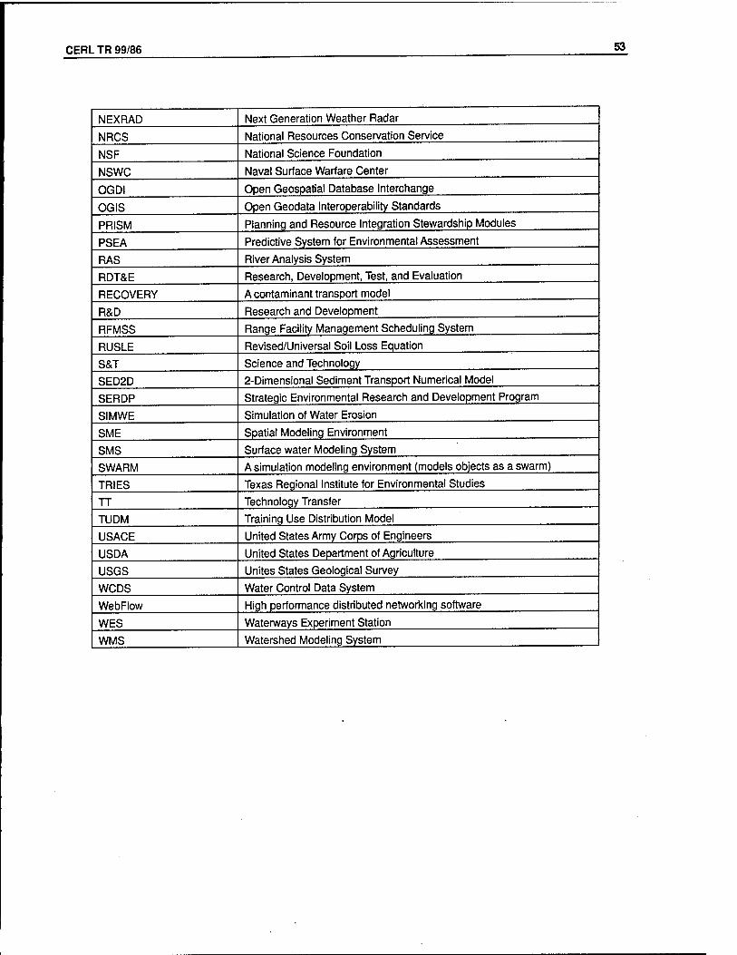
CERL TR 99/86 53
NEXRAD Next Generation Weather Radar
NRCS National Resources Conservation Service
NSF National Science Foundation
NSWC Naval Surface Warfare Center
OGDI Open Geospatial Database Interchange
OGIS Open Geodata Interoperability Standards
PRISM Planning and Resource Integration Stewardship Modules
PSEA Predictive System for Environmental Assessment
RAS River Analysis System
RDT&E Research, Development, Test, and Evaluation
RECOVERY A contaminant transport model
R&D Research and Development
RFMSS Range Facility Management Scheduling System
RUSLE Revised/Universal Soil Loss Equation
S&T Science and Technology
SED2D 2-Dimensional Sediment Transport Numerical Model
SERDP Strategic Environmental Research and Development Program
SIMWE Simulation of Water Erosion
SME Spatial Modeling Environment
SMS Surface water Modeling System
SWARM A simulation modeling environment (models objects as a swarm)
TRIES Texas Regional Institute for Environmental Studies
TT Technology Transfer
TUDM Training Use Distribution Model
USACE United States Army Corps of Engineers
USDA United States Department of Agriculture
USGS Unites States Geological Survey
WCDS Water Control Data System
WebFlow High performance distributed networking software
WES Waterways Experiment Station
WMS Watershed Modeling System
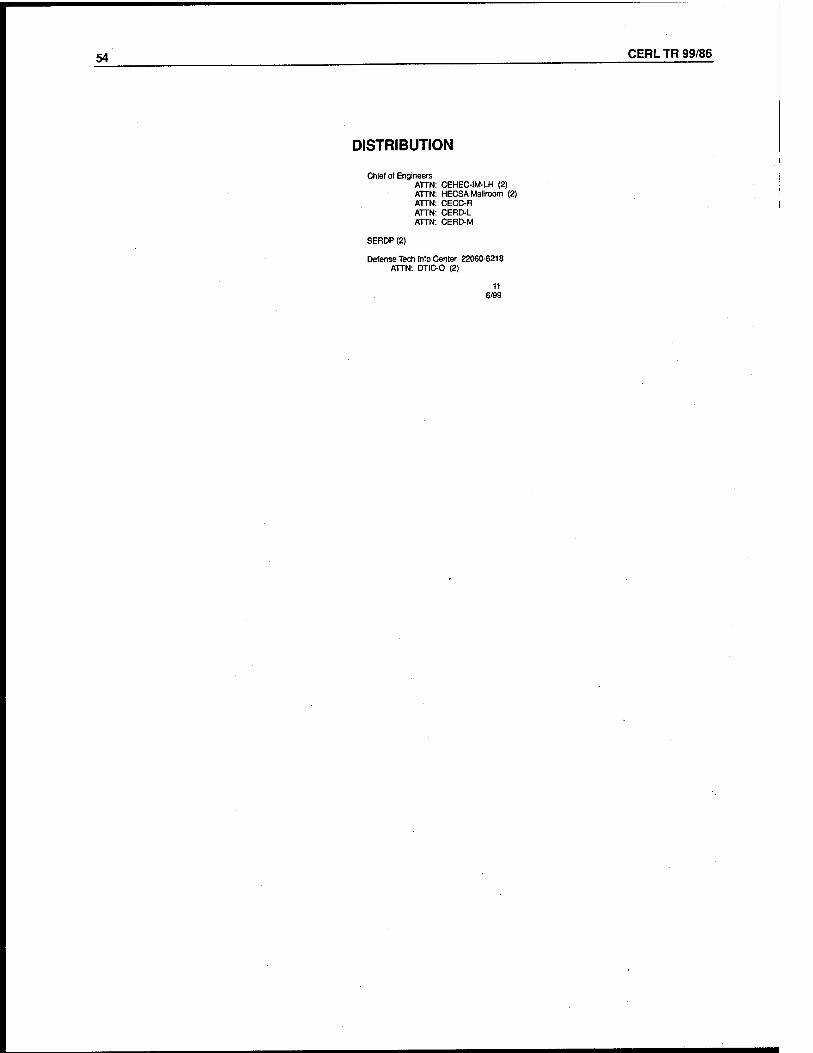
54 CERL TR 99/86
DISTRIBUTION
Chief of Engineers ATTN: CEHEC-IM-LH (2) ATTN: HECSAMailroom (2) ATTN: CECC-R ATTN: CERD-L ATTN: CERD-M
SERDP (2)
Defense Tech Info Center 22060-6218 ATTN: DTIC-0 (2)
11 6/99

REPORT DOCUMENTATION PAGE Form Approved OMB No. 0704-0188
Public reporting burden for this collection of information is estimated to average 1 hour per response, including the time for reviewing instructions, searching existing data sources, gathering and maintaining the data needed, and completing and reviewing the collection of information. Send comments regarding this burden estimate or any other aspect of this collection of Information, including suggestions for reducing this burden, to Washington Headquarters Services, Directorate for information Operations and Reports, 1215 Jefferson Davis Highway, Suite 1204, Arlington, VA 22202-4302, and to the Office of Management and Budget, Paperwork Reduction Project (0704-0188), Washington, DC 20503.
1. AGENCY USE ONLY (Leave Blank) 2. REPORT DATE
September 1999 3. REPORT TYPE AND DATES COVERED
Final
4. TITLE AND SUBTITLE
Development of an Integrated Land System in Support of Department of Defense Land Management
6. AUTHOR(S) Jeffery P. Holland and William D. Goran
7. PERFORMING ORGANIZATION NAME(S) AND ADDRESS(ES) U.S. Army Construction Engineering Research Laboratory (CERL) P.O. Box 9005 Champaign, IL 61826-9005
9. SPONSORING / MONITORING AGENCY NAME(S) AND ADDRESS(ES)
Strategic Environmental Research and Development Program ATTN: Program Manager 901 N. Stuart St., Suite 303 Arlington, VA 22203-1853
5. FUNDING NUMBERS
CS-1088
8. PEFORMING ORGANIZATION REPORT NUMBER
TR 99/86
10. SPONSORING / MONITORING AGENCY REPORT NUMBER
9. SUPPLEMENTARY NOTES
Copies are available from the National Technical Information Service, 5385 Port Royal Road, Springfield, VA 22161
12a. DISTRIBUTION / AVAILABILITY STATEMENT
Approved for public release; distribution is unlimited.
12b. DISTRIBUTION CODE
13. ABSTRACT (Maximum 200 words)
Managing land and water resources has become an increasingly difficult and challenging task for the Department of Defense (DoD). Although current and emerging technologies can help managers address the demands of environmental management, these technologies have limited linkage with modeling and decision support tools and they lack the full interoperability needed to support DoD land management decisionmakers.
This report describes a system that will provide a framework to bring together relevant science and technology, maximize synergism between technology initiatives, and improve the timeliness and effectiveness of technology delivery to managers. The system is the Land Management System (LMS).
LMS is an initiative of the U.S. Army Corps of Engineers and the Engineer Research and Development Center to design, develop, support, and apply an integrated capability for modeling and decision support technologies relevant to the management of DoD lands, seas, and airspace.
14. SUBJECT TERMS
Land Management System (LMS) ecosystem management
SERDP 15. NUMBER OF PAGES
56 16. PRICE CODE
17. SECURITY CLASSIFICATION OF REPORT
Unclassified
18. SECURITY CLASSIFICATION OF THIS PAGE
Unclassified
19. SECURITY CLASSIFICATION OF ASTRACT
Unclassified
20. LIMITATION OF ABSTRACT
SAR
NSN 7540-01-280-5500 Standard Form 298 (Rev. 2-89) Prescribed by ANSI SJd 239-18 298-102